Property of NMEA. Do not redistribute without permission from NMEA.
Page 1
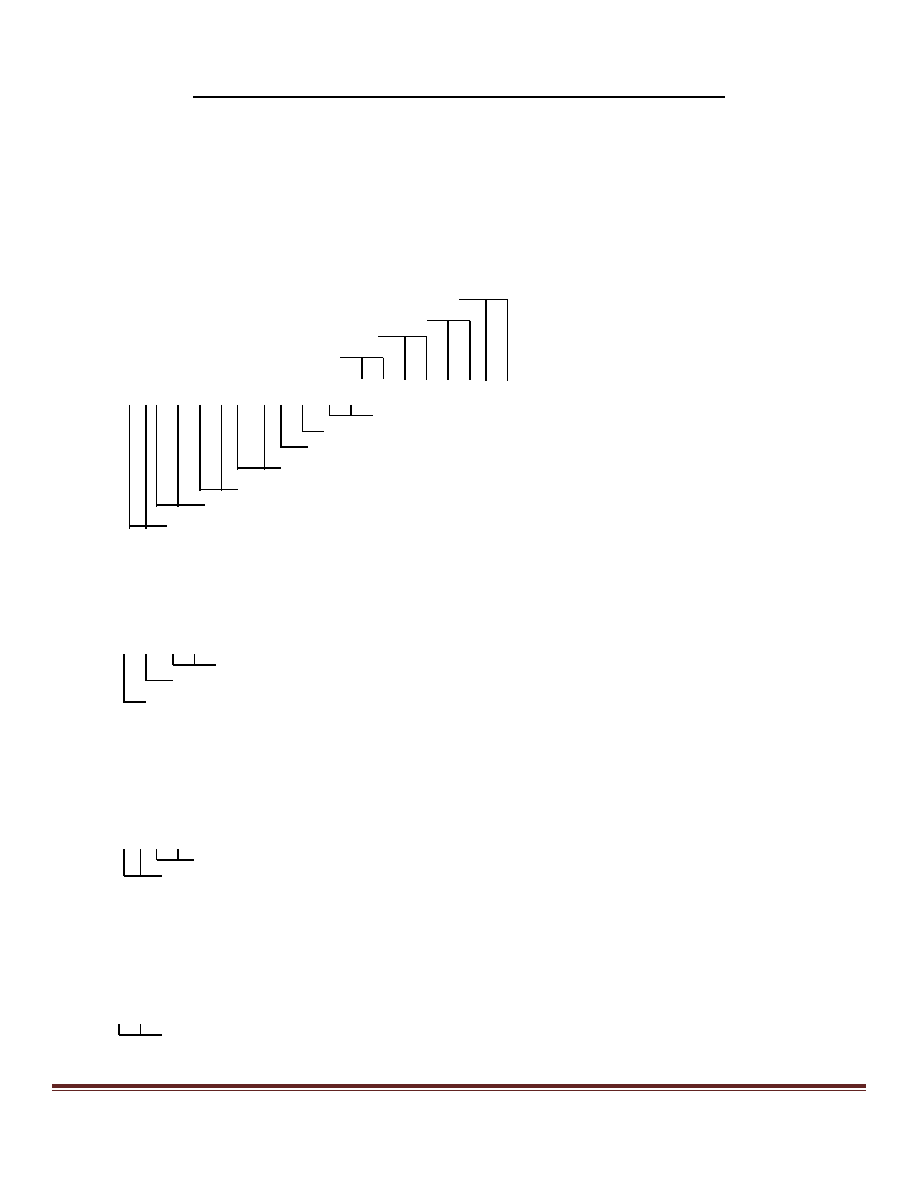
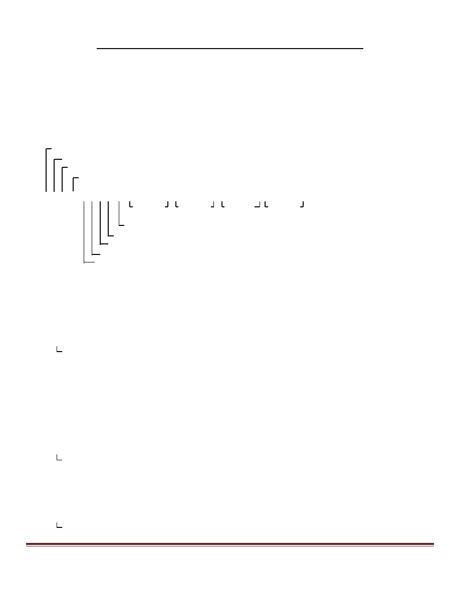
APA - Autopilot Sentence "A"
NMEA 0183 Sentences Not Recommended for New Designs
Approved by the NMEA 0183 Standard Committee
as of
October 1, 2008
Commonly used by autopilots this sentence contains navigation receiver warning flag status, cross-track-error, waypoint
arrival status and initial bearing from origin waypoint to the destination waypoint for the active navigation leg of the
journey.
Use of $--APB with additional data fields of heading-to-steer and bearing from present position to destination is
recommended.
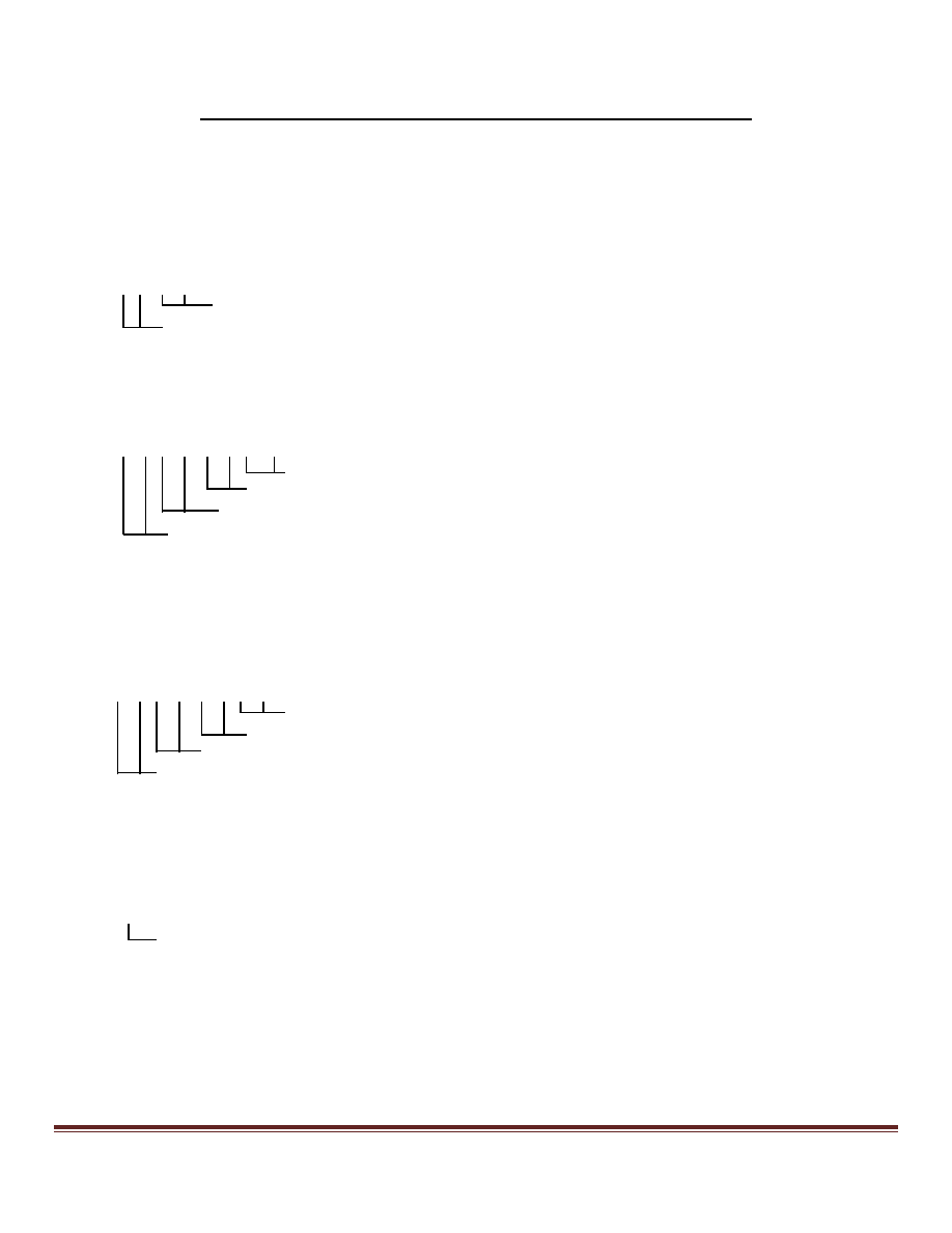
$--APA,A,A,x.x,a,N,A,A,x.x,M,c--c*hh<CR><LF>
Destination waypoint ID
Bearing origin to destination, Mag.
Status: perpendicular passed at waypoint
Status: arrival circle entered
XTE units, nautical miles
Direction to steer, L/R
Magnitude of XTE (cross-track-error)
Data status: Loran-C Cycle Lock warning flag
Data Status: "OR" of Loran-C Blink and SNR warning flags
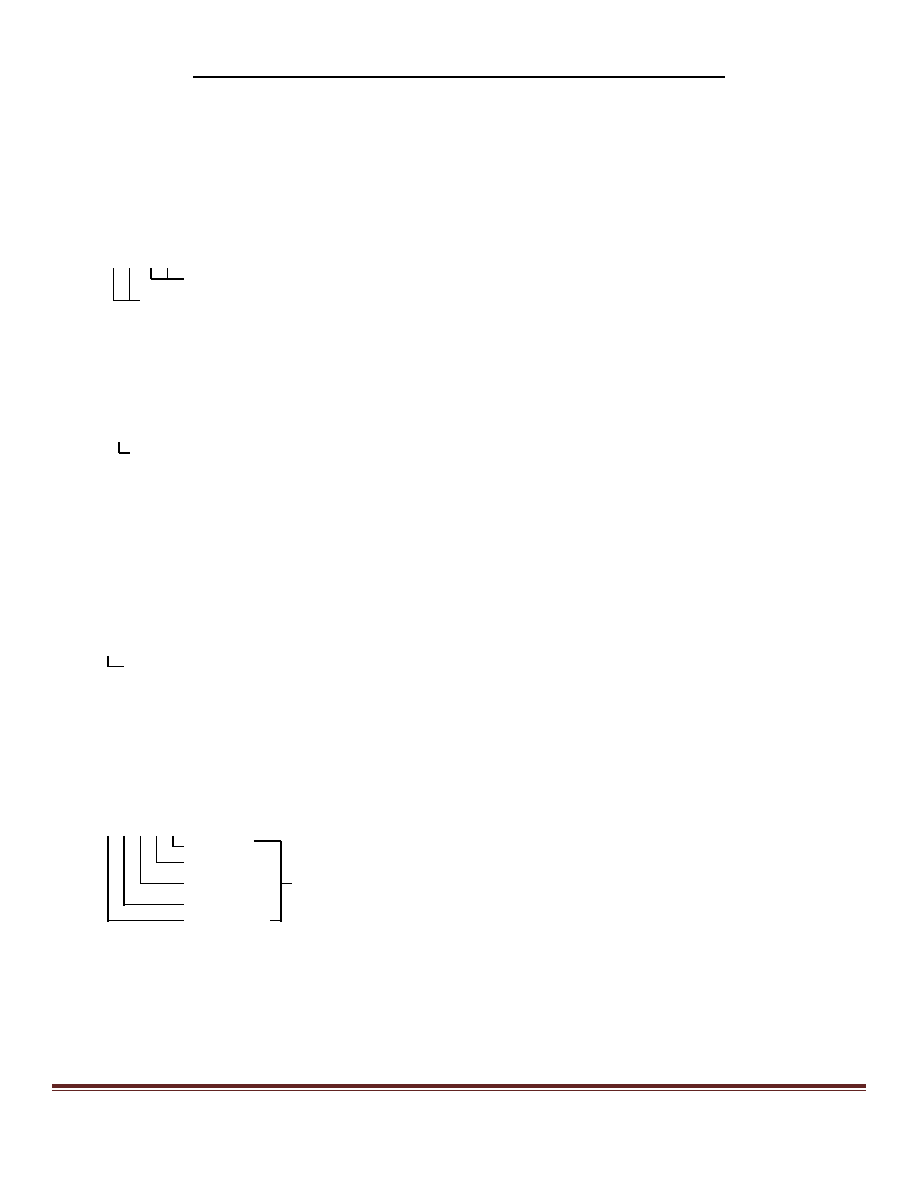
BER - Bearing & Distance to Waypoint, Dead Reckoning, Rhumb Line
BPI - Bearing & Distance to Point of Interest
Time (UTC) and distance & bearing to, and location of, a specified waypoint from present position:
BER: Calculated along the rhumb line from a dead reckoned present position. The use of
$--BEC using great circle calculations is recommended.
BPI: Calculated along a great circle path from a measured present position. Redundant with
BWC, the use of $--BWC is recommended.
Waypoint ID
Distance, nautical miles
Bearing, degrees Magnetic
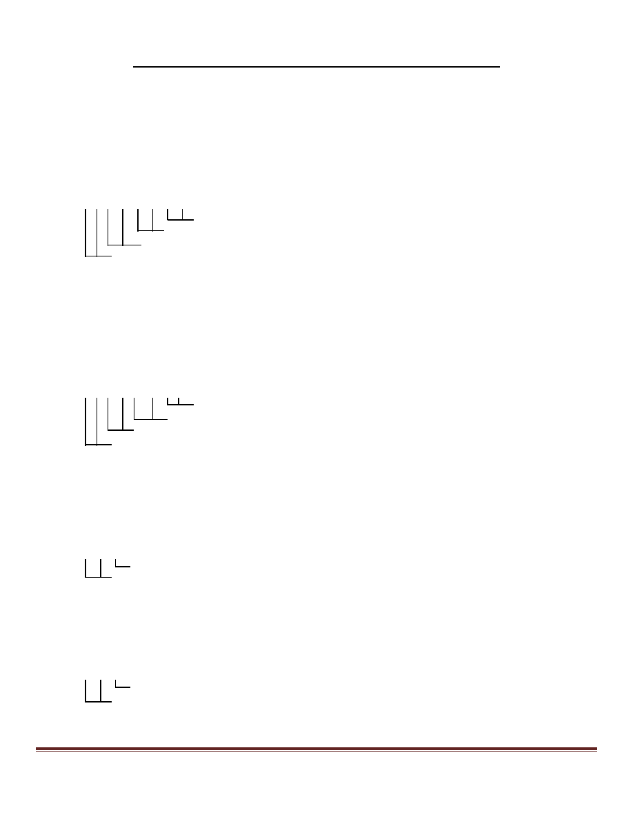
$--BER,hhmmss.ss,llll.ll,a,yyyyy.yy,a,x.x,T,x.x,M,x.x,N,c--c<CR><LF>
$--BPI,hhmmss.ss,llll.ll,a,yyyyy.yy,a,x.x,T,x.x,M,x.x,N,c--c<CR><LF>
Bearing, degrees T
Waypoint longitude, E/W
Waypoint latitude, N/S
UTC of observation
Property of NMEA. Do not redistribute without permission from NMEA.
Page 2
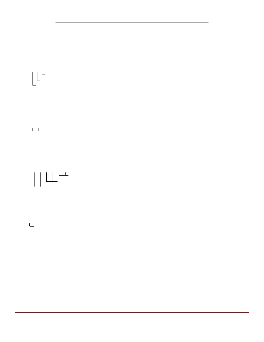
DBK - Depth Below Keel
NMEA 0183 Sentences Not Recommended for New Designs
Approved by the NMEA 0183 Standard Committee
as of
October 1, 2008
DBS - Depth Below Surface
Water depth referenced to the vessel's keel (DBK) or to the water surface (DBS).
The use of $--DPT is recommended in place of either of these.
$--DBK,x.x,f,x.x,M,x.x,F*hh<CR><LF>
$--DBS,x.x,f,x.x,M,x.x,F*hh<CR><LF>
Water depth, Fathoms
Water depth, Meters
Water depth, feet
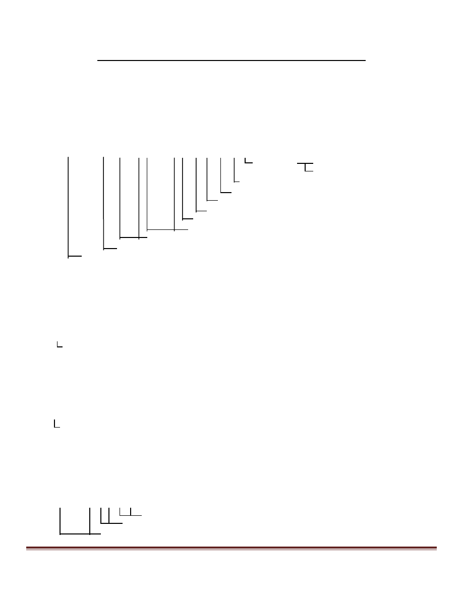
DCN – DECCA position
Status and lines-of-position for a specified DECCA chain.
$ -- DCN,xx,cc,x.x,A,cc,x.x,A,cc,x.x,A,A,A,A,x.x,N,x*hh<CR><LF>
Fix data basis
1
Position uncertainty, n. miles
Purple-line navigation use
A = Valid V = Data not valid
Green-line navigation use
A = Valid V = Data not valid
Red-line navigation use
A = Valid V = Data not valid
Purple
Green
Status: Red-master line, A = Valid V = Data not valid
Red line of position (LOP)
Red zone identifier, number-letter
DECCA chain identifier
Notes Fix data basis:
1 = Normal pattern
2 = Lane identification pattern
3 = Lane identification transmissions

Property of NMEA. Do not redistribute without permission from NMEA.
Page 3
DRU - Dual Doppler Auxiliary Data
NMEA 0183 Sentences Not Recommended for New Designs
Approved by the NMEA 0183 Standard Committee
as of
October 1, 2008
Depth, turn rate and % RPM in support of Doppler velocity systems.
The use of $--DPT is recommended for depth data, $--RPM for shaft rotation and $--ROT for rate of turn.
$--DRU,x.x,A,x.x,A,x.x*hh<CR><LF>
Propeller shaft rotation, % of maximum, "-" = astern
Status: Rate of turn
Rate of turn, degrees per minute, "-" = port
Status: Depth
Depth, meters
GDa - Dead Reckoning Positions
GLa - Loran-C Positions
GOa - OMEGA Positions

Property of NMEA. Do not redistribute without permission from NMEA.
Page 4
GXa - TRANSIT Positions
NMEA 0183 Sentences Not Recommended for New Designs
Approved by the NMEA 0183 Standard Committee
as of
October 1, 2008
Location and time at waypoint "c--c":
$--aF: predicted or estimated time
$--aaP: present position and time
$--aaA: past position and time
The use of waypoint location $--WPL (for past positions) or $--GLL (for present position) followed by time tag $--ZDA
is recommended for reporting past or present waypoint times; $--WPL followed by $--ZTG is recommended for
estimated time.
Dead reckoned positions:
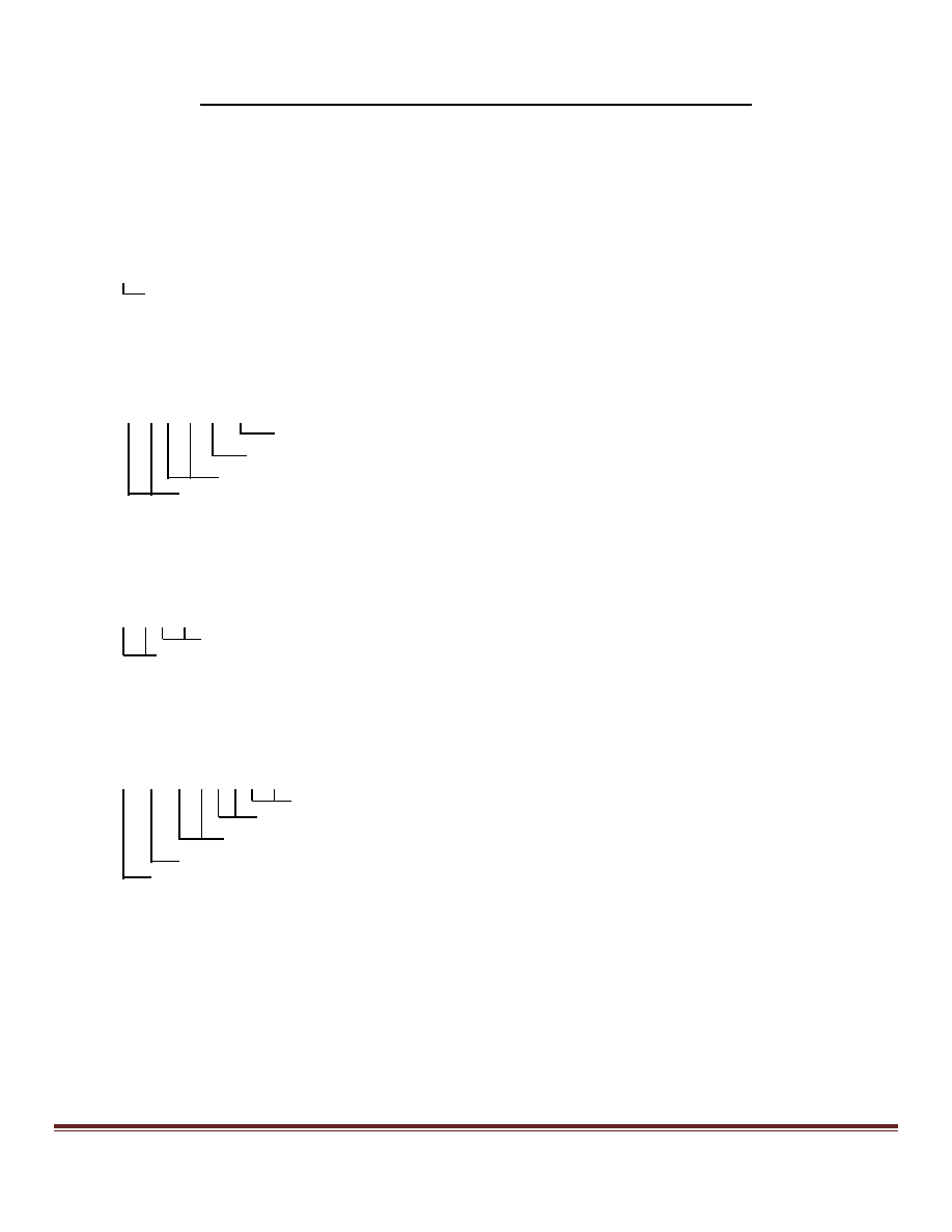
$--GDF,hhmmss.ss,llll.ll,a,yyyyy.yy,a,c--c*hh<CR><LF>
$--GDP,hhmmss.ss,llll.ll,a,yyyyy.yy,a,c--c*hh<CR><LF>
$--GDA,hhmmss.ss,llll.ll,a,yyyyy.yy,a,c--c*hh<CR><LF>
Loran-C determined positions:
$--GLF,hhmmss.ss,llll.ll,a,yyyyy.yy,a,c--c*hh<CR><LF>
$--GLP,hhmmss.ss,llll.ll,a,yyyyy.yy,a,c--c*hh<CR><LF>
$--GLA,hhmmss.ss,llll.ll,a,yyyyy.yy,a,c--c*hh<CR><LF>
Omega determined positions:
$--GOF,hhmmss.ss,llll.ll,a,yyyyy.yy,a,c--c*hh<CR><LF>
$--GOP,hhmmss.ss,llll.ll,a,yyyyy.yy,a,c--c*hh<CR><LF>
$--GOA,hhmmss.ss,llll.ll,a,yyyyy.yy,a,c--c*hh<CR><LF>
Waypoint ID
Longitude - E/W
Latitude - N/S
UTC of position fix
TRANSIT determined positions:
$--GXF,hhmmss.ss,llll.ll,a,yyyyy.yy,a,c--c,x*hh<CR><LF>
$--GXP,hhmmss.ss,llll.ll,a,yyyyy.yy,a,c--c,x*hh<CR><LF>
Satellite number
Waypoint ID
Longitude - E/W
Latitude - N/S
UTC of position fix
Property of NMEA. Do not redistribute without permission from NMEA.
Page 5
GTD - Geographical Position, Loran-C TDs
NMEA 0183 Sentences Not Recommended for New Designs
Approved by the NMEA 0183 Standard Committee
as of
October 1, 2008
Loran-C Time Difference (TD) lines of position for present vessel position.
The use of $--GLC is recommended.
$--GTD,x.x,x.x,x.x,x.x,x.x*hh<CR><LF>
TD 5, micro-seconds
TD 4, micro-seconds
TD 3, micro-seconds
TD 2, micro-seconds
TD 1, micro-seconds
GXA - TRANSIT Position
Location and time of TRANSIT fix at waypoint "c--c".
TRANSIT system is not operational, no recommended replacement.
$--GXA,hhmmss.ss,llll.ll,a,yyyyy.yy,a,c--c,x*hh<CR><LF>
Satellite number
Waypoint ID
Longitude - E/W
Latitude - N/S
UTC of position fix
HCC - Compass Heading
Vessel compass heading, which differs from magnetic heading by the amount of uncorrected magnetic deviation.
The use of $--HDG is recommended.
$--HCC,x.x*hh<CR><LF>
Compass heading, degrees
HCD - Heading and Deviation
Actual vessel magnetic heading, indicated compass heading and the difference (deviation) between them.
The use of $--HDG is recommended.
$--HCD,x.x,M,x.x,H,x.x,a*hh<CR><LF>
Magnetic deviation, degrees E/W
1
Compass heading, degrees
Magnetic heading, degrees
Notes:
1) Easterly deviation (E) subtracts from Compass Heading
Westerly deviation (W) adds to Compass Heading
Property of NMEA. Do not redistribute without permission from NMEA.
Page 6
HDM - Heading, Magnetic
NMEA 0183 Sentences Not Recommended for New Designs
Approved by the NMEA 0183 Standard Committee
as of
October 1, 2008
Actual vessel heading in degrees Magnetic.
The use of $--HDG is recommended.
$--HDM,x.x,M*hh<CR><LF>
Heading, degrees Magnetic
HTC
HDT - Heading, True
Actual vessel heading in degrees True produced by any device or system producing true heading.
$--HDT,x.x,T*hh<CR><LF>
Heading, degrees True
HVD - Magnetic Variation, Automatic
HVM - Magnetic Variation, Manually Set
Magnetic variation, automatically derived (calculated or from a data base) (HVD), or manually entered (HVM).
The use of $--HDG is recommended.
$--HVD,x.x,a*hh<CR><LF>
$--HVM,x.x,a*hh<CR><LF>
Magnetic variation, degrees E/W
1
Notes:
1) Easterly variation (E) subtracts from True Heading
Westerly variation (W) adds to True Heading
IMA - Vessel Identification
Limited utility, no recommended replacement.
Speed, knots
Heading, degrees Magnetic
Heading, degrees True
$--IMA,aaaaaaaaaaaa,aaaxxxx,llll.ll,a,yyyyy.yy,a,x.x,T,x.x,M,x.x,N*hh<CR><LF>
Longitude, E/W
Latitude, N/S
Radio call sign
12 character vessel name
Property of NMEA. Do not redistribute without permission from NMEA.
Page 7
MDA - Meteorological Composite
NMEA 0183 Sentences Not Recommended for New Designs
Approved by the NMEA 0183 Standard Committee
as of
October 1, 2008
Barometric pressure, air and water temperature, humidity, dew point and wind speed and direction relative to the surface
of the earth.
The use of $--MTW, $--MWV and $--XDR is recommended.
Wind speed, meters/second
Wind speed, knots
Wind direction, degrees Magnetic
Wind direction, degrees True
$--MDA,x.x,I,x.x,B,x.x,C,x.x,C,x.x,x.x,x.x,C,x.x,T,x.x,M,x.x,N,x.x,M*hh<CR><LF>
Dew point, degrees C
Absolute humidity, percent
Relative humidity, percent
Water temperature, degrees C
Air temperature, degrees C
Barometric pressure, bars
Barometric pressure, inches of mercury
MHU - Humidity
The use of $--XDR is recommended.
$--MHU,x.x,x.x,x.x,C*hh<CR><LF>
Dew point, degrees C
Absolute humidity, percent
Relative humidity, percent
MMB - Barometer
The use of $--XDR is recommended.
$--MMB,x.x,I,x.x,B*hh<CR><LF>
Barometric pressure, bars
Barometric pressure, inches of mercury
MTA - Air Temperature
The use of $--XDR is recommended.
$--MTA,x.x,C*hh<CR><LF>
Temperature, degrees C
Property of NMEA. Do not redistribute without permission from NMEA.
Page 8
MWH - Wave Height
NMEA 0183 Sentences Not Recommended for New Designs
Approved by the NMEA 0183 Standard Committee
as of
October 1, 2008
Limited utility, no recommended replacement.
$--MWH,x.x,f,x.x,M*hh<CR><LF>
Wave height, meters
Wave height, feet
MWS - Wind & Sea State
Limited utility, no recommended replacement.
$--MWS,xx,xx*hh<CR><LF>
Beaufort Sea State Code
Beaufort Wind Force Code
OLN - Omega Lane Numbers
Omega Lines of Positions (LOPs).
OMEGA system is not operational, no recommended replacement.
$--OLN,aa,xxx,xxx,aa,xxx,xxx,aa,xxx,xxx*hh<CR><LF>
Centilane number
Lane number
Pair 3, AB-GH
Pair 2
Pair 1
OLW - Omega Lane Width
OMEGA system is not operational, no recommended replacement.
$--OLW,x.x,N,xxxx,M*hh<CR><LF>
Lane width, meters
Lane width, nautical miles
OMP - OMEGA
OMEGA system is not operational, no recommended replacement.
$--OMP,1,aa,2,aa,3,aa*hh<CR><LF>
Pair 3, AB-GH
Pair 2
Pair 1
Property of NMEA. Do not redistribute without permission from NMEA.
Page 9
ONZ - Omega Zone Number
NMEA 0183 Sentences Not Recommended for New Designs
Approved by the NMEA 0183 Standard Committee
as of
October 1, 2008
OMEGA system is not operational, no recommended replacement.
$--ONZ,a*hh<CR><LF>
Station identifier, A-H
Rnn - Routes
Waypoint identifiers, listed in order with starting waypoint first, for route number "nn".
The use of $--RTE is recommended.
$--Rnn,c--c,--------,c--c*hh<CR><LF>
14 field sequence of route waypoint IDs
nn = Route number
SBK - Loran-C Blink Status
SCY - Loran-C Cycle Lock Status
Loran-C warning flags for Blink (SBK) and Cycle Lock (SCY) indicating that one or more Loran-C stations being
Warning Flag
used to
produce Lat/Lon and other navigation data are unreliable.
The use of $--GLC is recommended.
$--SBK,A*hh<CR><LF>
$--SCY,A*hh<CR><LF>
SCD - Loran-C ECDs
The use of $--LCD is recommended.
$--SCD,0,xxx,1,xxx,2,xxx,3,xxx,4,xxx,5,XXX*hh<CR><LF>
1 2 3 4 Secondary 5 ECD
Master signal ECD
Property of NMEA. Do not redistribute without permission from NMEA.
Page 10
SDB - Loran-C Signal Strength
NMEA 0183 Sentences Not Recommended for New Designs
Approved by the NMEA 0183 Standard Committee
as of
October 1, 2008
Limited utility, no recommended replacement.
$--SDB,x.x*hh<CR><LF>
Signal strength, dB
SGD - Position Accuracy Estimate
Estimate of position accuracy based on geometric dilution of precision (GDOP) and system noise, in feet and nautical
miles.
Limited utility, no recommended replacement.
$--SGD,x.x,N,x.x,f*hh<CR><LF>
Accuracy, feet
Accuracy, nautical miles
SGR - Loran-C Chain Identifier
The unique Loran-C Chain identifier, representing Group Repetition Interval (GRI) in tens
GRI, tens of microseconds
of microseconds (Group
Repetition Interval = {Chain ID}*10, microseconds).
The use of $--GLC is recommended.
$--SGR,xxxx*hh<CR><LF>
SIU - Loran-C Stations in Use
The use of $--GLC is recommended.
$--SIU,1,2,3,4,5,6,7,8*hh<CR><LF>
Stations in use, null fields for stations not in use
Property of NMEA. Do not redistribute without permission from NMEA.
Page 11
SLC - Loran-C Status
NMEA 0183 Sentences Not Recommended for New Designs
Approved by the NMEA 0183 Standard Committee
as of
October 1, 2008
Blink, Cycle, and SNR warning status and SNR value for all stations. Stations used in lat/lon conversion are identified.
The use of $--GLC and/or $--LCD is recommended.
Status: Blink Warning Flag, Master
Status: Cycle Lock Warning Flag, Master
Status: SNR Warning Flag, Master
SNR value, 000 to 999, Master
SLC,A,A,A,xxx,A,A,A,A,xxx,A,A,A,A,xxx,A,A,A,A,xxx,A,A,A,A,xxx,A,A,A,A,xxx*hh<CR><LF>
Sec. #2 Sec. #3 Sec. #4 Sec. #5
SNR value, 000 to 999, Secondary #1
Status: SNR Warning Flag, Secondary #1
Status: Cycle Lock Warning Flag, Secondary #1
Status: Blink Warning Flag, Secondary #1
Status: Secondary #1 used in Lat/Lon calculation
SNC - Navigation Calculation Basis
Basis for navigation calculations, Great Circle or Rhumb Line.
Limited utility, no recommended replacement.
$--SNC,a*hh<CR><LF>
Great Circle or Rhumb Line, G/R
SNU - Loran-C SNR Status
Loran-C warning flag for Signal-To-Noise-Ratio indicating that one or more Loran-C stations being used to produce
Lat/Lon and other navigation data are unreliable.
The use of $--GLC is recommended.
$--SNU,A*hh<CR><LF>
Warning Flag
SPS - Loran-C Predicted Signal Strength
Limited utility, no recommended replacement.
$--SPS,xx*hh<CR><LF>
Signal strength, dB
Property of NMEA. Do not redistribute without permission from NMEA.
Page 12
SSF - Position Correction Offset
NMEA 0183 Sentences Not Recommended for New Designs
Approved by the NMEA 0183 Standard Committee
as of
October 1, 2008
Amount of offset, and direction of offset, applied to measured position Lat/Lon to produce a displayed position Lat/Lon.
Limited utility, no recommended replacement.
$--SSF,x.x,a,x.x,a*hh<CR><LF>
Longitude offset, minutes E/W
Latitude offset, minutes N/S
STC - Time Constant
Time constant specified manually for use in navigation calculations.
Limited utility, no recommended replacement.
$--STC,xxx*hh<CR><LF>
Time constant, 000 to 999 seconds
STR - Tracking Reference
Transmitted prior to a sentence containing velocity-based data to indicate when velocity is measured over-the-ground or
relative to the water.
The use of appropriate ground or water-referenced approved sentences such as $--VBW, $--VHW or $--VTG is
recommended.
$--STR,a*hh<CR><LF>
A = Ground reference, V = Water reference
SYS - Hybrid System Configuration
Limited utility, no recommended replacement.
$--SYS,L,O,T,G,D*hh<CR><LF>
DECCA
GPS Null fields for
TRANSIT systems not
OMEGA in use
LORAN-C
Property of NMEA. Do not redistribute without permission from NMEA.
Page 13
TEC - TRANSIT Satellite Error Code & Doppler Count
NMEA 0183 Sentences Not Recommended for New Designs
Approved by the NMEA 0183 Standard Committee
as of
October 1, 2008
TRANSIT system is not operational, no recommended replacement.
$--TEC,A,A,A*hh<CR><LF>
Status: Iteration number
Status: Doppler count
Status: Maximum angle
TEP - TRANSIT Satellite Predicted Elevation
TRANSIT system is not operational, no recommended replacement.
$--TEP,x.x,D*hh<CR><LF>
Elevation, degrees
TGA - TRANSIT Satellite Antenna & Geoidal Heights -
TRANSIT system is not operational, no recommended replacement.
$--TGA,x.x,M,x.x,M,x.x,M*hh<CR><LF>
Antenna geoidal height, meters
Geoidal height, meters
Antenna height, meters
TIF - TRANSIT Satellite Initial Flag
TRANSIT system is not operational, no recommended replacement.
$--TIF,a*hh<CR><LF>
Normal operation = A
Set initialization data = V
Initialization data complete = J
Property of NMEA. Do not redistribute without permission from NMEA.
Page 14
TRF - TRANSIT Fix Data
NMEA 0183 Sentences Not Recommended for New Designs
Approved by the NMEA 0183 Standard Committee
as of
October 1, 2008
Time, date, position and information related to a TRANSIT fix.
TRANSIT system is not operational, no recommended replacement.
$--TRF,hhmmss.ss,xxxxxx,llll.ll,a,yyyyy.yy,a,x.x,x.x,x.x,x.x,xxx,A*hh<CR><LF>
Data status A = Data valid
V = Data invalid
Satellite ID
Update distance, nautical miles
Number of Doppler intervals
Number of iterations
Elevation angle
Longitude, E/W
Latitude, N/S
Date: ddmmyy
UTC of position fix
TRP - TRANSIT Satellite Predicted Direction of Rise
TRANSIT system is not operational, no recommended replacement.
$--TRP,aa*hh<CR><LF>
Southeasterly = SE, southwesterly = SW
TRS - TRANSIT Satellite Operating Status
TRANSIT system is not operational, no recommended replacement.
$--TRS,a*hh<CR><LF>
Acquiring = A Calculating = c Error = e
Message = m Test = T Dead reckoning = U
VCD - Current at Selected Depth
Limited utility, no recommended replacement.
$--VCD,x.x,f,x.x,M,x.x,N,x.x,M*hh<CR><LF>
Current, meters/second
Current, knots
Depth, feet and meters
Property of NMEA. Do not redistribute without permission from NMEA.
Page 15
VPE - Speed, Dead Reckoned Parallel to True Wind
NMEA 0183 Sentences Not Recommended for New Designs
Approved by the NMEA 0183 Standard Committee
as of
October 1, 2008
Limited utility, no recommended replacement.
$--VPE,x.x,N,x.x,M*hh<CR><LF>
Speed, meters/second, "-" = downwind
Speed, knots, "-" = downwind
VTA - Actual Track
Limited utility, possible use of $--VTG for a portion of the data.
$--VTA,x.x,T,x.x,M,x.x,N,x.x,N*hh<CR><LF>
Distance made good, naut. miles
Speed made good, knots
Track made good, degrees Magnetic
Track made good, degrees True
VTI - Intended Track
Limited utility, no recommended replacement.
$--VTI,x.x,T,x.x,M,x.x,N,x.x,N*hh<CR><LF>
Distance made good, naut. miles
Speed made good, knots
Intended track, degrees Magnetic
Intended track, degrees True
VWE - Wind Track Efficiency
Limited utility, no recommended replacement.
$--VWE,x.x*hh<CR><LF>
Efficiency, percent
Property of NMEA. Do not redistribute without permission from NMEA.
Page 16
VWR - Relative (Apparent) Wind Speed and Angle
NMEA 0183 Sentences Not Recommended for New Designs
Approved by the NMEA 0183 Standard Committee
as of
October 1, 2008
Wind angle in relation to the vessel's heading and wind speed measured relative to the moving vessel.
The use of $--MWV is recommended.
$--VWR,x.x,a,x.x,N,x.x,M,x.x,K*hh<CR><LF>
Wind speed, Km/Hr
Wind speed, meters/second
Measured wind Speed, knots
Measured wind angle relative to the vessel, 0 to 180
o
, left/right L/R of vessel heading
VWT - True Wind Speed and Angle
True wind angle in relation to the vessel's heading and true wind speed referenced to the water. True wind is the vector
sum of the Relative (Apparent) wind vector and the vessel's velocity vector relative to the water along the heading line of
the vessel. It represents the wind at the vessel if it were stationary relative to the water and heading in the same direction.
The use of $--MWV is recommended.
$--VWT,x.x,a,x.x,N,x.x,M,x.x,K*hh<CR><LF>
Wind speed, Km/Hr
Wind speed, meters/second
Calculated wind Speed, knots
Calculated wind angle relative to the vessel, 0 to 180
o
, left/right L/R of vessel heading
WDC - Distance to Waypoint
Distance from present position to the specified waypoint.
The use of $--BWC is recommended.
$--WDC,x.x,N,c--c*hh<CR><LF>
Waypoint identifier
Distance, nautical miles
WDR - Waypoint Distance, Rhumb Line
The use of $--WDC using great circle calculations is recommended.
$--WDR,x.x,N,c--c*hh<CR><LF>
Waypoint ID
Distance, nautical miles
Property of NMEA. Do not redistribute without permission from NMEA.
Page 17
WFM - Route Following Mode
NMEA 0183 Sentences Not Recommended for New Designs
Approved by the NMEA 0183 Standard Committee
as of
October 1, 2008
Limited utility, no recommended replacement.
$--WFM,a*hh<CR><LF>
Mode: "A" = automatic, "V" = manual
WNR - Waypoint-to-Waypoint Distance, Rhumb Line
The use of $--WNC using great circle calculations is recommended.
$--WNR,x.x,N,x.x,K,c--c,c--c*hh<CR><LF>
FROM waypoint ID
TO waypoint ID
Distance, kilometers
Distance, nautical miles
YWP - Water Propagation Speed
Limited utility, no recommended replacement.
$--YWP,x.x,f,x.x,M*hh<CR><LF>
Speed, meters/second
Speed, feet/second
YWS - Water Profile
Limited utility, no recommended replacement.
$--YWS,x.x,x.x,x.x,C,x.x,f,x.x,M*hh<CR><LF>
Depth, meters
Depth, feet
Temperature at depth, degrees C
Chlorinity, parts/thousand
Salinity, parts/thousand
Property of NMEA. Do not redistribute without permission from NMEA.
Page 18
ZAA - Time, Elapsed/Estimated
NMEA 0183 Sentences Not Recommended for New Designs
Approved by the NMEA 0183 Standard Committee
as of
October 1, 2008
Elapsed time from point-of-interest.
The use of $--ZFO is recommended.
$--ZFI,hhmmss.ss,hhmmss.ss,c--c*hh<CR><LF>
Waypoint ID
Elapsed time from waypoint
UTC
Arrival time at point-of-interest.
The use of $--ZTG is recommended.
$--ZPI,hhmmss.ss,hhmmss.ss,c--c*hh<CR><LF>
Waypoint ID
Arrival time at waypoint
UTC
Estimated time of arrival at waypoint.
The use of $--ZTG is recommended.
$--ZTA,hhmmss.ss,hhmmss.ss,c--c*hh<CR><LF>
Waypoint ID
Estimated arrival time at waypoint
UTC
Estimated time to event/point-of-interest.
The use of $--ZTG is recommended.
$--ZTE,hhmmss.ss,hhmmss.ss,c--c*hh<CR><LF>
$--ZTI,hhmmss.ss,hhmmss.ss,c--c*hh<CR><LF>
Waypoint ID
Estimated time-to-go to waypoint
UTC
Arrival time at waypoint.
The use of $--ZTG is recommended.
$--ZWP,hhmmss.ss,hhmmss.ss,c--c*hh<CR><LF>
Waypoint ID
Arrival time at waypoint
UTC

Property of NMEA. Do not redistribute without permission from NMEA.
Page 19
ZCD - Timer
NMEA 0183 Sentences Not Recommended for New Designs
Approved by the NMEA 0183 Standard Committee
as of
October 1, 2008
Limited utility, no recommended replacement.
$--ZCD,xxxxxx,a*hh<CR><LF>
Control: "+" = count up
"-" = count down
"V" = stop count
Timer initial value, seconds
ZEV - Event Timer
Limited utility, no recommended replacement.
$--ZEV,hhmmss.ss,hhmmss.ss,a,c--c*hh<CR><LF>
Waypoint ID
Control: "+" = count up
"-" = count down
"V" = stop count
Timer initial value
UTC
ZLZ - Time of Day
Time of day in hours-minutes-seconds, both with respect to (UTC) and the local time zone.
The use of $--ZDA is recommended.
$--ZLZ,hhmmss.ss,hhmmss.ss,xx*hh<CR><LF>
Local zone description
1
, 00 to12
Local time
UTC
Notes:
1) Zone description is the number of whole hours added to local time
ZZU - Time, UTC
to obtain GMT, Zone
description is negative for East longitudes.
The use of $--ZDA is recommended.
$--ZZU,hhmmss.ss*hh<CR><LF>
UTC
Document Outline
- APA - Autopilot Sentence "A"
- BER - Bearing & Distance to Waypoint, Dead Reckoning, Rhumb Line
- BPI - Bearing & Distance to Point of Interest
- DBK - Depth Below Keel
- DBS - Depth Below Surface
- DCN – DECCA position
- DRU - Dual Doppler Auxiliary Data
- GDa - Dead Reckoning Positions
- GLa - Loran-C Positions
- GOa - OMEGA Positions
- GXa - TRANSIT Positions
- GTD - Geographical Position, Loran-C TDs
- GXA - TRANSIT Position
- HCC - Compass Heading
- HCD - Heading and Deviation
- HDM - Heading, Magnetic
- HVD - Magnetic Variation, Automatic
- HVM - Magnetic Variation, Manually Set
- IMA - Vessel Identification
- MDA - Meteorological Composite
- MHU - Humidity
- MMB - Barometer
- MTA - Air Temperature
- MWH - Wave Height
- MWS - Wind & Sea State
- OLN - Omega Lane Numbers
- OLW - Omega Lane Width
- OMP - OMEGA
- ONZ - Omega Zone Number
- Rnn - Routes
- SBK - Loran-C Blink Status
- SCY - Loran-C Cycle Lock Status
- SCD - Loran-C ECDs
- SDB - Loran-C Signal Strength
- SGD - Position Accuracy Estimate
- SGR - Loran-C Chain Identifier
- SIU - Loran-C Stations in Use
- SLC - Loran-C Status
- SNC - Navigation Calculation Basis
- SNU - Loran-C SNR Status
- SPS - Loran-C Predicted Signal Strength
- SSF - Position Correction Offset
- STC - Time Constant
- STR - Tracking Reference
- SYS - Hybrid System Configuration
- TEC - TRANSIT Satellite Error Code & Doppler Count
- TEP - TRANSIT Satellite Predicted Elevation
- TGA - TRANSIT Satellite Antenna & Geoidal Heights -
- TIF - TRANSIT Satellite Initial Flag
- TRF - TRANSIT Fix Data
- TRP - TRANSIT Satellite Predicted Direction of Rise
- TRS - TRANSIT Satellite Operating Status
- VCD - Current at Selected Depth
- VPE - Speed, Dead Reckoned Parallel to True Wind
- VTA - Actual Track
- VTI - Intended Track
- VWE - Wind Track Efficiency
- VWR - Relative (Apparent) Wind Speed and Angle
- VWT - True Wind Speed and Angle
- WDC - Distance to Waypoint
- WDR - Waypoint Distance, Rhumb Line
- WFM - Route Following Mode
- WNR - Waypoint-to-Waypoint Distance, Rhumb Line
- YWP - Water Propagation Speed
- YWS - Water Profile
- ZAA - Time, Elapsed/Estimated
- ZCD - Timer
- ZEV - Event Timer
- ZLZ - Time of Day
- ZZU - Time, UTC
Wyszukiwarka
Podobne podstrony:
Recommendations for the Design of Bridges [Benson]
Why telly is not good for you
M000549 B Eng Oil recommendation for SP14 35
42 577 595 Optimized Heat Treatment and Nitriding Parametres for a New Hot Work Steel
Writing Its Not Jst For Fun Anymore!
ATELIER KEMPE THILL Specific neutrality A manifesto for new collective housing
plany, We have done comprehensive research to gauge whether there is demand for a new football stadi
Complex sentences analitycal gammar for advanced ESL stude
PBO PD03 F03 Crew not fit for further work on board
McGraw Hill Briefcase Books Skills for New Managers
Abstract Synergistic Antifungal Effect of Lactoferrin with Azole Antifungals against Candida albican
Not Just For Christmas Annabelle Jacobs
Bradley M Kuhn Picking Up Perl A Tutorial Book for New Perl Programmers
Spencer, Wen Rituals for a New God
HS SPME a tool for new insights into the long term thermo
więcej podobnych podstron