
The International Journal of Nautical Archaeology (2004) 33.1: 2–13
doi: 10.1111/j.1095-9270.2004.002.x
© 2004 The Nautical Archaeology Society.
Published by Blackwell Publishing Ltd. 9600 Garsington Road, Oxford OX4 2DQ, UK and 350 Main Street, Malden, MA 02148, USA.
Blackwell Publishing Ltd
C. Ward & R. D. Ballard: Deep-water archaeological survey in the Black Sea
Deep-water Archaeological Survey in the Black Sea:
2000 Season
Cheryl Ward
Department of Anthropology, Florida State University, Tallahassee, FL 32306-7772 USA
Robert D. Ballard
Institute for Archaeological Oceanography, Graduate School of Oceanography, University of Rhode Island,
Narragansett, RI 02882-1197 USA
Recent archaeological survey by sidescan sonar and remotely operated vehicles (ROVs) resulted in the discovery of one of the
best-preserved seagoing ships from antiquity in the anoxic waters of the Black Sea. Three shipwrecks from the 4th to 6th
centuries AD, with cargoes of shipping jars from Sinop, Turkey, were found at depths of about 100 m; the fourth sits upright
on the sea-bed, buried to deck level in sediment. A description of each site and identification of visible site components is
followed by a discussion of directions and possible implications of future research.
© 2004 The Nautical Archaeology Society
Key words: maritime archaeology, shipwrecks, Black Sea, ROV, Sinop, ship construction.
R
ecent survey work in the Black Sea as
part of a long term project developed
by the Institute for Exploration (IFE)
resulted in the discovery of one of the best-
preserved seagoing ships from antiquity (Ballard
et al., 2001). This ship, found at a depth of 320 m,
and three others located between 85 and 101 m
date to the 4th to 6th centuries AD, and may
provide information about both technological
change and trade in the Black Sea during a period
of political, social, and economic transition
through the study of ship construction techniques.
Historical and archaeological studies indicate
that the area of Sinop had developed long-
distance exchange as early as 4,500 BC, and that
seaborne traffic in the region was most intense
during the period of late antiquity, between the
2nd and 7th centuries AD (Hiebert et al., 1997;
Hiebert, 2001). Remote examination of four ship-
wrecks from the latter period has provided the
direct evidence for Black Sea maritime trade so well
attested by the distribution of ceramics on land.
The application of both traditional and
innovative remote sensing methods to deep-water
archaeological survey supports standard archae-
ological approaches to site survey and allows the
non-destructive evaluation of sites in a marine
environment more hostile than most. The anoxic
environment of the Black Sea, hostile to many
biological organisms that destroy wood in
oxygenated waters, provides an excellent testing
site for deepwater archaeological survey. This
report describes the methodology used to locate
four ships in 2000, presents preliminary conclu-
sions about those vessels, and discusses directions
and possible implications of future research.
Background
In 1976 Willard Bascom suggested that the deep,
anoxic waters of the Black Sea (Fig. 1) might
preserve a treasure trove of ships from antiquity
because typical wood-devouring organisms could
not survive there (1976: 38). At depths greater
than 150 m the Black Sea contains insufficient
oxygen to support most familiar biological life
forms; a suboxic zone in the next 20 to 50 m has
both low oxygen and low sulphides, and in the
anoxic layer below 200 m water chemistry studies
consistently document relatively high concentrations
of sulphides and low oxygen (Murray et al., 1989;
Codispoti et al., 1991).
C. WARD & R. D. BALLARD: DEEP-WATER ARCHAEOLOGICAL SURVEY IN THE BLACK SEA
© 2004 The Nautical Archaeology Society
3
Originally a land-locked fresh water lake, the
Black Sea was inundated with salt water from
the Mediterranean Sea during the Holocene.
The influx of salt water essentially smothered the
fresh water below it because a lack of internal
motion and mixing meant that no fresh oxygen
reached the deep waters (Oguz et al., 1993). The
influx probably took place about 7000 years ago.
Its speed and intensity are debated (Ryan et al.,
1997; Uchupi and Ross, 2000; Görür et al., 2001;
Aksu et al., 2002), but the extinction of fresh
water molluscs and replacement by saline species
seems to have occurred between 7460 and 6820
BP (uncorrected radiocarbon years) according to
radiocarbon dates from mollusc shells near Sinop
collected on a 1999 Black Sea expedition (Ballard
et al., 2000).
The collaborative efforts of the Institute for
Exploration, the University of Pennsylvania,
University of Rhode Island Graduate School
of Oceanography, the Massachusetts Institute
of Technology, and the Institute of Nautical
Archaeology resulted in a programme of
terrestrial and marine survey focused on Sinop,
Turkey (Ballard et al., 2001). The potential for
wood preservation in the deep waters of the
Black Sea (up to 2210 m deep), and the long
occupation and central role Sinop played in
regional trade, including extensive exchange with
settlements on the Crimean peninsula made this
region attractive for testing several hypotheses.
The Black Sea Trade Project, a multi-year
terrestrial survey near Sinop, led by Fredrik
Hiebert, Owen Doonan and Alex Gantos,
identified small, relatively isolated, Neolithic
sites on elevated areas that often overlooked
watercourses, as well as a Bronze Age settlement
on one of Sinop’s high points and a number of
later sites (Hiebert et al., 1997). A rich record
of farming groups from the time of Greek
colonisation through the medieval period
(Kassab Tezgör and Tatlican, 1998) adds to
previous archaeological knowledge of the region,
and has suggested to Hiebert (2001) that the
Sinop sites exhibit specialised adaptation to the
coastal maritime environment.
Underwater surveys of Sinop’s anchorage,
portions of the submerged coastline, and ex-
ploration of deeper waters along possible trade
routes linking Sinop to the Crimean peninsula
and towards Byzantium to the west took place
each year from 1998 to 2000 with a fourth season
in 2003. A side-scan sonar survey of waters less
than 60 m deep near Sinop harbour in 1998
produced several dozen anomalies examined
through images provided by camera-carrying
ROVs in 1999 (Mindell et al., 1998; Ward, 2000).
Most of these low-relief anomalies proved to be
colonies of large-shelled molluscs, but a late 18th-
century AD iron anchor, a large jar, and the
remains of a 19th-century steamship were also
identified (Fig. 2). Work north-east of Sinop
focused on a search for the ancient coastline of
the Black Sea, and included sampling by
dredging (Ballard et al., 2000).
2000 survey season
In 2000, the archaeological survey conducted
under water focused on exploration of the
sea-bed about 15–30 km west of Sinop, with
additional deep-water survey east and north of
the promontory. The project had several goals.
We sought to discover whether human habitation
sites could be identified on the ancient submerged
landscape, to examine the sea-bed for shipwrecks,
to test the hypothesis that the anoxic waters
below 200 m would protect shipwrecks from
the expected biological attacks on organic
components, and to seek data about an ancient
trade route between Sinop and the Crimea
indicated by terrestrial archaeological remains.
Side-scan survey in search of features such as
relic stream beds in the submerged landscape
and shipwrecks, followed by target evaluation
through examining images obtained by cameras
on an ROV, were the season’s primary activities
(Coleman et al., 2000). A DSL-120 phased-array,
120 kHz side-scan sonar developed by the Woods
Hole Oceanographic Institution was towed at
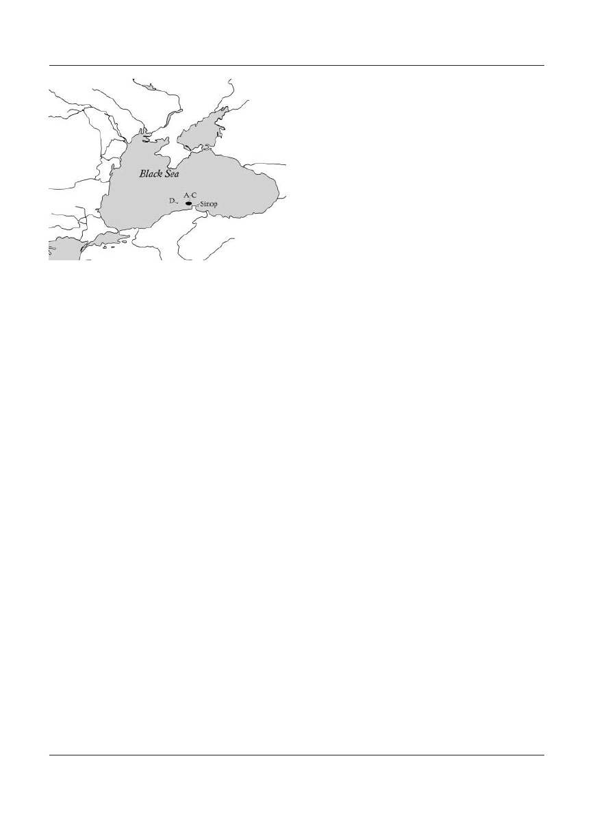
Figure 1. The Black Sea, with approximate locations of ship
finds and Sinop.
NAUTICAL ARCHAEOLOGY, 33.1
4
© 2004 The Nautical Archaeology Society
about 40–50 m above the sea-bed, and provided
returns over 600
m, which enabled relatively
small acoustic anomalies (shipwreck-sized) to be
identified.
After anomalies were evaluated, we selected
targets for visual inspection and photography
using a combination of two vehicles: the optical
tow sled Argus and the remotely-operated vehi-
cle Little Hercules, both developed by IFE
(Coleman, 2002) and operated from Northern
Horizon, a research vessel with direct positioning
capability. Argus acts as a platform for lights and
cameras, including a 3-chip video camera, an
electronic still camera, and a 35-mm colour still
camera. Shipboard operators control its cameras
and thrusters, which provide it with independent
movement. Argus easily located acoustic targets
originally identified by the DSL-120 with a 675
kHz fan-beam scanning sonar mounted directly
on the tow sled.
Little Hercules is tethered directly to Argus,
reducing the effects of ship motion and cable
drag on the ROV. Little Hercules carries cameras
capable of providing extremely high quality
images; it also has a variety of sensors for
pressure, depth, and compass heading, and
thrusters for movement both laterally and
vertically. It carries the same obstacle-avoidance
sonar, which functioned effectively in quickly
locating desired acoustic targets. Both vehicles
worked well, and provided outstanding visual
images (Fig. 3). Precise measurement of ar-
chaeological materials was not a goal during the
2000 season, so all measurements provided here
were estimated through use of depth sensors or
comparison to objects of known size.
Shipwrecks A, B, C
More than 200 acoustic targets were identified by
the DSL-120, and 52 were subsequently inspected
by Little Hercules and Argus. Three shipwrecks
(A-C) discovered west of Sinop during the 2000
season date to the Late Roman or early Byzantine
period, probably between the 4th and late 6th
centuries AD. Although Sinop served as a
primary trade node in the Black Sea, the wrecks
we located are west of the trade route predicted
by the preponderance of Sinopian ceramics on
the Crimean peninsula (Ballard et al., 2001: 608).
On wrecks A-C, ovoid mounds of distinctive
carrot-shaped shipping jars of a style associated
with Sinop retain much of their original stacking
pattern. The jars may have carried a variety of
well-attested Black Sea products such as olive oil,
honey, wine, or fish sauce, but the contents are
presently unknown as no artefacts were recovered
from any of these wreck sites in 2000.
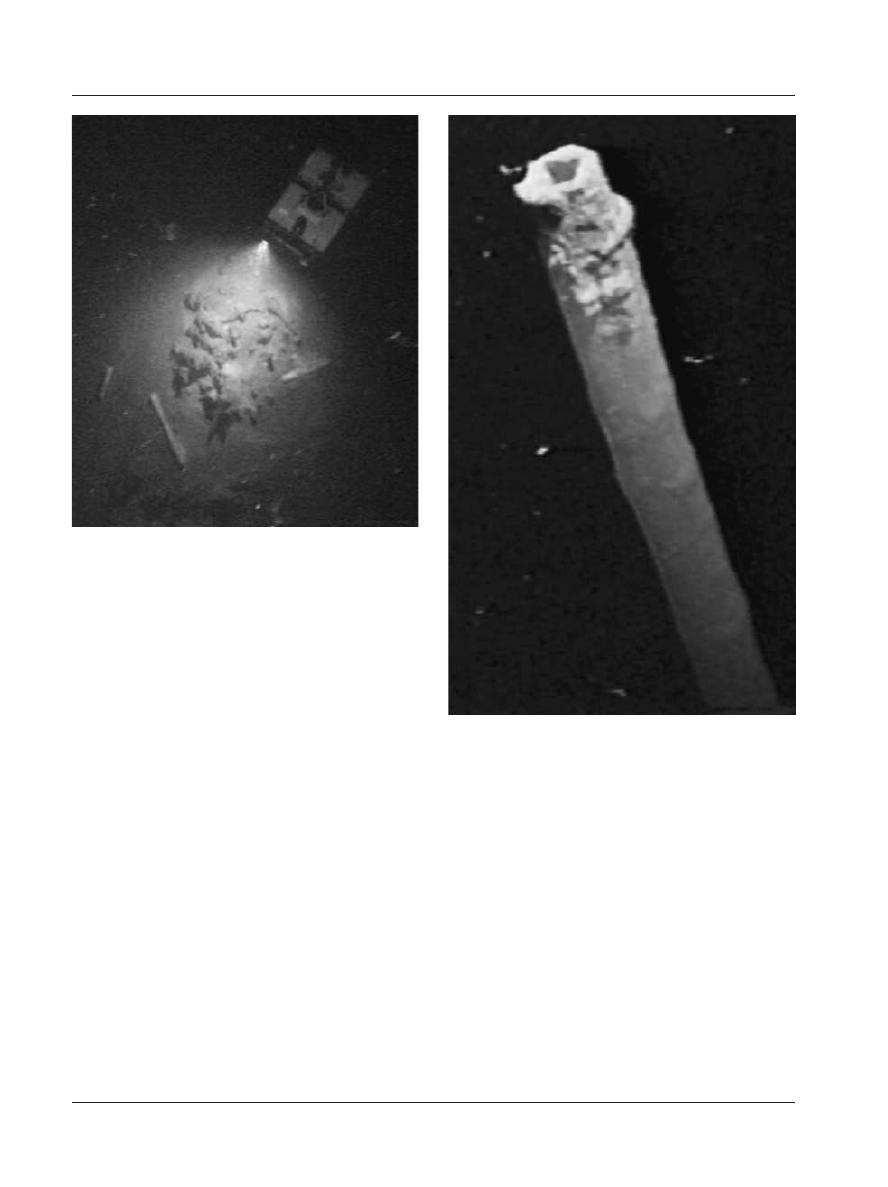
Shipwreck A appeared in the video images
from Argus as Little Hercules’ lights illuminated
a wall of shipping jars standing about 2 m above
the sea-bed (Fig. 4). It is an isolated hump on the
sea-bed at a depth of 101 m. The mound appears
to be about 20 m long and 10 m wide. Shipping
jars on this site most closely correspond to 4th to
5th century AD examples from an amphora kiln
near Sinop (Kassab Tezgör and Tatlican, 1998).
Because the amphoras highest on the mound
have fallen over without displacing those still
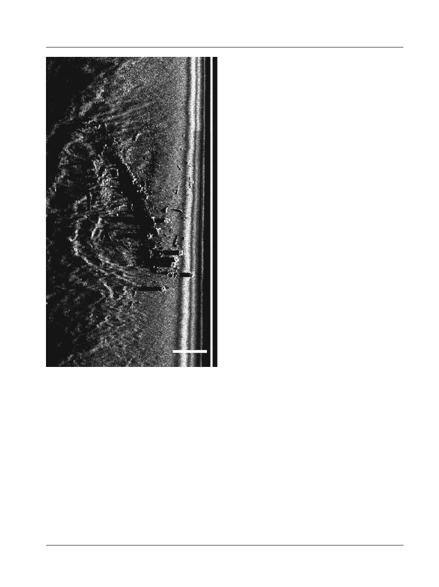
Figure 2. Acoustic image of the wreck of a 19th-century
steamship east of Sinop harbour (Courtesy D. Mindell;
copyright Marine Sonic Technologies).
C. WARD & R. D. BALLARD: DEEP-WATER ARCHAEOLOGICAL SURVEY IN THE BLACK SEA
© 2004 The Nautical Archaeology Society
5
standing in rows beneath them, it is likely that the
ship settled upright on the sea-bed, gradually
being both buried in and filled with sediment as
exposed wood was devoured by the larva of
Teredo navalis, the shipworm.
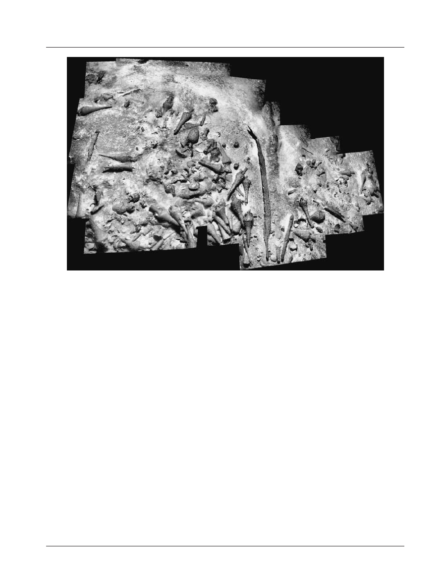
Shipwreck B, covering an area approximately
24 m long and 12 m wide at 85 m depth, also
consisted of a large pile of shipping jars, but
several types are visible, as are multiple timbers
protruding from within the mound and on it
(Fig. 5). In addition to the Sinop-style jars,
several LR1 (hour-glass shaped) amphoras
similar to examples excavated on the Yassiada
Byzantine shipwreck and dating from the 5th to
late 6th century AD are present (van Doorninck,
2002). The presence of exposed timbers, some of
which are partially buried in the mound, is
intriguing, but at this time it is unclear whether
any of them belong to the original ship. No
fastenings or other features are apparent.
Two discrete and mostly buried piles of carrot-
shaped shipping jars at a depth of 85 m comprise
shipwreck C (Fig. 6). The visit to this site was
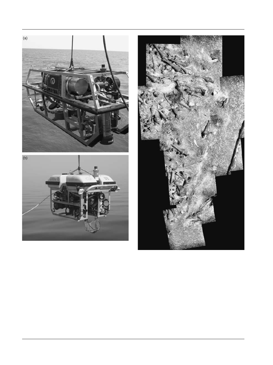
Figure 3. a) Optical tow sled Argus; b) imaging ROV Little
Hercules (Photo courtesy Institute for Exploration/Institute
for Archaeological Oceanography-URI/GSO).
Figure 4. Partial photomosaic of Shipwreck A from elec-
tronic still camera images. (Courtesy Institute for Explora-
tion/Institute for Archaeological Oceanography-URI/
GSO).
NAUTICAL ARCHAEOLOGY, 33.1
6
© 2004 The Nautical Archaeology Society
quite brief, and intended primarily to test survey
methodology for deep-water procedures.
The shipwrecks serve as excellent traps for
objects that fall from the surface or move with
currents along the sea-bed, as there is modern
rubbish—plastic bags and bottles—as well as
sticks and brush, on each site’s surface. Other
acoustic targets (for example boulders or tree
trunks) showed the same pattern of accumulation
of debris. Because radiocarbon-dated wood samples
from other surface deposits in the area include
relatively recent wood, it is difficult directly to
associate any of the timbers with the ancient
ships from their position on the ancient materials.
Reviewing the images provided no indisputable
evidence of ancient woodworking techniques, but
additional documentation is required. Full
mapping of the sites is scheduled for 2003.
Shipwreck D
Unlike the other wreck sites, shipwreck D pro-
vides us with unprecedented opportunities to
document hull construction during a time of
transition already documented elsewhere in the
ancient world. The fourth ship, Shipwreck D, was
identified as a target on the ocean bottom at a
depth of 320 m about 25 km north of Sinop. Its
sonar signature, a long, slender upright feature
on the sea-bed, transformed itself into a wooden
mast, standing about 11 m above the sea-bed
under the lights of the ROVs (Fig. 7). At deck level
the mast disappears into thick, dark sediment
topped with a soft, whitish organic substance
biologists call ‘marine snow’, the remains of tiny
organisms which live in the water column.
Elements rarely present on shallower shipwreck
sites are beautifully preserved here. A 5th-century
vessel at Anse des Laurons near Marseille had
portions of a hatch and deck preserved (Gassend
et al., 1984), and recent excavations at Olbia
include a mast (Riccardi, 2002), but discovery of
a mast in place with associated spars and deck
structures from the 5th century AD is unique. A
radiocarbon date of 1610 ± 40 (Beta-147532)
calibrated to 410–520 AD was obtained on a
sample of wood from the robust timber
designated as a rudder support in the stern and
identified as fir (Abies sp.). A second wood
fragment was identified as oak (Quercus sp.,
white oak group), but its original location on the
ship is not known.
Figure 5. Photomosaic of part of Shipwreck B from electronic still camera images (Courtesy Institute for Exploration/
Institute for Archaeological Oceanography-URI/GSO).
C. WARD & R. D. BALLARD: DEEP-WATER ARCHAEOLOGICAL SURVEY IN THE BLACK SEA
© 2004 The Nautical Archaeology Society
7
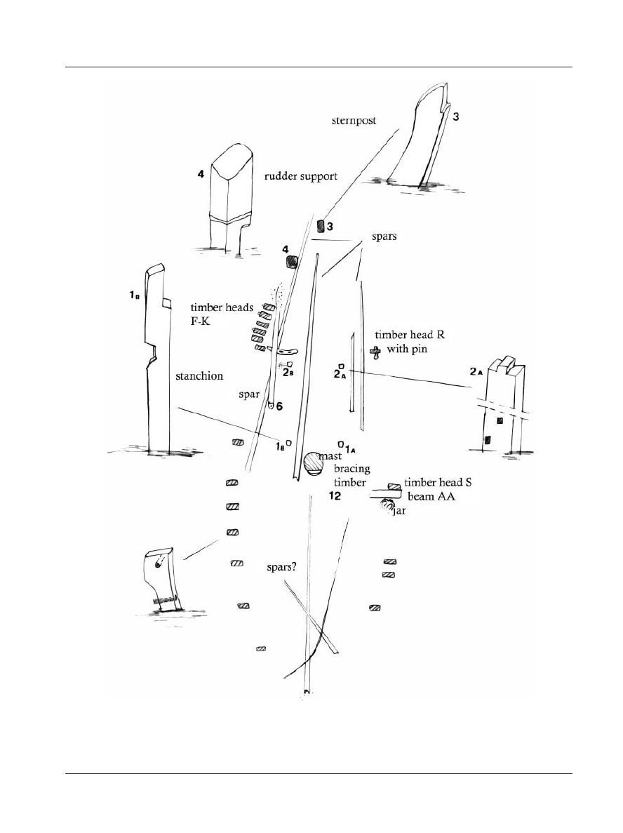
A number of long ridges, possibly spars
partially covered with drifted sediment, lie along
the deck, some between two pairs of uprights aft
of the mast. The direction of the mast’s cant
permitted the determination of the bow and stern.
Timbers protrude above the sediment, and
allow a rough tracing of the ship’s shape and
dimensions (Figs 8 and 9). Identifiable timbers
include an endpost, a starboard rudder support,
18 timber heads, one pin, at least five spars, a
beam, the mast and its bracing timber, two pairs
of stanchions, and a handful of treenails. The
area of the deck outlined by these timbers is
between 12 and 14 m long and about 4 m wide.
All measurements are approximate and subject to
confirmation by further investigation.
The curved timber aligned with the mast and
about 6 m aft of it on the central axis of the ship
is designated as the sternpost. Protruding at least
0.5 m above the sediment, the timber curves
upwards and inwards, and incorporates one half
of a scarf on its outer face. The scarf implies
another timber once extended the sternpost, but
no timbers visible in the area correspond to its
dimensions. Moving from the endpost to the
starboard sheerline, we next encounter a
substantial upright timber with a notch on its
after face. Tentatively designated as a rudder
support, this timber is firmly fixed to the hull. Its
position and relative bulk are reminiscent of a
similarly upright timber visible on depictions of
Roman ships in the Ostia mosaics, the Torlonia
relief, and on Trajan’s column (Fig. 10).
Timbers that rise above the sediment surface
and are rectangular in section, with the narrow
dimension oriented towards the vessel’s centreline,
are designated as top timbers. These uppermost
components of frames have a gentle inward curve
on their inner face, and a slightly shaped or eroded
area near the sediment level on the outer face. A
hole approximately 25 mm in diameter passes
through forward and aft faces of the timber heads;
the holes are aligned with those in adjacent top
Figure 6. Shipwreck C from video camera image (Courtesy
Institute for Exploration/Institute for Archaeological
Oceanography-URI/GSO).
Figure 7. Acoustic image of Shipwreck D, top of mast with
cordage (Courtesy Institute for Exploration / Institute for
Archaeological Oceanography-URI/GSO).
NAUTICAL ARCHAEOLOGY, 33.1
8
© 2004 The Nautical Archaeology Society
Figure 8. Plan of Shipwreck D with labelled elements, including details (C. Ward).
C. WARD & R. D. BALLARD: DEEP-WATER ARCHAEOLOGICAL SURVEY IN THE BLACK SEA
© 2004 The Nautical Archaeology Society
9
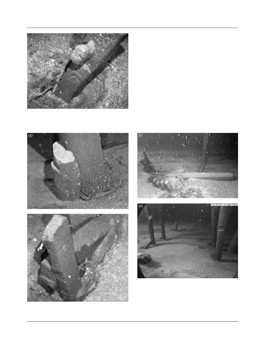
timbers. At least one of these holes was filled
with a wooden pin (Fig. 11), probably for securing
rigging lines. Lost pins, or perhaps cordage
strung between frame heads to enclose the deck,
may once have filled the other holes.
A group of six close-set top timbers includes
one that seems to be out of alignment (F-K on
Fig. 9), perhaps because the heavy spar just
inboard of it may have fallen on it and broken it.
There are 12, possibly 13, timber heads on the
starboard side. Only five timber heads are visible
on the port side, but two of these have unique
features. Top timber R incorporates a c.20 cm
pin, and S has a notch cut into its outer face.
In the region of midships, a tantalising glimpse
of a single transverse beam connected to top
timber S hints at the nature of the vessel’s
interior. Beams at deck level function in several
ways. In addition to providing transverse support
to the ship, beams may serve for the attachment
of deck planking. Because the sole deck beam
visible in the 2000 expedition photographs is
directly forward of the mast, it is also possible
Figure 9. Sheer view of Shipwreck D with labelled elements (C. Ward).
Figure 10. Ship with rudder support and stanchions from
Trajan’s column, 113 AD (Photo courtesy Romisch-
Germanischen Zentralmuseums, Mainz).
NAUTICAL ARCHAEOLOGY, 33.1
10
© 2004 The Nautical Archaeology Society
that this beam functioned as a mast partner.
Both the beam end and the top timber beside it
have a notch cut into the surface originally
adjacent to the inner planking surface (Fig. 12a).
At this stage in the investigations, existence of a
planked deck is uncertain. This is a small ship —
only 12 to 14 m long—and it is possible that, as
on many other ancient ships, decking was present
only at the bow and stern, leaving the interior
open for easy access to the hold.
The mast is completely preserved, without a
trace of erosion or damage. A small cavity at its
tip suggests a masthead was once attached there,
probably to facilitate attaching the yard. The
mast cants or perhaps has slipped towards one
end of the vessel (Fig. 12a), here provisionally
designated as the forward end. The mast appears
Figure 12. Shipwreck D hull components. a) Detail of bracing timber at mast; b) Beam and top timber; c) Tenon on the
forward end of spar 6 (right) with timber heads F-K (left); d) Stanchions aft of the mast (Courtesy Institute for Exploration/
Institute for Archaeological Oceanography-URI/GSO).
Figure 11. Pin in top timber, Shipwreck D (Courtesy
Institute for Exploration/Institute for Archaeological
Oceanography-URI/GSO).
C. WARD & R. D. BALLARD: DEEP-WATER ARCHAEOLOGICAL SURVEY IN THE BLACK SEA
© 2004 The Nautical Archaeology Society
11
to be fitted tightly to a short, upright timber,
possibly a brace fixed in the bottom of the hull.
Two large treenail heads are visible on the sides
of the bracing timber, suggesting that they were
driven through the timber perpendicular to the
mast. The bracing timber has a stepped cut,
probably to facilitate lashing the mast to it.
On the starboard side of the mast is a spar
running two-thirds of the length of the ship. A bit
further aft is the butt end of another spar, about
twice the diameter of the first, with a semi-
circular tenon that has a 20 cm hole drilled
through it (Fig. 12c). It is likely to be a yard.
Several other spars appear to lie aft of the mast,
between the stanchions, and run out on either
side of the sternpost.
Two pairs of stanchions stand aft of the mast,
about 1.2 m above the sediment level (Fig. 12d).
The stanchions probably were connected with
cross-pieces near deck level, one of which is
present at stanchion 2b. The aft pair is topped by
square tenons, presumably fashioned to fit into
mortises on a now-missing cross-piece. A notch
facing inboard on each of the forward pair may
have served to secure rigging lines; the upper
ends of these stanchions seem to be purposefully
rounded. There are a few illustrations of similar
structures on Roman ships, including a ship on
Trajan’s column (Fig. 10) and on 2nd- and
4th-century hulls in Tunisian mosaics (Fig. 13)
(Basch, 1987: figs. 1105, 1109, 1110). The arrange-
ment seems to have supported yards and spars
both while the sail was in use and when it was
lowered, and to provide a place for tying off
lines.
Disappointingly for ship scholars and his-
torians of technology, there are few indications of
how the planks of this ship were held together,
and not even a shadow of a stain of metal
corrosion products which might provide a clue to
how hull components were interlinked. There are
no mortise-and-tenon fastenings, no sewing, and
no metal nails visible in the images from the 2000
expedition. Treenails about 3 cm in diameter
protrude about 25 mm beyond the outboard face
of some frame ends, and suggest the presence of
a sheer strake about that thick. Treenails also are
visible on the starboard and port sides of the
bracing timber.
Examination of the site did not clarify a
number of unresolved issues: although there is no
visible wood erosion or damage from the teredo
mollusc, a number of hull components are
‘missing’. Particularly noticeable is the lack of a
top rail or sheer strake although 18 timber
heads stand proud of the sea-bed. Although the
ship seems to be sitting evenly beneath the
sediment, this is only about a third of the number
expected from the distribution pattern in Figs 8
and 9.
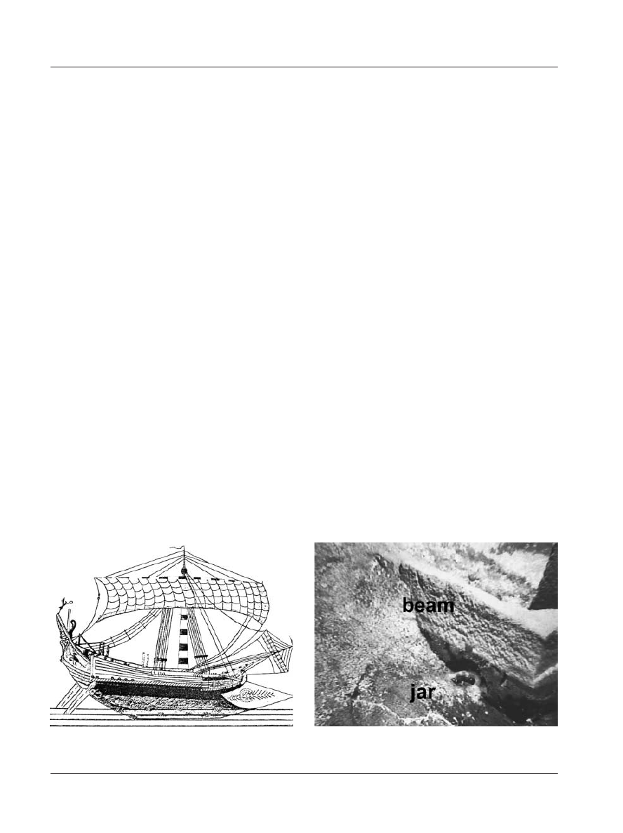
Other than the ship itself, the only artefacts we
recorded on Shipwreck D were a modern blue
plastic bottle and a small ancient jug, whose neck
and handles are visible below the outboard end
of the beam (Fig. 14). Sediment movement and
angle of approach limited our view of the jug,
and thus any interpretations of its significance,
but it is of primary interest as a potential
chronological and cultural marker for future
expeditions.
Figure 13. Mid-3rd-century AD ship with two pairs of stan-
chions in a mosaic from the Maison de la Procession at El
Djem, Tunisia (after Revue Archéologique 1974, 48: 23).
Figure 14. Two-handled ceramic jug beneath beam on Ship-
wreck D (Courtesy Institute for Exploration/Institute for
Archaeological Oceanography-URI/GSO).

NAUTICAL ARCHAEOLOGY, 33.1
12
© 2004 The Nautical Archaeology Society
Conclusions
Shipwreck D may be one of the earliest lateen-
rigged ships to be studied by archaeologists. The
angle of the mast and the lack of fittings on it
suggest that a lateen sail is the most likely
configuration for this small vessel. Lateen sails
spread into Egypt from the western Indian Ocean
during the first century, and reached the
Mediterranean and Aegean soon after. We know
little about sailing on the Black Sea before the
medieval period, although an early Byzantine
sarcophagus identified by the Black Sea Trade
Project land survey illustrates a much larger
square-sailed vessel typical of late Roman types.
A brief underwater survey in 1997 located a ship
loaded with 6th-century amphoras, but nothing
is known about its construction or rigging
(Kassab Tezgör et al., 1998). By the medieval
period, lateen sails were common.
Radiocarbon dates and the shape of shipping
jars suggest that all four of the shipwrecks date
to the end of the Roman period and the
beginning of the Byzantine period in the Black
Sea. In the Aegean and Mediterranean, people
built ships in the traditional plank-oriented
manner, although we see signs of change in the
4th century. For millennia, most shipwrights
created the planking shell first, then inserted
frames and fastened them to the sides (Steffy,
1994).
Beginning in the 4th century, fastenings
between plank edges became smaller and less
securely fitted, and some frames were set up
before the side planking in order to help control
hull shape (van Doorninck, 1976). Ship timbers
from Tantura Lagoon on Israel’s Mediterranean
coast show that by the 6th century some hulls
were built completely frame first (Kahanov, 2000)
although at least one other vessel at Tantura was
built with closely-set mortise-and-tenon fastenings
during the 7th century (Kahanov and Royal,
2001). Factors such as difficulty in obtaining the
skilled labour necessary for plank-oriented
construction and economic constraints that
favoured the construction of smaller hulls
probably influenced the change in construction
methods. Van Doorninck (1976: 130) points out
that timber is more efficiently used, and iron nails
and bolts only partially driven into the frames do
most of the work of fastening the late 4th-century
AD Yassiada hull.
Learning more about how the Black Sea wrecks
were built would help us compare regional economic
effects and technological change between the
Black Sea and the Aegean. It is possible that we
might learn there are as many differences here as
exist between the eastern and western Mediterranean
(where a strong tradition of sewn ships is dem-
onstrated by archaeological finds).
The Institute for Exploration Black Sea
expeditions relied on remote sensing with side-
scan sonar in shallow and deep water to identify
potential archaeological sites to be examined by
ROVs equipped with obstacle-avoidance sonar
and cameras for identification and analysis. High
quality images support archaeological evaluation
of sites and permit decision-making about future
investigations. The hypothesis that the anoxic
waters of the Black Sea would allow extra-
ordinary organic preservation is borne out by
the discovery of a shipwreck 1,500 years old with
excellent preservation of features above the
sediment layer. A planned expedition for 2003
will use a larger, tool-equipped ROV for subsurface
testing of Shipwreck D and other sites.
Acknowledgements
We wish to thank the Turkish Ministry of Culture and the Turkish General Directorate for Monuments and Museums for
permission to conduct this survey, and in particular, to express our gratitude to Dr. Alpay Paßinli and Dr. Harun Özdaß of
the Ministry of Culture, and Fuat Dereli and other researchers from the Sinop Museum. This expedition was envisioned and
organised by Chief Scientist Robert D. Ballard of the Institute for Exploration and Institute for Archaeological Oceanography,
and achieved through the generous support of the Office of Naval Research, the National Oceanic and Atmospheric
Administration, the National Geographic Society and their Expedition Council, the J. M. Kaplan Fund, and the Institute of
Nautical Archaeology.
The work of chief archaeologist Fredrik Hiebert and his team in the region since 1994 laid the groundwork for the success
of these explorations, and we are grateful for his participation in and dedication to the project. We also thank the research
and technical teams from the Institute for Exploration, Marine Sonic, and Woods Hole Oceanographic Institute, and in
particular, Dwight Coleman of the University of Rhode Island, David Mindell of the Massachusetts Institute of Technology,
chief of operations Catherine Offinger, and chief engineer James Newman. Erkut Arcak, Ayße Atauz, Brendan Foley,
Katherine Croff, Candace Major, Jennifer Smith, Kathryn Willis, and Francesco Torre also contributed to the success of the
1999 and 2000 seasons, and have our sincere appreciation. Cheryl Ward, who joined this project at the invitation of George
F. Bass of INA, thanks him for his continuing support.

C. WARD & R. D. BALLARD: DEEP-WATER ARCHAEOLOGICAL SURVEY IN THE BLACK SEA
© 2004 The Nautical Archaeology Society
13
References
Aksu, A. E., Hiscott, R. N., Mudie, P. J., Rochon, A., Kaminski, M. A., Abrajano, T., and Yaßar, D., 2002, Persistent
Holocene outflow from the Black Sea to the eastern Mediterranean contradicts Noah’s flood hypothesis, GSA Today 12.5:
4 –10.
Ballard, R. D., Coleman, D. F., and Rosenberg, G., 2000, Further evidence of abrupt Holocene drowning of the Black Sea
shelf, Marine Geology 170: 254 – 61.
Ballard, R. D., Hiebert, F. T., Coleman, D. F., Ward, C., Smith, J. S., Willis, K., Foley, B., Croff, K., Major, C., and Torres,
F., 2001, Deepwater archaeology of the Black Sea: The 2000 season at Sinop, Turkey, American Journal of Archaeology 105:
607–23.
Basch, L., 1987, Le musée imaginaire de la marine antique. Athens.
Bascom, W., 1976, Deep Water, Ancient Ships. Garden City and New York.
Codispoti, L. A., Friederich, G. E., Murray, J. W., and Sakamoto, C. E., 1991, Chemical variability in the Black Sea:
Implications of continuous vertical profiles that penetrated the oxic/anoxic interface, Deep Sea Research 38: S691–S710.
Coleman, D. F., 2002, Underwater archaeology in Thunder Bay National Marine Sanctuary, Lake Huron—Preliminary results
from a shipwreck mapping survey, Marine Technology Society Journal 36.3: 33 – 44.
Coleman, D. F., Newman, J. B., and Ballard, R. D., 2000, Design and implementation of advanced underwater imaging
systems for deep sea marine archaeological surveys, in IEEE Oceanic Engineering Society (ed.), Oceans 2000 MTS/IEEE
Conference and Exhibition, I, 661– 665. Piscataway.
Gassend, J. M., Liou, B., and Ximémès, S., 1984, L’épave 2 de l’Anse des Laurons (Martigues, Bouches-du-Rhône), Archae-
onautica 4: 75 –106.
Görür, N., Çagatay, N., Emre, Ö., Alpar, B., Sakınç, M., Islamoglu, Y., Algan, O., Erkal, T., Keçer, M., Akkök, R., and
Karlık, G., 2001, Is the abrupt drowning of the Black Sea Shelf at 7150 yr BP a myth?, Marine Geology 176: 65 –73.
Hiebert, F., 2001, Black Sea coastal cultures: trade and interaction, Expedition 43: 11–20.
Hiebert, F., Smart, D., Gantos, A., and Doonan, O., 1997, From mountaintop to ocean bottom: a comprehensive approach
to archaeological survey along the Turkish Black Sea coast, in J. Tanacredi and J. Loret (eds.), Ocean Pulse: A Critical
Diagnosis, 93 –108. New York.
Kassab Tezgör, D. and Tatlican, I., 1998, Fouilles des atelier d’amphores à Demirci près de Sinope en 1996 et 1997, Anatolia
Antiqua 6: 423 – 42.
Kassab Tezgör, D., Tatlican, I., and Özdaß, H., 1998, Prospection sous-marine près de la côte sinopéenne: transport
d’amphores depuis l’atelier et navigation en mer Noire, Anatolia Antiqua 6: 443 –9.
Kahanov, Y., 2000, The Tantura B shipwreck. Tantura Lagoon, Israel: Preliminary hull construction report, in J. Litwin (ed.),
Down the River to the Sea. Eighth International Symposium on Boat and Ship Archaeology, Gdansk, 1997, 151– 4. Gdansk.
Kahanov, Y. and Royal, J., 2001, Analysis of hull remains of the Dor D Vessel, Tantura Lagoon, Israel, IJNA 30: 257– 65.
Mindell, D., Foley, B., and Webster, S., 1998, Black Sea survey: Cruise report. Manuscript on file at the Massachusetts
Institute of Technology and the Institute for Exploration, Mystic, Conn.
Murray, J. W., Jannasch, H. W., Honjo, S., Anderson, R. F., Reeburgh, W. S., Top, Z., Friederich, G. E., Codispoti, L. A.,
and Izdar, E., 1989, Unexpected changes in the oxic/anoxic interface in the Black Sea, Nature 338: 411–13.
Oguz, T., Latun, V. S., Latif, M. A., Vladimirov, V. L., Sur, H. I., Markov, A. A., Ozsoy, E., Kotovshichkov, B. B., Eremeev,
V. N., and Unluata, U., 1993, Circulation in the surface and intermediate layers of the Black Sea, Deep Sea Research 1.40:
1597– 612.
Riccardi, E., 2002, A ship’s mast discovered during excavation of the Roman port at Olbia, Sardinia, IJNA, 31: 268 –9.
Ryan, W. B. F., Pitman, W. C. III, Major, C. O., Shimkus, K., Moskalenko, V., Jones, G. A., Dimitrov, P., Görür, N., Sakinç,
M., and Yuce, H., 1997, An abrupt drowning of the Black Sea shelf, Marine Geology 138: 119 –26.
Steffy, J. R., 1994, Wooden Shipbuilding and the Interpretation of Shipwrecks. College Station, Texas.
Uchupi, E. and Ross, D. A., 2000, Early Holocene marine flooding of the Black Sea, Quaternary Research 54: 68 –71.
van Doorninck, F. H. Jr., 1976, The fourth-century wreck at Yassi Ada. A preliminary report on the hull, IJNA 5: 115 – 61.
van Doorninck, F. H. Jr., 2002, Byzantine shipwrecks, in A. Laiou (ed.), The Economic History of Byzantium from the Seventh
through the Fifteenth Century I, 899 –905. Dumbarton Oaks Studies 39, Washington, DC.
Ward, C., 2000, Black Sea Trade Project, 1999, INA Quarterly 26.3: 4 – 6.
Wyszukiwarka
Podobne podstrony:
Augmenting Phenomenology Using Augmented Reality to aid archaeological phenomenology in the landscap
Dental Pathology and Diet at Apollonia, a Greek Colony on the Black Sea
Russia in the Baltic Sea Region
Geoffrey A Landis Ripples in the Dirac Sea
Robert E Howard Steve Harrison1934 Names in The Black Book
A walk in the black forest (Horst Jankowski)
The Man in the Black Suit Stephen King
Howard, Robert E Steve Harrison Names in the Black Book
Evangeline Anderson The Man in the Black Leather Mask (pdf)(1)
Geoffrey A Landis Ripples in the Dirac Sea
Stephen King The Man in the Black Suit txt
Douglas G Richards Archaeological Anomalies In The Bahamas
#0396 – Dealing in the Black Market
Modanese Paradox of Virtual Dipoles in the Einstein Action (2000)
FIDE Trainers Surveys 2015 11 30 Oleksandr Sulypa Destroying black s pawn structure in the King s In
The Presence of Teredo navalis Linnaeus, 1758 (Mollusca, Bivalvia, Teredinidae) in the Southern Blac
Phoenicia and Cyprus in the firstmillenium B C Two distinct cultures in search of their distinc arch
więcej podobnych podstron