S5006672
180
Marek Bednarek
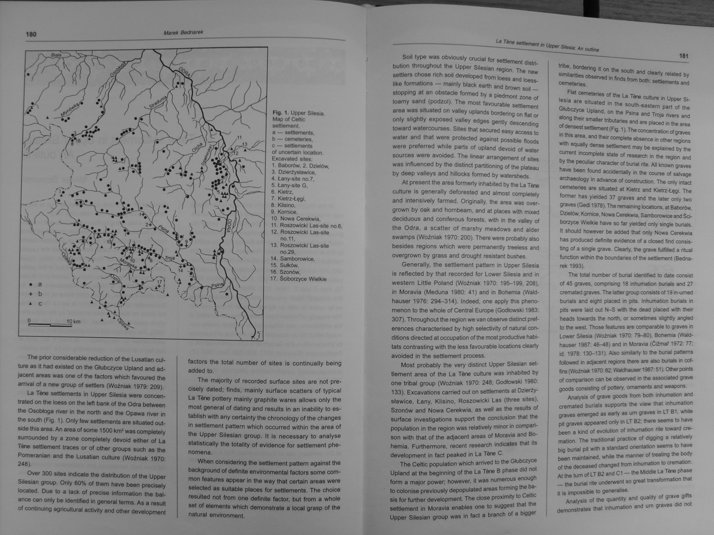
Fig. 1. Upper Silesia.
Map of Celtlc sottloment. a — settlements, b — cemeterles, c — settlements of uncertain location Excavated sites:
I. Baborów, 2. Dzielów,
3. Dzlerżysławice,
4. Łany-site no.7,
5. Łany-site G,
6. Kietrz,
7. Kletrz-Łęgi,
8. Kllsino,
9. Komice,
10. Nowa Cerekwią,
II. Roszowlckl Las-site no.6,
12. Roszowlckl Las-site no.11,
13. Roszowicki Las-site no.29,
14. Samborowice,
15. Sułków,
16. Szonów.
17. Ściborzyce Wielkie
The prior considerable reduction of the Lusatian cul-ture as it had existed on the Głubczyce Upland and ad-jacent areas was one of the factors which favoured the arrival of a new group of setUers (Woźniak 1979: 209).
La Tene settlements in Upper Silesia were concen-trated on the loess on the left bank of the Odra between the Osobłoga river in the north and the Opawa river in the south (Fig. 1). Only few settlements are situated out-side this area. An area of some 1500 km2 was completely surrounded by a zonę completely devoid either of La Tśne settlement traces or of other groups such as the Pomeranian and the Lusatian culture (Woźniak 1970: 248).
Over 300 sites indicate the distribution of the Upper Silesian group. Only 60% of them have been precisely located. Oue to a lack of precise Information the bal-ance can only be kjentified in generał terms. As a result of continuing agricultural actiwty and other development factors the total number of sites is continually being added to.
The majority of recorded surface sites are not precisely dated; finds, mainly surface scatters of typical La Tćne pottery mainly graphite wares allows only the most generał of dating and results in an inability to es-tablish with any certainty the chronology of the changes in settlement pattem which occurred within the area of the Upper Silesian group. It Is necessary to analyse statistically the totality of evidence for settlement phe-nomena.
When considering the settlement pattern against the background of definlte environmental factors some com-mon features appear In the way that certaln areas were selected as sultable places for settlements. The choice resulted not from one definlte factor, but from a whole set of elements which demonstrate a local grasp of the natural environment.
Soli type was obviously crucial for settlement distri-bution throughout the Upper Silesian region. The new settlers chose rich soil developed from loess and loess-like formations — mainly black earth and brown soil — stopping at an obstacle formed by a piedmont zonę of loamy sand (podzol). The most favourable settlement area was situated on valley uplands bordering on fiat or only slightly exposed valley edges gently descending toward watercourses. Sites that secured easy access to water and that were protected against possible floods were preferred while parts of upland devoid of water sources were avoided. The iinear arrangement of sites was influenced by the distinct partitioning of the plateau by deep valleys and hillocks formed by watersheds.
At present the area formerly inhabited by the La Tene culture is generally deforested and almost completely and intensively farmed. Originally, the area was over-grown by oak and hombeam, and at ptaces with mbced deciduous and coniferous forests, with in the valley of the Odra, a scatter of marshy meadows and alder swamps (Woźniak 1970:200). There were probably also besides regions which were permanently treeless and overgrown by grass and drought resistant bushes.
Generally, the settlement pattem in Upper Silesia is reflected by that recorded for Lower Silesia and in western Little Poland (Woźniak 1970: 195-199, 208), in Moravia (Meduna 1980: 41) and in Bohemia (Wald-hauser 1976: 294-314). Indeed, one apply this pheno-menon to the whole of Central Europę (Godłowski 1983: 307). Throughout the region we van observe distinct pref-erences characterised by high selectivrty of natural con-ditions directed at occupation of the most producth/e habi-tats contrasting with the less favourabłe locations deariy avoided in the settlement process.
Most probably the very distinct Upper Silesian set-tlement area of the La Tene culture was inhabited by one trlbal group (Woźniak 1970: 248; Godłowski 1980: 133). Excavab'ons carried out on settlements at Dzierży-sławice. Łany, Klisino, Roszowicki Las (three sites). Szonów and Nowa Cerekwią, as well as the results of surface investigations support the condusion that the population in the region was relatively minor in compari-son with that of the adjacent areas of Moravia and Bohemia. Furthermore. recent research indicates that its development in fact peaked in La Tśne C.
The Celtic population which arrived to the Głubczyce Upland at the beginning of the La Tśne B phase did not form a major po wen however. it was numerous enough to colonise previously depopulated areas forming the ba-sis for further development. The dose proximity to Celtic settlement In Moreyia enables one to suggest that the Upper Silesian group was in fad a branch of a bigger
tribe, bordering it on the south and deariy related by similarities observed in finds from both: settlements and cemeteries.
Fiat cemeteries of the La Tśne culture in Upper Silesia are situated in the south-eastem part of the Głubczyce Upland, on the Psina and Troja rivers and along their smaller tributaries and are placed in the area of densest settlement (Fig. 1). The concentration of graves in this area. and their complete absence in other regions with equally dense settlement may be explained by the current incomplete State of research in the region and by the peculiar chara eter of burial rite. Ali known graves have been found acddentaly in the course of sahrage archaeology in advance of construdion. The only intad cemeteries are situated at Kietrz and Kietrz-Łęgi. The former has yielded 37 graves and the later only two graves (Gedl 1978). The remaining locations. at Baborów, Dzietów, Komice. Nowa Cerekwią, Samborowice and Ściborzyce Wielkie have so far yielded only single burials. It should however be added that only Nowa Cerekwią has produced definite evidence of a dosed find consis-ting of a single grave. deariy. the grave fulfilled a ritual function within the boundaries of the settlement (Bednarek 1993).
The total number of burial identified to datę consist of 45 graves, comprising 18 inhumation burials and 27 cremated graves. The latter group consists of 19 in-umed burials and eight placed in pits. Inhumation burials in pits were laid out N-S with the dead placed with their heads towards the north. or some limes slightly angled to the wesL Those features are comparable to graves in Lower Silesia (Woźniak 1970: 79-80), Bohemia (Wald-hauser 1987: 46-48) and in Moravia (Ćiżmar 1972: 77; id. 1978:130-131). Also similarły to the burial pattems followed in adjacent regions there are also burials in cof-fins (Woźniak 1970:82; Waldhauser 1987:51). Other points of comparison can be obsenred in the assotiated grave goods consjstmg of pottery, omaments and weapons.
Analysis of grave goods from both inhumation and cremated burials supports the view that inhumation graves emerged as early as um graves in LT B1, while pit graves appeared only in LT B2; there seems to have been a kind of evolution of inhumation rite toward cre-mation. The traditional practice of digging a relatively big burial pit with a standard orientation seems to have been maintained. while the manner of treating the body of the deceased changed from inhumation to cremation. At the tum of LT B2 and C1 — the Middle La Tśne phase — the burial rite underwent so great transformation that it is impossible to generalise.
Analysis of the quantity and quality of grave gifts demonstrates that inhumation and um graves did not
Wyszukiwarka
Podobne podstrony:
S5006671 180 Marek Bednarek 180 Marek Bednarek i Fig. 1. Upper Silesia. Map of Ceitic setflement&nbs
S5006673 182 Marek Bednarek Flfl. 2. RoszowickJ Las. site no. 6. Hand-made pottery from the settleme
Przegląd Geologiczny, vol. 55, nr 12/1, 2007 Fig. 13. Schematic map of oil and gas fields in the Car
Fig. 25 General Map of Dixence and Mauvoisin Carte gćnćrale de Dixence et Mauvoisin 45 m3/sec. The t
Fig. 1. Geological-structural map of the eastern part of Polish Carpathians (modified, based on Żytk
56267 S5006670 La Tene settlement in Upper Silesia:An outline Marek Bednarek At the beginning of the
Geomorphological — improvement Map of the Upper Silesian Industrial District. 1 : 50,000 (manuscript
więcej podobnych podstron