2949775847
Land value map as a source of information about local real estate market 69
Another group of value maps are object maps. Art area under study is divided into zones which are uniform in terms of the assumed criteria. For each zonę, an analysis pro-vides a unit value of the land. The finał borderlines are significantly affected by the adopted criteria of isolating the uniform areas, which indicate the use of either an attributive or model approach. In the model approach, the establishing of areas borderlines is preceded by a market analysis, which results in establishing the market characteristics affecting the land value. Based on the selected market characteristics, the borderlines of the isolated zones are established, whereas the land value within the zonę are estimated with the use of the value model, produced by the analysis. In the case of the attribute approach, the marking out of the borderlines is based on the selected attributes (features) of land real estate, with the bor-ders adjusted after taking into account the road limits, water courses, railways, borders of urban blocks (uniform build-up) and the borders of areas and residential areas. A map is based on the assumption that isolated zones contain real estates with similar attributes, and consequently, their unit value should be similar.
Part of the work on the drawing up of land value maps consists in developing a method of isolating the zones of uniform real estate, based on the attributive approach. One of the arguments in favour of adopting this approach for further analyses is the diffi-culty in determining the stable statistical models which would show the effect of particular factors on transaction prices. A generał diagram of the concept of drawing up a land value map in the attributive approach is shown in Figurę 5.
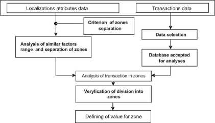
Fig. 5. A generał diagram of the concept of drawing up a land value map in the attributive approach Source: own study
The authors of the present study propose that a map of the value of land, buildings and flats should be based on a numerical cadastral 1:5000 map and generated to smaller scales down to the areas of a commune, county and province. The scope of the study should in-clude separately each commune, within the boundaries of the evidence limits. A commune is in this case the basie unit of the study.
Wyszukiwarka
Podobne podstrony:
73 Land value map as a source of information about local real estate marketReferences [1]
65 Land value map as a source of information about local real estate market tion was used to determi
Land value map as a source of information about local real estate market 67 The effect of these fact
Land value map as a source of information about local real estate market 71 Several factors had to b
186 Maciej TokarskiFinancial Statements is the Imperfect Sourceof the Information about Financial Si
JPRS-EER-91-053 2S April 1991ECONOMIC 35 Maritsa-Iztok as a source of energy, construction of the nu
Classroom language 1 IN THE CLASSROOM The classroom is often overlooked as a source of ‘authentic’ c
INYESTMENT ACTIVITY OF THE INSTITUTIONAL IIWESTORS ON THE REAL ESTATE MARKETSumma ry Tlie aniele ane
GEODEZJA • TOM 11 • Zeszyt 1/1 • 2005 Sabina Źróbek1, Radosław Cellmer1, Jan Kuryj1 LAND VALUE MAP A
Dear reader, The lack of sufficient and independent information about when and how to renovate is of
EPIA 2011 ISBN: 978-989-95618-4-7 no information about the cards of the player when they folded the
128 Agata Borowska-PietrzakPersonnel audit as a tool of personnel information system The effectivene
64 S. Źróbek, R. Cellmer, J. Kuryj2. An analysis of factors affecting the spatial differentiation of
70 S. Źróbek, R. Cellmer, J. Kuryj The following were the basis for the land value map: —
UHAM012 Preface This book should, I hope, be a useful source of Information for two groups of people
Host cache. MySQL now provides morę information about the causes of errors that occur when clients c
więcej podobnych podstron