
Enroute - Communications
RADIO FREQUENCIES
Frequencies for radio communications are included above NAVAID names, when voice is available
through the NAVAID. These frequencies are also shown at other remoted locations. Radio
Frequencies, which are in the 120 MHz range, are shown with the numbers "12" omitted; 122.2 is
shown as 2.2, 122.35 as 2.35, etc. HF and LF frequencies are not abbreviated.
River Radio transmits on 114.6 and transmits and receives on 122.2, 122.45 MHZ and HF frequency
5680.
indicates single side band not available.
River Radio (RIV) guards (receives) on 122.1 and transmits through Canyon VOR on 113.9.
River Radio transmits and receives on 122.6 located at Diamond. Small circle enclosing dot denotes
remote communication site.
Tapeats Radio transmits and receives on 122.2 and 122.4. Telephone symbol indicates additional
frequencies in communications panel listed under Tapeats.
HIWAS - Hazardous lnfliqht Weather Advisory Service. Broadcasts SIGMETS, AIRMETS and
PIREPS continuously over VOR frequency.
River Radio transmits and receives at Phantom on 122.3. Additionally, Phantom Radio transmits and
receives on 122.6.
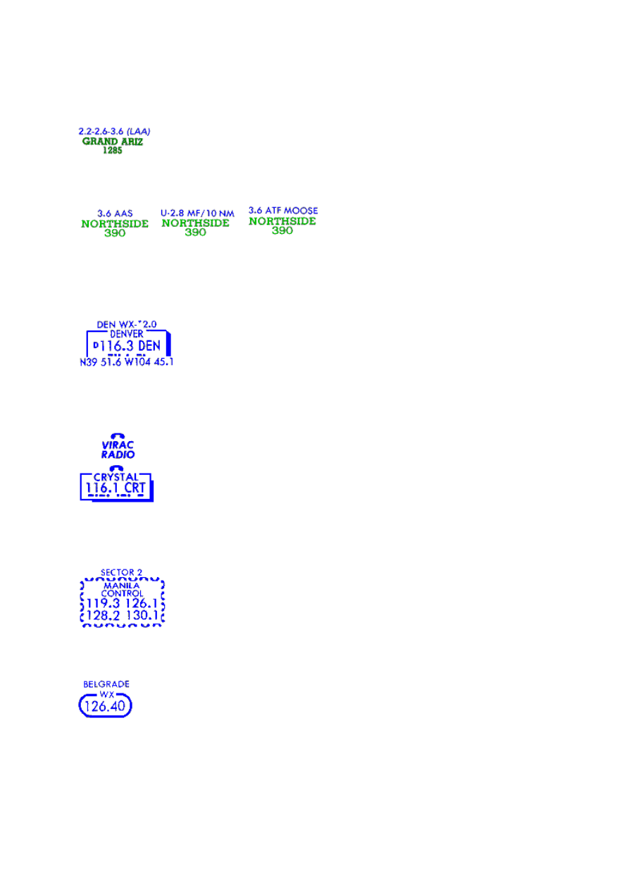
River Radio transmits through Lava VOR on 115.3, but is not capable of receiving transmissions
through the VOR site.
Grand Radio is located at the airport and transmits and receives on 122.2 and 122.6. Additionally,
Grand Radio provides LAA (Local Airport Advisory) on 123.6.
Terminal Radio frequencies and service may be included over airport or location name. Radio call is
included when different than airport or location name. Mandatory Frequencies (MF), Aerodrome
Traffic Frequencies (ATF) or UNICOM (U) frequencies include contact distance when other than the
standard 5 nm.
US "Enroute Flight Advisory Service". Ident of controlling station to call, using (name of station)
FLIGHT WATCH on 122.0 MHz. Charted above VORs associated with controlling station and
remoted outlets. Service is provided between 0600 and 2200 hours daily.
The telephone symbol indicates additional communications may be found in the communications
tabulation after the associated NAVAID or location name. Telephone symbol does not
necessarily mean that voice is available through the NAVAID.
Call and frequencies of Control Service for use within graphically portrayed Radio Frequency Sector
Boundaries.
Plain language inflight weather station with name and frequency.
Call and frequencies of control or unit service. For use within geographical defined radio boundaries.
Call and frequency of enroute service or control unit. SINGLE SIDE BAND capabilities are available
unless specified otherwise.
Remote air/ground antenna for direct communications with control center. Center is named in large
type and name of remote site is in parentheses below followed by appropriate VHF frequencies.
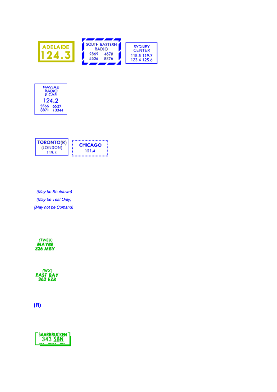
NAVAID/COMMUNICATION DATA
Operational status at date of publication. Refer to Chart NOTAMS for current status, including
substitute routes for VOR and VORTAC shutdowns.
(TWEB) indicates continuous automatic weather broadcast is provided on the facility frequency.
Class SABH radio beacons of limited navigation suitability indicate their primary purpose of
continuous automatic weather broadcast by (WX).
Enroute Radar capability. (All domestic U.S. centers are radar equipped so (R) is omitted from
domestic U.S. center boxes.)
Underline shown below navaid identifier, indicates Beat Frequency Oscillator (BFO) required to hear

Morse Code identifier.
Asterisk indicates navaid operation or service not continuous.
Marine beacon operation times. Transmission begins at 4 minutes past the hour and every 15
minutes thereafter in this illustration; other times will be indicated. Number in parentheses gives
duration in minutes of transmission.
Facility operates in fog only at times indicated.
Wyszukiwarka
Podobne podstrony:
Printing Airports Enroute
Printing Navaids Enroute
Printing Boundaries and Airspace Enroute
Printing High Altitude Charts Enroute
Printing General Information Enroute
Printing Airway and Route Components Enroute
Printing Restricted Airspace Enroute
(ebook PDF)Shannon A Mathematical Theory Of Communication RXK2WIS2ZEJTDZ75G7VI3OC6ZO2P57GO3E27QNQ
Printing bbjorgos lekcja41 uzupelnienie A
Printing bbjorgos lekcja01 05 A
Printing Komputery i informatyka A
Printing Spojniki A
Printing bbjorgos lekcja11 15 A
Printing bbjorgos lekcja21 25 B
Printing Dane osobiste A
Printing Przymiotniki cech przedmiotow zjawisk procesow B
Ens commune
Printing Podroz A
więcej podobnych podstron