
W al
k &
C
ycl
e
SO
UT
H W
ES
T W
IR
RA
L
A pleasant walk along the coast and then inland
up through Dungeon Wood with its waterfalls
and ancient woodland. The rise in height to one
of the highest points Wirral near Oldfield Farm
gives magnificent views over the River Dee to
Wales before returning through Heswall Dales
to the shoreline. Why not take a picnic for a
detour to the Thurstaston Visitor Centre which
is part of the Wirral Country Park and make a
day of it.
Start: Banks Road, Heswall. (Sheldrakes Restaurant
situated at the end of Banks Road, where walkers are
welcome to use their facilities during their normal
opening hours. They are hoping to offer 3 other shorter
alternative walks available from the restaurant.
Distance: 4 - 5 miles, 2 - 6 hours, including a detour to
Thurstaston Visitor Centre.
Parking: Free large car park at the start/finish.
Buses and Trains: Bus stops are located within Lower
Heswall. Heswall Railway Station is just over
2 miles away.
Start at Banks Road Car Park and walk up Banks
Road with Sheldrakes and the coast behind you. When
Banks Road bends to the right, turn left into Broad Lane.
Continue along Broad Lane. Look out for wildlife in
the hedgerows and a variety of trees, wildflowers and birds.
When you see Target Road on the left you can, as an
alternative, follow this bridleway to the beach (sometimes
difficult at very high tides). (See picture below left). Other
than at high tide follow the beach a short distance to the
stream and then climb up the steps to point .
By continuing along Broad Lane: at the end of the
lane before the driveway of the large white house, go
through the gap next to the middle gate and walk to the
end of the field.
Turn left and go through a kissing gate, then a pinch
gap onto Heswall Fields. This area is owned by the National
Trust, and if you have brought a picnic it is a great place to
stop and enjoy the views. Listen for calls of the estuary birds
that feed along the shoreline particularly the ‘peep’ call of
Oystercatchers.
At the cliff top turn right and follow the cliff along
and then keeping the hedges on your left. Aim for the
National Trust sign in the far right hand corner of the
field, past the pond and walk up the path to meet the
Wirral Way. The first track is the cycle/bridle route but
take the next left onto the footpath of the Wirral Way.
Here you can carry on up the Wirral Way to
Thurstaston Visitor Centre, part of Wirral Country
Park, returning the same way, (an extra mile in total).
or
Take the path to Dungeon Wood on the right, onto
footpath 72. ‘Dungeon’ is Old English for wooded dell.
Follow the path
until you see a small
bridge on your left,
cross it and walk up
the steep steps, then
bear right along the
edge of the dell. Pass
the waterfall on your
right, the path then
crosses the stream
eventually meeting the
path that runs between
Thurstaston and
Heswall.
Turn right and follow the path to Oldfield Farm,
past the farm to Oldfield Road. This area has great
views over the Dee to Wales and is close to the highest
point in Wirral.
Walk along Oldfield Road until you reach the
entrance track to Heswall Dales on your right.
Walk down the track and follow it left. At the
Rangers House keep left to the information board.
Follow this permissive bridleway along its obvious
course turning right and then ever downwards to the
road known as Bushway, where you turn right along
this short cul-de-sac.
Turn left at the end of Bushway onto Pipers Lane,
then turn right into Delavor Road, over the bridge and
follow the road round to the right. This is Banks Road,
therefore follow it round to the left returning to the car
park, the coast and Sheldrakes.
WALK 3 Heswall Dales & Fields
Starting and finishing at Wirral Country Park,
this route follows the predominantly off road
Wirral Way to Parkgate where you can enjoy
views across the Gayton Sands Reserve to
North Wales.
Start: Wirral Way - at Wirral Country Park,
Station Road, Thurstaston
Distance: 7.5 miles
With the car park behind you, head off to the left
down the Wirral Way towards Heswall. This section of
the route continues for approximately 2 miles, off road
and is relatively flat for easy cycling. After which, the
Wirral Way trail comes to a brief end and it joins a
residential road, Davenport Road.
Continue along Davenport Road, past Bromley Close
and Station Road to where the road bends around to
the right at Riverbank Road. At this bend, you will see
a wooden signpost that directs you back onto the off
road section of the Wirral Way again.
The route continues along the Wirral Way and
through Heswall Golf Course for a little over a mile
where you will come to the junction with Boathouse
Lane. Boathouse Lane can be busy so extra care should
be taken here.
Make a right turn onto Boathouse Lane and follow
the road down towards The Parade. Again, The Parade
can be very busy with traffic, particularly on sunny
days so do take care. The parade has many eating
establishments along it and is a good place to rest
and enjoy the view.
Continuing along The Parade, you will pass Mostyn
House School and shortly after, the road bends around to
the left. Follow it around the bend and continue up Station
Road for about 0.3miles where you will see a sign on your
left that leads you back onto the Wirral Way.
Make a left turn off Station Road onto the Wirral Way
and head back on yourself towards Heswall again. This
section of the Wirral Way is often plagued by potholes so
be aware you may be in for a bumpy ride! If you want to
avoid this, you can of course head back along The Parade
to Boathouse Lane and rejoin the Wirral Way where you
left it earlier.
After about half a mile you will come to the junction
with Boathouse Lane. Cross the road and continue
straight on along the Wirral Way for the 3 miles
(approximately) back to Thurstaston.
CYCLE 1 South West Cycle Route
ww
w .v
isi
tw
irr
al.
co
m/
coa
st&
cou
ntr
ysi
de
Heswall
Banks
Road
Poll
Hill
Dungeon
Wood
Heswall
Dales
Local Nature
Reserve
Alternative route
sometimes difficult
at very high tides
Heswall Fields
(National Trust)
Tar
get
Rd
W
IR
R
A
L
W
A
Y
P
ip
er
s L
an
e
O
ld
fi
eld
W
ay
O
ld
fi
el
d
R
oa
d
Old
field
Drive
T
ele
g
ra
ph
R
oa
d
O
ld
fi
el
d
D
ri
ve
B
ro
ad
L
an
e
R
d
Bushway
to
Church Farm
&
Thurstaston
>
to
Thurstaston
Visitor Centre
>
T
ele
g
ra
p
h
R
d
T
h
ur
st
as
to
n
R
d
P
ip
er
s
L
an
e
Oldfield
Farm
Sheldrakes
Restaurant
White
House
stile &
pinch
gap
seat
seat
seat
steps
steps
bridge
bridge
seat waterfall
stile
stile
stile
gap
pinch
gap
pinch
gap
pinch
gap
pinch
gap
Dela
vor
Start & Finish
1
2
3
4
5
6
7
8
9
10
11
12
2a
B
R
39
BR
40
BW 31
FP71
FP
70
FP
7
0
FP32
BW 37
FP
34
FP
4
3
FP72
B
W
4
2
WALK 3 Heswall Dales & Fields map
CYCLE 1 South West Cycle Route map
The beach at the end of Target Road.
Dungeon Wood
1
2
3
4
5
6
7
1
2
3
4
5
6
7
8
9
10
11
12
2a
5
ST
AT
IO
N
R
O
A
D
ST
AT
IO
N
R
O
A
D
Slipw
ay
Access to
beach
Steps to
beach
Steps to
beach
Dungeon
Bridge
Station Road
Bridge
TE
LE
GR
AP
H R
OA
D
to West Kirby
<
to Heswall
<
Thurstaston
Tinkers
Dell
St Bartholomew’s
Church
Caldy
Golf Course
Dee Sailing
Club
Shore
Cottage
Cottage Loaf
Thurstaston
Centre
W
IR
R
A
L W
AY
W
IR
R
A
L W
AY
Dee Cliffs
Thurstaston Visitor Centre
Heswall
Poll
Hill
Dungeon
Wood
Heswall
Dales
Local Nature
Reserve
Heswall Fields
(National Trust)
W
IR
R
A
L
W
A
Y
P
ip
er
s L
an
e
O
ld
fi
eld
W
ay
O
ld
fi
el
d
R
oa
d
T
ele
g
ra
ph
R
oa
d
A
54
0
R
oa
d
to Thurstaston
>
Wirral
Country Park
& Thurstaston
Visitor Centre
T
ele
g
ra
p
h
R
d
T
h
ur
st
as
to
n
R
d
P
ip
er
s
L
an
e
Oldfield
Farm
Sheldrakes
Restaurant
White
House
Dela
vor
Station R
oad
Church
Farm
Tesco
Banks
Road
Seaban
k Road
Heswall
The
Beacons
Park We
st
D
av
en
p
o
rt
R
o
a
d
2
1
Start & Finish
W
Parkgate
Gayton
W
IR
R
A
L
W
A
Y
W
IR
R
A
L
W
A
Y
ACCESS TO
WIRRAL WAY
Golf Course
Golf Course
Backwood
Hall Farm
Playing
Field
The
Boathouse
Inn
Gayton Sands RSPB
Nature Reserve
Boathouse L
ane
Golf
Club
House
Boat
hous
e La
ne
windbl
own tre
es
Gayton
well
T
h
e
P
ar
ad
e
Bevyl Road
Brooklands Rd
Cott
age
Lan
e
W
ell
L
an
e
Gayton
Farm Road
Station R
oad
W
o
o
d
L
an
e
L
ei
g
h
to
n
R
o
ad
CY
CL
E
RO
UT
E
56
W
IR
R
A
L
W
A
Y
Seaban
k Road
Riverb
ank Ro
ad
Heswall
The
Beacons
Park We
s
D
av
en
p
o
rt
R
o
a
d
3
4
5
6
7
WIRRAL
CHESHIR
E WEST
& CHEST
ER
THURSTASTON VISITOR CENTRE
Map
Map 1
(North)
Map 2
(South)
Countryside code
From a gentle stroll or relaxing picnic to a long-
distance walk or heart-pumping adventure, the
countryside provides every opportunity for
enjoyment and relaxation.
If you follow the Countryside Code wherever you go,
you will get the best enjoyment possible and you will
help to protect the countryside now and for future
generations.
• Be safe - plan ahead and follow any signs.
• Leave gates and property as you find them.
• Protect plants and animals, and take your
litter home.
• Keep dogs under close control.
• Consider other people.
Cycle safety
• Before each journey spend a few minutes
ensuring that your bike is in good working
order, paying particular attention to brakes,
tyres and the steering system.
• Wear bright clothing and a cycle helmet.
At night front and rear lights and a red rear
reflector are legally required and get you seen.
• When riding on roads always follow the
Highway Code.
© Crown copyright and database rights 2013 Ordnance Survey 100019803. You are not permitted to copy, sub-license, distribute or sell any of this data to third parties in any form.
Suggested walk route
Footpath
Bridleway
Byway
Footpath
Bridleway
Cyclepath and part of Wirral Circula
Public rights of way number
Railway station
Residential
Country parks/public open spaces
Rivers/streams
Accessible ponds
Bus stops
Car park
Public houses
Cafe
Toilets
Kiosk
Viewpoint
Information
Picnic site
Church
Wirral Circular Trail
Wirral Council boundary
FP1
Public Rights of Way:
Permissive Routes:
KIOSK
Key
Suggested cycle route
Cyclepath
Railway station
Residential
Country parks/public open spaces
Rivers/streams
Accessible ponds
Car park
Public houses
Cafe
Toilets
Kiosk
Viewpoint
Information
Picnic site
Church
Wirral Circular Trail
Wirral Council boundary
KIOSK
Key
Wirral Country Park
© Crown copyright and database rights 2013 Ordnance Survey 100019803. You are not permitted to copy, sub-license, distribute or sell any of this data to third parties in any form.
© Crown copyright and database rights 2013 Ordnance Survey 100019803. You are not permitted to copy, sub-license, distribute or sell any of this data to third parties in any form.
Approx. 10-15 minutes walk
mile
0
½
Km
0
1
0.5
Approx. 10-15 minutes walk
mile
0
½
Km
0
1
0.5
Km
Approx. 10-15 minutes walk
mile
0
0
1
½
0.5
A
M53
WIRRAL
M53
WIRRAL
679Nov11SK
Du
ng
eon
W
ood
-
W al
k 3
W al
k &
C
ycl
e
SO
UT
H W
ES
T W
IR
RA
L
A pleasant walk along the coast and then inland
up through Dungeon Wood with its waterfalls
and ancient woodland. The rise in height to one
of the highest points Wirral near Oldfield Farm
gives magnificent views over the River Dee to
Wales before returning through Heswall Dales
to the shoreline. Why not take a picnic for a
detour to the Thurstaston Visitor Centre which
is part of the Wirral Country Park and make a
day of it.
Start: Banks Road, Heswall. (Sheldrakes Restaurant
situated at the end of Banks Road, where walkers are
welcome to use their facilities during their normal
opening hours. They are hoping to offer 3 other shorter
alternative walks available from the restaurant.
Distance: 4 - 5 miles, 2 - 6 hours, including a detour to
Thurstaston Visitor Centre.
Parking: Free large car park at the start/finish.
Buses and Trains: Bus stops are located within Lower
Heswall. Heswall Railway Station is just over
2 miles away.
Start at Banks Road Car Park and walk up Banks
Road with Sheldrakes and the coast behind you. When
Banks Road bends to the right, turn left into Broad Lane.
Continue along Broad Lane. Look out for wildlife in
the hedgerows and a variety of trees, wildflowers and birds.
When you see Target Road on the left you can, as an
alternative, follow this bridleway to the beach (sometimes
difficult at very high tides). (See picture below left). Other
than at high tide follow the beach a short distance to the
stream and then climb up the steps to point .
By continuing along Broad Lane: at the end of the
lane before the driveway of the large white house, go
through the gap next to the middle gate and walk to the
end of the field.
Turn left and go through a kissing gate, then a pinch
gap onto Heswall Fields. This area is owned by the National
Trust, and if you have brought a picnic it is a great place to
stop and enjoy the views. Listen for calls of the estuary birds
that feed along the shoreline particularly the ‘peep’ call of
Oystercatchers.
At the cliff top turn right and follow the cliff along
and then keeping the hedges on your left. Aim for the
National Trust sign in the far right hand corner of the
field, past the pond and walk up the path to meet the
Wirral Way. The first track is the cycle/bridle route but
take the next left onto the footpath of the Wirral Way.
Here you can carry on up the Wirral Way to
Thurstaston Visitor Centre, part of Wirral Country
Park, returning the same way, (an extra mile in total).
or
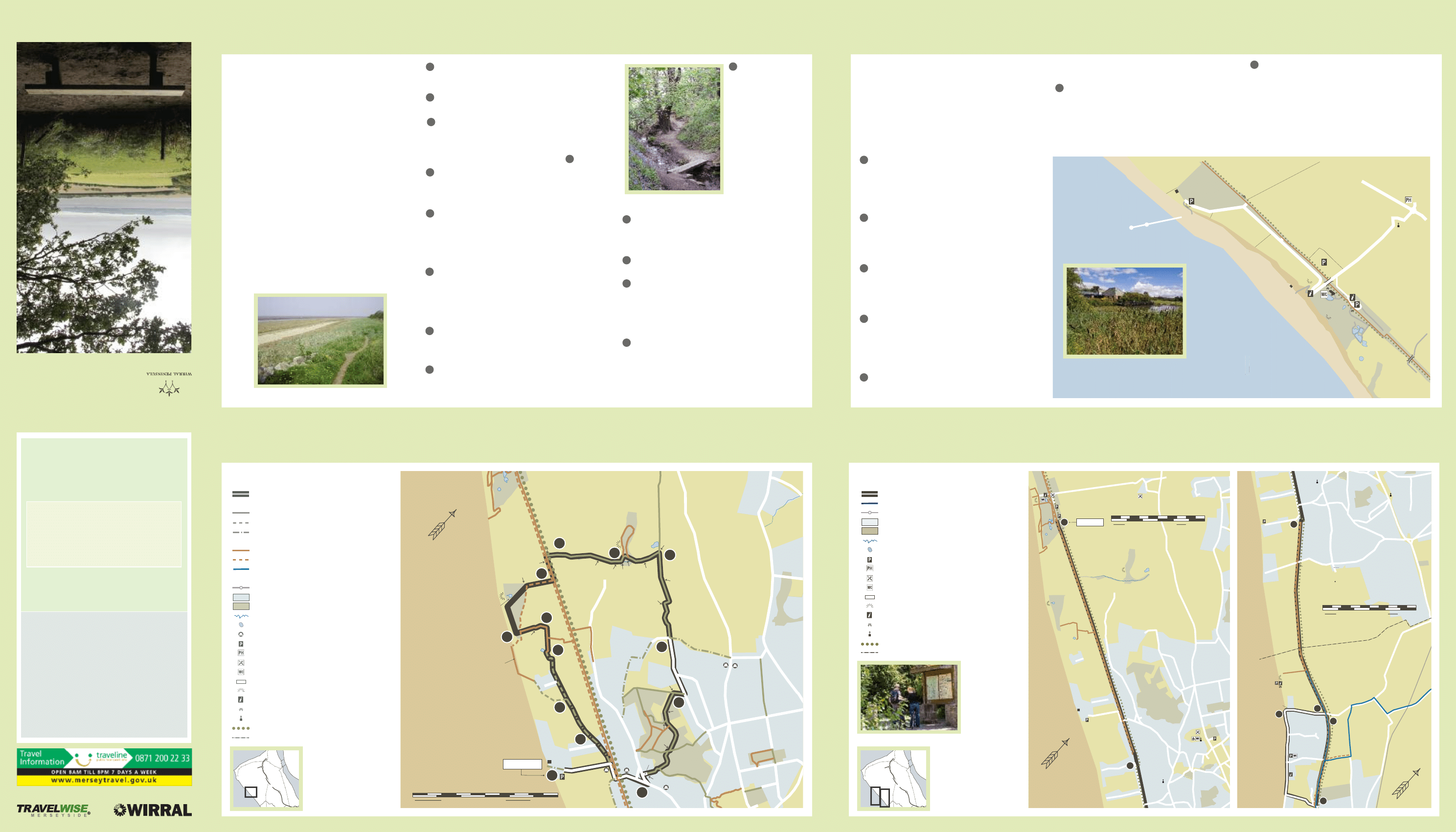
Take the path to Dungeon Wood on the right, onto
footpath 72. ‘Dungeon’ is Old English for wooded dell.
Follow the path
until you see a small
bridge on your left,
cross it and walk up
the steep steps, then
bear right along the
edge of the dell. Pass
the waterfall on your
right, the path then
crosses the stream
eventually meeting the
path that runs between
Thurstaston and
Heswall.
Turn right and follow the path to Oldfield Farm,
past the farm to Oldfield Road. This area has great
views over the Dee to Wales and is close to the highest
point in Wirral.
Walk along Oldfield Road until you reach the
entrance track to Heswall Dales on your right.
Walk down the track and follow it left. At the
Rangers House keep left to the information board.
Follow this permissive bridleway along its obvious
course turning right and then ever downwards to the
road known as Bushway, where you turn right along
this short cul-de-sac.
Turn left at the end of Bushway onto Pipers Lane,
then turn right into Delavor Road, over the bridge and
follow the road round to the right. This is Banks Road,
therefore follow it round to the left returning to the car
park, the coast and Sheldrakes.
WALK 3 Heswall Dales & Fields
Starting and finishing at Wirral Country Park,
this route follows the predominantly off road
Wirral Way to Parkgate where you can enjoy
views across the Gayton Sands Reserve to
North Wales.
Start: Wirral Way - at Wirral Country Park,
Station Road, Thurstaston
Distance: 7.5 miles
With the car park behind you, head off to the left
down the Wirral Way towards Heswall. This section of
the route continues for approximately 2 miles, off road
and is relatively flat for easy cycling. After which, the
Wirral Way trail comes to a brief end and it joins a
residential road, Davenport Road.
Continue along Davenport Road, past Bromley Close
and Station Road to where the road bends around to
the right at Riverbank Road. At this bend, you will see
a wooden signpost that directs you back onto the off
road section of the Wirral Way again.
The route continues along the Wirral Way and
through Heswall Golf Course for a little over a mile
where you will come to the junction with Boathouse
Lane. Boathouse Lane can be busy so extra care should
be taken here.
Make a right turn onto Boathouse Lane and follow
the road down towards The Parade. Again, The Parade
can be very busy with traffic, particularly on sunny
days so do take care. The parade has many eating
establishments along it and is a good place to rest
and enjoy the view.
Continuing along The Parade, you will pass Mostyn
House School and shortly after, the road bends around to
the left. Follow it around the bend and continue up Station
Road for about 0.3miles where you will see a sign on your
left that leads you back onto the Wirral Way.
Make a left turn off Station Road onto the Wirral Way
and head back on yourself towards Heswall again. This
section of the Wirral Way is often plagued by potholes so
be aware you may be in for a bumpy ride! If you want to
avoid this, you can of course head back along The Parade
to Boathouse Lane and rejoin the Wirral Way where you
left it earlier.
After about half a mile you will come to the junction
with Boathouse Lane. Cross the road and continue
straight on along the Wirral Way for the 3 miles
(approximately) back to Thurstaston.
CYCLE 1 South West Cycle Route
ww
w .v
isi
tw
irr
al.
co
m/
coa
st&
cou
ntr
ysi
de
Heswall
Banks
Road
Poll
Hill
Dungeon
Wood
Heswall
Dales
Local Nature
Reserve
Alternative route
sometimes difficult
at very high tides
Heswall Fields
(National Trust)
Tar
get
Rd
W
IR
R
A
L
W
A
Y
P
ip
er
s L
an
e
O
ld
fi
eld
W
ay
O
ld
fi
el
d
R
oa
d
Old
field
Drive
T
ele
g
ra
ph
R
oa
d
O
ld
fi
el
d
D
ri
ve
B
ro
ad
L
an
e
R
d
Bushway
to
Church Farm
&
Thurstaston
>
to
Thurstaston
Visitor Centre
>
T
ele
g
ra
p
h
R
d
T
h
ur
st
as
to
n
R
d
P
ip
er
s
L
an
e
Oldfield
Farm
Sheldrakes
Restaurant
White
House
stile &
pinch
gap
seat
seat
seat
steps
steps
bridge
bridge
seat waterfall
stile
stile
stile
gap
pinch
gap
pinch
gap
pinch
gap
pinch
gap
Dela
vor
Start & Finish
1
2
3
4
5
6
7
8
9
10
11
12
2a
B
R
39
BR
40
BW 31
FP71
FP
70
FP
7
0
FP32
BW 37
FP
34
FP
4
3
FP72
B
W
4
2
WALK 3 Heswall Dales & Fields map
CYCLE 1 South West Cycle Route map
The beach at the end of Target Road.
Dungeon Wood
1
2
3
4
5
6
7
1
2
3
4
5
6
7
8
9
10
11
12
2a
5
ST
AT
IO
N
R
O
A
D
ST
AT
IO
N
R
O
A
D
Slipw
ay
Access to
beach
Steps to
beach
Steps to
beach
Dungeon
Bridge
Station Road
Bridge
TE
LE
GR
AP
H R
OA
D
to West Kirby
<
to Heswall
<
Thurstaston
Tinkers
Dell
St Bartholomew’s
Church
Caldy
Golf Course
Dee Sailing
Club
Shore
Cottage
Cottage Loaf
Thurstaston
Centre
W
IR
R
A
L W
AY
W
IR
R
A
L W
AY
Dee Cliffs
Thurstaston Visitor Centre
Heswall
Poll
Hill
Dungeon
Wood
Heswall
Dales
Local Nature
Reserve
Heswall Fields
(National Trust)
W
IR
R
A
L
W
A
Y
P
ip
er
s L
an
e
O
ld
fi
eld
W
ay
O
ld
fi
el
d
R
oa
d
T
ele
g
ra
ph
R
oa
d
A
54
0
R
oa
d
to Thurstaston
>
Wirral
Country Park
& Thurstaston
Visitor Centre
T
ele
g
ra
p
h
R
d
T
h
ur
st
as
to
n
R
d
P
ip
er
s
L
an
e
Oldfield
Farm
Sheldrakes
Restaurant
White
House
Dela
vor
Station R
oad
Church
Farm
Tesco
Banks
Road
Seaban
k Road
Heswall
The
Beacons
Park We
st
D
av
en
p
o
rt
R
o
a
d
2
1
Start & Finish
W
Parkgate
Gayton
W
IR
R
A
L
W
A
Y
W
IR
R
A
L
W
A
Y
ACCESS TO
WIRRAL WAY
Golf Course
Golf Course
Backwood
Hall Farm
Playing
Field
The
Boathouse
Inn
Gayton Sands RSPB
Nature Reserve
Boathouse L
ane
Golf
Club
House
Boat
hous
e La
ne
windbl
own tre
es
Gayton
well
T
h
e
P
ar
ad
e
Bevyl Road
Brooklands Rd
Cott
age
Lan
e
W
ell
L
an
e
Gayton
Farm Road
Station R
oad
W
o
o
d
L
an
e
L
ei
g
h
to
n
R
o
ad
CY
CL
E
RO
UT
E
56
W
IR
R
A
L
W
A
Y
Seaban
k Road
Riverb
ank Ro
ad
Heswall
The
Beacons
Park We
s
D
av
en
p
o
rt
R
o
a
d
3
4
5
6
7
WIRRAL
CHESHIR
E WEST
& CHEST
ER
THURSTASTON VISITOR CENTRE
Map
Map 1
(North)
Map 2
(South)
Countryside code
From a gentle stroll or relaxing picnic to a long-
distance walk or heart-pumping adventure, the
countryside provides every opportunity for
enjoyment and relaxation.
If you follow the Countryside Code wherever you go,
you will get the best enjoyment possible and you will
help to protect the countryside now and for future
generations.
• Be safe - plan ahead and follow any signs.
• Leave gates and property as you find them.
• Protect plants and animals, and take your
litter home.
• Keep dogs under close control.
• Consider other people.
Cycle safety
• Before each journey spend a few minutes
ensuring that your bike is in good working
order, paying particular attention to brakes,
tyres and the steering system.
• Wear bright clothing and a cycle helmet.
At night front and rear lights and a red rear
reflector are legally required and get you seen.
• When riding on roads always follow the
Highway Code.
© Crown copyright and database rights 2013 Ordnance Survey 100019803. You are not permitted to copy, sub-license, distribute or sell any of this data to third parties in any form.
Suggested walk route
Footpath
Bridleway
Byway
Footpath
Bridleway
Cyclepath and part of Wirral Circula
Public rights of way number
Railway station
Residential
Country parks/public open spaces
Rivers/streams
Accessible ponds
Bus stops
Car park
Public houses
Cafe
Toilets
Kiosk
Viewpoint
Information
Picnic site
Church
Wirral Circular Trail
Wirral Council boundary
FP1
Public Rights of Way:
Permissive Routes:
KIOSK
Key
Suggested cycle route
Cyclepath
Railway station
Residential
Country parks/public open spaces
Rivers/streams
Accessible ponds
Car park
Public houses
Cafe
Toilets
Kiosk
Viewpoint
Information
Picnic site
Church
Wirral Circular Trail
Wirral Council boundary
KIOSK
Key
Wirral Country Park
© Crown copyright and database rights 2013 Ordnance Survey 100019803. You are not permitted to copy, sub-license, distribute or sell any of this data to third parties in any form.
© Crown copyright and database rights 2013 Ordnance Survey 100019803. You are not permitted to copy, sub-license, distribute or sell any of this data to third parties in any form.
Approx. 10-15 minutes walk
mile
0
½
Km
0
1
0.5
Approx. 10-15 minutes walk
mile
0
½
Km
0
1
0.5
Km
Approx. 10-15 minutes walk
mile
0
0
1
½
0.5
A
M53
WIRRAL
M53
WIRRAL
679Nov11SK
Du
ng
eon
W
ood
-
W al
k 3
Wyszukiwarka
Podobne podstrony:
Darnall and Tinsley Cycle Map
Marvel Super Heroes Gates of What If Castle Doom Map
map of spain
Blender 3D Materiały Texturowanie UV Map
Pathfinder Rise of the Runelords Map Counters
ZUPA KREM ZE SZPARAGÓW, - Mapa Map 7.5.2 2013 Q1
Gimnazjum, Chrzest966, MAP
Map of Planes
MERP Maps Shire Map
Marvel Super Heroes Gates of What If Underground Prison Map
Cell Cycle
Marvel Super Heroes Gates of What If AIM Facility Map
Castles & Crusades Inzae World Map
Map And Compass
Andorra mountain map
Brain Map Auditory System
Nyambe Map
więcej podobnych podstron