
INTEGRATED SPATIAL PLANNING SUPPORT SYSTEMS FOR MANAGING
URBAN SPRAWL
H. S. SUDHIRA
Research Scholar
Department of Management Studies and
Centre for Sustainable Technologies
Indian Institute of Science
Bangalore – 560 012
India
Tel: +91 80 2293 2786
Fax: +91 80 2360 4534
E-mail:
sudhira@mgmt.iisc.ernet.in
T. V. RAMACHANDRA
Associate Faculty
Centre for Sustainable Technologies and
Centre for Ecological Sciences
Indian Institute of Science
Bangalore – 560 012
India
Tel: +91 80 2293 3099
Fax: +91 80 2360 1428
E-mail:
cestvr@ces.iisc.ernet.in
M. H. BALA SUBRAHMANYA
Associate Professor
Department of Management Studies
Indian Institute of Science
Bangalore – 560 012
India
Tel: +91 80 2293 3066
Fax: +91 80 2360 4534
E-mail:
bala@mgmt.iisc.ernet.in
Abstract: The paper addresses the issues and problems that concerns managing
urban sprawl in India. Three essential steps to strengthen policy, planning and
decision making are outlined while identifying the gaps. In India, as per constitutional
provisions, there is a mandate with urban local bodies for administering, managing
and preparing master / development plans. Mostly these plans are static maps with
limited forecasting capabilities and there is a dearth of models for planning process
and hence leading to ad hoc decisions. Besides this, these plans mostly restrict to
demarcate only land use zones with little or no effective regulation for the same.
Further, with planning authorities restricting to mostly land uses, there is hardly any
coordinated effort to involve or integrate transport, water and sanitation, etc. in the
planning process. This results in organisations involved or catering to different
services (transport, health, water, energy, etc.) work in isolation to address basic
amenities. Lack of coordination among many agencies has lead to unsustainable use
of land and other resources and also uncoordinated urban growth. Urban governance
and administration requires keeping track of various processes, activities, services
and functions of the urban local body, which is possible through an information
system. In the absence of any such systems, at the basic level, there is a strong and
pressing need for an information system to cater to all these. In the next level, it
becomes essential to build models based on the information systems involving
simulation and analysis for specific urban contexts. The subsequent level involves
evolving different strategy and policy options using the models and information
systems. Thus, at the outset, there are three essential steps to address the problem
of sprawl and to strengthen planning and decision making – information systems,
models and policies. Review of the different geospatial modelling techniques
(operations research, system dynamics, geospatial, agent-based, etc.) being used in
the urban context highlights the increased dependence on geo-based models and
also the need for an integrated spatial planning support system.
Keywords: urban sprawl, modelling, planning support systems
Reviewed Paper

Paper 199
2
1. URBAN SPRAWL: THE INDIAN EXPERIENCE
Urban sprawl is the outgrowth along the periphery of cities and along highways.
Although accurate definition of urban sprawl may be debated, a general consensus is
that urban sprawl is characterized by an unplanned and uneven pattern of growth,
driven by multitude of processes and leading to inefficient resource utilization.
Urbanisation in India has been never as rapid as it is in the recent times. As one of
the fastest growing economies in the world, India faces stiff challenges in managing
this urban growth leading to sprawl and ensuring effective delivery of basic services
in urban areas.
Urban growth, as such is a continuously evolving natural process due to population
growth rates (birth and death). An increased urban population and growth in urban
areas is inadvertent with an unpremeditated population growth and migration. In India,
urban population is currently growing at around 2.3 percent per annum. The number
of urban agglomerations and towns in India has increased from 3697 in 1991 to 4369
in 2001. It is projected that the country’s urban population would increase from 28.3
percent in 2003 to about 41.4 percent by 2030 (United Nations, 2004). By 2001,
there were 35 urban agglomerations / cities having a population of more than one
million from 25 urban agglomerations in 1991. Of the 4000 plus urban
agglomerations, about 38 percent reside in just 35 urban areas, thus indicating the
magnitude of urbanisation prevailing in the country. This clearly indicates the
magnitude of concentrated growth and urban primacy, which also has lead to urban
sprawl.
The urban areas contribute significantly to the national economy (about … percent of
GDP), while facing critical challenges in accessing basic services and necessary
infrastructure, both social and economic. The overall rise in population of urban poor
or increase in travel times owing to congestion in road networks are indicators of the
effectiveness of planning and administration in assessing and catering to the demand.
Thus the administration at all levels: local bodies, state government and federal
government, are facing the brunt of this rapid urban growth. It is imperative for
planning and administration to facilitate, augment and service the requisite
infrastructure over time systematically. Provision of infrastructure and ensuring
delivery of basic services cannot happen overnight and hence planning has to
facilitate in forecasting and provisioning these services with appropriate mechanisms.
This paper addresses the sprawl in the Indian context. The subsequent section
analyses the status of planning practices in India with emphasis on utility of spatial
planning tools and an overview of the institutional dynamics contributing to sprawl. As
a synthesis of the prevailing situation analysis the ensuing section brings about the
critical challenges for addressing sprawl. Finally the paper concludes highlighting the
need for an integrated spatial planning support system suggesting a framework
demonstrating rudimentary simulations for managing urban sprawl.
1.1 Urban Sprawl: Pattern, Process, Causes and Consequences
Earlier studies characterise urban sprawl (Barnes et al., 2001; Hurd et al., 2001;
Epstein et al., 2002; Sudhira et al., 2004b) using spatial metrics while highlighting the
implications of sprawl on natural resources and how inefficient the unplanned growth
could be. Among the undesirable effects of sprawl are unplanned outgrowths, which
are not aesthetic and sprang in an unhygienic manner. Thus, there have been varied
connotations to ascribe what constitutes sprawl. Galster et al. (2001) have addressed
this issue as ‘lost in semantic wilderness’, by describing the sprawl under six broad

Paper 199
3
categories:
a) By example that embodies characteristics of sprawl, such as Los Angeles
b) Aesthetic judgement and general development pattern
c) Cause of an externality
d) Consequence or effect independent variables
e) Pattern of development
f) Process of development
Extending Torrens and Alberti (2000)’s notion of urban sprawl Galster et al. (2001)
defines it as a pattern of land use in an urban agglomeration that exhibits low levels
of some combination of eight distinct dimensions: density, continuity, concentration,
clustering, centrality, nuclearity, mixed uses and proximity. Ascribing sprawl as a
pattern of land use alone would not throw light on the underlying processes, causes
and hence consequences. In a developing country like India, where population
density is high with significant urbanization rates, urban sprawl obviously cannot be
characterised by pattern alone but processes, causes and their consequences.
Hence, we suggest a modification to the definition of urban sprawl as the pattern of
outgrowth emergent during the process of urban spatial expansion over time caused
by some externalities and a consequence of local planning and administration.
Hence, characterizing urban sprawl can only be achieved by acknowledging the
complexity of urban systems and capturing these in different dimensions.
Apart from the eight distinct dimensions suggested by Galstner et al. (2001), the
pattern of outgrowth is also captured by the spatial metrics like, patchiness, and
entropy (dispersion). The details of metrics to capture the pattern of sprawl are
presented in Table 1.
Table 1: Urban Sprawl Metrics
Sl. No.
Metrics
1. Entropy
2. Density
3. Continuity
4. Concentration
5. Clustering
6. Centrality
7. Nuclearity
8. Mixed
Uses

Paper 199
4
9. Proximity
10. Patchiness
The process of urban sprawl can be characterized by change in pattern over time,
like proportional increase in built-up surface to population leading to rapid urban
spatial expansion. Analyzing the causes of urban spatial expansion the externalities
can be modelled as agents in a geospatial environment like location of jobs, housing,
access to services, level of economic activity, etc. Benenson and Torrens (2004)
demonstrate this through Geographic Automata Systems (GAS) in an integrated
geospatial and agent-based modelling framework for capturing the interactions
amongst various entities and study their emergent behaviour.
Management of urban sprawl entails quantifying the pattern of sprawl and capturing
the processes requires analysis of causal driving factors. This requires understanding
and visualisation of the consequences of policies, local planning and administration
on sprawl, like lack of effective public transport system with varying work-home
distances, giving rise to independent motor vehicles and the resultant congestion and
spatial expansion. This necessitates integrated spatial planning support systems for
managing sprawl. The effect of mobility offered by the transportation networks in
relation to the spatial expansion along with other socio-economic and physical
processes, the self-organization of traffic flows in spite of high volumes and the
consequential micro-level changes due to micro-planning and testing effects of policy
interventions are some important questions operational planning seeks to answer
with the aid of spatial planning support systems. The framework of such planning
support system is discussed in the section on Integrated Spatial Planning Support
Systems.
2. PLANNING AND MANAGEMENT PRACTICES IN INDIA: AN OVERVIEW
2.1 Of Static Comprehensive Development Plans and Master Plans
In India, as per the 73rd Constitutional Amendment Act passed in 1993, there is a
mandate with urban local bodies for administering, managing and preparing master /
development plans. Mostly these plans are static maps with limited forecasting
capabilities and there is a dearth of models for planning process and hence leading
to ad hoc decisions. Besides this, these plans mostly restrict to demarcate only land
use zones with little or no effective regulation for the same. Further, with planning
authorities restricting to mostly land uses, there is hardly any coordinated effort to
involve or integrate transport, water and sanitation, etc. in the planning process. This
results in organisations involved or catering to different services (transport, health,
water, energy, etc.) work in isolation to address basic amenities. Lack of coordination
among many agencies has lead to unsustainable use of land and other resources
and also uncoordinated urban growth. Much of this growth is normally attributed to
migration of people from other places. Migration takes place mainly due to uncertain
employment in rural areas where the majority relies on agriculture, which is
dependent on unpredictable monsoons. In the absence of effective rural-employment
guarantee schemes and prevalent macro-economic initiatives, catering to urban
areas further fuel rural-urban migration with some formal or informal employment in
the offing. Thus, for certain critical issues administration and planning cannot confine
itself even to limited boundaries of the urban area, but acknowledge conditions and

Paper 199
5
factors to address and plan effectively at a regional level. In this perspective,
planning and administration have to be responsive to local and regional issues while
ensuring requisite infrastructure and delivery of basic services.
2.2 Multiple Stakeholders: Planning for Operations through Coordination
The key organisational structure responsible and representing the citizens in urban
areas are the elected local bodies. In the case of Bangalore, the Bangalore urban
agglomeration until recently was composed of nine urban local bodies comprising
Bangalore City Corporation, neighbouring seven City Municipal Councils and one
Town Municipal Council. Recently, the state government has issued notification of
Greater Bangalore City Corporation through merger of nine local bodies. . Planning
for this region in the form of land use zoning and their regulation are vested with
Bangalore Development Authority (BDA), a parastatal agency. Significant
administration and decision-making in these areas with regard to delivery of various
services rests with other parastatal organisations, which are elaborated in Table 2.
Apart from the City Corporation and Municipal Councils represented by the local
elected representatives, all other organisations responsible for essential services are
parastatal bodies controlled by the state government.
From the observation and analysis on the nature of local governance and
administration, the operation plans drawn are ineffective in addressing smooth
coordination with other agencies concerned with delivery of services. Essentially
much of the chaos is contributed due to the disengagement with the planning
organisation and the organisation involved with daily operations. A stark contrasting
fact with the planning organisation is its lack of acknowledgement of any city
functions: mobility, jobs, economy, energy, etc. The planning organisation on the one
hand is focussed on land use plans and its regulation alone with any
acknowledgment of integrating land use with transportation for enhancing mobility.
On the other hand, the local administration has to wake overnight to act for daily
operations management with little realisation on the implications of the planning
organisation ignoring the city functions. With numerous organisations responsible for
addressing various city functions, it is imperative that these organisations
acknowledge their interdependencies formally through appropriate mechanisms.
Thus the possible way out to break the gridlock, is facilitating systems and practices
that ensures feedback and coordination effectively. Essentially the interplay of these
organisations involved with different city functions has to be acknowledged and
bridged from short-to-medium (5 to 10 years) time frame planning undertaken by
BDA to near-to-short term operations undertaken by City Corporation. Thus, it is
essential to link the daily-operations with the planning of 10 year time period so that
future chaos is arrested.
Table 2: Organisations Concerned with Bangalore
Organisations
Functional Areas (Scope of Work)

Paper 199
6
Greater Bangalore City
Corporation [Bruhat
Bangalore Mahanagara
Palike (BBMP)]
Urban local body responsible for overall
delivery of services - Roads and road
maintenance including asphalting,
pavements and street lighting; solid waste
management, education and health in all
wards, storm water drains, construction of
few Ring roads, flyovers and grade
separators
Bangalore Development
Authority (BDA)
Land use zoning, planning and regulation
within Bangalore Metropolitan Area;
Construction of few Ring roads, flyovers and
grade separators
Bangalore Metropolitan
Region Development
Authority (BMRDA)
Planning, co-ordinating and supervising the
proper and orderly development of the areas
within the Bangalore Metropolitan Region,
which comprises Bangalore urban district
and parts of Bangalore rural district. BDA’s
boundary is a subset of BMRDA’s boundary
Bangalore Water Supply and
Sewerage Board (BWSSB)
Drinking water – pumping and distribution,
sewerage collection, water and waste water
treatment and disposal
Bangalore City Police
Enforcement of overall law and order;
Traffic Police: Manning of traffic islands;
Enforcement of traffic laws; Regulation on
Right of Ways (One-ways)
Bangalore Metropolitan
Transport Corporation
(BMTC)
Public transport system – Bus-based
Bangalore Metro Rail
Corporation Ltd (BMRC)
Public transport system – Rail-based
(Proposed)
Regional Transport Office
(RTO)
Motor vehicle tax; Issue of licenses to
vehicles
Bangalore Electricity Supply
Company (BESCOM)
Responsible for power distribution
Lake Development Authority
(LDA)
Regeneration and conservation of lakes in
Bangalore urban district
2.3 A Common Jurisdictional Unit: Key for Coordination
A key reason for the persistence of lack of effective coordination is the absence of
“common jurisdictional unit”. Much of the mess, the planning or the administration
currently facing are the implications of having different jurisdictions for different

Paper 199
7
stakeholder organisations. With multiple organisations addressing mobility, it is rather
incomprehensive that none of these organisations have a common jurisdictional unit!
Due to this, it is not possible to collate and assimilate data for different city functions,
which has lead to isolated interventions evident from the current practices. The
landscape of Bangalore has been formally extended with the amalgamation of
neighbouring municipal councils and villages forming Greater Bangalore. However,
with the demarcation of regions, zones and wards based on possibly census and
settlement patterns, it is imperative a common jurisdictional unit is mooted with the
involvement of all the stakeholders in this region. By ensuring that all other
stakeholder organisations comply with the same jurisdictional unit, planning for
operations would become effective. The advantage of having common jurisdictional
unit would also ensure easy collection, collation and dissemination of the data at a
common place. Thus the integration and coordination has to begin for having a
common jurisdictional unit.
2.4 Critical Challenges
Noting the various studies and prevailing conditions on urban fabric in India, it is
found that lack of good governance and administration in the local bodies have
resulted in unplanned and uncoordinated urban outgrowth. Urban governance and
administration requires an information system for keeping track of various processes,
activities, services and functions of the urban local body. In the absence of any such
systems, at the basic level, there is a strong and pressing need for an information
system to cater to all these. In the next level, it becomes essential to build models
based on the information systems involving simulation and analysis for specific urban
contexts. The subsequent level involves evolving different strategy and policy options
using the models and information systems. Thus, at the outset, there are three
essential steps to address the problem of sprawl and to strengthen planning and
decision making – information systems, models and policies.
3. PLANNING IN THE DIGITAL AGE: GIS/SPATIAL ANALYSIS AND PLANNING
TOOLS
The emergence of spatial tools notably Geographic Information Systems (GIS),
mapping and monitoring urban areas became extremely popular. Monitoring the
spatial patterns of urban sprawl on temporal scale can be analysed using the
temporal remote sensing data acquired from spaceborne sensors. These help in
inventorying, mapping and monitoring the growth patterns viz. linear growth and
radial growth patterns. In the recent past, the geospatial domain has seen significant
thrust in modelling urban systems using approaches ranging from operations
research to system dynamics and agent-based models. Models of urban systems are
essentially built to aid in planning for understanding, evaluating, visualising and
deciding various interventions. Thus underlying geospatial models have become
inseparable aspect of a planning support system. In India, there are some attempts
to address urban sprawl using geospatial tools (Jothimani, 1997; Lata et al., 2001;
Subidhi and Maithani, 2001; Sudhira et al., 2003 & 2004a) and modelling the process
(Subudhi and Maithani, 2001; Sudhira et al., 2004b).
Simulation tools based on the concepts of discrete-event system simulation
approaches are being used extensively in recent times to capture and emulate urban
system and its dynamics. With the emergence of multi-agent systems from artificial
intelligence domain, these are now being used to aid in simulation of urban systems.

Paper 199
8
Another approach to model the urban dynamics is the System Dynamics (SD)
framework. The SD framework captures the system based on complexity involving
dynamic relations represented by stocks and flows determined by various activity
volumes in the city, which were synthesised from casual knowledge and observation.
Although operations research approaches and SD framework have been applied
quite rigorously in urban systems, in the recent times, geospatial modelling aided by
visualisation has been very effective.
Globally, modelling urban sprawl dynamics has closely followed traditional urban
growth modelling approaches. Subsequently, with the need to manage urban sprawl,
modelling urban sprawl by relating to nature of growth and its implications has been
undertaken since 1960s. Urban development models were developed much earlier,
however modelling dynamics of urban sprawl has been undertaken only recently
(Batty et al., 1999; Torrens and Alberti, 2000). The key initial studies in the developed
countries based on traditional approaches of urban model building include Lowry
(1967 In: Batty and Torrens, 2001), Walter (1975), Allen and Sanglier (1979), and
Pumain et al. (1986). The traditional approach of model building involved linking
independent to dependent variables, which were statistically significant, additive as in
a linear model or a non-linear model but tractable in a mathematical way. However,
these models although used mostly for policy purposes, could not be useful when
processes involved rule-based systems, which in practice cannot be tractable
mathematical operations (Batty and Torrens, 2001).
Models developed using cellular automata (CA) and agent-based models would
prove beneficial to pinpoint where sprawl takes place (including causal factors),
which would help in effective visualisation and understanding of the impacts of urban
sprawl. Further to achieve an efficient simulation of urban sprawl, modelling has to be
attempted in both spatial and non-spatial domain. Modelling urban sprawl in
non-spatial domain is mainly by the application of statistical techniques while CA
models and agent-based modelling are known to complement modelling in spatial
domain. The fusion of geospatial and agent-based models has been formalised as
Geographic Automata Systems (GAS) by Benenson and Torrens (2004). Although
research in geospatial modelling has matured towards arriving at simulation
framework this is yet to be graduated into an effective spatial planning support
system.
4. INTEGRATED SPATIAL PLANNING SUPPORT SYSTEMS
For effectively managing the problem of urban sprawl; testing, building and
visualising different scenarios, it is imperative to have a robust Spatial Planning
Support Systems (SPSS). An ideal SPSS would not only aid in managing but also in
planning, organising, coordinating, monitoring and evaluation of the system in
question. These systems include instruments relating to geoinformation technology
that have been primarily developed to support different aspects of the planning
process, including problem diagnosis, data collection, mining and extraction, spatial
and temporal analysis, data modelling, visualisation and display, scenario-building
and projection, plan formulation and evaluation, report preparation, enhanced
participation and collaborative decision-making (Geertman and Stillwell, 2004).
Integration of different processes associated with the dynamics of sprawl
phenomenon is required for addressing the problem of urban sprawl. Moreover, a
key challenge for technology is to facilitate collaborative decision-making for
evaluating different policy options through participatory simulations by different stake
holders.
Paper 199
9
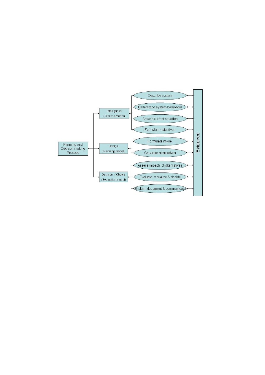
The framework for planning and decision making process involves different phases of
intelligence, design and decision/choice (Sharifi, 2003) is depicted in Figure 1. The
intelligence phase confines to defining, understanding and assessing the existing
situation along with evolving appropriate metrics for quantifying urban sprawl. In the
design phase, the dynamics of urban sprawl are captured and subsequently
modelled. The design phase would conclude with the generation of alternatives. In
the Decision/Choice phase, the review and evaluation of the different policy options
are undertaken to arrive at policy recommendations for managing and mitigating the
urban sprawl.
Figure 1: Planning and decision-making process (Sharifi, 2003)
Most of the existing simulation framework allows simulations only on stand alone
systems, wherein each stakeholder has to choose/decide the options on same
system/platform. This would suggest that all stake holders have to meet physically to
evaluate and decide. Moreover such initiatives are not normal and very difficult to
moderate. In this context, it becomes necessary for a distributed simulation
framework to support SPSS, so that all stake holders and managers/administrators
are able to interact, organise, plan, evaluate and decide through a network. Then the
challenges are two fold: one, to integrate different models that are required to carry
out the simulations and then, to synchronise the model’s inputs, feedbacks and
outputs over space and time.
Currently there are few popular frameworks that try to emulate SPSS with an
objective to make planning interactive and participatory. Among such existing SPSS
are What-If? (Klosterman, 1999), RAMCO (Uljee et al., 1999) etc. What-If?
(Klosterman, 1999) is an interactive GIS-based planning support system that
responds directly to both achieving the ideals of communicative rationality and
traditional comprehensive land use plans. It uses geographic data sets to support
community-based efforts to evaluate the likely implications of alternative public policy
choices. The package can be customised to a community’s existing geographic data,
concerns, and desires, that provides outputs in easy to understand maps and reports
which can be used to support community-based collaborative planning efforts. The
system requires that given a set of factors and factor weights for determining the

Paper 199
10
suitability, projections for future land use and subsequent allocation can be based on
user requirements. Although this system is claimed to be interactive, the dynamics of
the factors and hence their interactions are less captured with only a final land use
scenario obtained as output and doesn’t support a distributed (simulation) framework.
The RAMCO (Rapid Assessment for Management of Coastal zones) is a prototype
information system for regional planning in a generic decision support environment
for the management of coastal zones through the rapid assessment of problems
(Uljee et al., 1999). The system was developed integrating GIS, CA and System
Dynamics. Subsequently, White and Engelen (2000), the developers of RAMCO,
also support the integration of GIS, CA and system dynamics with the usage of
multi-agent systems for a high-resolution integrated modelling of spatial dynamics of
urban and regional systems. This has currently set the standard of technology that
can be used for achieving an integrated spatial planning support system. However,
this also doesn’t yet support a distributed framework.
UrbanSim and OBEUS are two other established frameworks and supporting
packages for integrated modelling of urban systems. UrbanSim is implemented as a
set of packages under Open Platform for Urban Simulation (OPUS) (Waddell et al.,
2005). This is fairly comprehensive in the sense that the framework integrates
land-use, transportation, economic, demographics and environment variables.
However, this framework doesn’t support participatory simulations. The OBEUS
(object-based environment for urban systems) is more robust and is an emerging
trend to integrate various processes as agent-based models to simulate them
spatially and hence is termed as geosimulation (Benenson and Torrens, 2004). The
notion of geographic automata systems (GAS), formalising the fusion of agent-based
and cellular automata models in a spatial framework is demonstrated here. However,
again the key drawback here is that this doesn’t support participatory simulations.
Also, if one may wish to consider each agent-based model as individual
discrete-event simulation model, the OBEUS addresses this using synchronous or
asynchronous updating. It may well be a good frame of reference to build a
distributed simulation framework for enabling participatory decision-making possible.
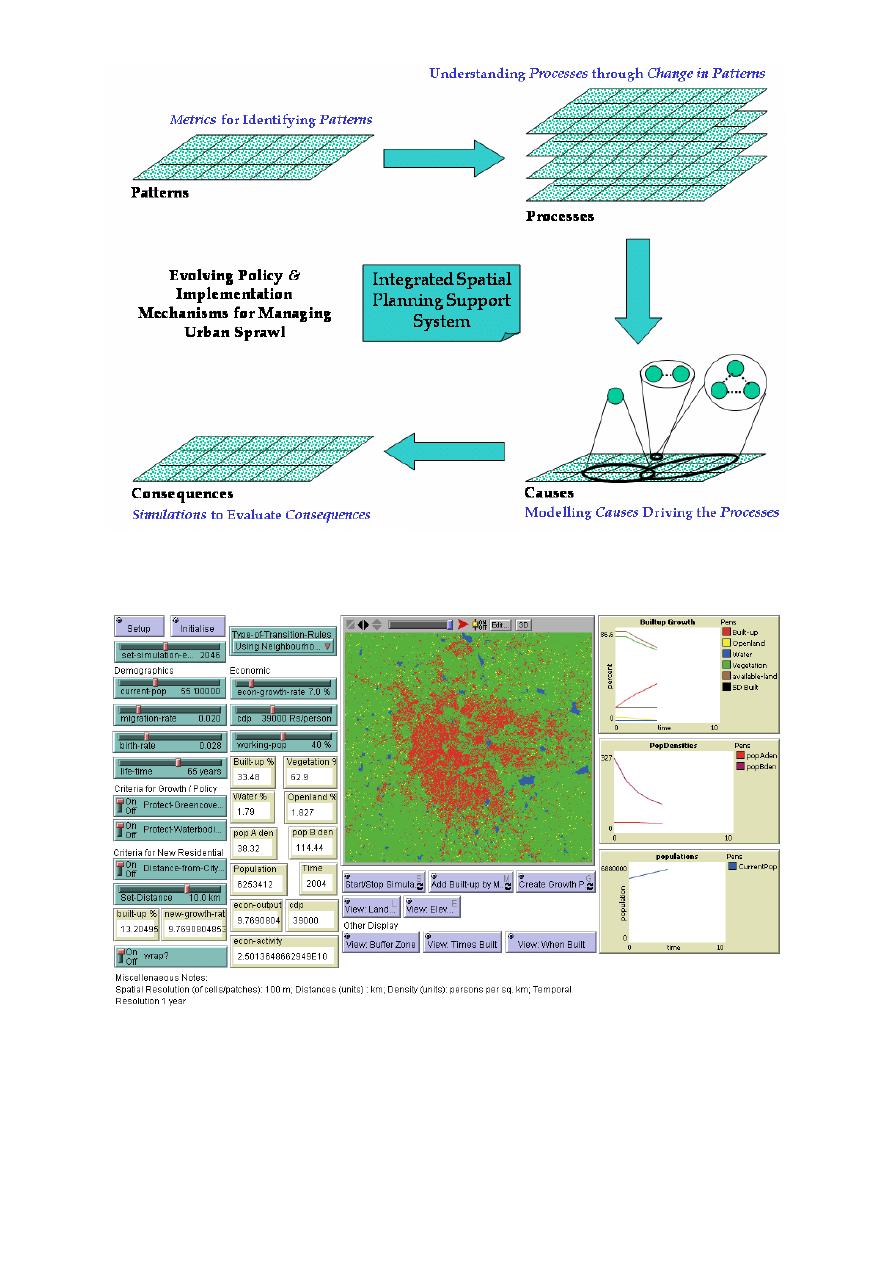
5. PROTOTYPE SPSS THROUGH NETLOGO
Keeping in line with the framework for planning and decision-making process
suggested by Sharifi (2003) a prototype of the SPSS was arrived with the following
four components: Patterns, Processes, Causes and Consequences. Accordingly the
evolution of planning support system is depicted in Figure 2.
Accordingly the model is being implemented using the tool – NetLogo (Wilensky,
1999), an agent-based modelling environment. The agent-based modelling tool
NetLogo developed by the Centre for Connected Learning and Computer Based
Modelling, Northwestern University, USA was used to develop prototype planning
support system since it offers adequate monitors and plots to visualize pattern,
capture processes through agents, model the causes and evaluate the
consequences through simulation. This was tested for Bangalore city. A preliminary
prototype is depicted in Figure 3.
Paper 199
11
Figure 2: Evolution of Planning Support System
Figure 3: Prototype SPSS through NetLogo
The research here in this direction is yet to validate the SPSS. Validation of
agent-based land use models has been a contentious issue in recent times. However,
recent work by Brown et al. (2005) has attempted to clear this debate by
acknowledging path dependence and bringing out the distinction of achieving

Paper 199
12
predictive accuracy and process accuracy. Consequently, it is important that any
SPSS should have greater process accuracy and be able to generate patterns
resulting out of numerous processes. But planners and decision-makers would
always want some amount of predictive accuracy informing them what type/pattern of
growth will emerge at which locations. Thus SPSS should be ideally achieving
reasonable predictive and process accuracies. The process accuracy and predictive
accuracy of this tool is yet to be ascertained. However, the tool in its current state
allows the modeller or experimenter to test for various options and evaluate the
consequences.
6. CONCLUSIONS
Proper implementation of master plans / development plans is a critical aspect in
regulated development of urban areas. Although 1200 master plans / development
plans for important towns and cities have been prepared in India, so far their
implementation has not been satisfactory due to a variety of reasons, which in turn
have resulted in mushrooming of slums and squatters, unauthorised and haphazard
development and above all environmental degradation, lack of basic amenities and
transportation problems within and around urban areas. The city planning mainly
addresses preparation of land use plans through zoning for catering to projected
population. However, civic authorities also need to plan for meeting the demand of
infrastructure facilities and ensuring delivery of basic services. This has been dismal
in the current planning practices since these are normally static master plans or
development plans mostly addressing land use. These plans are also less equipped
to review and evaluate any policy decisions dynamically so as to visualise the
potential implications of a policy directive and also the regions of potential sprawl. It
is therefore necessary to enable the administrators and planners to graduate and
equip with better understanding, methods and tools to tackle the problem of urban
sprawl. Further, administrators and planners need to be informed of possible areas of
sprawl to take corrective actions to mitigate the implications. In this regard, there is a
need for a deeper understanding of urban sprawl phenomenon, capturing the
dynamics and modelling it to visualise, review and evaluate various policy options.
The implications of urban sprawl are not well understood and can potentially be a
threat for achieving sustainable urbanisation. Hence, it is very essential to
understand the phenomenon of urban sprawl especially from the perspective of a
developing country, like India. This would eventually aid in evolving any policy and
management options for effectively addressing the problem of urban sprawl. Further,
the problem of urban sprawl is observed to be an outcome of improper planning,
inadequate policies and lack of good governance due to various reasons. The
inability of the administration and planning machinery to visualise probable areas of
sprawl and its growth is persistent with the lack of appropriate spatial information and
indicators. Added to this, is the inability of administration and planning to capture the
feedbacks arising out of different decisions, essentially with lack of dynamic spatial
models with feedback mechanisms. Furthermore, inappropriate policy decisions are
fuelling sprawl as there is no mechanism to evaluate for different policy implications,
with the lack of spatial planning support systems to test and validate different policy
options.
Thus, in the present context, with the escalating problem of urban sprawl, the
challenges for future research is to arrive at an integrated spatial planning support
system to effectively plan, review and evaluate different policy options while
capturing the dynamics involved. Such an SPSS could also be used to regularly

Paper 199
13
monitor and check the nature of sprawl for compliance of policy recommendations
dynamically over time. The contribution of research by way of spatial planning
support system would only be a short-to-medium term solution to this problem. The
significant driver of sprawl in developing countries is the migration of people from
rural areas aspiring for livelihood to urban areas, which is compounding the problem
of sprawl. Hence, a long term solution can only be achieved through an overall
economic development of the region by the way of better employment and livelihood
generation activities in the rural areas that can lessen the migration of people from
rural areas to urban areas and mitigate urban sprawl.
ACKNOWLEDGEMENTS
We thank Indian Institute of Science for financial and infrastructure support. The
Global Land Cover Facility (GLCF), Institute for Advanced Computer Studies,
University of Maryland, USA, is duly acknowledged for making available the requisite
remote sensing satellite data for the study.
REFERENCES
a) Books and Books chapters
Benenson I. and Torrens P. M. (2004) Geosimulation: Automata-based modeling
of urban phenomena. John-Wiley and Sons, Chichester, UK.
Lowry, I. S. (1967) Seven Models of Urban Development: A Structural Comparison,
in G. C. Hemmens (Ed.) Urban Development Models, Special Report 97, Highway
Research Board, Washington DC, 121-163.
Subudhi, A. P., and Maithani S. (2001) Modeling urban sprawl and future population
prediction using remote sensing and geographical information system techniques. In:
A. P. Subudhi, B. S. Sokhi and P. S. Roy (Eds.), Remote sensing and GIS
application in urban and regional studies. Human Settlement and Analysis Group,
Indian Institute of Remote Sensing, Dehradun, India.
Walter H. (1975) Urban Systems Models. Academic Press, USA.
b) Journal papers
Allen, P.M. and Sanglier, M. (1979) A dynamic model of urban growth: II, Journal of
Social and Biological Systems, Vol. 2, No. 4, 269-278.
Brown, G. D., Page, S., Riolo, R., Zellner, M. and Rand, W. (2005) Path dependence
and the validation of agent-based spatial models of land use. International Journal
of Geographic Information Science, Vol. 19, No. 2, 153-174.
Galster, G., Hanson, R., Ratcliffe, M. R., Wolman, H., Coleman, S., and Freihage, J.,
(2001) Wrestling Sprawl to the Ground: Defining and Measuring an Elusive Concept.
Housing Policy Debate, Vol. 12, No. 4, 681-717.
Geertman, S. and Stillwell, J. (2004) Planning support systems: an inventory of
current practice. Computers, Environment and Urban Systems, Vol. 28, 291–310.
Klosterman, R. E. (1999) The What If? Collaborative Support System. Environment
and Planning B, Vol. 26, 393-408.
Lata, K. M., Sankar Rao, C. H., Krishna Prasad, V., Badrinath, K. V. S., and
Raghavaswamy (2001) Measuring urban sprawl: a case study of Hyderabad. GIS
Development, Vol. 5, No. 12.

Paper 199
14
Pumain, D., Saint-Julien, T. and Sanders, L. (1986) Urban dynamics of some French
cities, European Journal of Operational Research, Vol. 25, No. 1, 3-10.
Sudhira, H.S., Ramachandra, T.V., Raj, K.S. and Jagadish, K.S. (2003) Urban
Growth Analysis using Spatial and Temporal Data, Photonirvachak, Journal of
Indian Society of Remote Sensing Vol. 31, No. 4, 299-311.
Sudhira, H. S., Ramachandra, T.V. and Jagadish, K.S. (2004b) Urban sprawl:
metrics, dynamics and modelling using GIS, International Journal of Applied Earth
Observation and Geoinformation Vol. 5, No. 1, 29-39.
Waddell P. (2002) UrbanSim: Modeling urban development for land use,
transportation and environmental planning, Journal of the American Planning
Association, Vol. 68, No. 3, 297-314.
White, R. and Engelen, G. (2000) High-resolution integrated modelling of the spatial
dynamics of urban and regional system, Computers, Environment and Urban
Systems, Vol. 24, 383-400.
c) Papers presented to conferences
Bates, J.J. and Roberts, M. (1983) Recent experience with models fitted to stated
preference data. Proceedings 11th PTRC Summer Annual Meeting, University of
Sussex, England, 4-7, July 1983.
Jothimani, P. (1997) Operational urban sprawl monitoring using satellite remote
sensing: excerpts from the studies of Ahmedabad, Vadodara and Surat, India, 18th
Asian Conference on Remote Sensing, Malaysia 20–24, October, 1997.
Sharifi M. A. (2003) Integrated Planning and Decision Support Systems for
Sustainable Water Resources Management: Concepts, Potentials and Limitations,
Seminar on Water Resources Management for Sustainable Agricultural
Productivity, organized by Asian Productivity Organization, Lahore, Pakistan.
Sudhira, H. S., Ramachandra, T. V., and Jagadish, K. S. (2004a) Urban Sprawl
dynamics modelling using remote sensing and GIS, 3rd Annual Workshop on
Transportation, Land Use and the Environment: Integrated Urban Transport
Policy, Harvard University Centre for Environment and Administrative Staff College
of India, Hyderabad, India 29–31, January 2004.
d) Other documents
Batty M., Xie Y., and Sun Z. (1999) The dynamics of urban sprawl, Working Paper
Series, Paper 15, Centre for Advanced Spatial Analysis, University College London,
England.
Batty, M. and Torrens, P. (2001) Modelling Complexity: The Limits to Prediction,
Working Paper Series, Paper 36, Centre for Advanced Spatial Analysis, University
College London, England.
Torrens, P.M., and Alberti, M. (2000) Measuring sprawl, Working Paper Series,
Paper 27, Centre for Advanced Spatial Analysis, University College, London.
Uljee I., Engelen G., and White R. (1999) Integral Assessment Module for Coastal
Zone Management, RAMCO 2.0 User Guide, Research Institute of Knowledge
Systems BV, Maastricht, The Netherlands.
United Nations, (2004) Executive Summary, World Urbanisation Prospects: The 2003
Revision, Population Division, Department of Economic and Social Affairs, United
Nations, New York, USA.
Wilensky, U. (1999) NetLogo, http://ccl.northwestern.edu/netlogo Center for
Connected Learning and Computer-Based Modeling, Northwestern University,
Evanston, IL, USA.
Wyszukiwarka
Podobne podstrony:
alcatel support document for cable system in cuba
alcatel support document for cable system in cuba
Miller Recent Developments In Slab A Software Based System For Interactive Spatial Sound Synthesis
INTEGRATED SYSTEM FOR MULTISTOREY BUILDINGS USE OF SOFTWARE ENGINEERING RULES
Bartom NMT support concepts for tunnel in weak rocks
Zied H A A modular IGBT converter system for high frequency induction heating applications
Core Wall Survey Control System for High Rise Buildings
key pro m8 supported models for vw
Popper Two Autonomous Axiom Systems for the Calculus of Probabilities
Microprocessor Control System for PWM IGBT Inverter Feeding Three Phase Induction Motor
Magnetometer Systems for Explosive Ordnance Detection on Land
EASY System for CANopen
The American?ucation System?use for Rebellion
A survey of natural deduction systems for modal logics
Microprocessor Control System for PWM IGBT Inverter Feeding Three Phase Induction Motor(1)
Classification System For Italian Hotels 2007
Audio System for Built In Type Amplifier
więcej podobnych podstron