1587983460
1
drogi, place, ulice roads, squares, streets Wege, Platze, StraBen
budynki murowane kryte dachówką, łupkiem,
blachą cynkową, papą
brick buildings with roofs covered with tiles,
siatę, tinplate, or tar board
gemauerte Gebaude mit Ziegel-, Schiefer-,
Zinkblech- oder Pappdachern
budynki kryte gontem lub deskami buildings with roofs covered with shingles or boards
Gebaude mit Schindel- oder Bretterdachern

budynki własności komunalnej lub państwowej buildings owned by the municipality or State Kommunale oder staatliche Gebaude
zieleń, ogrody i sady
green areas, gardens and orchards
Griinanlagen, Zier- und Obstgarten
Skala liniowa / Linear scalę / LinearmaBstab
50
100
250 m
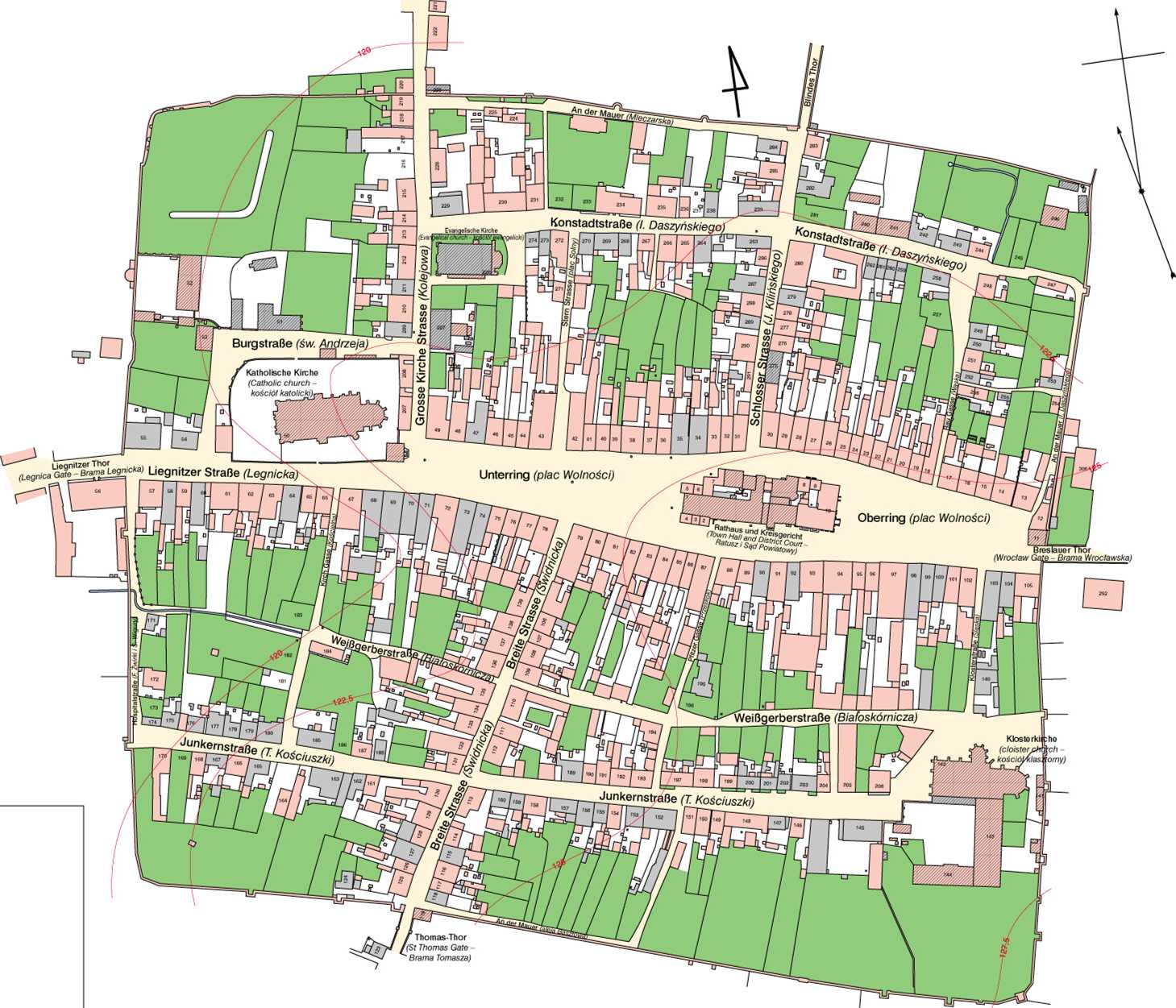
ŚRODA ŚLĄSKA
PLAN KATASTRALNY, 1860
Skalał : 2500
Oprać. R. Eysymontt Oprać. kart. J. Potamarczuk
Plan w skali 1 : 2500 opracowany na podstawie planu sytuacyjnego i mapy pól miasta powiatowego Środa Śląska w skali 1 : 625 (Muzeum Regionalne w Środzie Śląskiej, sygn. MŚR 9).
Współrzędne geograficzne dla bloku śródrynkowego X = 16°35'55 ", <p = 51°09'50”
ŚRODA ŚLĄSKA
CADASTRAL PLAN, 1860
Scalę 1 :2500
By: R. Eysymontt Cartography: J. Potamarczuk
A 1 : 2500 plan based on a site plan and a 1 : 625 map of agri-cultural land of the district town of Środa Śląska (Regional Museum in Środa Śląska, cali number MŚR 9).
Geographical coordinates of the central błock of the Market Square (plac Wolności)
X = 16°35 *55 ”, <p = 51°09'50"
NEUMARKT
KATASTERPLAN
1860
MaBstab 1 :2500
Bearbeitet von R. Eysymontt Kartographische Bearbeitung: J. Potamarczuk
Plan im MaBstab 1 : 2500 bearbeitet auf der Grundlage des Lageplanes und der Flurkarte der Kreisstadt Neumarkt im MaBstab 1 : 625. Regionalmuseum in Neumarkt, Sign.: MŚR9.
Geographische Koordinaten fur den mittleren Ringhauserblock X- 16°35'55", <p = 51°09'50"
ŚRODA ŚLĄSKA. Atlas Historyczny Miast Polskich (IV, 2, 2003)
Wyszukiwarka
Podobne podstrony:
DiU wykłady kozioł literatura Drogi i ulice R.G.Batson WKŁ 1968 historia Drogi kołowe, ulice i w
Ulicówka - typ wsi, zabudowa: dwa szeregi zwartych zagród po obli stronach szerokiej drogi, przypomi
55308 Zdjęcie0592 (3) 215 kalne o nawierzchni Drogi i place lokalne o nawierzchni nt piaszczysty
Slajd1 (102) Politechnika Wrocławska DROGI, ULICE, WĘZŁY I - trasa drogi w planie- drinż. Robert War
Slajd1 (123) Politechnika Wrocławska DROGI, ULICE, WĘZŁY I - uspokojenie ruchu - drinż. Robert Wardę
Roads and Bridges - Drogi i Mosty 14 (2015) 85- 100 85 Roads and Bridges - Drogi i Mosty 14 (2015) 8
95 Roads and Bridges - Drogi i Mosty 14 (2015) 85- 100 wykonanych na tych samych sekcjach nawierzchn
Roads and Bridges - Drogi i Mosty 14 (2015) 85- 100 99 w odróżnieniu od pomiaru głębokości tekstury
Roads and Bridges - Drogi i Mosty 14 (2015) 85- 100 87 Mechanizm powstawania hałasu drogowego jest z
Roads and Bridges - Drogi i Mosty 14 (2015) 85- 100 89 Dysponując obrazem binarnym możliwe było prze
Roads and Bridges - Drogi i Mosty 14 (2015) 85 - 1004. BADANIA TERENOWE Metodę zweryfikowano wstępni
więcej podobnych podstron