1923244571
The excavated pottery clearly indicates that the monument was in use in the Roman
period.
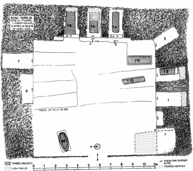
Fig. 7. Petra - Plan of Tomb 64 3. The Monumental Gate: This monumentai
entrance13 to the Qasr el Bint temenos, at the end of the paved Street, was partly restored in 1968 by the Department of Antiąuities, but with-out proper supervision. On the eastem faęade, two of the four free standing columns were re-built and crowned by zoomorphic pseudoionic capitals (PI. CI, 1 & Fig. 8). But it later became obvious that the reconstruction was erroneous; the columns’ shafts were of a smaller size than the original ones, which can be examined in situ in front of the side arches. This failure was rectified in 1979 by dismantelling the two under-
sized columns. It is not elear to what structure the capitals belong.14 According to the bedouins, they were discovered inside the doorway, east of the Gate. The engaged capitals of the western faęade are of the Nabataean type and are 1.05m in diameter*5 as demonstrated by a half Capital still lying at the side of the Street. It is reaso-nable to suppose that the eastern free-standing capitals were of the same type and size. Thus, the argument of Marguerite Lyttleton16 to datę the Gate by the zoomorphic Capital is not con-vicing.
13. Sec W. Bachmann, in Th. Wiegand, Petra, Berlin-Leipzig (1921) p. 49-56; G.H. Wright, 'The arched Gate,
1959-6(5’ PEQ (1961) p. 124ff; ‘Structure et datę de I’arc monumental de Pćtra’ R.B• 73 (1966) p. 404-419.
Wyszukiwarka
Podobne podstrony:
DSC06787 Ryc. 10. Plan rozwoju miejscowości Biedrzychowice (2005) Fig. 10. Plan of development of th
DSC06790 Ryc. 16. Plan rozwoju miejscowości (2004) Fig. 16. Plan of development of the village (2004
DSC06804 Ryc. 32. Plan rozwoju miejscowości Chróścina (2005) Fig. 32 Plan of development of the vill
DSC06805 Ryc. 32. Plan rozwoju miejscowości Chróścina (2005) Fig. 32. Plan of development of the vil
DSC06806 Ryc. 32. Plan rozwoju miejscowości Chróścina (2005) Fig. 32. Plan of development of the vil
DSC06813 Ryc. 38. Plan rozwoju miejscowości Dębie (2005) Fig. 38. Plan of development of the village
DSC06817 Ryc. 44. Plan rozwoju miejscowości Dobieszowice (2007) Fig. 44. Plan of development of the
DSC06914 Ryc. 139. Plan rozwoju miejscowości - waloryzacja zabudowy (2003) Fig 139. Plan of developm
DSC06914 Ryc. 139. Plan rozwoju miejscowości - waloryzacja zabudowy (2003) Fig 139. Plan of developm
DSC06956 Fig. 176. Plan of development of the village (2006) Powiązanie dwóch centralnych miejs
DSC06956 Fig. 176. Plan of development of the village (2006) Powiązanie dwóch centralnych miejs
DSC06990 Ryc. 209. Plan rozwoju miejscowości Rozimierz (2007) Fig. 209. Plan of development of the v
DSC06990 Ryc. 209. Plan rozwoju miejscowości Rozimierz (2007) Fig. 209. Plan of development of the v
DSC07011 Ryc. 228. Plan rozwoju miejscowości (2006) Fig. 228. Plan of development of the village (20
DSC07012 Ryc. 228. Plan rozwoju miejscowości (2006) Fig. 228. Plan of development of the viliage (20
DSC07011 Ryc. 228. Plan rozwoju miejscowości (2006) Fig. 228. Plan of development of the village (20
DSC07013 Ryc. 228. Plan rozwoju miejscowości (2006) Fig. 228. Plan of development of the village (20
DSC07012 Ryc. 228. Plan rozwoju miejscowości (2006) Fig. 228. Plan of development of the viliage (20
DSC07013 Ryc. 228. Plan rozwoju miejscowości (2006) Fig. 228. Plan of development of the village (20
więcej podobnych podstron