
Geol Rundsch (1997) 86 : 585—598
( Springer-Verlag 1997
OR I G I N A L P A P E R
J. A. Tait · V. Bachtadse · W. Franke · H. C. Soffel
Geodynamic evolution of the European Variscan fold belt:
palaeomagnetic and geological constraints
Received: 10 June 1996 / Accepted: 18 December 1996
Abstract The Variscan fold belt of Europe resulted
from the collision of Africa, Baltica, Laurentia and the
intervening microplates in early Paleozoic times. Over
the past few years, many geological, palaeobiogeo-
graphic and palaeomagnetic studies have led to signifi-
cant improvements in our understanding of this oro-
genic belt. Whereas it is now fairly well established that
Avalonia drifted from the northern margin of Gond-
wana in Early Ordovician times and collided with
Baltica in the late Ordovician/early Silurian, the nature
of the Gondwana derived Armorican microplate is
more enigmatic. Geological and new palaeomagnetic
data suggest Armorica comprises an assemblage of
terranes or microblocks. Palaeobiogeographic data in-
dicate that these terranes had similar drift histories, and
the Rheic Ocean separating Avalonia from the Armori-
can Terrane Assemblage closed in late Silurian/early
Devonian times. An early to mid Devonian phase of
extensional tectonics along this suture zone resulted in
formation of the relatively narrow Rhenohercynian
basin which closed progressively between the late De-
vonian and early Carboniferous. In this contribution,
we review the constraints provided by palaeomagnetic
data, compare these with geological and palaeobiogeo-
graphic evidence, and present a sequence of palaeogeo-
graphic reconstructions for these circum-Atlantic
plates and microplates from Ordovician through to
Devonian times.
J. A. Tait (
) · V. Bachtadse · H. C. Soffel
Institut fu¨r Allgemeine und Angewandte Geophysik,
Ludwig-Maximilians Universita¨t, Theresienstrasse 41,
D-80333 Mu¨nchen, Germany
Fax: #49 89 2394 4205
E-mail: jenny@magbakt.geophysik.uni-muenchen.de
W. Franke
Institut fu¨r Geowissenschaften und Lithospha¨renforschung,
Justus-Liebig-Universita¨t, Senckenbergstrasse 3,
D-35390 Giessen, Germany
Key words Variscan fold belt · Armorica ·
Avalonia · Palaeomagnetism · Palaeogeography
Introduction
Palaeomagnetic, faunal and geological evidence all es-
sentially agree that the European sector of the Variscan
fold belt (VFB) is a collage of Gondwana-derived ter-
ranes. These terranes drifted from the northern margin
of Gondwana in early Palaeozoic times, and migrated
northwards to collide with the northern continents. In
recent publications, palaeomagnetists have implied
that these terranes formed two semi-rigid microplates,
Avalonia and Armorica, whereas geological evidence
tends towards more mobilistic models in which Ar-
morica and Avalonia themselves are an amalgamation
of several different terranes. This is mainly due to the
fact that palaeomagnetic data provides information
on the larger-scale latitudinal and rotational motion of
the plates, whereas structural and geological evidence
generally provide smaller-scale details. For example,
the resolution of palaeomagnetic data is such that
separations of the order of up to $500 km cannot be
recognised. Thus, (relatively) small-scale rifting and
intraplate
deformation
(where
no
rotations
are
involved) remain unobserved by the palaeomagnetist,
and the generic term microplate is used in reference to
what the field geologist clearly considers a relatively
loose assemblage of tectonostratigraphic units.
Definition of Armorica and Avalonia
The term ‘‘Armorica’’ was first coined by Van der Voo
(1979) on the basis of palaeomagnetic studies. He
recognised that whereas the early Cambrian segment
of the apparent polar wander (APW) path from the
Armorican Massif coincided with that of Gondwana,
the late Devonian palaeomagnetic data indicated
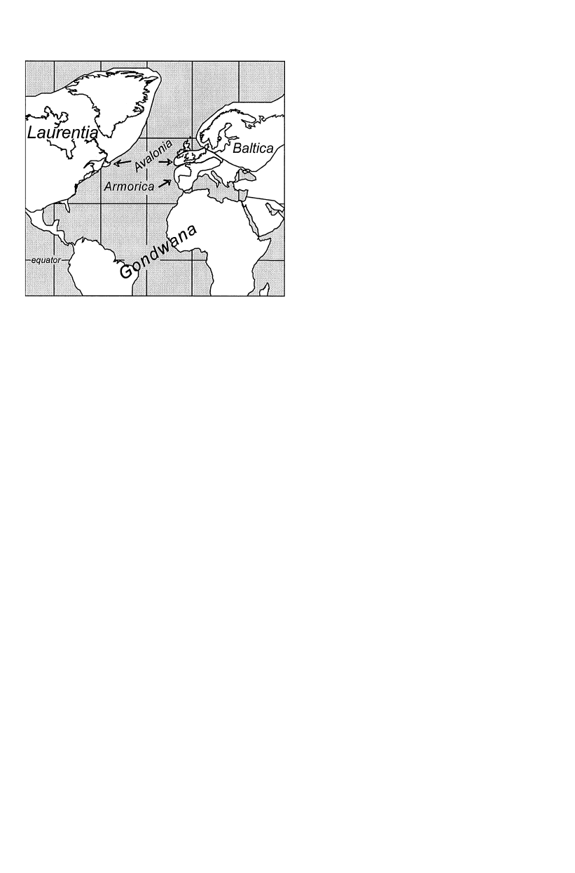
Fig. 1 Map of the present-day orientation and location of the
various lower palaeozoic plates and microplates
separation of the Amorican Massif from Gondwana,
and proximity to northern Europe. Thus, the term
Armorica was adopted to refer to the various terranes
with Cadomian basement now contained within the
Variscan and Alpine fold belts of Europe. However,
major faunal distinctions between some of these Gond-
wana-derived terranes had already been recognised for
a number of years. In the early Palaeozoic reconstruc-
tion of McKerrow and Ziegler (1972), the Avalon and
southern British terranes were placed adjacent to the
northern continents with which they had faunal affin-
ities, whereas southern Europe remained adjacent to
Gondwana. Although there was some evidence in the
palaeomagnetic data set for this configuration (Thomas
and Briden 1976), it remained a matter of controversy
(Perroud et al. 1984). Finally, through detailed
palaeomagnetic studies Trench and Torsvik (1991)
were able to demonstrate that southern Britain drifted
northwards, independent of the Armorican and Iberian
massifs. This microplate was then called Avalonia, and
included coastal New England, New Brunswick, Nova
Scotia and the Avalon Peninsula of Newfoundland all
of which have Cadomian basement and faunal similar-
ities with southern Britain (Fig. 1). Avalonia also ex-
tends eastward into continental Europe to include the
Ardennes and the Rhenohercynian zone of the VFB.
Thus, the remaining parts of Armorica (sensu Van der
Voo 1979) then comprised the Ibero-Armorican block
and the Bohemian Massif (Fig. 1). It remained adjacent
to Gondwana, at least during early Ordovician times,
and was separated from Avalonia by the Rheic Ocean
(sensu McKerrow et al. 1991). The name Armorica has
subsequently been used by palaeomagnetists to refer to
these
three
Variscan
massifs
throughout
early
Palaeozoic times, the implication being that they for-
med a coherent microplate. Whether or not this is valid
has not been fully demonstrated from palaeomagnetic
data, due to the rather sparse data set available for the
European massifs, but faunal similarities indicate that
any separation cannot have been greater than 1500 km
(McKerrow and Cocks 1986). From the geological re-
cord, however, it is clear that Armorica comprised
a number of tectonostratigraphic terranes (Fig. 2), and
thus was a loose assemblage of semi-autonomous ter-
ranes, or even microplates, each of which underwent
similar latitudinal dift histories throughout the early
Palaeozoic. Thus, throughout this paper, the term Ar-
morica is used in a fairly loose sense to refer to the
Armorican Terrane Assemblage (Variscan Europe
south of the Rhenohercynian zone). Discussion of the
validity of this in the light of more recent work will be
given in the final section.
Location of the early Palaeozoic Rheic suture zone
between Avalonia and Armorica has been a matter of
some debate but is thought to be located at the south-
ern margin of the Northern Phyllite zone (NPZ) of
central Europe (Fig. 2). Greenschist metamorphism
characterises this zone which is a tectonic collage con-
taining remnants of both southern Avalonia and north-
ern Armorica, and comprises Ordovician quartzites,
Ordovician/Silurian magmatic arc rocks and mid-up-
per Devonian clastic sequences (Anderle et al. 1995;
Franke and Onken 1995). Geological evidence for the
re-opening of this suture, and formation of the narrow
Rhenohercynian Ocean, in mid to late Devonian times
is found in the association of MORB-type basalts over-
lain by pelagic sediments, and the presence of De-
vonian/Carboniferous subduction-related volcanics in
the mid-German Crystalline High (MGCH) located to
the southeast (Fig. 2). The MGCH represents the
northern margin of Armorica, which, during closure of
both the early Palaeozoic Rheic Ocean, and the later
Rhenohercynian Ocean, represented the northwest
driving active plate margin of northern Armorica. The
MGCH can be traced westwards by boreholes in the
Paris basin and is usually correlated with a ‘‘Norman-
nian High’’ concealed under the British Channel
(Holder and Leveridge 1986). Correlation of tectonic
units further south is difficult: in the French/English
segment of the Variscan fold belt, the Normannian
High is juxtaposed against the Amorican massif. In
central Europe, the MGCH is bounded to the south by
the Saxothuringian basin (Fig. 2). This zone represents
a Cambro-Ordovician rift basin, infilled by neritic clas-
tic sediments and bimodal volcanics, which formed
between the northern driving edge of Armorica and the
Tepla-Barrandian/Moldanubian region to the south.
Whether or not the Saxothuringian basin reached
&&&&&&&&&&&&&&&&&&&&&&&
c
Fig. 2 Map of the early Palaeozoic tectonostratigraphic terranes in
central European segment of the Variscan fold belt
586
587
oceanic status is not clear, but there is evidence for
MORB-type gabbros and ophiolites along the steep
southeastward-dipping shear zone which currently sep-
arates this zone from the Moldanubian and Tepla-
Barrandian. The tectonic units comprising the central
European segment of the Armorican Terrane Assem-
blage thus appear to be more complicated than in the
French and Iberian sectors (see Matte 1991). For cen-
tral Europe, Franke et al. (1995) and Franke and On-
ken (1995) have therefore distinguished N-Armorica
(comprising parts of the MGCH and the continental
foundation of the Saxothuringian basin) from South
Armorica (Tepla-Barrandian), with the narrow inter-
vening Saxothuringian basin being interpreted as a fail-
ed rift. However, as is discussed later, in the light of new
preliminary palaeomagnetic data by Ko¨ssler et al.
(1996) this model can no longer be maintained, and the
Saxothuringian must have formed a separate micro-
plate.
The southernmost part of the Armorican Terrane
Assemblage in central Europe is represented by the
Tepla-Barrandian (Fig. 2), whose stratigraphic and tec-
tonic record are similar to those of the Central Armori-
can zone in France, and the Moldanubian zone. The
latter comprises metamorphic sequences and nappe
units with high pressure and mantle rocks implying the
presence of another major ocean, the Moldanubian
Ocean, to the south. This ocean is thought to be corre-
lated with the French Massif Central Ocean and to
have separated southern Armorica from Gondwana,
and is termed the Massif Central Moldanubian (MCM)
Ocean.
Palaeogeographic reconstructions
Early Ordovician
The palaeogeographic scenario for early Ordovician
times is now fairly well established (Fig. 3). Corre-
spondence and cluster analyses of the various faunal
groups clearly show the three-way nature of the
major continental configurations in which Laurentia,
Gondwana and Baltica formed faunally and geographi-
cally discrete elements. From palaeomagnetic evidence
it is clear that whereas the northern margin of
Gondwana was situated at high, peri-polar latitudes,
Baltica was inverted with respect to its present-
day orientation and was located at intermediate to
high palaeolatitudes (Torsvik et al. 1990; Torsvik
et al. 1992). At the same time, Laurentia, which
was largely covered by warm-water carbonates, was
straddling the equator (McKerrow et al. 1991; Van der
Voo 1993), and essentially remained in this position
with only minor changes throughout the Ordovician
(Cocks and Fortey 1990; MacNiocall and Smethurst
1994).
Fig. 3 Palaeogeographic reconstruction for the early Ordovician
(Tremadoc) using the data of MacNiocall and Smethurst 1994
(Laurentia), Bachtadse and Briden 1991 (Gondwana), Torsvik et al.
1992 (Baltica), Trench et al. 1992 (Avalonia) and Tait et al. 1994a
(Armorica)
Palaeomagnetic studies from the Welsh basin dem-
onstrate that in the Tremadoc this part of Avalonia
was at palaeolatitudes of approximately 60° south
(Fig. 3; McCabe and Channell 1990; Torsvik and
Trench 1991; Trench and Torsvik 1991). Faunal evid-
ence demonstrates, however, that communication be-
tween Avalonia and Gondwana was still possible.
Given that palaeomagnetic data constrains only the
palaeolatitudinal position, this connection can be
achieved if the longitudinal position of Avalonia is
changed such that it is in contact with the northern
margin of South America (Fig. 3). This scenario is also
supported by isotopic analyses of Pre-Cambrian-aged
zircon crystals which indicate that Avalonia may have
originated from the northern margin of South America
(A. Kro¨ner, pers. commun.).
Calc-alkaline volcanism, and the development of
faunas endemic to Avalonia in Llanvirn times, demon-
strates that Avalonia then started to rift from Gond-
wana (Fig. 4) and Armorica, opening up the Rheic
Ocean (sensu McKerrow 1991) in its wake. The onset of
Avalonia’s northward translation and the change from
passive to active margin is marked by the occurrence
of calc-alkaline volcanics of late Tremadocian age
(Cooper et al. 1993; Kokelaar et al. 1984), and sub-
duction-related magmatism continued until late Or-
dovician times (Pharaoh et al. 1993). Palaeomagnetic
data from southern Britain are in agreement with this
scenario and demonstrate a gradual northward drift in
588
Fig. 4 Palaeogeographic reconstruction for the Arenig/Llanvirn us-
ing the data of MacNiocall and Smethurst 1994 (Laurentia), Bach-
tadse and Briden 1991 (Gondwana), Torsvik et al. 1992 (Baltica),
Torsvik et al. 1993 (Avalonia) and Tait et al. 1994a (Armorica)
the Llanvirn, and by the Llandeilo Avalonia was situ-
ated at approximately 45° South (Torsvik et al. 1993;
Trench and Torsvik 1991). Avalonia was separated
from Laurentia to the northwest by the southern
Iapetus Ocean, and from Baltica in the northeast by the
Tornquist Sea.
With regards to Armorica, it is now clear that the
three constituent massifs (Iberian, Armorican and Bo-
hemian) were all situated at high peripolar latitudes
(Fig. 4) in the early Ordovician (Cogne´ 1988; Duff 1979;
Perroud and Bonhommet 1981; Perroud et al. 1986;
Tait et al. 1994a). This is contrary to the model of Krs
et al. (1986, 1987) which, based on palaeomagnetic
evidence, placed the Bohemian Massif at intermediate
palaeolatitudes. It has since been shown, however, that
these data are the result of remagnetisation and incom-
plete separation of palaeomagnetic vectors, as sugges-
ted by Piper (1987) and Van der Voo (1993).
Late Ordovician/Early Silurian
Laurentia, Baltica and Avalonia
The palaeoposition of Laurentia changed only margin-
ally and in the late Ordovician was still straddling the
equator (Fig. 5). Baltica, however, had drifted north-
wards while rotating anti-clockwise and was situated at
more temperate palaeolatitudes (Torsvik et al. 1992).
This is also demonstrated by palaeobiogeographic
Fig. 5 Palaeogeographic reconstruction for the late Ordovician us-
ing the data of MacNiocall and Smethurst 1994 (Laurentia), Bach-
tadse and Briden 1990 (Gondwana), Torsvik et al. 1992 (Baltica),
Trench et al. 1992 (Avalonia) and Tait et al. 1995 (Armorica)
indicators which show a change from the typical
Hirnantia fauna (Kosov province) to the warmer-water
Edgewood faunas at the Ordovician/Silurian boundary
(Owen et al. 1991), and lithological indicators such as
the presence of calcareous oolites in the latest Or-
dovician of the Oslo graben. Development of north-
west-directed subduction along the eastern margin of
Laurentia, and the accretion of the Southern Uplands
trench deposits in the early Caradoc, indicates gradual
closing of the Iapetus Sea between Laurentia and Bal-
tica (McKerrow et al. 1991). Avalonia continued to
drift northwards, above a southerly directed subduc-
tion zone, thus narrowing both the Tornquist and the
southern sector of the Iapetus. By the late Caradoc, the
shallow-shelf faunas of Avalonia were similar to those
of Baltica, and by the Silurian the ostracods were
identical (Berdan 1990). Subduction-related mag-
matism along the leading edge of Avalonia stopped in
the Ashgill, and the presence of Ashgill unconformities
and low-grade metamorphism in Silurian sequences of
Wales, England and Norway are thought to mark the
time of collision (McKerrow et al. 1991; Pharaoh et al.
1993; Roberts 1980; Woodcock 1990). Magmatic activ-
ity is variable along the northern margin of Avalonia.
In the Welsh basin, volcanism was bimodal with minor
calc-alkaline expression, whereas to the east magmatic
activity was primarily calc-alkaline, peaking in early
(mid) Caradoc times in west (east) England, and in
Ashgill times in Belgium (Pharaoh et al. 1993). The
reason for the diachroneity along the Avalonian
589

margin is unclear, but might reflect oblique conver-
gence and/or rotation of the microplate (Oliver et al.
1993; Pharaoh et al. 1993). Thus, from geological and
faunal evidence it is fairly clear that the Tornquist Sea
separating Avalonia and Baltica had closed before the
start of the Silurian, prior to closure of the Iapetus
Ocean between Avalonia and Laurentia.
Palaeomagnetic data provide contrasting models for
the palaeoposition of Avalonia in Siluro-Ordovician
times. Two early studies of the Borrowdale volcanics,
North England, which are stratigraphically con-
strained as latest Llanvirn to early Ashgill in age sug-
gest palaeolatitudes of 15° South (Faller et al. 1977;
Piper 1979), placing Avalonia adjacent to Baltica.
However, the analytical techniques and selection cri-
teria employed in these studies do not stand up to
modern reliability requirements. In a more recent study
of this volcanic complex, Channell and McCabe (1992)
identified a secondary magnetisation direction which
indicates palaeolatitudes of 43° South. This remag-
netisation is thought to be related to late-stage or
syn-volcanic hydrothermal activity and as such is close-
ly bracketed with the rock age, i.e. latest Llanvirn to
early Ashgill. These results are in good agreement with
Siluro-Ordovician data from western Avalonia which,
similarly, indicate palaeolatitudes of approximately 40°
South (Johnson and Van der Voo 1990). However,
assuming relatively constant drift rates, it has been
argued that shallower palaeolatitudes are more likely
(Trench et al. 1992), given that Avalonia drifted from
45° south to 13° South between the Llandeilo and the
Wenlock (Torsvik et al. 1993). Taking into account the
palaeobiogeographic and more recent geological evid-
ence, the reconstruction of Trench et al. (1992) is used in
Fig. 5, placing Avalonia between 30 and 40° South in
the late Ordovician, close to the southern margin of
Baltica.
Armorica and Gondwana
The latest Ordovician is characterised by a period of
global cooling, and the presence of a large ice sheet
centred over North Africa suggests that the northern
margin of Gondwana remained at high palaeolatitudes
throughout the Ordovician (Beuf et al. 1971; Crowley
et al. 1991; Brenchley et al. 1994).
Palaeomagnetic data from Gondwana are ambigu-
ous, and essentially two opposing models for the APW
path have been put forward in order to connect the
well-established cluster of Ordovician palaeomagnetic
poles in northern Africa with the equally well-defined
position of the Carboniferous south pole to the east of
southern Africa. Whereas the first model connects these
two clusters by a direct track, the second model is more
complex involving repeated collision between Gond-
wana and the northern continents, first in early Silurian
and then again in Carboniferous times. This latter
model also involves unlikely drift velocities for Gond-
wana of the order of 25 cm/years. Detailed discussion
of these two alternative models is beyond the scope of
this review, but we adopt the simpler model as the basis
for our palaeogeographic reconstructions (Fig. 5). This
model is in better agreement with the palaeoclimatic
evidence given above, and we refer to Bachtadse and
Briden (1991) and Bachtadse et al. (1995) for detailed
discussion.
The Ordovician glaciation was followed by wide-
spread transgression which caused breakdown of
faunal communities and endemism (Brenchley 1984).
Although analyses of pandemic faunas are of little use
in determining palaeogeographic boundaries, they can
be used as indicators of latitudinal and climatic vari-
ations.
Statistical
analyses
of
early
Palaeozoic
chitinozoans (Achab et al. 1991) demonstrate that in
early Ordovician times essentially three groups —
Laurentia, Baltica and Gondwana (including Armorica
and Avalonia) — can be identified. Although by late
Ordovician the faunas become more heterogeneous,
the basic subdivision between the three groups can still
be made. By the Lower Silurian, however, only two
groups can be clearly identified: the first corresponds to
northern Africa, with the second comprising Laurentia,
Baltica, Avalonia and Armorica.
With regard to the more endemic faunas, although
diversities are much lower in the Ashgill, brachiopod
faunas do show a degree of provincialisation with dis-
tinct latitudinal zonation and climatic variation. Gond-
wana was characterised by the colder water atypical
Hirnantia fauna (Bani Province). Armorica shows
a variation in faunal characteristics, but the variation is
of a spatial rather than temporal nature. The sedimen-
tary record on the Spanish Peninsula is characterised
by the predominance of the cold water Bani province
indicating the increased influence of the African ice
sheet as compared with faunas of the Bohemian massif
which are typical Hirnantia faunas of the Kosov Prov-
ince. This faunal distinction between the Iberian and
Bohemian massifs is not considered to indicate major
separation of these elements for which there is little
geological evidence, but rather a climatic gradient be-
tween these two extremities of the Armorican terrane
assemblage. From facies studies, Young (1990a) sug-
gests that the massifs of Armorica were elongated
north/south. This would allow for a latitudinal range of
approximately 20° between Iberia and the more north-
erly Bohemia.
The presence of Ashgillian glacio-marine sediments
in the Spanish Peninsula, northern France, and the
Bohemian Massif could be taken as evidence for some-
what higher palaeolatitudes. However, these diamic-
tites were deposited from floating or seasonal ice
(Brenchley et al. 1991) and not from the main ice sheet
itself. Recent palaeomagnetic data from the Tepla-
Barrandian of the Bohemian massif (Tait et al. 1995)
show that this part of Armorica was at intermediate
590
palaeolatitudes in the late Ordovician (Fig. 5). This
confirms the idea of Owen et al. (1991) that the effects of
Ashgillian cooling could be felt at intermediate
palaeolatitudes, thus accommodating the deposition
and development of colder-water facies and faunas in
previously warmer water regions.
There are two sets of apparently contradictory re-
sults from coeval sequences in northern France, which
indicate either intermediate (45° south, Crozon Penin-
sula; Perroud et al. 1983) or high (76° south, Thouars
massif; Perroud and Van der Voo 1985) palaeolati-
tudes. Although the rocks studied by Perroud et al.
(1983) are known to be late Ordovician in age, K/Ar
studies of the dolerite sills yield ages ranging from 190
to 300 m.y. This dispersal is thought to be related to
a complex thermal history which, as mentioned by the
original authors, will certainly have had an effect on the
palaeomagnetic record. This, and the lack of any field
tests with which to constrain the age of magnetisation,
renders the results unreliable. Whereas the intrusive
rocks of the Thouars massif yield an Rb/Sr age of
444$9 Ma (Bernard-Griffiths and Le Me´tour 1979),
there is again no structural control for the palaeomag-
netic results, although the original authors argue that
any major tilt (i.e.'20°) of the complex is unlikely.
Thus, from the palaeomagnetic data alone the
palaeoposition of the Amorican Massif is unclear and
the question as
to
whether it
had
a
similar
palaeolatitudinal drift history to Bohemia remains un-
answered. Biostratigraphic and lithological indicators,
however, show no evidence for any major separation
between the Armorican and Bohemian Massifs. The
similarity of Silurian ostracods from these two regions
(Kr
\ ı´z\ and Paris 1982) would make a major oceanic
separation in early Silurian times unlikely unless ex-
tremely high drift rates were involved. Until further
palaeomagnetic data are forthcoming, the palaeolati-
tudes obtained for the Bohemian Massif are considered
representative for the Armorican Terrane Assemblage
and are used for the palaeogeographic reconstruction
given in Fig. 5.
The reconstruction given in Fig. 5 clearly illustrates
that for the late Ordovician Armorica (or at least the
Bohemian Massif) was separated from the northern
margin of Gondwana by an ocean of approximately
3000 km width (the Massif Central Moldanubian
Ocean). At some time between Llanvirn and Caradoc
times, it rifted from Gondwana and started to drift
northwards towards the northern continents. This is in
marked contrast to previously published palaeogeo-
graphic models which have generally assumed that
Armorica remained adjacent to the northern margin of
Gondwana. Evidence for gradual closure of the Rheic
Ocean between Avalonia and Armorica is found in the
presence of upper Ordovician-Silurian calc-alkaline
rocks in the southern Taunus segment of the NPZ
(Sommermann et al. 1990, 1992). These have been inter-
preted as remnants of an island arc, and thus testify to
Fig. 6 Palaeogeographic reconstruction for the Siluro/Devonian
using the data of MacNiocall and Smethurst 1994 (Laurentia), Van
der Voo 1993 (Gondwana), Douglass 1988 (Baltica), Torsvik et al.
1993 (Avalonia) and Tait et al. 1994b (Armorica)
(northward directed?) subduction at the southern mar-
gin of Avalonia and gradual closure of the Rheic Ocean
between Avalonia and Armorica in the Ordovician-
Silurian (see reviews by Anderle et al. 1995; Franke and
Onken 1995; Franke et al. 1995).
Late Silurian/Early Devonian
By latest Silurian times, Baltica had reached an equato-
rial position and was in its present-day orientation
(Fig. 6). Final closure of the northern Iapetus Ocean
between Laurentia and Baltica (Scandian orogeny) was
essentially of a longitudinal nature, and timing of defor-
mation during the Siluro-Devonian relies principally
on biostratigraphic control and isotopic dating. Defor-
mation related to the Scandian orogeny was polyphase
in Scandinavia and concentrated in the time range late
Llandovery to early Devonian (Roberts 1988). The first
appearance of Laurentian-derived sediments occurred
in southern Norway and Sweden in the late Llandovery
(Bassett 1985), and the main period of nappe emplace-
ment and deformation along the eastern margin of the
orogen has been dated as mid Silurian. In Scotland,
calc-alkaline volcanism related to subduction on the
northwest margin of the Iapetus Ocean continued into
the Lower Devonian (Smith 1995; Thirlwall 1988), sub-
duction ceased in early Devonian times and collision is
marked by late Silurian deformation. In the Ap-
palachians, subduction below Laurentia continued into
591

the Devonian as Avalonia swung in towards the
Laurentian margin (McKerrow et al. 1991).
In central Europe, the Rheic Ocean separating Ava-
lonia from Armorica was also closing, only to be
opened again in early-mid Devonian times with devel-
opment of the Rhenohercynian basin (Franke and On-
ken 1995). Palaeomagnetic data indicates that by the
late Silurian Bohemia had reached fairly shallow
palaeolatitudes (ca. 30° south; Fig. 6), and was thus
adjacent to the southern margin of Baltica/Avalonia
(Tait et al. 1994b; Channell et al. 1992). Two other
Siluro-Devonian palaeopoles are available for Ar-
morica, from the San Pedro redbeds in Asturia, Spain
(Perroud and Bonhommet 1984), and from Almaden in
southern Spain (Perroud et al. 1991). Whereas it has
subsequently been demonstrated that the Almaden
rocks have been remagnetised, the San Pedro results
indicate palaeolatitudes of approximately 20° south for
Iberia. Within the error limits, this is in fairly good
agreement with the Bohemian data. However, as
pointed out by the original authors the age of magnet-
isation in the San Pedro sediments is fairly loosely
constrained and could have been acquired anywhere
between the Siluro-Devonian and early Carboniferous.
Nevertheless, the results indicate that the ocean sep-
arating Armorica from the northern continents had
closed, or had at least been reduced below the
palaeomagnetic detection limit, by this time (Fig. 6).
This scenario is in good agreement with palaeobiogeo-
graphic indicators which show a complete interchange
of Armorican and Baltic faunas by the late Silurian,
and the first warm-water carbonates appeared in the
Tepla-Barrandian in late Silurian/early Devonian
times, and in the Iberian and Amorican Massifs in the
early Devonian. An important feature to be recognised
is that all recently published palaeomagnetic data from
the early Palaeozoic of Bohemia place the Tepla-Bar-
randian in an inverted position with respect to its
present-day orientation, indicating a post-Silurian anti-
clockwise rotation of up to 140°. Although, as discussed
previously, reliable palaeomagnetic data from the Ar-
morican and Iberian Massifs are lacking, it is con-
sidered unlikey that the rotation relates to the Armori-
can assemblage as a whole. Recent palaeomagnetic
results
from
Silurian
carbonate
rocks
of
the
Saxothuringian basin (Ko¨ssler et al. 1996) confirm this
and demonstrate that this region did not take part in
the post-Silurian rotation, thus restricting it to a more
local level involving the Tepla-Barrandian.
Palaeomagnetically this rotation is constrained to
have occurred sometime between the early Devonian
and late Carboniferous, and stricter constraints are
available from the geological record. Zircon, horn-
blende and mica ages from metamorphic rocks relating
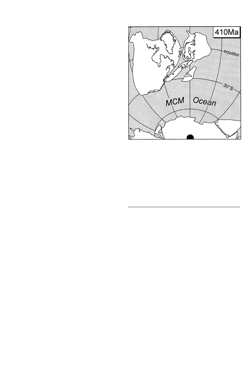
to the suture zone cluster around 380—370 Ma, which
indicates rapid uplift and cooling, probably due to
collision of the Tepla-Barrandian and the Saxothurin-
gian (i.e. between northern and southern Armorica;
Franke et al. 1995). Collision is also constrained by
early Famennian flysch greywackes encountered in the
southernmost part of the Saxothuringian basin, which
were deposited on Saxothuringian continental base-
ment. This indicates that any oceanic separation be-
tween the Tepla-Barrandian source area and the
Saxothuringian foreland had disappeared by that time
(Franke and Engel 1986). The Famennian flysch con-
tains detrital zircon dated at 380 Ma (Scha¨fer and Do¨rr
1994; Do¨rr et al. 1989). This leaves no doubt that the
continental crust of the Tepla-Barrandian and the
Saxothuringian had made contact before the Famen-
nian, probably in the late middle Devonian (ca. 380 Ma).
As discussed above, the position of Gondwana in
Silurian times remains controversial. Adopting the
more complex APW path implies closure of a wide
ocean between Baltica/Laurentia and Gondwana by
the early Silurian, with subsequent re-opening of this
ocean during the late Silurian/early Devonian. From
the late Devonian onward, this ocean then closed again
and the classic Pangea assemblage was established in
the Carboniferous. However, the more conservative,
and preferred, APW path places the northern margin of
Gondwana at more intermediate palaeolatitudes, with
the presence of a late Silurian ocean of approximately
2500 km width between Gondwana and the northern
continents
(Massif
Central—Moldanubian
Ocean).
There is evidence for Silurian oceanic crust in the
southeastern part of the Moldanubian (Finger and
Quadt 1995), and in the Sudetes (circum Sowie-Gory
ophiolite; Oliver et al. 1993) which is compatible with
the more conservative APW path. Furthermore, evid-
ence for a Silurian age collisional event has never been
detected anywhere to the south of the Tepla-Barran-
dian. All petrological and isotopic evidence available
suggest
that
the
allochthonous
Moldanubian
granulites and associated high-grade rocks were for-
med around 340 Ma (Medaris et al. 1995).
Late Devonian/Carboniferous
Whereas the major oceans separating the various
plates now comprising Europe had closed by the De-
vonian, final consolidation into the present-day config-
uration of Variscan Europe did not occur until some
time later. From geological evidence it is clear that this
period was a time of large-scale shearing, transpres-
sional movement with the opening of small oceanic
basins (Franke 1989; Matte 1991; Quesada 1991).
Palaeomagnetic data further demonstrate that there
was large-scale differential rotation and deformation
throughout the belt (Hirt et al. 1992; Ries and Shack-
leton 1976; Tait et al. 1994b).
Palaeomagnetic data for the Devonian of Baltica
are sparse. Early Devonian poles from the Ukraine
and Spitsbergen (Smethurst and Khramov 1992)
592
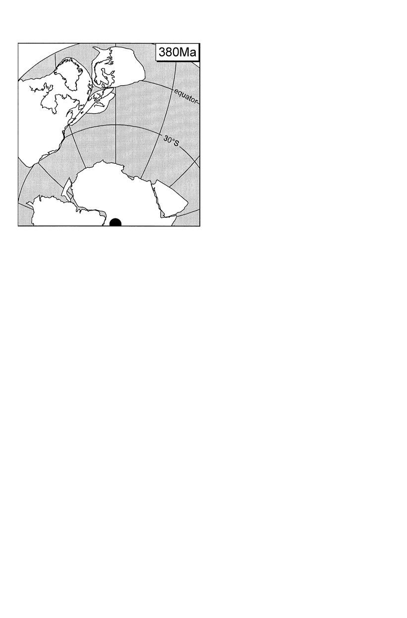
Fig. 7 Palaeogeographic reconstruction for Devonian using the
data of MacNiocall and Smethurst 1994 (Laurentia), Van der Voo
1993 (Gondwana), Torsvik et al. 1992 (Baltica), Trench et al. 1992
(Avalonia) and Bachtadse et al. 1983 (Armorica)
demonstrate an equatorial position for Baltica, but for
mid and late Devonian times there are very few reliable
palaeomagnetic poles for Baltica as most results have
been shown to comprise overprints (Torsvik et al.
1990). Nevertheless, it is clear that by this time the
oceans separating Baltica from Laurentia, Avalonia
and Armorica had all closed (McKerrow et al. 1991;
Torsvik et al. 1990; Torsvik et al. 1993; Van der Voo
1993) thus forming the Old Red Continent (Fig. 7).
The palaeomagnetic data set for Armorica and Ava-
lonia during the late Devonian is rather sparse. Per-
roud et al. (1985) have shown that the data of Jones
et al. (1979) from Normandy fail the fold test, and only
two pole positions from the Central European Harz
Mountains and the Franconian Forest (Bachtadse et al.
1983) are believed to represent primary magnetisations.
The resulting palaeolatitudes of 13° south indicate the
proximity of Armorica to Baltica (Fig. 7) and the clos-
ure of any intervening ocean.
An interesting feature of the European Variscides is
that during this period of overall convergence and
compression, there was a phase of extensional tectonics
and basin development in the Rhenohercynian zone
(Behr et al. 1984; Engel et al. 1983; Floyd 1995). In
Germany, lower-Devonian acid volcanics are followed
by mid-Devonian intra-plate continental tholeiites,
whereas in southwest England basic and acid volcanics
occur throughout the Devonian. These suites in south-
west England have been interpreted as a rifted passive
continental margin which became truly oceanic to-
wards the south (Floyd 1984; Thirlwall 1988). This
basin probably extended eastwards into the Rhenoher-
cynian zone of Germany, where thick accumulations of
Devonian shelf and haemipelagic sediments associated
with bimodal volcanism, MORB-type mafic rocks,
clearly suggest extension and opening of the Rhenoher-
cynian basin along the suture zone of the former Rheic
Ocean. This oceanic basin must have remained fairly
limited, however, as it cannot be recognised in the
palaeomagnetic record. The onset of convergence is
documented by the late Devonian (Frasnian/Famen-
nian) flysch and greywacke deposition, and foreland
basin-type
sedimentation
throughout
the
entire
Rhenohercynian belt, from Portugal to Moravia
(Franke and Engel 1986).
One of the most pronounced features of the Euro-
pean Variscan fold belt is that of the Ibero-Armorican
arc. Ries and Shackleton (1976) concluded from strain
analyses that this arc is similar to a buckle fold with
tangential longitudinal strain, and hence is secondary
in nature. Previously, however, Julivert (1971) and Jul-
ivert and Marcos (1973) had demonstrated that the arc
was to some extent primary in nature, but had under-
gone secondary tightening and development of radial
folds during the Variscan orogeny (late Carboniferous).
This model was subsequently supported by Julivert and
Arboleya (1984, 1986) and Pe´rez-Estau´n (1988) from
studies of kinematic indicators and thrust sheet em-
placement mechanisms. The third model considers cur-
vature of the arc as resulting from indentation of a rigid
block, either as a separate microplate (Lorenz 1976;
Lorenz and Nicholls 1984; Riding 1974) or collision of
irregularly shaped continents, i.e. indentation of an
African promontory (Julivert and Martinez 1987,
Matte and Ribeiro 1975). Several palaeomagnetic stud-
ies have been carried out in the Asturian arc, and in
most the declination deviation follows the shape of the
arc, indicating the secondary nature of the orocline
(Bonhommet et al. 1981; Hirt et al. 1992; Lowrie and
Hirt 1986; Perroud 1983; Ries et al. 1980; Ries and
Shackleton 1976).
Plotting the European Carboniferous and Devonian
declination data on the map, a systematic pattern of
declination deviation becomes apparent, which is most
pronounced around the Bay of Biscay, the Ibero-Ar-
morican arc. These deviations have been identified as
being a direct function of the change in general strike
along the northern margin of the Variscan mountain
belt as discussed by Bachtadse and Van der Voo (1986)
and Perroud (1986) and Bachtadse (1990). One possible
interpretation of this declination pattern is that it re-
flects large-scale thrust rotations (especially around the
Ibero-Armorican arc, the Rhenish massif and the Ar-
dennes) and/or pervasive strike-slip tectonics in the
more internal parts of the orogen (Harz Mountains,
Franconian Forest, Massif Central). Indentation of the
irregularly shaped northern margin of Gondwana into
Europe during the final stages of suturing between
593

Gondwana the northern continents is one possible ex-
planation for this deformation pattern (Bachtadse and
Van der Voo 1986). This interpretation is supported in
the geological record, by the presence of the South-
Armorican and Badajoz-Cordoba shear zones, whose
respective dextral and sinistral displacements fit the
general model (see also Matte 1986).
Combining all the palaeomagnetic data available for
the Ibero-Armorican arc demonstrates that there is
a strong correlation between change in strike and decli-
nation (Bachtadse and Van der Voo 1986; Eldredge
et al. 1985; Tait et al. 1996). However, it is not a 1 : 1
correlation as would be expected for perfect oroclinal
bending, indicating that the arc had a primary curva-
ture, as originally proposed by Julivert (1971), prior to
tightening during the latter stages of the Variscan oro-
geny. Furthermore, in the most recent palaeomagnetic
study by Hirt et al.(1992), the authors demonstrate that
the vertical axis rotations observed in the thrust sheets
are most compatible with the indentation model. Such
a model was first proposed by Riding (1974) who sug-
gested that northern Spain, comprising the Cantabrian,
Pyrenean and Montagne Noire regions, formed either
an extension of Africa or a separate microplate prior to
Westphalian collision. This model has subsequently
gained support from the geological record (Feist and
Echtler 1990; Julivert and Martinez 1987), but data are
still sparse due to the tectonically complex nature of
these regions.
Oroclinal bending is also a major feature in the
eastern extremity of the Variscan fold belt as demon-
strated by Tait et al. (1996). Geological similarities
between the Moravo-Silesian zone to the southeast of
the Bohemian massif and the Rhenohercynian of cen-
tral Europe have long been recognised, but it was
unclear whether the present configuration was a pri-
mary or secondary feature (Burchette 1981; Franke
1989). However, the new palaeomagnetic data demon-
strate a close correlation between declination and
strike deviation and hence the secondary nature of the
arc. The mechanism involved to produce the curvature
of the Rhenohercynian zone around the northeastern
flanks of the Bohemian massif may again be one of
indentor tectonics. Geological evidence for this, how-
ever, is not so clear. Whereas the dextral transpressive
Moldanubian thrust flanks the southeastern margin of
the Bohemian massif, there is little evidence for sinistral
shear along the northwest flank. All the major shear
zones to the north of the Moldanubian s.st.(southern
and northern margin of the Tepla-Barrandian, north-
ern margin of the MGCH) have dextral displacements.
Tectonic rotation of the Moravo-Silesian zone, there-
fore, remains problematic.
The position of Gondwana in the Devonian is again
controversial, with major apparent discrepancies
between the palaeomagnetic and palaeoclimatological
indicators. The central African location of the late
Devonian palaeo-south pole which was based on the
results of Hailwood (1974) has been questioned repeat-
edly, mainly on the basis of palaeoclimatological
(Scotese and Barrett 1990; Wendt 1985) and radiomet-
ric evidence (Salmon et al. 1986). However, more re-
cently high-quality palaeomagnetic data for the late
Devonian of cratonic Australia (Hurley and Van der
Voo 1987), northern (Bachtadse and Briden 1991) and
southern Africa (Bachtadse et al. 1987) are in strong
support of the central African pole position. When the
palaeolatitudes for the northern coast of Africa, based
on this pole, are compared with the palaeolatitudes for
the southern margin of the Old Red Continent (Fig. 7),
an ocean of up to 4500-km width is indicated for mid-
Devonian times. Palaeomagnetic evidence shows that
by the late Devonian this ocean had closed somewhat,
and collision is considered to have been initiated in the
early Carboniferous. The evidence for this ocean from
palaeobiogeographic data is ambiguous. Evidence
against the presence of an ocean is to be found in the
Emsian rugose corals of North Africa which bear
strong similarities to those of Armorica and Avalonia,
suggesting that there was no major barrier between
these regions (Pedder and Oliver 1990). The presence of
reef carbonates in North Africa may also be taken as
evidence that the northern margin of Gondwana was at
fairly shallow palaeolatitudes ((45° south). On the
other hand, climates in the mid to late Devonian were
exceptionally warm and reef habitats widespread (Cop-
per 1986). Positive support for the ocean comes from
analysis of Devonian vertebrate faunas (Young 1990b).
In early to mid Devonian times, Gondwana had a ver-
tebrate fauna distinct from that of Eurasia and Amer-
ica, but by the late Devonian there was faunal
communication between these areas. It has also been
suggested that closing of the ocean between the Old
Red Continent and Africa in the late Devonian was one
of the main causes for the late Devonian (Frasnian/
Fammenian) faunal crisis (Copper 1986). Many geol-
ogists, however, argue further that the Silurian to Car-
boniferous metamorphism, and general south- or
southeast-directed tectonic transport in the Massif
Central and South Armorican domain, are indicative of
a prolonged subduction/collision story between Ar-
morica and a southern opponent — Gondwana. Thus,
the problem with regard to the relationship between
Gondwana and the northern continents remains
enigmatic and a matter of debate between many
palaeomagnetists and geologists.
Summary
Avalonia and the Armorican Terrane Assemblage are
characterised by Cadomian basement, derived from the
northern margin of Gondwana — either North Africa
(Armorica) or, possibly, South America (Avalonia),
as indicated by zircon ages. Palaeomagnetic data, the
onset of calc-alkaline magmatism in Avalonia in the
594

Tremadoc and development of endemic faunas all indi-
cate that Avalonia rifted from Gondwana in the early
Ordovician and started to move northwards, with sub-
duction of the intervening Tornquist Sea along a south-
ward-dipping subduction zone. Palaeomagnetic data
for Armorica (Bohemian Massif) indicates by the late
Ordovician Armorica had also drifted northwards, and
away from Gondwana. The timing of rifting, however,
is not clear. The oldest known calc-alkaline rocks re-
lated to closure of the Rheic between Avalonia and
Armorica are Upper Ordovician in age. By early Silur-
ian times, Avalonia had collided with Baltica, and the
Iapetus Ocean between Laurentia and Baltica had nar-
rowed considerably. Closure of this longitudinal ocean
was diachronous. Deformation in Scandinavia peaked
in mid-Silurian times (Roberts 1988), in Scotland colli-
sion is marked by Upper Silurian deformation, and
calc-alkaline volcanism continued into the Lower
Devonian (Smith 1995; Thirlwall 1988). In the Ap-
palachians, subduction below Laurentia continued into
the Devonian as Avalonia moved in towards the
Laurentian margin (McKerrow et al. 1991).
The Armorican Terrane Assemblage continued to
drift northwards during the Silurian, with closure of the
Rheic Ocean between Avalonia and Armorica in late
Silurian times. This suture was to reopen in the early
Devonian with formation of a relatively narrow rift
generated Rhenohercynian basin that was sufficiently
attenuated in its internal zone to produce oceanic crust
with MORB-type basalts. During this time, the Tepla-
Barrandian rotated some 140° anticlockwise prior to
consolidation with the Saxothuringian in the late De-
vonian, and the Rhenohercynian basin progressively
closed between late Devonian and early Carboniferous
times.
Since the Tepla-Barrandian shows post-Silurian/pre-
380-Ma rotation, and the Saxothuringian does not, it is
no longer possible to maintain the proposal of Franke
et al. (1995, and earlier references) that the Saxothurin-
gian Ocean was a westward-closing failed rift between
‘‘North Armorica’’ (Saxothuringian continental crust
and including parts of the MGCH) and ‘‘South Ar-
morica’’ (Tepla-Barrandian). The Saxothuringian con-
tinental crust must have been a separate microplate
(see also Vollbrecht et al. 1988), but with a drift history
similar to that of the Tepla-Barrandian as evidenced by
the similar faunal and facies developments throughout
the early Palaeozoic. Another curious feature of the
Saxothuringian is that in palinspastic restorations,
such as that given by Franke et al. (1995), the
Saxothuringian Ocean is to the south, with the
Saxothuringian autochthon and its shelf facies situated
to the north. However, as the MGCH is too narrow to
qualify for the source of all the Cambro-Ordovician
clastics in the autochthon, the continental source area
which would be expected to the north remains enig-
matic and the shelf facies of Saxothuringia is adjacent
to the Rheic Ocean.
The other main unanswered questions regard the
drift history of Gondwana, and whether or not there
was an ocean separating Gondwana from the northern
continents in mid-late Devonian times. Additional
problems not addressed in this paper regard the south-
ern flanks of the Variscan fold belt. Several lower
Palaeozoic sequences crop out along the southern mar-
gin of Europe, e.g. the central Pyrenees, Montagne
Noire, Greywacke zone, Carnic Alps and the Karawan-
ken. However, these sequences suffered varying degrees
of deformation during the Alpine orogeny, making
determination of their tectonic affinities from structural
and stratigraphic analysis alone complicated. Although
palaeomagnetic studies of these sequences are also
problematic, preliminary results from the greywacke
zone of the eastern Alps have yielded encouraging
results (Scha¨tz et al. 1996), and it is hoped that con-
tinued research of these massifs over the coming years
will provide further insight and constraints on the plate
tectonic affinities of these regions.
Acknowledgements This project was supported by the German Re-
search Council (DFG), project numbers So72/52—3 and Ta193/1—2,
and is a contribution towards the Special Research Project ‘‘Oro-
genic Processes’’ funded by the DFG. Many thanks also to Profes-
sors Weber and Torsvik for their helpful comments on the manu-
script.
References
Achab A, Betrand R, Van Grootel G (1991) Chitinozoan contribu-
tion to the Ordovician and Lower Silurian paleobiogeography.
J Geol 100 : 621—629
Anderle H-J, Franke W, Schwab M (1995) III.C.1 Stratigraphy. In:
Dallmeyer RD, Franke W, Weber K (eds) Pre-Permian geology
of central and eastern Europe. Springer, Berlin Heidelberg New
York, pp 99—107
Bachtadse V (1990) Hercynian palaeomagnetism of Europe: argu-
ments for large-scale complex thin-skinned and thick-skinned
rotations. Cuadernos Geol Iberica 12 : 147—162
Bachtadse V, Van der Voo R (1986) Paleomagnetic evidence for
crustal and thin-skinned rotations in the European Hercynides.
Geophys Res Lett 13 : 161—164
Bachtadse V, Briden JC (1990) Paleomagnetic constraints on the
position of Gondwana during Ordovician to Devonian times. In:
McKerrow WS, Scotese CR (eds) Palaeozoic biogeography and
palaeobiogeography. Mem Geol Soc Lond 12 : 43—48
Bachtadse V, Briden JC (1991) Palaeomagnetism of Devonian ring
complexes from the Bayuda Desert, Sudan: new constraints on
the apparent polar wander path for Gondwanaland. Geophys
J Int 104 : 635—646
Bachtadse V, Heller F, Kro¨ner A (1983) Paleomagnetic investiga-
tions in the Hercynian mountain belt of central and western
Europe. Tectonophysics 91 : 285—299
Bachtadse V, Van der Voo R, Halbich IW (1987) Paleozoic
paleomagnetism of the western Cape fold belt, South Africa.
Earth Planet Sci Lett 84 : 487—499
Bachtadse V, Torsvik TH, Tait JA, Soffel HC (1995) X Paleo-
magnetic
constraints
on
the
paleogeographic
evolution
of
Europe
during
the
Paleozoic.
In:
Dallmeyer
RD,
Franke W, Weber K (eds) Pre-Permian geology of central
and eastern Europe. Springer, Berlin Heidelberg New York,
pp 567—578
595

Bassett MG (1985) Silurian stratigraphy and facies development
in Scandinavia. In: Gee DG, Sturt BA (eds) The Caledonian
orogen: Scandinavia and related areas. Wiley, Chichester,
pp 283—292
Bernard-Griffiths J, Le Me´tour J (1979) Age (limite Ordovicien-
Silurien) de mise-en-place du massif hypovolcanique de Thouars
(Massif Vende´en): Imu¨lications ge´ologiques. Bulletin du Bureau
du Reche´rches Ge´ologique et Mineralogique 2e Se´rie, sect. 1, 4,
pp 365—371
Berdan JM (1990) The Silurian and Early Devonian biogeography
of ostracodes in North America. In: McKerrow WS, Scotese CR
(eds) Palaeozoic biogeography and palaeobiogeography. Mem
Geol Soc Lond 12 : 223—231
Behr H-J, Engel W, Franke W, Giese P, Weber K (1984) The
Variscan belt in Central Europe: main structures, geodynamic
implications, open questions. Tectonophysics 109 : 15—40
Beuf S, Biju-Duval B, Charpal O de, Rognon P, Gariel O, Bennacef
A (1971) Les gre`s du Pale´ozoique infe`rieur au Sahara. Se´dimenta-
tion et discontinuite´. Evolution structurale d’un craton. Edition
Technip, Paris
Bonhommet N, Cobbold NR, Perroud H, Richardson A (1981)
Palaeomagnetism and cross-folding in a key area of the Asturian
arc (Spain). J Geophys Res 86 : 1873—1887
Brenchley PJ (1984) Late Ordovician extinctions and their relation-
ship to the Gondwana glaciation. In: Brenchley PJ (eds) Fossils
and climate. Wiley, Chichester, pp 291—327
Brenchley PJ, Romano M, Young TP, Storch P (1991) Hirnantian
glaciomarine diamictites: evidence for the spread of glaciation
and its effect on Upper Ordovician faunas. In: Barnes CR (eds)
Advances in Ordovician geology. Geol
Surv Can Pap
90—9 : 325—336
Brenchley PJ, Marshall JD, Carden GAF, Robertson DBR, Long
DGF, Meidla T, Hints L, Anderson TF (1994) Bathymetric and
isotopic evidence for a short lived Late Ordovician glaciation in
a greenhouse period. Geology 22 : 295—298
Burchette TP (1981) European Devonian reefs: a review of current
concepts and models. SEPM Spec Publ 30 : 85—142
Channell JET, McCabe C (1992) Paleomagnetic data from the
Borrowdale volcanic group (English Lake District): volcano-tec-
tonics and Late Ordovician paleolatitudes. J Geol Soc Lond
149 : 881—888
Channell JET, McCabe C, Woodcock (1992) Early Devonian (pre-
Acadian) magnetization directions in Lower Old Red Sandstone
of south Wales (UK). Geophysical J Int 108 : 883—894
Cocks LRM, Fortey RA (1990) Biogeography of Ordovician and
Silurian faunas. 12, pp 97—104
Cogne´ J-P (1988) Strain, magnetic fabric, and palaeomagnetism of
the deformed red beds of the Pont-Rean formation, Brittany,
France. J Geophys Res 93 : 13673—13687
Copper P (1986) Frasnian/Famennian mass extinction and cold
water oceans. Geology 14 : 835—839
Cooper AH, Millward D, Johnson EW, Soper NJ (1993) The early
palaeozoic
evolution
of
northwest
England.
Geol
Mag
130 : 711—724
Crowley TJ, Baum SK, Hyde WT (1991) Climate model comparison
of Gondwanan and Laurentide glaciations. J Geophys Res
96 : 9217—9226
Douglass DN (1988) Palaeomagnetics of Ringerike Old Red Sand-
stone and related rocks, southern Norway: implications for pre-
Carboniferous separation of Baltica and British terranes. Tec-
tonophysics 148 : 11—27
Do¨rr W, Franke W, Kramm U (1989) U/Pb-Daten von Zirkonen
klastischer Sedimente — Beitra¨ge zur Entwicklung der Bo¨hmis-
chen Masse. KTB Rep 89—3 : 351
Duff BA (1979) The palaeomagnetism of Cambro-Ordovician red-
beds, the Erquy Spilite series, and the Tre´gastel-Ploumanac’h
granite complex, Armorican massif (France and the Channel
Islands). Geophys J R Astron Soc 59 : 345—365
Eldredge S, Bachtadse V, Van der Voo R (1985) Paleomagnetism
and the oroclinal hypothesis. Tectonophysics 119 : 153—179
Engel W, Franke W, Grote C, Weber K, Ahrendt H, Eder FW
(1983) Nappe tectonics in the southeastern part of the
Rhenisches Schiefergebirge. In: Martin H, Eder FW (eds) In-
tracontinental foldbelts. Springer, Berlin Heidelberg New York,
pp 267—287
Faller AM, Briden JC, Morris WA (1977) Palaeomagnetic results
from the Borrowdale volcanic group, English Lake District.
Geophys J R Astron Soc 48 : 111—121
Feist R, Echtler H (1990) Biostratigraphy and sedimentary dynamics
of southern Massif Central. In: Keppie D (eds) Pre-Mesozoic
terranes in France and related areas. Springer, Berlin Heidelberg
New York
Finger F, Quadt A (1995) U—Pb ages of zircons from a plagiog-
ranite-gneiss in the southeastern Bohemian massif, Austria: fur-
ther evidence for an important early Palaeozoic rifting episode
in the eastern Variscides. Schweiz Mineral Petrogr Mitt
75 : 265—270
Floyd PA (1984) Geochemical characteristics and comparison of the
basic rocks of the Lizard complex and the basaltic lavas within
the Hercynian throughs of SW England. J Geol Soc Lond
141 : 61—70
Floyd PA (1995) III.B.3 Igneous activity. In: Dallmeyer RD, Franke
W, Weber K (eds) Pre-Permian geology of central and eastern
Europe. Springer, Berlin Heidelberg New York, pp 59—81
Franke W (1989) Tectonostratigraphic units in the Variscan belt
of central Europe. In: Dallmeyer RD (eds) Terranes in the cir-
cum-Atlantic Palaeozoic orogens. Geol Soc Am Spec Pap
230 : 67—90
Franke W, Engel W (1986) Synorogenic sedimentation in the Varis-
can belt of Europe. Bull Soc Ge´ol France 1 : 25—33
Franke W, Onken O (1995) Zur pra¨devonischen Geschichte des
Rhenohercynischen Beckens. Nova Acta Leopoldina NF 71
291 : 53—72
Franke W, Dallmeyer D, Weber K (1995) Geodynamic evolution. In:
Dallmeyer RD, Franke W, Weber K (eds) Pre-Permian geology
of central and eastern Europe. Springer, Berlin Heidelberg New
York, pp 579—593
Hailwood EA (1974) Palaeomagnetism of the Msissi Norite (Mo-
rocco) and the Palaeozoic reconstruction of Gondwanaland.
Earth Planet Sci Lett 23 : 376—386
Holder MT, Leveridge BE (1986) Correlation of the Rhenoher-
cynian Variscides. J Geol Soc Lond 143 : 141—147
Hirt AM, Lowrie W, Julivert M, Arboleya ML (1992) Paleomagnetic
results in support of a model for the origin of the Asturian arc.
Tectonophysics 213 : 321—339
Hurley NF, Van der Voo R (1987) Paleomagnetism of Upper De-
vonian reefal limestones, Canning basin, western Australia. Geol
Soc Am Bull 98 : 138—146
Johnson RJE, Van der Voo R (1990) Pre-folding magnetization
reconfirmed for the Late Ordovician—Early Silurian Dunn Point
volcanics, Nova Scotia. Tectonophysics 178 : 193—205
Jones M, Van der Voo R, Bonhommet N (1979) Late Devonian to
Early Carboniferous palaeomagnetic poles from the Armorican
massif, France. Geophys J R Astron Soc 58 : 287—308
Julivert M (1971) Decollement tectonics in the Hercynian Cordillera
of northwestern Spain. Am J Sci 270 : 1—29
Julivert M, Arboleya ML (1984) A geometrical and kinematical
approach to the nappe structure in an arcuate fold belt: the
Cantabrian nappes (Hercynian chain, NW Spain). J Struct Geol
6 : 499—519
Julivert M, Arboleya ML (1986) Areal balancing and estimate of
areal reduction in a thin-skinned fold and thrust belt (Cantabrian
zone, Northwest Spain). J Struct Geol 8 : 407—414
Julivert M, Marcos A (1973) Superimposed folding under flexural
conditions in the Cantabrian zone (Hercynian cordillera, north-
west Spain). Am J Sci 273 : 353—375
Julivert M, Martinez FJ (1987) The structure and evolution of the
Hercynian fold belt in the Iberian Peninsula. In: Schaer JP,
Rodgers J (eds) The anatomy of mountain belts. Princeton Uni-
versity Press, Princeton, pp 65—103
596

Kokelaar BP, Howells MF, Bevins RE, Roach RE, Dunkley PN
(1984) The Ordovician marginal basin of Wales. In: Kokelaar
BP, Howells MF (eds) Marginal basin geology, volcanic and
associated sedimentary and tectonic processes in modern and
ancient oceanic basins. Geol Soc Lond Spec Publ 16 : 245—269
Ko¨ssler P, Scha¨tz M, Soffel H, Tait J, Bachtadse V, Linnemann
U (1996) New Palaeomagnetic results from Lower Palaeozoic
sequences in the Thuringer Wald, Saxo-Thuringia. Annales Geo-
phys EGS (abstr) 14 (1) : C86
Krs M, Krsova M, Pruner P, Havlicek V (1986) Paleomagnetism,
paleogeography and multicomponent analysis of magnetization
of Ordovician rocks from the Barrandian area of the Bohemian
massif. Sbor Geol Ved 20 : 9—45
Krs M, Krsova M, Pruner P, Chvojka R, Havlicek V (1987)
Palaeomagnetism, palaeogeography and the multicomponent
analysis of Middle and Upper Cambrian rocks of the Barrandian
in the Bohemian massif. Tectonophysics 139 : 1—20
Lorenz V (1976) Formation of Hercynian subplates, possible causes
and consequences. Nature 262 : 374—377
Lorenz V, Nicholls IA (1984) Plate and intraplate processes of
Hercynian Europe during the Late Palaeozoic. Tectonophysics
107 : 25—56
Lowrie W, Hirt AM (1986) Palaeomagnetism and arcuate mountain
belts. In: Wezel FC (eds) The origin of arcs. Elsevier, Amsterdam,
pp 141—158
McCabe C, Channell JET (1990) Paleomagnetic results from volcanic
rocks of the Shelve inlier, Wales: evidence for a wide Late Or-
dovician Iapetus ocean in Britain. Earth Planet Sci Lett 96 : 458—469
McKerrow WS, Ziegler AM (1972) Palaeozoic oceans. Nature Phys
Sci 240 : 92—94
McKerrow WS, Cocks LRM (1986) Ocean, island arcs and olisto-
stromes: the use of fossils in distinguishing sutures, terranes and
environments around the Iapetus ocean. J Geol Soc Lond
143 : 185—191
McKerrow WS, Dewey JF, Scotese CF (1991) The Ordovician and
Silurian development of the Iapetus Ocean. Palaeontology 44 :
165—178
MacNiocall C, Smethurst M (1994) Palaeozoic palaeogeography of
Laurentia and its margins: a reassessment of palaeomagnetic
data. Geophys J Int 116 : 715—725
Matte P (1986) Tectonic and plate tectonics model for the Variscan
belt of Europe. Tectonophysics 177 : 25—56
Matte P (1991) Accretionary history and crustal evolution of the
Variscan belt in western Europe. Tectonophysics 196 : 309—337
Matte P, Ribiero A (1975) Forme et orientation de l
Aellipsoide de
de´formation dans la virgation hercynienne de Galice. Re´lations
avec le plissement et hypothe`se sur la ge´ne`se de l’arc Ibero-
armoricaine. Acade´mie des Sciences Comptes Rendus 280 :
2825—2828
Matte P, Maluski H, Rajlich P, Franke W (1990) Terrane bound-
aries in the Bohemian massif: result of large-scale Variscan shear-
ing. Tectonophysics 177 : 151—170
Medaris LG, Beard BL, Johnson CM, Valley JW, Spicuzza MJ,
Jelı´nek E, Mı´sa
\ r Z (1995) Garnet pyroxenite and eclogite in the
Bohemian massif: geochemical evidence for Variscan recycling of
subducted lithosphere. Geol Rundsch 84 : 489—505
Oliver GJH, Corfu F, Krogh TE (1993) U—Pb ages from SW Poland:
evidence for a Caledonian suture zone between Baltica and
Gondwana. J Geol Soc Lond 150 : 355—368
Owen AW, Harper DAT, Jia-yu R (1991) Hirnantian trilobites and
brachiopods in space and time. In: Barnes CR, Williams SH (eds)
Ordovician geology. Geol Survey Canada, pp 179—190
Pedder AEH, Oliver W (1990) Rugose coral distribution as a test of
Devonian palaeogeographic models. In: McKerrow WS, Scotese
CR (eds) Palaeozoic biogeography and palaeobiogeography.
Mem Geol Soc Lond 12 : 267—275
Pe´rez-Estau´n A, Bastida F, Alonsa JL, Marquı´nez J, Aller J, Al-
varez-Marro´n J, Marcos A, Pulgar JA (1988) A thin-skinned
tectonic model for an arcuate fold and thrust belt: the Cantabrian
zone (Variscan ibero-armorican arc). Tectonics 7 : 517—537
Perroud H (1983) Palaeomagnetism of Palaeozoic rocks from Cabo
de Penas, Asturia, Spain. Geophys J R Astron Soc 75 : 201—215
Perroud H (1986) Paleomagnetic evidence for tectonic rotations in
the Variscan Mountain Belt. Tectonics 5 : 205—214
Perroud H, Bonhommet N (1981) Paleomagnetism of the Ibero-
Armorican arc and the Hercynian orogeny in western Europe.
Nature 292 : 445—448
Perroud H, Bonhommet N (1984) A Devonian pole for Armorica.
Geophys J R Astron Soc 77 : 839—845
Perroud H, Van der Voo R (1985) Palaeomagnetism of the Late
Ordovician Thouars massif, Vende´e province, France. J Geophys
Res 90 : 4611—4625
Perroud H, Bonhommet N, Van der Voo R (1983) Palaeomagnetism
of the Ordovician dolerites of the Crozon Peninsula (France).
Geophys J R Astron Soc 72 : 307—319
Perroud H, Van der Voo R, Bonhommet N (1984) Paleozoic evolu-
tion of the Armorica plate on the basis of paleomagnetic data.
Geology 12 : 579—582
Perroud H, Robardet M, Van der Voo R, Bonhommet N, Paris
F (1985) Revision of the age of magnetization of the Montmartin
red beds, Normandy, France. Geophys J R Astron Soc 80 : 541—549
Perroud H, Bonhommet N, Thebault JP (1986) Palaeomagnetism of
the Ordovician Moulin de Chateaupanne formation, Vende´e,
western France. Geophys J R Astron Soc 85 : 573—582
Perroud H, Calzy F, Khattach D (1991) Paleomagnetism of the
Silurian Volcanism at Almaden, Southern Spain. J Geophys Res
96 : 1949—1962
Pharaoh TC, Brewer TS, Webb PC (1993) Subduction-related mag-
matism of late Ordovician age in eastern England. Geol Mag
130 : 647—656
Piper JDA (1979) Aspects of Caledonian palaeomagnetism and their
tectonic implications. Earth Planet Sci Lett 44 : 176—192
Piper JDA (1987) Palaeomagnetism and the continental crust. Open
University Press, Milton Keynes
Quesada C (1991) Geological constraints on the Paleozoic tectonic
evolution of tectonostratigraphic terranes in the Iberian massif.
Tectonophysics 185 : 225—245
Riding R (1974) Model of the Hercynian fold belt. Earth Planet Sci
Lett 245 : 125—135
Ries AC, Shackleton RM (1976) Patterns of strain variation in
arcuate fold belts. Phil Trans R Soc Lond A283 : 281—288
Ries AC, Richardson A, Shackleton RM (1980) Rotation of the
Iberian arc: palaeomagnetic results from North Spain. Earth
Planet Sci Lett 50 : 301—310
Roberts D (1980) Petrochemistry and palaeogeographic setting of
the Ordovician volcanics of Smola, central Norway. NGU Bull
359 : 43—60
Roberts D (1988) Timing of Silurian to middle Devonian deforma-
tion in the Caledonides of Scandinavia, Svalbard and E Green-
land. In: Harris AL, Fettes DJ (eds) The Caledonian-Ap-
palachian orogen. Geol Soc Spec Publ 38 : 429—436
Ruffet G (1990)
40Ar—39Ar-dating of the Beja gabbro: timing of the
accretion of southern Portugal. Geophys Res Lett 17 : 2121—2124
Salmon E, Montigny R, Edel JB, Pique A, Thuizat R, Westphal
M (1986) The Msissi Norite revisited: K/Ar dating, petrography
and paleomagnetism. Geophys Res Lett 13 : 741—743
Scha¨fer J, Do¨rr W (1994) Ergebnisse zur Liefergebietsanbindung des
saxothuringischen Flyschs durch Stoffbestandsuntersuchungen und
U—Pb-Datierungen detrischer Zirkone. Terra Nostra 984 (3) : 95—96
Scha¨tz M, Bachtadse V, Tait JA, Soffel HC, Heinisch H (1996)
Armorica or Gondwana? Palaeomagnetic analysis of a lower
palaeozoic terrane in the N Greywacke zone, E Alps. Annales
Geophys EGS (abstr) 14 (1) : C87
Scotese CR, Barrett SF (1990) Gondwana’s movement over the South
Pole during the Paleozoic: evidence from lithologic indicators of
climate. In: McKerrow WS, Scotese CR (eds) Palaeogeography
and biogeography. Mem Geol Soc Lond 12 : 75—86
Smethurst MA, Khramov AN (1992) A new Devonian palaeomag-
netic pole for the Russian platform and Baltica, and related
apparent polar wander. Geophys J Int 107 : 179—192
597

Smith RA (1995) The Siluro-Devonian evolution of the southern
Midland Valley of Scotland. Geol Mag 132 (5) : 503—513
Sommermann A-E, Meisl S, Todt W (1990) U/Pb Alter von Zir-
konen aus Metavulkaniten des Su¨dtaunus. Ber Dtsch Mineral
Ges Beih Eur J Mineral 2 (1) : 244
Sommermann A-E, Meisl S, Todt W (1992) Zirkonalter von drei
verschiedenen Metvulkaniten aus dem Su¨dtaunus. Geol Jahrb
Hesses 120 : 67—76
Tait JA, Bachtadse V, Soffel HC (1994a) New palaeomagnetic con-
straints on the position of central Bohemia during Early Or-
dovician times. Geophys J Int 116 : 131—140
Tait JA, Bachtadse V, Soffel HC (1994b) Silurian palaeogeography
of Armorica: new palaeomagnetic data from central Bohemia.
J Geophys Res 99 : 2897—2907
Tait J, Bachtadse V, Soffel H (1995) Upper Ordovician palaeogeog-
raphy of the Bohemian massif: implications for Armorica. Geo-
phys J Int 122 : 211—218
Tait JA, Bachtadse V, Soffel HC (1996) Eastern Variscan fold belt:
Paleomagnetic
evidence
for
oroclinal
bending.
Geology
24 : 871—874
Thirlwall MF (1988) Wenlock to mid-Devonian volcanism of the
Caledonian-Appalachian orogen. In: Harris AL, Fettes DJ (eds) The
Caledonian-Appalachian orogen. Geol Soc Spec Publ 38 : 415—428
Thomas C, Briden JC (1976) Anomalous geomagnetic field during
the late Ordovician. Nature 259 : 380—382
Torsvik TH, Trench A (1991) The Ordovician history of the Iapetus
Ocean in Britain: new palaeomagnetic constraints. J Geol Soc
Lond 148 : 423—425
Torsvik TH, Oleson O, Ryan PD, Trench A (1990) On the palaeogeog-
raphy of Baltica during the Palaeozoic: new palaeomagnetic data
from the Scandinavian Caledonides. Geophys J Int 103 : 261—279
Torsvik TH, Smethurst MA, Van der Voo R, Trench A, Abrahamsen
N, Halvorsen EJ (1992) BALTICA: a synopsis of Vendian-Perm-
ian palaeomagnetic data and their palaeotectonic implications.
Earth Sci Rev 33 : 133—152
Torsvik TH, Trench A, Svensson I, Walderhaug HJ (1993)
Palaeogeographic significance of mid-Silurian palaeomagnetic
results from southern Britain: major revision of the apparent
polar wander path for eastern Avalonia. Geophys J Int 113 :
651—668
Trench A, Torsvik TH (1991) A revised Palaeozoic apparent polar
wander path for southern Britain (eastern Avalonia). Geophys
J Int 104 : 227—233
Trench A, Torsvik TH, McKerrow WS (1992) The palaeogeographic
evolution of southern Britain during the early Palaeozoic times:
a reconciliation of palaeomagnetic and biogeographic evidence.
Tectonophysics 201 : 75—82
Trench A, Torsvik TH, Dentith MC, Waldehaug H, Traynor JJ
(1992) A high southerly palaeolatitude for southern Britain in
early Ordovician times: palaeomagnetic data from the Treffgarne
volcanic formation SW Wales. Geophys J Int 108 : 89—100
Van der Voo R (1979) Paleozoic assembly of Pangea: a new plate
tectonic model for the Taconic, Caledonian and Hercynian oro-
genies. EOS Trans Am Geophys Union 60 : 241
Van der Voo R (1993) Paleomagnetism of the Atlantic, Tethys and
Iapetus Ocean. Cambridge University Press, Cambridge
Vollbrecht A, Weber K, Schmoll J (1989) Structural model for
Saxothuringian-Moldanubian suture in the Variscan basement
of the Oberpfalz (Northeastern Bavaria, FRG) interpreted from
geophysical data. Tectonophysics 157 : 123—133
Wendt J (1985) Disintegration of the continental margin of north-
western Gondwana: Late Devonian of the eastern Anti-Atlas
(Morocco). Geology 13 : 815-818
Woodcock NH (1990) Sequence stratigraphy of the Palaeozoic
Welsh basin. J Geol Soc Lond 147 : 537—547
Young TP (1990a) Ordovician sedimentary facies and faunas
of
Southwest
Europe:
palaeogeographic
and
tectonic
implications. In: McKerrow WS, Scotese CR (eds) Palaeozoic
biogeography and palaeobiogeography. Mem Geol Soc Lond
12 : 421—430
Young GC (1990b) Devonian vertebrate distribution patterns and
cladistic analysis of palaeogeographic hypotheses. In: McKerrow
WS, Scotese CR (eds) Palaeozoic biogeography and palaeo-
biogeography. Mem Geol Soc Lond 12 : 243—256
.
598
Wyszukiwarka
Podobne podstrony:
The law of the European Union
Multistage evolution of the gra Nieznany
Orzeczenia, dyrektywa 200438, DIRECTIVE 2004/58/EC OF THE EUROPEAN PARLIAMENT AND OF THE COUNCIL of
An analysis of the European low Nieznany
Evolution of the Microstructure of Dynamically Loaded Materials
24 Variability of the European climate on the basis of differentiation of indicators of continentali
The law of the European Union
Kamiński, Tomasz The Chinese Factor in Developingthe Grand Strategy of the European Union (2014)
The Evolution of the Long Necked Giraffe wolf ekkehard lonnig
AES New Transducer Technology A R T Evolution Of The Air Motion Transformer Principle
The Evolution of the Armored Force, 1920 1940
The Evolution of the Computer Virus
The evolution of the slavic be(come) type compound future
Blanchard European Unemployment The Evolution of Facts and Ideas
Blanchard European Unemployment The Evolution of Facts and Ideas
więcej podobnych podstron