128
CENTRAL & E
ASTERN
GA
MBIA
w w w . l o n e l y p l a n e t . c o m
CENTRAL & E
ASTERN
GA
MBIA
Gambia being such a tiny sliver of land, nothing is really remote – yet once you’ve spent 12
hours on the tyre-busting road that leads upcountry, you’ll probably feel as though you’ve
crossed the continent. The route winds through crop fields, rice paddies, palm groves and
patches of natural forest. Every 10km or so there’s a junction where a dirt track leads north
towards the Gambia River, which is never far away, but always frustratingly out of view.
If you want to see the waterway or maybe even go on a pirogue trip, just hop off the
taxi and put in a couple of overnight stops at the few brilliantly located camps that are
sprinkled along the riverside. Most of these are well equipped for ardent bird-watchers,
for whom a trip upcountry is a must. Numerous national parks – including the River Gam-
bia and Kiang West National Parks and the Baobolong Wetland Reserves – feature such a
stunning array of birds (and other wildlife) that nature lovers might be tempted to camp
out here for days.
Gambia’s inland is best explored in leisure mode – there’s plenty to see, and most places
are tucked away in the country’s remote corners. By far the most enjoyable way of travel-
ling here is by boat – hardly surprising, as the narrow strip that is Gambia consists largely
of waterway. Chugging slowly upriver, past mangrove-lined creeks, tiny islands and wide
wetlands might easily be the unexpected highlight of your entire trip.
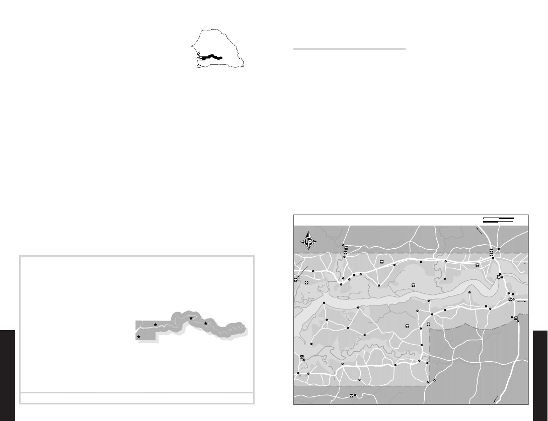
CENTRAL GAMBIA
BINTANG BOLONG
A large, meandering tributary of the Gambia
River, Bintang Bolong rises in Senegal and
joins the river about 50km upstream from
Banjul. The banks of the tidal river are lined
with mangroves, and tucked away among
the maze of shrubs near Bintang is the
spectacular Bintang Bolong Lodge (%4488035,
9867615; www.bintang-bolong.com; r per person D400;
s), an int i mate, ecofriendly camp made
from local mangrove, and clay bricks. It was
renovated in 2004 and now houses up to 16
people in stunning huts that sit on stilts on
the river. If the tide is high, you can almost
leap from your bedroom into a canoe and
go bird-watching or fishing in the man-
groves. The lodge offers boat trips (D800
per hour per boat), as well as plenty of other
activities (visits to the local crocodile pool
where you can get close-up views of baby
crocs are a favourite). It can also arrange
a pick-up from Brikama (D750), Banjul or
Serekunda (D1200) or Soma (D2000).
This is a great, family-friendly place to
explore the natural surroundings of central
Gambia, and catch a glimpse of rural life –
the camp is closely integrated with the local
community, employing villagers and invest-
ing in schools and hospitals.
Getting There & Away
Twice a day there’s a bus from Brikama to
Bintang (D25, one hour). If you can’t face
the wait for the bus to fill up, you can hire
a private taxi (around D1700 to D2000). The
driver needs to follow the main road east
through the village of Somita, and at Killy
turn left (north) along the dirt road to reach
Bintang village and the lodge. Or just phone
the place and arrange to be picked up.
KANILAI
A small village near the Senegalese border,
Kanilai is the hometown of President Jam-
meh. He’s honoured his birthplace and put
it on the tourist map through the construc-
tion of the Sindola Safari Lodge (%4483415/6;
kairaba@gamtel.gm; hut D1020, ste D2040; as)
, a
most luxurious upcountry lodging.
Central & Eastern
Gambia
HIGHLIGHTS
Wake up to the lapping of the waves and
the calls of the birds at Bintang Bolong
( opposite ), where huts stand on stilts in
the river
Take a pirogue from Tendaba to the maze
of mangroves in the Baobolong Wetland
Reserve ( p131 )
Follow in the footsteps of histories old
and new at Georgetown (Jangjang-
bureh; p133 ), where relics of ancient
African and modern European cultures
document different eras
Try your luck at spotting hippos and
chimpanzees on a boat tour to River
Gambia National Park ( p138 )
(Jangjang-bureh)
Georgetown
National Park
River Gambia
Reserve
Baobolong Wetland
Bintang Bolong
ὅὅὅὅὅὅὅὅὅὅὅ
ὅὅὅὅὅὅὅὅὅὅὅ
ὅὅὅὅὅὅὅὅὅὅὅ
ὅὅὅὅὅὅὅὅὅὅὅ
ὅὅὅὅὅὅὅὅὅὅὅ
ὅὅὅὅὅὅὅὅὅὅὅ
ὅὅὅὅὅὅὅὅὅὅὅ
ὅὅὅὅὅ
ὅὅὅὅὅ
ὅὅὅὅὅ
ὅὅ
ὅὅὅὅὅὅὅὅὅ
ὅὅὅὅὅὅὅὅὅ
ὅὅὅὅὅὅὅὅὅ
ὅὅὅὅὅὅὅὅὅ
ὅὅὅὅὅὅὅὅὅὅὅὅὅὅὅὅ
ὅὅὅὅὅὅὅὅὅὅὅὅὅὅὅὅ
ὅὅὅὅὅὅὅὅὅὅὅὅὅὅὅὅ
ὅὅὅὅὅὅὅὅὅὅὅὅὅὅὅὅ
ὅὅὅὅὅὅὅὅὅὅὅὅὅὅὅὅ
ὅὅὅὅὅὅὅὅὅὅὅὅὅὅὅὅ
ὅὅὅὅ
ὅὅὅὅ
ὅὅὅὅ
ὈὈ
ὈὈ
ὈὈὈ
ὈὈ
ὈὈ
ὈὈ
Serekunda (200km)
Santa Su (184km)
(119km); Basse
To Georgetown
(94km)
To Kuntaur
Dakar (250km)
To Kaolack (70km);
Banjul (92km);
To Brikama (56km);
(100km)
Ziguinchor
(75km);
To Bignona
Gambia River
Dumbuntu
Sankandi
Killy
Kunda
Kamamudu
Mangana
Kandion
Tankular
Kanilai
Jasabo
Batelling
Kunda
Janneh
Missira Tenda
Jola
Bintang
Kandiadiou
Sintet
Kemoto
Keneba
Tendaba
Kaiaf
Diganteh
Sénoba
Soma
Yelitenda
Bambatenda
Sabakh
Médina
Katchang
Illiassa
No Kunda
Nja (Njaba)
Gunjur
Saba
Suarra Kunda
Jowara
Saboya
Salikene
Manduar
Sibanor
Bondali
Genieri
Konko
Mansa
Pakali Nding
Farafenni
Kwinella
Kalagi
Bwiam
Kuntair
Kerewan
Kunda
Kinteh
Gambian Border Post
Ruins
Church
Portuguese
Border Post
Senegalese
Forest Park
Pukalu
National Park
Kiang West
Forest Park
Mutaro Kunda
Wetland Reserve
Baobolong
Forest Park
Kumadi
Dobo Forest Park
Forest Park
Kusaywa
Point
Toubab Kollon
Ferry
ong
ol
o B
Ba
ong
Bol
mani
gku
run
Ju
ng
lo
Bo
ng
ta
Bin
S E N E G A L
S E N E G A L
Hwy
ia
mb
s-Ga
an
Tr
CENTRAL GAMBIA
0
10 km
0
6 miles
POPULATION: 450,000
C E N T R A L G A M B I A • • B i n t a n g B o l o n g 129
© Lonely Planet Publications

w w w . l o n e l y p l a n e t . c o m
CENTRAL & E
ASTERN
GA
MBIA
w w w . l o n e l y p l a n e t . c o m
CENTRAL & E
ASTERN
GA
MBIA
Sindola offers the whole dazzling range
of tourist facilities, from tennis and volley-
ball courts to massage parlours and several
bars and restaurants, spread out across a
vast terrain of 30,000 sq metres. Birding
trips and river fishing can be organised, too.
The place owes its name ‘Safari Lodge’ to an
adjoining wildlife park, a rather sad story of
animals in cages. Several large mammals,
including a couple of lions, were acquired
to be ‘put on display’, but died before the
park was completed.
To get here from the coast, you could take
an all-inclusive tour from the Kairaba Hotel
( p108 ), or hire a private taxi (around D3000).
On public transport, take a bush taxi from
Brikama and get off at the police checkpoint
where the highway and the road to Kanilai
meet. Kanilai is 6km further south.
TENDABA
On the southern bank of the Gambia River, the
small village of Tendaba is 165km upstream
from Banjul. The village occupies a place of
honour in the upriver itineraries of many
travellers, thanks to the enduringly attrac-
tive Tendaba Camp (%4541024, 4465288; tendaba@
qanet.gm; bungalows with/without bathroom from D245/
225, VIP r D270)
. Established in the 1970s as a
hunting camp, the hotel is something of a
classic on the travellers scene, providing con-
sistently good accommodation, service and
a range of excursions. Tendaba’s attraction
lies in its position – opposite the Baobolong
Wetland Reserve and in close proximity to
Kiang West National Park – in short, it’s a
bird-watcher’s dream destination.
Accommodation ranges from small bung-
alows to VIP rooms, fully equipped with a
river-edge veranda and TV. The restaurant
gets consistently good reviews – great news,
as there’s hardly anywhere else to go for a
meal in the near surroundings. The bush pig
in pepper sauce is a treat, and the evening
buffets leave you spoilt for choice The camp
frequently organises dance and drumming
shows (donations always welcome).
From Tendaba, you can arrange 4WD ex-
cursions to Kiang West National Park and
boat rides around the creeks of the Baobo-
long Wetland Reserve. If you don’t want to
take a vehicle trip, there are lots of options for
walking in this area. A good destination for
the day is Toubab Kollon Point, about 7km
from the camp (see opposite for details).
Getting There & Away
Many people come to Tendaba Camp as
part of a tour, and most large hotels and
tour operators offer two-day excursions or
THE STATE OF THE ROADS
Two main arteries connect the eastern and western parts of Gambia – the north-bank road, on the
upper side of the river, and the south-bank road, which parallels the Gambia River in the south.
Both roads have been in a terrible state for years, the northern route being a washed-out dirt road,
the southern a potholed stretch of tarred road. The southern connection used to be the better
choice of two dire options, and the route used by most public transport. Yet continuous neglect
has meant that the artery is now so rundown that it’s even worse to drive on than the north-bank
road. Bush taxis frequently drive on improvised dirt tracks beside the road, and Gambia’s formerly
proud bus network has literally been ground to a halt by the sand and stones.
If you’re in your own car take the ferry from Banjul to Barra and travel via the north bank;
your tyres and gearbox will be forever grateful. If you’re travelling by bush taxi, you probably
don’t have much choice but to go via the southern route. From the coast to Brikama the tarred
road is smooth, but the holes start only a few kilometres further down. The stretch from there
to Soma is the worst, and things only really get better shortly before Georgetown. Georgetown
to Basse is miraculously paved, raising hopes that the rest of the artery might be blessed with
a new layer of asphalt, too, though no immediate works had been announced when we visited.
The northern road, by contrast, is supposed to benefit from some fairly imminent improvements –
ask around when you’re there (and let us know!).
Whether you’re going via the northern or southern connection, allow at least 12 hours for the
tedious journey from the coast to Basse Santa Su. And if you want to eschew the treacherous
potholes altogether and experience the scenery at its best, take the boat along Gambia’s smooth-
est east–west connection – the Gambia River.
longer trips. A river tour is a particularly
good idea (see p290 ). Prices differ widely –
it’s worth doing some phoning around before
making your booking. Tours typically in-
clude transport, accommodation, food and
side trips.
Another option is to come from the At-
lantic Coast resorts by green tourist taxi
(about D4000 for the car, carrying up to four
people) and pay for your own room, food
and day trips directly to the camp.
Independent travellers on public trans-
port should take a bush taxi from Banjul
or Serekunda along the main road towards
Soma. Get off at the village of Kwinella; the
camp (signposted) is 5km north along the
dirt road. There are no regular minibuses,
but camp manager Saja Touray promises to
collect anyone from Kwinella for free. Other-
wise it’s a walk or trip by donkey cart.
KIANG WEST NATIONAL PARK
South of the river, and to the west of Tend-
aba Camp, Kiang West National Park (admission
D31.50)
is one of the largest protected areas
in Gambia, and boasts its biggest and most
diverse animal population. Habitats include
mangrove creeks and mud flats (the river is
still tidal this far upstream), plus large areas
of dry woodland and grassland. A major
natural feature is an escarpment, which runs
parallel to the riverbank. We’re not talking
Rift Valley here, but even 20m is significant
in a country as flat as Gambia, and from
this high point you can look over the nar-
row plain between the escarpment foot and
the river itself. Animals are often seen here,
especially at the three water holes.
Kiang is one of the best places in Gambia
to get a close-up look at cute bushbabies.
Other frequently observed mammals in-
clude baboons, colobus monkeys, warthogs,
marsh mongooses and bushbucks. You may
see an antelope called a roan – it’s large and
horselike (hence the name), and migrates
into the area from Casamance. Making very
rare appearances are sitatungas, a larger rel-
ative of the bushbuck that are aquatic and
adept at swimming and moving through
river vegetation using their wide hooves.
Other rarely sighted species include hy-
enas, leopard, manatees, dolphins and croc-
odiles. Birds are also plentiful, with more
than 300 species recorded (see right for bird-
watching tips).
A popular place for viewing wildlife is
Toubab Kollon Point , a river promontory in the
northeast of the park. Behind the point, the
escarpment runs close to the riverbank, and
2km west is a viewing hide overlooking a
water hole, which attracts a good range of
animals, especially in the dry season. Novem-
ber to January are the best months to visit,
but wear pants to avoid being bitten by tsetse
flies. The admission fee is payable at the park
headquarters in Dumbuntu, although this is
included in the price if you’re on a tour from
Tendaba.
BAOBOLONG WETLAND RESERVE
A tributary of the Gambia River, Bao Bolong
rises in Senegal and enters the main river on
the northern side, upstream from Tendaba.
It contains several other bolongs (creeks), as
well as mangroves and salt marshes, which
together with the surrounding dry savannah
woods and grassland make Baobolong Wet-
land Reserve of international importance.
Baob olong is a Ramsar (the international
wetlands convention) site.
The mangroves in this area are some of
the largest in the region, growing over 20m
high in places and forming a virtual forest.
Birds are a major attraction – marshlands
attract large numbers of herons (including
the white-backed night heron) and egrets,
the rare Pel’s fishing owls and mouse-brown
TWITCHER TIPS: KIANG WEST
NATIONAL PARK
With more than 300 recorded species, Kiang
West National Park is one of the richest bird-
ing areas in Gambia, and something of a pil-
grimage site for keen watchers. Even visitors
with little interest in the feathered creatures
have been converted to binocular-wielding
bird spotters, attracted by the sight of the
large Abyssinian ground hornbill, ospreys,
fish eagles, martial eagles and bateleur
eagles. While raptor species are particu-
larly common here, many other varieties,
including the rare brown-necked parrot and
the more common white-rumped swift are
found here. Tendaba Camp has regular ex-
cursions to Kiang West, though for expert
birding advice, you should consider coming
with a specialist guide, and exploring the
area on your own.
130 C E N T R A L G A M B I A • • Te n d a b a
C E N T R A L G A M B I A • • K i a n g W e s t N a t i o n a l Pa r k 131
CENTRAL & E
ASTERN
GA
MBIA
w w w . l o n e l y p l a n e t . c o m
CENTRAL & E
ASTERN
GA
MBIA
sunbirds. The reserve also protects various
aquatic mammal species such as manatees,
clawless otters and marshbucks.
The best way to experience this wonder-
ful maze of islands and waterways is by boat,
which is most easily arranged at Tendaba
Camp.
SOMA & MANSA KONKO
Soma is a junction town where the main
road crosses the Trans-Gambia Hwy, and is
where you change transport if you’re head-
ing upcountry by bush taxi or, crucially, fill
up the tank before continuing your journey
east, where service stations are rare.
Soma is a dusty, flyblown place, with the
main street full of trucks and rubbish, and
nothing in the way of attractions. The border
is only a few kilometres to the south, and the
Gambian customs and immigration post is
on the eastern edge of town. About 10km
north of Soma is Yelitenda, where you catch
the ferry across the Gambia River to Bamba-
tenda, and then continue to Farafenni.
Near Soma is Mansa Konko, originally
an important local chief’s capital (the name
means ‘king’s hill’), and then an administra-
tive centre during the colonial era. Today it’s
a sleepy ghost town with a few reminders of
the glory days, such as the district commission-
er’s residence and the crumbling colonial villa.
Sleeping & Eating
Moses Guesthouse (%4531462; r per person D125)
If you get stuck in Soma, this lively place
on the north side of the main junction is
the best option. Since it’s the most popular
place in a busy junction town, it can get
quite noisy, but then again, it comes with
the added attraction of 24-hour electricity.
Government Resthouse (s/d D150/250) This place
in Mansa Konko is officially for government
staff only, but desperate travellers can stay
in the usually clean rooms. It’s 2.5km from
the main road near the old district commis-
sioner’s residence, which is the highest point
for several kilometres around with some fine
views over the Gambia River valley; the resi-
dence is also where to go if there’s no-one
around at the resthouse.
Getting There & Away
Most bush taxis from Serekunda terminate
at the bush-taxi park in Soma’s centre (the
fare is D90) or go on to Farafenni (D100
from Serekunda). Transport to Georgetown
(D80) and Basse Santa Su (D90) leaves from
the same park. Heading south, you can also
get bush taxis from the border to Bignona
and Ziguinchor in southern Senegal.
If you’re heading north from Soma, take a
local bush taxi to the Gambia River ferry at
Yelitenda (D6), go across as a foot passenger
(D5), and take one of the vehicles waiting
on the northern bank at Bambatenda to Fara-
fenni (D6), where you can find transport to
Kaolack or Dakar. The ferry service oper-
ates between 8am and 9pm, usually every
half-hour, though waits can be longer, and
the ferry suffers fairly frequent breakdowns.
Tickets can be bought about 1km before you
reach the ferry – anyone can indicate the
office to you. Taking your own car across will
cost around D65 – exact rates often depend
on the mood of the official you happen to
encounter on the day. You’ll probably have
to wait a while for a place, but it’s not as bad
as the Banjul to Barra ferry.
If you’re on foot, you can also jump onto
a pirogue (D4). Pirogues leave when they’re
full. You’ll have pay another D4 for access
to the port. A private pirogue should cost
about D80.
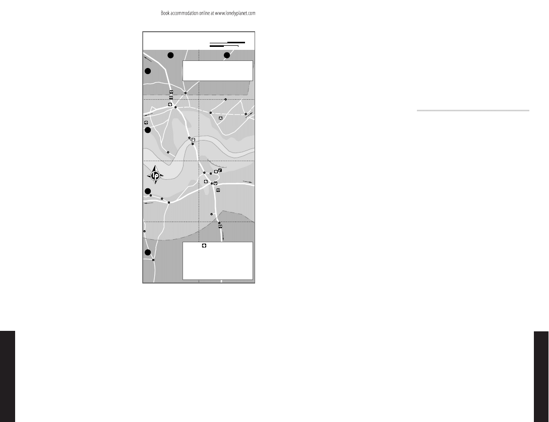
FARAFENNI
Situated on the Trans-Gambia Hwy north of
the Gambia River, Farafenni is a busy little
town and much more pleasant than Soma.
People come from surrounding villages and
merchants come from as far as Mauritania
and Guinea to sell their wares at the main
Sunday lumo (market). This is a good place
to sample upcountry life, although it feels
more like Senegal than Gambia: CFA francs
are used more than dalasi, and more French
is spoken than English. If you’re low on cash
visit the Trust Bank (%5735238; fax 5735007); it’s
the only bank for many kilometres. The Sen-
egal border, 2km to the north, is open from
7am to midnight.
If you do get stuck here, it’s worth tak-
ing the dirt road 10km east to Kataba Fort.
Though reduced to its dusty foundations,
this 1841 Wolof construction tells a half-
forgotten story of old African kingdoms.
Sleeping & Eating
Eddy’s Hotel & Bar (%7735225; s/d with bathroom D200/
250; a)
This place has been a popular travel-
lers’ meeting point for many years. You can
eat chicken and chips or benechin (rice in a
thick sauce of meat and vegetables) for in the
shady garden courtyard (D35 to D45) while
the apparently carefree Eddy shoots (un-
successfully) at small birds with an air gun.
Self-contained rooms come with either twin
or double beds; note that room rates nearly
double if you request air-con. There’s also safe
parking, cold beer and a disco at weekends.
For cheap food, there are several chop
shops (local restaurants) on the main street,
south of the junction.
Getting There & Away
If you’re heading for Banjul, direct mini-
buses from Farafenni go to Serekunda most
mornings for D90. If you’re heading south
or anywhere upcountry on the southern
bank, you have to go to Soma and change.
If you’re heading for Dakar there are bush
taxis for CFA4000; some go from Farafenni
itself, but most go from the Senegal side
of the border. A minibus from the bush
taxi stop in Farafenni to the Senegal border
post is D5.
EASTERN GAMBIA
Beyond Farafenni is the Gambia River’s tran-
sition zone – the area where it changes from
saline to fresh water. The character of the
river is also different: the tidal change is less
noticeable, the mangroves thin out and thick
forest grows down to the water’s edge. And
you’ll increasingly notice islands on the river,
the most famous being Baboon Island, which
is part of the River Gambia National Park.
As you head up the river there are several
colonial-era towns. Georgetown and Basse
Santa Su are both well worth visiting, as are
the Wassu Stone Circles, enigmatic relics of
an entirely different era.
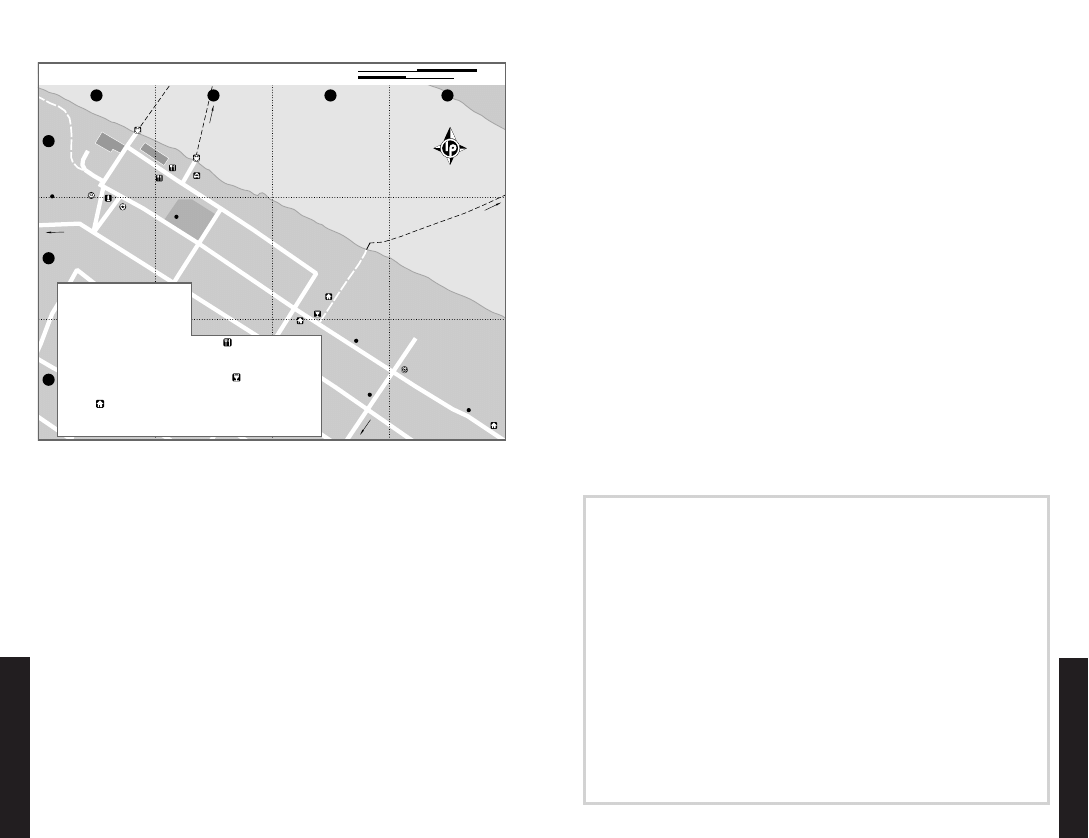
GEORGETOWN (JANGJANG-BUREH)
Under the British, Georgetown was a busy
administrative centre and trading hub full
of grand buildings. Today it has a new (or
should that be old?) name, a host of crum-
bling monuments to history and the sort of
sluggish atmosphere that discourages all but
the most necessary work – it’s the perfect
place to relax for a couple of days.
Located on the northern edge of Mac-
Carthy Island in the Gambia River, about
300km by road from Banjul, the traditional
and now officially reintroduced name for
the town and island is Jangjang-bureh, but
most people still call it Georgetown. The is-
land is 10km long and 2.5km wide, covered
with fields of rice and groundnuts, and has
ferry links to both riverbanks. There is little
in terms of infrastructure – no banks, no
hospital – but thereʼs an Internet café (per hr
D25; h9am-6pm)
for those who feel they need
a connection beyond the island.
While in Georgetown, or even on the
ferry taking you there, you’ll undoubtedly
be approached by persistent local youths of-
fering their services as guides. Unless you’re
very directionally challenged you won’t need
their help; don’t be afraid to say no.
ὅὅὅὅὅὅὅὅ
ὅὅὅὅὅὅὅὅ
ὅὅὅὅὅὅὅὅ
ὅὅὅὅὅὅὅὅ
ὅὅὅ
ὅὅὅ
ὅὅὅ
ὅὅὅὅὅὅὅὅὅὅ
ὅὅὅὅὅὅὅὅὅὅ
ὅὅὅὅὅὅὅὅὅὅ
ὅὅὅὅὅὅὅὅὅὅ
ὅὅὅὅὅὅὅὅὅὅ
ὅὅὅὅὅὅὅὅὅὅ
Ὀ
Ὀ
4
3
2
1
Su (184km)
Basse Santa
(119km);
To Georgetown
Ziguinchor (180km)
To Bignona (153km);
(94km)
To Kuntaur
(70km);
Dakar (250km)
To Kaolack
To Barra (104km)
Banjul
(134km);
To Brikama
(170km)
S E N E G A L
SENEGAL
Fula
Sukoto
Médina
Sabakh
Hwy
Bambatenda
Pakali
Yelitenda
Trans-Gambia
Wollof
Dipa Kunda
MBallo
Jamal
Balingho
Farafenni
Konko
Soma
Nding
Kaiaf
Diganteh
Sénoba
Njolfen
Genieri
Massembe
Ndiamakouta
Mansa
Border Post
Senegalese
Border Post
Gambian
Post
Border
Gambian
Border Post
Pakala
Forest Park
Point
Devil
m
Ga
er
iv
bia R
1
7
3
2
5
6
4
7
6
TRANSPORT
5
4
3
SLEEPING
2
1
SIGHTS & ACTIVITIES
Ferry................................................
A2
Bush Taxi & Minibuses...................... B3
Moses Guesthouse........................... B3
Government Resthouse.................... B3
Eddy’s Hotel & Bar...........................
A2
Kataba Fort....................................... B2
District Commissioner’s Residence..(see 1)
Colonial Villa.................................... B3
B
A
& FARAFENNI
SOMA, MANSA KONKO
0
8 km
0
4 miles
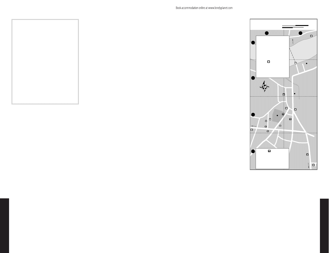
E A S T E R N G A M B I A • • G e o r g e t o w n ( J a n g j a n g - b u re h ) 133
132 C E N T R A L G A M B I A • • S o m a & M a n s a K o n k o
w w w . l o n e l y p l a n e t . c o m
CENTRAL & E
ASTERN
GA
MBIA
w w w . l o n e l y p l a n e t . c o m
CENTRAL & E
ASTERN
GA
MBIA
Sights
It may only take you a couple of hours to
wander around Georgetown, but there is
probably more to see here and in the sur-
rounding area than in almost any other
town in Gambia. Most of the ‘sights’ have
a historical bent; two of the most interest-
ing are crumbling late-Victorian warehouses
situated on the waterfront either side of the
northern ferry landing. Enterprising local
youths have created a local ‘Roots industry’
from the structures. It started with one of
the warehouses being referred to as ‘Slave
House’, which was then changed to ‘Slave
Prison’; the place was then decorated with
lit candles and a matching story was created.
A ‘Freedom Tree’, claimed to guarantee lib-
eration to any slave who touched it, another
‘Slave House’ and finally a ‘Slave Market’
joined the scene. Although records show
slaves were transported through George-
town, it is unlikely that the buildings were
used in this trade as they were built well
after slavery was abolished in British colo-
nies in 1807. You might find this profitable
rewriting of history an insult to the victims
of slavery, or think of it as entertainment.
Your choice – but be aware of the ‘Visitors
Book’, encouraging incredibly generous
donations in the memory of slavery.
Nearby is the old Commissioner’s Quarters
now inhabited by the district governor, and
a monument to Fort George outside the police
station. The fort was built by the British in
1823 after the local king asked for their pro-
tection against a neighbouring tribe. West of
town is the Armitage High School, a historical
building of vague interest to anyone keen on
colonial architecture.
Those with a penchant for ancient histor-
ical features should take a trip to Lamin Koto
Stone Circle. Itʼs a smaller and less impressive
monument than the famous Wassu Stone
Circles, but sitting only 1.7km away from
the north bank, itʼs closer and thus in good
reach for those who can’t make it to Wassu.
The circle is on the right (northeast) side of
the road, under a big tree.
Tours
Georgetown is an excellent base for pirogue
tours and birding trips as well as for day
visits to the Mungo Park memorial at Karan-
taba Tenda, the River Gambia National Park,
the Wassu Stone Circles and the Dobo and
Kunkilling Forest Parks.
Most of the camps in Georgetown organ-
ise tours, and prices are roughly the same.
Expect to pay D3500 per pirogue for day
trips to the River Gambia National Park
and D4000 for the double deal of a visit to
Wassu and the River Gambia National Park.
Baobolong Camp offers two-day boat trips
to Karantaba Tenda (including on-board ac-
commodation, D8000). Circumnavigations
of MacCarthy Island also make for a good
day out (per pirogue D1300).
Georgetown sees a lot of visitors inter-
ested in bird life, and most camps run bird-
ing excursions. The ones offered by the Bird
Safari Camp are particularly recommended.
Bird Safari Camp and Jangjang-bureh Camp
are the best providers for river excursions.
Sleeping
Baobolong Camp (%5676133; fax 5676120; Owens St;
s/d D300/400)
This is the best-functioning place
in Jangjang-bureh itself – the luxury of a
generator is a good indicator. It’s set in lush
gardens near the river at the eastern end of
town. The camp attracts plenty of birds, and
some of the various pirogue tours on offer
are particularly geared towards twitchers.
Bird Safari Camp (%5676108; fax 5674004; www
.bsc.gm; r with half board per person D1000; s)
Some
2.5km west of a tiny island town, this place
is about as secluded as it gets. Accommo-
dation is in bungalows or luxury tents with
bathroom. It has a generator, which you’ll
appreciate after dark. A resident ornitholo-
gist, private hides and guided walks make it
a favourite with bird-watchers. To get here
from central Georgetown, you can either
hire a taxi or call to arrange a pick-up. This
camp is on the itinerary of Hidden Gambia
river trips (see p290 ), and can be reached by
river as part of its tour.
Jangjang-bureh Camp (%/fax 5676182, 9920618;
www.gambiariver.com; r per person D200)
This rootsy
place on the north bank of the Gambia
River consists of an eclectic collection of
rustic bungalows set in a mazelike garden.
Lighting is by oil lamps, and a drink at the
bar overlooking the river is a fine way to
ὅὅ
ὅὅ
ὅὅ
ὅὅ
ὅ
ὅὅὅ
ὅὅὅ
ὅὅ
ὅὅ
ὅὅ
ὅὅ
ὅὅ
ὅὅ
ὅὅὅὅὅὅὅὅὅὅὅὅὅ
ὅὅὅὅὅὅὅὅὅὅὅὅὅ
ὅὅὅὅὅὅὅὅὅὅὅὅὅ
ὅὅὅὅὅὅὅὅὅὅὅὅὅ
ὅὅὅὅὅὅὅὅὅὅὅὅὅ
ὅὅὅὅὅὅὅὅὅὅὅὅὅ
ὅὅὅὅὅὅὅὅὅὅὅὅὅ
ὅὅὅὅὅὅὅὅὅὅὅὅὅ
ὅὅὅὅὅὅὅὅὅὅὅὅὅ
ὅὅὅ
ὅὅὅ
ὅ
ὅ
ὅὅ
ὅὅ
To Soma
Banjul
(200km)
(10km);
Gambia River
Maka-Gouye
Kuntaur
Wassu
Kudang
Njau
Charmen
Sotokoi
Jane Kunda
Balanghar
Ker Nderry
Kau-ur
Yoro Beri
Kunda
Sankuli Kunda
Georgetown
Jarume
Koto
Manna
(Jangjang-bureh)
Bansang
Médina Yorofoula
Pata
Kunting
Piniai Fula
Kunda
Pakali Ba
Baro Kunda
Sutukung
Bureng
Dankunka
Ngeyen
Sanjal
Sara Kunda
Sambang
Jappeni
Jassong
Bambali
Brikama Ba
Wassu Stone
Circles
Lamin Koto
Stone
Circle
River Gambia
National
Park
Island
MacCarthy
Island
Baboon
long
Sof
iny
ama
Bo
S E N E G A L
Kunkiling
Forest
Park
Dobo
Forest
Park
EASTERN GAMBIA
ὅὅ
ὅὅ
ὅὅ
ὅὅ
ὅὅ
ὅὅ
ὅὅ
ὅὅ
ὅὅ
ὅ
ὅ
ὅὅ
ὅὅ
ὅὅ
ὅὅ
ὅὅ
ὅὅὅ
ὅὅὅ
ὅ
ὅ
ὅὅ
ὅὅ
ὅὅ
ὅὅ
ὅὅ
ὅὅ
ὅ
ὅ
ὅὅ
ὅὅ
ὅὅ
ὅὅ
ὅὅ
ὅὅ
ὅὅ
ὅὅὅὅὅ
ὅὅὅὅὅ
ὅὅὅὅὅ
ὅὅὅὅὅ
ὅὅ
ὅὅ
ὅὅ
ὅὅ
ὅὅ
To
Tambacounda
(45km)
To Médina
Gounas (30km)
Kolda (160km)
To Vélingara (40km);
Ri
ia
Gamb
ver
Maka
Nétéboulou
Brifu
Koina
Sutukoba
Kunda
Badja
Fatoto
Kunda
Kantale
Manda
Garowal
Kulari
Yarobawal
Darsilami
Mansajang
Santa Su
Basse
Diabugu
Bakadaji
Alohungari
Njallal
Karantaba
Tenda
Karantaba
Tabokoto
Sare Sofi
Sare Bojo
Badiara
Sabi
Gambissara
Tabanani
Douta Bassi
Mungo Park
Memorial
S E N E G A L
30 km
20 miles
0
0
E A S T E R N G A M B I A • • G e o r g e t o w n ( J a n g j a n g - b u re h ) 135
134 E A S T E R N G A M B I A • • G e o r g e t o w n ( J a n g j a n g - b u re h )
w w w . l o n e l y p l a n e t . c o m
CENTRAL & E
ASTERN
GA
MBIA
w w w . l o n e l y p l a n e t . c o m
CENTRAL & E
ASTERN
GA
MBIA
spend the evening. It’s an old favourite with
travellers and belongs to the Gambia River
Experience – naturally, there’s an enticing
range of boat trips on offer.
Dreambird Camp (%/fax 5676182; r per person D200)
This is mainly the embarkation point for the
transfer boat to Jangjang-bureh Camp (free
to guests and diners). It also has a few rooms,
but these had collapsed when we visited. It
was hard to tell whether they would be open
again soon; no-one seemed inclined to make
any specific statements – not a good sign…
Alaka-bung Lodge (%5676123; alakabung@qanet
.gm; Owens St; r per person D100)
This low-key hostel,
Georgetown’s cheap and cheerful option,
attracts a local clientele and has email access
(but not always reliable generator power).
Eating & Drinking
Few options exist outside the camps and
lodges, especially after dark, when George-
town drowns in darkness and life retreats
behind compound walls.
Talamanca Restaurant (%9921100; Findlay St,
meals from D100; h11am-8pm)
A relaxed spot run
by the enterprising young Banna Kongira,
who’s so keen he’ll open after hours if hun-
gry guests knock on his door. He also seems
to be growing his humble restaurant into a
‘hotel’, having added a low-key, mosquito
net–fitted bungalow. Inquire about rates.
There are a couple of cheap eateries
around the market, as well as the following:
Maradona Roadside Pub (Owens St; snacks from D75;
hlunch & dinner) Opposite Alaka-bung Lodge; a good
place for snacks. Has a cheap bar.
Yaa Olly’s Restaurant (Findlay St; meals D100-150;
hlunch & dinner) An unpretentious address for cheap
local meals.
Getting There & Away
Ferries reach MacCarthy Island from either
the southern or northern bank of the river.
The northern ferry operates from 8am to
7pm. The ferry connecting the island to
the southern shore seems to run until de-
mand dries up. We crossed onto the island
at 11pm, while other travellers report the
service inoperative after 6pm. Best to get
there early. The main road between Banjul
and Basse Santa Su does not go directly past
the southern ferry ramp, but bush taxis turn
off to drop off or pick up passengers here
if you ask them. Ferry crossing costs D50/5
for cars/passengers. On the island, pick-ups
take people to Georgetown for D10.
When leaving Georgetown, take a local
pick-up to the southern ferry, and cross over
to the southern bank. You may find a direct
minibus to Basse Santa Su for D10. Alterna-
tively, take a local minibus or bush taxi to
Bansang (D5) and change here for transport
to Basse Santa Su (D5). If you’re heading
west, go to Bansang or just to the main road.
From there you can get to Soma, then change
for Banjul and other destinations.
WASSU STONE CIRCLES
The area between the Gambia River and the
Saloum River in southern Senegal is noted
for its concentration of stone circles; the
group at Wassu, 20km by road northwest of
Georgetown and about 2km north of Kun-
taur, is a particularly good example.
There are several circles (admission D30) each
consisting of between 10 and 24 reddish-
brown, massive stones, 1m to 2.5m high and
weighing several tonnes. Most of the region’s
circles date from AD 500 to AD 1000, be-
fore the Mandinka people migrated to this
area. Excavations have unearthed human
bones and artefacts at the centre of many
circles, indicating that they were burial sites,
although dating techniques show that bodies
may have been buried after the circles were
constructed. Little else is known about the
people who built these structures. Theories
suggest they were farmers because all the
sites are near rivers; but some are buried
with spears, suggesting they were hunters.
The caretaker will show you to a small
but well-presented museum with exhibits
discussing the possible origins of the circles.
It has to be said that not everyone will find
them a major attraction. Go if you want to
see evidence of ancient African cultures, but
not if you’re expecting Stonehenge.
Getting There & Away
The stone circles are about 500m before the
village of Wassu, coming from Georgetown.
In theory Wassu can be reached from Fara-
fenni, but transport can be hard to come
by; most people come from Georgetown. A
bush taxi to Wassu (D25) waits most morn-
ings at the north-bank ferry ramp, but this
goes only when full (which can take several
hours), and even if you reach Wassu in time
there might be nothing coming back. Bush
taxis are only an option on Monday, the day
of Wassu’s colourful lumo, when they are
more frequent. Otherwise it’s safer to hire
a private taxi for the day (around D700), or
jump on a tour with a Georgetown camp.
1
3
2
D
B
A
C
Ferry Pier (2km)
To Southern
Wassu (20km); Kuntaur (22km)
Lamin Koto Stone Circle (1.7km);
To Bush Taxis to Wassu & Kuntaur (200m);
Camp (2.5km)
Bird Safari
School (300m);
To Armitage High
Gambia River
Tower
Water
Market
Camp (1km)
Boat to Jangjang-bureh
Passenger Ferry
Car Ferry
Owens St
Ingram St
Queen St
M
ercer St
Jackson St
Owens St
Findlay St
5
6
13
1
3
16
2
4
10
8
9
12
11
7
14
15
16
15
14
TRANSPORT
13
DRINKING
12
11
EATING
10
9
8
SLEEPING
7
6
5
4
3
2
SIGHTS & ACTIVITIES
1
INFORMATION
Taxis to Southern Ferry Pier........
B1
Passenger Ferry to North Bank....
B1
Car Ferry to North Bank.............
A1
Maradona Roadside Pub............
C2
Yaa Olly's Restaurant.................
B1
Talamanca Restaurant................
B1
Dreambird Camp.......................
C2
Baobolong Camp.........................
D3
Alaka-bung Lodge.......................
C3
Monument to Fort George...........
A2
(‘Slave House’)........................
A1
Late-Victorian Warehouse
Late-Victorian Warehouse............ A1
Commissioner's Quarters............. A1
Project.....................................
C3
Central River Division Forestry
Bird Safari Camp Office................
C3
Internet Café...............................
D3
GEORGETOWN (JANGJANG-BUREH)
0
200 m
0
0.1 miles
THE CENTRAL RIVER DIVISION FORESTRY PROJECT
Deforestation is one of the greatest environmental dangers in Gambia, so it’s encouraging to hear
of the initiatives of the Central River Division Forestry Project
(CRDFP; %5676198; www.crdfp.org)
.
This inspiring environmental programme has been active in educating the local population about
the importance of keeping forests intact, and has in the process created a series of excellent ecotrails
through the remaining woods of central and eastern Gambia. One of these leads through the tiny
Dobo Forest Park
, a
34.5-hectare gallery forest that winds along the north bank of the Gambia River,
not far from Bansang, and boasts an array of wildlife, including crocodiles, antelopes, bushbucks,
hippos and bushbabies, as well as various bird species such as eagles, kingfishers, bee-eaters, rollers
and woodpeckers.
The Kunkilling Forest Park
on the south bank near Bansang is a much larger affair, and can
either be walked through or explored by donkey cart. Its 200 hectares of riparian canopy forest are
jointly managed by four neighbouring villages. Four ecotrails wind through rich woodlands (where
more than 40 types of trees have been counted) inhabited by more than 185 bird species (among
them African finfoots, white-backed vultures, adamawa turtle doves, shining-blue kingfishers and
nightjars), monkeys, manatees and hippos. A guided visit will also take a brief historical detour,
past the tomb of the 19th-century king of Fouladou, Musa Molo.
The CRDFP in Georgetown arranges highly recommended guided tours to these parks. And if a
one-day exploration isn’t enough for you, you can stay in one of the CRDFP’s well-equipped rooms,
and get more deeply involved in their preservation work. (The CRDFP is funded by GTZ and KfW.
The DFS is the commissioned consultancy company for implementing the project.)
136 E A S T E R N G A M B I A • • G e o r g e t o w n ( J a n g j a n g - b u re h )
E A S T E R N G A M B I A • • W a s s u S t o n e C i r c l e s 137
w w w . l o n e l y p l a n e t . c o m
CENTRAL & E
ASTERN
GA
MBIA
CENTRAL & E
ASTERN
GA
MBIA
RIVER GAMBIA NATIONAL PARK
South of Kuntaur, five islands in the Gam-
bia River are protected as a national park.
Its heart is so-called Baboon Island – the
name is sometimes used to refer to the
entire park – the site of a project (privately
initiated but now government-owned) that
takes chimpanzees captured by illegal trad-
ers and rehabilitates them to live in the
wild. Boat trips are available, but visitors
are not allowed to land or get close to the
islands. This is partly because it interferes
with the rehabilitation process, but mainly
because the chimps (there are more than
60) are nervous about humans getting too
close. While females and young ones may
be docile, the males can be quick to attack.
Having lost their fear of people, they are
more aggressive than ‘wild’ chimps and,
being several times stronger than humans,
they’re capable of awesome deeds when
riled. If they are not able to get at the ob-
ject of their frustration, they will often vent
their spleen on the females and youngsters
of their own troop. Because of the dense
cloak of gallery forest on the banks of the
island, it is difficult to see chimps, and get-
ting in close might result in your boat being
boarded by a bristling alpha male.
If you visit the area, it’s best to go with
the aim of having a good day out on this
beautiful stretch of river. You’ll quite likely
see baboons and monkeys, and possibly
crocs and hippos too, plus an excellent
selection of birds. And if you do happen to
see any chimps – while keeping a responsible
distance – it will be a bonus.
Getting There & Away
You can take a boat tour from Georgetown;
several camps there have boats for hire at
D1000 per day. Alternatively, you can go to
Kuntaur by road and hire a boat from there.
Several people provide the service; the going
rate is about D250 for a three- or four-hour
trip (after some bargaining). Boats are only
permitted on the main channel between the
islands and the east bank of the mainland,
and are not allowed to approach the islands
nearer than midstream. Boatmen often try
to please their passengers by getting closer,
but this should be discouraged.
MUNGO PARK MEMORIAL
Historians may want to head for Karantaba
Tenda, about 20km east of Georgetown.
Near this village, on the river bank, is the
memorial pillar marking where the Scottish
explorer Mungo Park set off into the interior
to trace the course of the Niger River.
A bush taxi comes here most mornings
from the north-bank ferry ramp opposite
Georgetown but if your time is limited, hir-
ing a private taxi may be the only certain
way of getting there and back in a day
(around D250). The pillar is outside the vil-
lage, but local boys will guide you there for
a small fee. Another option is to go by boat.
You can hire one for the day from places in
Georgetown from about D1000.
BANSANG
Music-lovers may know Bansang as the mid-
dle name of one of Gambia’s greatest kora
players – Amadu Bansang Jobarteh hails
from here. A pilgrimage to his birthplace
will introduce you to a large town spread
out between the river and the main road. It’s
a calm area that invites walking, particularly
if you’re a keen bird-watcher – spectacu-
lar red-throated bee-eaters nest in a nearby
quarry. And, quite importantly, Bansang
also has the largest upcountry hospital.
BASSE SANTA SU
Set on a beautiful waterfront, Gambia’s east-
ernmost main town is the last major ferry-
crossing point on the Gambia River and an
area transport hub. It’s a traditional trading
centre, as crammed, busy, run-down and
enterprising as any West African junction
town, especially if you come on a Thursday,
when the market is in full swing.
Both Trust Bank (%5668907; fax: 5668907) and,
opposite, Standard Chartered Bank (%4668218)
are in the town centre, on the road to George-
town. They have branches in Basse that can
advance money to Visa cardholders. You
can make calls at the Gamtel Office (%4229999;
gen-info@gamtel.gm)
, opposite the post office,
and possibly connect to the Internet, too, by
the time you visit.
Sights & Activities
Most of Basse can be explored in an afternoon
stroll, which should definitely include the
town’s bustling market and a walk along the
waterfront. Heading for the ferry terminal,
you’ll see an imposing colonial warehouse
on the riverside. A couple converted this
building several years ago into the cul-
tural centre and café Traditions (%5668533;
sulaymanjallowtraditions@yahoo.com; h9am-6pm)
.
They exhibited and sold locally fabricated
crafts including handmade clothes, mats
and wall hangings, sewn from beautiful in-
digo, tie-dyed and mud-dyed cloth. Since
they have left, the place has started gather-
ing dust; the café as well as the display
spaces were neglected when we visited. But
the staff is still immensely enthusiastic and
optimistic that this major stopping point of
any tour to Basse will shine once again.
Even if you find Traditions devoid of
activity, a trip here is rewarding. The bal-
cony gives a great view across the river
and ferry station, and, between June and
February, it’s also one of the best places in
Gambia to see the Egyptian plover, a rare
species, known locally as the crocodile bird.
This small wader might be missed when
standing quietly on the riverbank, but it is
instantly recognised in flight by its swept-
back wings and beautiful black-and-white
markings.
Boat rides to see this and other birds (with
a chance of spotting hippos or crocodiles)
can be arranged with local boatmen on the
waterfront, but rates are fiercely negotiable.
Expect to pay about D300 an hour for a
motorboat (although a lot depends on how
much time the engine is actually running)
or less for a paddled canoe.
Sleeping & Eating
Staying the night in Basse can feel like a pun-
ishment if you’re not used to roughing it a
bit. Places that were once acceptable are now
barely inhabitable – the end of the national
bus service has meant that Basse has been
almost totally deserted by tourists.
Fulladu Camp (%5668743; r per person D300) On
the north bank of the Gambia River this is
undoubtedly the best place to stay. It sits
about 100m from the ferry landing on a large
terrain and has accommodation in comfort-
able bungalows. The management organises
pirogue trips (prices negotiable) and shuttles
you across the river if you call in advance.
The restaurant here regularly gets good re-
views, and is the best bet for eating in town.
HIGHLY STRUNG HIPPOS
The best time to see hippos is at low tide,
when the shallower water cannot hide
them so well. If you see a hippo, admire
it from afar. These giants of the river are
notoriously cantankerous creatures. Forget
lions, leopards and snakes – hippos are
responsible for more deaths in Africa than
any other animal. Despite being vegetarian,
they frequently kill animals and people with
their enormous jaws and 60cm-long teeth –
not to eat them, but to protect their living
space. Hippos are very territorial and short-
sighted, and will plough into anything they
consider a threat, including, unfortunately,
the occasional boat with camera-wielding
tourists. Keep a respectful distance and,
naturally, don’t try to feed them by throwing
food towards their chomping jaws.
4
3
2
1
(360km)
(125km);
Labé (Guinea)
Tambacounda
Sutokoba (22km)
To Yarobawal (10km);
Vélingara (20km)
To Sabi (7km);
Banjul (375km)
Soma (192km);
(65km);
To Georgetown
Dry Market
Gambia River
4
1
10
14
13
5
11
12
6
9
7
8
3
2
14
13
TRANSPORT
12
11
DRINKING
10
9
8
7
6
SLEEPING
5
4
SIGHTS & ACTIVITIES
3
2
1
INFORMATION
Ferry................................
B2
Bush-Taxi Garage............
A2
Plaza Nightclub................
A3
Kassoumai Bar..................
B3
Plaza Hotel.......................
B3
Jem Hotel..........................
B4
Fulladu Camp..................... B1
Basse Guesthouse.............. B3
Apollo Hotel......................
A3
Traditions........................... B2
Market..............................
A3
Trust Bank.........................
A3
Standard Chartered Bank...
A3
Gamtel Office....................
A3
B
A
BASSE SANTA SU
0
200 m
0
0.1 miles
138 E A S T E R N G A M B I A • • R i v e r G a m b i a N a t i o n a l Pa r k
E A S T E R N G A M B I A • • B a s s e S a n t a S u 139
CENTRAL & E
ASTERN
GA
MBIA
w w w . l o n e l y p l a n e t . c o m
CENTRAL & E
ASTERN
GA
MBIA
Jem Hotel (%5668356; s/d D300/600) When we
visited, the manager of this place off the
road to Vélingara was a boy who’s been in
charge since his father’s death and is doing
a good job, though running this hotel-
restaurant-nightclub is clearly tough. It’s
still one of the cleaner Basse options and
the restaurant (open for lunch and dinner
with meals around D100 to D150) is a
bright spot. Phone in advance for meals.
Basse Guesthouse (%5668283; r D150) Has
dingy rooms with shared toilets, but you
can spend hours people-watching from the
1st-floor balcony above a tailor shop.
The Apollo Hotel (%57000852; r D100), west
of the market, and Plaza Hotel (r D100), east
of Basse Guesthouse, are run (and largely
inhabited) by young men. Neither place is
ideal for women; they’re equally shoddy.
Traditions (%5668533; r D250) can dust off the
apartment of the former manager for unex-
pected visitors (D250). It also serves food;
announce your eating plans in advance.
The state of hotels apart from those
mentioned often indicates the standard of
restaurants. You guessed it, there aren’t
many options in Basse. For local meals,
you’re pretty well served at the chop shops
around the taxi park. If you arrive late at
night they might be closed, and you’ll be
grateful for the roast-meat stalls that line
the main road west of the market.
Drinking & Entertainment
The Jem Hotel nightclub promises ‘London
sounds’, but the manager admitted that the
sign was old. Still, it gets busy with young-
sters bopping to reggae, hip-hop and African
music on occasional weekends. The Kas-
soumai Bar opposite the market used to be
a busy weekend spot; it’s still active, though
the quality has since declined. The Plaza
Nightclub near the market gets packed on
weekends. Otherwise it’s back to the street
meat stalls, beer in hand, where you can
count on the company of locals.
Getting There & Away
Bush taxis go to the eastern outpost of Fatoto
(D20, 40 minutes), the ferry ramp for George-
town (D75, one hour); Soma (D150, four
hours) and Serekunda (D300, eight hours).
The ferry to the Gambia River’s northern
bank takes one car at a time, and the journey
is quick. The charge for a car is D50; passen-
gers are D5. There are smaller boats taking
passengers across; the fare is D10.
If you’re heading for Senegal, you can go
by bush taxi to Tambacounda via Vélingara.
If your horizons are even further afield a
sept-place taxi goes more or less daily (pas-
sengers depending) to Labé in northern
Guinea. The fare is CFA30,000 and the trip
takes at least 24 hours (or longer if there are
delays at roadblocks).
MUNGO PARK
By the end of the 18th century, the incentive for exploring the interior of West Africa had switched
from being commercial to ‘scientific’ (and evangelical – to convert ‘heathens’ to Christianity).
Scientific exploration was based on solving two main puzzles: the position of Timbuktu (the
mysterious ‘city of gold’) and the route of the Niger River. Although the Niger’s existence was
well known, its source and mouth, and even the direction of its flow, were a mystery.
In 1795 the London-based Association for Promoting the Discovery of the Interior Parts of
Africa sent a young Scotsman called Mungo Park to the Gambia River. Park followed the river
upstream by boat, sailing between British trading stations. He based himself near present-day
Georgetown, where he learnt several local languages, and then set off across the plains, with
just two servants and three donkeys. He travelled northeast, crossing the Senegal River, getting
captured and escaping, and eventually reached the Niger at Ségou, confirming that it flowed in
a northerly direction. After more adventures and incredible hardships, he eventually managed to
return to the Gambia River and to Britain, where he wrote Travels in the Interior of Africa.
In 1801 Park returned to the Gambia River and again set out for the Niger. This time he took a
larger support crew, although most of the men were army deserters and completely unprepared
for the rigours of the expedition. By the time the group reached the Niger River, many had
died, and even more perished either from disease or attacks by local people as they took a boat
downstream. Park and the few remaining members of his party all died under attack at the Bussa
Rapids, in the east of present-day Nigeria.
140 E A S T E R N G A M B I A • • B a s s e S a n t a S u
© Lonely Planet Publications. To make it easier for you to use, access to this chapter is not digitally
restricted. In return, we think it’s fair to ask you to use it for personal, non-commercial purposes
only. In other words, please don’t upload this chapter to a peer-to-peer site, mass email it to
everyone you know, or resell it. See the terms and conditions on our site for a longer way of saying
the above - ‘Do the right thing with our content.’
© Lonely Planet Publications
141
Wyszukiwarka
Podobne podstrony:
EV FC A050 2219 v1 m56577569830728268
EV HB 6600 2347A v1 m56577569830647953
SI-0061A-002-POL v1 m56577569830688968
EV FC M590 2926B v1 m56577569830696742
EV FC 2200 2199 v1 m56577569830612388
EV ST 6700 2936B v1 m56577569830799963
EV HB RM60 QR 2434A v1 m56577569830647992
EV FC 2200 2199 v1 m56577569830612388
SI 0031A TLCN40 en v1 m56577569830607100
EV HB M580 2343A v1 m56577569830646677
SI 0086A 001 POL v1 m56577569830696663
SI 0037A 002 POL v1 m56577569830696736
EV BR M575 R 2885C v1 m56577569830667247
SI 8FL0A 001 POL v1 m56577569830672959
SI 6S80A 003 POL v1 m56577569830679772
więcej podobnych podstron