footbridge
A
B
C
D
E
1
2
3
4
5
6
7
8
9
10
11
12
A
B
C
D
E
F
G
H
I
J
K
L
M
M
A
N
S
F
IE
L
D
R
O
A
D
FUL
FOR
TH
STR
EET
PE
EL S
TRE
ET
W
AV
E
R
LE
Y
S
TR
E
E
T
AL
MA CL
HAMPDE
N STREE
T
D
R
Y
D
E
N
S
T
R
E
E
T
Y
O
R
K
S
T
R
E
E
T
N
O
R
T
H
S
H
E
R
W
O
O
D
S
T
R
E
E
T
SHAK
ESPEA
RE ST
REET
UN
ION
RD
GR
EA
T F
RE
EM
AN
ST
W
A
T
K
IN
S
T
W
E
LL
IN
G
T
O
N
S
T
H
U
N
T
IN
G
D
O
N
S
T
R
EE
T
UN
IO
N
RO
AD
O
LD
S
T
ST
MA
RK
S
ST
PER
TH
ST
K
E
N
T
S
T
R
IC
K
S
T
S
T
ANN’S
W
E
L
L
R
O
A
D
C
U
R
Z
O
N
P
L
A
C
E
CO
NV
EN
T
ST
K
IN
G
E
D
W
A
R
D
ST
BATH
STRE
E T
H
O
W
A
R
D
S
T
BR
O
O
K
ST
RE
ET
B
A
T
H
S
T
R
E
E
T
G
E
D
L
IN
G
S
T
GE
DL
IN
G
S
T
BO
ST
ON
S
T
SO
U
TH
W
EL
L
R
D
CARLT
ON ST
C
R
A
N
B
R
O
O
K
S
T
R
E
E
T
G
E
O
R
G
E
S
T
R
E
E
T
MIL
TON
ST
REE
T
RINI
TY S
Q
T
PELHAM STREET
T
H
U
R
L
A
N
D
S
T
KI
NG
S
T
SMITHY ROW
LONG ROW
C
L
U
M
B
E
R
S
T
R
E
E
T
FOR
MAN
ST
TALBOT STREET
C
L
A
R
E
N
D
O
N
S
T
R
E
E
T
T
O
L
L
H
O
U
S
E
H
IL
L
CHAPEL
BAR
M
A
R
K
E
T
S
T
Q
U
E
E
N
S
T
LON
G RO
W W
EST
M
O
U
N
T
S
T
R
E
E
T
P
A
R
K
R
O
W
F
R
IA
R
LA
N
E
S
T
JAM
ES’S
S
T
P
A
R
K
T
E
R
R
A
C
E
RE
GEN
T S
TRE
ET
CO
LLE
GE
STR
EE
T
DER
BY
RD
ILKESTON RD
ALF
RET
ON
RD
CANNING
CIRCUS
WOLLATON STREET
TA
LB
OT
STREET
TH
E
R
OP
EW
AL
K
B
E
L
W
A
R
D
S
T
FISH
ER G
ATE
DEAN
ST
P
O
P
L
A
R
S
T
M
A
N
V
E
R
S
S
T
R
E
E
T
HOLLOW
STO
NE
PLUMPTRE
ST
B
E
L
L
A
R
G
A
T
E
BROAD
WA
Y
WOOLPA
CK LANE
PILCHER GATE
FLE
TCH
ER
GATE
STO
NEY
ST
REET
ST
M
AR
Y'
S
GA
TE
BARKE R GATE
S
T
MAR
Y’S
G
A
T
E
HIG
H PAV
EMENT
M
ID
D
L
E
H
IL
L
B
R
ID
L
E
S
M
IT
H
G
A
T
E
MIDDLE PAV
EM
EN
T
CHEAPSIDE
S
GAT
E
T PET
ER’S
STH PA
RADE
W
H
E
E
L
ER
G AT
E
LOW PAVEMENT
FRI
AR
LAN
E
C
A
S
T
L
E
R
O
A
D
LE
N
TO
N R
OAD
QUEEN’S ROAD
T
R
E
N
T
S
T
R
E
E
T
L
O
N
D
O
N
RD
L
O
N
D
O
N
R
O
A
D
CITY LINK
WELLINGTON
CIRCUS
ADD
ISO
N
S
TRE
ET
LINCOLN
LIS
TER
GA
TE
CAS
TLE
GATE
EXCH
ANG
E
WK
PLU
MPT
RE
SQ
GRE
YHOUN
D
STRE
ET
VICTORIA
ST
MAID
EN
LN
ST
JAM
ES’
S
ST
PEV
ERI
L DRIV
E
DON
ST
HUN
TING
STATION
STREET
LOWER PA
RLIAMENT
STREET
POP
HAM
ST
REE
T
CLIFF ROAD
POSTERN
ST
WARSER
GATE
S
P
A
N
IE
L
R
O
W
HAL
IFA
X
P
L
GOOSE GATE
N
CHURCH
ST
HOUNDS
GA
TE
PENNYFOO
T STREET
POPLAR STREET
CITY LINK
PLO
UGH
LA
NE
BLUECO
AT ST
WOLLATON STREET
T
H
E
R
O
PE
W
AL
K
G
L
A
S
S
H
O
U
S
E
S
T
R
E
E
T
S
O
U
T
H
S
H
E
R
W
O
O
D
S
T
WILF
ORD
ST
REET
ANG
EL
ROW
LONG ROW
E
POULTRY
STR
EET
GILL STRE
ET
NOR
TH
SHE
RWO
OD
ST
WOO
DBO
ROU
GH
RD
HEA
THCOAT
STR
EET
BRO
AD
STR
EE
T
NEW
CAS
TLE
TERRACE
S
T
A
N
F
O
R
D
S
T
ALBION
ST
CAR
RIN
GTO
N
S
TRE
ET
COLLIN
STREET
ST
JAM
ES’
S
T
ERR
HOCKLEY
CHAUCER STREET
HOU
NDS
GA
TE
CASTL
E
GA
TE
BOTTLE LANE
BYARD
LANE
TRINIT
Y
WA
L
K
MAL
IN
HILL
KIN
GS
WA
L
K
HIG
H
STR
EE
T
CANAL
STREE
T
CAN
AL S
TR
EE
T
UPP
ER
PAR
LIAM
ENT S
TREET
HUNTINGDON
ST
REE
T
CASTLE
BOULE
VAR
D
MAI
D
M
ARIAN
WAY
MAI
D
M
ARI
AN
WAY
DERBY
ROA
D
MANSFI
ELD
ROAD
LO
W
E
R
P
A
R
L
IA
M
E
N
T
S
T
R
E
E
T
GOLDSM
ITH
ST
GOL
DSMI
TH
ST
THE
NOTTINGHAM
TRENT
UNIVERSITY
ROYAL
CONCERT
HALL
THEATRE
ROYAL
NOTTINGHAM
CASTLE
BROADMARSH
SHOPPING
CENTRE
BROADMARSH
BUS STATION
VICTORIA
CENTRE
VICTORIA
BUS
STATION
NATIONAL
ICE CENTRE
AND
TRENT FM
ARENA
CENTRE
VICTORIA
LEISURE
NOTTINGHAM
RAILWAY STATION
OLD
MARKET
SQ
COUNCIL
HOUSE
ALBERT
HALL
NOTTINGHAM
PLAYHOUSE
THE
CORNERHOUSE
A453 to:
M1 Junction 24 (southbound)
East Midlands Airport, Donington Park
Ashby De-La-Zouch (A453), Birmingham (M42)
Riverside Retail Park, Castle Marina Retail Park
Nottingham Trent University Clifton Campus
A612 to:
Colwick
Nottingham -
Racecourse
Green’s Mill
Southwell
Newark (A46)
A60 Mansfield Road to:
NET Park and Ride
Goose Fair Site, City Hospital (A611)
Mansfield, Sherwood Forest (A614)
A609 to:
Wollaton Park
University of
Nottingham
Jubilee Campus
A6200 to:
Derby (A52)
M1 Junction 25
QMC
University of Nottingham
A610 to:
M1 Junc on 26
ti
A6005 to:
Queen’s Medical Centre
University Hospital NHS Trust
Nottingham University
Beeston/Long Eaton
Showcase Cinema
Castle Marina Retail Park
A60 to: Trent Bridge, West Bridgford,
National Water Sports Centre, Loughborough,
Newark/Leicester (A46), Grantham (A52)
t A600
5
t
A45
3
A60
u
A61
2
u
t A6
200
t A609
t
A6
10
t
A6
0
Tram route to:
The Forest
Park & Ride,
Phoenix Park and
Hucknall
t
GENERAL CEMETERY
ARBORETUM
ST MARY’S REST
GARDEN
10
13
14
5
8
9
3
2
12
15
11
1
6
7
4
58
56
61
14
18
66
40
49
51
37
46
38
10
42
47
54
20
29
15
59
9
68
12
55
60
53
11
63
67
26
24
44
64
52
45
43
41
23
36
34
39
62
16
33
57
21
28
31
19
27
35
4
2
7
65
8
13
5
50
17
25
22
32
1
3
30
69
70
6
48
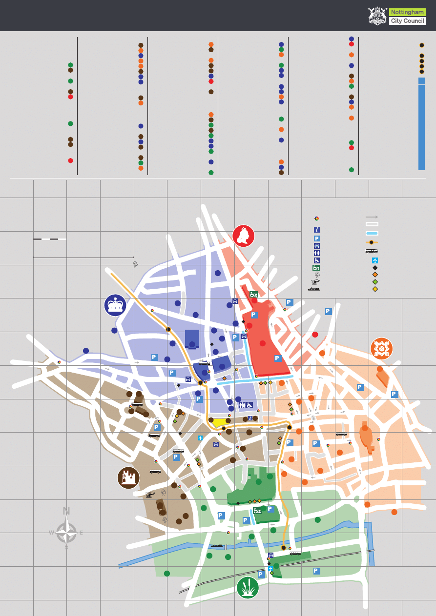
Key
Nottingham Navigator
Information Point
Nottingham Tourism
Centre
Car parking
Taxi ranks
Toilets
Disabled toilets
Shopmobility
Open space
Heli-pad
Moorings
One way streets
Pedestrianised
Restricted vehicle
access
Tram route and stops
Coach drop
off points
SkyLink bus
UniLink 4 bus
UniLink 34 bus
Park & Ride Link 1 bus
Park & Ride Link 2 bus
Safer, cleaner, ambitious
Nottingham
A city we’re all proud of
Victoria
zone
Lace
Market
zone
Royal
zone
Castle
zone
Broadmarsh zone
0
It will take approximately 5 minutes to walk this far
100
50
metres
Scale:
Walking distance:
This map is reproduced from
Ordnance Survey material
with the permission of
Ordnance Survey on behalf of
the Controller of Her Majesty’s
Stationery Office © Crown copyright.
Unauthorised reproduction
infringes Crown copyright and
may lead to prosecution or
civil proceedings. 100019317 2009.
Where do I find?
Welcome to Nottingham
Information points
Broadmarsh Shopping
Centre
(J7)
1
NCT Travel Centre
(H6)
2
Nottingham Railway
Station
(L8)
3
Nottingham Tourism
Centre
(H7)
4
Victoria Centre
(F7)
5
Shopping
Bridlesmith Gate
(I7)
Broadmarsh Shopping
Centre
(J7)
1
Clumber Street
(G7)
Derby Road
(G2)
Exchange, The
(H7)
6
F H Mall
(H7)
7
Hockley
(H10)
Lister Gate
(J7)
Victoria Centre
(F7)
5
Friends Meeting House
(E3)
58
Islamic Centre
(F9)
59
Nottingham Buddhist
Centre
(H8)
60
St Andrew’s with
Castle Gate (URC)
(F5)
61
St Barnabas
RC Cathedral
(G3)
62
St Mary’s Church
(J9)
63
St Nicholas’ Church
(J6)
64
St Peter’s (& St James’)
Church
(I7)
65
Synagogue
(E5)
66
Unitarian Chapel
(I10)
67
William Booth
Memorial Hall
(F9)
68
Transport Points
Bus Stations
Broadmarsh
(K7)
69
Victoria
(E7)
70
Train Station
Nottingham Railway
Station
(L8)
3
NCCL Galleries
of Justice Museum
(J9)
24
Nottingham Castle
(K4)
25
Nottingham
Contemporary
(J8)
26
Old Market Square
(H6)
27
Robin Hood Statue
(J5)
28
Speakers’ Corner
(H6)
29
Victoria Clock Tower
(E7)
30
Ye Olde Trip to
Jerusalem
(K5)
31
Public offices, community
centres and facilities
BBC East Midlands
(K10)
32
Central Library
(H5)
33
Citizens Advice Bureau
(L7)
34
Council House
(H6)
35
Crown & County Courts (K8)
36
Fire Station
(E6)
37
Guildhall
(F6)
38
HMRC – Inland Revenue (M4)
39
International Community
Centre
(D6)
40
Job Centre
(Canal Street)
(K9)
41
Entertainment
Albert Hall
(G4)
8
Broadway Media Centre (G9)
9
Cornerhouse, The
(G6)
10
Lace Market Theatre
(I8)
11
Nottingham Arts Theatre (H8)
12
Nottingham Playhouse
(H4)
13
Rock City
(F4)
14
Royal Centre
(G6)
15
- Royal Concert Hall
- Theatre Royal
Sky Mirror
(H3)
16
Trent FM Arena
(H10)
17
Places of interest
and key attractions
Bonington Art Gallery
(E5)
18
Brewhouse Yard
Museum
(K5)
19
Brian Clough Statue
(H6)
20
Castle Gatehouse
(J5)
21
Castle Museum
and Art Gallery
(K4)
22
City of Caves
(J8)
23
National Ice Centre
(H10)
17
P
Tram Stops
Lace Market
(H8)
B
Nottingham
Trent University
(E5)
E
Old Market Square
(H6)
C
Royal Centre
(G5)
D
Station Street
(L8)
A
Car Parks
Arndale
(K6)
1
Broadmarsh
(K8)
2
Fletcher Gate
(I8)
3
Huntingdon Street
(E8)
4
Mount Street
(H4)
5
Nottingham Railway
Station
(M9)
6
Queen’s Bridge Road
(M7)
7
St James’s Street
(I5)
8
Stoney Street
(I9)
9
Talbot Street
(F4)
10
Trinity Square
(F7)
11
Upper Parliament Street (G5)
12
Victoria Centre North
(E7)
13
Victoria Centre South
(F8)
14
Wollaton Street
(G5)
15
Job Centre
(Parliament Street)
(G5)
42
Magistrates’ Court
(L6)
43
NHS Walk in Centre
(K11)
44
Nottinghamshire
Archives
(L6)
45
Police
(F6)
46
Post Office
(G6)
47
Public Toilets
(Greyhound Street)
(H7)
48
Trading Standards
(E6)
49
Victoria Leisure Centre (G11)
50
YMCA
(E7)
51
Centres of Learning
Castle College
(K6)
52
New College
Nottingham
(H9)
53
The Nottingham
Trent University
(F5)
54
Places of worship
Central Methodist
Mission
(G8)
55
Christian Centre
(F2)
56
Congregational Church
(I6)
57
As part of the ParkSmart scheme, Nottingham city centre has been divided into five zones. Below you
will find a brief guide to the key attractions and places of interest in each.
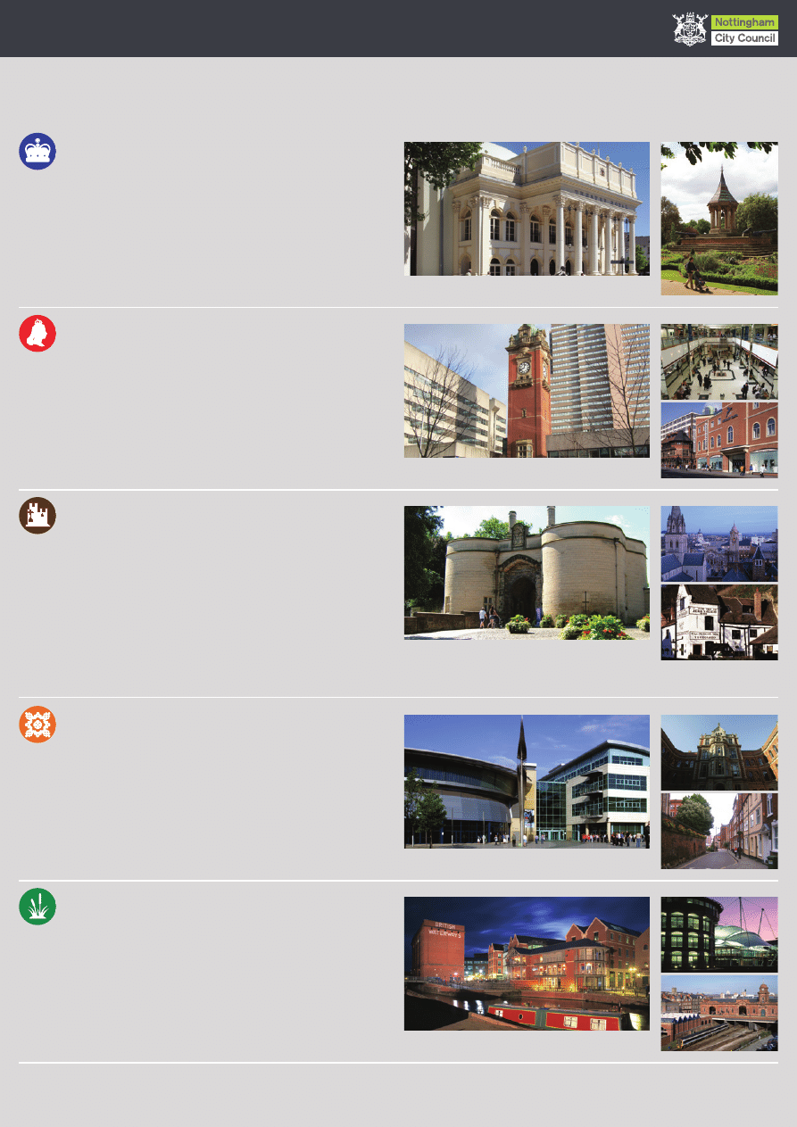
Above, Theatre Royal. Right, The Arboretum.
Above, Victoria Clock Tower. Right, Victoria Centre.
Above, Castle Gatehouse. Right, View over St Barnabas to the
city centre. Below right, Ye Olde Trip to Jerusalem Inn.
Nottingham Navigator has been jointly funded by Nottingham City Council, Greater Nottingham Partnership and East Midlands Development Agency.
Nottingham City Council gratefully acknowledges the contributions from many organisations and individuals in the making of these panels.
Nottingham Navigator was designed by Streetwise Orientation & Navigation Systems, www.streetwisesystems.com
At the heart of this zone is the Royal Centre, comprising the splendid
Theatre Royal which dates back to 1865, alongside the more modern
Royal Concert Hall. Nearby are The Cornerhouse and Trinity Square
developments offering a variety of leisure venues including a multi-screen
cinema, bars and restaurants.
There is a wide range of shopping, wining and dining throughout the area
which also plays host to two of Nottingham’s major centres of learning,
Nottingham Trent University and Nottingham High School.
Royal zone
Shopping dominates this zone which was once home to the city’s Great
Central and Great Northern railway lines. The Clock Tower of the former
Victoria Railway Station was preserved and now marks one of the
entrances to the modern day Victoria Centre.
Next to the shopping centre is the original Victoria Hotel which
accompanied the former station.
Victoria zone
Within the impressive walls that once surrounded the original medieval
Nottingham Castle is a magnificent 17th century ducal mansion with
wonderful views over the Castle zone and the entire city centre.
The iconic statue of Robin Hood stands outside the Castle walls just downhill
from the Castle’s 13th century Gatehouse. There is also much to see and do
at the Nottingham Castle Museum & Art Gallery inside the Castle.
Many other historic buildings and fine architecture can also be found in the
area, particularly along Castle Gate and in the Old Market Square, and there
is a wide selection of wining, dining and leisure venues nearby.
Castle zone
Now part of Nottingham’s proud heritage, the Lace Market was at the
forefront of UK lace design and manufacturing throughout the 18th century
when there were more than 130 lace factories in this area of the city.
Today the magnificent lace and textile factories have been converted into
specialist shops, restaurants, cafés and bars, offices, apartments and the
city campus of New College Nottingham.
The award winning NCCL Galleries of Justice Museum, Nottingham
Contemporary art gallery and the National Ice Centre are also in this area.
Lace Market zone
The Broadmarsh zone is the gateway to the city centre for many visitors
to Nottingham, with Nottingham Midland Station and Broadmarsh Bus
Station situated here. There are lots of places to shop in this zone,
particularly in the Broadmarsh Shopping Centre, entered from Collin
Street, Lister Gate and Middle Pavement.
As well as taking advantage of the excellent shopping, enjoy a stroll
along the canal at Castle Wharf and relax at one of the many waterside
bars and restaurants.
Broadmarsh zone
Welcome to Nottingham • zone guide
Above, Castle Wharf. Right, Inland Revenue.
Below right, Nottingham Railway Station.
Above, National Ice Centre. Right, Adams Building.
Below right, High Pavement.
Wyszukiwarka
Podobne podstrony:
Tirana City Centre Map
Brighton city centre walking map 2012
Peterborough city centre
Under the city centre, the ancient harbour Tyre and Sidon heritages to preserve
RETAIL REVIT SMALL CITY CENTRES
Peterborough city centre
Brutal New Zella City Map
Castles & Crusades Ilshara City of Jendar Map
Mutants & Masterminds Freedom City Map
Map of the Mexico City Metrobus
więcej podobnych podstron