
Section 5
L3164PC
Temporal Processing of
Millimeter Wave Flight Test Data
May 2006
Benjamin Montalvo, Tony Nguyen, Tony Platt, Michael Franklin, Karsten Isaacson,
Henry Tzeng, Ray Heimbach, Alan Roll, Don Brown, William Chen
BAE Systems
Electronics & Integrated Solutions
5140 West Goldleaf Circle
Los Angeles, CA 90056-1268
ABSTRACT
This paper describes work that was done to improve millimeter-wave radar image by
utilizing temporal processing on radar data collected during a recent flight test program
on the NASA AIRES aircraft.
These flight tests were part of the Follow-On Radar, Enhanced and Synthetic Vision
Integrated Technology Evaluation (FORESITE) project under the NASA Aviation Safety
and Security Program (AvSSP) Synthetic Vision Systems (SVS) program.
Analog radar IF signals were digitized and the digital data output was recorded during the
flight tests. The digital data was replayed after the flight tests and a number of samples
were post processed using a temporal processing algorithm with the intention of
evaluating this temporal algorithm and assessing the computational requirement. The
images enhanced by temporal processing exhibit a significant improvement in image
quality.
Proprietary Information
The information contained herein is proprietary to BAE Systems and shall not be
reproduced or disclosed in whole or in part or used for any design or manufacture
except when such user possesses direct written authorization from BAE Systems
Distribution Statement C
Distribution authorized to U.S. Government agencies and their
contractors. Other requests for this document shall be referred
to BAE Systems.
Note
This information is not Technical Data per 22 CFR 120.10(1)
and can be exported without license in accordance with
22 CFR 120.10(5).

1.0 INTRODUCTION
A flight test program was conducted during August and September of 2005 on the NASA ARIES test
aircraft, a Boeing 757-200 (Figure 1) based at NASA’s Langley Research Center. The flight test area
concentrated on the Wallops Island airfield off the northeast Virginia coast. Eight evaluation flights were
made, including two night flights, in addition to seven demonstration flights (including one practice demo
flight) for a total of 15 flights. The system under test fused imagery from a 94 GHz imaging radar with
the output from two Infrared cameras and displayed the resulting image on a Head Up Display (HUD).
During tests, a number of low level approaches were performed where an obstacle (a truck) was
deliberately placed at the end of the runway to determine whether the pilot would spot the return from the
object in the fused radar/IR image on the HUD, with the objective of providing an intuitive visual
incursion warning capability. During the test program, the raw radar data was recorded for future analysis
and the evaluation of new processing techniques, including temporal processing.
Figure 1. BAE Systems 94 GHz Radar Systems Flight Test – the NASA 757-200
L3164PC
2

2.0 TEST
SYSTEM
DESCRIPTION
Figure 2 is a simplified representation of the system architecture. The 94-GHz imaging radar was
mounted in the nose radome. The Infrared sensors were mounted in a fairing on the underside of the
aircraft. Output signals from the Infrared sensors were processed though a computer and sent to the
Enhanced Synthetic Image Processor (ESIP). The ESIP provided radar processing which produced a
C Scope millimeter wave image. The millimeter wave image and an infrared sensor images were then
fused, mapped, and warped together in the Image Processor Module located inside the ESIP and sent to
the Head Up Display (HUD) in the cockpit for presentation to the pilot. The ESIP communicates with an
External Control Computer via bi-directional RS-422 communication links.
Senor :
94 Ghz
Millimeter
Wave Radar
Sensor :
Long Wave
IR Camera
Sensor :
Sort Wave IR
Camera
Radar Processor
Image Processing Card:
Fusion
Blending
Crystal PC
DVI to
VGA
Convertor
VGA to
RS-343
SVS Sensor
Computer
Pow er / Monitor
HUD
HGS-4000
Disk Array Storage
RAID
ESIP
analogIF
analog/discrete control
ON/OFF discrete
LPSD analog
RS-170
analog
analog
RS-170
DVI
VGA
RS-343
optical
Ethernet
RS-422
optical
WOW
GPS time
ARINC 429
Figure 2. Enhanced Vision System of NASA Aries B-757 Architecture
Real time image processing was performed within the ESIP to provide imagery for the HUD. An
example of the 94 GHz radar, real time image produced without temporal processing, is shown in
Figure 3. The Radar’s analog (base band) IF signals were digitized and recorded on a Disk Array during
the flight for the post flight temporal processing investigation.
L3164PC
3

Figure 3. 94 GHz radar real time runway image
without temporal processing during the flight test – August 2005
3.0 THE TEMPORAL PROCESSING OF FLIGHT TEST DATA
3.1 Coordinate Definition
Consider the forward looking radar installed in the aircraft nose, as shown in Figure 4.
Radar Ref Frame
Ground Plane
Max Range
Nadir
A
B
C
R
Footprint
of Main
Beam
X
Y
Z
Figure 4. Imaging scene of millimeter wave radar
L3164PC
4

The coordinate systems are defined as follows.
a.
(A) World Earth Centered, Earth Fixed (ECEF) frame. XY plane is the Equator
plane with X axis crossing Prime Meridian. Z axis points to North Pole.
b.
Navigational North East Down (NED) frame. X axis points to North, Y axis
points to East, and Z axis points down. Centered with the aircraft center of
mass.
The Earth Centered, Earth Fixed (ECEF) frame and North East Down (NED) frame is shown at
Figure 5.
c.
Aircraft Body (Body) frame. X axis point forward out of the nose of the aircraft,
Y axis points to the right (out of the right wing tip), and Z axis point down (out
of the belly of the aircraft). Centered with the aircraft center of mass.
d.
Local Level (Level) body frame. Coincidental with the aircraft body frame and
Z axis aligned with the gravity vector.
Z
Y
X
Prime
Meridian
Equator
X
NED
Y
NED
Z
NED
Figure 5. Earth Centered, Earth Fixed (ECEF) frame in red color and North East Down
(NED) frame in blue color
L3164PC
5

X
Y
Z
Figure 6. Aircraft Body Frame and Local Body Frame
e.
Radar Installation (Radar) frame. Fixed with respect to the aircraft body frame
with its origin at the radar servo swivel point. Relation between the aircraft body
frame and radar installation frame is characterized by translation and rotation.
f.
Radar Image (Image) frame. Coincidental with the radar installation frame when
the radar antenna is pointing at zero degrees in elevation. This frame rotates
with the antenna in elevation. The Y axis is identical to the radar installation
frame. Mechanical azimuth rotations of the antenna are performed about Z axis
of this frame.
3.2 Algorithm Description
3.2.1 Unit Vector Definition
Consider normal vector to the Local Level (and ground) plane
⎥
⎥
⎥
⎦
⎤
⎢
⎢
⎢
⎣
⎡
=
1
0
0
Level
n
Transform this normal vector of Local Level frame to the Radar Image frame
:
=
age
n
Im
Transform Level frame to Radar Image frame
(
)
)
(
),
(
),
(
,
elevation
e
roll
r
pitch
p
n
Level
Define the Local Level frame origin as:
)
0
,
0
,
0
(
=
Level
LevelOrg
P
Transform the Local level frame origin point to a point in the Image frame
Transform Level to Image
(
)
=
age
LevelOrg
P
Im
)
(
),
(
),
(
,
elevation
e
roll
r
pitch
p
P
Level
LevelOrg
The normalized unit vector is written as:
)
(
Im
Im
Im
age
LevelOrg
age
age
P
n
Normalize
n
−
=
L3164PC
6

3.2.2 Point to Point Distance
The distance from radar Image frame original to the point at ground plane is calculated as
u
age
initial
z
n
height
d
•
=
Im
Where
is unit z vector in the Image frame.
⎥
⎥
⎥
⎦
⎤
⎢
⎢
⎢
⎣
⎡
=
1
0
0
u
z
•
- dot product operator.
The point
at Image frame is
n
P
initial
age
n
d
n
P
⋅
=
Im
Assume the radar scan at selected nine azimuth angle, i.e. the azimuth values shift nine times, the
shift value is account for the incremental computation from point one to point nine.
In order to calculate the distance from the point at Image frame to the point perpendicular to earth
surface, let’s define the vectors
⎥
⎥
⎥
⎦
⎤
⎢
⎢
⎢
⎣
⎡
⊗
⎥
⎥
⎥
⎦
⎤
⎢
⎢
⎢
⎣
⎡
+
+
=
1
0
0
0
)
sin(
)
cos(
azshift
h
azimut
azshift
h
azimut
r
i
i
Where azimuth
i
= initial azimuth angle. azshift = incremental azimuth angle
⊗
is a cross product operator.
And
)
(
Im
r
n
Normalize
q
age
⊗
=
The perpendicular distance from Image frame origin point to the point of earth surface is
n
perpend
P
q
d
⊗
=
The distance from imaging point
to the point perpendicular to earth surface
n
P
perpend
P
2
2
1
_
perpend
perpend
pn
d
d
d
−
=
if
ε
>
−
perpend
d
d
1
, where
ε
=0.0001
= 0 otherwise
T
he distance from the points
and instantaneous maximum imaging point
is:
perpend
P
.
max
tan t
ins
P
2
2
max
tan
_
.
perpend
t
ins
perpend
d
MaxRange
INST
d
−
=
L3164PC
7

And distance between the initial image points
and instantaneous maximum imaging point
can be written as
n
P
max
tan t
ins
P
(if the antenna depression angle is negative)
(
otherwise)
max
tan
_
_
max
tan
_
t
ins
perpend
perpend
pn
t
ins
pn
d
d
d
+
=
max
tan
_
_
t
ins
perpend
perpend
pn
d
d
−
=
The fundamental point to point relationship is shown at Figure 7 below.
Radar Image Frame
Ground Plane
A
B
d
perpend
R
X
Y
Z
P
n
d
initial
Instantaneous
max. imaging line
Instantaneous
slant range
Figure 7. Point-to-Point Distance Relationship
3.2.3 Range Compensation and Texture (Image) Construction
If we walk the line from
to
step by step, the incremental step distance is defined as
n
P
.
max
tan t
ins
P
Rangebin
d
d
t
ins
pn
max
tan
_
=
∆
Where “Rangebin” is the number of range bins assumed at the processing stage.
Range compensation is performed at each
2
d
∆
point for display gain adjustment.
A compensation look up table is pre-established from an empirical result. The first compensation
point is expressed as
L3164PC
8

)
2
(
1
_
d
q
P
P
n
tion
stcompensa
n
∆
⋅
+
=
Each range profile has its own gain value after range compensation at each point. It is written as
)
1
,
(
1
_
0
,
1
−
=
−
i
P
e
LookupRang
le
Rangeprofi
tion
stcompensa
n
i
Range profile gain value is interpolated between the values of the two neighboring profile bins if
the
(is not an integer)
ution
rangeresol
P
tion
stcompensa
n
/
1
_
Based at our azimuth scan angle, from – xy degrees to + xy degrees, we construct the N images
which is equal to the ramp duration of transmitting wave. The formation of the ground patch for
image rending is shown in Figure 8.
The return data in the imaging frame is transformed from image frame coordinates to the Local
Level, NED and ECEF frames. Each ground patch layer represents one radar scan cycle.
During each rendering cycle, the pilot’s current design eye position is used as the viewing
position for rendering, and the orientation of the viewport is adjusted to match the aircraft
attitude. The previously processed ground referenced textures are then rendered onto a ground
plane positioned at the airfield altitude.
Multiple textures are available for each ground location and these are blended together during the
rendering process to reduce the noise in the images presented to the pilot.
The rendering process is shown in Figure 9.
L3164PC
9
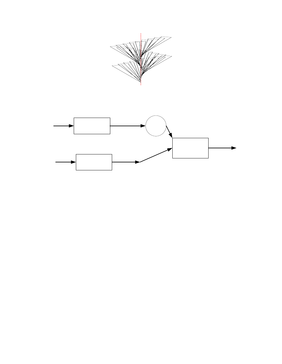
Figure 8. Ground patch construction for image rendering
Fast
Process
Radar input
Texture at ECEF
Coord.
Transform
Camera position
Nav. Data
Graphic
Generation
Frame
Buffer
Rendering
N layer blending
Video output
Figure 9. Video process of N layers image rendering
L3164PC
10
3.3 Processing Results
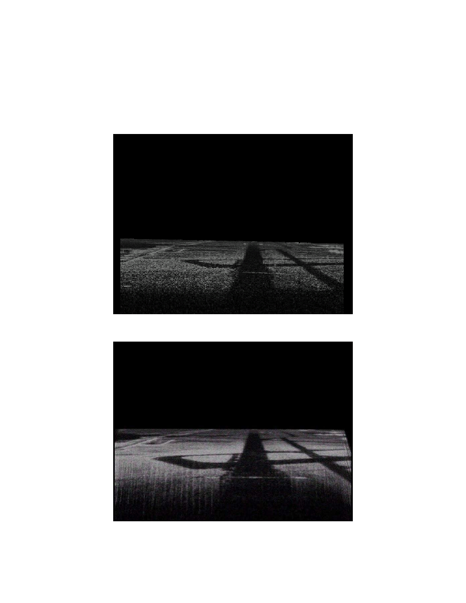
The flight test data was processed off line using the algorithm described above. The resulting
images show that the temporal processing has reduced the image noise and improved the runway
image. Figure 10A and Figure 10B show a comparison in performance between unprocessed and
processed images for the same view of a runway from an approaching aircraft.
Figure 10A. Unprocessed Radar Image
Figure 10B. Temporally Processed Radar Image
L3164PC
11
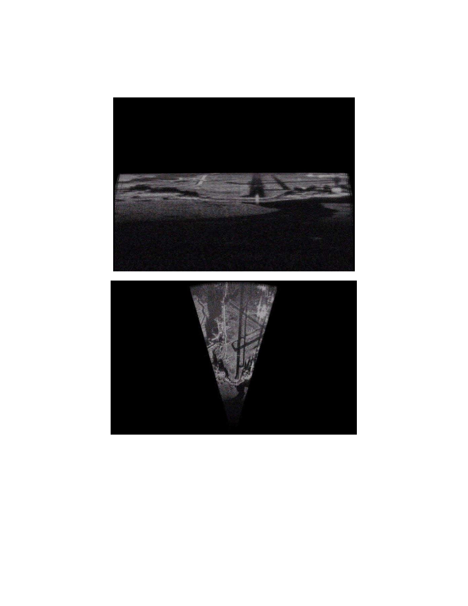
Figure 11 through Figure 15 are a series of pictures which show the images generated as the
aircraft overflies the runway, and are displayed as C-scope projections and a corresponding
bird’s-eye view image
Figure 11. Runway image on approach after temporal processing
L3164PC
12
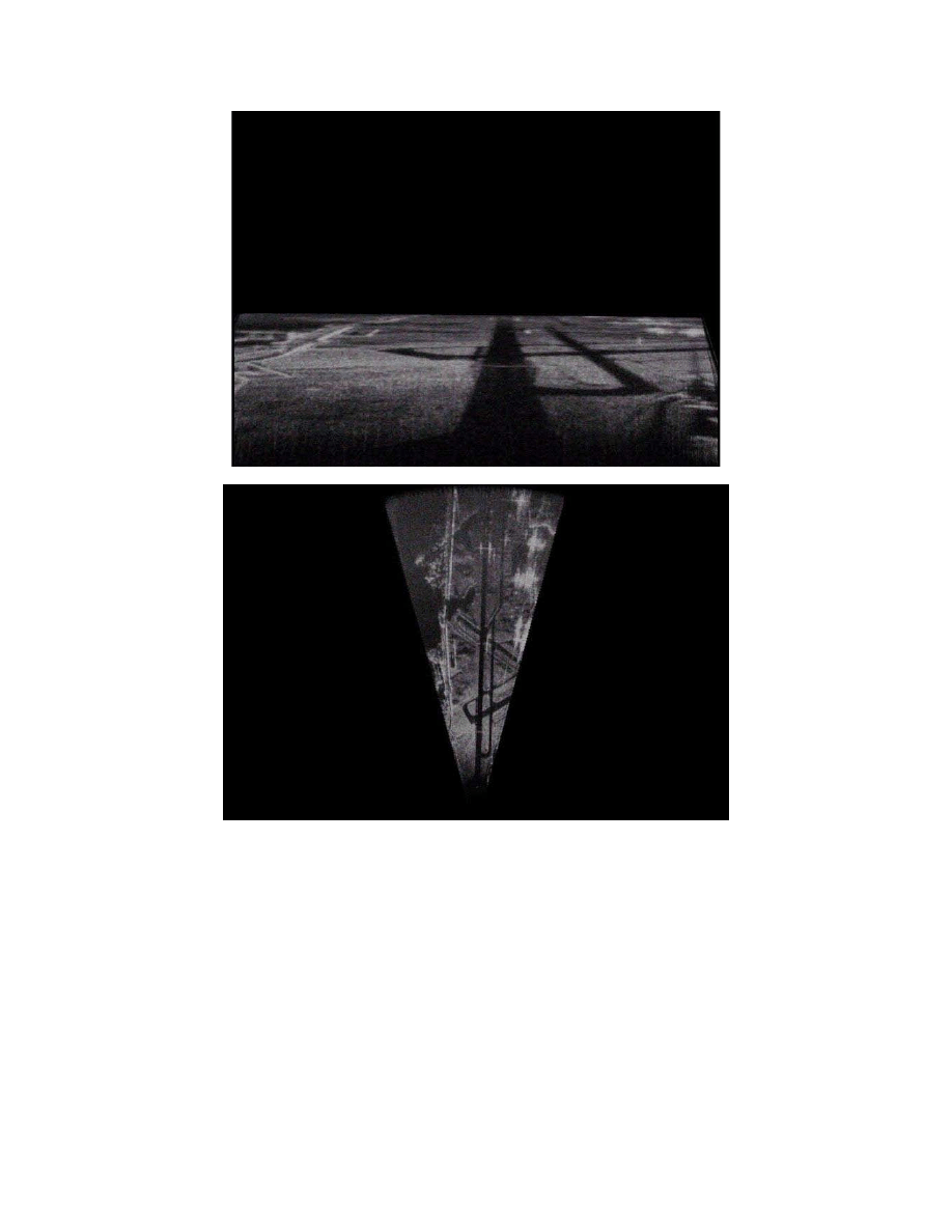
Figure 12. Runway image on approach after temporal processing
L3164PC
13
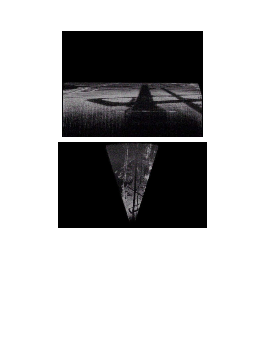
Figure 13. Runway image on approach after temporal processing
L3164PC
14
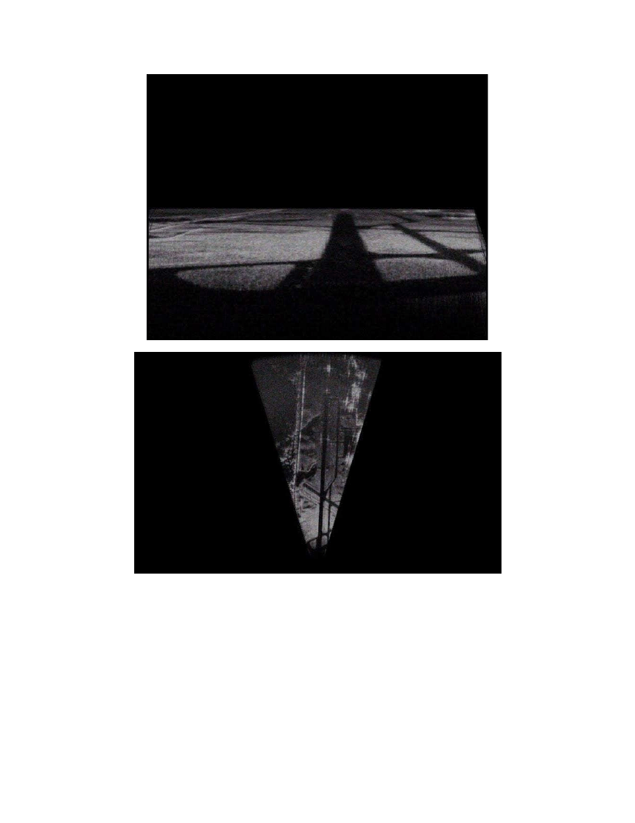
Figure 14. Runway image on approach after temporal processing
L3164PC
15
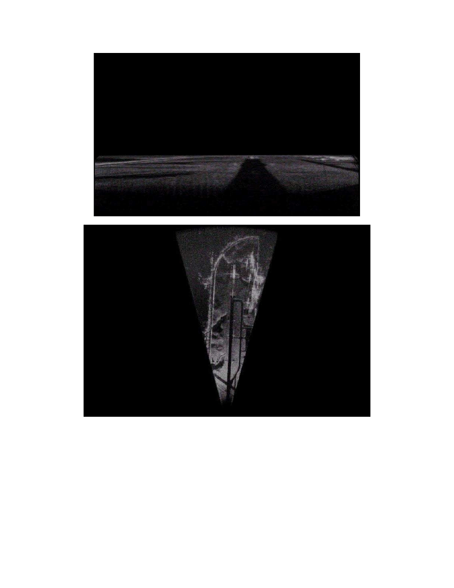
Figure 15. Runway image on approach after temporal processing
L3164PC
16
Document Outline
Wyszukiwarka
Podobne podstrony:
us convoy sop 2006
us dhs hamas 2006
us f35 baranowski 2006
[US 2006] D517986 Wind turbine and rotor blade of a wind turbine
us georgia 295m grant 2006
us provance 2006
transac US Jap1960 2006
us jpm bds opsec 2006
[US 2006] D517986 Wind turbine and rotor blade of a wind turbine
us secdef ied media policy 2006
US ARMY medical course Pharmacology IV (2006) MD0807
US Army medical course Chemical, Biological, Radiological, Nuclear, Explosive (2006) MD0534
transac US Jap1960 2006
puchar swiata 2006 www prezentacje org
Gospodarka płynami kwiecień 2006
Znaki taktyczne i szkice obrona, natarcie,marsz maj 2006
więcej podobnych podstron