
Landscape
Transformations and
the Archaeology
of Impact
Social Disruption and State
Formation in Southern Africa

CONTRIBUTIONS TO GLOBAL HISTORICAL ARCHAEOLOGY
Series Editor:
Charles E. Orser, Jr., Illinois State University, Normal, Illinois
A HISTORICAL ARCHAEOLOGY OF THE MODERN WORLD
Charles E. Orser, Jr.
AN ARCHAEOLOGY OF MANNERS: The Polite World of the Merchant
Lorinda B. R. Goodwin
AN ARCHAEOLOGY OF SOCIAL SPACE: Analyzing Coffee Plantations
James A. Delle
BETWEEN ARTIFACTS AND TEXTS: Historical Archaeology in Global
Perspective
Anders Andrén
DOMESTIC ARCHITECTURE AND POWER: The Historical Archaeology
Ross W. Jamieson
HISTORICAL ARCHAEOLOGIES OF CAPITALISM
Edited by Mark P. Leone and Parker B. Potter, Jr.
THE HISTORICAL ARCHAEOLOGY OF BUENOS AIRES: A City
Daniel Schávelzon
LANDSCAPE TRANSFORMATIONS AND THE ARCHAEOLOGY OF
IMPACT Social Disruption and State Formation in Southern Africa
Warren R. Perry
MEANING AND IDEOLOGY IN HISTORICAL ARCHAEOLOGY Style,
Heather Burke
RACE AND AFFLUENCE: An Archaeology of African America and
Paul R. Mullins
Elite of Colonial Massachusetts
in Jamaica's Blue Mountains
of Colonial Ecuador
at the End of the World
Social Identity, and Capitalism in an Australian Town
Consumer Culture
A Continuation Order Plan is available for this series. A continuation order will bring
delivery of each new volume immediately upon publication. Volumes are billed only upon
actual shipment. For further information please contact the publisher.

Landscape
Transformations and
the Archaeology
of Impact
Social Disruption and State
Formation in Southern Africa
Warren R. Perry
Central Connecticut State University
New Britain, Connecticut
New York, Boston, Dordrecht, London, Moscow
Kluwer Academic Publishers

eBook ISBN:
0-306-47156-6
Print ISBN:
0-306-45955-8
©2002 Kluwer Academic Publishers
New York, Boston, Dordrecht, London, Moscow
All rights reserved
No part of this eBook may be reproduced or transmitted in any form or by any means, electronic,
mechanical, recording, or otherwise, without written consent from the Publisher
Created in the United States of America
Visit Kluwer Online at:
http://www.kluweronline.com
and Kluwer's eBookstore at:
http://www.ebooks.kluweronline.com

Foreword
Landscape, settlement, spatial, and the material consequences of
human behavior have posed challenges to many archaeologists, espe-
cially when it comes to explaining the means by which human soci-
eties have encountered different phenomena, as well as the various
coping strategies they have developed as they face the reality of the
environment. Human uses of the landscape reflect, in varying de-
grees, the interrelationship established among human factors such
as history, social structure, and physical space. However, owing to
changes in the size, composition, and needs of social groups, as well as
the increased development of survival strategies, the patterns of
behavior generated are eventually transformed. But clearly explain-
ing the process of the transformations requires a reconstruction of
the frequency with which material manifestations of related human
behaviors are bonded together, by use and the testing of relevant and
applicable models. Sorting out and aligning the complex data about
the interconnections and associations make it more challenging and
sometimes even exciting. Only a well-thought-out research approach,
such as adopted in this book, can effectively stand up to the test that
many archaeologists have to face. Aware of this basic problem, Warren
Perry clears the way by outlining the basic assumptions of his study
and dissociating himself from the erroneous assumptions often made,
which create the impression that societies they identify had concepts
of social and spatial patterns equivalent to those of the social scientist
or of the ethnoarchaeologist. Areal variations of the relationships
among cultural phenomena are so numerous that archaeologists
have, over the centuries, looked for regularities or patterning of
distribution of their manifestations, the basic assumption being that
patterns consist of recurring modes of human activities or behavior.
This book goes beyond mere pattern recognition and explores factors
such as cosmology; traditional views of spatial organization and
social networks; exploration of the landscape; concepts of boundaries,
territoriality, land tenure; and perception of the natural environment
in the folk traditions about ecology and attitudes toward natural
V

vi
Foreword
resources as the major factors that contribute to landscape trans-
formations. An observed major achievement of the study is the dem-
onstrated rejection of concepts and models that have continued to
perpetuate colonial research mentality that shield away objective
explanations in African history and culture. The doom of the “Settler
Model,” the most persistent in the history and culture of southern
Africa having been now dispelled, will undoubtedly open a new chap-
ter in methodological approaches toward the reconstruction of the
history of small-scale groups such as this book examines. It will also
confirm the call to historical archaeologists to challenge historio-
graphic concepts and themes that have derailed our understanding of
the actual processes of the formation and transformation of African
societies.
One of the lessons that has come out of my own research on the
early settlements and spatial behavior of societies in the Volta Basin
of Ghana is the significance of the data on the patterns of social
behavior to which individuals and groups conform in their dealings
with one another. Like the findings of Perry’s research, the data
demonstrate that objects or artifacts of archaeological significance
should be considered as behaving within certain local rules of the
society, because they were the products of their past human social
behavior. Therefore, the study of artifacts is the study of human
behavior (social, economic, and the like) that produced them. At the
same time, it has been recognized that the sociospatial consequences
of human behavior vary according to the level of human settlement at
the macro or micro level, as Perry ably demonstrates. This is illustra-
tive of what I have referred to as the local rule (LR) model of spatial
behavior and, like Perry’s approach, examines a social system as the
dynamic factor that creates its own repetitive patterns that accom-
modate transformations in the landscape while creating the bulk of
the material evidence of human spatial behavior at archaeological
sites. Some scholars have attempted to demonstrate this situation by
use of summary mathematical rules that govern such social relations
between individuals or groups and their landscapes. Perry‘s statistics
and histograms on transformations in settlement size and hierarchy,
population movements before and after the occupation of Mfecane/
Difaqane sites in the various regions, confirm that such summary
mathematical or statistical rules will continue to constitute effective
ways of differentiating evidence of “local rules” of social differentia-
tion specific to a society or societies and the landscape that played a
role in their transformation. But because of the impossibility of ob-

Foreword
vii
serving the socialbehavior of past societies, we have to rely on models
drawn on modern social behavior patterns of behavior formulated in
rules which, in modern societies, are recognized as rules of etiquette
or moral rules. The rules must combine both spatial and social factors
in one package.
All these lead to a single conclusion, which is clear from this book:
that spatial behavior cannot be understood apart from its social con-
text; that geographical space constitutes a reflection of social mean-
ings about how the space is used. It is also obvious from Perry’s
analysis that the Settler Model does not take into consideration the
fact that it was applied to traditional societies who do not consider
landscape as a commodity that can be cut into pieces and sold as
parcels. As the book demonstrates, for these groups, land is seen in
terms of social relationships, and, although these relationships may
change over time in any given situation, the structural and other
cultural features such as houses, storage facilities, burial grounds,
and other fixed structures become marks that remain in the archaeo-
logical record.
Another major achievement of this book is Perry’s ability in
creating the connection of the simultaneous cultural research into
archaeology, ethnology, and ethnohistory in one package and in ways
that lead him to new and refreshing interpretations and perspectives
on the history and culture of southern African societies, consequently
giving a final devastating blow to the Settler Model that is likely to
disappear with the passing century that nurtured it. Happening
through Perry’s hands, one of the few African American Africanist
archaeologists, one can forsee how the new dimension of this study
will benefit archaeological research on both sides of the Atlantic. With
very few exceptions, overall theoretical perspectives of interactive
nature are few and far between in the historical archaeology of
Southern Africa. In spite of the advisability of keeping the boundaries
of the study of spatial behavior open-ended, there is a growing need
for some type of theoretical and methodological integration and or-
ganized framework. Landscape Transformations provides an exam-
ple in this direction and should lead the way into the historical
archaeology of the region in the new millennium. The book challenges
the historiographic concepts that relegate the achievements of South
African societies to a secondary place in human history and also calls
on researchers to redress the imbalance in contemporary scholarship
about the period of colonization, drawing on certain dimensions that
continue to remain concealed from human knowledge. It is difficult

viii
Foreword
for an archaeologist to escape the constraints of available sources or,
indeed, can the pitfalls of preconceived ideas of the collective sub-
conscious or the prevailing ideology of a particular culture or civiliza-
tion be avoided. But one clear thing about this book is that it calls for
research that goes beyond common approaches to the study of human
societies as victims of slavery, deprivation, and degradation, and
should certainly help explain the formation and transformation of
those processes and how those societies defined their landscape,
power relations, justice, and their local traditional values as well
as individual and group achievements or contributions to human
history.
E. K
O
FI
A
G
O
RSAH
Chair
Department of Black Studies
Portland State University
Portland, Oregon

Preface
One of the most exciting archaeologies on the planet is the archaeol-
ogy of southern Africa. In part this is related to recent political
developments as well as to the current development of historical
archaeology in southern Africa. When European political economy
came into contact with indigenous people, social relations changed
both locally and globally. This is the central problem in the histori-
ography and historical archaeology of the area. I got myself involved
in this research by going to Swaziland, southern Africa, to do archae-
ological research on the emergence of the Swazi state in 1984. My
research project concentrated on the unsanctioned realms of the re-
cent history of present Swazi state formation-the Mfecane/Difaqane
period. My interest in the Mfecane/Difaqane began to take shape
while doing archival and historical research there. When I consulted
the Swaziland archival materials, especially the testimony repro-
duced in the British Parliamentary Papers or “Blue Books,” I found
them incomplete. I began to wonder what the particulars were on
white involvement in the international trade, especially whether
slave trading had a significant impact on the Mfecane/Difaqane.
What became clear to me was that there remained a forgotten ele-
ment in all this research: the role of white involvement in racial
commodity slavery and its impact on the Mfecane/Difaqane. Further-
more, perhaps for political and ideological reasons, it became glaringly
apparent that there had been no archaeological investigation of the
Mfecane/Difaqane—and this became my task.
My Swaziland archaeological field research, itself shaped by the
legacy of African-American struggles in my own historical experi-
ence, made me acutely aware of the complexities of life in apartheid
southern Africa by revealing and illuminating the contemporary
social forces that are in contention over the interpretation and owner-
ship of Swazi history. My research involved both dialogue and practi-
cal activity with a myriad of people intricately divided into a variety
of social positions, which emerge in a particular historical context. It
enmeshed each participant in the power relations of contemporary
ix

x
Preface
Swaziland and their place in the global system of European-North
American domination.
I quickly discovered that (1) all historic archaeological research is
political, and extends beyond artifacts and settlements, and is linked
to historical context and anthropological knowledge production; po-
litical activity involves coercion but also entails everyday forms of
resistance and negotiation of how the past and the present are under-
stood and categorized; and (2) a more inclusive understanding of
power includes an ability to contest constraints and reject accounts
imposed by others while creating alternative accounts that are mean-
ingful is at the core of self-identity in social relations of domination
and resistance.
Descriptions of the Mfecane/Difaqane began to appear in early
travelers’ accounts and became embedded into Afrikaner and British
folklore, and they have continued over the years in countless new
books and articles recounting and reifying this tumultuous event. I
therefore refer to this version of the Mfecane/Difaqane as the Settler
Model. The Settler Model argues that the military Zulu state emerged
from the need to control the most productive agricultural and grazing
lands in the area of what is today the Natal province. Explanations
for Zulu state formation focused on increasing conflictual relations
between traditional African rivalries arising from localized demo-
graphic stress and ecological deterioration. Others who recognized
European involvement emphasized competitive trade relations be-
tween African polities for control of ivory and cattle exports at De-
lagoa Bay The idea of an internal, Zulucentric Mfecane/Difaqane
divorced from the trade in African captives remains unchallenged.
Furthermore, the Zulu and (specifically) Shaka were portrayed as
bloodthirsty antagonists-provocateurs who ruled over neighboring
African people by terror and fear. Finally, the Settler Model alleges
that it was the European colonists who brought peace and stability to
southern African peoples by eventually defeating the Zulu during the
late nineteenth and early twentieth centuries. My archaeological
analyses have demonstrated that the Mfecane/Difaqane as described
in the Settler Model is incorrect and therefore must be rejected.
This book is an attempt to use archaeological materials to inves-
tigate the validity of the Settler Model and Mfecane/Difaqane theory.
I also hope to show the usefulness of archaeology in bypassing the
biases of the ethnohistorical and documentary records and thereby
generating a more comprehensive understanding of history.

Preface
xi
This book is dedicated to the members of my doctoral disserta-
tion committee: Gregory Johnson, James Moore, Robert Paynter, and
Paul Welch. Their critical insights, comments, and painstaking ef-
forts on my behalf are deeply appreciated. Special thanks to Carol
Kramer whose early guidance and contributions as mentor will never
be forgotten. Thanks also to Charles Orser and Eliot Werner at
Plenum Press who felt my work worthy of publication. This book was
written for all the people of southern Africa who have dedicated
themselves, many with their lives, to the liberation of African people
in Africa and throughout the diaspora. In Africa I owe my greatest
debt to Musi Khumalo and Dumsani Sithebe, who befriended me
and taught me about Africa and who shared their cultural expertise
with me. Finally, many thanks to my family, especially my wife
Carmen, my sons Ronald, Bruce, and especially my youngest son
Warren Albizu, without whose love this book could never have been
completed.

This page intentionally left blank.

Contents
C
HAPTER
1. Southern
Africa
and
the
Archaeology
of Impact . . . . . . . . . . . . . . . . . . . . . . . . . . . . . . . . . . . . . . . . . . .
1
Introduction: The Research Question . . . . . . . . . . . . . . . . . . .
1
The Settler Model and Its Problems . . . . . . . . . . . . . . . . . . . .
1
Middle-Range Theory: Archaeological Data and
the Documentary Record . . . . . . . . . . . . . . . . . . . . . . . . . . . . .
3
C
HAPTER
2.
The Mfecane/Difaqane Problem from
the Documentary Record . . . . . . . . . . . . . . . . . . . . . . . . . . . . .
9
Demographic Emphasis . . . . . . . . . . . . . . . . . . . . . . . . . . . . . . . . 10
Ecological Emphasis . . . . . . . . . . . . . . . . . . . . . . . . . . . . . . . . . . . 11
Vindicationist Arguments . . . . . . . . . . . . . . . . . . . . . . . . . . . . . . 13
External Trade . . . . . . . . . . . . . . . . . . . . . . . . . . . . . . . . . . . . . . . . 14
Cobbing's Reanalysis . . . . . . . . . . . . . . . . . . . . . . . . . . . . . . . . . . 17
Summary . . . . . . . . . . . . . . . . . . . . . . . . . . . . . . . . . . . . . . . . . . . . . 20
The Standard Story of the Mfecane/Difaqane . . . . . . . . . . . .
9
C
HAPTER
3. Archaeological
Correlates
of
the
Settler
Model 21
Ethnographic and Ethnohistorical Descriptions . . . . . . . . . . 21
Pre-Mfecane/Difaqane Groups of Eastern Southern Africa
24
Differences between Settlement Layouts, by Ethnicity . . . 28
Archaeological Implications for Pre-Mfecane/Difaqane
Nguni, Sotho-Tswana, and Ju/’hoansi . . . . . . . . . . . . . . . . . 30
Archaeological Implications for Post-Mfecane/Difaqane
Communities . . . . . . . . . . . . . . . . . . . . . . . . . . . . . . . . . . . . . . . . 34
Summary of the Mfecane/Difaqane Archaeological
Expectations . . . . . . . . . . . . . . . . . . . . . . . . . . . . . . . . . . . . . . . . 42
Conclusion . . . . . . . . . . . . . . . . . . . . . . . . . . . . . . . . . . . . . . . . . . . . 43
xiii

Contents
xiv
C
HAPTER
4. Previous Archaeological Research . . . . . . . . . . . . 47
Approaches to an Archaeology of Impact . . . . . . . . . . . . . . 47
The Archaeology of the Mfecane/Difaqane Problem:
The Archaeological Survey of Swaziland and the Mfecane/
Difaqane Problem . . . . . . . . . . . . . . . . . . . . . . . . . . . . . . . . . . . 53
Artifact Processing and Analysis . . . . . . . . . . . . . . . . . . . . . . . 63
Summary . . . . . . . . . . . . . . . . . . . . . . . . . . . . . . . . . . . . . . . . . . . . . 71
Summary and Conclusions . . . . . . . . . . . . . . . . . . . . . . . . . . . . . 73
Combining The Swazi and Other Surveys: Archaeological
Results . . . . . . . . . . . . . . . . . . . . . . . . . . . . . . . . . . . . . . . . . . . . . 72
C
HAPTER
5. Using Archaeology to Study the Processes
of the Mfecane/Difaqane . . . . . . . . . . . . . . . . . . . . . . . . . . . . . 75
Record . . . . . . . . . . . . . . . . . . . . . . . . . . . . . . . . . . . . . . . . . . . . . . 75
Observed Settlement Typology . . . . . . . . . . . . . . . . . . . . . . . . . 76
80
Predicted by the Settler Model . . . . . . . . . . . . . . . . . . . . . . . 88
Archaeological Analysis . . . . . . . . . . . . . . . . . . . . . . . . . . . . . . . . 89
Contrasting the Settler Model with the Archaeological
Site Types and Locations Predicted by the Settler Model
Regional Demography and Population Movements
Social Hierarchy Predicted by the Settler Model . . . . . . . . . 100
Interpretations of Social Hierarchy Based on Histograms,
Oral Traditions, and Artifacts . . . . . . . . . . . . . . . . . . . . . . . . 104
Cattle Enclosure Sizes . . . . . . . . . . . . . . . . . . . . . . . . . . . . . . . . . 109
Analysis and Results . . . . . . . . . . . . . . . . . . . . . . . . . . . . . . . . . . 117
Scale of Interaction Predicted by the Settler Model:
Results and Interpretations . . . . . . . . . . . . . . . . . . . . . . . . . . . . 126
Beyond the Hinterlands . . . . . . . . . . . . . . . . . . . . . . . . . . . . . . . . 131
External Versus Internal Relations . . . . . . . . . . . . . . . . . . . 124
Conclusions . . . . . . . . . . . . . . . . . . . . . . . . . . . . . . . . . . . . . . . . . . . 132
C
HAPTER
6 . Toward an Archaeology of Impact . . . . . . . . . . . . 139
Racial Commodity Slavery and African Incorporation
. . . . 142
Regional Landscapes and Articulating Modes of
Production . . . . . . . . . . . . . . . . . . . . . . . . . . . . . . . . . . . . . . . . . . 146
A Comparative Archaeological Look at Southern Africa . . 148
Summary of the Results . . . . . . . . . . . . . . . . . . . . . . . . . . . . . . . 130

Contents
xv
Prospects for an Archaeology of Impact . . . . . . . . . . . . . . . . . 153
Summary and Conclusions . . . . . . . . . . . . . . . . . . . . . . . . . . . . 156
References . . . . . . . . . . . . . . . . . . . . . . . . . . . . . . . . . . . . . . . . . . . . . . 159
Index . . . . . . . . . . . . . . . . . . . . . . . . . . . . . . . . . . . . . . . . . . . . . . . . . . . 173

This page intentionally left blank.

Southern Africa and the
Archaeology of Impact
1
INTRODUCTION: THE RESEARCH QUESTION
The formation of the Zulu state during the early nineteenth century
in southeastern Africa was a moment of great political importance for
the inhabitants of southern Africa. Explaining this momentous de-
velopment figures prominently in the popular and professional histo-
ries of southern Africa. The period of social disruption, known as
the Mfecane/Difaqane, figures in any explanation of Zulu state for-
mation. Moreover, most understandings of the social disruption and
the related state formation draw on an underlying model, which I
refer to as the Settler Model. The Settler Model is based on and seeks
to explain information from documentary records.
In the following, I submit the Settler Model to scrutiny based on
considerations of the ideologies in which the Settler Model is embed-
ded and on analyses of data from the archaeological record. My goal
is to assess the adequacy of the Settler Model as a basis for the study
of social disruption and state formation in southern Africa. Problems
with the Settler Model arising from its theoretical and empirical
assessment point toward alternative lines of analysis deserving
greater attention in future research.
THE SETTLER MODEL AND ITS PROBLEMS
The Settler Model depicts Zulu state formation as an indigenous
internal development that had cataclysmic results for southern Afri-
cans. The Zulu are said to have terrorized, pillaged, and plundered
their neighbors to acquire cattle, political subordinates, and land to
expand and consolidate their state. The explanatory events in this
model are the so-called Mfecane (“the crushing”) and Difaqane (“the
scattering”). These are claimed to be a common Xhosa term and a
Sotho-Tswana version of the Xhosa term, respectively. Mfecane/
1

2
Chapter 1
Difaqane theorists present a teleological model of an internally gen-
erated African revolution involving intense, large-scale internecine
warfare; tremendous loss of life; incessant livestock raiding; famine;
deprivations; forced extensive migrations; and conquests from 1818
to the 1830s. This period is characterized by the consolidation and
expansion of the Zulu and Xhosa states and the emergence of many
other centralized African military polities in southeast Africa. Some
of these polities (e.g., the Zulu, Xhosa, and Pedi) are infamous in
European history for their resistance to colonial expansion and their
“warlike tendencies.”
The implication is that this series of cataclysmic, black-on-black
violent chain reactions was self-inflicted, initiated by Shaka and the
Zulu state whose attacks on neighboring African polities had near-
genocidal effects. The consequences of this chaos were far-reaching,
as migrations into the interior by attacking splinter groups from
coastal communities resulted in countless refugees and the flight of
various groups farther inland. This violence created dislocated Afri-
can communities over large areas, along with vast depopulated “no-
man’s lands” and thousands of refugees seeking “asylum” among
European colonists. For their part, Europeans could only stand by
helplessly and watch until they were obliged to restore order (Afigbo,
Ayandele, Gaum, Omer-Cooper, and Palmer 1986; Bohannan and
Curtin 1988; Denoon and Nyeko 1986; Omer-Cooper 1966,1988,1995;
Shillington 1987; see Cobbing 1988, who challenges the received
wisdom).
The dynamics of these momentous changes are attributed to the
Zulu in the Settler Model. Only the proponents of external trade
models imply any significance to European actions. For them, the
ivory trade at Delagoa Bay is important but secondary to Zulu state
formation. A recurring theme suggested, although not necessarily
explicitly expressed, by the external trade studies is the importance
of a south African political economy, imposed and maintained by force
and resulting in the local and global transformation of social relations
seen, for example, in the complex relations between European colo-
nial penetration and the Mfecane/Difaqane.
This latter position is more consistent with recent research on
any colonial situation. Much of this work concludes that any analysis
of sociocultural transformation under conditions of peripheralization-
colonialization must recognize that the social formations involved
were and are not autonomous bounded entities, but rather inter-
dependent segments of a larger system (Wolf 1982; Paynter 1982, 43).

Southern Africa and the Archaeology of Impact
This conclusion suggests that both European and African interaction
was wide-ranging, affecting local, regional, and national levels. The
interactions were of varying intensities and complexities and had
profound effects on global transformations.
Given the regional scale of the Settler Model and the suggestions
that alternative models would encompass much larger areas, my
method needs to be geographically broad enough to consider whether
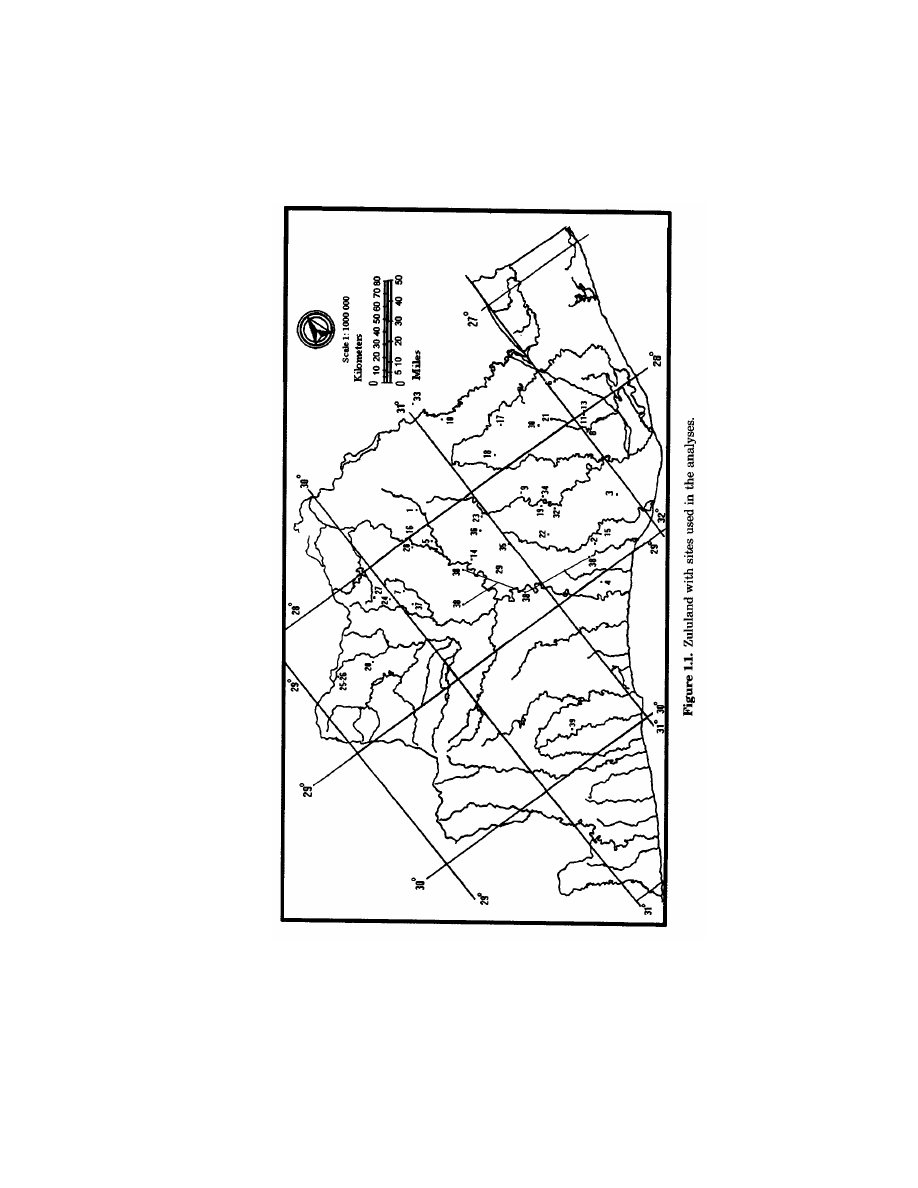
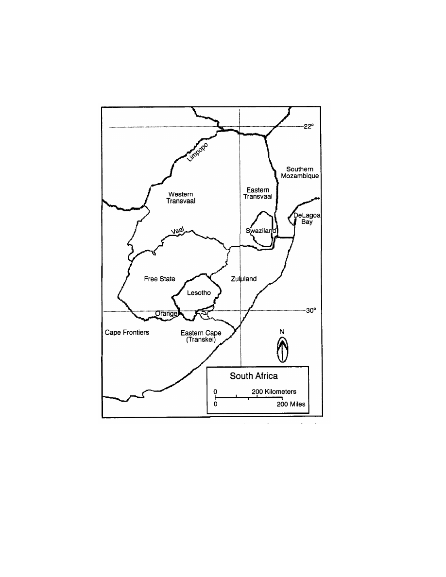
the Zulucentric scale of the Settler Model is adequate. Zululand (Fig.
1.1) is a dynamic geographical and political space. The Zululand
discussed herein includes the traditional area north of the Tugela
and Mnzinyati Rivers, to the east of the upper catchment of the White
and Black Mfolozi, Mnzinyati, and Phongola Rivers, and to the south
of the Phongola River in the modern province of Natal (Hall 1981, 25).
To evaluate the localness of the Settler Model, I study other
areas of southeastern Africa as well. The South African provinces of
the Transvaal, Natal, the Free State, and the eastern Cape east of
the Orange-Vaal confluence and south to the Sundays River are
included. Archaeological materials from Swaziland, Lesotho, and
southern Mozambique are also included (Fig. 1.2).
3
MIDDLE-RANGE THEORY: ARCHAEOLOGICAL
DATA AND THE DOCUMENTARY RECORD
In confronting a model drawn from documentary records with
archaeological data, I am dealing with a set of methodological issues
familiar to the field of historical archaeology, usually glossed with the
phrase Middle-Range theory. Leone and others (Leone and Crosby
1987; Leone and Potter 1988a, 1988b) have argued that for historical
archaeology Middle-Range theory involves forging a more productive
and meaningful relation between the documentary and archaeologi-
cal records by generating a methodology sympathetic t o the experi-
ences of others.
These authors criticized archaeologists concerned with the later
historical periods who link archaeological data and documentary
materials as dependent data sets in which the written and/or oral
record is generally checked against the “ground truth” of the archae-
ological record. Leone and Potter and Leone and Crosby argued that
both types of “facts” are generated by different people, generally of
different classes, races, times, and genders and often in a conflictual
context rendering them necessarily “epistemologically distinct” (Leone
Chapter 1
4
Southern Africa and the Archaeology of Impact
5
Figure 1.2. Zululand and other areas used in the analyses in the context of southern
Africa.

6
Chapter 1
and Potter 1988a, 14). Consequently a more broadly applicable
method must assume the independence of each line of evidence. This
approach allows a dialectical relation between archaeological and
documentary materials with each data set extending our information
about the other as well as our knowledge of the past (Hall 1992; Leone
and Potter 1988a, 1988b).
Middle-Range theory involves the construction from the docu-
mentary record of models that specify relations between people’s
activities, objects, and cultural landscapes and arranges them against
archaeological data to generate expectations and identify any dis-
junction (Leone and Crosby 1987,398; Leone and Potter 1988b, 13).
The “ambiguities” produced by the discrepancy between the archae-
ological and documentary records are the most critical elements in
this method. They can be used to formulate hypotheses accounting for
the particular documentary and material records. Furthermore,
these unexpected deviations can be used to construct questions about
the new contrastive case to direct future research strategies. In this
way, the archaeological record can contribute to recovering the char-
acter of each particular historical case and to deriving a new under-
standing of cultural domination and resistance. These data can be
used to enhance theoretical knowledge by facilitating the search
for the conscious social agency of marginalized individuals and
groups attempting to resist domination (Hall 1992; Leone and Crosby
1987,409).
All historical sources, oral texts and written documents alike,
were created to communicate a special kind of understanding, filtered
through various conscious and unconscious European and African
categories. They are thus psychological accounts revealing useful
insights into the social and intellectual history of the writer/speaker.
They are also ideologically charged by the social positioning of the
writer/speaker in terms of race, class, gender, and historical contexts
and say as much about the writers and speakers and their time as
they do about the past (Bonner 1983; Chanaiwa 1980a, 31; Hall 1990,
4). Consequently we need a much wider range of sources than his-
torical documents written by Europeans for their own consumption
and appeasement or oral traditions with similar motives of histori-
cally legitimizing a social group’s primacy. Thus all sources must be
read, listened to, and analyzed by “looking behind the documents and
memory in order to learn with archaeological aid as much as we can
about these earlier formations” (Wilmsen 1989, 64).

Southern Africa and the Archaeology of Impact
7
This is not to say, however, that archaeologists themselves are
unbiased. In fact, all archaeological and historical research is politi-
cally situated, especially historical archaeology where the relation to
ideology is more conspicuous. Historical archaeology can play an
important role in both sanctioning and exposing the current social
and power relations in contemporary society (Blakey 1983,1997; Hall
1984a, 1984b; LaRoche and Blakey 1997; Perry 1997b, 1998). For
instance, in southern Africa, African history is portrayed as white
southern African history, while other groups are represented in sepa-
rate contexts, disarticulated from the exploitative relations with
whites. Yet, the work of Schrire (1988,1996) and Hall and colleagues
(1990a; Hall 1992) has shown that historical archaeology does not
necessarily or only disclose and distinguish African societies from
white ones or working class social life from that of elites, but can
contribute a “domestic texture” absent in written documents by fo-
cusing on the roles played by material objects in the lives of ordinary
people asserting dominance and resistance (Hall 1992; Hall, Halkott,
Klose, and Richie 1990a, 84). To pursue these goals, we need to be
able to link the material objects, their archaeological contexts, and
their spatial relations to theoretical investigations of colonialization
processes by considering global-regional political and economic rela-
tions centered in a specific historical setting and guided by assump-
tions of conscious human agency. This approach allows historical
archaeology to play a crucial and necessary role in historical inter-
pretations by narrowing the possibilities and furnishing alternative
models (Hall 1990, 126).
In Chapter 2, I address the problem of the Mfecane/Difaqane by
exploring the historical literature for the various ways in which
southern African historians have explained the Mfecane/Difaqane in
the documentary record.

This page intentionally left blank.

The Mfecane/Difaqane
Problem from the
Documentary Record
2
THE STANDARD STORY
OF THE MFECANE/DIFAQANE
Much of the current historical research on southern Africa has fo-
cused on the pivotal role of the Mfecane/Difaqane and the consequent
Zulu state formation as the most important events in later southern
African history (Denoon and Nyeko 1986; Omer-Cooper 1966, 1988,
1995; Shillington 1987). Most explanations of these events have been
posed in terms of African internal economic dynamics, emphasizing
catastrophic population pressure, ecological conditions favoring soil
erosion, naturally increasing cattle herds depleting resources, and
overgrazing. Before moving to a consideration of each of these theo-
retical positions, I first present a sketch of the history of the Mfecane
Difaqane period.
Mfecane/Difaqane theorists argue that late eighteenth-century
political upheavals in local polities in the area that was to become the
Zulu heartland (Fig. 2) were the result of various internal conditions
focusing on anthropogenic environmental change. Thus, the earliest
nineteenth-century “destructive waves” of the Mfecane/Difaqane
should evidence themselves in the Mfolozi-Phongola region.
Conflict between different groups in the Mfolozi-Phongola region
over the need for grazing land resulted in livestock raiding by the
more powerful polities and extensive migrations by those less power-
ful. The confrontations also involved refugees attacking other polities
in their path as they fled the Mfolozi-Phongola region. The scale of
this devastation is said to have been heretofore unknown in southern
Africa. The perpetual state of contention among the groups in this
region culminated in the emergence of a hierarchy of centralized
military polities, at the apex of which stood the Zulu state (Omer-
Cooper 1966, 157).
9

10
Chapter 2
The emergence, proliferation, and dispersion of military polities
drastically altered regional power relations and had significant con-
sequences for the political economy of nineteenth-century southern
Africa far beyond the margins of the Zulu state. The violent disloca-
tion of and incursions by African polities like the Zulu against other
agropastoral communities prompted further political and economic
transformations in outlying peripheral communities.
This model posits conflict between different “ethnic” groups and
allows comparison between documentary differentiation of these
communities and the archaeological record. Historical accounts also
provide a chronological framework for tracing the earliest reverbera-
tions from a chronological framework for tracing the earliest rever-
berations from the Zulu kingdom under Shaka (ca. 1815) through the
various migrations out of the heartland onto the borders and ending
with Zulu raids on the eastern Cape frontier (ca. 1828). The chrono-
logical ordering proposed in this version, however, refers only to the
times when fissioning militarized polities from the Zulu heartland,
or from regions devastated by them, invaded a specific area.
Omer-Cooper argued that these chaotic conditions invited Euro-
pean intervention. European missionaries, traders, and others living
beyond the encroaching European frontiers were simply caught up in
the turmoil, He (1988, 66) explained that:
The previously thriving population of Natal was particularly disrupted.
Many fled south. Others hid themselves in extensive areas of dense bush
leaving most of the land apparently deserted apart from the vicinity of
Port Natal where a community of about five thousand lived under the
protection of the English traders. (Emphasis added)
Omer-Cooper implied that the African presence at Port Natal is
a consequence of the Mfecane/Difaqane and that only after 1838 when
the Boers defeated the Zulu of Digaane did the African populations
of Natal, who had fled the Mthetwa-Zulu under Shaka, return.
DEMOGRAPHIC EMPHASIS
Demographic arguments have emphasized varying population
stresses (e.g., Gluckman 1960; Omer-Cooper 1966,1988; Service 1975;
Shillington 1987; Stevenson 1968). Gluckman (1960) was the first to
suggest that population pressure led to increased competition for
land, generating conflict that culminated in intra-African warfare.

The Mfecane/Difaqane Problem from the Documentary Record
11
Omer-Cooper’s (1966) classic The Zulu Aftermath had the most
effect on later African historiography; it popularized the concept of
Mfecane as a unique historical event that brought a violent, dra-
matic, and sudden end to centuries of southern African social stag-
nation (Hall 1990; Webster 1991). His model was the first to give
primary attention to internal African dynamics. Like the colonialist
historians who preceded him, he upheld the “great man” theme,
focusing on the character and innovations of Shaka as Mfecane/
Difaqane initiator (Eldredge 1995; Etherington 1991b). His original
formulation offered a detailed explanation of Zulu state emergence
based on catastrophic population pressure and a lack of grazing land.
Although Europeans’ encroachment from the Cape was mentioned,
their role was seen as secondary. By interpreting the warfare and
population dislocation as associated with independent African state
formation, he debunked the myth of impotent African polities. Omer-
Cooper (1988,53) has since amended his original formulation and has
allowed for the effects of the ivory trade at Delagoa Bay.
ECOLOGICAL EMPHASIS
Some explanations for Zulu state formation rest on internal
ecological processes rooted in transformations in the productive
forces that gave rise to conditions of environmental deterioration
provoking expansion and conquest. It has been suggested that a lack
of grazing land produced by extensive overgrazing and a decline in
land productivity resulting from soil erosion, drought, disease, and
increasing human and stock densities were major causes of the Zulu
state’s rise (Guy 1980,1982; Marks 1967a).
Bonner (1983) looked at the rise and functioning of the nineteenth-
century Swazi state with an emphasis on the interrelations of local
and external forces but rejected ideas that whites were a unifying
factor. He argued that access to European trade challenged the power
and authority of the elders and facilitated political transformation.
These changes were intensified by the Mdlatule famine and drought.
The ethnohistorical and ethnographic documents suggest that
from the 1790s to the beginning of the nineteenth century in Swazi-
land and southern Mozambique a severe drought resulted in famine.
This drought occurred at Delagoa Bay in 1791-1792 and reduced
African populations’ access to foodstuffs (rice and vegetables) from
the interior (Delius 1983,18; Hedges 1978,145-46). Other droughts

12
Chapter 2
ensued around the Bay in 1800, 1803, 1812 and 1816-18. In the
absence of any paleoecological evidence for supporting or rejecting
the drought hypothesis, no positive determination can be reached. I
suggest that we should not neglect the role of political events in
promoting famine.
First, Bonner stated that “regional ecological complementarities”
promoted earlier intraregional trade and altered social relations in
and between lineages and homesteads. Some lineages with access to
particular resources exchangeable for cattle, such as iron, could accu-
mulate cattle and subsequently could lend surplus cattle, allowing
penetration of the reproductive cycle of other lineages and resulting
in the expansion and dominance of such kinship units. Thus, the
increased demand for rare prestige goods like ivory and cattle broke
the established social order (Bonner 1983,13-14).This allowed some
groups to circumvent the power of the lineage elders, generate a
following, and dominate and extract tribute over a wide area.
Second, labor could not be effectively organized in the prevailing
hierarchical lineage organization. Large-scale hunting and burning
enhanced agropastoral production and required the coordination of
larger groups than before. This political reorganization also provided
a framework for military parties.
These two factors combined to raise dominant lineages into posi-
tions of authority in larger scale, more diverse political structures.
The resulting new polities were incorporated by an ideology in which
kinship was dichotomized into aristocratic and commoner poles.
Thus external trade and its exotic products subtly changed the inter-
and intralineage relations. The elders’ authority at the homesteads
was dependent on their control over access to cattle for bride-wealth
payments. Elders also controlled the marriage ofjuniors by granting
permission prenuptially only in exchange for labor services and sur-
plus labor products until cattle were repaid. Trade threatened these
homestead-lineage relations by enabling juniors’ access to cattle,
marriage, and the like. Consequently the elders of elite lineages
sought to secure a monopoly of all intraregional trade to maintain
their privileged position and control over social reproduction and
material production itself (Bonner 1983, 13).
Daniel (1973) proposed a geographical model of the environment
as “perceived” by pre-Mfecane/Difaqane early nineteenth-century
southeast African societies in southern Swaziland and northern
Zululand, a region of the lower Mfolozi valley that spawned the
growing Mthetwa-Zulu power. This useful regional investigation
revealed some actual locations of royal capitals and discovered gen-

The Mfecane/Difaqane Problem from the Documentary Record
13
eral spatial and ecological relations between the sites as well. Daniel
illustrated that the powerful, emergent late nineteenth-century poli-
ties were based on similar configurations of natural resources. This
suggested to Daniel that these polities were seeking to control the
most productive combination of grazing lands and agricultural soils
in zones with a low incidence of drought. He concluded that competi-
tion for control of these pasture lands was the cause of the rise of
the Zulu state.
As pointed out by Hall and Mack (1983,182), one major problem
with Daniel’s study was the use of Acocks’s (1953) generalized vege-
tation maps. These static maps are based on twentieth-century vege-
tation patterns and allow for neither local variation nor specific past
land-use practices. Marker, a geographer, and Evers, an archaeolo-
gist, examined soil erosion in the Lydenburg Valley of the eastern
Transvaal(1976,163-4)and found an association between some later
historical settlements and localized soil erosion. This association was
attributed to overpopulation and changing land-use patterns. The
authors noted that during earlier periods of soil erosion, populations
had simply moved nearby, but during 1826-27 these areas were
completely abandoned.
Guy (1980,1982) argued for a population explosion in what was to
become the Zulu heartland, which caused increased cattle herding
and led to extensive overgrazing and environmental degradation. Such
“unscientific farming practices” combined with drought-engendered
famines further intensified conflict and gave rise to the Zulu state.
Following Daniel, he reasoned that southern African agropastoral
societies in the core area required access to a wide range of veld types.
This need for greater environmental variety dictated settlement loca-
tion and forced these polities to expand their territorial dominion.
Eldredge (1995) pointed out that Guy’s environmental degrada-
tion model neglects cultivation in his analysis of the agropastoral
production process. Guy did mention the trade at Delagoa Bay but
argued for its insignificance, because he saw no change in processes of
production or distribution (Guy 1980, 102-19). In fact, Guy argued
that despite capitalist penetration the Zulu kingdom endured until
the end of the Anglo-Boer War (Etherington 1991a, 10).
VINDICATIONIST ARGUMENTS
In the United States, some early African-American scholars
challenged the prevailing views of colonialist historiography, and

14
Chapter 2
explained the Zulu revolution as a struggle to consolidate southern
Africans and to resist European penetration (Diop 1974,169; DuBois
1969, 31;
Clarke 1970, 35; Rodney 1981, 128-32). This explanation
was generally ignored by South African and European scholars until
recently,
Chanaiwa (1980b) presented an African vindicationist argument
that the Zulu state developed from an elaboration of conditions al-
ready extant among precontact Africans. He argued that the Zulu
state formation was the result of embryonic, institutionalized class
development and wealth concentration exacerbated by aristocratic-
commoner antagonisms. Furthermore, he suggested that the Zulu
adopted through active conscious human agency a secular subjective
outlook on their own destiny by choosing military resistance to main-
tain autonomy over migration or refugeeism. This outlook freed them
from ethnic and territorial boundaries, despair, and inaction. Finally,
the Zulu revolution offered every able-bodied man an opportunity to
acquire cattle, despite earlier disadvantages of birth, rank, class,
and political power.
EXTERNAL TRADE
Several Africanist historians have carefully tried to relate extra-
continental factors to internal ones by focusing on the historical
conditions underlying the transitions. Wilson (Wilson and Thompson
1969-1971)
was the first to suggest this idea, but models focusing
on trade in southern Africa were pioneered by Alan Smith (1969) and
subsequently refined by others, most of whom related the ivory trade
at Delagoa Bay to the rise of the Zulu state (e.g., Carlson 1984; Hedges
1978;
Slater 1976). Still others examined the contraction of this
trade in the context of the rise of later states like that of the
nineteenth-century Pedi (Delius 1983), the Swazi (Bonner 1980,
1983),
and the Sotho (Legassick 1969, 1980). Essentially, the trade
proponents argued that inter-European and intra-African political
and economic conflicts over control of trade resulted in indigenous
transitions in African sociocultural institutions. Specifically, trade
intensified class conflict and maneuvering and became an exclusive
prerogative of the elite
for
distribution of rare items to other elites,
favorite retainers, and other members in the prestige systems to
generate aristocratic wealth accumulation and power.

The Mfecane/Difaqane Problem from the Documentary Record
15
Alan Smith (1969) examined the role of the ivory trade in class
formation and wealth accumulation from a European perspective. He
hypothesized that the principal factor in the rise of the Zulu state
was the commercial competition to monopolize the ivory trade with
European and Indian merchants at Delagoa Bay, which caused riva-
lries among several southeast African polities in the Zulu core area.
He used published sources on European commercial activity to dem-
onstrate that the main export at Delagoa Bay was ivory and that as
this trade increased the Ndwandwe, Ngwane, and Mthetwa-Zulu
ruling groups and later the Zulu used imported exotic items to accu-
mulate wealth and power.
Slater (1976) recognized the significant role of the amabutho
1
or
age-regiment system in transforming African society. He argued that
the Zulu state resulted from structural changes precipitated by its
reorganization through the institutionalization of the amabutho.
This militarization was no longer just defensive; it became a means to
recruit and support armies and to generate state wealth through
captive raiding and cattle raiding and accumulation. The contradic-
tion lay in the fact that sustained raiding induced counterattacks,
making defense a priority. The need for defense led to nucleated
populations and political concentration (Eldredge 1995). Slater pro-
posed that the expansion of the ivory trade in the Delagoa Bay region
led to an increase in commodity production in those African polities
involved in trade and inevitably led to internal political conflicts as
elites attempted to broaden their control over local production and
commercial relations.
Hedges (1978) looked at the ivory trade from an African perspec-
tive in terms of the development and transformation of African politi-
cal and economic institutional structures that translated trade items
into power. Hedges assumed suitable economic conditions and suffi-
cient political power to initially control trade routes and maintained
the view of bounded political units. Nonetheless, he recognized the
political functions of kinship institutions, which permitted him to
identify the potential for incorporated groups to manipulate, create,
and rearrange their dominant lineages’ traditions of origin so as to
claim a common origin justifying new political relations.
1
This term refers to age grades, which were initially local institutions crosscutting kin
organization and initiating men and women into adulthood through circumcision. Be-
cause male age grades served to provide hunters for royal hunting parties, they had the
potential to function politically as coercive institutions by which the aristocracy could
obtain war captives, animal skins, and ivory (Hedges 1978).

16
Chapter 2
Hedges proposed a two-period expansion of trade at Delagoa Bay.
During the 1750s-80s, ivory imported from south of the Bay accom-
panied geographical expansion of centralized polities in the Delagoa
Bay-Thukelaregion. During the 1780- OS, the ivory trade collapsed
and cattle, destined for United States whalers at the Bay, also coming
from the south, replaced ivory as the major trade item. Although both
products were important for southern African polities, ivory was a
“prestige” item, acquired at least initially as a byproduct of hunting,
whose circulation was dominated and controlled by elites. In con-
trast, cattle expropriation had devastating economic and social ef-
fects on both elites and commoners and hence on southern African
polities and culture in general.
The transition from ivory to cattle export would have produced
lower transport costs, because unlike ivory, which had to be carried
overland by human labor power (Thorbahn 1984), cattle could trans-
port themselves. Problems still existed, however, such as piracy,
disease, and storage, all of which led to the need for guarding and
protection. Restrictions in access to cattle had detrimental effects on
all African households, especially those of commoners. Hence, cattle
exports caused a severe drain on local economies and resulted in
African military institutions that functioned as cattle-raiding vehi-
cles and wars for the acquisition and protection of cattle and control of
grazing lands, further necessitating effective sociopolitical organiza-
tion. Thus Hedges concluded that this competition between African
polities was the crucial factor in the emergence of the Zulu state.
Eldredge (1995) presented a synthetic explanation of the Mfecane/
Difaqane, which involved factors governed both by the physical envi-
ronment and by Delagoa Bay trade. She argued that an environmen-
tal crisis, presumably a drought, initiated a scarcity of food resources,
which resulted in famine and increased competition for productive
resources. Groups with locational advantage had greater access to
food resources and were differentially empowered.
Furthermore, as local and regional ivory trade grew, elephant
herds declined, reducing ivory exports. Because the ivory trade had
not promoted a surplus based on agricultural intensification, local
and regional production could no longer sustain continual surplus
extraction. The need to increase cultivation demanded more labor;
women were especially valued as they provided essential agricultural
labor as well as offspring for social reproduction. This situation pro-
voked conflict and competition over access to productive land and
people. Sharper elite competition for these diminishing resources led
to violent struggles for dominance and survival (Eldredge 1995).

The Mfecane/Difaqane Problem from the Documentary Record
17
The elite of those polities able to secure agropastoral productive
lands could now have better access to and control of high-status
imported commodities, surplus labor, and food resources. This combi-
nation of elements promoted the political consolidation of elite power
and the economic growth at the expense of those groups less well
situated. Peripheral communities were differentially incorporated
into the lower hierarchical levels of the dominant polities, accelerat-
ing social inequality in and between local polities. It is in this socio-
political and ecological setting that “strong leaders” like Shaka, “who
ruled with terror,” acquired a following, and incorporated neighbor-
ing polities (Eldredge 1995).
Of the trade proponents considered so far, most of which present
materialist explanations of state formation in southeastern Africa,
all emphasize African-European interaction, and all venture beyond
explanations of African-induced internal warfare. Most authors see
trade as facilitating the restructuring of the productive relationships
and the transformation of sociopolitical institutions in and between
the polities of the Delagoa Bay-Thukela region. One result of this
reorganization was an increase in elite power and authority, which
according to some authors differentially subjugated conquered peo-
ple rather than fully incorporating them. Finally, all explanations are
couched in a historical rather than strictly ecological, demographic,
or evolutionary context while seeking to address the question of why
internal and external political relations were ripe for change at this
particular time and place.
COBBING’S REANALYSIS
Threads of an alternative analysis that undermines the geo-
graphic localism and European passivity of the Settler Model can be
found in the work pioneered by Macmillian and his student Diewiet
during the late 1920s and early 1930s but dismissed in the academy
and political institutions of South Africa (Saunders 1995). This work
has most recently been resurrected and elaborated on by Cobbing
(1988), his students (Webster, 1991,1995), and others (John Wright
1990, 1995a, 1995b, 1995c, 1997).
Cobbing’s (1988) inspiring initial reformulation of the Mfecane/
Difaqane with its powerful new insights precipitated the destruction
of the Zulucentric Mfecane/Difaqane myth, transcending the old
paradigm and igniting a serious rethinking of early-nineteenth-
century southern African history. He presented a provocative and

18
Chapter 2
enlightening argument that debunks many of the assumptions of
the Mfecane/Difaqane theorists. It raises a host of questions and
issues extending from the origin and identity of established southern
African terminology to the magnitude and role of imperial European
agency in the form of surrogates like missionaries, colonial officials,
traders, early colonialist historians, and the Griqua and their rela-
tions to the slave trade at Delagoa Bay and the Cape. His rigorous
inquiry is supplemented by an expansive, meticulous analysis of
the fundamental conflicts and contradictions inherent in colonial
struggles among all members of the capitalist social formation in
nineteenth-century southern Africa.
Cobbing’s expansive scope submits that Zulu military conquests
were but one manifestation of an emergent capitalist global political
economy impinging on southern Africa long before the emergence of
the Zulu state. He seeks to illuminate African-European settler inter-
actions by implicating African and European polities involved in
slaving. Slaving supplied labor for external plantations and even
more desperately needed local labor for internal colonization by
means of trading and raiding campaigns representative of mercantile
capitalism that radiated far beyond the highveld or Zululand. There-
fore the notion of an internal revolution solely in terms of Zulu agency
is both myopic and inaccurate because organized military regiments
and innovations as well as continual exchange relations between
southeast African polities and Europeans preceded and persisted
throughout the reign of Shaka and Zulu state emergence (Cobbing
1988,485).
Cobbing contends that the Mfecane/Difaqane is linked to disrup-
tive, destabilizing European forces emanating from the Cape, south-
ern Mozambique, and other European colonies in southern Africa,
which were in turn inextricably bound to the developing global cap-
italist social formation (Etherington 1991a, 3 and 12). The scope and
scale of these forces have heretofore been purposely ignored by a
settler version of South African history that considered the simul-
taneous events of the Great Trek and the alleged African self-
destruction of the Mfecane/Difaqane as isolated occurrences.
Cobbing focuses on the role of slave raiding in precipitating
internal conflicts and asserts that slaving was the most consequential
determinant disrupting African societies in the Delagoa Bay and
Cape areas. Slaving altered demographics and social relations, in-
cited political instability, converted social reproduction, and thus
forced a restructuring of African polities in the region. Furthermore,

The Mfecane/Difaqane Problem from the Documentary Record
19
he insists that European farmers, traders, and missionaries were in
collusion and that their agents the Griqua and Korana were the prin-
cipal sources of violence in the interior (see Eldredge 1995, Hamilton
1995, Hartly 1995, and Wright 1995c, who challenge Cobbing’s views
on the role of European collusion).
The work of Harries (1981) and Lovejoy (1983,1989), although not
attempting to describe the connection between the Mfecane/Difaqane
and the slave trade, clearly demonstrates that during the sixteenth
century the external slave trade heavily affected southeast Africa. By
the late seventeenth century, the European colonial frontier and the
slave trade simultaneously expanded; by the eighteenth century, a
vibrant slave trade dominated commerce between Europeans and
Africans (Cobbing 1988, 496), and internal factors intensified slavery
as the external trade contracted during the nineteenth century
(Lovejoy1989, 390).
Cobbing concludes that the Mfecane/Difaqane fable is “a tena-
cious and still-evolving multiple historical creation of the white su-
premacist version of history” and a critical linchpin of apartheid
propaganda legitimized in scholarship, media, and cinema (see Ham-
ilton 1989). It also serves as a multiple “alibi” removing any need
for an explanation of the African past by ignoring and/or concealing
massive external imperial agency to authenticate white occupation of
the land and the ideology of separate development. Cobbing’s expla-
nations of the spatial distributions of white population movements
augmented by the dearth of evidence for Zulu agency make very
compelling grounds to repudiate the Mfecane/Difaqane myth as an
explanation for the depopulation and destruction of the interior Afri-
can societies (Hamilton 1995). The concept of Mfecane/Difaqane is
Zulucentric, ideologically “loaded,” and historically erroneous, and
its ponderous apartheid baggage renders it untenable as a neutral
descriptive historical category, because it is devoid of any analytical
utility, it cannot be revived and must be abandoned (Cobbing 1988,
487 and 519).
Not surprisingly, such a strong critique has engendered consider-
able controversy. Much of it centers on the lack of records support-
ing an extensive slaving economy centered on Delagoa Bay (e.g.,
Du Bruyn 1991; Eldredge 1995; Etherington 1991b; Hamilton 1995;
Meintjes 1991). We must be aware that slaving was illegal and there-
fore required the development and use of various euphemisms to
cloak slaving activity. In addition, slaving was an extremely profit-
able enterprise that could generate power and finances to maintain

20
Chapter 2
missions and increase converts while keeping the overseeing agen-
cies at “home” ignorant, or at least apathetic and happy. In the final
analysis, this seems to be precisely the kind of case where an indepen-
dent source of data, such as archaeological evidence, might help
resolve the matter.
SUMMARY
The historical discourse about the forces underlying the Mfecane/
Difaqane has focused on the standard story, a Zulucentric version of
African internal dynamics. Explanations have emphasized various
anthropogenic environmental “causes” like ecological and demo-
graphic change. Vindicationist arguments from scholars of the Afri-
can diaspora differed from their European counterparts in accentuat-
ing pride in Shaka’s military accomplishments and some recognition
of European agency. Trade advocates, with the exception of Cobbing,
maintained Zulucentric explanations that recognized African-European
interaction but emphasized African conflictual relations over European-
controlled commodities imported from Delagoa Bay.
Despite the variance in the range of debate over the Settler
Model, the major shape of the arguments remains clear. The Mfecane/
Difaqane was precipitated by Zulu state formation and was the re-
sult of African internal dynamics. Even those who consider external
interaction keep the variation minimal by not looking beyond Dela-
goa Bay. I have tried to show that there is only minor variation among
explanations for the Mfecane/Difaqane and all the variance is rooted
in the standard Settler Model. In Chapter 3, I describe the key issues
in the standard story to generate the archaeological implications.

Archaeological Correlates
of the Settler Model
3
This chapter addresses the problem of generating archaeological
expectations for the standard story accounts by looking at ethno-
graphic and ethnohistorical descriptions of the various African com-
munities inhabiting the area affected by the Mfecane/Difaqane
Matching documentary and archaeological records is often difficult
because historians have an interest in social relations and tend to
treat material culture as background, only rarely describing it in the
detail needed for analysis. Therefore, to move to a comparison of these
data sources, I have to translate, if you will, the historical accounts
into archaeological expectations.
The goals of this chapter are (1) to show that each of the different
“explanations” of the Mfecane/Difaqane shares a common set of as-
sumptions about the nature of ethnic groups, their geography, and
their history-inother words, the standard Settler Model of the
Mfecane/Difaqane; (2) to present some archaeological correlates of
the Settler Model as a means to assess its adequacy against the
archaeological data. The chapter concludes with a listing of the spe-
cific types of sites predicted by the model for pre- and post-Mfecane/
Difaqane, their architectural and artifactual contents, and their loca-
tions.
ETHNOGRAPHIC
AND ETHNOHISTORICAL DESCRIPTIONS
The standard Settler Model of southern African history espoused
by Omer-Cooper and others is anchored in three assumptions about
pre-European-contact southern African people. The first anchor is
the idea that southern African society was composed of a series of
relatively discrete ethnic groups that had their origin in the past and
that persisted into relatively recent times. The second assumption of
the settler version of southern African history is that these ethnic
21

22
Chapter 3
groups were poorly articulated one to the other-that
little systemic
interaction between the groups can be used to understand cultural
transformation. The third is the Zulucentric focus discussed in the
previous section, namely, that these social relations were disrupted
in the early nineteenth century by the Mfecane/Difaqane when local
conditions led the pre-Zulu ethnic group to become a predatory state.
It is in the context of the settler paradigm that the Mfecane/
Difaqane proponents interpreted southern African history. A partic-
ularly key element is the so-called Bantu migration theory, This
theory posits the relatively recent and rapid occupation of southern
Africa by the migratory Bantu ancestors of the modern African people
now inhabiting southern Africa (Huffman 1970; Phillipson 1993; see
Diamond 1994, for a recent example of the uncritical acceptance of
the Bantu migrations theory). This theory assumes that a new “race”
of “Bantu” people, characterized by a common physical type, lan-
guage, and set of cultural traits including metallurgy, agriculture,
distinctive pottery, and animal husbandry, arrived in southern Africa
and replaced or absorbed the earlier Ju/’hoansi (Khoisan) “race” (see
David 1980 and Hall 1990 for attempts to debunk this theory). For
instance, Omer-Cooper notes:
In South Africa the Bantu were relatively recent immigrants.... [I]t is
unlikely that they were south of the Limpopo in any considerable num-
bers before the twelfth century
AD at the earliest. (Omer-Cooper 1966,12).
Some evidence for this theory comes from the archaeological rec-
ord. For example, because ceramics were part of the cultural traits
associated with migrating Bantu, the apparent ceramic stasis of post-
fifteenth-century, pre-Mfecane/Difaqane southern Africa disclosed
the spatial location of these ethnic groups.
As these later [pottery] forms have remained virtually unaltered until
recent times, it seems almost certain that immigrants who brought them
were ancestors of the present-day branches of the Bantu speaking peo-
ples of South Africa. (Omer-Cooper 1988, 8)
Other evidence comes from the documentary record. For example,
Omer-Cooper states:
Accounts of Portuguese sailors shipwrecked on the east coast, together
with oral tradition,... [suggest that] the Xhosa, vanguard of the Nguni
group, were settled near the upper Umzimvuba by 1300 and possibly
considerably earlier and that by 1593 they had reached as far south as
the Umtata River.... By the eighteenth century they had reached the Fish
River and were beginning intensive settlement still further west when

Archaeological Correlates of the Settler Model
23
they encountered the first Boer farmers moving up the coast in search of
grazing land. (Omer-Cooper 1966, 13)
Hence, Mfecane/Difaqane theorists postulated certain pre-
Mfecane/Difaqane ethnic group distributions, and settlement and
architectural types farther into the past. Consequently, ethnographic
and ethnohistorical descriptions of the various African communities
inhabiting the area affected by the Mfecane/Difaqane can be ab-
stracted and presented to examine the hypothesized locations and
the archaeological correlates of these ethnic communities.
Many Africanist scholars have provided maps for different pre-
Mfecane/Difaqane time periods (sixteenth through nineteenth centu-
ries) indicating the distribution of the different ethnic groups in
southern Africa (Bryant 1929 in Hall and Mack 1983, 167-68; Ha-
rinck 1980, 170; Hedges 1978, 10, 118, 136, 166, 171, 179; Legassick
1969,123-25; Omer-Cooper 1966, 11,26; Shillington 1987, 13 and 27).
Almost all these authors have, at least implicitly, followed the Bantu
migrations and Mfecane/Difaqane paradigms.
The consensus is that there were three major groups of people
in southern Africa during the last five hundred years, two of whom,
the “Nguni” and the Sotho-Tswana (Sotho and Tswana), belong to the
southern “Bantu.” The third major group, the Ju/’hoansi (Khoi-Khoi
and San or Khoisan), are thought to be the original inhabitants of
southern Africa before the Bantu migrations. The traditional wisdom
is that Nguni and Sotho-Tswana agropastoralism allowed a much
more rapid population growth and relatively high population densi-
ties and encouraged a more complex sociopolitical organization than
the pastroforaging Ju/’hoansi (Khoisan) groups they encountered.
Culture change, as discussed in the previous chapter, came about in
Zululand with the resultant development of an expansionist state
that disrupted the social relations among these various ethnic groups.
Evaluating the Settler Model involves developing archaeological
correlates for various presumed actions. I begin by discussing the
characteristics of each of the presumed initial major ethnic groups
before the changes wrought by the Mfecane/Difaqane Then I con-
sider features of southeastern polities expected under the Settler
Model following the onset of Zulu state formation. This allows us to
assess by means of archaeological material whether isolated ethnic
groups of the character presented in the standard model precede the
Mfecane/Difaqane and whether Zulu state formation precedes the
disruptions of the Mfecane/Difaqane.

24
Chapter 3
PRE-MFECANE/DIFAQANE GROUPS
OF EASTERN SOUTHERN AFRICA
Nguni
Omer-Cooper (1988, 8) suggests that at contact the southern
Nguni occupied the coastal lands between the Drakensberg and the
Indian Ocean in and around the areas where the Mfecane/Difaqane
was alleged to have originated. The Zululand area and its pre-Mfecane/
Difaqane inhabitants are described by Omer-Cooper:
Before ... the emergence of the Zulu kingdom under Shaka, Zululand and
Natal were the home of a large number of relatively small Nguni tribes.
(Omer-Cooper 1969, 208)
These populations were ... virtually hemmed in between the moun-
tains and the sea and had no outlet to the as yet unoccupied or sparsely
inhabited lands to the south except by forcing a way through the nu-
merous tribes of Natal. (Omer-Cooper 1969, 213)
[They] ... had been in occupation of most of the coastal corridor ... for
several centuries and the population in parts of the northern end of this
corridor had been relatively dense from at least as early the seventeenth
century. (Omer-Cooper 1969, 208)
Omer-Cooper, like most disciples of the traditional wisdom, fol-
lowed Bryant’s descriptions of the “Nguni” as an almost timeless
homogeneous people in the past. In this context, “Nguni” was/is an
ethnic designation applied to all pre-Zulu, non-Ju/’hoansi (Khoisan),
non-Sotho-Tswana peoples in southeast Africa. This notion has since
been challenged by a number of authors (Hedges 1978, Appendix I,
253-57;Marks 1967b, 1969; Wright and Hamilton 1985,1996). Re-
gardless of its origins, I use this term because it has been incorpo-
rated into the Settler Model.
Settlement Pattern and Residence
At contact, Nguni lived in dispersed isolated settlements on hill
slopes with water, fuel, gardens, fields, and pastures all within walk-
ing distance (Schapera 1967,151. Mfecane/Difaqane theorists, using
the “typical” Zulu homestead as a model, assume that all Nguni were
characterized by similar overall architectural oppositions dubbed the
“Bantu/central cattle pattern” by Huffman (1982, 1984, 1986).
The Bantu/central cattle pattern consists of settlement units
spatially distinguished by:

Archaeological Correlates of the Settler Model
25
A cattle enclosure at the center of every settlement contain-
ing underground grain storage silos and serving as a sacred
burial ground for local male ancestors.
An outer arc of circular dwellings located near agricultural
fields, with the principal dwellings of the homestead head at
the highest elevation up-slope of the central enclosure. The
remaining dwellings in commoner homesteads were occu-
pied by extended family members. Elite homesteads were
inhabited by wives arranged according to seniority and sta-
tus on either side of the primary dwelling to form a semi-
circle. To the left were lower-status “left-hand” wives, and
to the right were higher-status “right-hand” wives.
3. The
interior
spatial
layout
of
the
homesteads
and
the
dwell-
ings was also symbolized by rigid male-right/female-left divi-
sions, usually oriented at right angles to a sacred-back/
secular-front distinction (A. Kuper 1980, 1982; H. Kuper
1986). Homestead entrances were usually oriented downhill
facing east, on sloping ground directly opposite the entrance
of the central cattle enclosure.
4. A
men’s
court
was
in
or
adjacent
to
the
central
enclosure.
This central zone between the dwellings and the central
livestock enclosure formed the area for public meetings,
court procedures, political discussions, and ceremonies.
1.
2.
Sotho-Tswana
The migrations of the Sotho-Tswana into southern Africa and
their subsequent dispersal throughout southern Africa are explained
in the following manner:
The first [Sotho] migration may have entered Bechuanaland [modern
Botswana] in the thirteenth or fourteenth century, and the ancestors of
the present Tswana peoples were settled near their present habitat by
about 1600. (Omer-Cooper 1966, 14)
The origin of the Kgatla Kwena chiefdom clusters was the main
historical development in the Sotho-Tswana area from the sixteenth to
the late eighteenth century ... [and] ... the expansion of these groups
seems to have pushed some others into arid country on the fringes of
cultivable land where they came into particularly close contact with
surviving Khoisan groups. (Omer-Cooper 1988,16)
At European contact, the Sotho-Tswana inhabited the interior
plateau region and less well watered areas west of the Great Escarp-

26
Chapter 3
ment. There were a substantial number of eastern Sotho who, since at
least the seventeenth century, populated portions of the eastern
Transvaal (Meyer 1984,224). Because of the scarcity of good grazing
land in these areas, agriculture was emphasized over livestock herd-
ing until recently (Legassick 1969, 1-18). Today the Sotho-Tswana
populate Bophuthatswana, the Free State, and Lesotho. They are
also scattered throughout Swaziland, Zululand, and the northern
and eastern Transvaal among the Nguni.
Settlement Pattern and Residence
At European contact, the Tswana lived in large centralized
towns surrounded by several miles of agricultural fields and exten-
sive grazing lands, with cattle often kept at outposts located away
from the towns (Shillington 1987,151. The Sotho lived in large com-
pact villages larger than Nguni homesteads but smaller than Tswana
towns although similarly structured (Omer-Cooper 1988, 10).
Colonial Sotho-Tswana settlements, towns, and village units
typically ranged from 50 to 300 inhabitants (Schapera 1967). They
were divided into wards or hamlets consisting of groups of patri-
lineally related families concentrated around the senior clan head’s
dwelling. The ward or hamlet was often in a single settlement but
could also be scattered over the countryside (Legassick 1969, 99).
Sotho-Tswana settlements surrounded a centrally located cattle en-
closure. Although Sotho-Tswana ranked their wives, they did not
organize left- and right-hand houses spatially (Omer-Cooper 1988, 12).
Ju/’hoansi (Khoisan)
The term Khoisan is a combination of the terms San and Khoi-
Khoi. Both these terms were used by Europeans to describe pas-
troforaging communities in southern Africa (for a thorough discus-
sion of these terms see Lee 1979,29-38,1993; Wilmsen 1989,24-26,
regarding San; and Elphick 1977, xxi-xxii, considering Khoi). Ac-
cording to Lee (1979, 31 and 38, and 1993) the term Zhu/twasi or
Ju/’hoansi (“real or genuine people”) and the term Khoi (“the peo-
ple”) are the terms preferred by the people themselves. For our pur-
poses, the term Ju/’hoansi is used. Khoisan is used only in direct
quotes from Mfecane/Difaqane theorists and when explaining some-
thing about the term itself or its constituents.
Omer-Cooper describes the Ju/’hoansi (San in this case) as:

Archaeological Correlates of the Settler Model
27
the most ancient of southern Africa’s surviving peoples ... [who] ... were
hunting and gathering people who practiced no agriculture and kept no
domestic animals except dogs. (Omer-Cooper 1988, 3)
In the Settler Model then, the Ju/’hoansi, unlike the agropastoral
Nguni and Sotho-Tswana, are assumed to be gatherer-hunters-
with no cultivation. Documentary descriptions of Ju/’hoansi pastro-
foragers have most often focused on the polar types Khoi and San,
labeling these in terms of ethnicity. Omer-Cooper distinguishes be-
tween the Khoi and the San in terms of political organization, econ-
omy, environment, and ethnicity. For instance, Khoi polities were
based on cattle, whereas San “bands” were grounded in a gatherer-
hunter economy. In describing ethnic differences he says:
In South Africa and Namibia the San coexisted with a related people
known as the Khoi-Khoi.... The two peoples together constitute the group
known as the Khoi-san peoples. The origins of the Khoi ... are still not
known with certainty. It seems most probable that they began as a
community of San who were in close contact with Bantu-speaking cattle
keepers and adopted pastoralism from them. (Omer-Cooper 1988, 5)
This view can be compared with Shillington’s (1987, 6) descrip-
tions of the pastoral mode:
Compared with the San, the Khoi-khoi lived in larger, more settled
communities ... because their livestock provided them with a steady
supply of food close at hand. Nevertheless it was still necessary for them
to move settlement several times a year... between mountain, valley and
coast.
Settlement Pattern and Residence
Historical and ethnographic descriptions of Ju/’hoansi have fo-
cused on cave and rock paintings and “stone age” artifact assem-
blages but have supplied few details of settlement distribution, archi-
tecture, and the like. For example:
The San lived in simple shelters of branches or caves in the hillside, and
lacked material possessions other than their bows and arrows. They
entered into trading relationships with other peoples, exchanging animal
skins and ostrich eggshell beads for other goods, particularly iron for
arrowheads.... Like the San they [Khoi] did not engage in agriculture and
apart from their animals their material culture remained very basic.
For clothing they had only cloaks ... made from the skins of their cattle or
of wild animals.... Their homes were simple shelters woven of branches,
twigs and grass which were sometimes carried on the backs of oxen when
they moved their encampments. (Omer-Cooper 1988, 5)

28
Chapter 3
Omer-Cooper describes the population and locational attributes
of the foraging mode:
The [San] men hunted wild animals using bows and poisoned arrows. The
women collected wild bulbs, tubers and fruits, digging up the hard ground
with pointed sticks weighted with heavy stones. They were organized into
small communities; a hunting band was made up of a few hundred mem-
bers at most. Each band occupied an extensive but clearly defined terri-
tory. Within this territory the band would migrate from waterhole to
waterhole in pursuit of wild game and wildgrowing vegetable foods.
(Omer-Cooper 1988, 3)
In addition ... small San communities survived here and there in iso-
lated and barren pockets in territories long occupied by Bantu-speaking
populations ... like ... the mountains of Lesotho ... until the second half of
the nineteenth century. (Omer-Cooper 1988, 5)
A number of such [Khoisan] communities lived along the coast,
feeding mainly on shellfish. (Omer-Cooper 1988, 7)
Shillington also describes Ju/’hoansi (Khoi in this case) settle-
ment layouts and population estimates:
A Khoisan settlement was much larger than those of the San and at times
contained up to one or two hundred people. They ... consisted of between ten
and forty circular dwellings ... arranged in a circle. (Shillington 1987,6-7)
Thus, Ju/’hoansi settlements are described as small, scattered
ephemeral cave and open foraging sites and pastoral camps reflective
of pastroforaging production.
DIFFERENCES BETWEEN
SETTLEMENT LAYOUTS, BY ETHNICITY
Despite the prevalence of “Bantu/Central Cattle Pattern” home-
steads at Nguni agropastoral settlements, the documents suggest
“ethnic” differences in settlement architecture, dwellings, and other
aspects of material culture, which differed slightly from group to
group.
In describing Nguni settlements and those of the Sotho-Tswana
Omer-Cooper (1988, 10) says:
As agriculturalists, the Bantu-speaking people lived a more settled life in
more substantial dwellings than the Khoi. Most Nguni peoples built low,
dome-shaped huts of woven grass. Sotho-Tswana, who relied rather more
on agriculture than the Nguni, built substantial thatched round huts of
mud. The lower parts of the walls of these houses were sometimes faced
with stone as a protection against rain. Their cattle enclosures were also

Archaeological Correlates of the Settler Model
29
often built of dry-stone walling. Huts were kept free of dust by treating
the floors with a polish made of earth and cow dung. The walls were
frequently ornamented with geometric designs drawn in colored clay.
Sotho-Tswana dwellings were further distinguished from Nguni
by other architectural features. For instance, houses were round with
conical, pointed, detachable roofs and cylindrical mud walls (Omer-
Cooper 1966, 133).
Proponents of the conventional wisdom generally see different
ethnic groups, characterized by different material culture, house
form, and the like, occupying different geographical areas. Some,
however, recognize the simplicity and limitations of such generaliza-
tions. Omer-Cooper hints that ethnic communities might blend at the
margins or frontiers of their principal territories. He cautions:
Though the Nguni-speakers of the coastal area could be distinguished
from the Sotho-Tswana group of the interior plateau, the two groups were
not entirely separate from one another. There were tribes of Nguni origin
living on the Transvaal high veld and in parts of modern Lesotho, while
on the edges of the Drakensberg and particularly in the north-east corner
of the coastal corridor, in the neighborhood of modern Swaziland, Sotho
and Nguni peoples were in close contact with one another. (Omer-Cooper
1969, 208)
European and Mixed Communities
Finally, Omer-Cooper (1966, 21-23, 1988, 52-44) acknowledges
sixteenth-and seventeenth-century conflictual interaction between
Europeans and Africans at Delagoa Bay and the Cape, respectively.
Yet he argues that beyond their immediate areas of interaction,
European-African conflict had little influence on the Mfecane/Difaqane.
The Cape frontiers including the Free State are presumed to
have been occupied by Ju/’hoansi until the mid to late seventeenth
century when Ju/’hoansi were joined by Nguni, European, and mixed
communities living in these regions. According to the Settler Model,
European communities were on the extreme southern periphery of
Zulu expansion, but remained “relatively unaffected” by the Mfecane/
Difaqane except for accommodating fleeing refugees (Omer-Cooper
1966, 176). Mixed frontier communities had a greater impact on
interior African polities.
Griquas ... established a fairly elaborate polity modeled on Boer concep-
tions. With their wagons, horses and guns they had a great military
advantage over the Bantu and ... terrorized a wide area. (Omer-Cooper
1966, 23)

30
Chapter 3
The discussion so far demonstrates that the present conven-
tional understanding of southern African history, especially the
Mfecane/Difaqane, is based on a combination of the direct historical
approach and a dash of diffusionism. The pre-Mfecane/Difaqane com-
munities and their spatial distribution across the landscape are read
out of the contemporary ethnographic and historic documents. Equally
important is the Zulucentric focus of the settler paradigm.
ARCHAEOLOGICAL IMPLICATIONS
FOR PRE-MFECANE/DIFAQANE NGUNI,
The historical models discussed so far make up a series of hy-
potheses about sequential transformations in both the forces and
relations of production, which, if correct, should be consistent with
the archaeological data. Some predictions about the expected spatial
distribution and association of objects, ecofacts, features, landscape,
and site types can be derived from these hypotheses. Hypotheses
drawn from the documents are organized into a pre-Mfecane/Difaqane
period and a post-Mfecane/Difaqane period, which includes the
Mfecane/Difaqane itself.
Recall that there are three basic propositions of the Settler
Model: There are discrete ethnic groups; these bounded groups are
only loosely articulated; some internal conditions in Zululand precip-
itated Zulu state formation and hence the Mfecane/Difaqane Al-
though the assumptions of the Settler Model are very interesting, the
question remains-Is the model true?
If the first proposition of the Settler Model is true, different
ethnic groups should be distinguished by different architectural and
artifactual forms as well as different geographic locations. If the
second proposition is correct there should be little evidence of inter-
action among these ethnic groups. If the final suggestion, Zulucen-
tricity, is valid, there should be evidence for the various hypotheses in
the Zulu heartland but no such evidence or evidence of different
conditions on Zululand’s peripheries.
A variety of theories in the Settler Model’s proposition of Zulu-
centricity account for the Mfecane/Difaqane. The anthropological
literature and the debates from standard story historians suggest
that three factors might be significant “explanations” of the Mfecane/
Difaqane: ecological change, external trade, and demographic change.
SOTHO-TSWANA, AND Ju/’HOANSI

Archaeological Correlates of the Settler Model
31
Here are the implications for these variants of the Settler Model.
If the ecological argument is correct, we can expect to find paleo-
ecological evidence for widespread drought, and soil erosion and/or
exhaustion in Zululand. If the trade argument is an adequate expla-
nation of the Mfecane/Difaqane, we can expect that an expansion of
trade in European items in Zululand preceded the period of Zulu
state formation. If the population pressure and stress argument is
correct, then we can expect that a dramatic increase in population in
the area of Zululand during pre-Mfecane/Difaqane times resulted in
the rise of the Zulu state.
The different variants of the Settler Model all share a common
set of assumptions about the nature of ethnic groups and their site
types, population movements through time and across space, changes
in social hierarchy, and the kinds of long-range and local interactions
that differentiate the pre-Mfecane/Difaqane from the post-Mfecane/
Difaqane.
For purposes of analysis, I assume that the settler version is
accurate to generate archaeological implications of this model. I
present the types of sites postulated by the model, along with their
expected locations, dates and material culture correlates.
The documentary sources indicate that pre-Mfecane/Difaqane
southern Africa was populated by Nguni and Sotho-Tswana agro-
pastoralists who had come from the north into regions already occu-
pied or at least seasonally used by Ju/’hoansi pastroforagers. The
primary interactions were among and between the agropastoral com-
munities with differing degrees of dependence on livestock and culti-
vation. Each group had certain “preferred” environments based on
particular subsistence strategies. These interactions were crosscut
by those among and between pastroforager communities. In some
areas far removed from the Mfecane/Difaqane heartland, there was
interaction between mixed communities and African communities.
The Settler Model also suggests that variation in size and den-
sity of settlements indicates differences in economic type. Such differ-
ences between Nguni and Sotho-Tswana agropastoral and Ju/’hoansi
pastroforager sites should be greater than those among agropastoral-
ists in distinct geographical regions.
Racially mixed settlements should be different from either those
in African or European frontier communities. They should be aggre-
gated in and restricted to the frontiers and found in environmental
locations different from Nguni agropastoral settlements. For instance,
“mixed” settlements could be in areas of open country with little

32
Chapter 3
concern for defensive locations, unlike horseless African commu-
nities. Historical documents say that mixed community architecture
remained essentially African, with rectangular European structures
usually restricted to public buildings (Fredrickson 1981; Omer-
Cooper 1988; Shillington 1987). These settlements should contain
both African and European structures, material culture forms, trash
dump locations, and differences in diet indicated by food residues.
Nguni and Sotho-Tswana
Nguni and Sotho communities occupied the well-watered lands
east of the Drakensberg escarpment in what is today southern
Mozambique, the eastern Transvaal, Swaziland, Zululand, and south-
ward to the eastern Cape (Transkei and Ciskei) (Omer-Cooper 1966,
4). Those Nguni and Sotho communities who settled in the areas that
became the Mthetwa-Zulu heartland emphasized cattle herding over
agriculture.
In these areas, we should expect a preference for river valley
agropastoral settlements located to best exploit inland seasonal graz-
ing as well as coastal hunting and trapping resources. We might also
expect evidence of long-term occupation like deeper deposits and
more pottery, especially larger storage vessels, along with evidence of
storage facilities like grain storage pits. Furthermore, we might ex-
pect these sites to contain more and larger animal enclosures, with
cattle remains dominating the faunal assemblages, than are found in
areas less hospitable to cattle herding.
In the eastern Transvaal lowveld, only the northerly river val-
leys were suitable for cultivation and were free of tsetse fly and
trypanosomiasis infestation. Thus, we might expect sparsely popu-
lated Sotho sites restricted to these fertile areas. These sites should
also be clustered in the vicinity of permanent water sources, near
productive agricultural land.
There should be more Sotho-Tswana communities in the western
highveld plateau west of the Drakensberg than in the eastern Trans-
vaal. These communities, facing ecological conditions less amenable
to cattle herding, concentrated on agriculture. Therefore, on the drier
plateau, we might expect agropastoral settlements to cluster around
permanent water sources and to contain fewer and perhaps smaller
livestock enclosures and more and larger storage facilities and ves-
sels. However, the absence of insect-borne animal and human dis-

Archaeological Correlates of the Settler Model
eases would have enabled goats and sheep and perhaps moderate-
size cattle herds to be kept.
The documents suggest negligible conflict between Nguni and
Sotho-Tswana before the Mfecane/Difaqane. The major sources of
conflict in these communities were internal fissioning as individual
and group rivals sought political independence from their parent
groups and periodic conflicts over grazing land, which sometimes
resulted in raiding. Thus pre-Mfecane/Difaqane warfare among and
between these polities should be difficult to detect, because those in
authority often lacked the power to coerce others into more organized
types of warfare.
Ju/’hoansi
Documentary descriptions of Ju/’hoansi pastroforagers have
most often focused on the polar types Khoi and San, labeling these in
terms of ethnicity. In modeling the settler logic, we can assume that
whereas both kinds of sites should have been occupied and might be
detectable, those focusing on foraging should have been inhabited in
greater numbers. Despite the difficulty of distinguishing gatherer-
hunters from pastroforagers (Maggs and Whitelaw 1991,6), an impor-
tant distinction between these polar types is the presence or absence
of livestock. Indeed, faunal remains provide the strongest basis for
discriminating the different foci of the pastroforaging continuum
(Yellen 1984, 64). Communities emphasizing pastoralism should be
located in areas where there is access to good pasturage. Those
emphasizing foraging should be located near reliable water sources
and near foraging resources. These sites should contain greater
amounts of seasonally stratified wild game and possible marine re-
sources like shellfish, especially at coastal sites. Therefore, theo-
retically at least, we can assume what examples of each might look
like archaeologically and where they might be situated geograph-
ically.
Ju/’hoansi sites would have been occupied for shorter times
(principally determined by the seasonal availability of foraging re-
sources) and by smaller, more mobile groups. This relatively short
duration of occupation by less sedentary communities suggests that
the sites should be smaller, less densely occupied, and widely scat-
tered throughout areas unsuitable for agropastoralism. This should
be true for both ephemeral, small, seasonal forager camps and open,
temporary, pastoral camps. Consequently, these sites might be diffi-
33

34
Chapter 3
cult to detect archaeologically, unlike cave and rock shelter sites,
which might be less subject to human disturbance.
The year-round abundance of wild game and sea resources in
the eastern Transvaal lowveld coupled with an environment gener-
ally unsuitable for agropastoralism suggests that Ju/’hoansi sites
should predominate in the landscapes away from the fertile northern
river valleys.
If ethnographic descriptions are valid, there may be some out-
standing features of material culture associated with specific eco-
nomic activity that can help distinguish Khoi from San settlements.
For example, the presence of “pointed base” and grass-tempered
pottery in archaeological assemblages can indicate Khoi, whereas
the absence of ceramics and the presence of ostrich eggshell beads
may identify San (Hall 1990, 44; Maggs 1971, 53; Phillipson 1993,
206). Perhaps disproportionate percentages of stone tools, circular
stone digging-stick weights, and projectile points in lithic assem-
blages can be used to identify San as well. These classes of archaeo-
logical data can identify economic and ethnic differences proposed by
the settler version of southern African history.
European and Mixed Communities
European and mixed settlements should be widely dispersed
along the frontier and should exhibit European material culture and
evidence of horse-dependent activities like stables, barns, and wagon
maintenance equipment and materials. Despite the presence of Afri-
can architectural forms at European sites, resulting from African
captives and refugees, rectangular dwellings and structures should
predominate among the domestic structures, such as houses, animal
enclosures, and above-ground storage facilities. Mixed communities
should have similar kinds of structures and material cultural forms,
but the African cultural forms should predominate.
ARCHAEOLOGICAL IMPLICATIONS
FOR POST-MFECANE/DIFAQANE COMMUNITIES
The variants of the Settler Model postulate that for various
reasons Zululand became overcrowded, polities became militarized,
and Zulu expansion and conquest dominated local and regional inter-
action. Zulu state formation is seen as the first event of this kind in

Archaeological Correlates of the Settler Model
35
southeast Africa south of the Limpopo River. Omer-Cooper (1966,34)
describes the new military settlement type.
In the central area of the Zulu kingdom a series of military settlements
was established.... These were modified to meet the requirements of a
permanent standing army. Each of them was circular in construction and
contained a royal section opposite the entrance. On either side were the
huts of soldiers around a central cattle enclosure. Gibixhegu was more
than three miles in circumference and contained about one thousand
four hundred huts.... Each settlement also contained a section of royal
women.
The Swazi underwent a similar transformation as they ex-
panded into modern Swaziland by conquering various Sotho groups.
The Swazi political system wadis a dual monarchy in which the
nation wadis governed by a “king” (Ngwenyama) and a “queen
mother” (Ndlovukazi), known metaphorically as the “twins” (ema-
pahla). The “king” and his military regiments live at the administra-
tive capital the (lilawu), while the “queen mother” and her military
regiments live at the ritual capital (Umphakatsi). The Swazi were
invaded by the Zulu, but only some of the young male population were
soldiers housed at the military capitals (Kuper 1972, 613; Omer-
Cooper 1966, 49).
The southern highveld in the Free State was invaded by several
Nguni groups fleeing the Zulu-inspired Mfecane/Difaqane (Omer-
Cooper 1966, 86). These Nguni attacks caused many refugees to flee
to the Cape Colony.
Under the impact of the devastation caused ... by the spread of the
Mfecane, hundreds of Sotho refugees flocked into the Cape Colony hoping
to find protection... among the white colonists. They came at a favourable
time, for the 1820 experiment in settling British settlers on small farms...
where they were to till the land without the aid of Bantu labour, had
failed. Those... settlers who remained... were demanding large farms...
and labour to work them. (Omer-Cooper 1966, 93)
Omer-Cooper (1966, 93) describes the Mfecane/Difaqane trans-
formations in the areas of the southeastern Cape frontier and west-
ern Transvaal.
Before 1823 the area inhabited by the southern Tswana tribes (now
divided between the British Bechuanaland District of the Cape Province
and the Bechuanaland Protectorate) had enjoyed relative peace and
prosperity. The cattle-raiding of the Korana and the banditry of the
lawless Griqua Bergenaars had brought much suffering to some tribes
but it had not fundamentally affected tribal distribution and way of
life.

36
Chapter 3
The following discussion of the effects of state and class forma-
tion on settlement patterns, site types, architectural and artifactual
contents describes the kinds of archaeological materials likely to be
encountered in the Mfecane/Difaqane period. The subsequent ar-
chaeological expectations are drawn from the documentary sources.
The Mfecane/Difaqane should have left a variety of material
cultural traces in the Zulu and Swazi heartlands and on the periph-
eries, especially archaeological manifestations of military conflict
and social inequality.
Heartland Sites
The social dichotomy between aristocrats and commoners should
be more pronounced and generally manifested spatially by a core
group of royal families and military commanders owing their alleg-
iance, authority, and power to the king residing at heartland royal
capitals. Permanently barracked at these royal military settlements
were military regiments consisting of all unmarried men between 20
to 40 years of age and war captives. These sites and settlement units
were imposed on a network of smaller commoner villages, with aris-
tocrat homesteads being larger-scale replicas of commoner ones.
Because only older men, women, and children remained in these
commoner villages, the predominance of age- and gender-specific
material culture could aid in detecting the different settlement types.
Centralized cattle demand imposed on these smaller heartland sites
prompted a greater dependence on agriculture. Perhaps granaries
might be expected to increase in number and size in these areas.
Archaeological evidence of heartland military barracks, such as
standardized dwelling size, military shield production and storage
facilities, and a predominance of male military objects and ritual
artifacts that exhibit differential distribution according to gender-
specific and functionally specific activities, should appear in these
royal capitals. The central court areas of these enclosures should be
relatively large and should contain broken beer pots, ash from council
fires, slaughtered cattle from fines and tribute, wild animal bones,
and other refuse from elite families using the court (Huffman 1984, 4;
Parkington and Cronin 1979).
Faunal remains can be used in a number of ways to detect
asymmetrical social relations. Central enclosure size, as well as the
number of enclosures of varying sizes, is an important index of the
number of cattle at a site, which mirrors wealth accumulation and

Archaeological Correlates of the Settler Model
37
concentration and hence power relations (Hall 1981; Huffman 1984,
38;1986).
Denbow and Wilmsen (1983, 1986) and Hall and Mack (1983)
have demonstrated that stratified polities in Botswana and in Natal,
respectively, exhibited disproportionate distributions of cattle age
classes, indicating social stratification among or between site occu-
pants (see Tanaka 1990, 515, for an East African ethnographic case
that does not support this archaeological supposition).
At elite centers, bones of young and prime-age animals should be
prevalent, implying an elite cattle-culling strategy, resulting from
selective consumption of prime animals and emphasizing higher-
quality beef and greater meat yield (Denbow and Wilsen 1983,1986).
This pattern suggests that elites were further removed from the
herding process and reflects differential access to power and wealth.
Another culling pattern emphasizing older animals also found at a
royal capital has been explained as reflecting a need for military
shield production using cowhide (Plug and Brown 1982, 120).
Elite and commoner diets probably also differed in the relative
proportions of items such as cattle, sheep/goat, and game as well as
in different cattle body parts. Elites ate more beef than goats, sheep,
or game and preferred different cattle parts (Shillington 1987, 12;
Watson and Watson 1990).
Mortuary data can also shed light on social relations of inequal-
ity. Atypical locations, manner of interment, age of burials, and their
contents have most often been used to gauge the degree of social
stratification. For example, most Swazi and Zulu commoner men
were buried at the entrance to their central cattle enclosures, unless
struck by lightning or killed in battle, in which case they were buried
away from the homestead. Royalty was/is buried in mountain caves
(Berglund 1976; H. Kuper 1947).
Although social inequality may seem apparent in burial effort
and types and number of goods interred, there is no automatic iso-
morphic relation between buried wealth and socioeconomic status
without independent evidence. It is important to try to distinguish
whether the ascriptive status being signaled is related to gender,
social role, or something else.
Zululand and Natal
consist of at least six different types of settlement:
The settlement typology for these regions and this period should

38
Chapter 3
1. Many
large-size, densely populated, heartland military set-
tlements with long occupations, large storage facilities, and
cattle enclosures located near prime agropastoral land.
Surrounding the large settlements described in (1), many
smaller settlements with fewer and smaller livestock enclo-
sures. Documents suggest that Zulu royal capitals were pro-
visioned with agricultural produce supplied by these com-
munities for their age-regiments serving at the capital. Thus
larger grain stores in these sites can be seen as surrogates of
forced sedentarization of full-time farming border commu-
nities. There may also be medium-size sites inhabited by
local elite along with evidence of site desertion by displaced
populations.
3. On
the
periphery,
large,
densely
populated,
clustered, and
fortified settlements with defensive locations and construc-
tions reflecting the absorption of refugees and conflict. Live-
stock enclosures and grain stores should be smaller and
protected, dispersed away from settlements, situated in
atypical, disguised, altered, or hidden locations, and/or forti-
fied or built in caves and other not easily accessible locations.
Perhaps these sites may have different material cultural
traditions. Sites should be located and architecturally ar-
ranged to concentrate labor, minimize transport costs, and
facilitate rapid mobilization and deployment of troops dur-
ing crises.
4. Also
on
the
periphery,
various
refuge
sites
like
caves,
rock
shelters, and caverns should exist in otherwise depopulated
zones or in areas heretofore unoccupied.
5. At
the
extreme
margins,
sites
should
resemble
pre-Mfecane/
Difaqane medium-size settlements in showing little concern
for defense, with medium-size livestock enclosures.
Initially there should be a variety of small-scale European
settlements and African sites that are hastily abandoned.
These should be followed by the emergence of large, ag-
glomerated, densely occupied settlements around the Euro-
pean trading posts.
2.
6.
Peripheral Sites
Because the Mfecane/Difaqane was later amplified by the Mdla-
tule drought and famine in 1824-25 we might anticipate evidence of
large-scale famine, scarcity, and hardship, particularly in the less

Archaeological Correlates of the Settler Model
powerful peripheral sites where cattle raiding caused a greater de-
pendence on agriculture (Omer-Cooper 1988,531. Increases in “star-
vation” food preparation materials (i.e., grinding stones) and floral
remains of the foods themselves or even settlements moved to loca-
tions where the foods are available could indicate such stress.
Because cattle are not frequently killed for food by commoners,
they should be under-represented archaeologically at commoner
sites, and both younger and older animals should be recovered, repre-
senting “natural” mortality (Marker and Evers 1976, 61). Primary
producer herd-management strategy that only slaughters nonrepro-
ductive-age cattle and keeps cattle of both sexes until they are fully
adult serves to preserve breeding stocks and emphasizes maximum
increase in herd size (Denbow and Wilmsen 1986, 1513). Faunal
assemblages at peripheral and marginal sites should reveal a culling
pattern in which old animals (greater than 3.5 years) predominate.
Hall and Mack (1983,187) argue that this conservative pattern is the
typical herd profile for post-fifteenth-century commoner sites in
Zululand as well as for today.
One definitive sign of the conflictual relations that permeated
the Mfecane/Difaqane is the increasing intensity and severity of
warfare. Battles took place at still-remembered locations away from
the military settlements and usually in peripheral territories. These
sites are often referred to both ethnographically and in local oral
texts. For instance, the surface collection of one hoard from Isand-
lundlu Hill, the site of the battle between the Zulu and the Mpondo in
1827, yielded six spears including typical Zulu foliate-type spear-
heads, along with other southern Nguni spearheads (Maggs 1991,
132). The spatial configurations and combination of spearhead styles
support the implication of a battle locale.
In regions where Europeans were involved in warfare, the evi-
dence may be clearer. The earliest firearms in southeast Africa were
African trade muskets and later flintlocks, dating from the sixteenth
to the eighteenth centuries, many of which were surplus military
weapons destined for the open grasslands of southern Africa (White
1971,177-83). Hall (1990, 139) argues that muskets and rifles were
only occasionally available in the first part of the nineteenth century
but Edgerton (1988,38) says that the Zulu were using muzzle-loading
rifles in warfare since the 1820s. The records of European gun ex-
porters detailing their exports to Natal and the Cape are sketchy for
earlier periods and do not include illegally traded weapons (White
1971,183).
Essential local resources for conducting successful warfare dur-
39

40
Chapter 3
ing the Mfecane/Difaqane were iron and iron production. Because
iron-rich soils and the concomitant slow-burning tree types are gen-
erally restricted to the coastal areas, it is here that we should expect
to observe important transformations of iron-producing sites brought
on by the Mfecane/Difaqane. These transformations include increas-
ing variability and numbers of sites and furnaces and perhaps in-
creasing density of site distributions. Maggs’s (1991, 132) studies of
iron and metal hoards show no connection between their distribution
and that of iron-producing sources. Hoards were found buried both in
iron-producing settlements and in areas far from such settlements.
Finally, mortuary remains can indicate disease and starvation
conditions alleged to be endemic to the Mfecane/Difaqane. Disease,
nutrition, war-related traumas, evidence of injury, and mortality
patterns can furnish information on differential diet and exposure to
risk.
Swaziland, the Eastern Transvaal, Southern
Mozambique, and the Highveld
After their defeat by the Ndwandwe (ca. 1820), the militarized
Ngwane-Swazi ruling elite and their entourages seeking sanctuary
moved north of the Phongola River into what is today southern
Swaziland. Here they encountered and incorporated Emakhandzam-
bili (“those found ahead”), many of whom sought refuge in moun-
tainous regions for defense (Bonner 1983; Kuper 1947,13; Matsebula
1980,3).
Oral accounts suggest that the Swazi settlements and land-
scapes occupied during these moves resembled an elite military occu-
pation with “true” Swazi along with elite clans of “those found
ahead” living in the heartland, while “those coming after” lived on
the periphery. Later, elite family members were strategically distrib-
uted throughout peripheral areas in an extensive network of royal
villages, which served to better control, supervise, and administer
local regiments and affairs and to monitor the borders against ene-
mies (Bonner 1980, 1983; Kuper 1947; Omer-Cooper 1988). Docu-
ments and oral texts also indicate that only the elite possessed cattle,
whereas commoners kept sheep and goats.
The Mfecane/Difaqane was precipitated in southern Mozam-
bique by fragmented Ndwandwe polities after their defeat by the
Zulu in 1818. The Ndwandwe remained the paramount African polity
in the Delagoa Bay region, battling the Portuguese until 1828, when

Archaeological Correlates of the Settler Model
41
they were dislodged by the Zulu. The iron-working communities
living in southern Mozambique were granted autonomy by the Zulu
because they were blacksmiths (Omer-Cooper 1966, 37). This sug-
gests that their expertise was necessary for iron production, probably
for military technology.
Omer-Cooper argues that the interior plateau saw no population
stress from groups fleeing the Mfecane/Difaqane. Offshoots of the
Mfecane/Difaqane attacked the highveld polities and disturbed popu-
lation distributions rather than adding to them. Escaping military
polities from the heartland attacked polities on the Free State plains
and caused refugees to abandon their ancestral homes and seek
protection through incorporation into the BaSotho polity in their
mountain-top fortresses in Lesotho or at colonial European settle-
ments (Omer-Cooper 1966, 92). The Mfecane/Difaqane settlement
typology for these regions should consist of at least seven different
types of settlements:
1. Small- to medium-size nucleated military settlements with
medium-size cattle enclosures located near prime agropasto-
ral land in Swaziland.
2. Large
sites
with
few
and
small
animal
enclosures
in
south-
ern Mozambique.
3. Large agglomerated settlements with medium-size cattle
enclosures on the highveld.
4. Many
stone-walled settlements, except in southern Mozam-
bique, near areas with adequate stone for construction.
5. Refuge
sites
like
caves,
rock
shelters,
and
caverns.
6. Iron-producing sites in coastal areas.
7. European
forts
in
coastal
areas
like
southern
Mozambique.
The Cape Frontiers
The settlement typology for the Cape frontiers at the extreme
margins of the Zulu state during the Mfecane/Difaqane period should
consist of at least four different types of settlements:
1. Sites resembling pre-Mfecane/Difaqane medium-size settle-
ments except that they are more densely populated, reflect-
ing absorption of refugees, with little concern for defense
and with medium-size livestock enclosures.
Small- to medium-size European farmsteads.
2.

42
Chapter 3
3. Large,
more
densely
occupied
towns
around
European
trad-
ing posts and mission stations.
4. Large,
racially
mixed
settlements.
SUMMARY OF THE MFECANE/DIFAQANE
ARCHAEOLOGICAL EXPECTATIONS
The conventional wisdom suggests that the earliest archaeologi-
cal manifestations should appear in the Mfolozi-Phongola region.
These archaeological correlates should be related to population in-
crease, overgrazing, environmental destruction, conflict over pas-
turage, cattle raiding, centralized military polities, and migrations
from the heartland into the periphery. The landscapes, architecture,
and settlement distributions must have changed accordingly, with
implications for the archaeological record.
As for the salient features of the settlement patterns, the Settler
Model scenario implies a core area and peripheries, each with differ-
ent types, sizes, and distributions of sites and settlements. Moreover,
there should be a correspondence between wealth, political power,
and settlement hierarchies. In the heartland areas of the different
polities, large military capitals with more, larger, and elaborately
decorated settlement units along with bigger central courts, storage
facilities, and cattle enclosures located near prime agropastoral land
are predicted. Such settlements should exhibit standardized dwell-
ing size, male military object production and storage structures, and
greater number and types of aristocratic and ritual materials. The
network of smaller settlements in the heartland should contain
fewer and smaller livestock enclosures and larger grain stores and
should perhaps include some medium-size sites. The number of iron-
production sites and furnaces in the coastal heartland should in-
crease dramatically. These differences in the heartlands should re-
sult in multitiered regional settlement hierarchies.
European and African peripheral settlements should be large
and densely populated and should display clumped distributions
with fewer, smaller, and more dispersed animal enclosures and grain
stores than in the heartland. Refuge sites and small, abandoned
European sites with circular and rectangular architecture are pre-
dicted. Peripheral occupations should have evidence of defensive
considerations and/or relocation where “starvation” foods are avail-
able. At the extreme margins of the Zulu state, European and African

Archaeological Correlates of the Settler Model
43
settlements should appear relatively unaffected except for signs of
refugee accommodation. Less-complex settlement hierarchies should
characterize the peripheral and frontier areas.
Both heartland and peripheral small sites should exhibit a wide
array of different livestock enclosure sizes and locations, indicating
the presence of both cattle and sheep/goats. All settlements should
exhibit the so-called Bantu/central cattle pattern with its up-slope
location of the homestead head‘s dwelling. At heartland military
sites, large deposits of cattle bones, especially in the central courts,
should exhibit an “elite cattle-culling pattern” along with differen-
tially distributed specific cattle body parts. When both elite and
nonelite culling patterns occur in a single site, they should exhibit
differential midden distributions.
Faunal remains at peripheral and marginal smaller sites should
be numerically dominated by sheep/goat bones. When cattle are pres-
ent, they should display a “primary producer or bimodal cattle-
culling pattern” representing ”natural” mortality.
The most prominent features of mortuary remains for investigat-
ing the standard story of the Mfecane/ Difaqane involves differential
location of burials, which reveals social status archaeologically evi-
dent in commoner homestead and elite mountain burials. In periph-
eral areas, skeletal remains with evidence of combat, burnt and
abandoned settlements, along with locationally modified and archi-
tecturally fortified storage facilities, livestock enclosures, and settle-
ments are expected. Battlefields might reveal African skeletal re-
mains and African weaponry. European forts, towns, and farmsteads
with evidence of defacement and burning are expected only at the
margins.
CONCLUSION
The foregoing discussion has shown that advocates of the Settler
Model have used colonial ethnography and historic documents to
retrodict settlement arrangements, ethnic groups, and geographical
distributions into the pre-Mfecane/Difaqane past. Documentary ac-
counts are used to construct pre-Mfecane/Difaqane and Mfecane/
Difaqane models to generate potential archaeological implications. I
now summarize several important points about these models and
their expectations made in this chapter.
The first point involves the diverse ecological situations result-

44
Chapter 3
ing in the differential distributions of Nguni agropastoralists and
Ju/’hoansi pastroforagers and their site types and “preferred” envi-
ronments. Conventional settler projections envision particular eth-
nic groups associated with different geographic regions, based on
definite subsistence strategies. Nguni and Sotho agropastoral com-
munities occupied southern Mozambique, the eastern Transvaal,
Swaziland, Zululand, and the eastern Cape (Transkei and Ciskei).
The Sotho-Tswana inhabited the western highveld, while the Ju/’hoansi
occupied the Cape frontiers. In these areas, environmental con-
straints determined whether agriculture or livestock herding was
accentuated. Thus in the Zulu heartland and Swaziland, cattle herd-
ing was emphasized over agriculture, while in the eastern Transvaal
and southern Mozambique, cultivation and herding were restricted
to certain areas. In the drier highveld, agropastoralists stressed
agriculture and foraging, and pastoralism was the main mode of
production on the Cape frontiers.
The second point concerns the expected settlements and mate-
rial worlds for the pre-Mfecane/Difaqane and the Mfecane/Difaqane
periods necessary to support the standard version of the Mfecane/
Difaqane. Pre-Mfecane/Difaqane economic and ethnic types should
show differences in faunal remains, material culture, and site-size
hierarchies and should be located in geographic regions suitable for
their subsistence strategies. For example, African agropastoral sites
should be large with deep deposits, located near good agropastoral
land, and displaying a limited range of settlement types. African
pastroforager sites are expected to be smaller, with shallow deposits,
and widely scattered in areas suitable for pastroforaging. These sites
are expected to have more hunted game, more lithics, far fewer
livestock bones and also to arrange themselves in simple settlement
hierarchies. Only at Delagoa Bay and the Cape frontiers are Euro-
pean and “mixed” sites and material culture expected to be present.
The earliest archaeological manifestations of the Mfecane/Difaqane
should appear in the Mfolozi-Phongola region. The standard story
predicts population increase, overgrazing, environmental destruc-
tion, conflict, and centralized military polities developing first in
this heartland. As repercussions spread from this area, other regions
should show the effects of contact with these militarized polities.
The heartland is expected to contain large military capitals and
smaller surrounding settlements near prime agropastoral land with
more dwellings, structures, cattle enclosures, and elite objects than
do earlier settlements. These military sites should contain large

Archaeological Correlates of the Settler Model
45
deposits of cattle bones, characterized by an “elite cattle-culling pat-
tern.” Very complex settlement hierarchies should characterize this
heartland area, along with evidence for ecological degradation, popu-
lation growth, and/or external trade, all preceding the widespread
disruptions of the Mfecane/Difaqane.
With the spread of the effects of Zulu state formation, areas away
from the heartland should show evidence of defensive considerations
and/or relocation, refuge sites, abandoned African and small Euro-
pean sites with fewer, smaller, and more dispersed animal enclosures
and grain stores than in the heartland. Sheep/goat remains should
dominate faunal assemblages, and cattle, when present, should dis-
play a “primary producer cattle-culling pattern.” Human skeletal and
artifactual remains, settlement location, and architecture are ex-
pected to reveal evidence of conflict.
On the Cape frontiers, European and African peripheral settle-
ments should exhibit clumped distributions of large, densely popu-
lated sites with circular and rectangular architecture.
My final point concerns the role of colonial categories in the pro-
duction of historical knowledge about southern Africa. All the preced-
ing interpretations are still influenced by colonialist concepts, specifi-
cally, the myth of a Zulucentric Mfecane/Difaqane, which disregards
African/European and intra-European interactions and capitalist
penetration. Therefore, matching these historigraphic constructs
against an independent database is critical for checking the Settler
Model’s accuracy and for rooting out colonialist biases.
In Chapter 4, I show that previous archaeological research in
southern Africa has always assumed that the Settler Model is accu-
rate. The model has therefore structured the questions that re-
searchers were trying to answer.

This page intentionally left blank.

Previous Archaeological
Research
4
An overall goal of this chapter is to describe the previous archaeologi-
cal research to indicate the kinds of questions the researchers were
trying to answer. I show that the previous archaeological work ad-
dresses a variety of important questions but always assumes the
accuracy of the Settler Model. Therefore, I organized my fieldwork
to question the assumptions of the Settler Model.
In this chapter, I (1) discuss recent trends in historical archaeo-
logical theory to help sharpen the problem of definition and to clarify
the theoretical and methodological choices; (2) briefly summarize the
nature of the archaeology of the pre- and post-Mfecane/Difaqane and
pay particular attention to surveys versus individual site investiga-
tions to identify site reports to be used in further analysis; (3) describe
my fieldwork and summarize the survey procedures I used and the
data I collected in Swaziland.
THE ARCHAEOLOGY
APPROACHES TO AN ARCHAEOLOGY OF IMPACT
Symbolic and Structural Approaches
Analytic attempts at an “archaeology of the mind” (Hall 1993)
seek a logical understanding of a culture through the use of emic
taxonomies and meaning systems. These cognitive approaches em-
phasize the concept of a cultural mind constructed from a combina-
tion of attributes that assume meaning and that create, operate, and
mediate the various structural oppositions in a culture. The most
influential proponent of this school in southern African archaeology
is T. N. Huffman.
Elaborating on the ideas of A. Kuper (1980,1982), which identify
fundamental oppositions as part of an underlying structural order in
the spatial arrangements of African settlement architecture, Huff-
47
OF THE MFECANE/DIFAQANE PROBLEM:

48
Chapter 4
man (1980,1982,1986) presents a settlement layout model grounded
in such oppositions for southeast African peoples. He names this
model the “Bantu cattle pattern” and claims that it represents the
cognitive code and rules that govern settlement architecture and that
ostensibly reflect the Bantu symbolic system.
Structuralist models have been criticized by several scholars on
a variety of grounds (Davison 1988; Hall 1984c, 1992,1993; Hodder
1986; Kus 1983; Leone and Potter 1988a and 1988b). Because symbolic
models tend to view archaeological materials as diagnostic of conser-
vative behavior, they ignore the historical context of colonialism and
thereby implicitly justify the political economic status quo. Leone and
Potter (1988a and b) criticize this lack of social responsibility by
asserting that ethical problems arise because the knowledge used to
construct these models was acquired in a context of cultural he-
gemony, from which a form of unconscious political oppression re-
sults. Thus, structural-functionalist approaches not only obscure
power differentials like social relations of domination and resistance
but are also insensitive to issues of change.
Symbolic approaches curb the possibility of investigating the
archaeological materials as products of human agency by masking
the cultural perceptions and ambiguity necessary for an understand-
ing of how people use these structural principles. Concern with hu-
man agency reveals how the material world is used as an active social
resource, open to strategic manipulation by individuals and groups
in the activities of social life. Ordinary objects are meaningfully
orchestrated in mediating, negotiating, perpetuating, contesting, and
transforming social relations through time and space (Bodenstein
and Raum 1960; Davison 1988).
In sum, the relations between social relations and their spatial
material portrayal is complicated, scale dependent, multidimen-
sional, and mediated by cultural experience and ideology. These rela-
tions involve both historical and current political, ethical, and logical
issues and are products of multiple axes of variability and occur on a
variety of scales. Their meanings are context dependent, socially
constituted, and continually reproduced through social action.
Historical Archaeology
In southern Africa, the primary archaeological focus has been on
the “stone Age” (Hall 1993; Perry 1991, 1998). A major practical
problem resulting from this bias is that upper levels at such sites,

Previous Archaeological Research
49
although containing historic archaeological materials, have gener-
ally been ignored and often disturbed. This concern with the “Stone
Age” was mystified under the guise of seeking early human origins in
southern Africa. As significant as these discoveries are, they neglect
the contemporary African populations and reflect the typical colonial
focus of “controlled relationships with the past.” This approach in-
volves a denial of history by disregarding the archaeology of the
more immediate ancestors of the modern African people.
In recent years, a considerable number of Africanist archaeolo-
gists have conducted research on later historical southern African
sites. They have demonstrated the utility of combining archaeological
and ethnohistorical approaches by focusing on the connection be-
tween archaeological data and oral traditions (e.g., Evers 1984;
Maggs 1976a, 1976b, 1980; Marker and Evers 1976; Perry 1991; Scully
1978; Van der Merwe and Scully 1971; Wright and Kus 1979).
Early historical archaeology of whites in southern Africa focused
on restoration of elite European structures. Most of this research was
done by cultural historians and architects and was carried out for
cultural history museums and invariably published in specialized
cultural history journals. For example, Mason’s (1975) excavation at
Potchefstroom, a late-nineteenth-century British fort, was published
in a military history journal. Mason and colleagues (1981) began work
on nineteenth-century European farming sites on Remhoogte Farm
in the Transvaal. These sites have been referred to as “cultural
history relics” (Mason, Houmoller, and Steel 1981) in distinguishing
them from historical sites occupied by Africans. I have seen no further
research on these sites in general archaeological publications such as
the South African Archaeological Bulletin.
In the mid-1980s, South African archaeologists became increas-
ingly interested in the historical archaeology of European colonial
sites. Around this time, H. Vos, the first full-time historical archaeolo-
gist in South Africa, excavated sites in Stellenbosch, while Abrahams
(1984) excavated Van Riebeeck’s mid- to late-seventeenth-century
fort at the Cape and Deacon (1984) excavated Fort Selwyn.
Archaeology of the Underclass
More recently, members of the Historical Archaeology Research
Unit of the University of Cape Town have embarked on several
Cultural Resource Management projects. They are concerned with
understanding the changing attitudes about the function of commod-

60
Chapter 4
ities in the daily life of eighteenth- to nineteenth-century white
working-class households in urban Cape Town. They are also in-
volved in investigating the material culture expressions of class-race-
national-gender social relations and forms of resistance among the
dispossessed African proletariat who came to the Cape as wage la-
borers and captives. This “archaeology of the underclass” has pro-
duced a growing number and variety of excavations generally in and
around Cape Town. Such sites range from waterfront towns to the
official VOC (Dutch East India Company) headquarters; to Vergelegen,
an eighteenth-century Cape VOC government estate (Avery 1989;
Behrens 1992; Cruz-Uribe and Schrire 1991; Hall and Malan 1988;
Hall, Halkett, Klose, and Richie 1990a, 1990b; Markell, Hall, and
Schrire 1995; Saitowitz, Heckroodt, and Lastovica 1985; Schrire
1988; Schrire and Deacon 1989; Schrire, Cruz-Uribe, and Klose 1995).
There is also increasing interest in marine archaeological research
on historical shipwrecks off the southeastern coast (Meltzer 1984;
Willcox1984).
Avery’s work at the main house at Paradise (a small, early
eighteenth-century outpost, later turned garrison) produced a pre-
dominance of mostly crossbred European and African sheep species
and only a small proportion of cattle. The body part frequencies,
however, indicate differential access to meat: Working-class soldiers’
quarters yielded the lower limbs of old animals, while choice, meat-
bearing cuts from younger ones were associated with military officers
(Avery1989,116).
Excavations on the late eighteenth- through early nineteenth-
century Barrack Street Well, located in an underclass neighborhood,
examine the impact of urbanism and wage-labor capitalism that
ensued with the colonization of the Dutch by the British. This research
is particularly significant because it demonstrates a greater need for
critical attention to contradictions between historic documentary
sources and recovered archaeological materials. The Barrack Street
Well research indicates that written documents obfuscated and “sani-
tized” race, class, and gender relations to facilitate capitalist social
relations and colonial commercial investment. The archaeological
excavations revealed both men and women’s possessions that allow
contradictory interpretations of class, race, and gender relations.
Disjunction between written and archaeological data suggests that
the particular historical context of each type of data can reveal the
dynamics of often-veiled social relations (Hall et al. 1990a).

Previous Archaeological Research
51
The Archaeology of Impact
A final theme in southern African historical archaeology, desig-
nated “the archaeology of impact” by Hall (1993), assumes the concept
of the frontier as an intricate, volatile zone of interaction where the
economic and political impact of European penetration was felt by
Africans long before actual colonial settlement (Hall 1990, 1993). If
this were the case, then archaeological evidence of “impact” encoun-
ters should be present at a variety of southern African sites. Early
satellite sites such as mission stations, which often required African
captives and refugees to accept material culture as part of their
conversion process, are locations where “impact” may be seen. Other
locations include European pastoralists’ homesteads, forts, and trad-
ing posts. Archaeological materials from African sites, for example,
glass trade beads as early indicators of coastal trade contacts be-
tween Europeans and African ruling classes, have been recovered in
large numbers at various African capitals as well as at some Ju/’hoansi
pastroforager sites. Interactions between Europeans and pastroforagers
are especially significant because many mixed groups exiled from the
Cape later turned to cattle, and slave raiding but have received no
archaeological attention (Hall 1993, 185). One potential source of
information depicting initial colonial interaction is rock art scenes,
but the primary thrust of such studies remains cognitive analyses
(Lewis-Williams 1981, 1982, 1984, 1989; but see Campbell 1986 and
Dowson 1995, for examples of studies more concerned with the rela-
tions of rock art and European penetration).
Schrire’s archaeological research on Oudepost I, a seventeenth-
through eighteenth-century Dutch trading outpost and military gar-
rison at the western Cape, was perhaps the first excavation of a his-
torical military site whose focus was European and Ju/’hoansi social
relations. Schrire’s research has contributed significant insights into
the devastating impact on both the wild and the domestic food re-
source base of the Ju/’hoansi pastroforaging economy by Europeans,
which resulted in dispossessing Ju/’hoansi from their lands and
forced them into dependence on Europeans (Cruz-Uribe and Schrire
1991; Schrire 1988, 1996; Schrire and Deacon 1989; Schrire et al.
1995).
In addition, she found “Late Stone Age” lithic assemblages in
association with European colonial material culture. This “raises
questions about the cultural attribution of prehistoric artefact as-

52
Chapter 4
semblages elsewhere.” Thus she concluded that “it is the context and
not the form or typology that will inform on who produced them”
(Schrire and Deacon
1989, 105, 110).
Because class and state formation are part of the standard Set-
tler Model of the Mfecane/Difaqane, the archaeology of the Zulu,
Swazi, Pedi, and Xhosa states is particularly relevant. These polities
represent anomalous cases of state formation because although they
were able to field large armies, incorporate neighboring polities,
control vast areas, prevent fissioning, and resist European coloniza-
tion, it is difficult to discern distinct classes. Thus, they are partic-
ularly crucial for understanding class and state formation in south-
ern Africa.
There has been little archaeology in the areas to the south of
Zululand (e.g., the eastern Cape, formally the Transkei and Ciskei)
and no archaeological research concerned with the Pedi or Xhosa
states. The only archaeological research in the Transkei and Ciskei of
which I am aware was conducted by McKenzie
(1984).
His research
focused on environmental deterioration in the areas of the eastern
Cape after the fifteenth century.
Zulu state emergence was examined in the context of an ecologi-
cally focused settlement pattern study by Hall
(1981).
In this study, he
concluded that the Zulu state could have arisen from internal ecologi-
cal stress in the form of an imbalance between resources and demand
as grazing availability declined and stock density increased (Hall
1981, 178).
The Zulu state could have also possibly resulted from:
overall increases in demand following internal reorganization of the
Iron Age economy, for instance as a result of a political need to support a
non-productive class or to meet the demands for tribute imposed by a
more powerful neighbour. (Hall 1981, 166)
The dilemma for archaeologists, however, lies in the fact that
“events which led to the formation of the Zulu Kingdom must best be
explained as due to the reorientation of economic demand from
within farming societies” (Hall
1981, 178).
The effects of economic
demand, however, are difficult to distinguish archaeologically from
those of climate stress and soil erosion. Unfortunately, “this however,
is a domain that, because of limitations in both data and in method-
ology, is at present inappropriate for archaeology” (Hall
1981, 178).
More recently, Simon Hall
(1995)
used archaeological data from
seventeenth- through nineteenth-century Sotho-Tswana settlement
transformations and locations through time to examine the impact of

Previous Archaeological Research
53
the Difaqane in the western and southwestern Transvaal. He argued
that the post-fifteenth-century western Transvaal shows three types
of settlement strategies. The first type is stone-walled hilltop defen-
sive settlements with abnormally low frequencies of cattle bone and
glass beads. Between 1650 and 1750, these settlements began to
rapidly aggregate into larger towns with perimeter stone walling.
Simultaneously, another settlement type with different dwellings
and layouts appears on the sides of steep hills. By the nineteenth
century, Sotho-Tswana began to occupy underground cavern systems
in settlements indicative of loose, fragmented communities under
severe stress (S. Hall 1995,309). Simon Hall suggested that the initial
settlement aggregation may have had local causes, but the acceler-
ated regional aggregation after 1750 followed by the occupation of
large-scale underground refuge villages with livestock was notable
and “strongly underlines that a range of additional causes are sought.
The increasing impact towards the end of the eighteenth century of
the northern Cape frontier provides one possibility” (S. Hall 1995,321).
This small sample of historical archaeology performed on Euro-
pean and African sites tantalizingly demonstrates the creative and
productive integration of historical documents, oral texts, and ar-
chaeological data and is indicative of a promising future for such
research in southern Africa.
THE ARCHAEOLOGICAL SURVEY OF SWAZILAND
AND THE MFECANE/DIFAQANE PROBLEM
This section describes my fieldwork, the ways that I collected and
organized archaeological data from southern Africa, and the methods
I employed to investigate the Mfecane/Difaqane problem. The data
from the Swaziland (Fig. 4.1) survey were complemented by the
addition of other known post-fifteenth-century settlements men-
tioned in the ethnographic and historic literature, oral texts, and
other archaeological sites with post-fifteenth-century components
located in Swaziland. A broad survey of mostly published and some
unpublished archaeological materials from this time was conducted
and combined with the Swaziland data to expand them and establish
a more robust database.
An archaeological survey is an economical way, in terms of time
and financial costs, to provide a frame of reference for analyses and
interpretation. The underlying assumption is that the spatial organi-
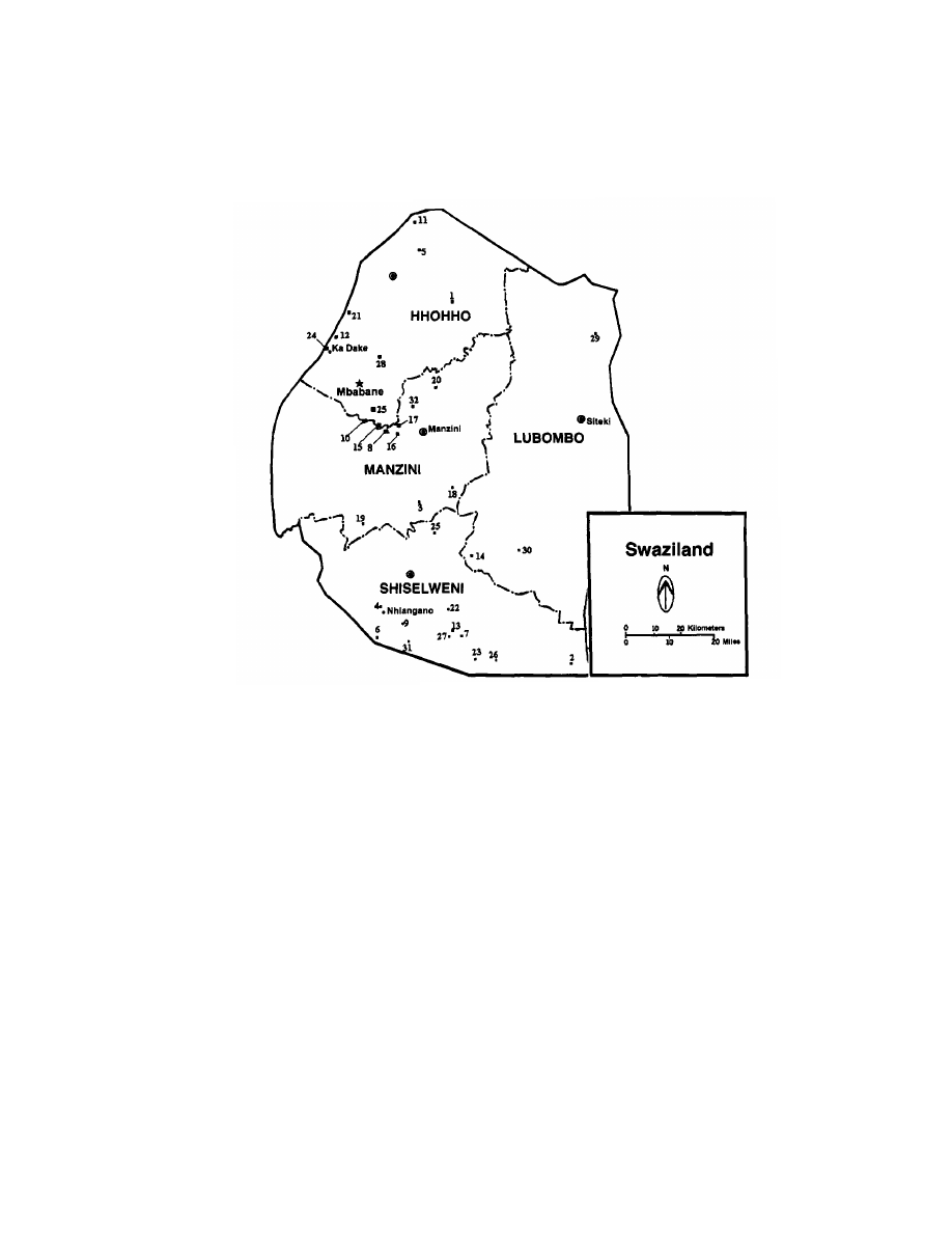
54
Chapter 4
Figure 4.3. Map of Swaziland with sites used in the analyses.
zation and distribution of archaeological materials including settle-
ments, landscapes, and sites of varying size and function are related
to economic and political organization. It is in the investigation of
the archaeological data on variability, configuration, structure, and
content of historical sites that the documentary story of the Mfecane/
Difaqane with archaeological data is confronted.
Excavations
Two complementary survey procedures were employed: one to
sample materials at or near the present ground surface, the other to
explore more deeply for the presence of cultural material. The precise

Previous Archaeological Research
55
localities for excavation were chosen based on indications from aerial
photos, discussions with oral historians, and density of surface mate-
rials.
After identifying the location of the site, it was generally given a
minimum confirmed size. A fixed grid consisting of a number of
squares measured in meters was surveyed over the site. The exact
size depended on the site size. The squares were then subdivided into
one-meter squares, which made up the actual excavation units. The
site was mapped and walked over, and different artifact-class concen-
trations were marked with differently colored flags (red for iron-
related materials, white for ceramics, yellow for stone tools, etc.).
Only some kinds of artifact samples, such as all rim sherds, were
collected from the surface. The density of surface materials generally
determined excavation locations. The underlying assumption is that
surface-artifact densities are proportional to subsurface concentra-
tions. Royal site excavations, however, concentrated on the middens
at the upper ends of the sites where the homestead head resides,
because ethnohistory and the excavations at uMgungundlovu have
confirmed that such middens are more likely to yield richer archaeo-
logical materials (Hall and Mack 1983,174; Parkington and Cronin
1979). Thus the approximate loci of the central enclosures were
sought from the oral historians.
Three sites were excavated in one-meter-square shovel tests by
natural levels. The archaeological excavation procedures involved
establishing a grid for each site excavated. Features and test units
were then mapped in relation to fixed survey datum points. To control
vertical measurements, temporary datum points were arbitrarily
established near each excavation unit, with permanent structures
(Somhlolo’s rock at Lobamba Lomdzala; a tree at Shishelweni Nkundla,
etc.) selected as convenient reference points. Numbered east-west
lines and alphabetically marked north-south lines were placed 10
meters apart, and each intersection was marked by a wooden stake.
All measurements for plan views, profiles, and stratigraphy were
taken from hand-held, leveled lines attached to the temporary datum
point. The coordinates and elevations of all temporary datum points
were later surveyed in relation to the previously established site
datum.
Excavation units were consecutively numbered with Roman nu-
merals in each sample square. Stratigraphic level designations
marked by Arabic numerals were given to each stratum of each
excavation unit, and all measurements were metric. Four minimum
and maximum opening and closing depths were recorded in the field

56
Chapter 4
catalog for each unit. Soil samples were collected and labeled with the
appropriate catalog number. Our technique for collecting excavated
soil samples was to trowel 500-gram samples into plastic bags from
various levels. Stratigraphic profiles and plan views were consis-
tently drawn for all excavation units. Photographic documentation of
the field work included 35-millimeter black and white print, color,
and infrared slide film. All formal photographic records of archaeo-
logical deposits included a metric scale and north arrow.
All soil deposits were first screened through 13-millimeter (½-
inch) mesh and again through 7 millimeter (¼-inch) screen mesh to
secure the recovery of small items such as botanical remains, beads,
and bones too small for the larger mesh. Our excavation deposits did
not exceed 70 centimeters and had a mean of 49.5 centimeters depth
of deposits, which is more or less typical for post-fifteenth-century
sites in southern Africa (Mason 1975). All cultural material retained
in the field was placed in labeled paper and plastic bags and trans-
ported to the National Museum’s laboratory in Lobamba, Swaziland,
for sorting, washing, labeling, storage, and analysis. Bag labels in-
cluded provenance information as recorded in the project catalog.
Excavation was done by two teams of two people each when
possible, composed of the permanent members, myself, Dunsani Set-
hebe, and whomever we could recruit. After the first month, Musi
Khumalo and some Swazi and U.S. students were also involved. Dr. T.
N. Huffman of the Department of Archaeology at the Witwatersrand
University also took part and provided much valued and appreciated
assistance in terms of time, labor, companionship, and expertise as
well as access to collections at his archaeology laboratory at Wit-
watersrand University in Johannesburg. Archaeological collections
were obtained from the 19 sites located along with other available
“Iron Age” sites sampled earlier for comparison. Initial excavations
revealed general locations of high artifact density and others where
little or nothing was found. Further site survey and more extensive
excavation is required for these sites to be studied to their full potential.
The Sites
Many Swazi sites, and all Swazi royal residences (umuti wenkosi),
have more than one name, not unlike Swazi kings’ names. They are
often alluded to by an official designation and locally by another term.
Royal capital names are repeated in an irregular rotation serving to
symbolically link them to the past (Kuper 1986, 9). Each new royal
residence is inaugurated by a new king and is correlated with his

Previous Archaeological Research
57
name(s) (Kuper 1947, 72). After the king’s death, the ancient royal
capitals are “kept awake” by successors who send royal wives to rule
under the care of the Ndovulakazi until the new heir and his mother
take control.
S151
S151 eShishelweni Nkhundla (the old scene or field of action
[Rycroft 1982, 51]), Esikoteni (a branch of the Ndwandwe clan), or
Emlotheni (“at the ashes”) is a late-eighteenth/early-nineteenth-
century royal capital and the ancestral home of the Swazi nation. It
is located in the middle veld in an area with fertile land, a low
incidence of drought, and access to year-round grazing. Bonner (1983,
14) suggests that this represents a greater concern with grazing and
hence the importance of cattle in the early Ngwane/Swazi economy.
Oral accounts suggest that this royal residence was first occupied
by King Ndvungunye (reigned 1790), who established his first Lilawu
at Shishelweni (Matsebula 1980,13). King Sobhuza I (reigned 1815)
also lived there before he and the “true Swazi” fled northward from
the Ndwandwe, who are said to have sacked the site (ca. 1817). Most
of the Ngwane/Swazi population remained behind as subjects of the
Ndwandwe; still others under Maitawane moved into the western
Transvaal. Thus, Shishelweni was probably occupied by “true Swazi”
between 1790 and 1815, a period of 25 years, its later occupation
coincident with the so-called Mfecane/Difaqane.
H. Kuper (1947, 12; 1986, 12) notes that her cultural experts
informed her that huge quantities of ash were seen at the site when
the Swazi arrived, suggesting previous inhabitants or sacking. Kuper
fails to indicate the reigning king at the time of the Swazi arrival.
This could have profound implications for Swazi historical accounts
and for the position offered here: If Shishelweni was sacked before
the arrival of the Ngwane/Swazi, then who had been occupying the
area? Were the attackers Ndwandwe, Boer, or even Griqua slave
raiders from the Cape periphery or perhaps British “frontier ruffians”
from Natal? Both Griqua and “frontier ruffians” are known to have
been operating at that time (Cobbing 1988).
Test square I was located approximately 30 meters up-slope
northeast of the central enclosure at the location of the heaviest
concentration of pottery encountered during the surface survey and
was opened to a depth of 48 centimeters. This area contained a tree,
which is not uncommon ethnographically; important meetings and
courts were held there.

58
Chapter 4
There were three animal burrows in the west wall and one in the
north wall of Test square I, indicating disturbance by ant-bear (Oryc-
teropus afer). Despite this, Test square I deposits were treated as a
single component because the site probably represents a single occu-
pation by one group for less than a generation.
The excavations recovered a lot of typical post-fifieenth-century
ceramics, one piece of which had applied bosses like those found in
Zululand at Elangeni (1750s), a KwaButhelezi settlement (Hall and
Mack 1983, 180), and Nqabeni (1700s), a KwaKhumalo “Type B”
stone-walled settlement, which had three such pots (Hall and Maggs
1979,168).
Many diagnostic bovid (cattle) bones, 35 percent of which were
burnt, were recovered in all levels, with heavier concentrations in the
upper levels
(42
cm). Caprine bones (sheep/goat), some of which were
burnt, were recovered from Level 3. Dense burnt dung occurred
throughout Level
2,
ranging between 3 and 5 centimeters on all walls.
There were three red glass beads ranging between
2.5
to 5 millimeter
diameter, two hematite nodules, a tubular bone bead (ear plug?), and
a round shale object in the top
42
centimeters as well.
Test square II was opened about 30 meters down-slope, south-
east of the enclosure and about 80 meters southeast of Test square
I. It revealed some post-fifteenth-century pottery in Levels 1 and 3.
The rim-to-body sherd ratio was .20, with 38 rims to 187 body sherds.
Some diagnostic cattle bone, about 85 percent burnt, came from Level
1; Level 3 contained diagnostic goat/sheep bone, about
40
percent of
which was burnt. One green chalky ocher piece from Level
2,
two
quartz cylindrical points from Levels 1 and 2, respectively, and one
quartz object from Level 3 were also found. What appears to be a daga
(hardened manure) floor lens was detected running for about
40
centimeters along the east wall in Level 2.
Botanical specimens associated with disturbed soils were re-
trieved from several locations (Chippindale 1979,
604):
Sporobolus
pyramidalis (umSingizane) from inside the central enclosure; Gra-
minae cynodon dactylon (isiFulwane) from the furrow where Test
square I was opened; and from outside the furrow, Fabancae rotalaria
(catstail grass) and S. pyramidalis.
SI48
Lobamba Lomdzala (old Lobamba), Kalangabane, or Entshakabili
(burnt twice by Shaka) was a Lilawu built by Sobhuza I (born 1800,
ruled 1815-1838, died 1839) ca.
1820
after leaving eShishelweni (Mat-

Previous Archaeological Research
59.
sebula 1980, 17; Perry 1987). Bonner (1983, 24-34) argues that
Sobhuza I’s flight from eShishelweni and his resettlement at S148
were more like a military occupation in Sotho territory than a settled
administration. It was still functioning during the reign of Mswati
II in 1852 under the name of Ekufiyeni (Bonner 1983,118; Honey 1915,
32; Matsebula 1980,381. Thus Lobamba Lomdzala was probably oc-
cupied from 1820 to at least 1852, a total of 32 years.
S148 is located near Nokwane Hill in the Lusushwana River
Valley in the transitional zone of the middle veld, with access to
excellent cattle-grazing land, as well as fertile agricultural soils. Oral
accounts attest to its location as an excellent vantage point from
which to view the surrounding valley and hence enemy advances.
Test square I was placed at the northern limits of the site survey
area at the approximate position of the central enclosure, which also
contained a tree. Because the modern inhabitants along the road that
now divides the old enclosure from the more southerly up-slope dwell-
ings were reluctant to grant us permission, we surveyed only the
areas north of the road and neglected up-slope locations. Excavations
went to a depth of 46 centimeters but were sterile.
Test square II was placed at the locus of a heavy concentration of
surface ceramics approximately 7 meters northwest of Test square
I farther up-slope of the enclosure. A trench was sunk between
plowed contours to minimize any disturbances, to a depth of 60
centimeters. This square contained an abundance of post-fifteenth-
century ceramics in all levels. The square contained a rim-to-body
ratio of .36, with 43 rims to 121 body sherds. Two distinct pottery
concentrations were found in Level 2, one in the square’s center and
another in the northwest corner. The northwest corner collection
contained a larger pot with an upside-down smaller pot inside
1
and
1
At S134 Siphiso Cave in Swaziland at a depth of 35 centimeters, two brewing pots
(eMadziwi) were recovered upside down, one inside the other; the outer pot resembles
U-shaped bowls from Mabhija (1690-1885) in Zululand (Maggs 1982). The measure-
ments of the Swaziland pots fit into the range of Hall’s (1981) Zulu pot rim diameters
for open-mouth bowls. This is a common occurrence in western Africa according to A.
Stahl (personal communication, 1992). Huffman (1972, 68) in describing Shona ce-
ramic production, notes: “A small hole is dug about 60 to 90 cm deep and the pots
placed on top of each other, mouth down.” Klapwijk (1989) describes Transvaal royal
pot burials in which a large pot containing human remains is sealed by a smaller one
placed inside the larger one, but these pots are not inverted. S. Azizi (personal
communication, 1989) has suggested to me that pots inside each other may reflect
the potters’ use of old bases in the production process, and bases may be in the spot
where pots are being manufactured, accounting for the lack of bases in archaeological
assemblages in southern Africa.

60
Chapter 4
was overlaid by a 3-centimeters-thick lense of burnt cattle dung. This
concentration was not treated as a feature because an undetermined
portion remained inside the wall and rendered the boundaries indis-
tinct. The finds, however, were separately bagged, with the general
limits sketched onto the plan view.
Some rodent bones were recovered from all levels along with
many diagnostic cattle remains, some of which were burnt. Diagnos-
tic sheep/goat bones, none of which were burnt, were restricted to
Level 4, suggesting that they could have been part of a pit fill.
Lithics found at the site included hammer stones, pottery rubbing/
smoothing stones, circular grinding stones, one stone scraper, some
quartz fragments, and a scratching stone, underneath the silicified
dung concentrations in the northwest corner. Glass beads in a variety
of colors were found at all levels, with diameters between 2.5 to 5
millimeters. Level 1 contained two (green and aqua); Level 2 had two
white/ivory; Level 3 had eleven beads (red, ivory, gray, white, blue/
green, brown, and yellowish with red edges and black spots), while
Level 4 had one white bead. There were several iron objects: a nail 6.4
centimeters long and 4 millimeters wide, closely resembling heavy-
duty square-cut nails used in heavy construction, recovered from
historical archaeological sites in the United States (Schuyler and
Mills 1976, 74);
2
an iron ring (3.5 cm diameter) or perhaps a child's
bangle or band, and another iron object in Level 1; and a long (17.5 cm)
pointed implement (an iron awl?) that resembles a photograph of a
spike spearhead from the Dargle hoard (Maggs 1991,133, Fig. 5, #11)
and a spike from Rongpoort (Maggs 1991,133, Fig. 6, #5) in Zululand
in Level 3 along with a possible bone ring. Ostrich eggshell pieces
were also found in Levels 3 and 4. We also uncovered what appeared
to be another daga dwelling-floor lens, approximately 12 by 8 centi-
meters, in the southeast portion of the square coming out of the south
wall at the base of Stratum two, which began a “clean” interface at
Level 3.
There were some botanical specimens reflective of human dis-
turbance at the site: Rhynchelytrum repens in the ploughed fields and
Sporobolus pyramidalis (umSingizane) outside the cattle enclosure.
2
There are many ethnohistorical accounts describing the procurement and use of
nails from European vessels. For example, historic sources allude to the fact that Cape
Nguni would burn shipwrecks to obtain nails: “[T]he Mpondo take masts and remove
the iron to make assaygies and lances” (Carter 1782,6, in Shaw and Van Warmelo
1974,107). In addition, iron nails were sometimes used in local exchange networks
and were often reworked into objects with new functional uses.

Previous Archaeological Research
61
S149/S22
The last site excavated was S149, Kadake stone-walled BaSotho
ruins (Londozi site [Price-Williams 19801) occupied around the eigh-
teenth and nineteenth centuries in the highveld just west of the
Londozi River. This excavation is important because it is not a royal
Swazi residence, but rather an Emakhandzambili (“those found
ahead”) settlement.
Cultural experts and oral historians from the Magagula clan, one
of the major Sotho clans in the area of S149, were interviewed and
consulted about the ruins. Their direct ancestors were in north-
western Swaziland when the Ngwane/Swazi arrived. Oral traditions
suggest the Kadake settlements were occupied during the reigns of
Mswati (ruled 1839) and Mbandzeni (ruled 1875) and thus occupied
for at least 36 years (Perry 1987). With the rise of the Swazi state,
the Swazi king displaced the Sotho ritual power to become the su-
preme rainmaker for the nation.
Swaziland’s northwestern highveld contains hundreds of stone-
walled settlements located on the slopes of V-shaped valleys. These
sites extend into the southeastern Transvaal and are clearly visible
on 1:30,000 winter aerial photographs. From such photographs, an
area was selected for survey and excavation near the Mzima home-
stead where excavation materials could be stored because the site
was 10 kilometers from the road and in very mountainous terrain.
The survey area contained a series of stone-walled circular struc-
tures constructed from locally available talc schists and linked with
more stone walling to form curvilinear enclosures and horizontal
terraces with livestock tracts, similar to those found throughout the
eastern Transvaal highveld (Evers 1975; Mason 1968). Many of the
sites contained stone mounds, probably from field clearance (Price-
Williams 1980).
I found three basic types and dimensions of stone-walled settle-
ments at Kadake, all with down-slope-facing entrances:
A. Primary enclosures linked with secondary walling to another
enclosure, ranging in size between 2 to 3 meters in diameter.
B. Individual enclosures between 5 to 6 meters in diameter.
C. Primary enclosures sharing walling. This type was the most
abundant and showed the most variability in size and pat-
tern. The central enclosures range from 8 to 10 meters in
diameter, and the adjoining enclosures range from 1 to 4
meters in diameter.

62
Chapter 4
The largest type relatively near the Nzima homestead was cho-
sen for clearance and excavation. In addition, nearby were some
early-twentieth-century European industrial structures we were
also investigating. This steep hill slope had three other Type C struc-
tures and some Type A and B structures as well. The Type C struc-
tures’ walls were generally 1 meter high and 1 meter across at their
top, similar to stone-wall dimensions at Nqabeni in Zululand (Hall
and Maggs 1979; Hall 1984c, 70).
Two test squares were selected based on Sotho archaeology in the
Transvaal and suggestions of the Sotho cultural experts. Test square
II was a “garbage dump” area at the northern end of the site, vir-
tually sterile and filled with rubble to a depth of 60 centimeters.
Test square I was a “kitchen” area at the southern portion of the
site about 50 meters down-slope southeast of Test square 11, also
containing a lot of stone rubble. It was opened to 86 centimeters and
produced three plain black-body sherds typical of post-fifteenth-
century ceramics and sheep/goat remains from Level 1, some of
which were burnt. Also retrieved from Level 1 were lithics, including
a hammer stone, a cylindrical quartz tool point, a soapstone object
with a circular central depression, and several soapstone cobbles in
Levels 1 and 2. Several pieces of red ochre and ostrich eggshell pieces
were found in Level 1. Burnt wood fragments were recovered in both
levels and were probably used for cooking and heat during the cold
nights in the highveld. Samples of the wood were collected and taken
to the National Herbarium in Molkerns, Swaziland, to be identified
as to genus and species as well as to be dated by carbon-14 techniques.
These results must await future funding.
According to Feely (1985), some Acacia species are associated
with early village sites in the Transvaal, but he does not specify which
species these are. There were several Acacia species present at Ka-
dake. Acacia divinorum (umGwali) and Acacia karroo (isinga) were
located outside the stone walls. Rutaceae Zanthoxylum capense (um-
Nungwane), a citrus tree thought to be associated with iron smelting
when found in atypical locations (Feely 1985, 10), was found outside
the stone walls as well.
S158
S158 KaHhohho I or Ezibondeni (wall/dip/valley in mountains)
or Hlobane was the Lilawu of either Ngwane II (1695-1755) or III
(1750-80)(died 1780) (Bonner 1983, 14; Matsebula 1980, 12; Perry

Previous Archaeological Research
63
1987) or Ndvungunye (ruled 1790), Dlamini III (1680-1730), and
Sobhuza I (ruled 1815, died 1839) (Perry 1987). It is located in the
southern middleveld, and it too has access to different veld types on
the Ngwede River near Mlosheni in a valley surrounded by several
mountains.
The oral histones and the surface collection indicated the site’s
importance, and it was scheduled for excavation, but an auger test
showed bedrock at 25 to 35 centimeter depths coupled with a less
than enthusiastic response to excavation by the local populace, whose
homesteads were located on the site itself. Therefore, we canceled the
excavations. The site was surveyed and mapped, and an intensive
surface survey was conducted.
The surface survey revealed a massive area of burnt cattle dung
exposed by erosion, which did not appear to be continuous, along the
truck road that runs directly through the site. Surface ceramics
consisted of 1 rim and 30 body sherds, all undecorated, a rim-to-body
ratio of .03. Various lithics including a large (17 cm) scratching stone,
several hammer stones, and some quartz pieces were collected from
the surface. A remarkable iron hoe 23 centimeters long and an iron
leg from a pot, along with diagnostic cattle bones, were also retrieved.
Botanical specimens collected were from none of the known types
that suggest human activity or disturbed soil.
ARTIFACT PROCESSING AND ANALYSIS
All recovered specimens from the 19 surveyed sites including the
3 excavated sites were processed, analyzed, and curated at the Na-
tional Museum laboratory, Lobamba, Swaziland, in 1987, and in the
City University of New York Graduate Center archaeology laboratory
in New York City from 1988 to 1992. All artifacts were cleaned,
cataloged, labeled, and inventoried, to be eventually placed in a com-
puter database before returning them to the National Museum in
Swaziland. Materials were sorted into the following classes.
Ostrich Eggshell
Ostrich eggshell is found fairly often on African archaeological
sites, where it is usually taken as evidence of Ju/’hoansi pastro-
foragers. One piece was found at S148.

64
Chapter 4
Pigments
Hematite ironstone specularite has been exploited in Swaziland
for body decoration since AD 400 at Ngwenya. Among southern Afri-
cans, pigments have special ritual, spiritual, and medicinal signifi-
cance, especially when used by both Swazi (iZangoma “blood of the
earth”) and Zulu (Inyanga) healers, who use pigments on dead bodies
and bones (Mbatha 1960,92). Pigments also serve a variety of other
functions such as decorative material for making cosmetics, decorat-
ing ceramics and clothing, coloring and closing the pores of blankets
to maintain warmth and repel vermin, and coloring and dyeing other
objects (Shaw and Van Warmelo 1974, 202).
Hematite nodules were present only at the excavated sites S151,
a royal residence, and S149, a commoner residence. They were not
encountered in any of the surface surveys.
Burnt Dung
Burnt dung, sometimes referred to as vitrified or silicified dung,
is cattle manure that was burned as fuel. It can be identified by fired
soil nodules in a midden with a more granulated texture than “regu-
lar” ash (Huffman personal communication, 1987). Denbow and
Wilmsen (1983) have used dung deposit depths to indicate herd and
site size and site duration and to classify settlements in Botswana.
In Swaziland, we found several such burnt dung concentrations
but none as deep or wide as those found in Botswana. This situation
suggests smaller sites with shorter occupations in Swaziland, which
supports the oral texts. For example, the largest area of burnt dung
is found at S158, and is 30 to 40 meters wide, and extends to a depth of
25 to 35 centimeters. These dimensions fall within the small site size
and short duration for Botswana sites.
Ceramics
Although some Swazi cooking and drinking vessels had geomet-
ric designs during the 1940s and even today, (Kuper 1986,49) in post-
fifteenth-century archaeological collections throughout southeast Af-
rica, undecorated, utilitarian ceramics predominate (Hall 1981; Hall
and Mack 1983; Hall and Maggs 1979; Maggs 1971). Post-fifteenth-
century Swaziland ceramics are generally thin, undecorated graph-
ite wares. They are usually black, gray, dark red, or buff with black

Previous Archaeological
Research
6
5
mottling. When present, surface decoration consists of incising, bur-
nishing, some applied bosses (small pieces of clay in a sequence), red
hematite painting, and black graphite coloring (Sonkayane personal
communication, 1987; Khumalo personal communication, 1987).
In Swazi society, women potters produce coiled ceramic vessels.
The clay is collected from stream bed deposits, sun dried, and crushed
to remove impurities. The walls of the pots are smoothed with a stone
and placed outside to dry. Pots are then fired in a grass-covered pit
along with slow-burning wood.
The most common ceramic vessels in modern Swaziland are the
U-shaped open bowls and pots for cooking, water/beer serving, and
group drinking and the smaller pots and larger beer-fermenting and
-brewing pots.
Few post-fifteenth-century sherds from the Swaziland excava-
tions have been large enough to permit the reconstruction of vessel
size and shape profiles or formal metric analysis based on different
characteristics of technology and vessel form and function. Further-
more, because the overwhelming majority are undecorated, stylistic
analysis is largely precluded. Those sherds that are large enough,
along with some almost complete vessels, tentatively indicate that
utilitarian wares for personal household cooking/serving/eating dom-
inate the Swaziland assemblages.
The sites containing pottery had a combined rim-to-body sherd
ratio of .25, with 109 rims to 431 body pieces. Most sherds are plain,
thin (less than 7 mm), smooth in texture and temper, burnished with
red ochre or graphite, and well fired. There are only two decorated
sherds, one from S151, which had applied bosses below the rim, and a
surface rim sherd collected from S156 Mbekelweni, a late-nineteenth-
century royal residence of Mbandzeni (ruled 1875). This sherd is
buff with an impressed single horizontal groove parallel to the rim,
with oblique hatching or comb stamping on the rim, similar to a motif
found on pottery from the Eiland salt factory, a pre-fifteenth-century
site in the Transvaal (Evers 1979, 98).
Metal Objects
Both oral and written texts claim a long, prestigious tradition
in the eastern Transvaal, Natal, and Swaziland for iron specialists
until their subordinate incorporation into military polities during the
Mfecane/Difaqane.

66
Chapter 4
In Swaziland, certain hereditary clans, Inyanga yokukhandza
insimbi (skilled ironworkers), had ritual power; they were held in
high esteem and exchanged iron goods for cattle. Oral texts suggest
that some of Shaka’s iron blades were made in southern Swaziland
by the Gwebu (“scum/froth of beer”), the Shiba (“add condiments to
food”), and the Mkhonta (“those who seek asylum”) (Induna Khumalo
in Perry 1982, Tape B2,50; Price-Williams personal communication,
1985).
With the consolidation of the Swazi state during the mid-nineteenth
century, these clans were held in low esteem and not allowed to
accumulate wealth or prestige. Forced to live on the periphery of the
kingdom, they took on low-status ethnic designations (Bonner 1983;
Perry 1991,4). Archaeological excavations in Zululand indicate that
some of these specialists did live at military capitals (Parkington
and Cronin 1979; Plug and Roodt 1990).
Kuper (1947,143) notes that iron is not buried with individuals
in Swaziland but is curated and that the forge is located away from
the homestead and agricultural fields as is also the case among the
eastern Transvaal Sotho (Evers 1975,761, the Cape Nguni (Shaw and
Van Warmelo 1974), and the Zulu (Maggs 1980). The abundance of
iron-smelting sites throughout the northern Mkhondvo Valley, in
the Komati Valley, and in the Nottingham Hill areas above the
Mkhomozane River attest to the importance of iron production in
Swaziland. These sites are generally located near the lowveld where
iron ore deposits and ample slow-burning tree species occur (Sithebe
in Perry, 1987). The few dated furnace sites are all pre-fifteenth
century (Price-Williams 1980; Beaumont 1972).
The iron-production process in Swaziland uses either subterra-
nean bowl furnaces or elliptical furnaces with goatskin bellows that
direct air through the tuyeres (fired clay blowpipes modeled onto the
sides of the furnace) into the furnace, while the smelted iron runs
into clay receptacles (Kuper 1947). Iron hammers and large anvil
stones were used to complete the shaping of implements. There are
several botanical species associated with iron-smelting sites in south-
ern Africa: Combreturn imberbe at Phalaborwa (Van der Merwe and
Scully 1971); Euclea divinorum at Hluhluwe (Hall 1980); Combretum
apiculatum, C. imberbe and Terminalea sericea at Square (Van der
Merwe and Killick 1979,63); andAccacia caffra,A. ataxacantha, and
A. burkei at Mahbija (Maggs 1982, 140).
Many of the Swaziland sites investigated contained metal ob-
jects, and an iron-working site and three iron furnaces were located

Previous Archaeological Research
67
during the survey. S160 site located near Inhlanhle Mountain just
east of the Kahhohho I site contained an elliptical furnace eroding
onto the road surface and another furnace in very poor condition on
the western edge of the road. Both were considerably flattened by
motor vehicle traffic. The most complete one was 40 centimeters wide
by 76 centimeters long and resembles furnaces from the east unit at
Hluhluwe (1680-1850) in form and dimensions (see Hall 1980). S161
Sitobela is a badly preserved furnace eroding out of a donga located
near the Mhlayhuzane River.
The Maghebukeleni site (S152) is located about 5 kilometers
southwest of Mashila, a pre-fifteenth-century iron furnace in the
Mkhondvo River Valley, an area inhabited by the KwaGwebu who are
renowned ironworkers in Swaziland. This site consists of a circular
clearing with a diameter of 24 meters, with an opening facing east-
ward about 50 meters downward into a large donga gully. This donga
contained large amounts of surface iron cinder slag (a waste product
of iron working) with visible charcoal nodules and bloom (a spongy
iron semisolid mixed with slag, charcoal, and other debris) piles, post-
fifteenth-century body sherds, stone tools, and a few dimple-faced
hammer stones presumably for crushing ore and iron slag.
None of the botanical specimens collected from these sites was a
known species associated with iron smelting or atypical of the envi-
ronment, or a slow-burning species, or diagnostic of human activity.
Faunal Material
The faunal material from the excavations was tentatively identi-
fied by Dr. T. N. Huffman, myself and Musi Khumalo. It was classified
by animal species, diagnostic and undiagnostic bone, and burnt and
unburnt bone. Animal bone was present at all excavated sites, and
most of it was burnt. Most surveyed sites turned up faunal remains,
but none of it was burnt.
There did not appear to be any wild animals suggestive of local
hunting or trapping. Excavated assemblages seemed to be dominated
by bovids (cattle), about 35 percent of which were burnt, at all levels
except for the faunal remains from S149 the BaSotho site, which
yielded only ovicaprids (sheep/goat), 40 percent of which were charred.
If this pattern is a general one, it can support oral histories
that suggest that only the aristocrats possessed cattle and that sheep
were taboo to all members of the royal Dlamini clan (Kuper 1947,45).
This pattern may also indicate environmental constraints because

68
Chapter 4
the highveld is not conducive to cattle herding but is good for sheep
and goats. It may also mean that elite Sotho lived elsewhere, closer to
the middleveld with their cattle. The Sotho oral historian proudly
informed me that “many imfukwana (the sacred royal herd of the
Swazi king) were taken by the Swazi king from the Sotho of Kadake”
(Magagula 1987, in Perry 1987, tape B3).
Beads
The primary use of beads and beadwork is ornamentation and
decoration of men, women, and material objects. Beadwork and bead
production are female crafts in southeast African society (Mbatha
1960,99).
By the early nineteenth century, beads figured prominently in
African social relations: Cattle could be purchased with them (Shaw
and Van Warmelo 1974,199); they formed part of marriage payments
and regulated the love life of unmarried men and women; they indi-
cated specific social, ritual and gender statuses; and they functioned
in the installation ceremonies of political personnel.
Beads have played an important part in both inter-African and
African-European trade. Southeast African sites yield beads pro-
duced from a variety of materials such as brass, iron, copper, clay,
bone, and glass. Beads are also produced from perishable materials
like seeds, leaves, wood, and other plant material with aromatic
properties.
Archaeological evidence of bead manufacturing in southeast Af-
rica comes from the sites of Harmony (1680-1820s) in the eastern
Transvaal, which mass-produced beads of copper, bone, clay, and
glass, and unMgungunglovu (1828) in Zululand, which produced cop-
per, clay, and brass beads made from brass wire imported from De-
lagoa Bay (Parkington and Cronin 1979).
Glass beads are by far the most numerous type recovered and
because they are imported, have aided archaeologists by providing a
relative dating technique (Davidson and Clark 1976). For example,
royal blue translucent hexagonal and round beads are the most
common and well-known nineteenth-century beads recovered in
southern African sites (Evers 1974, 35). Their popularity and value,
however, have resulted in their curation by many African groups.
These prized heirloom beads complicate the chronology somewhat
and result in greater diversity in archaeological collections (Evers 1979).

Previous Archaeological Research
69
Glass beads themselves have been remanufactured in an African
context. For instance, neutron activation analyses of garden roller
beads and certain other blue-green beads from Bambandyanalo (K2)
and Mapungubwe in Zimbabwe indicate that garden roller beads
were made by reworking the blue-green beads (Davidson and Clark
1976,17). They were transported on large strings to regional elites for
dissemination to local elite for regional networks (Fagan 1969, 11;
Shaw and Van Warmelo 1974).
Imported glass beads, especially the large dark blue cane beads,
came into southeast Africa from India up until 1660, after which they
came from Europe (Shaw and Van Warmelo 1974, 198). The Portu-
guese plunder of the East African coast devalued copper, destroying
the local copper industry in the eastern Transvaal, and glass beads
replaced copper as the internal exchange medium in small trans-
actions in the Delagoa Bay-Natalregion (Slater 1976, 152).
Our Swaziland excavations turned up 3 small red glass beads
from S151 and a tubular bone bead. Red beads were highly coveted
and used in local exchange networks by sixteenth- and seventeenth-
century southern Africans (Lee 1979, 78; Shaw and Van Warmelo
1974,191; Wilmsen 1983). There were also 12 small beads from S148,
all with diameters between 2.5 to 5 millimeters by 1, smaller than
Evers’s (1982) beads from Lydenberg but within the range of those
recovered by Evers (1979, 104) and Chatterton, Collett, and Swan
(1979, 117) at Harmony.
Lithics
Stonework was performed principally by men, but lithics were
used by both men and women for a variety of purposes in southeast
Africa. The more general purposes might include grinding stones
(muti) with an understone for grinding maize, pigments, snuff, and
plant materials; hammer stones; bored stones with a central round
hole used as digging-stick weights; stone for sharpening metal tools;
stone axes for felling trees; house foundation stones and those used
to construct houses, steps, cattle enclosures, and stock tracts; hearth-
stones; fall-trap parts; anvils for ironworking; and flat stones used for
grain-pit covers. The Swazi and eastern Transvaal Sotho also used
rounded stones for burial markers for nonroyal graves.
Our surface survey collections recovered many of the above types
of lithics such as dimple-based hammer stones, lower grinding stones
with broader, more circular hollows emblematic of later periods

70
Chapter 4
(Maggs 1980, 11-12), and modified chipped stone pieces and frag-
ments suggesting maize and pigment production, indicating that
these sites were used on a more permanent basis. Huffman (personal
communication, 1985) suggests that grindstones and multifractured
hand stones are reflective of specialized maize preparation in the
highveld before 1750.
Our excavations revealed pottery rubbing stones and “scratch-
ing” stones that were identified with the aid of Swazi cultural experts.
At S149, there were soapstone cobbles and soapstone objects with
circular central depressions that could have been unfinished or
flawed soapstone bowls used in salt production (Evers 1979).
S148 and S151, both royal residences, contained some cylindrical
quartz points/objects whose function is unknown. There were abun-
dant quartz pieces found at S150 Nsalitje cave, which according to
local Swazi was a known quartz production site in the recent past.
Posnansky (in press) mentions “Ghana strike-a-lights,” which are
produced from unmodified chunks of quartz and are part of the
western African tradition of recycling raw materials. Unfortunately,
no illustrations or measurements are given for comparison with the
Swazi quartz objects.
Similar quartz crystals have been found in eighteenth- and
nineteenth-century African-American captive cabins on plantation
sites in the south often as part of a cache of other objects. Such objects
have also been found grouped and displayed in front of hearths,
outside entryways, and in the northeast corners of rooms where
African captives lived and worked in the “urban” north (Singleton
1995,131; Singleton and Bograd 1996, 23). We have recovered some
quartz crystals apparently associated with burials both from inside
the graves and from what may be from the grave surface, at the
eighteenth-century African burial ground in New York City (Perry
1996b, 1997a, 1997b). In BaKongo and African-American burials,
surface decorative objects frequently function as sacred “medicines”
of admonishment and love, to honor the spirit in the earth, guide it to
the other world, and prevent it from wandering or returning to haunt
survivors (Thompson 1983, 132). Thus these spiritually powerful
objects have been linked to an African religious tradition of manag-
ing the spirit world, through a divination system called minkisi
(plural-
nkisi = “singular”) practiced in West and Central Africa and
throughout the African diaspora. Minkisi is believed to be used in
curing and conjuring rites to predict the future, help heal the sick,
and protect the house and its inhabitants (Thompson 1983).

Previous Archaeological Research
71
S150 Nsalitje cave in the southeastern lowveld was brought to
my attention by some local Swazi, who informed me that it was an
ancient coal mine in use since the 1880s and still used by Swazi to
mine coal. The Swaziland Department of Mines identified the coal
samples as anthracite, which Swazi prefer because it is smokeless
and leaves little ash (Bowen 1978,78). There were undecorated body
sherds, stone tools, and many quartz pieces collected on the site
surface. On the other side of the hill from S150, we located an area
about 100 square meters, which appeared to be a modern quartz
production center with approximately 7 to 10 huge piles of quartz
nodules (Perry 1987).
SUMMARY
The Swaziland research suggests that events and place names
associated with the later sequences from the oral traditions and the
genealogical lists reveal important details about Swazi society in
general and the rise of the Swazi state in particular. Discrepancies
in the various accounts seem to suggest that disputes over succession
had earlier precedents that continue today (Perry 1991). Some sites
with historical referents may, at least tentatively, be corroborated by
some archaeological evidence. The oral texts suggest that enshakabili
(burnt twice by Shaka) and Eshishelweni (the place of burning/the
hot country) were sacked. Test excavations at these sites have yielded
large quantities of burnt bone, soil, and dung. On the other hand,
burnt materials in central enclosures likely indicate residue from
elite families using the court (Huffman 1984, 4).
This evidence could also represent areas for pottery firing, court
fires, or samples of large ash middens, located between agricultural
fields and the main entrance to the cattle enclosure, which cattle were
herded through on their way to the enclosures so that ash adhering to
their legs would reduce infestation of ticks and other pests (Hall 1981;
Huffman 1984,1986). There was no evidence at either site for dung
removal evidenced by lowering of enclosure floors, and charcoal
lenses suggesting that trees were available for fuel were found.
One major problem with my Swaziland research is the bias
toward elite and politically powerful areas. More survey is needed
away from political centers to better indicate how state formation
affected the social organization and dynamics of nonelite households.
Such studies can also help us better understand the history of modern

72
Chapter 4
political dynamics in Swaziland. Another limitation is the small
number of sites excavated and the small scale of the excavations
themselves. On the other hand, given the virtual absence of any post-
fifteenth-century archaeology in Swaziland itself, this research rep-
resents a beginning.
It is clear that archaeology is a valuable and necessary adjunct
to oral and documentary research in establishing a diachronic frame-
work to study historical processes. With the development of more
sophisticated methodologies of interpretation of oral texts coupled
with an archaeology informed by such traditions, expectable results
can contribute to southern African archaeology by complementing
and improving understandings based on the historical record.
To address the questions that I have proposed in this book re-
quires combining the Swaziland research with other post-fifteenth-
century research in southern Africa. It is to this synthesis and anal-
ysis that I now turn.
COMBINING THE SWAZI AND OTHER SURVEYS:
ARCHAEOLOGICAL RESULTS
Chronological Limitations
Historical archaeology in southern Africa is fraught with prob-
lems when we seek to fine-tune chronometric dating of historical
periods. Fluctuations in atmospheric radiocarbon during these pe-
riods coupled with broad ranges of standard deviations preclude
precise dating of archaeological materials. Recent research on car-
bon-14 dating resulting in the Struiver and Becker calibration curve
has shown that calibration works globally; region-specific calibration
curves are not needed (Stuiver and Pearson 1986). Nonetheless, sev-
eral carbon-14 calibration curves for southern Africa have been de-
vised, and there are a number of chronologies for southern African
sites (Hall and Vogel 1980; Maggs 1977; Maggs and Whitelaw 1991;
Parkington and Hall 1987). In the current absence of any other choice,
I have accepted these dates on face value and have given the time
range of the probability values of their standard deviations.
There are other useful methods of dating the later historical
periods in southern Africa. For example, archaeomagnetism has been
successfully used by Henthorn, Parkington, and Reid (1979) to date
African iron furnaces at uMgungundlovu. The analysis of datable

Previous Archaeological Research
73
imports such as European glass beads has also been used (Van der
Merve and Scully 1971; Davidson and Clark 1976).
A number of useful chronological typologies developed for stone-
walled enclosures and structures in southern Africa have been uti-
lized (cf. Collett 1982a, 1982b; Hall 1981; Jones 1978; Maggs 1976a,
1976b; Mason 1973). For example, Type B settlement units, which are
assumed to date from the sixteenth through early nineteenth centu-
ries in Zululand, have been shown to be characterized by robbing.
Robbing is a relative dating technique developed by Maggs (1976a)
for southern highveld stone-walled sites, which involves considera-
tion of transport cost of new stone to build new settlement units. It
assumes stone construction of any particular period to be in a fairly
uniform state of preservation, with the amount of robbing increasing
with age. Well-preserved settlement units are assumed to be those
last abandoned.
Finally, oral traditions have proved invaluable for dating archae-
ological sites (e.g., Maggs 1976a, 1976b; Hall and Mack 1983; Van der
Merwe and Scully 1971; Wright and Kus 1979). As adjuncts to archae-
ological investigations, oral accounts can lend independent evidence
and testing and consequently have been used to date many sites in
this survey.
Often while reviewing the dating literature, I found that differ-
ent authors used different dates and failed to specify whether they
were referring to the entire site or to a particular component of the
same cultural landscape. In such cases, I have taken the extreme dates
to be ranges, and I assume that earlier landscapes with post-fifteenth-
century occupations represent a continuous historical process.
The resulting picture derived from the settlement descriptions
and surface collection materials for the post-fifteenth century obvi-
ously presents a problem for any tentative chronology based solely on
ceramic types. Therefore, more attention should be paid to spatial
significance. Consequently, in analyzing the data, an effort is made
to interpret these data as a reconstruction of historical interaction
affecting post-fifteenth-century spatial organization.
SUMMARY AND CONCLUSIONS
The southeast Africa survey area is bounded by the 22 degree
parallel of southern latitude (south of the Limpopo) and the 24 degree
meridian of southern longitude in the west. For purposes of analysis

74
Chapter 4
the eastern and western Transvaal was divided by the 29-degree
meridian of southern longitude. The entire area considered for anal-
ysis consists of 800,400 square kilometers (500,250 mi
2
). A total of
159 sites with known settlement sizes and/or calculable sizes was
constructed for the settlement typology.
The data used in the analyses were obtained from two basic
sources. The post-fifteenth-century materials and information re-
sulting from the Swaziland ethnohistorical research and archaeologi-
cal survey are one source. Nineteen sites located during the Swazi-
land survey are used in the analysis along with seventeen others from
the ethnohistorical and archaeological literature on Swaziland with
post-fifteenth-century components located in Swaziland for a total of
thirty-six sites representing 22 percent of the total sites.
The second data source is the published archaeological and
ethnohistorical literature on post-fifteenth-century southern Africa
outside Swaziland. The breakdown is as follows: 40 or 25 percent of
the sites are from Zululand; 4 or .02 percent are from southern
Mozambique; 36 or 22 percent are from the eastern Transvaal; 24 or
15 percent are from the western Transvaal; 16 or 10 percent are from
the Free State; 2 or .01 percent are from the Cape frontier; and 1 or
.006 percent is from the eastern Cape (Transkei), for a total of 123 or
77 percent of the post-fifteenth-century sites. Together, the Swazi-
land sites and the other southern African sites total 159 sites.
The variables have been abstracted for each of these sites where
available. The abstracted variables, sites, and site information from
the literature and from my Swaziland survey are available on tables
in six appendices in my doctoral dissertation (Perry 1996a, 348-479).
It remains to be considered how well the hypotheses generated
in Chapter 3 fit or are discordant with the actual archaeological data.
In Chapter 5, these archaeological projections are evaluated against
the archaeological record for southern Africa.

Using Archaeology
to Study the Processes
of the Mfecane/Difaqane
5
This chapter explores what archaeology has to contribute to the
discussions of the Mfecane/Difaqane. The main goal of this chapter is
to answer the question: “Is the standard Settler Model of the Mfecane/
Difaqane factually accurate?” To answer this question, I restate the
archaeological correlates generated from Chapter 3 and compare
them with the archaeological data from southeastern Africa.
The anthropological literature and the debates of historians sug-
gest that pre-Mfecane/Difaqane and Mfecane/Difaqane models should
have specific archaeological implications. These expectations derive
from three fundamental assumptions of the Settler Model: (1) the
existence of isolated ethnic groups with distinct architecture, mate-
rial culture, and geographical locations; (2) little social interaction
between these groups; (3) the idea that the Mfecane/Difaqane origi-
nated in the region that is today Zululand. In the Zulucentric focus,
three factors have been proposed to account for the Mfecane/Difaqane:
ecological change, external trade, and demographic change. I investi-
gate the data collected from archaeological contexts to see how they
can contribute to these issues.
If the standard Settler Model of Southeast African history is
correct, we can expect distinctive and different settlement pattern
location and hierarchy characteristics in the pre- and post-Mfecane/
Difaqane periods.
CONTRASTING THE SETTLER MODEL
WITH THE ARCHAEOLOGICAL RECORD
The Settler Model predicts that certain sites in different geo-
graphic regions will have particular architectural features and arti-
facts at specified dates. To see whether the archaeological record
supports these assumptions, I used mostly published and a few un-
75

76
Chapter 5
published sources from the archaeological literature of southeastern
Africa to generate an observed settlement typology.
OBSERVED SETTLEMENT TYPOLOGY
A settlement typology based on 14 functional classes identified by
the historical and archaeological data was generated for all sites
(Perry 1996a, 348-401).Unless there was evidence to the contrary, I
assumed that the post-fifteenth-century occupations of a particular
site covered the entire area of that site.
Several problems arose during the development of the settle-
ment typology. One problem had to do with distinguishing categories.
Some site types were not mutually exclusive; some sites served multi-
functional capacities. In tabulating the sites used in the typology, I
observed the following procedure. Sites were listed under as many
functional categories as the archaeological descriptions required, but
were counted as only one site in the total site count. Thus, a fortified
royal residence located on a hilltop with one or more iron furnaces
was listed as a royal residence, a military site, and an iron-producing
site. Consequently, the total number of sites per category for any
particular area or time was often greater than the number of actual
sites.
There were also many multicomponent sites, that is, sites with
occupations from different periods. For multicomponent sites, I used
chronological site sizes when they were available; otherwise I as-
sumed the overall site size applied to all periods of occupation. It
should be noted that the site types listed refer to all sites plotted on
survey maps and that not all mapped sites were used in every anal-
ysis. Furthermore, some sites used in the various analyses were not
plotted because they lacked coordinates or other means by which they
could be plotted. Nonetheless, all sites used for the analyses fit into
one or more of the categories listed below. The numbers in paren-
theses refer to the total number in that particular category plotted on
the survey maps.
The classes of settlements and their numerical breakdown are
as follows:
1. Royal Residences or Capitals (69)
These sites are the most frequently encountered in the Zululand
(27) and Swaziland (19) samples. Although the inhabitants and the

Using Archaeology to Study the Processes of the Mfecane/Difaqane
77
site functions may have differed slightly depending on the particular
polity and period, they were generally inhabited by the royal family,
elite families, important military and ritual personnel, and other
political dignitaries and their retainers. The ethnohistorical sources
suggest that these sites functioned as commercial sites where goods
and services were exchanged and as ritual sites where religious and
other ritual activities took place. After the Mfecane/Difaqane, this
class of settlement also served as military barracks for the army.
The occupants of these sites were supported by the labor of the
military units there and by extracting surplus food from national
communities.
2. Primary Producer Villages (44)
The regions with the most primary producer settlements were
the eastern Transvaal with 15 and the western Transvaal with 13.
This category includes domestic sites generally occupied by food
producers and perhaps some secondary elite along with their families
and entourages. The presence of grass-tempered ceramics, ostrich
eggshell beads, abundant stone tools, and other archaeological mate-
rials at some of these sites suggests the possibility that these were
also pastroforager settlements.
3. Iron-Producing Sites (44)
The western and eastern Transvaal are first and second, respec-
tively. The western Transvaal has 13 sites, and the eastern Transvaal
has 11 sites. These sites were often both extractive sites where people
removed resources from the land and industrial sites where the
resources were turned into products. This site type includes locations
where at least one iron-producing furnace or slag mound was present.
The ethnohistorical literature suggests that iron-working commu-
nities were most often located away from the iron-producing sites.
4. African Military Sites (27)
There are 6 such type sites in the western Transvaal and in Zulu-
land. This category includes sites with palisading and nonlivestock-
enclosing stone walling, “abundant” weapons (iron-production sites
with abundant weapons were excluded because I assumed these sites
produced weapons for distribution to military sites), military bar-
racks, earthwork ditches, and difficult-to-reach hilltop locations.

78
Chapter 5
These characteristics were combined because I assumed that they
reflect conflictual relations involving warfare. The ethnohistorical
records indicate that some royal residences were fortified in Zulu-
land; elsewhere these military sites were probably permanently occu-
pied by secondary military elite along with soldiers drawn from the
primary producer communities.
Also included in this category were sites with other functions
like villages with archaeological evidence of conflict, such as burnt
dwellings, skeletal remains with indications of wounds inflicted dur-
ing conflict, and the like.
5. Production Sites (18)
The eastern and western Transvaal contain the most production
sites with 8 and 4, respectively. This type includes extractive and
industrial sites where products like salt, gold, copper, beads, soap-
stone, quartz, pigments, and other minerals and raw materials were
exploited. For purposes of analysis, they have been distinguished
from iron-production sites because one of my major concerns is the
warfare that characterized the Mfecane/Difaqane and most weapons
were made from iron.
6. Royal Graves (11)
This aristocratic site category was identified primarily by loca-
tion rather than by grave goods and occurs most often in the western
Transvaal, which has four pot burial sites, and in the eastern Trans-
vaal, which has three. Most elite burials in Zululand and Swaziland
are mountain/hill or cave locations away from the settlements.
Ethnohistorical sources indicate that only royalty was entombed at
such locations.
7. Nonelite Burial Sites (6)
The western Transvaal has four such burial sites; two other
regions have one each. Although burials in the central enclosure often
contained exotic grave goods, indicating a higher-status individual,
they were considered part of this category.

Using Archaeology to Study the Processes of the Mfecane/Difaqane
79
8. Battlefields (6)
Zululand contained the only battlefield sites, with six. This site
type is usually defined by a location where only one activity, warfare,
occurred. Battlefields are ethnohistorically documented locations
where battles took place. As far as I know none of these sites has
been archaeologically investigated, although many are historical
landmarks. They were included because their location is precisely
known and their archaeological potential is tremendous.
9. Ritual Sites (8)
These were characterized by ethnographic references to their
specialized ritual function and/or material culture such as pit fields,
miniature clay shields and cattle figurines, and rock-engraved settle-
ment plans. These items are believed to be associated with initiation
or other ceremonial activity. The eastern and western Transvaal
contained four and three examples each of this site type, respectively.
10. Rock Shelters (6)
Swaziland with four and the eastern Transvaal and Zululand
with one each were the leading regions for this site type. This site
class includes landscapes that were used temporarily and in special
circumstances by hunting or herding parties for observing game,
herding livestock, and/or other nonpermanent occupations. Some
rock shelters may have been used seasonally or periodically over a
number of years.
11. Refuge Sites
1
(7)
The criterion of size was used in differentiating refuge sites from
rock shelters. These sites were mostly cave locations or large rock
shelters used as places of refuge where people fled to during periods
of political unrest. There are four refuge sites in the Free State, two in
Swaziland, and one in Zululand.
1
At the time of my original data collection and analysis, I was unaware of the later
eighteenth- and early nineteenth-century defensive cavern sites in the western Trans-
vaal discussed by Simon Hall (1995). Thus they were not included in my analysis.

80
Chapter 5
12. Shell Middens (6)
These are coastal sites marked by marine resource exploitation.
Southern Mozambique, the eastern Cape (Transkei), and Zululand
each contained two examples of this site class.
13. Pit Fall Traps (1)
constructed for local and regional hunting parties.
14. European Sites (18)
This is a general-purpose category running the gamut from mis-
sionary stations and trading posts to forts to farming homesteads and
towns, including factories. There were many inland European forts,
especially in Zululand and in the eastern Transvaal. Although many
of these forts are shown on various maps indicating their approxi-
mate location, especially during later periods, few or none of these
maps has information on their size. Because most of these sites were
post-Mfecane/Difaqane, represented full-blown colonization, and
were European, they are not included in generating the settlement
size hierarchy, although they were plotted on the maps.
In the next section, I review the pre-Mfecane/Difaqane and post-
Mfecane/Difaqane archaeological expectations for each region with
regard to the different predictions of the Settler Model.
There is only one example from Zululand. This site type was
SITE TYPES AND LOCATIONS PREDICTED
BY THE SETTLER MODEL
In my survey of the archaeological literature of southeastern
Africa, differential archaeological research forced me to limit the
number of areas used in testing the Settler Model. For instance, there
has been little archaeological research conducted in several areas
crucial to understanding Mfecane/Difaqane processes beyond the
region. There are only four sites in southern Mozambique, two sites
in the western Cape frontier, one site in the eastern Cape frontier, and
no sites in Lesotho. Therefore, sites from these areas are not included
in the subsequent analyses.
Several general observations emerge from this preliminary ex-
amination of the site types discussed in the ethnohistorical and

Using Archaeology to Study the Processes of the Mfecane/Difaqane
81
archaeological literature. One observation has to do with the number
and types of categories themselves. There seem to be more site types
(14) and sites of greater complexity than the ethnohistorical litera-
ture suggests.
Observations and Discussion
The standard model predicts that sites in specific geographic and
environmental regions will have specified architectural layouts and
specified artifacts at specified dates. What do the observations from
the site typology show?
The Settler Model
Zululand.
Pre-Mfecane/Difaqane Zululand had only one pri-
mary producer site that contained microliths, hunted game, iron slag
and a nearby rock shelter site. Zululand had three pre-Mfecane/
Difaqane African military sites. The most abundant site type in pre-
Mfecane/Difaqane Zululand is royal residences (19), representing 56
percent of total sites. Yet Zululand was the only area with no elite
burials and had no ritual sites at any time. This apparent contradic-
tion can be explained by the secrecy surrounding elite burials along
with the “taboo” on excavating such burials in Zululand. Further-
more, of the five excavated pre-Mfecane/Difaqane Zululand royal
capitals, all were pre-Mfecane/Difaqane settlements without typical
central cattle enclosure patterns (Hall and Mack 1983; Hall 1984c).
Post-Mfecane/Difaqane Zululand shows a decrease in royal resi-
dences and iron-production sites rather than an increase as predicted
by the Settler Model. Zululand does, however, have the most post-
Mfecane/Difaqane iron-production sites (4) and African military sites
(5), which suggests that Zululand became more militarily active after
the Mfecane/Difaqane. There is evidence of military objects and cat-
tle bones at some royal residences but no ritual objects and no evi-
dence of smaller agropastoral sites.
Swaziland.
In pre-Mfecane/Difaqane Swaziland, there were no
agropastoral sites, one African military site, and two rock shelters
that continued to be used during the post-Mfecane/Difaqane. The
types of artifacts found at these sites suggest agropastoral rather
than pastroforager occupation. Like Zululand, the most numerous
site type is royal residences (4), representing 36 percent of the total.

82
Chapter 5
Swaziland’s post-Mfecane/Difaqane increase in royal sites suggests
an increase in social hierarchy and perhaps political power.
The three post-Mfecane/Difaqane primary producer sites from
Swaziland are stone-walled sites believed to have been inhabited by
Sotho. If we accept the Settler Model assumptions about architecture
and ethnicity, these findings suggest that while Nguni groups in
Swaziland were undergoing political transformation, expressed by
increasing numbers of royal sites, some Sotho communities were af-
fected differently. Moreover, ethnically defined architecture in Swazi-
land does not seem to have appeared until after the Mfecane/Difaqane.
Thus the architectural distinction between Nguni and Sotho is sup-
ported in Swaziland.
There is some evidence of defensive considerations, elite objects,
grinding stones, and stock enclosures at post-Mfecane/Difaqane
nonstone-walled Nguni sites. This is not the case at stone-walled
Sotho agropastoral sites, which are located in areas less desirable to
agropastoralists and have only sheep/goat remains as predicted. The
number of refuge sites does increase after the Mfecane/Difaqane as
predicted by the Settler Model.
Eastern Transvaal. The eastern Transvaal had 2 pre-Mfecane/
Difaqane African military sites, the most ritual sites with 2, which
continued to be occupied later, and the most primary producer sites
with 12. As predicted, 3 of the 12 primary producer sites representing
25 percent of the total have wild game and pastroforager artifacts.
All these sites are stone walled (said to be characteristic of the Sotho)
and contain nonpastroforager ceramics, iron furnaces, and evidence
of productive activity. There are 5 primary producer sites, represent-
ing 42 percent of the total, with cattle and sheep/goat remains. The 1
agropastoral site in the river valley where we expect Sotho had dis-
eased cattle and an abundance of wild game and marine resources.
Although there are no refuge sites, material culture from pre-
Mfecane/Difaqane rock shelters suggests pastroforager occupations,
and these sites were abandoned in the later periods. This finding
suggests that pastroforagers abandoned their rock shelters after the
Mfecane/Difaqane, while agropastoralists continued to occupy their
sites. The mixture of architecture, artifacts, and faunal remains
indicates that ethnic distinctions based on criteria generated by
the Settler Model are difficult to define in the case of the eastern
Transvaal.

Using Archaeology to Study the Processes of the Mfecane/Difaqane
83
Unexpectedly, eastern Transvaal had the most pre-Mfecane/
Difaqane production sites (11). This suggests that eastern Transvaal
was an area where most pre-Mfecane/Difaqane raw material produc-
tion was taking place. Also contrary to the Settler Model predictions,
there are no post-Mfecane/Difaqane pastroforager refuge sites, al-
though they appear in every area except eastern and western Trans-
vaal, but cave sites used before the Mfecane/Difaqane seem to have
been abandoned after the Mfecane/Difaqane.
The reduction in post-Mfecane/Difaqane primary producer sites
and production sites to seven indicates that eastern Transvaal pro-
duction was drastically curtailed after the Mfecane/Difaqane. East-
ern Transvaal was tied for the most post-Mfecane/Difaqane iron-
producing sites with four and tied for second place with three African
military sites.
Western Transvaal. The western Transvaal had eight pre-
Mfecane/Difaqane primary producer sites with artifacts and faunal
remains similar to those from the eastern Transvaal, such as nonelite
burials, furnaces, cattle, sheep/goat, and wild game. Two of these
sites have evidence of agriculture as predicted by the Settler Model.
The most abundant site type was iron-production sites (10). The
remaining western Transvaal pre-Mfecane/Difaqane sites were four
royal residences, three royal grave sites, three production sites, two
military sites, and one ritual site.
This array of pre-Mfecane/Difaqane western Transvaal site
types suggests that iron production was a major activity at this time.
Furthermore, evidence of social hierarchy, ritual and military activ-
ity, and raw material production were present earlier than predicted
in the western Transvaal.
African military sites predicted for post-Mfecane/Difaqane west-
ern Transvaal remain at two. The only site type that increases is
ritual sites, which increase from one to two. The predominant west-
ern Transvaal pattern is decrease. Decreases occur in nonelite burial
sites, which remain concentrated in western Transvaal; primary
producer sites; iron-producing sites; and production sites. This indi-
cates that western Transvaal production sites, not unlike eastern
Transvaal sites, also decreased significantly after the Mfecane/
Difaqane. This pattern is intriguing because it suggests a general
decrease in post-Mfecane/Difaqane iron-production sites at a time
when demand for iron should be increasing. Finally, post-Mfecane/

84
Chapter 5
Difaqane refuge sites appear in every area except in the eastern and
western Transvaal. Thus the kind of activity that was generating
refuge sites elsewhere was absent in the western Transvaal.
Free State. There are five pre-Mfecane/Difaqane primary pro-
ducer sites, all stone walled and with artifacts and faunal remains
similar to those from the eastern and western Transvaal, cattle, wild
game, and some grass-tempered ceramics but no evidence of cultiva-
tion. There is no evidence of pre-Mfecane/Difaqane European farm-
steads.
Free State had the most pre-Mfecane/Difaqane African military
sites with six. These sites were all multicomponent sites, with evi-
dence for agriculture, cattle and sheep/goat, marine resources, os-
trich eggshell beads, European goods, and ritual objects. There are
five royal capitals with a wide range of ironwork, iron tool stores,
evidence of various productive activities, cattle, sheep/goat, marine
resources, wild game, and evidence of cultivation and military activ-
ity. Here too there is evidence of pastroforagers, like grass-tempered
pottery, and red ochre-stained bored stones along with cattle, fur-
naces, and elite burials. These pre-Mfecane/Difaqane archaeological
patterns strongly suggest some very complex activities including iron
and other production, ritual activities, the presence of social hier-
archy, and warfare. Finally, Free State has the only two pre-Mfecane/
Difaqane refuge sites in the entire sample, which continued to be
used after the Mfecane/Difaqane. This suggests that some kind of
activity was generating refuge sites in the Free State before the
Mfecane/Difaqane. Furthermore, the need for these sites arose in
most other areas following the Mfecane/Difaqane except in eastern
and western Transvaal.
Free State had the most post-Mfecane/Difaqane refuge sites,
with two. There are four primary producer sites with cattle and lots
of wild game, and the three military/elite sites continued to be occu-
pied. Iron-production sites disappear, and there is no evidence of
European or racially mixed sites.
The archaeological evidence about site types suggests that the
kinds of sites, their locations, and dates are much more complex than
the standard Settler Model implies. Areas like the eastern and west-
ern Transvaal, argued to be peripheral in the Settler Model, seem to
have been very important early on. For instance, contrary to the
Settler Model's predictions, western and eastern Transvaal had more
pre-Mfecane/Difaqane primary producer sites, iron-production sites,

Using Archaeology to Study the Processes of the Mfecane/Difaqane
85
ritual sites, production sites, and elite and nonelite burials than
Zululand. Free State had the most pre-Mfecane/Difaqane African
military sites and refuge sites. Even after the Mfecane/Difaqane,
when Zululand assumed the lead in some of these site types, it lacked
the significant numbers that the other areas had earlier. Only in
numbers of pre-Mfecane/Difaqane royal sites did Zululand have dis-
proportionate numbers.
Demography Predictions
Another prediction of the standard model is that population sizes
in specific regions will have a certain pattern pre-Mfecane/Difaqane
and that these population sizes will change in specified ways after
the Mfecane/Difaqane. Is that what the archaeological record shows?
This population pressure and stress argument is also an internal
explanation of the Mfecane/Difaqane. The basic proposition suggests
that a population explosion in the Zulu heartland led to increased
competition for land, generating overgrazing, environmental degra-
dation, and intra-African warfare. If this argument is correct, then
we might expect a dramatic increase in population in the area of
Zululand during pre-Mfecane/Difaqane times, which resulted in the
rise of the Zulu state.
Population and Area Size Estimates. There are several refer-
ences to population size estimates and site sizes in the ethnographic,
historic, and archaeological literature on southern Africa for various
polities and groups. These estimates range from the general to the
specific. I compiled a listing of some of these citations in table form to
use in estimating pre-and post-Mfecane/Difaqane demography (Perry
1996a, 402-422).
Taylor (1975, Appendix 1), for example, suggests that for pre-
colonial Africa there was a tendency for populations to concentrate
into large villages on the order of 3,000 people. Taylor’s (1975) investi-
gation of African agropastoral societies from eastern and southern
Africa suggests a general correlation between political organization
and settlement hierarchies, but she found that some tributary poli-
ties had larger and denser populations than some states.
The most comprehensive discussions of population in Zululand
are presented by Stevenson (1968) and Huffman (1984,1986). Steven-
son’s basic premise is that earlier scholars examining the Zulu case
had confused population size with population density. He calculates

86
Chapter 5
the Zulu population size by determining the age groups that belong to
the military regiments, the proportion of men to women, and the total
number of regiments in Zululand. His results suggest that the popu-
lation density of Zululand, especially in the Zulu core area, was
substantially more than that proposed by Gluckman and others.
Huffman (1984, 6-7) argues that for southern African polities
there is a close association between population size, territory size,
wealth, and political power, and these relations are expressed in
terms of hierarchical settlement levels. For instance, polities with
two to four hierarchical tiers represent populations between 200 and
1,000 people; larger four- to six- level chiefdoms are populated by
1,000 to 15,000 people; senior chiefdoms and above have populations
around 2,450. He also gives a figure of approximately 15 to 20 dwell-
ings in villages of ”weak petty chiefdoms,” with more complex chief-
doms having between 50 to 250 dwellings (Huffman 1984, 19). In
addition, the number and size of court levels are related to the size of
the population at the capital and the area under its control (Huffman
1984,1986).
Many of the settlement-size data from the archaeological and
especially the ethnographic and historical sources consist of descrip-
tive, order-of-magnitude information rather than quantified data
such as actual population sizes or number of dwellings. Despite
Huffman’s examples cited above, the number of dwellings is rarely
given. I did find that some scholars, especially archaeologists, gave
precise numbers of dwellings excavated. It is possible to obtain some
data on the population size of settlements and the distances between
settlements, but rarely on the size of a polity’s territory or on popula-
tion density in it. Thus, I can use territorial size and the combined
total of all site sizes in the territory to obtain an index of population
density.
The general consensus seems to be that some kind of correlation
exits between site size and population size. Therefore, for this anal-
ysis, I shall assume territorial size and site size to be reasonable
indicators of population size.
Territorial-size estimates were calculated from illustrations, pic-
tures, drawings, and written references in the historical and archaeo-
logical literature, which contained a measurement scale by which
area could be determined. In other cases, authors gave specific esti-
mations of territorial sizes. For example, Huffman’s citation that the
Zulu kingdom at its height was approximately 31,000 square kilome-
ters along with Gluckman’s listing of the size of the Zulu kingdom as

Using Archaeology to Study the Processes of the Mfecane/Difaqane
87
156,000 square kilometers would be added to all other estimates, and
the mean would then be calculated to derive a general figure (Gluck-
man 1960; Huffman 1986).
Although reliable estimates of absolute population sizes in early
historical documents are rare, the figures compiled by Stevenson,
Huffman, and others for Zululand, along with population estimates
for other southern African polities, were calculated to derive hypo-
thetical population estimates for pre-and post-Mfecane/Difaqane
sites and times based on mean population densities and mean terri-
torial sizes. These calculations were made by adding all the popula-
tion estimates and deriving means. The resulting information was
then used in estimating population sizes for pre-and post-Mfecane/
Difaqane periods.
Results of the Demographic Analyses
The results of the ethnohistorical analysis are as follows: Pre-
Mfecane/Difaqane Zululand had a mean population estimate of
5,166 people, well within the hypothesized estimates for tributary
modes of production (Flannery 1972, 403-412; Sanders and Price
1968,74-86) but more than twice the size estimated for southeastern
African tributary societies noted above (Huffman 1984,19). After the
Mfecane/Difaqane, Zululand had a mean estimated population of
262,665, within the range of population estimates for states (Flan-
nery 1972; Sanders and Price 1968). The post-Mfecane/Difaqane fig-
ure is just under 51 times larger than the earlier one.
A second analysis was performed on the population data. This
consisted of using the population density figures for pre-and post-
Mfecane/Difaqane sites calculated by Stevenson (1968) to derive
other population estimates. These results indicate that the hypo-
thetical pre-Mfecane/Difaqane population was 2,600 people, whereas
post-Mfecane/Difaqane Zululand had 907,460 people. The density
figures indicate that there were 349 times more people after the Zulu
state formation than before.
The most obvious bias that affected these results is that more
information exists for post-Mfecane/Difaqane Zulu populations (19
citations) than for pre-Mfecane/Difaqane times (7 citations). This
bias at least partially results from the need to levy taxes following
European colonization, and indeed, many of the figures come from
colonial census data.

88
Chapter 5
REGIONAL DEMOGRAPHY
AND POPULATION MOVEMENTS PREDICTED
BY THE SETTLER MODEL
Zululand
Pre-Mfecane/Difaqane agropastoral sites should grow larger and
more densely populated through time and should reach their zenith
before the Mfecane/Difaqane. Overall post-Mfecane/Difaqane popu-
lation size and density should remain about the same as earlier.
Populations at the royal capitals should increase whereas popula-
tions in the surrounding sites should decrease as young male adults
are housed at the royal sites.
Swaziland
There should be more Pre-Mfecane/Difaqane Sotho people at
large agropastoral sites and less Nguni (Swazi) at smaller agropastoral
sites. We expect fewer Sotho populations and more Nguni commu-
nities during the post-Mfecane/Difaqane as some Sotho populations
fled the encroaching Nguni.
Eastern Transvaal
Pre-Mfecane/Difaqane Ju/’hoansi pastroforager sites should be
numerous. There should also be a few sparsely populated Sotho
agropastoral sites. Post-Mfecane/Difaqane agropastoral sites should
be more densely populated than earlier as Sotho fleeing the Mfecane/
Difaqane moved into these communities. There should be, however,
no change in pastroforager population densities.
Western Transvaal
There should be many densely populated pre-Mfecane/Difaqane
Sotho-Tswana agropastoral sites. Post-Mfecane/Difaqane Sotho-
Tswana sites should now be nucleated and more densely occupied
than earlier.
Free State
There should be moderately populated pre-Mfecane/Difaqane
Sotho agropastoral communities and sparsely populated European

Using Archaeology to Study the Processes of the Mfecane/Difaqane
89
communities. Neither agropastoral sites on the interior plateau nor
European settlements should show any post-Mfecane/Difaqane in-
crease in number of sites or density. There should be an increase,
however, in mixed communities and sites.
ARCHAEOLOGICAL ANALYSIS
The goal of the archaeological analysis was to provide another
way to contrast and compare pre-and post-Mfecane/Difaqane demo-
graphic differences. It involved generating population estimates for
both pre-and post-Mfecane/Difaqane southeastern Africa by con-
structing histograms of site sizes for each area with sufficient data.
Besides southeastern Africa combined, these areas include Zululand,
Swaziland, the eastern and western Transvaal, and the Free State,
(Figs. 5.1-5.6).
The numbers of sites in each size class were defined in 1-hectare
intervals from 1 to 100 hectares. Possible discontinuities were noted
in the distribution and were used to define the site/population size
classes.
Histogram Interpretations
Zululand
The pre-Mfecane/Difaqane site-size histogram for Zululand ex-
hibits a bimodal distribution, and the post-Mfecane/Difaqane distri-
bution is trimodal (Fig. 5.1). In the earlier period, there are 10 sites: 9
small sites with a range ofvariation between 0.1 to 7.5 hectares and a
mean size of 3.9 hectares, representing 90 percent of the total, and 1
very large 50-hectare iron-production site, representing 10 percent of
the total.
The later period has 13 sites, an increase of 3 sites: 9 small sites
with a range of variation between 0.1 to 7.2 hectares and a mean size
of 2.7 hectares, representing 70 percent of the total; 3 medium-size
sites with a range of variation between 22.5 to 30 hectares and a
mean size of 26.6 hectares, representing 23 percent of the total; and
1 large site of 50 hectares, representing .07 percent of the total.
Six sites did not appear earlier: four large royal residences, one
small animal trap site, and one small refuge site. Of the five new later
sites, two are small sites, and three are large sites. Sites less than
1
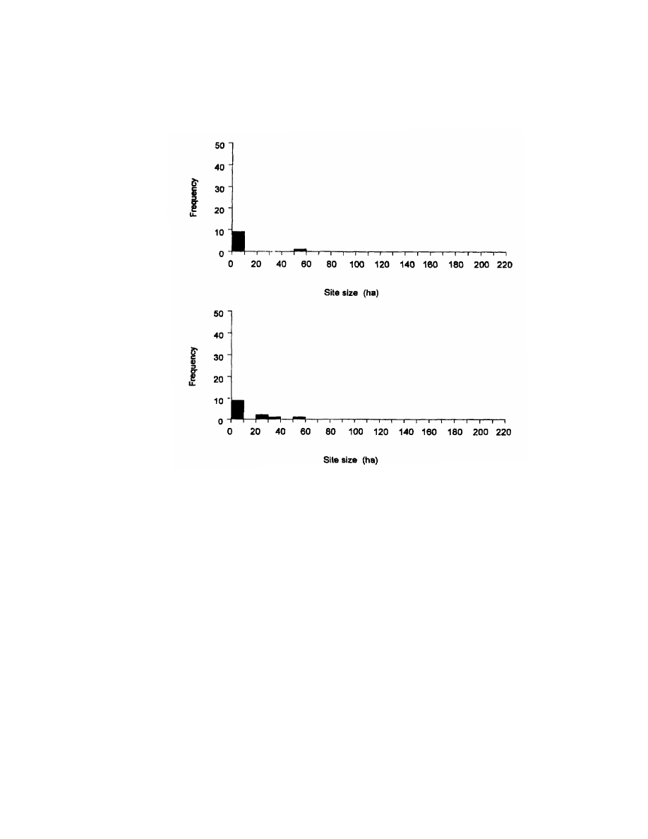
90
Chapter 5
Figure 5.1. Population/settlement size histograms of pre- and post-Mfecane/Difaqane
Zululand.
hectare increased in number from one pre-Mfecane/Difaqane to three
post-Mfecane/Difaqane. Finally, the only large pre-Mfecane/Difaqane
site of 50 hectares, an iron-production site, continued to be occupied
and remained the largest post-Mfecane Difaqane site. The three
additional large sites between 22 and 35 hectares are all royal resi-
dences. Thus the pre- to post-Mfecane/Difaqane transition in Zulu-
land shows the formation of a middle tier of larger royal residences
that probably housed a significant portion of the young male popula-
tion. This, combined with the increase in total sites, suggests that
population increased only after the Mfecane/Difaqane in Zululand.
The site typology suggests that the largest sites were iron-
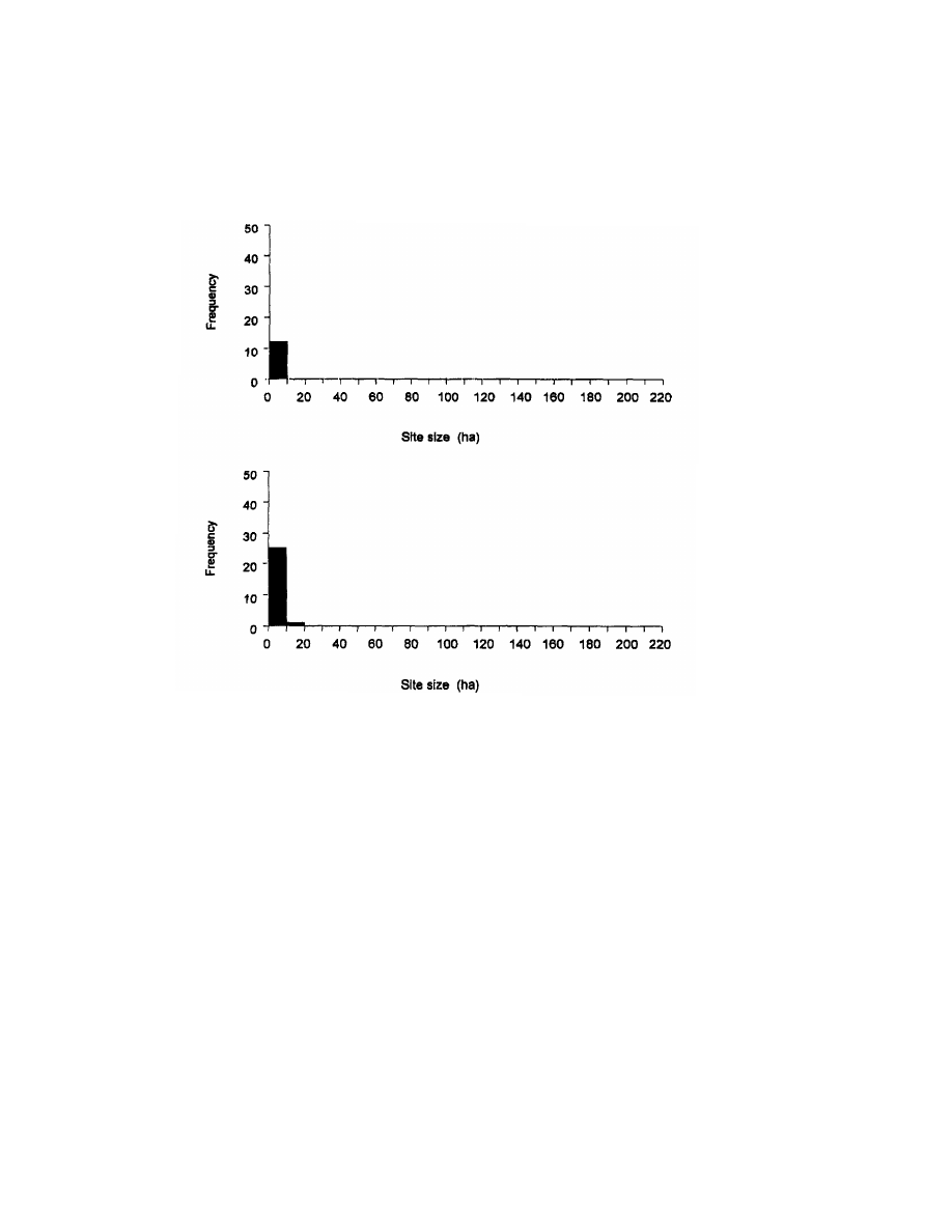
Using Archaeology to Study the Processes of the Mfecane/Difaqane
91
Figure 5.2. Population/settlement size histograms of pre- and post-Mfecane/Difaqane
Swaziland.
production sites, and only later were royal residences among the
larger sites. Thus, the population pressure hypothesis is not sup-
ported by these results because it appears that population increased
after Zulu state emergence rather than before. I suspect that the post-
Zulu state population numbers may actually reflect increasing demo-
graphic densities resulting from population relocation. Therefore, I
attempted to assess regional population densities from different
areas of southeast Africa with archaeological data by analyzing re-
gional site-size transformations through time.
The pre-Mfecane/Difaqane site-size histogram for Swaziland
(Fig. 5.2) exhibits a unimodal distribution with all ”small” sites. In
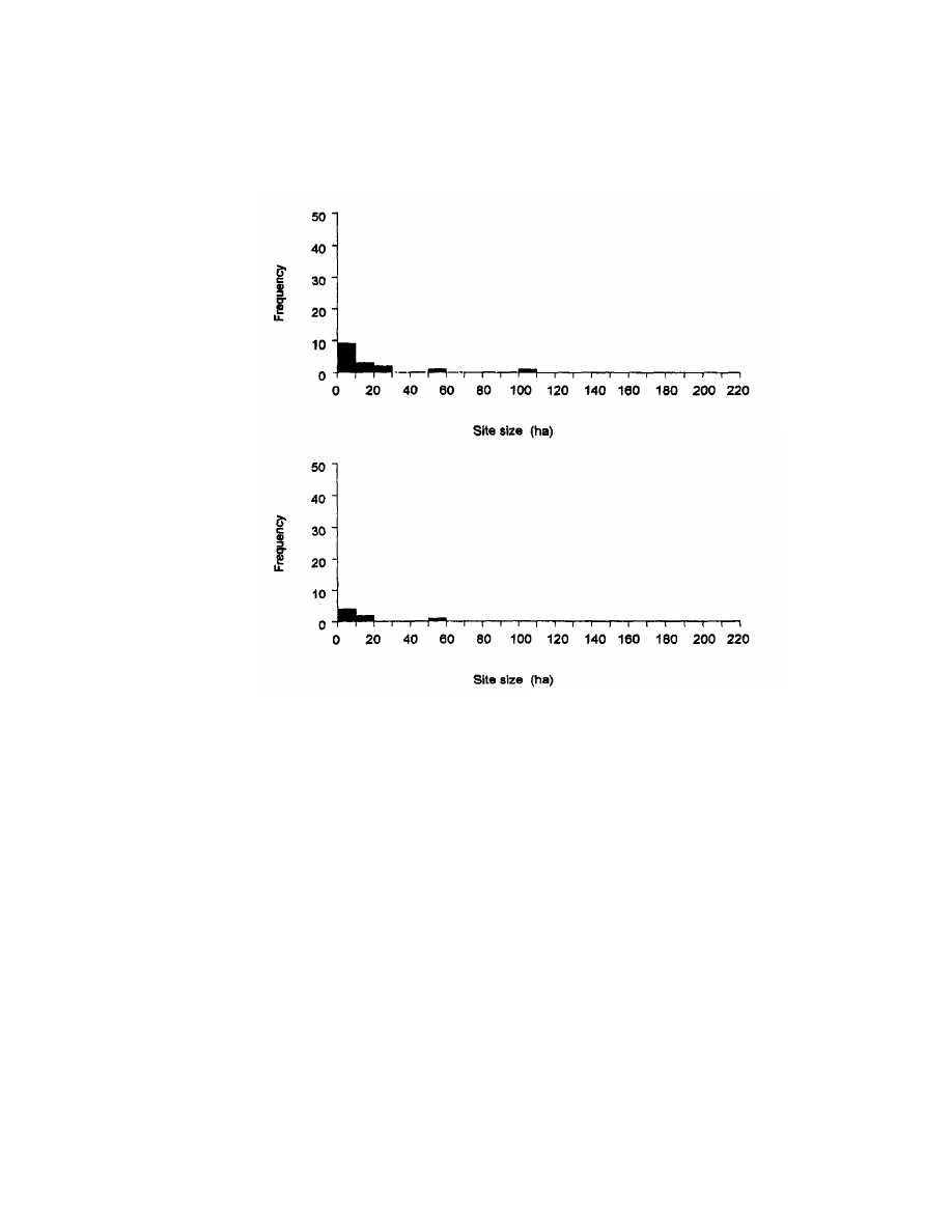
92
Chapter 5
Figure 5.3. Population/settlement size histograms of pre- and post-Mfecane/Difaqane
eastern Transvaal.
the earlier period, there are a total of 12 small sites with a range
of variation between 0.004 to 6 hectares and a mean size of 0.76
hectares.
The later site-size histogram shows a bimodal distribution with
small and medium sites. The later period has 26 sites: 25 small sites
representing 96 percent of the total with a range of variation between
0.003 to 6 hectares and a mean size of 1 hectare; and 1 medium-size
12.5-hectare royal residence representing 4 percent of the total.
Through time, the total number of sites more than doubles, from 12 to
26. After the Mfecane/Difaqane, 11 of the 12 pre-Mfecane/Difaqane
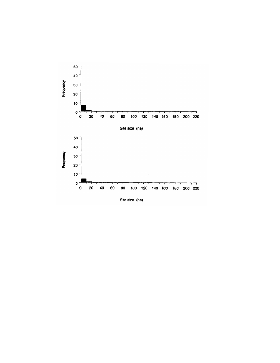
Using Archaeology to Study the Processes of the Mfecane/Difaqane
93
Figure 6.4. Population/settlement size histograms of pre- and post-Mfecane/Difaqane
western Transvaal.
sites continued to be occupied. The one exception is a royal burial site.
Of the 15 sites that emerged after the Mfecane/Difaqane, 8 represent-
ing 54 percent of the total are royal residences; 3 representing 22
percent of the total are primary producer sites. There is also one fort,
one refuge site, one royal grave site, and one production site, each
representing 6 percent of the total.
The transition from pre- to post-Mfecane/Difaqane Swaziland
shows an increase of 14 small sites. This increase represents almost a
doubling of small sites and suggests a significant population increase
at these sites. Through time, only one medium-size site emerges, an
early twentieth-century royal residence. This analysis suggests that
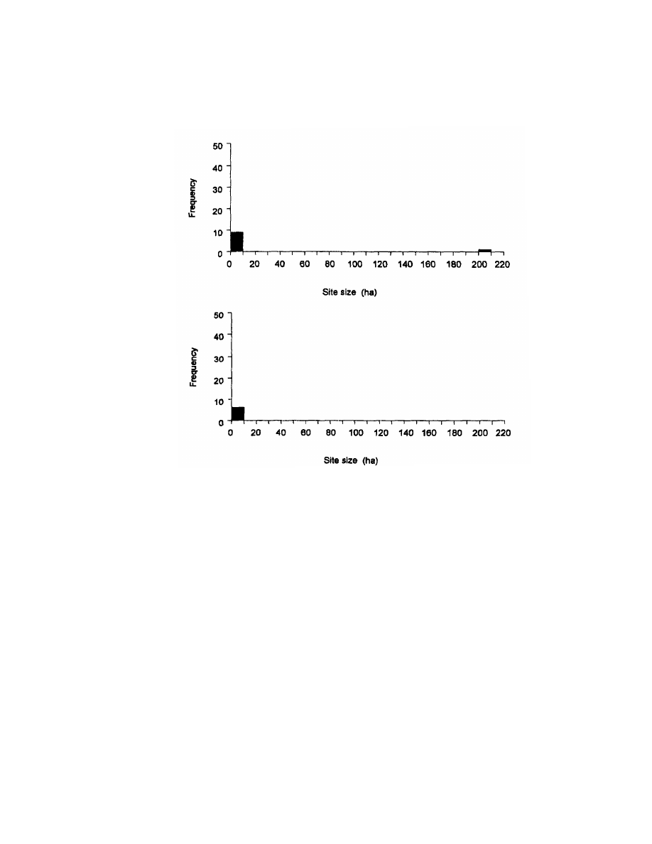
94
Chapter 5
Figure 6.6. Population/settlement size histograms of pre- and post-Mfecane/Difaqane
Free State.
population size in Swaziland increased even more dramatically after
the Mfecane/Difaqane than did that in Zululand and that the in-
crease is concentrated in the small-site-size class.
In the eastern Transvaal, the earlier period has a trimodal settle-
ment hierarchy with a total of 16 sites: 14 small sites with a range of
variation of between 0.01 to 26 hectares and a mean size of 6.3
hectares representing 88 percent of the total; 2 medium-size sites
ranging between 51.2 to 100 hectares and a mean size of 76 hectares
representing 10 percent of the total. The largest site of 100 hectares is

Using Archaeology to Study the Processes of the Mfecane/Difaqane
95
part of a specialized complex of manufacturing sites, which extended
a minimum of 37 square kilometers.
The later site-size histogram shows a bimodal distribution with
small and large sites and a total decrease of nine sites. This period has
six sites: five small sites with a range ofvariation between 0.01 to 16.5
hectares and a mean size of 5.7 hectares representing 83 percent of
the total; and one large site of 51.2 hectares representing 17 percent of
the total. This large royal residence associated with iron production
and other productive activities and primary producer homesteads
remained occupied from the earlier period.
Through time, population size appears to have decreased dra-
matically in the eastern Transvaal in all size classes.
The histogram for the eight pre-Mfecane/Difaqane western
Transvaal sites (Fig. 5.4) shows a bimodal distribution of small- and
medium-sized sites. The six small sites range between 0.03 to 3.24
hectares with a mean site size of 1.3 hectares. The largest site is an
11.25-hectare royal residence.
The five later sites also exhibited a bimodal distribution of small-
and medium-size sites. Small sites range between 0.03 to 1.2, with a
mean site size of 0.6 hectares. The largest site remains the 11.2-
hectare royal residence from the earlier period.
The site-size ranges in the western Transvaal are very similar to
those found in post-Mfecane/Difaqane Swaziland. In both cases, the
largest sites are royal residences. What is different is that there are so
many small sites in Swaziland. Finally, the three small-site decreases
through time suggest that population size in the western Transvaal
decreased.
The histogram for the 10 early sites in the Free State (Fig. 5.5)
sample yielded a bimodal distribution. The 9 small sites ranged
between 0.02 to 1 hectare with a mean site size of .48 hectares,
representing 90 percent of the total. The remaining large site of 200
hectares, probably a royal residence, was substantially larger than
any in the entire southern Africa sample. This one site represents 10
percent of the total.
The five later sites show a unimodal distribution and are all
small sites having a range ofvariation between 0.1 to 1 hectare with a
mean size of 0.57 hectares.
The four small-site decreases through time, coupled with the
disappearance of the very large 200-hectare site, suggest that popula-
tion size in the western Transvaal decreased.
Combined site/population-size histograms for southeastern Af-
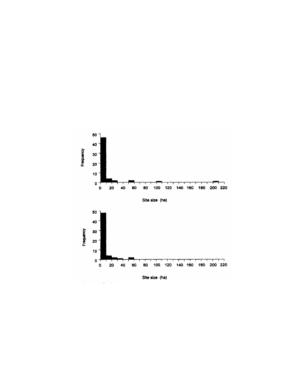
96
Chapter 5
rica (Fig. 5.6) were constructed by using samples from Zululand,
Swaziland, Southern Mozambique, the Free State, the eastern and
western Transvaal, the Cape frontier, and the eastern Cape (Trans-
kei).
The combined site/population-size histograms for southeastern
Africa yielded a multimodal distribution for the pre-Mfecane/Difaqane
period and a bimodal distribution for the later periods (Fig. 5.6). In
the earlier period, there are a total of 56 sites: 52 small sites with a
range of variation between 0.01 to 23 hectares and a mean size of 2.9
hectares, representing 92 percent of the total; 3 medium-size sites
Figure 6.6. Population/settlement size histograms of pre- and post-Mfecane/Difaqane
combined.

Using Archaeology to Study the Processes of the Mfecane/Difaqane
97
with a range of variation between 50 to 100 hectares and a mean size
of 67 hectares, representing 5 percent of the total; 1 large site of 200
hectares, representing 3 percent of the total. The later period has 57
sites: 56 small sites with a range of variation between 0.1 to 35
hectares and a mean size of 3.4 hectares, representing 98 percent of
the total; and 1 medium-size site of 51.2 hectares, representing 2
percent of the total.
The results of the combined regional site size analysis suggest
that through time the overall population in southeast Africa in-
creased slightly, from 56 earlier sites to 57 later ones. It is important
to note that through time all large sites are abandoned and there is a
slight increase in small sites expressed by an increase in their mean
size, which increases from 2.9 hectares to 3.4 hectares.
The most glaring result of these analyses is that the transition
from earlier to later periods was accompanied by a 34 percent de-
crease in total sites (and by implication, people), for all areas except
for Swaziland and Zululand, which showed a 33 percent increase in
total sites and, we assume, an increase in population.
Assuming a correlation between settlement and population sizes
has several limitations. First, there are the difficulties of defining
site size, establishing site boundaries, distinguishing permanent
from temporary occupations, distinguishing site contemporaneity,
and accounting for differential fieldwork intensity. Second, in seeking
to estimate populations, several caveats must be recognized and
adhered to. Combining population figures for different polities from
different times undoubtedly biases data. Furthermore, the organiza-
tional scale and not the population size may be the important vari-
able for understanding the population-resource relation. This vari-
able is measured by the number of basal organizational units like
the number of extended families rather than simply by the number of
individuals (Johnson 1982).
In this regard, more extensive information about the number of
dwellings, structures, and settlement units would have provided a
means to estimate figures for basal organizational unit size. Such
information is rarely available. The population estimates from the
literature for later periods showed an increase in population 51 times
greater than earlier, and population estimates based on population
densities indicated an even greater increase of 349 times larger than
before earlier. Such drastic increases in Zululand most likely reflect
increasing population density, resulting from population agglomera-
tion rather than from general population increase.

98
Chapter 5
To address questions of regional population density, I used the
data for other areas of pre-and post-Mfecane/Difaqane southern Af-
rica including both ethnohistorical and archaeological analyses like
those used in examining Zululand. These regions include samples
from Zululand, Swaziland, the Free State, and the eastern and west-
ern Transvaal.
The ethnohistorical analysis used population estimates for var-
ious southern African groups (Perry 1996a, 402-422).The use of this
data, however, presented particular difficulties. First, population
estimates for post-Mfecane/Difaqane groups far outnumbered pre-
Mfecane/Difaqane estimates. For instance, there are 7 citations giv-
ing population estimates for pre-Mfecane/Difaqane Sotho-Tswana
and 29 for post-Mfecane/Difaqane Sotho-Tswana. An extreme exam-
ple is the Swazi, with no pre-Mfecane/Difaqane demographic infor-
mation and only 2 population estimates for the post-Mfecane/Difaqane.
This bias toward the later periods probably reflects a differential
emphasis on post-Mfecane/Difaqane population estimates.
Furthermore, population estimates were given for particular
“ethnic” groups (e.g., Tlokwa, Pedi, etc.), whereas the larger classi-
fication of Sotho-Tswana was often presented as Sotho-Tswana,
Sotho, or Tswana. Because different groups of Sotho-Tswana inhab-
ited different areas at different times, it is not always clear from the
literature which Sotho-Tswana at what time is being referred to.
Consequently, the Sotho-Tswana were the only other people with
enough information on population size for performing an ethno-
historical population analysis. Although there were some statements
of territorial sizes, there were no population density figures for pre-
Mfecane/Difaqane Sotho-Tswana.
The results of the ethnohistorical analysis of general demogra-
phy show a mean population for pre-Mfecane/Difaqane Sotho-Tswana
of 13,416, whereas post-Mfecane/Difaqane Sotho-Tswana have a
mean population of 183,433. Based on these figures, population
among the Sotho-Tswana after Zulu state formation was about 14
times greater than before the Zulu state emerged.
Site-size data were used to produce population estimates for
Zululand, Swaziland, the eastern Transvaal, the western Transvaal,
and the Free State (Perry 1996a, 348-402).Local population in Zulu-
land, as indicated by total site size, increased substantially, from 78
hectares to 155 hectares in settlement, an increase of 77 hectares.
Local Swaziland population, as indicated by total site size, increased
18 hectares, going from 21 hectares to 39 hectares in settlement.

Using Archaeology to Study the Processes of the Mfecane/Difaqane
99
Eastern Transvaal’s local pre-Mfecane/Difaqane population decreased
dramatically, from 214 hectares in settlement to 80 hectares after the
Mfecane/Difaqane, a decrease of 134 hectares. Local population in
western Transvaal decreased only slightly. Area in settlement went
from 17 pre-Mfecane/Difaqane hectares to 13 post-Mfecane/Difaqane
hectares, a decrease of 4 hectares. Free State population suffered the
most precipitous decrease, falling from 204 pre-Mfecane/Difaqane
hectares in settlement to only 13 post-Mfecane/Difaqane hectares, a
decrease of 191 hectares.
On the basis of the total number of sites per period, overall popu-
lation in southeastern Africa seems to have increased slightly. At the
same time, the total number of hectares in settlement in the south-
eastern African sample dropped by 441 hectares, from 637 hectares
during the pre-Mfecane/Difaqane period to 196 hectares for the post-
Mfecane/Difaqane period. Thus although site number appears to
have remained somewhat stable despite increases and decreases in
certain areas, overall area in settlement was reduced by about 31
percent. These results suggest that populations abandoned certain
areas and clustered in others after the Mfecane/Difaqane. Further-
more, the transition from pre-Mfecane/Difaqane to post-Mfecane/
Difaqane in southeastern Africa was accompanied by a 34 percent
decrease in total sites for all areas except for Swaziland and Zulu-
land, which showed a 33 percent increase in the total number of sites.
The demographic situations in eastern Transvaal and the Free
State are perhaps the most interesting. In terms of regional demo-
graphics, during the earlier periods the eastern Transvaal and Free
State populations were apparently significantly larger than that of
Zululand, but during the later periods as the Zululand population
increased, the eastern Transvaal and Free State populations under-
went an overall reduction, which suggests a population shift from
these areas into Zululand and Swaziland.
The regional evidence then does not support a hypothesis of
population increase before the Zulu state formation. I interpret the
increases in the later numbers as supporting increasing demographic
relocation resulting from warfare combined with captive and cattle
raiding by colonial agents. The raiding for African captives and cattle
probably lessened regional population although increases in demo-
graphic densities resulting from relocation probably did occur and
might well account for increasing population densities following the
Mfecane/Difaqane This explanation might better account for the
slightly smaller regional population accompanied by greater popula-

100
Chapter 5
tion densities in Zululand and the decrease in hectares of settlement
following the Mfecane/Difaqane.
What seems to be occurring are massive shifts in population from
one region to another and a shift from more uniform to more clustered
distributions of sites across the landscape, as would be expected if
warfare was the stimulus for this population movement. Thus the
Mfecane/Difaqane is associated with an unprecedented increase in
the amount of movement induced by violence. In other words, peace
has a centrifugal tendency, spreading primary producer sites across
the landscape, and war has a centripetal tendency, pulling primary
producer populations into centers.
SOCIAL HIERARCHY PREDICTED
BY THE SETTLER MODEL
The Settler Model predicts what kinds of political organizations
existed in specified regions before the Mfecane/Difaqane and what
kinds existed in those regions afterward. Does the archaeological
record support these predictions? There are two major sources of
information used to investigate these assumptions: settlement hier-
archy, as seen in the site-size histograms, and differential control
over cattle, as seen in stock-enclosure sizes. In addition, more tradi-
tional archaeological evidence of social differentiation discussed be-
low is also used in evaluating the Settler Model. I calculated the
percentage of pre- and post-Mfecane/Difaqane sites with evidence of
social hierarchy. I included all sites with oral historic claims to have
been royal residences, sites with elite culling patterns, and the tradi-
tional evidence described below.
Several anthropological scholars concerned with political evolu-
tion have sought ways to archaeologically distinguish states from
other forms of political organizations. Studies investigating archaeo-
logical correlates for “chiefdoms” in southern Africa (Evers and
Hammond-Tooke 1986; Huffman 1984; Taylor 1975) and “middle-
range hierarchical societies” (Taylor 1975) have argued for a system-
atic relation between settlement hierarchies and political organiza-
tion in these societies (Huffman 1984; Taylor 1975). Henry T. Wright
(1977, 381), Johnson (1977, 1978), and Wright and Johnson (1975),
using Near Eastern data, argue that the decision-making organiza-
tion (not necessarily levels of stratification or “symbolized hierarchy”)

Using Archaeology to Study the Processes of the Mfecane/Difaqane
101
of states results in a minimum of three hierarchical levels of settle-
ment size above that of the primary producers.
Other types of archaeological expectations have also been sug-
gested, such as (1) large deposits of cattle bones characterized by an
elite cattle-culling pattern and differential midden distributions
when both elite and nonelite culling patterns occur at capitals;
(2) many large central enclosures and/or courts accompanied by deep
midden deposits; (3) larger and more complex decorated settlement
units with a greater number of wives represented by more dwellings;
(4) a greater variety, number, and concentration of high-status for-
eign commodities and/or specialized goods and resources and/or in-
signia or staffs of office; (5) superstructural archaeological evidence
for centralized control of initiation schools to indoctrinate warriors,
expressed by clay shields and miniature, abstract human and animal
(cattle) figurines associated with elite courts and enclosures; and
(6) differential burial practices, locations, and contents (Evers and
Hammond-Tooke 1986; Evers 1984; Huffman 1986).
Huffman (1984, 1986) argues that class and state formation in
southern Africa is expressed archaeologically by a “Zimbabwe cul-
tural pattern” as distinct from the “Bantu or central culture pattern”
described above. The “Zimbabwe culture pattern” sites house elites
and are represented by much larger “acropolis” sites. These sites are
far larger than any other in the region and are situated on ground
higher than the surrounding area, which contains smaller sites in-
habited by subordinate classes. Elite sites have “prestige” stone wall-
ing, elite burials, a huge court with various elite symbols, a ritual
headquarters, and faunal remains exhibiting an elite cattle-culling
pattern.
Zululand
According to the standard Mfecane/Difaqane model, we should
expect minimally tiered settlement hierarchies in pre-Mfecane/Difa-
qane Zululand along with minimal evidence of social differentiation.
Cattle enclosure sizes should be small to moderate, with faunal
remains characterized by primary producer cattle-culling patterns.
State and class formation should be evident only after the
Mfecane/Difaqane. The artifactual evidence diagnostic of state for-
mation cited above should be present along with a multitiered regional
settlement hierarchy. We should also expect large stock enclosures/

102
Chapter 5
courts with extensive deposits of cattle bones characterized by an
elite cattle-culling pattern.
Swaziland
Similarly, pre-Mfecane/Difaqane sites should have little archi-
tectural, artifactual, or faunal evidence of social hierarchy and fewer
than three tiers in their settlement hierarchy.
Post-Mfecane/Difaqane Nguni sites should be multitiered and
should contain elite objects, large enclosures, and cattle bones with
elite culling patterns. Sotho sites should maintain settlement hier-
archies of three tiers or less, have small enclosures, yield sheep/goat
remains, and contain no elite artifacts.
Eastern Transvaal
There should be little or no archaeological evidence of social
hierarchies at either pre- or post-Mfecane/Difaqane agropastoral
sites and certainly none at pre- or post-Mfecane/Difaqane pastro-
forager sites.
Western Transvaal
Archaeological evidence for social hierarchy should be minimal
at pre- and post-Mfecane/Difaqane agropastoral sites. Faunal re-
mains should be numerically dominated by sheep/goat bones, and
when cattle are present, they should display a primary producer
culling pattern.
Free State
There should be little or no archaeological evidence for pre- or
post-Mfecane/Difaqane social hierarchy at Sotho-Tswana sites. Euro-
pean homesteads located on the frontier should show little evidence
of social hierarchy until after the Mfecane/Difaqane, when Africans
began to seek refuge at these and other European sites. Only post-
Mfecane/Difaqane racially mixed Griqua and Kora sites should ex-
hibit social hierarchy,

Using Archaeology to Study the Processes of the Mfecane/Difaqane
103
ARCHAEOLOGICAL ANALYSIS
Settlement-Size Hierarchies
A settlement-hierarchy analysis was run on both earlier and
later sites in Zululand to investigate the hierarchical relations of
the study area, which might shed light on the Mfecane/Difaqane
explanations. I assumed that all settlements in Zululand were in-
volved in one political economic system. For comparative purposes, a
second set of settlement-hierarchy analyses was run on the settlement-
data samples from Zululand, Swaziland, eastern and western Trans-
vaal, and the Free State. I was particularly interested in the eastern
Transvaal and the Free State because earlier analyses suggest an
inverse relation between these areas and Zululand.
Settlement-unit sizes were tabulated for each period, calculated
in hectares and stated as minimum confirmed sizes. Site/population-
size histograms of settlement sizes for all areas in southeastern
Africa and each period were constructed and the frequency distribu-
tions interpreted to see how many size types exist (Figs. 5.1-5.6).
These histograms have been described in detail earlier. Each site type
was defined in terms of (1) mean size, (2) range of variation, (3) num-
ber of sites belonging to that type.
Some tripartite schemes have been developed for southern Afri-
can settlements like that used by Wright and Kus (1979) for sites in
central Imerina, Madagascar: small equals 1 to 0.49 hectares; me-
dium equals 0.50 to 3.0 hectares; and large equals more than 3.0
hectares. For Botswana, Denbow and Wilmsen (1986) also defined
three categories: hamlets equal 0.1 hectares; middle-range (hinter-
land secondary villages) equal 1 hectare; and capitals or large towns
equal 10 hectares.
Huffman (1984, 1986) has proposed a positive correlation be-
tween the degree of political stratification and the number of site-
size modes for southern African agropastoral polities. He argues
that the levels of the political hierarchy have a corresponding site-
size hierarchy of anywhere from two to six levels with most popula-
tions having two-tier political and settlement hierarchies (Huffman
1984,19). His hierarchies include “petty chiefs” who have three-tier
hierarchies with small settlements about the same size; “senior
chiefs” and above who have four levels; and “paramount chiefs” with
five-plus-level hierarchies. Furthermore, the larger-size level is
sometimes three or four times the size of the small base of settle-

104
Chapter 5
ments near agricultural fields, which typically accommodates more
than one-half of the population (Huffman 1984, 2, 1986, 292). It is in
this five-tier hierarchy that he places the Zulu, Swazi, and Sotho.
Furthermore, Huffman argues that this correlation between set-
tlement size and political stratification also includes the number and
size of courts, cattle, agricultural fields, wives, population, and terri-
tory controlled (Huffman 1984,3-6, Huffman 1986,293). He suggests
that these relations increase and are most clearly evident at the
upper levels of a hierarchy when comparing capitals whose absolute
size and relative differences from subordinate settlements are most
marked because of the many activities and elite individuals and
their retainers located there (Huffman 1984, 4-6, 1986, 294).
I examined the site-size histograms to see whether Huffman’s or
Denbow and Wilmsen’s model fit the southeastern African data and
to see what kinds of political organizations existed in southeastern
Africa before and after the Mfecane/Difaqane. The point of the
settlementipopulation-sizehierarchy discussion is that the complex-
ity of political organization after the Mfecane/Difaqane is expected to
be greater than it was before, according to the Settler Model. There-
fore, the issue is not whether hierarchy was absent before Mfecane/
Difaqane times, but rather whether there was less hierarchy.
INTERPRETATIONS OF SOCIAL HIERARCHY
BASED ON HISTOGRAMS,
ORAL TRADITIONS, AND ARTIFACTS
Zululand
Pre-Mfecane/Difaqane Zululand sites exhibit a two-tier settle-
ment hierarchy, Although 19 sites were classified as royal residences,
there was no artifactual or mortuary evidence of social differentiation
at these sites. Of the 27 pre-Mfecane/Difaqane sites, 19, representing
70 percent of the total, have artifactual evidence of social hierarchy
including oral history accounts claiming them as royal residences
(see Perry 1996a, 348-56, Table 1).
Post-Mfecane/Difaqane Zululand had a trimodal settlement hi-
erarchy with ll fewer royal residences than earlier and no artifactual
or mortuary evidence of social differentiation. However, of the 22
post-Mfecane/Difaqane sites, 9, representing 41 percent of the total,

Using Archaeology to Study the Processes of the Mfecane/Difaqane
105
have artifactual evidence of social hierarchy (see Perry 1996a, 348-
56, Table 1).
The pre- and post-Mfecane/Difaqane Zululand patterns do not
correspond to Huffman’s five- and six-tier political levels predicted
for the Zulu. The greatest increase in sites through time is in
medium-size sites. Furthermore, the largest site for both periods is
not a royal residence as expected but rather an iron-production site,
significantly larger than all others in the earlier period and continu-
ing to be occupied. Only during the post-Mfecane/Difaqane did royal
residences become larger, and even then they remained smaller than
the largest iron-production site. The evidence from oral traditions
and artifacts indicates a 30 percent decrease in the percentage of
sites with elite material culture.
Thus, the archaeological evidence suggests that the sociopolitical
situation in Zululand is quite complex. The argument for increasing
social hierarchy after the Mfecane/Difaqane in Zululand is only par-
tially supported. Although elite site sizes increase through time, their
total number decreases. Furthermore, none of the pre-Mfecane/
Difaqane sites contains elite material culture, and the percentage of
sites with such goods decreases. Yet, it appears that not only were
there many elite sites before the Mfecane/Difaqane, but there were
also fewer elite sites after the Mfecane/Difaqane. Finally, the largest
earlier and later site is an iron-production site.
State formation outside Zululand apparently resulted in many
competitors in the pre-Mfecane/Difaqane who did not monopolize
access to surplus. This situation is followed by the emergence of a
single Zulu state with the ability to control surplus, and thus elite-
looking sites appear.
Swaziland
Pre-Mfecane/Difaqane sites have a unimodal settlement hier-
archy with the largest site being a 6-hectare royal residence. Of the
12 pre-Mfecane/Difaqane sites, 5, representing 42 percent of the total
have artifactual evidence of social hierarchy (see Perry 1996a, 357-
64, Table 2).
Despite the fact that the largest post-Mfecane/Difaqane site is a
12.5-hectare royal residence, the settlement-size hierarchy indicates
a continuation of minimal social hierarchies in post-Mfecane/Difaqane
Swaziland. Of the 30 post-Mfecane/Difaqane Swaziland sites, 16,

106
Chapter 5
representing 53 percent of the total, have artifactual evidence of
social hierarchy.
The archaeological evidence for sociopolitical organization in
Swaziland, not unlike that for Zululand, is complex. For instance,
the settlement hierarchy shows the maintenance of a unimodal dis-
tribution of small sites, combined with a slight increase in the per-
centage of sites with elite items.
Eastern Transvaal
Contrary to the Settler Model predictions for pre-Mfecane/Difa-
qane eastern Transvaal, the largest site observed is twice as large as
the largest site in Zululand (an iron-production site) during any time
period. A second royal residence, the same size as the largest Zulu-
land site, shows evidence of involvement in large-scale mineral pro-
duction. The material culture, faunal remains, and burials from
many sites, including the very large site, suggest pastroforager occu-
pation and the presence of social hierarchy.
Of the 22 pre-Mfecane/Difaqane sites, 7, representing 32 percent
of the total, have artifactual evidence of social hierarchy (see Perry
1996a, 348-56, Table 4). Furthermore, sites with agropastoral mate-
rial objects are far smaller than those with pastroforager artifacts.
The decrease from an early three-tier settlement hierarchy to a
later two-tier site-size hierarchy suggests a decrease in social hier-
archy. Of the 15 post-Mfecane/ Difaqane sites, 8, representing 53
percent of the total, have artifactual evidence of social hierarchy.
The archaeological evidence is once again ambiguous on the issue of
increasing social hierarchy. The decrease in settlement tiers suggests
a decrease in social hierarchy, whereas there is an increase in the
percentage of sites with elite material culture. Finally, other provoca-
tive archaeological evidence, such as the abandonment of the largest
earlier specialized production site, “pastroforager” sites with evi-
dence of social hierarchy, and the continued occupation of the largest
royal residence, demonstrates the complexity of social hierarchy in
eastern Transvaal.
Western Transvaal
The pre- and post-Mfecane/Difaqane site-size distributions are
unimodal for western Transvaal, which suggests no increase in social
hierarchy. Of the 19 pre-Mfecane/Difaqane sites, 5, representing 26

Using Archaeology to Study the Processes of the Mfecane/Difaqane
107
percent of the total, have artifactual evidence of social hierarchy. Of
the 8 post-Mfecane/Difaqane sites, 2, representing 25 percent of the
total, have other kinds of evidence of social hierarchy (see Perry
1996a, 382-91,Table 5).
In the western Transvaal, both the site-size analysis and the
artifactual analysis suggest that social hierarchy remained the same.
This conclusion is also supported by the fact that the largest site in
both periods is a 11.2-hectare royal residence. Furthermore, artifac-
tual, architectural, and faunal differences, ascribed in the Settler
Model to ethnic and subsistence differences, seem to be less apparent
here than in the eastern Transvaal.
Free State
The Free State pre-Mfecane/Difaqane site-size distribution is
bimodal. Yet, the one large site of 200 hectares, probably a royal
residence, is the largest site in the entire southeastern African sam-
ple. In addition, this huge site has evidence of social hierarchy and
pastroforager occupation. Of the 14 pre-Mfecane/Difaqane sites, 9,
representing 64 percent of the total, have evidence of social hierarchy,
whereas 7, representing 50 percent of the total, have archaeological
evidence of social hierarchy and pastroforaging (see Perry 1996a,
392-99,Table 6).
The unimodal distribution of all small sites, 1 hectare or less,
displayed by the later sites strongly suggests a decrease in social
hierarchy. Yet, of the 10 post-Mfecane/Difaqane sites, 6, representing
60 percent of the total, have other evidence indicating social hier-
archy, whereas 5, representing 50 percent of the total, have archaeo-
logical evidence of social hierarchy and pastroforaging. The evidence
from Free State settlement-size hierarchies and the decrease in the
percentage of sites with material culture expressions of social hier-
archy suggest a decrease in social hierarchy through time.
Site-size histograms for southeastern Africa suggest a transfor-
mation from a multimodal settlement hierarchy to a bimodal settle-
ment hierarchy, indicating a decrease in social hierarchy through
time. The general results of the regional site-size analysis and arti-
factual analysis are complex and varied. Only the settlement hier-
archies from Zululand show an increase in evidence for social hier-
archy, with all other regional hierarchies decreasing. Simultaneously,
other archaeological evidence in all regions indicates the opposite
result for social hierarchy formation over time.

108
Chapter 5
The most intriguing area is the Free State, whose early bimodal
distribution contained a very large site, OFD 1, which is four times
larger than the largest in Zululand and is the largest site in the entire
southeastern African sample. This elite site is particularly interest-
ing for other reasons besides its huge size. The faunal assemblage,
although dominated by wild game and containing marine resources,
is characterized by an elite cattle-culling pattern along with sheep/
goat. There is evidence of glass beads and bead production, copper,
rock gongs, and miniature pots, suggesting initiation or other ritual
practices. Also, there are burials with stone-lined tombs and many
grave goods. Stone tools, red ochre chunks, bored stones, and undeco-
rated grass-tempered pottery typical of ethnographic pastroforagers
are also present. Finally, there is evidence of at least one burnt
dwelling, and the site was no longer occupied during the later periods.
The most provocative regional relation is seen in the transition
from earlier to later periods, accompanied by a 34 percent decrease in
total sites for all areas except for Zululand and Swaziland, which
showed a 33 percent increase in total sites. This relation strongly
suggests that Zululand and Swaziland were experiencing similar
transformations, which were having the opposite affect on the other
regions. This core area containing Zululand and Swaziland may
represent state-formation processes. In addition, the increase and
concentration of small sites in this area could suggest that Swaziland
is peripheral to the Zululand core area.
After the emergence of the Zulu state, the Free State sites exhibit
a unimodal distribution of all “small” sites less than 1 hectare. The
largest site is Khartoum I, a 1-hectare primary producer site that was
occupied in the earlier period as well and is located about 50 kilome-
ters west of the now-abandoned OFD 1. Khartoum I contains glass
beads from the Atlantic coast, undecorated grass-tempered ceramics,
and both cattle and wild game (Humphreys 1982; Maggs 1977).
These analyses suggest that earlier periods were perhaps more
peaceful than later times because the smaller (primary producer) and
large (production) sites were more evenly distributed spatially across
the region. Furthermore, the fact that the largest early site in Zulu-
land was an iron-production site could suggest less stratified social
relations and iron production for local markets. Finally, the larger
production sites were all outside Zululand.
In sum, the structural evidence from settlement hierarchies
alone is very misleading: The evidence for social hierarchy is quite
complex and dependent on the number and kinds of evidence se-

Using Archaeology to Study the Processes of the Mfecane/Difaqane
109
lected for analysis. Furthermore, different regions experienced social
hierarchy differently at different times. Whatever the case, the Settler
Model’s prediction of increasing social hierarchy after the Mfecane/
Difaqane is not supported. The evidence from these limited analyses
indicates that the situation was far more complex.
CATTLE ENCLOSURE SIZES
In Chapter 3, I discussed the political economy of cattle in south-
ern Africa and stated that differential possession of cattle and their
accumulation are key indicators of social inequality among southern
African polities. Consequently, cattle enclosure size can heuristically
be used as a surrogate to inform on status, wealth, and power, and
hence class and state formation in southern African societies.
Hall has combined the concept of “animal unit” (AU) from Mentis
and Duke (1976) with modern Zulu herders’ estimates of possible
numbers of cattle housed at Zululand archaeological sites to devise a
formula to estimate AUs on cattle enclosure size. He estimated a
requirement of 5 square meters per adult animal in a herd enclosure.
He then used this number to estimate the total herd size of each
region in his Zululand study area (Hall 1981, 135 and 158).
Other Africanist scholars have derived mean central enclosure
sizes. For instance, Denbow and Wilmsen’s (1986, 13) middle range
sites in Botswana have central enclosure sizes 70 meters in diameter
(3,848 m
2
area). Maggs (1971, 42-44) measured cattle enclosures
sizes of the Riet River settlement units in describing the structure of
his Type R settlements. His histograms revealed two distinct size
classes: many small enclosures between 2 to 14 meters in diameter
(3-154 m
2
area) and few large enclosures ranging between 21 to 70
meters in diameter (346-3,848 m
2
area). He suggested functional
differences in terms of adult and juvenile animals or cattle versus
sheep/goat. Maggs also noticed that there was at least one large
enclosure on every settlement unit and that only small enclosures
were isolated from settlement units. Huffman (1984) stated that 50-
meter diameter (1,963 m
2
area) central enclosures are representative
of small, weak “petty chiefdoms” or a ward headperson.
The goal of my analysis was to gauge the wealth of the different
sites through time to assess whether any changes resulted from Zulu
state emergence. Because cattle, sheep, and goats all represent
wealth in some form, a standardized faunal unit was thought to be

110
Chapter 5
appropriate. I used the formula for the area of a circle
to calcu-
late the enclosure size in square meters. Then following Hall (1981,
137), I divided the enclosure area by 5 square meters per adult ani-
mal to obtain an estimate of “animal units” penned at each enclosure
and at each settlement.
Early and later period central enclosure sizes were then tabu-
lated in square meters for all areas with faunal data by period, and
histograms for both were generated (Figs. 5.7-5.12). An estimated
number of AUs based on Hall’s formula were also calculated (see
Perry 1996a, 423-441and 479-481).
Archaeological Expectations
Zululand
Pre-Mfecane/Difaqane Zululand cattle enclosure sizes should be
small to moderate, with faunal remains characterized by primary
producer cattle-culling patterns. Post-Mfecane/Difaqane Zululand
should have large stock enclosures/courts with extensive deposits of
cattle bones characterized by an elite cattle culling pattern.
Swaziland
Pre-Mfecane/Difaqane Nguni cattle enclosure sizes in Swaziland
should be small to moderate, with faunal remains characterized by
primary producer cattle-culling patterns. Sotho cattle enclosure sizes
should be small and contain mostly sheep/goat bones.
Post-Mfecane/Difaqane Nguni agropastoral sites should show
evidence of numerous cattle bones and larger stock enclosures than
at Sotho sites yet smaller than those in Zululand. Sotho sites should
have fewer and smaller animal enclosures with sheep/goat remains.
Eastern Transvaal
Pre-Mfecane/Difaqane pastroforager sites should have small
and very few, if any, livestock enclosures and cattle bones. The few
Sotho agropastoral sites should have small- to moderate-size animal
enclosures and some cattle remains.
Post-Mfecane/Difaqane pastroforager sites should have no live-
stock remains or enclosures. Nguni agropastoral sites should have
few and small enclosures and livestock remains with primary pro-
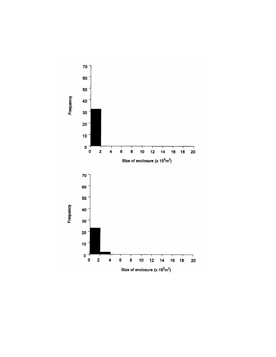
Using Archaeology to Study the Processes of the Mfecane/Difaqane
111
Figure 5.7. Enclosure-size histograms of pre-
and post-Mfecane/Difaqane Zululand.
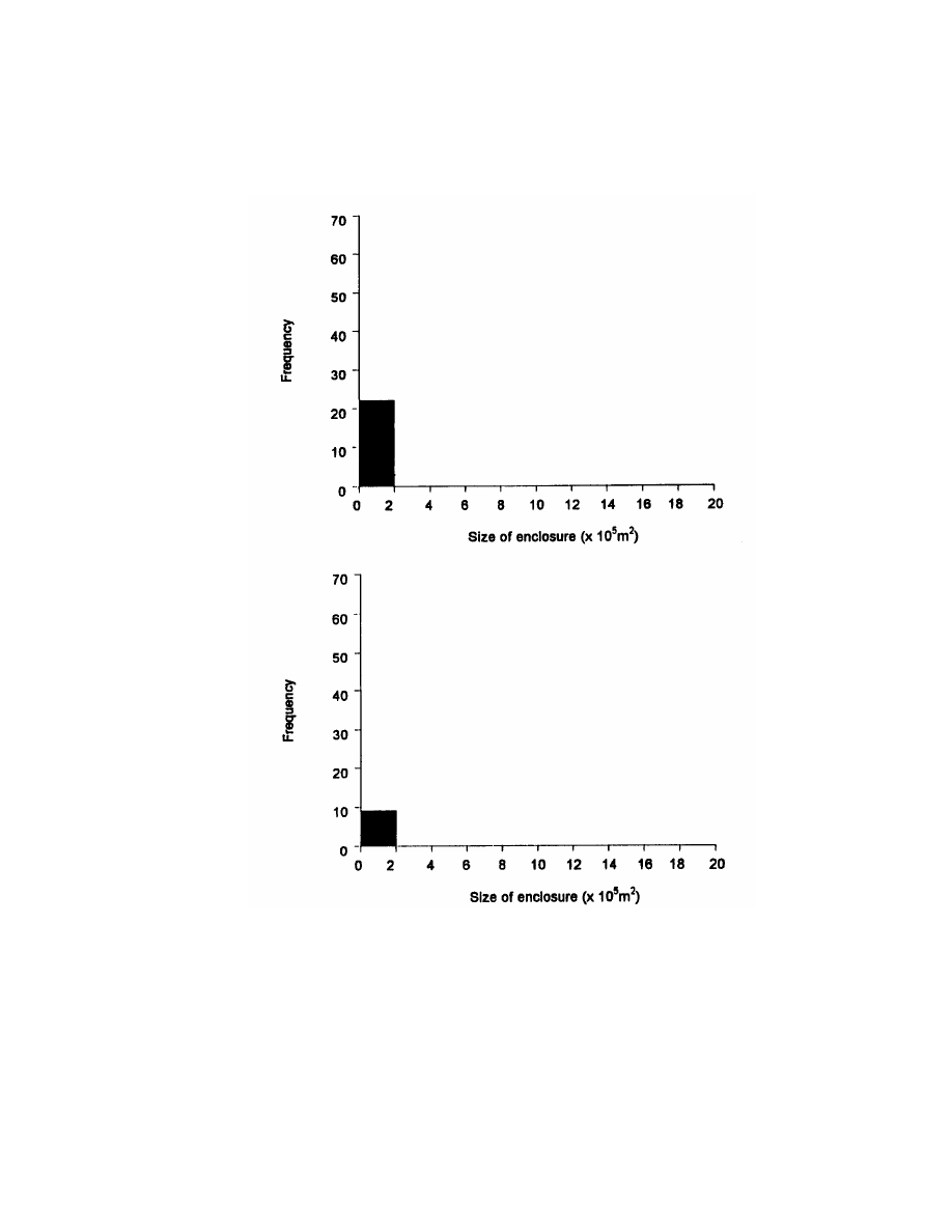
112
Chapter 5
Figure. 6.8. Enclosure-size histograms of pre- and post-Mfecane/Difaqane Swaziland.
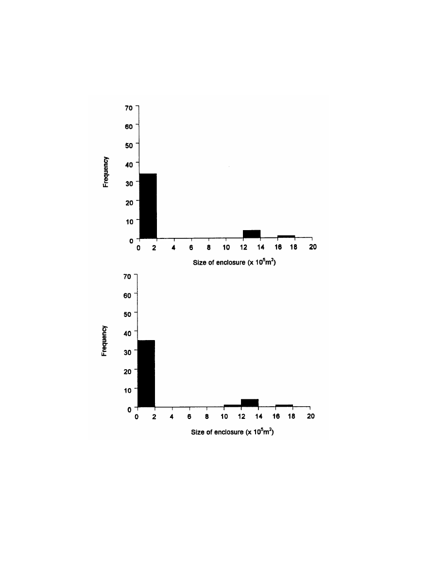
Using Archaeology to Study the Processes of the Mfecane/Difaqane
113
Figure 5.9. Enclosure-size histograms of pre-
and post-Mfecane/Difaqane eastern
Transvaal.
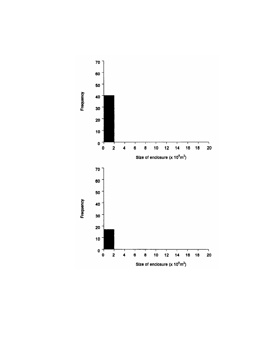
114
Chapter 6
Figure 5.10. Enclosure-size histograms of pre-
and post-Mfecane/Difaqane western
Transvaal.
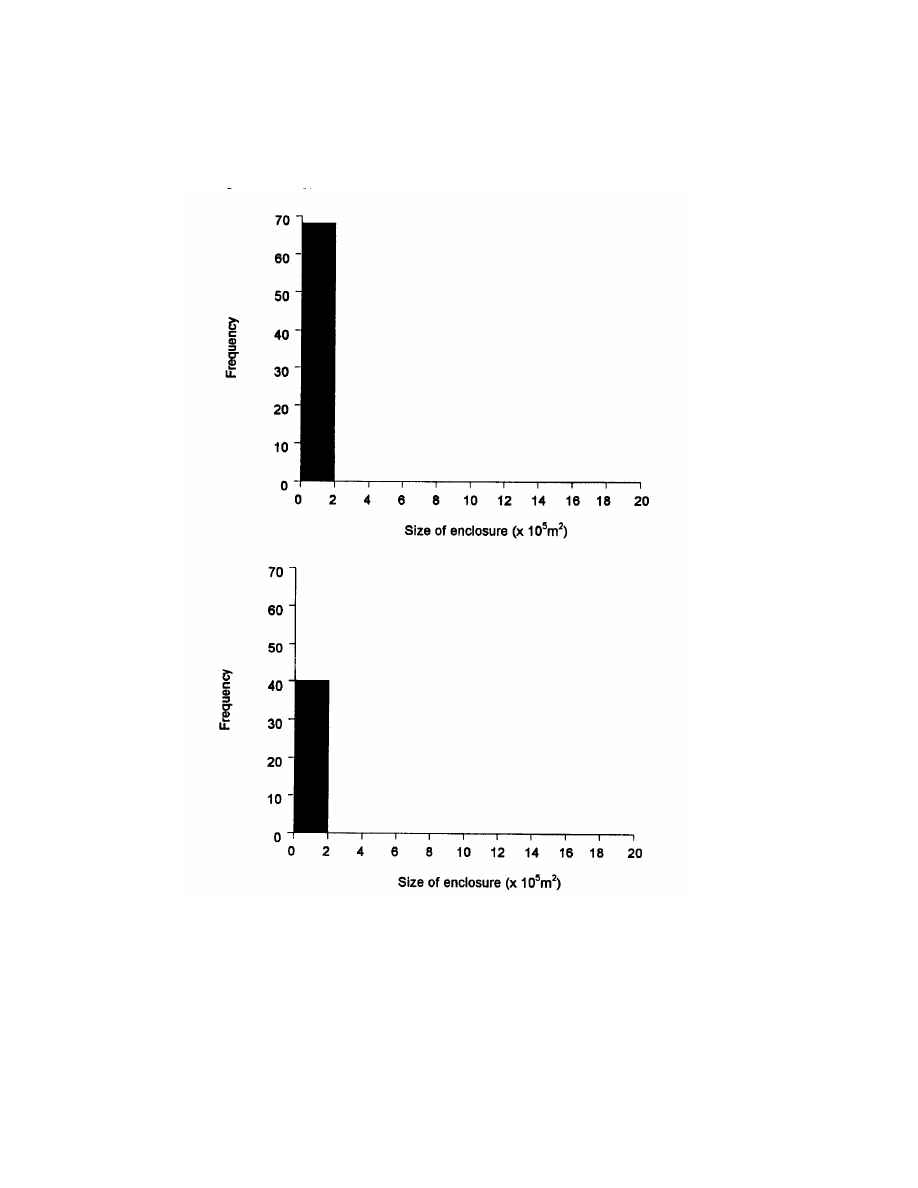
Using Archaeology to Study the Processes of the Mfecane/Difaqane
115
Figure 5.11. Enclosure-size histograms of pre-
and post-Mfecane/Difaqane Free
State.
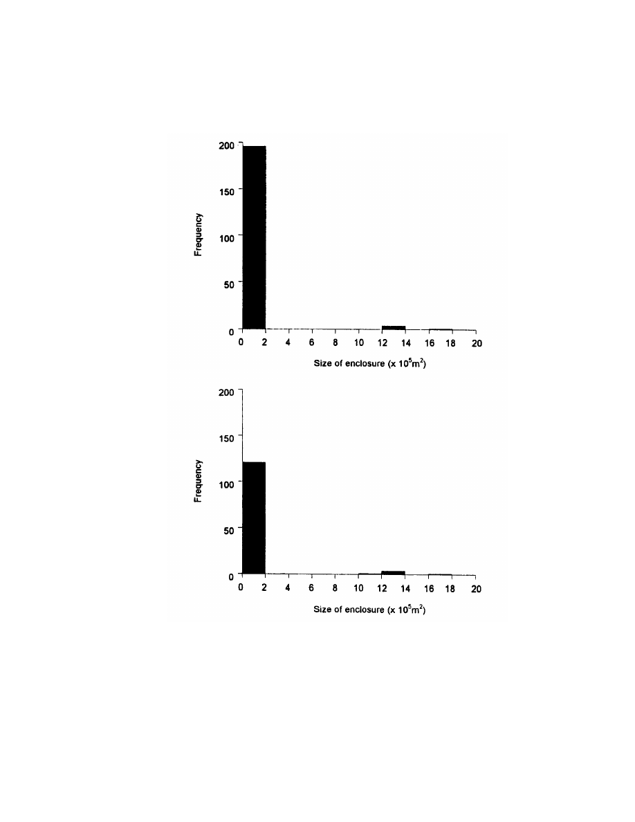
116
Chapter 5
Figure 5.12. Enclosure-size histograms of pre-
and post-Mfecane/Difaqane southern
Africa combined.

Using Archaeology to Study the Processes of the Mfecane/Difaqane
117
ducer patterns. Sotho-Tswana agropastoral sites should have small
livestock enclosures dominated by sheep/goat remains.
Western Transvaal
Pre-Mfecane/Difaqane Sotho-Tswana agropastoral sites should
have few small- to medium-size animal enclosures with few cattle
remains, exhibiting primary producer patterns, and some sheep/goat
remains. Post-Mfecane/Difaqane Sotho-Tswana sites should have
more small stock pens dominated by sheep/goat remains.
Free State
Pre-Mfecane/Difaqane Sotho agropastoral sites should have
moderate-size stock enclosures with primary producer cattle pat-
terns and some sheep/goat remains. Post-Mfecane/Difaqane Sotho
and Nguni agropastoral sites should have small protected stock pens
with mostly sheep/goat remains.
ANALYSIS AND RESULTS
Histogram Interpretations
In interpreting the enclosure-size histograms, I assumed that
larger cattle enclosure sizes represent more cattle and hence a
greater degree of social hierarchy.
Zululand
The pre-Mfecane/Difaqane enclosure-size histogram for Zulu-
land exhibits a unimodal distribution, and the post-Mfecane/Difaqane
distribution is bimodal (Fig. 5.7). In the earlier period, there are 32
small enclosures with a range of variation between 7 to 1,257 square
meters and a mean size of 105 square meters.
The later period has 25 enclosures, a decrease of 7 enclosures.
There are 24 enclosures with a range of variation between 7 and
331,830 square meters and a mean size of 30,130 square meters,
representing 96 percent of the total; and 1 enclosure of 331,830
square meters, representing 4 percent of the total. These findings
suggest increasing social hierarchy in Zululand.

118
Chapter 5
The evidence from cattle enclosure histograms in Zululand sug-
gests that livestock was more evenly distributed during the earlier
period, but became more concentrated into larger enclosures during
the later period. Overall, livestock and/or royal courts, and conse-
quently social hierarchy, increased tremendously after the Mfecane/
Difaqane as predicted by the Settler Model.
Swaziland
The pre- and post-Mfecane/Difaqane enclosure-size histograms
for Swaziland exhibit a unimodal distribution with all small sites for
both periods (Fig. 5.8). In the earlier period, there are 22 small
enclosures with a range of variation between 3 and 7,854 square
meters and a mean size of 708 square meters. The later period has 9
enclosures, a decrease of 13 enclosures. These enclosures have a
range of variation between 314 and 2,827 square meters and a mean
size of 1,130 square meters.
There appears to have been a dramatic decrease in the number of
small enclosures through time, accompanied by a significant increase
in mean enclosure size from 708 to 1,130 square meters, yet none as
large as the earlier 7,854 square meters enclosure. The continuation
of small enclosure sizes through time suggests that no increase in
social hierarchy occurred. The increase in mean enclosure size indi-
cates that through time fewer people had access to livestock and/or
that livestock was being aggregated into fewer and larger enclosures.
Eastern Transvaal
The pre- and post-Mfecane/Difaqane enclosure-size histograms
for eastern Transvaal exhibit a trimodal distribution (Fig. 5.9). In the
earlier period, there are 38 enclosures with a range of variation be-
tween 7 and 1,767,145 square meters and a mean size of 886 square
meters. Of the 38 earlier enclosures, 33, representing 87 percent of
the total, were between 7 and 9,503 square meters; 4 enclosures,
representing 11 percent of the total, were all 1,227,184 square meters;
and 1 enclosure, representing 2 percent of the total, was 1,767,145
square meters.
The later period has 41 enclosures, an increase of 3 enclosures,
with a range of variation between 3 and 1,767,145 square meters and
a mean size of 192,190 square meters. There are 35 enclosures, rep-
resenting 85 percent of the total, between 3 and 9,503 square meters
and a mean size of 2,028 square meters; 5 enclosures, representing

Using Archaeology to Study the Processes of the Mfecane/Difaqane
119
13 percent of the total, between 1,130,973 and 1,227,184 square me-
ters and a mean size of 28,274 square meters; and 1 enclosure of
1,767,145 square meters representing 2 percent of the total. This
distribution suggests that there was little change in social hierarchy
through time in eastern Transvaal.
There is a slight increase of three enclosures through time, two in
the small-size range and one in the medium-size range. This evidence
suggests that social hierarchy was present early, and continued dur-
ing the later periods. The 200-plus increase in mean enclosure size
through time, from 886 to 192,190 square meters, seems to indicate an
aggregation of livestock at larger enclosures.
Western Transvaal
The pre- and post-Mfecane/Difaqane enclosure-size histograms
for eastern Transvaal exhibit a unimodal distribution of small enclo-
sure sizes (Fig. 5.10). In the earlier period, there are a total of 40 small
enclosures with a range of variation between 1 and 104,635 square
meters and a mean size of 2,682 square meters.
The later period has 17 very small enclosures, a decrease of 23
enclosures, with a range of variation between 1 and 50 square meters
and a mean size of 24 square meters. The enclosure-size histograms
suggest that during the early period in the western Transvaal live-
stock was fairly evenly distributed. The histograms also indicate that
social hierarchy through time in the western Transvaal remained at
the same minimal level. Although the social hierarchy did not
change, there is a drastic decrease in number of enclosures and mean
enclosure size from 2,682 to 24 square meters, with the largest enclo-
sure only 50 square meters in area. Furthermore, 88 percent of all
later sites had very small enclosure sizes of about 1 square meter.
Using Hall's AU estimate of 5 square meters per adult animal sug-
gests that no adult animals were present in these very small enclo-
sures and only 10 adult animals in the 50-square meter enclosure.
These results strongly suggest a significant decrease in number of
enclosures and enclosure sizes and hence a loss of livestock through
time, whereas social hierarchy remained the same during the later
periods in the western Transvaal.
Free State
The pre- and post-Mfecane/Difaqane enclosure-size histograms
for the Free State have unimodal distributions of small enclosure

120
Chapter 5
sizes (Fig. 5.11). In the earlier period, there are 68 small enclosures
with a range of variation between 1 and 1,662 square meters and a
mean size of 162 square meters. The early period Free State enclosure-
size histogram suggests that livestock was fairly evenly distributed.
The later period has 40 small enclosures, a 59 percent decrease of
28
enclosures, with a range of variation between 1 and 3,848 square
meters and a mean size of 193 square meters. The dramatic decrease
in the number of enclosures is most apparent in the under-1,000-
square meters-size ranges. Despite a decrease in the number of en-
closures greater than 1,000 square meters from 4 to 2, the largest
later period enclosure is slightly larger than 3,000 square meters.
Not unlike the western Transvaal, the Free State enclosure-size
histograms suggest that through time there was a fairly even live-
stock distribution; a significant decrease in total enclosures; and a
continuation of minimal social hierarchy.
The combined enclosure-size histograms for southeast Africa
yielded trimodal distributions for both periods (Fig. 5.12). In the
earlier period, there are 200 enclosures with a range of variation
between 1 and 1,767,145 square meters and a mean size of 855
square meters. The later period has 132 enclosures, a 66 percent
decrease of 68 enclosures, with a range of variation between 1 and
1,767,145
square meters and a mean size of 6,554 square meters.
The trimodal distribution histogram patterns for the combined
southeastern Africa enclosure sizes most closely resembles the pat-
terns from the eastern Transvaal. These combined results for south-
eastern Africa suggest that social hierarchy and livestock distribution
remained essentially the same in southeastern Africa through time.
In sum, the cattle enclosure analysis suggests that only in east-
ern Transvaal and southeastern Africa was there the presence of a
continuous social hierarchy Every region except eastern Transvaal
(which gained three enclosures) showed a decrease in the number of
cattle enclosures through time. This was also the trend for south-
eastern Africa.
If we look at each region in terms of total enclosure areas pre-
sumably housing livestock and mean enclosure size, a different, more
complex pattern emerges. Zululand showed an increase in both areas
enclosed and mean cattle enclosure size. Swaziland exhibited a de-
crease in areas enclosed and an increase in mean cattle enclosure
size. Eastern Transvaal, like Zululand, increased in both categories,
whereas western Transvaal decreased in both categories. Free State,
like Swaziland, increased in areas enclosed and decreased in mean

Using Archaeology to Study the Processes of the Mfecane/Difaqane
121
enclosure size. Southeastern Africa, like Zululand and eastern
Transvaal, increased in both categories. Obviously, southeastern Af-
rica is very misleading in terms of structure expressed by enclosure-
size histograms. Using the number of total areas enclosed and mean
enclosure size by region and periods reveals the complexities involved
in understanding changing social hierarchy through time.
Worksheets
The results of the analyses on animal units by region and by
period are summarized as follows: the four early measurable enclo-
sures from Zululand yielded a mean number of AUs per central
enclosure of 90, and the mean AUs for all enclosures is 134 (see Perry
1996a, Appendix 6,479-81, for all worksheets). Later central enclo-
sures yielded a mean of 30,082 AUs in central enclosures and a mean
of 30,130 AUs for all enclosures. Furthermore, there was a total
increase of 149,980 AUs in Zululand.
These results suggest that the number of cattle penned increased
dramatically during the later periods in Zululand. The three later
period sites that had the most AUs were all royal residences whose
central enclosure was the only enclosure. The smallest of these enclo-
sures has 32,555 more AUs than the largest early site. This finding
supports the argument for an increasing social hierarchy after the
Mfecane/Difaqane. Because all these sites were royal residences, it is
highly probable that the extensive size of the central enclosures
reflected the court sizes rather than or in addition to cattle enclosures.
The four early measurable enclosures from Swaziland have a
mean of 453 AUs in central enclosures, 779 AUs in all enclosures,
and a total of 3,114 AUs. The three later enclosures have a mean of 210
AUs in central enclosures, a mean of 678 AUs in all enclosures, and
a total of 2,034 AUs.
The evidence from the AU analysis shows that livestock numbers
decreased through time in Swaziland. The sites with the most AUs in
both periods are royal residences. The earlier of these sites has 1,085
AUs more than the later period royal residence, and the total AUs
decrease by 1,080. This decrease coupled with the tremendous in-
creases in Zululand could be interpreted as more cattle at royal
residences before European colonization and/or cattle being siphoned
off from Swaziland into Zululand. In any case, the level of social
hierarchy judged by AUs seems to have decreased in Swaziland.
The eight early measurable enclosures in the eastern Transvaal

122
Chapter 5
have a mean of 45,258 AUs in central enclosures and a mean of
268,811 AUs for all enclosures with a total of 1,344,053 AUs. The four
later central enclosures have a mean of 145,774 AUs in central enclo-
sures and 393,917 AUs for all enclosures, and a total of 1,575,668 AUs.
The results of the AU analysis suggest that livestock numbers
increased through time in eastern Transvaal. This finding contra-
dicts the Settler Model because it indicates that despite the inhospi-
table environment for cattle herding, far more cattle were kept dur-
ing both periods in eastern Transvaal than in any other area and
period. Furthermore, all the eastern Transvaal sites with huge num-
bers of AUs are specialized sites and part of the Lydenburg complex
of production sites and settlements. Finally, the number of cattle
penned in eastern Transvaal is more than 10 times as large as that in
the later periods in Zululand, even in view of court sizes in Zululand.
These results indicate that specialized sites in the eastern
Transvaal remained important places to keep cattle although the
environment was quite inhospitable. It is important to note the enor-
mous impact on the mean enclosure sizes introduced by the ritual site
of Klingbeil. Klingbeil was occupied during both periods and had a
substantially larger central enclosure and hence more animal units
than any other site in the entire sample. Without this site, however,
the eastern Transvaal is not that different from other regions. There-
fore, Klingbeil is very different, and understanding its place in the
eastern Transvaal could help explain the larger enclosure sizes and
presumed numbers of AUs. For instance, Klingbeil was constructed
of stone walling and contained slag piles, copper, iron and metal
beads, specularite, engraved settlement plans, pit fields, and ivory
objects. The larger stock facilities in the eastern Transvaal may be
related to the fact of European ships bringing supplies to Delagoa
Bay.
The four early measurable enclosures from the western Trans-
vaal have a mean of 5,252 AUs in the central enclosure, a mean of
5,363 AUs in all enclosures, and a total of 2,145 AUs. The one later
central enclosure contained 10 AUs, with a mean of 14 AUs for all
enclosures of this period. This sharp reduction in AUs could indicate a
reduced social hierarchy and the collapse of power in this area
through time.
The most conspicuous thing about the western Transvaal data is
that there is only one measurable enclosure for the later period.
This might suggest that elite cattle were no longer being kept in

Using Archaeology to Study the Processes of the Mfecane/Difaqane
123
this region, a possible indication of cattle loss, dispersion, or site
abandonment.
The last area, the Free State, had a total of 2,166 AUs, for seven
early measurable central enclosures, with a mean of 202 AUs in
central enclosures and 309 AUs for all enclosures. The six later
central enclosures yielded a mean of 198 AUs in central enclosures,
257 AUs for all enclosures, and a total of 1,541 AUs.
Based on enclosure size alone, the number of livestock in the Free
State decreased slightly through time, which indicates a similar
decrease in social hierarchy. Unexpectedly, the site with the most AUs
(770) is a later period primary producer site. The sites with the second
and third most AUs are earlier ones, a primary producer site and an
elite site, respectively.
The large enclosures at primary producer sites, especially the
largest enclosure, might suggest the presence of wealthier families
lending their cattle, in a political patronage relationship called Ma-
fisa among the Khoisan and the Sotho-Tswana, Busa among the
Xhosa and Cape “Nguni”, Sisa among the Zulu, and Ethula among
the Swazi. In this arrangement, commoner families could use milk
and sometimes could eat and keep a proportion of the offspring. A key
advantage for elite families in such an agreement was that the con-
tract could be terminated at the lender’s volition. This anomaly could
also indicate sites occupied by racially mixed cattle raiders.
In terms of the Settler Model, only Zululand and eastern Trans-
vaal show increases in the total number of enclosures, mean size,
total number of AUs, mean number of livestock at central enclosures,
and mean AUs at all enclosures. These findings strongly suggest
increasing social hierarchy. There is also evidence for nonstate soci-
eties before the Mfecane/Difaqane in Zululand, and state formation
appears to have begun after the Mfecane/Difaqane. The evidence
from the eastern Transvaal suggests a long and continuous tradition
of the presence of social hierarchy in this region, with state formation
in Zululand not the first such incident in southeast Africa. Further-
more, the enclosure-size evidence from eastern Transvaal may also
suggest interaction with Europeans in the Delagoa Bay area well
before the Mfecane/Difaqane.
In Swaziland, western Transvaal, and the Free State, there is a
decrease in the very categories (enclosures, animals, and the like)
that increased in Zululand and eastern Transvaal. This finding
strongly suggests decreasing social hierarchy in these regions.

124
Chapter 5
SCALE OF INTERACTION PREDICTED
EXTERNAL VERSUS INTERNAL RELATIONS
The Settler Model predicts that before the Mfecane/Difaqane the
polities in the various regions are essentially autonomous rather
than interdependent and that after the Mfecane/Difaqane this pat-
tern changes in specified ways. Long-distance trade is one of the
major types of interaction proposed by the Settler Model. Trade
proponents stress African-European interaction in arguing that con-
flict over control of European trade items in the polities of the Dela-
goa Bay-Zululand region consequently gave rise to the Zulu state
(e.g., Carlson
1984;
Hedges
1978;
Slater
1976).
If the Settler Model is
correct, then in the Zulu case we might expect that an expansion of
trade in European items in Zululand preceded the period of Zulu
state formation. Are these predictions confirmed by the archaeologi-
cal data?
There are two types of analyses, not necessarily mutually exclu-
sive, that might be used to test the Settler Model’s predictions. The
first, rank-size analyses, are important for identifying areas involved
in long-distance relations through investigations of deviations from
an expected rank-size distribution (Haggett, Cliff, and Frey
1977,111;
Paynter
1982, 145).
A second approach involves demonstrating an
increased presence of European goods at African sites, especially in
Zululand royal residences before Zulu state formation.
Another spatial tendency that seems to be a reasonable hypoth-
esis is that site clustering should be a response to warfare and that
a more even site distribution should be a response to periods of
relative peace. The creation of very large sites with densely packed
populations is indicative of people gathering together or being gath-
ered together as a result of cattle and captive raiding and consequent
warfare.
Rank-Size Relations
Johnson
(1980)
argues that as systems become more integrated,
they shift from either concave or convex deviations to log-linear
distributions. Peripheral areas are notoriously poorly integrated,
whereas core areas tend to be well integrated. Thus, examining
deviations from the rank-size rule can prove useful for establishing
BY THE SETTLER MODEL:

Using Archaeology to Study the Processes of the Mfecane/Difaqane
125
the status of the selected areas in southern Africa and for identifying
peripheral regions and hence large-scale interaction based on the
rank-size relation.
A concave or primate deviation is a classic pattern identified with
underdeveloped countries and dendritic patterns of trade. Such pat-
terns can indicate an area in which small places are tied to a big
place that is linked to the outside (Hirth 1978, Kelly 1976).
Paynter (1982) argues that a convex rank-size pattern indicates
large-scale interaction when it appears in the extreme peripheries of
large interaction spheres. Johnson (personal communication, 1988)
notes that such distributions, however, may be the result of the pool-
ing of multiple small-scale independent systems, so that additional
information is needed to distinguish whether a convex distribution is
indicative of large- or small-scale systems.
Falconer and Savage (1995) have recently proposed the double
convex pattern as also indicative of large-scale interaction. This
pattern is associated with colonialism, in which the system associated
with a large-scale system is superimposed on a small-scale system, a
combination of the points raised by Paynter and Johnson. At any rate,
double convex systems are indicative of external influence.
Patterns indicative of a lack of external interaction are log-linear
patterns where the observed is reasonably close to the expected or
convex patterns where Johnson’s pooling interpretive model holds.
In the southern African case, the major limitation results from
problems of site sample bias. For example, smaller, more ephemeral
sites are most likely to have been missed because of large site bias,
resulting from a variety of “natural transforms” as well as their lack
of archaeological visibility. Bias in favor of large sites can also result
from conscious selection by archaeologists and local cultural experts
alike (Perry 1991).
Some archaeologists have offered possible solutions to these and
other limitations of rank-size analyses (Falconer and Savage 1995;
Johnson 1977,1980; Paynter 1980,1982). For instance, Falconer and
Savage (1995) randomly inflate or deflate site sizes by using an
assumed percentage range for a predetermined proportion of sites
along with incorporating a “sliding probability” in an effort to avoid
misestimating site sizes. Similarly, Paynter (1982,152) proposes par-
titioning the study area into semiautonomous microregions and
studying their rank-size temporal trajectory. His experiments with
“dummy” data sets, in which smaller and medium-size sites were

126
Chapter 5
added to his distributions to gauge their effects on curve shapes,
suggest that in general core-area samples are concave, while periph-
eral areas are convex.
Missing large sites has more of an effect on the accuracy of inter-
pretations than does missing medium or small sites. Because I am
fairly confident that the large sites have been recorded, my inter-
pretations should be robust. A statistical analysis along the lines
suggested by Falconer and Savage could produce some interesting
results, but for the purposes of historical interpretation my prelimi-
nary analyses can be considered as a contribution to southern African
archaeology, if only to encourage further research.
RESULTS AND INTERPRETATIONS
Zululand
Early sites in Zululand showed a concave primate curve (Fig.
5.13). The concave curve is at odds with the Settler Model’s assump-
tion of autonomy and suggests interaction.
Later settlements in Zululand are described by a rank-size curve
that is slightly convex at its upper end and joins a more accentuated
lower convex curve with a stair-step-like distribution. Such distribu-
tions, when identified in Levantine data, have been called “double
convex” (Falconer and Savage 1995, 52). According to Falconer and
Savage, such compound curves may represent a superimposition of
one settlement system on the other. This compound distribution
results, in the Southern Levant, from
loosely knit towns and cities ... established amid ... an increasingly dis-
articulated system of small villages. Statuary excavations from coastal
sites and texts from Egypt suggest that this patterning reflects the
presence of Egyptian commercial missions in coastal towns. (Falconer
and Savage 1995, 53)
Although the post-Mfecane/Difaqane Zululand rank-size curves
are concave as predicted by the Settler Model, the compound curves
indicate that although colonialism such as happened in the Levant
certainly seems to be a reasonable social process to create a double
convex pattern, internal forces might also be responsible. For in-
stance, during periods of state formation, as a region’s population
finds itself splitting into two groups, those at a number of sites under
the sway of contenders for the surplus accumulation role of sovereign

Using Archaeology to Study the Processes of the Mfecane/Difaqane
127
Figure 5.13. Pre- and post-Mfecane/Difaqane rank-size curves for Zululand.
and those seeking refuge from such a state, a double convex pattern
may also occur. To be more confident of these interpretations, how-
ever, we must look beyond the Zululand hinterlands.
Swaziland
The rank-size curve for early Swaziland exhibits an extreme
concavity in its lower ranges, with all sites smaller than expected
(Fig. 5.14). This plot could represent problems of scale and defining
boundaries, specifically the problem of “partitioning,” which may
produce essentially artificial primate distributions. Partitioning can
occur when an area is only a small sample drawn from a much larger
actual region of interaction, thereby excluding the primate and/or
midlevel center(s) of a much larger system.
This exaggerated curve is characterized by a definite absence of
large and medium-size sites and by many small lower-order sites.
Such a distribution could also represent a dendritic system in which
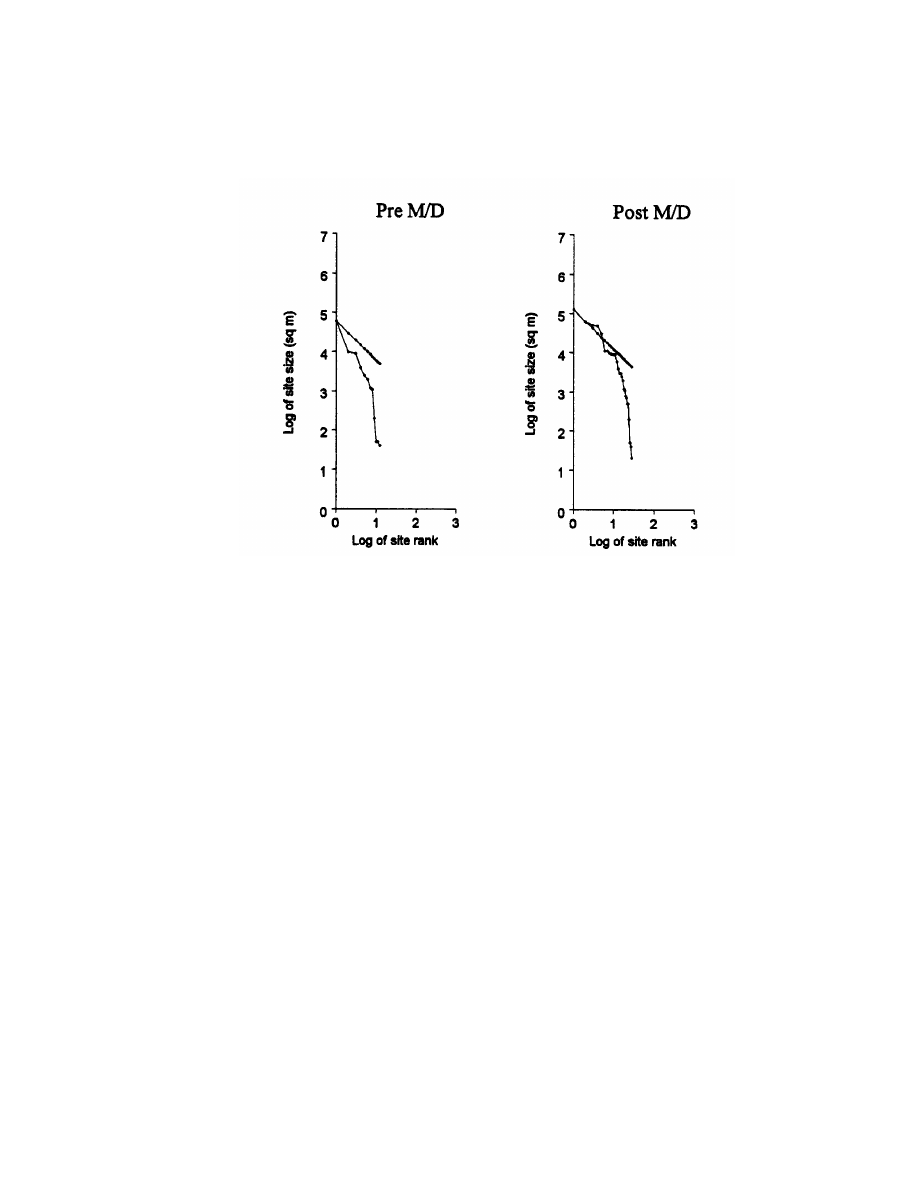
128
Chapter 5
Figure 5.14. Pre- and post-Mfecane/Difaqane rank-size curves for Swaziland.
surplus is concentrated in a few entrepots outside the sample area
(Johnson 1980; Paynter 1982). Hirth (1978) has argued that dendritic
hinterlands are created by long-distance trade networks. Thus, the
pre-Mfecane/Difaqane Swaziland rank-size curves are dissimilar
from Zululand in their absence of any large and medium sites and an
abundance of sites smaller than expected.
The later Swaziland rank-size curve is double convex, incor-
porating elements of rank-size primacy in its upper-size range and
convexity in its lower range. The social process would be much like
that suggested in the discussion of Zululand, namely, after the
Mfecane/Difaqane, Swaziland was participating in a two-tier settle-
ment system, such as is found in some colonial situations. These
curves are not in accordance with the Settler Model's expected convex
curves.
The Eastern Transvaal
The early eastern Transvaal distribution is double convex in its
upper ranges with large and medium sites slightly larger than ex-
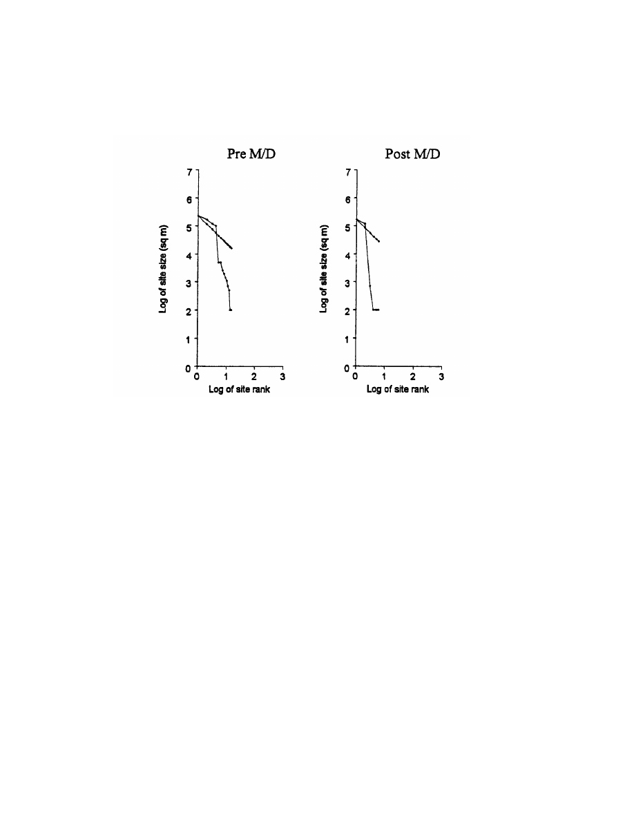
Using Archaeology to Study the Processes of the Mfecane/Difaqane
129
Figure 6.16. Pre- and post-Mfecane/Difaqane rank-size curves for eastern Transvaal.
pected and small sites much smaller than expected (Fig. 5.15). This
rank-size curve is also different from those curves predicted by the
Settler Model.
The rank-size curve for the later eastern Transvaal is also double
convex, then drops off and then becomes convex. Thus both eastern
Transvaal rank-size distributions resemble the late rank-size curves
for Zululand and Swaziland; all are double convex. Here again, the
predicted rank-size distributions from the Settler Model do not match
the observed curves.
Western Transvaal
The curve for the early western Transvaal is slightly concave
with large and medium sites slightly smaller than expected, and
small settlements much smaller than expected (Fig. 5.16). This distri-
bution does not fit the expected log-linear-to-convex curves proposed
by the Settler Model.
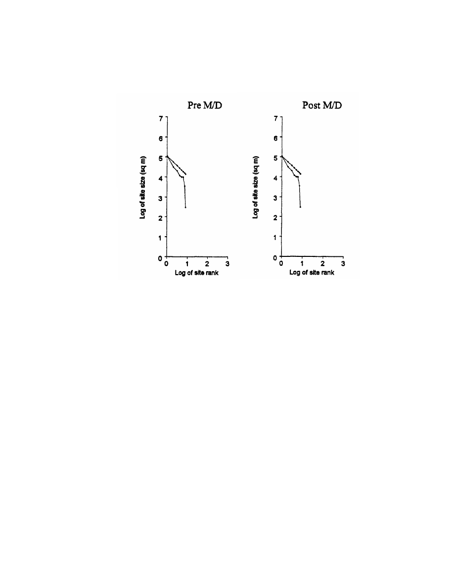
130
Chapter 5
Figure 5.16. Pre-
and post-Mfecane/Difaqane rank-size curves for western Trans-
vaal.
The later distribution for the western Transvaal is markedly
concave, with only one large site. The small sites are smaller than
expected. The western Transvaal curves are the first post-Mfecane/
Difaqane sites thus far not to have any double convex distributions.
With the exception of a slightly greater size difference between post-
Mfecane/Difaqane expected and observed sites, the late distribution
closely resembles the earlier one. These rank-size curves are not
convex as predicted by the Settler Model.
The Free State
Early Free State settlements exhibit regional primacy charac-
terized by a precipitous concave curve, with only one large site and
all small sites significantly smaller than expected (Fig. 5.17). Kelly
(1976) has suggested that dendritic systems exhibit large numbers of
low-level places oriented toward one higher place and a concentration

Using Archaeology to Study the Processes of the Mfecane/Difaqane
131
Figure 5.17. Pre- and post-Mfecane/Difaqane rank-size curves for Free State.
of elites in the higher level place. This appears to be the situation in
the early Free State. Once again, the rank-size distributions do not
fit the Settler Model predictions.
In accordance with the Settler Model, the later Free State sites
produce a convex distribution with all sites larger than expected.
This rank-size curve is assumed to indicate the region’s peripheral
relation to Zululand.
BEYOND THE HINTERLANDS
In recognizing the need to look beyond the hinterlands, all sites
in southeast Africa were combined. Johnson (1977, 498) has cau-
tioned that the larger the scale, the greater the probability for various
stochastic processes to affect the rank-size curves. The rank-size
curve for southeast Africa should be convex in both periods because
we are most likely compounding many settlement systems. Instead,

132
Chapter 5
the pre-Mfecane/Difaqane rank-size curve for southeastern Africa is
concave. As sites decrease in size, they become increasingly smaller
than expected. The post-Mfecane/Difaqane rank-size distribution for
southeastern Africa produced a more log-linear distribution with
larger settlements lying along the linear rank-size line, whereas
smaller sites show lower limb falloff and are smaller than predicted.
Very complex settlement processes are clearly happening in post-
fifteenth-century southeastern Africa, and the analysis points to
effects beyond the regions and indeed beyond the scale of south-
eastern Africa. Throughout southeastern Africa, the pre-Mfecane/
Difaqane period was marked, to varying degrees, by concave rank-
size patterning, patterns of relatively few large places and many
small places. This was the case in every region investigated with the
exception of the eastern Transvaal, which had a double-convex pat-
tern. Post-Mfecane/Difaqane patterns show a more complex situation-
Zululand, Swaziland, and the eastern Transvaal show double-convex
patterning, whereas the western Transvaal is concave, and the Free
State appears convex.
When the entire region of southeastern Africa is studied, instead
of exhibiting the extreme convexity expectable of pooling indepen-
dent systems, it actually looks as if southeastern Africa is a single
operation-with a concave pattern early on-as in the case of early
colonialism-and a log-linear distribution later for larger sites and
an increasingly concave pattern as sites become smaller-as the
region becomes a functioning system in the larger global political
economy with more mature colonialism (Fig. 5.18).
All these patterns indicate the effects of large-scale processes,
even in the pre-Mfecane/Difaqane period, processes certainly larger
than any of the individual regions and beyond the scale of south-
eastern Africa. These patterns point out the involvement of Euro-
peans in state formation in southeastern Africa, yet leave open the
issue of the nature of that involvement. Is trade for prestige goods
in the early period driving state formation?
CONCLUSIONS
My analyses suggest that the standard model is wrong, that the
various proposed “explanations” of the Mfecane/Difaqane are all
moot—what they attempt to explain is not what actually happened.
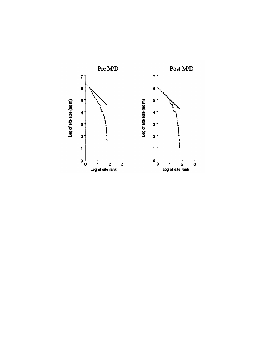
Using Archaeology to Study the Processes of the Mfecane/Difaqane
133
Figure 5.18. Pre- and post-Mfecane/Difaqane rank-size curves for southeastern Af-
rica combined.
Pre-Mfecane/Difaqane primary producer settlements did not all ex-
hibit “typical central cattle patterns,” nor were they characterized by
material culture forms indicative of their mode of production (i.e.,
stone tools associated with gatherer-hunters, pots with agropastoral-
ists, etc.). For example, OFD1, the largest site in the sample, had
ritual paraphernelia, elite burials, an elite culling pattern, and pas-
troforaging material culture. This anomalous site does not fit the
standard Settler Model.
Second, landscape diversity was not always associated with geo-
graphic regions or ecological characteristics. For instance, the envi-
ronmentally poor herding area of the eastern Transvaal has the most
animal units for both periods. The presence of large mineral and
iron-production sites and their association with European goods and
elite cattle patterns do not fit the settler version models. These
observed site types are better explained by a hypothesis based on pre-

134
Chapter 5
Mfecane/Difaqane African-European trade relations. Finally, royal
residences, particularly those in Zululand, do not fit the settler ver-
sion model until the later periods.
The emergence of the Zulu state and the ensuing Mfecane/
Difaqane has been the object of study by many different scholars of
many different disciplines for more than fifty years, yet the archae-
ological data are remarkably incomplete. The comparison of the ar-
chaeological data, although fragmentary, with the Settler Model and
with some of the ethnohistorical single-variable hypotheses seems to
better explain the relevant processes of demography and external
trade in a number of ways. Although circumstantial evidence strongly
suggests post-Mfecane/Difaqane conflictual relations, the exact rea-
sons for this conflict in terms of the captive- and cattle-raiding hy-
pothesis cannot adequately be addressed with the present data. In
Chapter 6, I discuss possibilities for future research that might shed
light on this particular explanation.
Both the ethnohistorical and population density analyses showed
that only after Zulu state emergence did population and settlement
size and density in Zululand increase along with the number of royal
residences. Later population increased 33 percent in Zululand,
Swaziland, and the western Transvaal and decreased 34 percent in
the Free State and the eastern Transvaal. I suspect that this inverse
relation may reflect increasing demographic densities resulting from
population relocation. Furthermore, the eastern Transvaal and the
Free-State had the largest early sites in the entire sample, both of
which were involved in exchange networks with Europeans at De-
lagoa Bay and the Cape frontier and were abandoned after the eigh-
teenth century.
The question of autonomous or interdependent polities and types
of interaction like trade processes was investigated by analyzing the
archaeological distribution of European trade goods, especially glass
beads. Zululand had no European goods in earlier sites and only one
later-period royal residence with glass beads. The Free State and the
eastern Transvaal had the most sites with European goods for both
periods. Only later did Free State royal residences contain more glass
beads than did eastern Transvaal mineral production sites, and Free
State forts were third. Indeed, during the later period, the Free State
fort is the only site with “abundant” glass beads. Thus external
relations were most likely at work in the early Free State and the
eastern Transvaal and only later in Zululand.

Using Archaeology to Study the Processes of the Mfecane/Difaqane
135
Zululand
Early Zululand’s primate curve deviation indicated that both
large and small settlements were smaller than expected. Although
Zululand’s largest site was an iron-production site, larger mineral
and iron-production sites existed outside Zululand in the eastern
Transvaal and the Free State. This could suggest less stratified social
relations and iron production for local markets in Zululand. Further-
more, the only early Zululand site with an elite cattle-culling pattern
is a military site, whereas the two royal residences had primary
producer-culling patterns.
Later Zululand is described by a double convex curve, with large
sites larger and small sites smaller than expected and with more
medium-size sites. All but the largest iron-production site are royal
residences, two of which had elite cattle patterns. I argue that the
double convex curve is associated with colonial situations and quite
possibly with those of the early stages of state formation. The curve
indicates that either “independent” or subordinate settlement sys-
tems are being sampled. The cattle patterns suggest that the defen-
sive site was continuously occupied by higher-status individuals who
felt a need for protection.
The central cattle enclosure sizes at royal residences in Zulu-
land, along with the number of cattle penned, increased dramatically
during the later periods. The increased site sizes may indicate courts.
Thus, not until after the emergence of the Zulu state did elite culling
patterns and increases in herd size appear at royal residences in
Zululand.
Swaziland
Swaziland’s early rank-size curve indicates involvement in a
possibly long-distance-trade-related larger system outside the sam-
ple area. The later Swaziland curve could be interpreted as related to
more centralized integration of large and medium sites and more
pronounced ruralism reflecting the dismantling of the old system.
Although mean central enclosure sizes in Swaziland became larger
through time (591 AUs pre-Mfecane/Difaqane and 677 AUs post-
Mfecane/Difaqane), the large central enclosures at royal residences
got smaller. These results, coupled with the fact that the total num-
ber of AUs in Swaziland increased only slightly, suggest that cattle

136
Chapter 5
were probably removed from royal residences and dispersed into
other locations. Finally, in terms of European trade goods, Swaziland
follows a Zulu pattern of none to some. This suggests that Swaziland,
not unlike Zululand, became engaged in international trade net-
works only after the Mfecane/Difaqane.
Eastern Transvaal
The eastern Transvaal rank-size curves for both early and late
periods are double convex for both periods and resemble those of
later Zululand. Elite herd profiles in the early eastern Transvaal are
found at one royal residence and two mineral-production sites. The
only later site with an elite pattern is a large mineral-producing
complex with enclosures greater than 100 meters in diameter. Thus,
despite the inhospitable environment for cattle herding, far more
cattle were kept here during both periods than in any other area and
period. It seems reasonable to suppose that eastern Transvaal was
going through trade-induced state formation during the early period,
possibly a trade concentrating on beef. However, the whole state-
formation process fell apart, in part from competition from the Zulu
and in part from the withdrawal of European connections or from the
intensification of European slaving.
Western Transvaal
The western Transvaal curves remained primate through time
but lost 50 percent of their sites and all but one central enclosure.
This suggests that cattle were no longer kept in this region, indicat-
ing cattle loss, dispersion, and/or site abandonment. Two military
sites, one with an elite culling pattern and the other with a primary
producer pattern, were occupied during both periods. Here, too, elites
felt a need to be fortified during both periods.
Free State
The early Free State curve exhibits regional primacy like the late
western Transvaal and contains a fort, one iron-producing site, a
ritual site, and a royal residence, both royal residences have elite
culling patterns. Regional primacy has been argued to possibly reflect
the effects of long-distance trade processes. Indeed the Free State
has a significant number of European trade items, especially Euro-

Using Archaeology to Study the Processes of the Mfecane/Difaqane
137
pean weapons and horses. The early ritual site, the largest in the
entire sample, had evidence of conflict and was later abandoned. The
archaeological remains and assemblages are anomalous and indicate
that stratified pastroforagers had occupied this site.
The later Free State sites produced the only occurrence of a
convex pattern for the entire sample while losing 50 percent of their
sites. This pattern is consistent with my argument for a loss of power
in the Free State through time and is indicative of the later Free
State’s peripheral position. An iron-producing site that was occupied
during both periods goes from an elite to a primary producer-culling
pattern. This might suggest a loss of power for those residing at the
iron-production site. Cattle enclosures and total AUs in the Free
State got slightly larger through time but remained relatively stable.
The rank-size analysis indicates that fifteenth- through seven-
teenth- century rank-size curves for each area are all primate con-
cave curves, varying only in their degree of steepness, with the excep-
tion of that in the eastern Transvaal. This finding is interesting in
that it suggests that a state-formation process occurring in the east-
ern Transvaal got totally disrupted. Indeed, this is the most common
rank-size distribution for polities involved in colonialism.
Demographic patterns parallel these rank-size interpretations.
Through time, Swaziland and Zululand had the greatest increases in
their large sites; the eastern Transvaal lost 75 percent of smaller
sites, the western Transvaal lost 50 percent of all sites, and the Free
State lost 33 percent of small sites and all large and medium sites.
The later rank-size curves are more diverse. Zululand, Swazi-
land, and eastern Transvaal exhibit the same double-convex distri-
bution curves. Free State’s curve is convex, and western Transvaal’s
curve is concave. It seems reasonable to suggest that population
growth in Zululand and Swaziland was related to the marked popula-
tion declines in eastern and western Transvaal and the Free State.
Discerning what is driving these demographic shifts seems impor-
tant for understanding the organizational changes suggested by the
rank-size analyses. It is also reasonable to see the rapid growth in
Zululand and Swaziland as related to the decline in the Free State
and eastern and western Transvaal. Attention needs to be devoted to
the causes of these declines, instead of focusing exclusively on the
effects of population growth.
These analyses suggest historical processes at odds with those
proposed in the Settler Model. Instead of a series of self-contained
regions from which the state emerges in one, Zululand, which then

138
Chapter 5
sweeps out to peripheralize all the others, a more fractured account
seems required. For one, the pre-Mfecane/Difaqane interaction fields
were much larger than any of these self-contained regions, although
the exact nature of the relations in these fields is still obscure. For
another, similar processes seemed to be happening in Zululand and
Swaziland, processes suggestive of relations of imposed colonialism
and/or imperfect state formation. The eastern Transvaal seems to
have passed from a period of relative organization to one of imposed
colonialism or imperfect state formation. The western Transvaal
became increasingly peripheralized, and the Free State became very
marginalized and thoroughly internally disorganized.
I suggest that these findings are directly related to changing
power relations among southern African polities and their European
allies, revolving around the trade in African captives. For example,
Zululand and Swaziland are very similar with the exception that
Zululand seems to win the state-formation struggle. The eastern
Transvaal seems to stop being directly under the sway of European
trade, and its formerly organized polity disintegrates into indepen-
dent polities, possibly each raiding the other for captives or possibly
each being tied to different external sources of power. Something
very similar may be happening with the Free State, except that it is
even more shattered by captive raiding so that hierarchically orga-
nized polities of any size are missing.
Interpretations for the western Transvaal are more varied. The
western Transvaal could be a refugee area with a central place that
is either trying to exploit everyone or that shifts from being exploita-
tive to being defensive. The western Transvaal could also represent a
central place that is now thoroughly disconnected from the peasantry
or a central place that is a Zulu-Swazi dependency.
Now that I have shown discordance between the Settler Model
and the actual archaeological data, how might we investigate the
captive- and cattle-raiding hypothesis proposed above? In Chapter 6,
I present some material manifestations of the slavery hypothesis
from the archaeological record for southern Africa.

Toward an Archaeology
of Impact
6
SUMMARY OF THE RESULTS
Most historical research on southern Africa has uncritically accepted
the role of Zulu state formation in the Mfecane/Difaqane as the
most important political event in later south African history. The
Mfecane/Difaqane describes a cataclysmic event precipitated by Zulu
consolidation and expansion and involving the emergence of a num-
ber of other African military polities. There are several assumptions
underpinning this standard settler version of southern African his-
tory. The first implies that the near-genocidal warfare characterized
by cattle raiding, starvation, forced migrations, and terror was inter-
nally generated. Another assumption is that the black-on-black vio-
lence created African refugee communities seeking “asylum” among
European colonists and resulting in large tracts of depopulated areas
where Europeans settled. Most settler version theorists assume that
European involvement was minimal and consequently have omitted
European agents from the equation. They have focused instead on
increasing conflictual relations between traditional African rivalries
arising from demographic stress and ecological deterioration. Others
who concede European involvement highlight the commercial com-
petition between African polities for control of ivory and cattle ex-
ports at Delagoa Bay. The notion of an internal, Zulucentric, Mfecane/
Difaqane remains unchallenged.
My research and analysis suggest that the Settler Model of the
Mfecane/Difaqane is wrong: It has the wrong people in the wrong
places with the wrong political organization, and it incorrectly as-
sumes a lack of political/economic ties between regions (Table 6.1).
Why did we end up with this situation, and where do we go from here?
The reason we ended up with this situation is that people be-
lieved the settler version because it served European colonial inter-
ests and the interests of European-sanctioned African elites. The
Europeans, for example, had an interest in obscuring the role and
139

Table 6.1. Table for Southeastern African Changes from Pre-
to Post-Mfecane/Difaqane
Population
Social
Number
of
cattle Rank
Trade
size hierarchy
enclosures size European goods
Site
EXP
Obs
EXP
Obs
EXP
Obs
EXP
Obs
EXP
Obs
Zulu
Increase
Increase
Increase
Increase
Increase
Decrease
LL to cave
Cave to DC
Increase
Increase
Swazi
Same
Increase
Increase
Same
Increase
Decrease
LL to vex
Cave to DC
None same
Increase
Et
Increase
Decrease
Same
Decrease
Decrease
Increase
LL to
LL
DC to DC
Decrease
Decrease
Wt
Increase
Decrease
Same
Same
Increase
Decrease
LL to vex
Cave to cave
None same
Same
Fs
Increase
Decrease
Increase
Decrease
Decrease
Decrease
Vex
to
vex
Cave to vex
None same
Decrease
SEA
Increase
Increase
Increase
Decrease
Increase
Decrease
Vex
to
vex
Cave to LL
Increase
Decrease
Note: Cave = Concave, DC = Double Convex, LL = Log-linear, Vex = Convex refer to the type of rank-size curves. Expected = Exp; Observed = Obs.
140 Chapter 6

Toward an Archaeology of Impact
141
magnitude of slaving and the effects of slaving on African popula-
tions. The post-1820 African elites had an interest in legitimizing
their own superordinate status and therefore had reason to disguise
the nature of pre-1820 polities. Where do we go from here? We start by
using archaeology to bypass the biases of the ethnohistorical and
documentary record. Archaeology is the way to find out what pre-
Mfecane/Difaqane societies were like and how both European and
African polities were inter-related.
Cobbing’s (1988) provocative reformulation of the Mfecane/
Difaqane constructs a compelling case for considering the role of
European trade in African captives, which stimulated internal con-
flicts and the militarization of African polities throughout southern
Africa. This trade was meant to meet the internal and external labor
demands of European colonists and the internal demands of their
African agents. Cobbing also demonstrates how and why the stan-
dard settler version, which vilifies the Zulu, functions in the modern
South African political economy by masking the role of whites in
destabilizing African polities and by placing the onus of responsibil-
ity for the destruction of African societies on the Africans themselves.
To investigate Cobbing’s hypothesis, we must look at the histori-
cal documents, oral texts, and archaeological record beyond Zululand
and consider the full range of both African and European dynamics in
southern Africa. Essential to this endeavor is comprehending differ-
ences and similarities between African forms of incorporation and
European notions of slavery.
According to Hall (1990,1461, African captives who lost all kin-
ship ties went on to “become members of the conquerors’ armies and
households-in a word, ‘slaves.’” He correctly emphasizes the wider
application of the term slavery to distinguish armies used by Prazeros
(land titles granted by the Portuguese king, making former rene-
gades “official” landholders and loyal Portuguese subjects) from Afri-
can captives used for domestic and plantation labor in European
colonies (Hall 1990, 129-32).Although he does not specifically say
that “slavery” was a factor south of the Limpopo, he does call atten-
tion to the simultaneous occurrence of Zulu state formation, Mfecane/
Difaqane, and establishment of the trade in African captives between
African groups throughout the subcontinent.
He argues that African “slavery” was an extension of the pro-
cesses by which war captives were initially incorporated into African
states, evolving out of indigenous African systems of forced incor-
poration. Hall (1990,132) states that the definitive characteristic was
the manner of capture and sale, which resulted in detaching people
from their communities.

142
Chapter 6
Many southern African polities yielded their autonomy in pro-
duction and distribution to more powerful groups. However, this
reality raises several questions that must be addressed. How repres-
sive were the means, and how long lasting and how socially extensive
were their loss of power? Did the loss of power extend to all segments
of the society? Finally, what were the effects on other communities
not incorporated by these emergent states? Thus, can precolonial
African social relationships between captors and captives legiti-
mately be called “slavery” and equated with “racial commodity slav-
ery” as defined and described below?
RACIAL COMMODITY SLAVERY
AND AFRICAN INCORPORATION
Slavery can be heuristically seen as a range of points on a contin-
uum of labor relations. Both the conditions of coerced labor and the
means used to procure it have been shown to be highly variable and
historically specific in Africa and elsewhere (Etherington 1991b, 156;
Meillassoux 1986). Hence, although racial commodity slavery and
African incorporation involved subservience and exploitation of labor
and its products, there were qualitative differences worthy of note.
Variable African Labor Relations
African incorporation and exclusion yielded different ways by
which wealth generated from expropriated labor was transformed
into elite political and economic power through accumulation and the
attraction of followers.
Harries (1981, 320) points to the myriad types of incorporation
known ethnographically and historically in southern Africa such as
ransomed hostages, volunteers, and concubines (i.e., daughters given
to elites by fathers as tribute or taxes for material assistance and
protection during upheavals and insecurity). Royal daughters from
concubines produced agricultural surplus and commanded inflated
bride wealth in addition to providing lineage members. Mbatha
(1960,18 and 66-69)refers to persons reared from childhood by a clan
not their own as “affiliate clansmen.” He explains that this status
entails mutual obligations and involves individuals and groups (war
captives, commoners, refugees, etc.) who are forced to submit them-
selves and/or their families into service to a king, chief, or headman

Toward an Archaeology of Impact
143
who sponsors them for land. Captive raiding also provided a rapid
means of acquiring labor, lineage descendants, and profits. Elite used
captives to enlarge the size of the superordinate groups’ lineages with
socially and economically dependent subordinates without kin, home-
stead affiliation, or territorial ties. Thus captive raiding furnished a
process by which reciprocal sets of kinship and marriage obligations
could be avoided (Cohen 1967, 44; Kopytoff and Miers 1977, in Hall
1990, 132-33; Harries 1981, 314; Meillassoux 1986).
The Zulu state was characterized by processes of expansion, sub-
ordinate incorporation, displacement, and consolidation of an assort-
ment of local and regional eighteenth-century polities (Slater 1976; J.
Wright 1990). Zulu incorporation used kinship ideology to create
pejorative ethnic identities by differentiating elite from commoners
(Hamilton and Wright 1984, 7-9; Wright and Hamilton 1996).
Yet African captives traded to other Africans, although relegated
to the lowest social positions in a captor’s society, had varying degrees
of social mobility, often depending on their manner of recruitment.
For instance, most captives had some expectable political and eco-
nomic rights such as protection against outsiders, ability to obtain
marriage partners, access to the means of production, and some-
times, depending on their skills, an opportunity to earn an indepen-
dent compensation. They often became loyal and trusted political and
administrative appointees precisely because they had no outside kin
obligations.
Furthermore, one was not necessarily a “slave” for life. Captives
could be heirs, and many obtained positions of power and influence.
Captives could achieve higher status and acquire freedom during
their lifetime, through bravery in battle, skilled workmanship, and
loyal service or after a specified period when autonomy was granted
and the person was incorporated into the superordinate’s kin group
as a full-fledged member. In addition, one’s children did not neces-
sarily share a “kinless” fate. Often the rank of a captive’s offspring
was determined by the superodinate’s rank; certain captives’ off-
spring were sometimes ranked higher than those of noncaptives
(Cohen 1967, 45). Finally, captives remaining in Africa were often
able to sustain their own or similar African institutions, language,
customs, beliefs, and cultural practices. A captive could often run
away to a neighboring village as long as the old superordinate was
compensated by the new. Similarly, those captives traded to Euro-
pean colonists in Africa were reasonably familiar with the terrain
and often escaped to more friendly African polities.

144
Chapter 6
Racial Commodity Slavery
The nature of racial commodity slavery, on the other hand, ex-
cluded captives from rich interactions with others in society (Mintz
1978). On the basis of phenotype, language, and culture, captives
were afforded a permanent stigmatized social status, transmitted to
their descendants with little or no opportunity for acquiring freedom.
Moreover, these conspicuous attributes became justifications for Eu-
ropean racist disdain, inhumane treatment, and permanent use of
slaves as property. In addition, the use of firearms and violence to
obtain African captives for the European marketplace transformed
African communities into specialized captive-raiding states and
others resisting raiding. Globally, this traffic altered the political
economy of Africa while it created a tributary power relation between
Europe and Africa (Wolf 1982).
In most cases, Africans were transported to a completely differ-
ent cultural and environmental milieu too far from Africa for them to
return. These African captives were forced to create new cultural
forms of self-identity and survival. There were also “mixed” commu-
nities like the Griqua and Korana, who, despite rejection and abuse
by Europeans, were willing colonial agents. They adopted European
dress, religion, culture, and values. They also collaborated with Euro-
peans in hunting down escaped captives and raided Africans to pro-
vide captives and cattle for Europeans and themselves (Etherington
1991a).
In sum, all southeast African polities possessed a variety of
means for incorporation into and exclusion of individuals and groups
out of their societies. African incorporation sought to build kin
groups by incorporating kinless individuals. Racial commodity slav-
ery was expansive and based on a global division of labor rooted in an
ideology of racism. Its nineteenth-century escalation into African
polities drastically altered the nature of differential incorporation
and culminated in social marginality in militarized, heterogenous,
nationalized states. These states were themselves products of incor-
poration and amalgamation, some with the capability for sustained
coalescence and resistance.
As European penetration coalesced, members of some conquered
groups were enslaved by European frontier communities, and others
were variously incorporated into African societies. The increasing
physical and social separation of whites from their African labor force
facilitated a legally sanctioned class ideology of racism and segrega-

Toward an Archaeology of Impact
145
tion, which enabled greater elite control of a racially divided labor
pool. This process in southern Africa involved the political creation of
colonial-defined, externally imposed color categories of new racial
and ethnic identities of white inclusion and black exclusion.
More acquiescent African polities were given some internal au-
tonomy to reinforce the new racial and ethnic distinctions of colonial-
ism. Groups were identified, their identities transformed, elimi-
nated, assimilated, and co-opted as struggles on economic, political
and cultural fronts took shape (Paynter personal communication,
1994). Other Africans seized this opportunity to use these dichot-
omies to act independently of the colonizers to create sociocultural
and ideological structures of resistance in their quest for liberation.
African struggles over exclusion and incorporation were actively
contested. Because the ideological and physical separation proceeded
together, architectural trends accompanying the physical segrega-
tion should be reflected by particular artifact configurations or sym-
bols of cultural continuity similar to Patterson and Gailey’s (1987)
“archaisms” and by other spatial realms of colonial architecture,
material culture, and African cultural landscapes.
The Impact of Racial Commodity Slavery
Raiding for captives involved killing and capturing people, burn-
ing villages and fields, and confiscating livestock and grain stores.
These conditions effectively destroyed the agropastoral economic
base, fostering insecurity and driving many families from their his-
toric communities and into migrant labor, commodity production,
and military organization.
The sheer number of captives, even counting only those “legally”
traded, suggests that African societies suffered enormous population
losses, particularly of the younger, more productive members of soci-
ety, especially men. This had detrimental consequences for the age
pyramid and biological reproduction. It left many women without
men. The more that women outnumber men, the more vulnerable
women are to men. Hence communities with fewer fighters tended to
be vulnerable to attack. Captive raiding also severely transformed
gender relations and caused an expansion in the incidence of polyg-
amy (Cobbing 1988; Eltis 1987; Lovejoy 1983).
Social reproduction was drastically altered as African networks
of kinship and marriage, which had served as the traditional basis for
alliances, power, and authority, could now be circumvented by groups

146
Chapter 6
connected to Europeans and their agents. European weapons facili-
tated both the ability to exact tribute over wider areas by raw military
force and the ability to resist raiders. As captive and cattle raiding
replaced trading as the dominant form of economic activity, African
labor became worthless without military protection (Wilmsen 1989).
Racial commodity slavery was a brutal but effective means of accu-
mulating the necessary labor for global capitalism. The stigmatized
groups served capitalist accumulation by providing an available la-
bor pool for external plantations and internal colonies and by lower-
ing European wages at little cost to the colonial powers.
Finally, captive raiding generated an advancing colonial frontier
that violently seized land and dispersed African populations, thereby
providing huge depopulated areas on the peripheries of settlements
of Europeans and their agents and creating opportunities for more
European settlement and expansion.
REGIONAL LANDSCAPES AND ARTICULATING
MODES OF PRODUCTION
Marxist theory assumes that concepts like capitalist penetration
and resistance represent actual historical sets of social relations
yielding certain archaeological expectations dependent on how hy-
potheses are framed to include archaeological data. Such concepts
facilitate understanding of some distinctions not readily apparent
from the archaeological data alone, distinctions that tend to be ob-
scured in the more generalized models (Hall 1990, 64).
Althusser and Balibar (1971) have argued that colonial areas
were social formations characterized by “articulating modes of pro-
duction’’ where the capitalist and noncapitalist modes of production
coexisted contradictorily in conflict and acquiescence. Southern Afri-
can landscapes were dynamic and operated at different scales; that
is, they constituted regions or parts of regions that varied considera-
bly in function, size, extent, duration, and interaction from social
formations outside Africa.
The sixteenth-century Portuguese destruction of eastern African
coastal polities shattered the once-stable commercial relations be-
tween the coast and the interior and forced the collapse of Great
Zimbabwe and the emergence of the Torwa and Mutapa states to the
south. The new kingdoms had alliances with the Portuguese based at

Toward an Archaeology of Impact
147
Mozambique, who plundered local groups for captives and estab-
lished markets and hegemony over vast estates (Hall 1990,130). The
demand for African labor collapsed local lineages and made access to
coercion and destruction the basis for alliances and power.
Farther south, powerful eastern Transvaal polities that had been
heavily engaged in metal trade with African interior groups for hun-
dreds of years became involved in commercial relations with Euro-
peans at Delagoa Bay. During the seventeenth century, European
competition to control ivory resulted in African-European conflictual
relations and alliances in and around Delagoa Bay. By the mid-
seventeenth century, ivory sources were coming primarily from the
areas south of Delagoa Bay (Hedges 1978). By the eighteenth century,
the Mthetwa-Zulu were engaged in regional elite commercial rela-
tions, initially involving commodities of little value in their own
economies. For instance, ivory was exported for commodities given
value by their rarity, These exclusive wealth forms were essential to
the emergent ruling class and replaced cattle accumulation as the
principal means for signifying wealth, power, and authority.
The nineteenth century witnessed an intensification of livestock
and African captive raiding throughout southern Africa. For in-
stance, Griqua captive raiders and cattle raiders attacked Xhosa
villages in 1805, Zulu homesteads in 1821, and Ndebele communities
in 1828 and displaced Free State Sotho-Tswana communities by the
1820-30s (Cobbing 1988). These early decades of the nineteenth
century also saw Boers invading and occupying the southern high-
veld and the Free State and forming the South African Republic in
1836 (Etherington 1991a).
These events suggest looking beyond declining access to exotic
commodities by the Zulu as the cause of the Mfecane/Difaqane. Hall
(1990, 125) points out that although the Zulu and Xhosa polities
generally prevented fissioning and at times successfully contested
European colonial penetration, there is little evidence for class for-
mation like that found at Great Zimbabwe.
It is possible that the transition to military polities and from
useless to useful exports like cattle and people during the nineteenth
century was based on a demand for firepower. Unlike earlier wealth
forms that maintained and lubricated ruling-class alliances, Euro-
pean weapons could be used by competing Africans and Europeans.
European hegemony was facilitated by providing collaborating Afri-
can polities with the advantages of firearms, horses, and alliances for

148
Chapter 6
augmenting their slave- and cattle-raiding capabilities, further accel-
erating and entrenching African dependence. European agents sought
to instigate and aggravate internal African rivalries and to deceive,
disrupt, and destabilize African polities (Cobbing 1988).
The plunder of African communities by Europeans and their
African agents, combined with European settler competition for land,
food, and labor resources, placed a premium on militarized polities.
This resulted in famine and displacement for those communities and
individuals without military protection. People were forced to move
into areas that were simultaneously part of their traditional home-
lands and part of the newly emerging landscapes perceived as margi-
nal by European settlers.
Thus the late-eighteenth-century rapid proliferation and coales-
cence of military polities was one manifestation of African resistance
to European penetration. These polities were forged of different Afri-
can people who superimposed firearms onto preexisting structures
like the Amabutho during the Mfecane/Difaqane.
Europeans transformed the landscapes they found with various
new forms of materials, like guns, forts, and horses. These material
cultural forms were manipulated by Europeans and Africans alike,
and African cultural landscapes became part of a specialized periph-
ery of a new larger totality, whose centers of gravity were elsewhere
and whose commercial activity was rooted in class-based commodity
production and consumer demands in Europe. The peripheralization
was based on the expropriation of indigenous raw materials, food
resources, land, and human labor for a colonial plantation economy
rooted in racial exclusion (Cruz-Uribe and Schrire 1991). From the
beginning, however, these local and global transformations engen-
dered forms of African resistance and contestation that must be
reflected in the material world and cultural landscapes of southern
Africa.
A COMPARATIVE ARCHAEOLOGICAL
LOOK AT SOUTHERN AFRICA
The results of looking at the archaeological data suggest that
ecological, demographic, and trade processes appear to have little
validity as monocausal explanations of the Mfecane/Difaqane. The
archaeological and ethnohistorical evidence reveals certain trends

Toward an Archaeology of Impact
149
that indicate that the historical processes responsible for the Mfecane/
Difaqane were much more complex and certainly involved Euro-
peans. Furthermore, this evidence indicates that processes affecting
southeastern Africa had effects in Zululand opposite to those in the
Free State and the eastern and western Transvaal. For example, all
demographic analyses point out that the post-eighteenth century
Zulu population was about 50 times larger than in the fifteenth
through eighteenth-centuries, with a 33 percent increase in the num-
ber of sites. These increases were associated with population de-
creases in the Free State and the eastern Transvaal and a corre-
sponding 34 percent decrease in the number of sites. A comparative
analysis of the Free State and eastern and western Transvaal with
Zululand reveals the inverse pattern more clearly.
The Free State shows no evidence of agropastoral settlement
until about
AD 1300 when numerous stone-walled livestock enclo-
sures and settlement units appear (Hall 1990). Maggs (1976a, 330)
has defined four types of Free State settlements based on different
architectural features and has tentatively identified specific groups
with each type.
The earliest sites are the southwestern, fourteenth- to nineteenth-
century Type R settlements along the Riet River. Larger Type R
settlement sites had rock engravings, rock gongs, and stone-lined
burial pits with exotic grave goods. This circumstantial evidence
suggests involvement in European commercial relations and differ-
ential social status. Yet wild game, lithics, and undecorated grass-
tempered pottery suggest pastroforagers. The evidence of at least one
burnt dwelling and the site’s eighteenth-century abandonment could
suggest changing regional power relations.
Both the late-fifteenth-century northeastern Free State Type N
sites and the eastern Type V sites date from the sixteenth century.
Type N settlement units are characterized by surrounding perimeter
walls enclosing the entire settlement unit and are generally situated
at higher elevations (Hall 1990, 49-50;Maggs 1976a, 321-22). Ear-
lier sites are larger, more dispersed than later sites, and concentrated
on hilltops (Maggs 1971, 1976a, 1976b). At least one of these Type N
sites, Klipriversberg, became fortified and contained European com-
modities.
During the late sixteenth century, many new Type V settle-
ments were constructed between and superimposed onto older Type
Ns that continued to be occupied or reoccupied. By the early seven-

150
Chapter 6
teenth century, Type V sites became the most widely distributed type
on the southern highveld, and by the eighteenth century they were
abandoned.
Makgwareng, a late-eighteenth through early-nineteenth-century
Type V site, contained ostrich eggshell beads, iron spear points, and
cattle and horse remains. The settlement seems to have been “sud-
denly and violently abandoned” as evidenced by the remains of sev-
eral stores of iron tools, clusters of spear points around a homestead
entrance, and a human jaw bone in the cattle enclosure entrance
(Hall 1990).
Type Z sites are densely packed settlements in the drier north-
western Free State and date from the late fifteenth through the
nineteenth centuries. During the sixteenth and seventeenth centu-
ries, new Type Zs emerge between older ones.
In sum, southern highveld settlements began to aggregate after
the fifteenth century, exhibiting differences between elite north-
western sites with European commodities and primary producer
eastern sites. There were four early sites with elite cattle-culling
patterns: a fort, an iron-producing site, and two royal residences. The
one iron-producing site that remained occupied during both periods
changed from an elite to a primary producer-culling pattern. This
might suggest a loss of power for those residing at the iron-production
site. Furthermore, most elite sites were abandoned by the eighteenth
century, and the number of forts increased.
The archaeological evidence of regional primacy and greater
kinds and amounts of European goods, especially European weapons
and horses, tends to support the documentary record that Free State
polities were involved in long-distance exchange relations with Euro-
peans at the Cape, both before and after the Mfecane/Difaqane.
Before the Mfecane/Difaqane, eastern Transvaal production sites
contain the most glass beads. After the Mfecane/Difaqane, Free State
royal residences and a fort with “abundant” amounts of glass beads
contained the most beads. Free State faunal assemblages exhibit
mostly primary producer cattle-culling patterns with wild game pro-
viding a significant portion of the diets (Maggs 1975,449-54 in Plug
and Brown 1982, 120).
Zululand settlement transformations are the opposite of those in
the Free State. Archaeological settlement studies from Zululand
indicate a large-scale expansion of Type B stone-walled settlements
into the southeastern grasslands near dolerite outcrops between the

Toward an Archaeology of Impact
151
sixteenth and eighteenth centuries. These areas were unoccupied by
agropastoralists earlier (Hall 1981; Hall and Maggs 1979). Type B
sites are architecturally dissimilar to traditional “central cattle pat-
tern” settlements and exhibit primary producer cattle-culling pat-
terns and an absence of European commodities (Hall 1984c, 1990;
Hall and Mack 1983).
My analyses show more royal residences and military sites in
Zululand than in any other region; two of three early royal residences
in Zululand had primary producer cattle-culling patterns. A fortified
Type B site had an elite cattle-culling pattern and evidence of earth-
work ditches and sinuous cattle passages protecting against cattle
raiding. These early-period patterns suggest the continued impor-
tance of military individuals and a concern with cattle raiding in
Zululand.
The later Zululand sites consisted of two royal residences with elite
cattle-culling patterns. These later royal residences yield older cattle
(for military shields?) and a differential distribution of higher-
and lower-status body parts (Plug and Brown 1982; Plug and Roodt
1990). Central enclosure sizes and presumably the number of cattle
increased significantly during the later periods at the royal resi-
dences. The increasing court size and increasing numbers of cattle
suggest the growing importance of royal residences after the eigh-
teenth century.
The largest sites for both periods were iron-producing sites. The
number of furnaces and by implication the demand for iron weapons
and tools increased until the late nineteenth century. With the onset
of colonialism, these sites were abandoned. This circumstantial evi-
dence could reflect iron production for local markets before the
Mfecane/Difaqane and greater local demand and regional markets
like the Free State after the eighteenth century. Oral traditions
indicate that Free State populations acquired iron implements from
Zululand iron-producing sources before the early decades of the nine-
teenth century (Maggs 1982, 1984, 202).
Thus, substantial evidence for conflictual relations before the
Mfecane/Difaqane can be found in the continuous presence of mili-
tary elite in Zululand with elite cattle-culling patterns at fortified
sites. Fortifications increase in Zululand after the eighteenth century.
A similar inverted relation also existed between Zululand and the
eastern Transvaal through time. The eastern Transvaal had the most
metallurgical and primary producer settlements and despite its poor

152
Chapter 6
agropastoral environment, more cattle during both periods than any
other area. The cattle were primarily at large specialized sites. Herd
profiles in the early eastern Transvaal sites are mostly elite cattle-
culling patterns from a royal residence and two production sites. Pre-
eighteenth-century metallurgical and production sites are found in
the eastern Transvaal, and evidence of commercial relations with
Europeans is found by the early eighteenth century. The only later
site is the large production complex that continues to exhibit an elite
cattle-culling pattern.
By the late eighteenth century, large metallurgical sites become
larger, fortified, and defensively situated. Large settlements become
more architecturally complex with cattle tracts, terracing, and differ-
ent size livestock enclosures and are surrounded by smaller sites at
lower elevations.
In summary, the archaeological evidence suggests that the east-
ern Transvaal and Free State sites show increasing evidence of set-
tlement aggregation, social stratification, conflictual relations, and
European commercial relations after the fifteenth century. By the
eighteenth century these areas show evidence of fortification, elite
and primary producer-site abandonment, and reduction or ag-
glomeration of cattle at large specialized sites. Taken together, these
patterns suggest conflictual relations and population dispersion in
regions on the expanding European colonial frontier by the eigh-
teenth century.
The documentary sources and oral texts speak of the dispersal of
Free State and Transvaal groups sometime after the mid-eighteenth
century. Not until the early decades of the nineteenth century did
these communities begin to aggregate in these areas as people began
to vacate their towns. Huffman (1984) attributes these transforma-
tions to events in Zululand in particular, not to European intrusion.
As I have stressed, the archaeological evidence from Zululand
shows increases in precisely those categories that decreased in the
Free State and eastern Transvaal. I contend that these patterns
mean that people found life in those areas near European settlements
dangerous and moved into Zululand, or that they were forcibly incor-
porated into the Zulu state as regional power shifted to Zululand
after the start of the nineteenth century.
Besides the accumulation of wealth forms signifying power and
authority, long-distance processes also involved access to European
firepower, protection, and force. The analysis suggests that Zululand
exhibited no European artifacts until after the Mfecane/Difaqane.

Toward an
Archaeology
of
Impact
1
53
The eastern and western Transvaal and the Free State showed com-
mercial contact with Europeans before the Mfecane/Difaqane.
Whatever the conditions in southeastern Africa during the pre-
and post-Mfecane/Difaqane, they had the opposite effects on commu-
nities in Zululand, Swaziland, and western Transvaal and on those in
the Free State and eastern Transvaal. Although evidence for conflic-
tual relations is undeniable, the exact causes of this conflict cannot be
definitively addressed with the present data.
Nonetheless, all analyses and results suggest that the Mfecane/
Difaqane as traditionally characterized in settler history is inade-
quate in explaining the post-fifteenth-century transformation in
southern Africa. The transformation is better understood as a result
of more complex global processes involving Europeans.
Last, I have argued that the context of colonialism and global
power relations has resulted in bias not only in the historical record
but also in the archaeological questions about the Mfecane/Difaqane.
This bias becomes most apparent when identifying and formulating
hypotheses accounting for the discrepancies between the archaeo-
logical and documentary records. As suggested by Leone and Potter
(e.g., 1988a, 1988b) “ambiguities” in the different lines of evidence are
places where power lies-power that has resulted in telling histones
that affect social relations today. If this is the case, then how can we
go about finding out what happened? What research is necessary to
better understand post-fifteenth-century southern Africa?
PROSPECTS FOR AN ARCHAEOLOGY OF IMPACT
This section is concerned with the ways in which historical ar-
chaeology can contribute to the theoretical and historical discourses
about questions of capitalist penetration, colonialism, domination,
and resistance in post-fifteenth-century southern Africa. I present
some possibilities for an agenda for subsequent research topics with
questions and archaeological implications based on certain data
deemed important for the different interpretations. My goal is to
present different ways that anthropologists might use archaeological
methods for collecting, interpreting, and analyzing data to contribute
to a better understanding of issues of power. I use questions from the
contrastive case, that of African captive and cattle raiding, to direct
future research strategies that can shed more light on this particular
historical case.

154
Chapter 6
Long-Distance Processes: Core-Periphery Relations
Although core-periphery relations leave archaeological traces
that can affect data, there have been relatively few archaeological
studies of these relations. This is due partly to the difficulty in
situating such studies in an archaeological survey of comparatively
small areas and partly to problems with recognition. One must look
for such landscapes to recognize them; one must be cognizant that
one is looking at only a sector of a global system.
Two expected theoretical configurations of peripheral-colonial
cultural landscapes are dendritic patterns and regional primate pat-
terns (Blanton 1976; Crumley 1976; Johnson 1977,1982; Kelly 1976;
Paynter 1982; Smith 1976a, 1976b; Wright and Kus 1979).
Several areas exhibited characteristics of dendritic systems and
regional primacy. Early and late Swaziland and late western Trans-
vaal sites show larger numbers of smaller sites oriented toward a
significantly larger elite site. Only early Free State sites had evidence
for long-distance trade networks. This could indicate the exclusion of
larger African or European sites, in southern Mozambique, Cape
frontiers, or elsewhere. These patterns beg the question of the loca-
tion of these entrepots.
Archaeological surveys and/or excavations of African and Euro-
pean entrepots, near Delagoa Bay, Natal, and the like, straddling
coastal exchange corridors, can provide opportunities for data collec-
tion for studying processes of European penetration. Archaeological
research in Natal has focused on African sites and has ignored early
colonial sites like trading posts, missions, and European farmsteads,
and little has been done in the Delagoa Bay area.
Future research must also examine European settlements and
structures at these entrepots and elsewhere. My settlement maps
indicate an increasing proliferation of European forts, initially lo-
cated in coastal communities and later inland. This pattern raises
questions about the spatial distribution of other European settle-
ment types.
Resistance and Contestation
African captive and cattle raiding involved both local and exter-
nal resistance and contestation. A Eurocentric perception of enslave-
ment and domination masks the faces and muffles the voices of
resistance by active social agents. Archaeological considerations of

Toward an Archaeology of Impact
155
how landscapes, identities, and objects were transformed to contest
Western penetration and to organize resistance have generally been
excluded from explanations of the African past.
Resistance and contestation are always more than a collection of
individual acts. They range from open defiance and armed confronta-
tion to passive resistance to other forms of noncooperation that limits
and impedes domination. They involve minor acts of sabotage to
harass captors and colonists like theft, feigning illness, work slow-
downs, deception, desertion, evasion of census/taxation, purposeful
laziness (i.e, “shucking and jiving”), and ineptitude (Davis 1971; Pat-
terson and Gailey 1987; Scott 1990). They also entail major acts like
cattle theft, burnings, fighting, poisonings, escaping, providing ha-
vens for escaped captives, and, of course, insurrection, insurgency,
and armed warfare. These conscious strategies send unequivocal
messages about African dissatisfaction and willingness and ability to
resist.
The presence of European and African forts themselves, along
with the looting of European towns and farmsteads, attests to the
hostile environment of the colonial encounter. I contend that the
proliferation of military polities is reflective of resistance to Western
incursion as warfare reinforced the leadership and promoted spe-
cialized military groups.
Armed Confrontation
Armed confrontation and military specialization are key charac-
teristics globally defining the colonial encounter. Armed confronta-
tion in southern Africa occurred between Africans over forced incor-
poration and between Africans and Europeans over colonization. The
archaeological evidence indicates that fortified African settlements,
conflictual relations, and European contact were manifested long
before the Mfecane/Difaqane in areas outside Zululand, and only in
post-Mfecane/Difaqane Zululand are sites large military towns with
specialized areas for royalty (Parkington and Cronin 1979; Plug and
Roodt 1990; Watson and Watson 1990).
Biohistorical evidence of armed confrontation includes data from
burials and battlefields, revealing African and European individuals
injured or slain in combat from gunshots or spear thrusts. One must
remember that both Africans and Europeans used firearms, and
there were many intra-European conflicts on the frontier as well. I
know of no study of battlefields or African skeletal remains concerned

156
Chapter 6
with those questions. A review or reanalysis of published materials
on burials with such questions in mind should prove productive.
Firearms and Spears
Theoretically, because all Africans, including captive and cattle
raiders, were ultimately supplied by mainland European gun makers,
we should be able to use weapons and related material objects to
relatively date archaeological sites and as reflections of armed con-
flict. European military uniform paraphernalia, horses, and horse
and wagon equipment could also signify the sites of European agents.
Locally made gun flints and arms repairs could indicate resistance
and should be sought in sites occupied by African populations (Schrire
and Deacon 1989, 109).
The eastern and western Transvaal and Free State have evi-
dence of these categories of European goods during both periods.
Evers (1979, 34) recovered pieces of muzzle-loading guns from the
Mapoch site, a stone-walled African fort destroyed by Europeans in
1883 in the eastern Transvaal. Kgopolwe Hill, a nineteenth-century
royal village, yielded military uniform buttons and a gun muzzle and
barrel (Evers and Van der Merwe 1987, 90-91), and Oudepost 1 has
yielded cannonballs, gun flints, and evidence of burning and sacking
by the Ju/’hoansi (Schrire 1988).
Despite the historically known frequency and scale of warfare,
archaeological excavations have so far recovered relatively few exam-
ples of European or African metal weaponry at sites in proportion to
the known historic incidence of warfare. The documentary record
indicates that Africans reused and/or refashioned iron materials and
removed their projectiles and European weapons at the conclusion of
battles (Edgerton 1988; Shaw and Van Warmelo 1974, 112). British
soldiers also collected firearms from dead Africans (Edgerton 1988, 78
and 95). The more necessary an imported, difficult-to-acquire tech-
nology is, the more it is curated. Guns are almost always highly
curated and do not get discarded until they are hopelessly beyond
repair.
SUMMARY AND CONCLUSIONS
These brief sketches are intended only to indicate research ap-
proaches needed to investigate questions of colonialism. My efforts to

Toward an Archaeology of Impact
157
test single-variable hypotheses have led me to reconsider the problem
of Zulu state formation and the Mfecane/Difaqane in terms of colo-
nialism and multiple-variable hypotheses and to propose the ap-
proaches and methods outlined above.
Global, local, and regional scales of analysis are essential to
understand the complex post-fifteenth-century transformations in
southern African-European historical dynamics involving ethnicity
creation, domination resistance, acquiescence, and collaboration by
both Africans and Europeans. Crucial to understanding these histori-
cal global processes are the roles of African captives in both African
and European societies as they shifted to contribute to the accumula-
tion of wealth and power for the few.
This book has illustrated that archaeology has an important role
to play in the recovery of the past of southern Africa. Most historical
studies, no matter how self-critical, are always faced with the prob-
lem of the Eurocentric and white supremacist biases of the docu-
ments. Adding an admittedly problematic source of information, ar-
chaeological sites, points out areas of contrast, in part because of the
problems of the documents, and calls for renewed investigations of
documentary and material records. For the archaeologist, the most
immediate task is to survey and excavate sites in what are today
blank spots on the map, especially the eastern Cape, Lesotho, and
perhaps most important for questions of impact, southern Mozam-
bique. This book also argues that discovering more sites is not
enough. Archaeologists need to be more attentive to issues of power,
issues about how power was exercised in African and European
communities and how it was resisted, internally and externally. Re-
search designs with these goals in mind could then be joined to the
archaeological and historical research on colonialism being under-
taken at the Cape and elsewhere to provide a fuller picture of the
impact on all aspects of society when Europeans came to plunder
southeastern Africa.

This page intentionally left blank.

References
Abrahams, Gabebah
1984 The Development of
Historical Archaeology at the Cape, South Africa. Bulle-
tin of the South African Cultural History Museum 5: 20-32.
1953
Veld Types of South Africa. Botanical Survey of South Africa, Memoir 28.
Government Printer, Pretoria, South Africa.
Afigbo, A. E., E. A. Ayandele, R. J. Gavin, J. D. Omer-Cooper, and R. Palmer (editors.)
1986
The Making of Modern Africa, vol. 1. Longman, London.
Althusser, Louis, and Etienne Balibar
1971
Reading Capital. New Left Books, London
Avery, D. M.
1989 Remarks Concerning Vertebrate Faunal Remains from the Main House at
Paradise.
South African Archaeological Bulletin 44:114-116.
1972 The Ancient Pigment Mines of Southern Africa. South African Journal of
Science
69:140-146.
1992 European Artefacts from Rose Cottage Cave. South African Archaeological
Bulletin
47:13-15.
1976
Zulu Thought-Patterns and Symbolism. David Philip, South Africa.
1983 Socio-Political Bias and Ideological Production in Historical Archaeology. In
The Socio-Politics of Archaeology, edited by Joan M. Gero, David M. Lacey,
and Michael L. Blakey. Research Report 23, pp. 5-16, Department of Anthro-
pology, University of Massachusetts, Amherst.
1997 Commentary, Past is Present: Comments on “In the Realm of Politics: Pros-
pects for Public Participation in African-American Plantation Archaeology.”
Historical Archaeaology 31(3):140-145.
1976 The
Role of
Symbiosis in
Adaptation and Sociocultural Change in
the
Valley
of Mexico. In The Valley of Mexico, edited by E. Wolf, pp. 181-201. University
of New Mexico Press, Albuquerque, New Mexico.
1960 A Present Day Zulu Philosopher. Africa 30(2):166-180.
1988
Africa and Africans, 4th edition. Waveland Press, Prospect Heights, Illinois.
1980 Classes, the Mode of Production and the State in Precolonial Swaziland. In
Economy and Society in Preindustrial South Africa, edited by Shula Marks
and Anthony Atmore, pp. 80-101. Longman, London.
Acocks, J. P.
Beaumont, Peter P.
Behrens, Joanna
Berglund, Axel-Ivar
Blakey, Michael L.
Blanton, Richard E.
Bodenstein, W., and 0. F. Raum
Bohannan, Paul, and Phillip Curtin
Bonner, Phillip L.
159

160
References
1983
Kings, Commoners and Concessionaires: The Evolution and Dissolution of the
Nineteenth-Century Swazi State. Raven Press, Johannesburg, South Africa.
Bowen, A. D.
1978
A Certificate Geography of Swaziland. Longman, Johannesburg, South Af-
rica.
1986 Images of
War: A Problem in San Rock Art Research. World Archaeology
Campbell, Colin
18(2);255-268.
Carlson, Swen H.
1984
Trade and Dependency: Studies in the Expansion of Europe. Almqvist and
Wiksell International, Stockholm.
Chanaiwa, David
1980a Historiographical Traditions of Southern Africa. In The Historiography of
Southern Africa: Proceedings of the Experts Meeting, pp. 25-44. Gaborone,
Botswana, 7-11 March 1977. UNESCO, Paris.
1980b The Zulu Revolution: State Formation in a Pastoralist Society. African
Studies Review 23(3):3-20.
Chatterton, J. F., D. P. Collett, and J. T. Swan
1979 A Late Iron Age Village Site in the Letaba District, Northeast Transvaal.
South African Archaeological Society, Goodwin Series 3:109-119.
1979
The Grasses and Pastures of South Africa. South Africa, 260.
1970 Introduction. In
Introduction to African Civilizations, edited by J. G. Jackson,
pp. 3-35. University Books, New York.
1988 The Mfecane as Alibi: Thoughts on Dithakong and Mbolompo. Journal of
African History 29:487-519.
1967 Special Supplement Slavery in Africa. Transaction
January/February:44-46.
1982a Ruin Distributions in the Stone-Walled Settlements of the Eastern Trans-
1982b Excavations of Stone-Walled Ruin Types in the Badfontein Valley, Eastern
Chippindale, Lucy
Clarke, John Henrik
Cobbing, Julian
Cohen, Ronald
Collett, D. P.
vaal, South Africa. South African Journal of Science 78:39-40.
Transvaal, South Africa. South African Archaeological Bulletin 37:34-43.
1976 Toward a Locational Definition of State Systems of Settlement. American
Anthropologist
7859-73.
Cruz-Uribe, Kathryn, and Camel Schrire
1991 Analysis of Faunal Remains from Oudepost I, an Early Outpost of the Dutch
East India Company, Cape Province. South African Archaeological Bulletin
Crumley, Carole L.
46:92-106.
Daniel, J. B. McI.
1973 A Geographical Study of Pre-Shakan Zululand. South African Geographical
Journal
55(1):23-31.
1980 Early Bantu Expansion in the Context of
Central African Prehistory: 4000-1
B.C., in L. Bouquiaux (editor) L’Expansion bantoue, tome III. Société d’études
linguistiques et anthropologiques de France 9:609-647.
David, Nicholas

References
161
Davidson, Claire C., and J. Desmond Clark
1976 Transvaal Heirloom Beads and Rhodesian Archaeological Sites. African
Studies
35(2):123-137.
1971 The Black Woman’s Role in the Community of Slaves. The Black Scholar
Davis, Angela
(3)4:1-14.
Davison, Patricia
1988 The Social Use of Domestic Space in a Mpondo Homestead. South African
Archaeological Bulletin 43:100-108.
1983
The Land Belongs to Us. Raven Press, Johannesburg, South Africa.
1983 Iron Age Pastoralist Settlements in Botswana. South African Journal of
Science
79:405-408.
1986 Advent and Course of Pastoralism in the Kalahari. Science 234:1509-1515.
1986
Southern Africa Since 1800. Longman, London.
1994 How Africa Became Black. Discover Magazine February:72-81.
1974
The African Origin of Civilization: Myth or Reality. Lawrence Hill and Com-
pany, Westport, Connecticut.
1995 Hunter-Gathers, Traders and Slaves: The “Mfecane” Impact on Bushman,
Their Ritual and Their Art. In The Mfecane/Difaqane Aftermath: Reconstruc-
tive Debates in Southern African History, edited by Carolyn Hamilton, pp. 51-
70. Witwatersrand University Press, Johannesburg, South Africa.
1969
The World and Africa. Monthly Review Press, New York.
1991 Ousting Both the Mfecane and the Anti-Mfecane. Report on the Colloquium,
The “Mfecane” Aftermath: Towards a New Paradigm, at University of Wit-
watersrand.
South African Historical Journal 25:166-170.
1988
Like Lions They Fought. Free Press, New York.
1977
Kraal and Castle: Khoikhoi and the Founding of White South Africa. Yale
University Press, New Haven, Connecticut.
1995 Sources of
Conflict in Southern Africa, c. 1800-30: The “Mfecane” Recon-
sidered. In The Mfecane/Difaqane Aftermath: Reconstructive Debates in
Southern African History, edited by Carolyn Hamilton, pp. 123-162. Wit-
watersrand University Press, Johannesburg, South Africa.
1987
Economic Growth and the Ending of the Transatlantic Slave Trade. N.p., New
York.
Etherington, Norman
Delius, Peter
Denbow, James R., and Edwin N. Wilmsen
Denoon, Donald, and Balam Nyeko
Diamond, Jared
Diop, Cheikh Anta
Dowson, Thomas A.
Dubois, W. E. B.
Du Bruyn, Johannes
Edgerton, Robert
Elphick, Richard
Eldredge, Elizabeth
Eltis, David
1991a The Great Trek in Relation to the Mfecane: A Reassessment. South African
Historical Journal 25:3-21.

162
References
1991b The Aftermath of the Aftermath. Report on the Colloquium, The “Mfecane”
Aftermath: Towards a New Paradigm, at University of Witwatersrand. South
African Historical Journal 25:154-162.
1974 Iron Age Trade in the Eastern Transvaal, South Africa. South African Ar-
chaeological Bulletin 29:33-37.
1975 Recent Iron Age Research in the Eastern Transvaal, South Africa. South
African Archaeological Bulletin 30:71-83.
1979 Salt and Soapstone Bowl Factories at Harmony, Letaba District, Northeast
Transvaal. South African Archaeology Society, Goodwin Series 3:94-107.
1982 Excavations at the Lydenburg Heads Site. Eastern Transvaal, South Africa.
South African Archaeological Bulletin 37:16-33.
1984 Sotho-Tswana and Moloko Settlement Patterns and the Bantu Cattle Pat-
tern. In Frontiers: Southern African Archaeology Today, edited by M. Hall, G.
Avery, D. M. Avery, M. L. Wilson, and A. J. B. Humphreys, pp. 236-251.
British Archaeological Reports, Oxford.
1986 The Emergence of
South African Chiefdoms: An Archaeological Perspective.
Journal of African Studies 45(1):37-41.
1987 Iron Age Ceramics from Phalaborwa, South Eastern Transvaal Lowveld,
South Africa. South African Archaeological Bulletin 42:87-106.
1969 Early Trade and Raw Materials in South Central Africa. Journal of African
History
10(1):1-13.
1995 Heartlands and Hinterlands: Alternative Trajectories of Early Urbaniza-
tion in Mesopotamia and the Southern Levant. American Antiquity 60(1):
Evers, T M.
Evers, T. M., and W. D. Hammond-Tooke
Evers, T. M., and Nicholaas van der Merwe
Fagan, Brian
Falconer, Steven E., and Stephen H. Savage
37-58.
Feely, J. M.
Flannery, Kent V.
1985 Smelting
in
the Iron Age of Transkei. South African Journal of Science 8110-11.
1972 The Cultural Evolution of
Civilizations. Annual Review of Ecology and Sys-
tematics
3:399-426.
White Supremacy: A Comparative Study in American and South African
History. Oxford Press, New York.
Gluckman, Max
1960 The Rise of
the Zulu Empire. Scientific American 202(4):157-168.
Guy, Jeff
1980 Ecological Factors in the Rise of Shaka and the Zulu Kingdom. In Economy
and Society in Pre-Industrial South Africa, edited by S. Marks and A. Atmore,
pp. 103-119. Longman, London.
1982
The Destruction of the Zulu Kingdom. Raven Press, Johannesburg, South
Africa.
1977
Locational Analysis in Human Geography. Wiley, New York.
1980 The Ecology
of
the Iron
Age in Zululand. Unpublished Ph.D. thesis, Univer-
sity of Cambridge, Cambridge.
Fredrickson, George M.
1981
Haggett, P., A. D. Cliff, and A. Frey
Hall, Martin

References
163
1981
Settlement Patterns in the Iron Age in Zululand: An Ecological Interpretation.
British Archaeological Reports, Oxford.
1984a Pots and Politics: Ceramic Interpretations in Southern Africa. World Archae-
ology
15(3):262-273.
1984b The Myth of the Zulu Homestead: Archaeology and Ethnography. Africa
54(1):65-79.
1984c The Burden of Tribalism: The Social Context of Southern African Iron Age.
American Antiquity 49(3):455-467
1990
Farmers, Kings and Traders: The People of Southern Africa 200-1860. Univer-
sity of Chicago Press, Chicago.
1992 Small Things and the Mobile, Conflictual Fusion of Power, Fear and Desire. In
The Art and Mystery of Historical Archaeology: Essays in Honor of James
Deetz, edited by Ann Yentsch and Mary C. Beaudry, pp. 373-399. CRC Press,
Boca Raton, Florida.
1993 The Archaeology of Colonial Settlement in Southern Africa. Annual Reviews
of Anthropology 22:177-200.
Hall, M., and K. Mack
1983 The Outline of an Eighteenth Century Economic System in South-East Af-
rica. Annals of the South African Museum 91(2):163-194.
Hall, M., and Tim O. Maggs
1979 Nqabeni, a Late Iron Age Site in Zululand. South African Archaeological
Society, Goodwin Series 3:159-176.
Hall, M., and A. Malm
1988 Excavation and Analysis of Paradise, an Eighteenth Century Household in
Newlands, Cape Town. Unpublished. Final Report to the Human Sciences
Research Council.
Hall, M., and J. C. Vogel
1980 Some Recent Radiocarbon Dates from Southern Africa. Journal of African
History
21:431-455.
Hall, M., David Halkett, Jane Klose, and Gabrielle Richie
1990a The Barrack Street Well: Images of a Cape Town Household in the Nine-
teenth Century. South African Archaeological Bulletin 45:73-92.
Hall, M., D. Halkett, P. Huigen van Beek, and J. Klose
1990b “A Stone Wall Out of the Earth That Thundering Cannon Cannot Destroy?”
Bastian and Moat at the Castle, Cape Town. Social Dynamics 16:22-37.
Hall, Simon
1995 Archaeological Indicators for Stress in the Western Transvaal Region be-
tween the Seventeenth and Nineteenth Centuries. In The Mfecane/Difaqane
Aftermath: Reconstructive Debates in Southern African History, edited by
Carolyn Hamilton, pp. 307-322. Witwatersrand University Press, Johan-
nesburg, South Africa.
Hamilton, Carolyn Anne
1989 A Positional Gambit: Shaka Zulu and the Conflict in South Africa. Radical
History Review 44:5-31.
1995 The Character and Objects of Chaka: A Reconsideration of the Making of
Shaka as “Mfecane” Motor. In The Mfecane/Difaqane Aftermath: Reconstruc-
tive Debates in Southern African History, edited by Carolyn Hamilton, pp.
183-212. Witwatersrand University Press, Johannesburg, South Africa.
Hamilton, Carolyn Anne, and John Wright
1984
The Making of the LaLa: Ethnicity, Ideology and Class Formation in a Pre-

164
References
Colonial Context. Paper presented at the third History Workshop Conference,
University of the Witwatersrand.
1969 Interaction between Xhosa and Khoi: Emphasis on the Period 1620-1750. In
African Societies in Southern Africa, edited by Leonard Thompson, pp. 145-
170. Praeger, New York.
1981 Slavery, Social Incorporation and Surplus Extraction: The Nature of Free and
Unfree Labour in South-East Africa. Journal of African History 22:309-330.
1995 The Battle of Dithakong and “Mfecane” Theory. In The Mfecane/Difaqane
Aftermath: Reconstructive Debates in Southern African History, edited by
Carolyn Hamilton, pp. 395-416. Witwatersrand University Press, Johannes-
burg, South Africa.
1978 Trade and Politics in Southern Mozambique and Zululand in the Eighteenth
and Nineteenth Centuries. Ph.D. thesis, School of Oriental and African
Studies, University of London, London.
1979 An Archaeo-Magnetic Survey of Mgungundlovu. South African Archaeologi-
cal Society, Goodwin Series 3:149-158.
1978 Interregional Trade and the Formation of Prehistoric Gateway Communities.
American Antiquity 43(1):35-46.
1986
Reading the Past: Current Approaches to Interpretation in Archaeology. Cam-
bridge University Press, Cambridge.
1915 A History of Swaziland. Honey Papers; Typescript, Swaziland Government
Archives, Mbabane.
1970 The Early Iron Age and the Spread of the Bantu. South African Archaeologi-
cal Bulletin 25:3-21.
1972 Shona Pottery from Pumula Township, Bulawayo, Rhodesia. South African
Archaeological Bulletin 27:66-81. Central News Agency Limited.
1980 Ceramics, Classification and Iron Age Entities. African Studies 39(2):123-174.
1982 Archaeology and Ethnohistory of the African Iron Age. Annual Reviews of
Anthropology
2:133-150.
1984 Archaeological Evidence and Conventional Explanations of Southern Bantu
Settlement Patterns. Paper presented at the South African Association of
Anthropologists, Rau Island, South Africa.
1986 Iron Age Settlement Patterns and the Origins of
Class Distinction in South-
em Africa. Advances in World Archaeology 5:291-338.
1973 A Report on Excavations Carried Out on a Type R Settlement Unit (Khar-
toum I) in the Jacobsdal District, O.F.S. Annals Cape Province Museum
(Natural History) 9:123-157.
1982 Cultural Material from Burials on the Farm St. Clair, Douglas Area, North-
em Cape. South African Archaeological Bulletin 37:68-70.
Harinck, Gerrit
Harries, Patrick
Hartly, Guy
Hedges, David
Henthorn, D. I., John Parkington, and R. C. Reid
Hirth, Kenneth G.
Hodder, Ian
Honey, de S. G. M. A.
Huffman, Thomas N.
Humphreys, A.J.B.

References
165
Johnson, Gregory A.
1977 Aspects of Regional Analysis in Archaeology. Annual Reviews in Anthropol-
1978 Information Sources and the Development of Decision-making Organiza-
tions. In Social Archaeology: Beyond Subsistence and Dating, edited by
Charles Redman et al., pp. 87-112. Academic Press, New York.
1980 Rank-Size Convexity and System Integration: A View from Archaeology.
Economic Geography 56(3):234-247.
1982 Organizational Structure and Scaler Stress. In Theory and Explanation in
Archaeology: The Southhampton Conference, edited by A. C. Renfrew, M. J.
Rowlands, and B. A. Segraves, pp. 389-421. Academic Press, New York.
1978 An Approach to Stone Settlement Typology of the Late Iron Age: Stone
Walling on the Klip River 27º 10'S 290 10'E. African Studies 37(1):83-97.
1976 Dendritic Central-Place Systems and the Regional Organization of Navajo
Trading Posts. In Regional Analysis, volume I: Social Systems, edited by
Carol Smith, pp. 219-254. Academic Press, New York.
1989 Pot- and Pit-Burials from the North-Eastern Transvaal, South Africa. South
African Archaeological Bulletin, 44:65-69.
1972 The Language of Sites in the Politics of Space. American Anthropologist
1980 Symbolic Dimensions of the Southern Bantu Homestead. Africa 50:8-23.
1982
Wives for Cattle: Bridewealth and Marriage in Southern Africa. Routledge
and Keagan Paul, London.
1947
An African Aristocracy: Rank among the Swazi. Oxford University Press,
London.
1986
The Swazi: A South African Kingdom, 2d ed. Holt, Rinehart and Winston,
New York.
1983 The Social Representation of Space: Dimensioning the Cosmological and the
Quotidian. In Archaeological Hammers and Theories, edited by James A.
Moore and Arthur S. Keene, pp. 277-298. Academic Press, New York.
1997 Seizing Intellectual Power: The Dialogue at the New York African Burial
Ground.
Historical Archaeaology 31(3):84-106.
1979
The !Kung San: Men, Women, and Work in a Foraging Society. Cambridge
University Press, Cambridge.
1993
The Dobe Ju/’hoansi, 2d ed. Holt, Rinehart and Winston, New York.
1969 The Sotho-Tswana Peoples before 1800. In African Societies in Southern
Africa, edited by Leonard Thompson, pp. 86-125. Praeger, London.
1980 The Frontier Tradition in South African Historiography. In Economy and
Society in Pre-Industrial South Africa, edited by Shula Marks and Anthony
Atmore, pp. 44-79. Longman, London.
ogy
6:479-508.
Jones, Peta
Kelly, K. B.
Klapwijk, Menno
Kuper, Adam
74:411-425.
Kuper, Hilda
Kus, Susan M.
LaRoche, Cheryl J., and Michael L. Blakey
Lee, Richard B.
Legassick, Martin

166
References
Leone, Mark P., and Constance A. Crosby
1987 Epilogue: Middle-Range Theory in Historical Archaeology. In Consumer
Choice in Historical Archaeology, edited by Suzanne M. Spencer-Wood, pp.
397-410. Plenum Press, New York.
Leone, Mark P., and Parker B. Potter (editors)
1988a Introduction: Issues in Historical Archaeology. In The Recovery of Meaning,
edited by Mark P. Leone and Parker B. Potter, pp. 1-22. Smithsonian Institu-
tion, Washington, D.C.
1988b
The Recovery of Meaning.
Smithsonian Institution, Washington, D.C.
1981
Believing and Seeing: Symbolic Meanings in Southern San Rock Paintings.
Academic Press, London.
1982 The Economic and Social Context of Southern San Rock Art. Current Anthro-
1984 A Dream of
Eland: An Unexplored Component of
San Shamanism and Rock
Art. World Archaeology 19(2):165-177.
1989 Southern Africa's Place in the Archaeology of
Human Understanding. South
African Journal of Science, 85(1):47-52.
1983
The Transformations in Slavery: A History of Slavery in Africa. Cambridge
University Press, London.
1989 The
Impact
of
the
Atlantic
Slave
Trade
on
Africa:
A
Review
of
the
Literature.
Journal of African History 30:365-394.
1971 Pastoral Settlements on the Riet River. South African Archaeological Bulle-
tin
26:37-63.
1976a Iron Age Settlement Patterns and Sotho History on the Southern Highveld,
South Africa. World Archaeology 7:318-332.
1976b Iron Age Communities of the Southern Highveld. Natal Museum, Pieter-
maritzburg, South Africa.
1977 Some Recent Radio Carbon Dates from Eastern and Southern Africa. Jour-
nal of African History 18(2):161-191.
1980 The Iron
Age Sequence South of
the Vaal and Pongola Rivers: Some Histo-
rical Implications. Journal of African History 21(1):1-15.
1982 Mabhija: A Pre-Colonial Industrial Development in the Tugela Basin.
Annals of the Natal Museum 26(1):123-141.
1984 Iron Age Settlement and Subsistence Patterns in the Tugela River Basin,
Natal. In Frontiers: Southern African Archaeology Today, edited by M. Hall,
G. Avery, D. M. Avery, M. L. Wilson, and A. J. B. Humphreys, pp. 194-206.
British Archaeological Reports, Oxford.
1991 Metal Work from Iron Age Hoards as a Record of Metal Production in the
Natal Region. South African Archaeological Bulletin 46:131-136.
1991 A Review of Recent Archaeological Research on Food-Producing Commu-
nities in Southern Africa. Journal of African History 32:3-24.
1995 The Historical Archaeology of
Vergelegen, an Early Farmstead at the Cape
of Good Hope. Historical Archaeaology, 29(1):10-34.
Lewis-Williams, David
pology
23(4):429-449.
Lovejoy, Paul E.
Maggs, Tim O.
Maggs, T., and Galvin Whitelaw
Markell, Ann, Martin Hall, and Camel Schrire

References
167
Marker, M. E., and T. M. Evers
1976 Iron
Age Settlement
and Soil Erosion
in
the
Eastern
Transvaal, South
Africa.
South African Archaeological Bulletin 31(3&4):153-165.
Marks, Shula
1967a The Rise of the Zulu Kingdom. In The Middle Ages of African History, edited
1967b The Nguni, the Natalians and Their History. Journal of African History
1969 The Traditions of the Natal “Nguni”: A Second Look at the Work of A. T.
Bryant. In African Societies in Southern Africa, edited by L. Thompson, pp.
126-144. Praeger, New York, London.
1968 Transvaal and Natal Iron Age Settlements Revealed by Aerial Photography
and Excavation. African Studies 27(4):167-180.
1972 Locational Models of
Transvaal Iron Age Settlements. In Models in Prehis-
tory, edited by David L. Clarke, pp. 871-886.
1973 First Early Iron
Age Settlement in South Africa: Broederstroom 24/73, Brits
District, Transvaal. South African Journal of Science 69:324-326.
1975 Archaeology of the 1880-1881 Fort, Potchefstroom. South African Military
History Journal 3(4):132-137.
Mason, Revil J., J. M. Houmoller, and R. Steel
1981 Archaeological Survey of the Magalies Valley. South African Journal of Sci-
ence
77(7):310-312.
1980
A History of Swaziland, 3d. ed. Longman, Johannesburg, South Africa.
1960 Migrant
Labour
and
Its
Effects
on
Tribal
and
Family
Life
among
Nyuswa
of
Botha’s Hill. Masters thesis, University of Natal, Natal, South Africa, Dur-
ban.
McKenzie, B.
Utilization of the Transkeian Landscape: An Ecological Interpretation. An-
nals of the Natal Museum 26(1):165-172.
The Anthropology of Slavery. The Womb of Iron and Gold, translated by Alide
Dasnois. University of Chicago Press, Chicago.
1991 The Mfecane Colloquium: Impressions. Report on the Colloquium, The “Mfe-
cane” Aftermath: Towards a New Paradigm, at University of Witwatersrand.
South African Historical Journal 25:173-176.
1984 The Treasure from the Shipwreck, Reijgersdaal
(1747). Bulletin of
the South
African Cultural History Museum 5:5-19.
1976 Carrying Capacities of Natural Veld in Natal for Large Herbivores. South
African Journal of Wildlife Research 6(2):65-74.
Meyer, A.
1984 A Profile of
the Kruger National Park, South Africa. In Frontiers: Southern
African Archaeology Today, edited by M. Hall, G. Avery, D. M. Avery, M. L.
by Roland Oliver, Oxford University Press, London.
8(3):529-540.
Mason, Revil
Matsebula, J. S. M.
Mbatha, Mphiwa B.
1984
Meillassoux, Claude
1986
Meintjes, Sheila
Meltzer, Lalou
Mentis, M. T., and R. R. Duke

168
References
Wilson, and A. J. B. Humphreys, pp. 215-226. Cambridge Monographs in
African Archaeology 10. BAR Internatiional Series 207, England.
1978 Was the Plantation Slave a Proletarian? Review 2(1):81-98.
1966
The Zulu Aftermath: A Nineteenth-Century Revolution in Bantu Africa. Long-
man, London.
1969 Political Change in the Nineteenth-Century Mfecane. In African Societies in
Southern Africa, edited by Leonard Thompson, pp. 207-229. Praeger, New
York.
1988
History of Southern Africa. Heineman, London.
1995 The Mfecane Survives Its Critics. In The Mfecane/Difaqane Aftermath: Re-
constructive Debates in Southern African History, edited by Carolyn Ham-
ilton, pp. 277-301. Witwatersrand University Press, Johannesburg, South
Africa.
1979 The Size and Layout of Mgungundlovu 1828-1838. South African Archaeo-
logical Society, Goodwin Series 3: 133-148. Iron Age Studies in Southern
Africa, edited by Nicholaas van der Merwe and T. N. Huffman.
1987 Patterning
in
Recent Radiocarbon Dates from Southern
Africa as a Reflection
of Prehistoric Settlement and Interaction. Journal of African History 28:1-25.
Power Relations and State Formation. In Power Relations and State Forma-
tion, edited by Christine W. Gailey and Thomas C. Patterson, pp. 1-26.
American Anthropological Association, Washington, D.C.
1980 Long Distance Processes, Stratification and Settlement Patterns: An Archae-
ological Perspective. Ph.D. dissertation. Department of Anthropology, Uni-
versity of Massachusetts, Amherst.
1982
Models of Spatial Inequality: Settlement Patterns in Historical Archaeology.
Academic Press, New York.
1987 Field
Interviews
by
author, 7 and 27 July, Swaziland. Tape recording, Swazi-
land National Trust Commission, Swaziland.
1991 Problems in the Integration of Oral History and Archaeological Data in
Swaziland, Southern Africa. Anthropology of Work Review 12(2):1-7.
1996a Archaeology of the Mfecane/Difaqane: Landscape Transformations in Post
Fifteenth Century Southern Africa. Ph.D. dissertation, Department of An-
thropology, City University of New York. University of Michigan Microfilm,
Ann Arbor.
1996b The African Burial Ground Project. African Update: African Studies Newslet-
ter 4(4):1-5. Central Connecticut State University, New Britain.
1997a Analysis of the African Burial Ground Archaeological Materials. Update:
Newsletter of the African Burial Ground & Five Points Archaeological Projects
1997b Archaeology as Community Service: The African Burial Ground Project in
New York City. North American Dialogue: Newsletter of the Society for the
Anthropology of North America 2(1):1-5.
Mintz, Sidney
Omer-Cooper, J. D.
Parkington, John, and Mike Cronin
Parkington, John, and Martin Hall
Patterson, Thomas C., and Christine W. Gailey
1987
Paynter, Robert W.
Peny, Warren R.
2(2):1-5&14.

References
169
Perry, Warren R.
1998
Dimensions of Power in Swaziland Research: Coercion, Reflexivity, and Resis-
tance.
Transforming Anthropology 7(1):2-14.
1993
African Archaeology, 2d ed. Cambridge University Press, New York.
1982 Mgoduyanuka: Faunal Remains. Annals of the Natal Museum 25(1):115-121.
1990 The Faunal Remains from Recent Excavations at uMgungundlovu. South
African Archaeological Bulletin 45:47-52.
Phillipson, David
Plug, Ina and A. Brown
Plug, Ina, and Frans Roodt
Posnansky, Menick
In press West African Reflections on African American Archaeology. In We Too Are
America: Essays in African American Archaeology, edited by Theresa Single-
ton. University Press of Virginia, Charlottesville.
1980 Archaeology in Swaziland. South African Archaeological Bulletin 35:13-18.
1981 How Europe Underdeveloped Africa. Howard University Press, Washington, D.C.
1982
Concise SiSwati Dictionary. J. L. van Schaik (Pty) Ltd., Pretoria, South
Africa.
The Cape Glass Company, Glencairn: Archaeology of an Historical Site. South
African Archaeological Bulletin 40:88-93.
1968
Mesoamerica, The Evolution of a Civilization. Random House, New York.
1995 Pre-Cobbing Mfecane historiography. In The Mfecane/Difaqane Aftermath:
Reconstructive Debates in Southern Mican History, edited by Carolyn Ham-
ilton, pp. 21-34. Witwatersrand University Press, Johannesburg.
1967
Government and Politics in Tribal Societies. Schocken Press, New York.
1988 The Historical Archaeology of the Impact of Colonialism in 17th Century
South Africa. Antiquity
62(235):214-225.
1996
Digging through Darkness: Chronicles of an Archaeologist. University Press
of Virginia, Charlottesville.
1989 The Indigenous Artifacts from Oudepost I, a Colonial Outpost of the VOC at
Saldanha Bay, Cape. South African Archaeological Bulletin 44:105-113.
1995 The Site History of the Historical Site at Oudepost I, Cape. South African
Archaeological Society, Goodwin Series 7:21-32.
1976 The Supply Mill on Content Brook in Massachusetts. Journal of Field Archae-
Price-Williams, David
Rodney, Walter
Rycroft, David K.
Saitowitz, S. J., R. O. Heckroodt, and Ethleen Lastovica
1985
Sanders, William, and Barbara Price
Saunders, Christopher
Schapera, Issac
Schrire, Carmel
Schrire, C., and J. Deacon
Schrire, Carmel, K. Cruz-Uribe, and J. Klose
Schuyler, Robert L., and C. Mills
ology
3:61-95.
Scott, James
1990
Domination and the Arts of Resistance: Hidden Transcripts. Yale University
Press, New Haven.

170
References
Scully, R. T. K.
1978 Phalaborwa Oral Tradition. Unpublished Ph.D. dissertation, State Univer-
sity of New York, Binghamton.
Service, Elman
1975
Origins of the State of Civilization. Norton, New York.
Shaw E. M., and N. J. Van Warmelo
1974 The Material Culture of
the Cape Nguni, Part 2: Technology. Annals of the
South African Museum 58.
1987
History of Southern Africa. Longman, London.
1995 The Archaeology of Slavery in North America. Annual Review of Anthropol-
Shillington, Kevin
Singleton, Theresa A.
ogy 24:119-140.
Singleton, Theresa A., and Mark Bograd (editors)
1996
The Archaeology of the African Diaspora in the Americas. Columbian Quin-
centenary Series. Guides to the Archaeological Literature of the Immigrant
Experience in America, Number 2. Society for Historical Archaeology.
1976 Transitions in the Political Economy of South-Eastern Africa before 1840.
Ph.D. thesis, University of Sussex, Sussex.
1969 The
Trade
of
Delagoa
Bay
as
a
Factor
in
Nguni
Politics
1750-1835. In African
Societies in Southern Africa, edited by Leonard Thompson, pp. 171-189.
Praeger, New York.
Slater, Henry
Smith, Alan K.
Smith, Carol A.
1976a Exchange Systems and the Spatial Distribution of Elites: The Organization of
Stratification in Agrarian Societies. In Regional Analysis, volume I: Social
Systems, edited by Carol Smith, pp. 309-374. Academic Press, New York.
1976b Regional Economic Systems: Linking Geographical Models and Socio-
economic Problems. In Regional Analysis, volume II: Economic Systems,
edited by Carol Smith, pp. 255-300. Academic Press, New York.
1992 History
and
Identity
in
the
Horn
of
Africa.
Dialectical Anthropology 17:227-252.
1968
Population and Political Systems in Tropical Africa. Columbia University
Press, New York.
High-Precision Calibration of the Radiocarbon Time Scale,
AD 1950-500
B
C.
Radiocarbon 28(2B). Calibration Issue: Proceedings of the Twelth Interna-
tional Radiocarbon Conference, Trondheim, Norway, edited by M. Stuiver
and R. S. Kra.
1990 Comments on “Paradimatic History of San-Speaking Peoples. Current An-
thropology
31(5):515-516.
Some Locational Aspects of Middle-Range Hierarchical Societies. Ph.D. dis-
sertation, City University of New York.
1983
Flash of the Spirit: African and Afro-American Art and Philosophy. Vintage
Press, New York.
Sorenson, John
Stevenson, Robert F.
Stuiver, M., and G. W. Pearson
1986
Tanaka, Jiro
Taylor, Donna
1975
Thompson, Robert Farris

References
171
Thorbahn, Peter F.
1984 Br’er Elephant and the Briar Patch. Natural History 4:71-78.
Van der Merwe, Nicholaas, and David Killick
1979 Square: An Iron Smelting Site Near Phalaborwa. South African Archaeologi-
cal Society, Goodwin Series 3:86-93.
1971 The Phalaborwa Story: Archaeological and Ethnographic Investigation of a
South African Iron Age Group. World Archaeology 3:178-196.
1990 Of Commoners and Kings: Faunal Remains from Ondini. South African
Archaeological Bulletin 45:33-46.
1991 The Mfecane Paradigm Overthrown. Report on the Colloquium, The “Mfecane”
Aftermath: Towards a New Paradigm, at University of Witwatersrand. South
African Historical Journal 25:170-172.
Unmasking the Fingo: The War of 1835 Revisited. In The Mfecane/Difaqane
Aftermath: Reconstructive Debates in Southern African History, pp. 241-276.
Witwatersrand University Press, Johannesburg, South Africa.
1971 Firearms in Africa. Journal of African History 12(2):173-184.
1984
Shipwreck and Survival on the South-East Coast of Africa. Drakensberg
Publications, Natal, South Africa.
1983 The Ecology
of
Illusion: Anthropological Foraging
in the Kalahari. Reviews in
Anthropology
10(1):9-20.
1989
Land Filled with Flies: A Political Economy of the Kalahari. University of
Chicago Press, Chicago.
Van der Merwe, Nicholaas, and R. T. Scully
Watson, E. J., and V. Watson
Webster, Alan
1995
White, Gavin
Willcox, A. R.
Wilmsen, Edwin N.
Wilson, M., and L. Thompson
1969-1971
The Oxford History of South Africa: South Africa to 1870, volumes 1 to 3.
Claredon Press, Oxford.
Wolf, Eric R.
1982
Europe and the People without History. University of California Press, Be-
rkeley and Los Angeles.
1977 Recent Research on the Origin of
the State. Annual Review of Anthropology
Wright, Henry T.
6:279-397.
Wright, Henry T., and Gregory A. Johnson
1975 Population, Exchange, and Early State Formation in Southwestern Iran.
American Anthropologist 77:267-289.
1979 An Archaeological Reconnaissance of Ancient Imerina. In Madagascar in
History edited by Raymond K. Kent, pp. 1-31. Foundation for Malagasy
Studies, Albany, California.
1986 Politics, Ideology and the Invention of the Nguni. In Ideology and Resistance
in Settler Societies, edited by T. Lodge. Johannesburg, South Africa.
1990 The
Dynamics
of
Power
and
Conflict
in
the
Thukela-Mzimkhulu Region in the
late Eighteenth and Early Nineteenth Centuries: A Critical Reconstruction.
Ph.D. dissertation, University of Witwatersrand.
Wright, Henry T., and Susan Kus
Wright, John

172
References
1995a Beyond the Concept of the Zulu Explosion: Comments on the Current Debate.
In The Mfecane Aftermath: Reconstructive Debates in Southern African His-
tory,
edited by Carolyn Hamilton, pp. 107-122. Witwatersrand University
Press, Johannesburg, South Africa.
1995b Political Transformations in the Thukela-Mzimkhulu Region in the Late
Eighteenth and Early Nineteenth Centuries. In The Mfecane Aftermath:
Reconstructive Debates in Southern African History, edited by Carolyn Ham-
ilton, pp. 163-182. Witwatersrand University Press, Johannesburg, South
Africa.
1995c Mfecane debates. Southern African Review of Books. September/October and
November/December, pp. 18-19.
1997 Nguni
Region. In
Encyclopedia of Africa South of the Sahara, edited by John
Middleton, Vol. 3, pp. 293-296.
1985 Olden Times and Beyond: Conceptualizing the Pre-Documentary History of
Zululand-Natal. Paper presented at the conference on the History of Natal
and Zululand, University of Natal, Durban, July 2-4.
1996 Ethnicity and political change before 1840. In Political Economy and Identi-
ties in KawZulu-Natal: Historical and Social Perspectives, edited by Robert
Morrell, pp. 15-32. Durban: Indicator Press.
1984 The Integration of Herding into Prehistoric Hunting and Gathering Econ-
omies. In Frontiers: Southern African Archaeology Today, edited by M. Hall,
G. Avery, D. M. Avery, M. L. Wilson, and A. J. B. Humphreys, pp. 53-64.
British Archaeological Reports, Oxford.
Wright, John, and Carolyn Anne Hamilton
Yellen, John E.

Index
Acacia species, 62
Affiliate clansmen, 142-143
African-American burials, 70
Cattle
Age-regiment system (amabutho),
15
Agro-pastoralist settlements, 31, 32-33,
Arnabutho, 148
Animal unit (AU) concept, 109, 121-123
Archaeology of impact, generally, 51-53
Area sizes, predictions, 85-87
Armed confrontation, 155-156
Artifacts, generally
Captive and cattle raiding, 147, 154-155
Captives, slaves, 142-146, 147
Bantu/central cattle pattern, 24-25, 28
burnt remains, 59, 63
enclosure sites. See Cattle enclosure
export, expansion of, 16
S151 site (eShishelweni Nkhundla), 58
81, 82
eastern Transvaal, 152
sites
Cattle-culling patterns, 101-102
Cattle enclosure sites, 109-117; see also
processing and analysis, 63-71
social hierarchy and, 104-109
AU concept. See Animal unit (AU)
Livestock enclosure
histogram interpretations, 113f, 118-
worksheets, 122
Free State, 115f, 117
worksheets, 123
eastern Transvaal, 110, 117
concept 119
BaKongo burials, 70
Bantu/central cattle pattern, 24-25, 28,
101 histogram
interpretations,
111-116f,
Bantu migration theory, 22
117-121
Barrack Street Well, 50
Battlefields, 79
Swaziland, 110, 112f
Beads, 68-69, 134, 150
dating, 73
worksheets, 121, 123
Black-on-black violence, 139
western Transvaal, 117
Botswana, cattle enclosure sites, 109
Burial African-American, 70
worksheets, 122-123
BaKongo, 70
worksheets, 121-123
elite. See Elite burial
nonelite burial sites. See Nonelite
Southern Africa, 116f
histogram interpretations, 118-119
histogram interpretations, 114f, 119
Zululand, 110
early rank-size curves, 135
histogram interpretations, 111f, 117-
worksheets, 121
Cattle raiding, 39, 147
Cavern systems, 53
burial sites
royal graves, 78
118
Burnt animal bone, 67
Burnt cattle. See Cattle
Burnt dung, Swaziland archaeological
survey, 64
Ceramics, 57
Swaziland archaeological survey, 64-65
Cape frontiers, settlement typology, 41-
Chiefdoms, 100
Class conflict, trade and, 14
42
173

174
Index
Cobbing’s theories of Mfecane/Difaqane,
17-20 rock
shelters,
79,
82
Colonialism, 153
royal residences, 106
Concubines, 142
settlement transformations, 151-153
Contestation, 154-155 settlement
typology,
40-41
Convex rank-size pattern, 125
Eastern Transvaal (cont.)
Settler Model, site types and locations,
social hierarchy, 102
Core-periphery relations, 154
82-83
Delagoa Bay
drought, 11
ivory trade, 2, 147
class formation and, 15
expansion of, 16
interpretations based on histograms,
oral traditions, and artifacts, 106
weapons, 156
Ecological processes, 11-13
Elephant herds, decline of, 16
Demographics Elite
population pressure, 10-11
Settler Model, predictions, 85-87
regional demography, 88-89
bias toward, in research, 71-72
burial. See Elite burial
diet, heartland sites, 37
European-sanctioned, 139
imports, access to, 17
Elite burial heartland sites, 37
Diet, heartland sites, 37
Difaqane, defined, 1
Dlamini 111, 63
Droughts, 11-12, 38 Swaziland,
78
Eastern Cape (Tanskei), shell middens,
Eastern Transvaal
Enshakabili,
71
Zululand, 78, 81
Emakhandzambili,
40, 61
80 Emlotheni,
57
cattle, 152
cattle enclosure sites, 110, 117
Environmental degradation model, 13
Eshishelweni,
71
eShishelweni Nkundia (S151 site), 57-58,
histogram interpretations, 113f, 118-
worksheets, 122
Esikoteni, 57
119 Europeans
119 59,
64,
69,
70
histogram interpretations, 113f, 118-
iron-producing sites, 77
metallurgical sites, 151-152
metal trade, 147
pastroforagers, 106
ivory trade, 147
pit fall traps, 80
population
Ethnic groups, southern Africa, 22
colonial material culture, 51-52
intervention by, 10
looting of towns of, 155
plunder of African communities, 147-
pre-Mfecane/Difaqane groups, 29-30,
slave raiding, 18-20, 143, 147
slavery, obscuring role of, 141
elites, sanctioning of, 139
decreases, 149
148
histogram interpretations, 93f, 94-
96, 98-99 34
increases, 134
movements, 88
151-152 Ezibondeni,
62
Famine, 11, 38
Faunal material, Swaziland
primary producer villages, 77, 82-83,
production sites, 78, 83
rank-size relations, 128-129
ritual sites, 79
External trade, Zulu State and, 14-17
early rank-size curves, 136, 138
archaeological survey, 67-68

Index
175
Firearms, 156
Free State
Inhlanhle Mountain (5152 site), 67
Inyanga yokukhandza insimbi, 66
Iron and iron production
histogram interpretations, 115f, 119-
peripheral sites, 40
worksheets, 123
uMgungundlovu, 72
occupation of, 29
pastroforagers, 84
Zululand, 66-67, 135
population Ironworkers,
66
decreases, 149
Isandlundlu Hill, 39
histogram interpretations, 95f, 99
Ivory trade, 147
increases, 134
movements, 88-89
early rank-size curves, 136-137
cattle enclosure sites, 117
121 sites,
77,
151
western Transvaal, 77, 83
cattle export, transition to, 16
class formation and, 15
Delagoa Bay, 2
rank-size relations, 130-131
refuge sites, 79, 84
Ju/’hoansi
royal capitals, 84
settlement transformations, 152-153 overview,
26-27
Settler Model, site types and locations,
social hierarchy, 102
28
Free State, occupation of, 29
pastroforagers, 31, 33-34
settlement pattern and residence, 27-
sociopolitical organization, 23
84-85
interpretations based on histograms,
oral traditions, and artifacts, 107-
109
Kadake (S149/S22 site), 61-62, 64, 70
KaHhohho I, 62-63
Kgopolwe Hill, 156
Khoisan groups. See Ju/’hoansi
Kinship ties, slavery and loss of, 141-142
southern highveld, 35
Type N sites, 149
weapons, 156
Khartoum I, 108
Ghana strike-a-lights, 70
Glass beads, 68-69, 134, 150
social mobility of slaves, 143-144
dating, 73
Klipriversberg, 149
Global power relations, 153
“Great man” theme, 11
Gwebu, 66
Heartland relations,
142-144
grazing, lack of, 11
KwaGwebu, 67
Labor; see also Slavery
lineage organization and, 12
military capitals, 44-45 Land
sites, 36-37
Hematite ironstone specularite, 64
Hereditary clans, 66
Highveld
population and competition for, 10-11
Landscape diversity, 133-134
Lineage, political structure and, 12
Lithics, Swaziland archaeological survey,
Livestock enclosure, 43, 82
Livestock raiding, 147
Lobamba Lomdzala (S148 site), 58-60, 70
settlement typology, 40-41
southern, 35
69-71
Histogram interpretations, 89-100
cattle enclosure sites, 111-116f, 117-
social hierarchy, 104-109
121
Historical archaeology, 48-49
Makgwareng, 150
Hlobane, 62
Marxism, 146

17
6
Index
Mdlatule drought and famine, 38
Metallurgical sites, eastern Transvaal,
Metal objects, Swaziland archaeological
Metal trade, 147
Mfecane, defined, 1
Minkisi, 70
Mfecane/Difaqane Mixed
communities,
pre-Mfecane/
Military
(cont.)
heartland
(cont.)
151-152 barracks,
36
sites, 36, 77-78, 81, 83
survey, 65-66 specialization,
155-156
Military polities, transition to, 147-148
archaeological analysis, 89-100
archaeological survey of Swaziland,
cattle enclosure sites, 109-117
Difaqane groups, 29-30,34
Mkhonta,
66
Mortuary remains, 43
Mozambique.
See
Southern Mozambique
53-63 Mkohondvo
River
Valley,
67
histogram interpretations, 111-116f,
worksheets, 121-123 Settler
Model,
80
117-121 drought,
11
Cobbing’s theories, 17-20 Mpondo,
39
demography, 10-11
documentary record, 9-20
ecological emphasis, 11-13 Ndwandwe,
40
external trade, 14-17 Nguni
generally, 1
historical archaeology, 48-49 overview,
24
post-Mfecane/Difaqane groups, 81
predictions, 85-89
Natal, settlement typology, 37-38
Ndvungunye, 57, 63
agro-pastoralist settlements, 31, 32-33,
histogram interpretations, 89-100, 90f
a2
settlement pattern and residence, 24-
sociopolitical organization, 23
Sotho-Tswana, compared, 28-29
militarized elite, 40
archaeological implications, 34-42 25
changes to, 140f
pre-Mfecane/Difaqane groups, 24-28,
44 Ngwane-Swazi
archaeological implications, 30-34
changes from, 140f
population, 57
processes of, 75-138
Settler Model. See Settler Model
slave raiding, 18-20, 143, 147
social hierarchy, 100-102
Nokwane Hill, 59
Nonelite burial sites, 78, 83
Nsalitje cave (S150 site), 71
Oral traditions, 73
archaeological analysis, 103-104
artifacts, interpretations based on,
histograms, interpretations based on,
oral traditions, interpretations based
structural approaches to problem, 47-
symbolic approaches to problem, 47-48
vindicationist arguments, 13-14
social hierarchy, interpretations, 104-
104-109 109
104-109 Oudepost
I,
51
on, 104-109 Paradise
(outpost),
50
Paramount chiefs, 103
Pastroforagers, 31, 33-34, 84, 106
Peripheral sites, settlement, 38-40
Petty chiefs, 103
Pigments, Swaziland archaeological
Pit fall traps, 80
Ostrich eggshells, 63, 150
48
Middle-Range theory, 3-7
Military; see also Warfare
survey, 64
heartland, 44-45

Index
177
Political stratification, 103-104
Population
Rhynchelytrum repens, 60
Remhoogte Farm, 49
lineage and, 12
Resistance, 154-155
environmental degradation and, 13
Riet River, 149
increases, 134
Ritual sites, 79
and land, competition for, 10-11
Rock shelters, 79, 81, 82
predictions
Royal capital names, 56-57, 76-77, 84
Royal daughters, 142
Royal residences, 76-77, 81, 106-107, 151
S148 site (Lobamba Lomdzala), 58-60, 70
S149/S22 site (Kadake), 61-62, 64, 70
S150 site (Nsalitje cave), 71
S151 site (eShishelweni Nkhundla), 57-
S152 site (Inhlanhle Mountain), 67
S158 site (KaHhohho I), 62-63, 64
Settlement layouts, differences, 28-30
Settler Model, 85-89
size of population, 85-87 Royal
graves,
78
regional density, 9
Port Natal, 10
Post-Mfecane/Difaqane groups, 81
archaeological implications, 34-42
changes to, 140f
Potchefstroom excavation, 49
Prazeros, 141
Pre-Mfecane/Difaqane groups, 24-28, 44
58, 59, 64, 69, 70
archaeological implications, 30-34
changes from, 140f
Sabotage, 155
Primary producer villages, 77, 82-83,
Production battlefields,
79
151-152 Settlement
typology
modes of, 146-148
sites, 78, 83
iron-producing sites, 77
military sites, 77-78, 81, 83
nonelite burial sites, 78, 83
primary producer villages, 77, 82-83
production sites, 78, 83
refuge sites, 79, 84
ritual sites, 79
rock shelters, 79, 81, 82
Prospects for archaeology of impact, 153-
156 pit
fall
traps,
80
core-periphery relations, 154
Quartz crystals, 70
Racial commodity slavery, 144-146
Rank-size relations
royal graves, 78
eastern Transvaal, 128-129
Free State, 130-131
Settler Model, 124-126
royal residences and capital, 76-77, 81,
shell middens, 80
archaeological correlates, 21-45
archaeological record, contrasting with,
assumption that is wrong, 139
Bantu migration theory, 22
demography predictions, 85-87
regional demography, 88-89
eastern Transvaal, site types and
ethnographic descriptions, 21-23
external versus internal relations, 124-
early rank-size curves, 136, 138
106-107, 151
early rank-size curves, 136-137
beyond hinterlands, 131-132, 133f
interpretations, 126-131
Settler Model
early rank-size curves, 135-138 75-76
southeast Africa, 131-132,133f
Swaziland, 127-128 defined,
1
western Transvaal, 129-130
early rank-size curves, 135-136, 137
early rank-size curves, 136, 138
Zululand, 126-127 locations,
82-83
Refuge sites, 79, 84
Regional landscapes, 146-148 126
early rank-size curves, 135, 137

178
Index
Settler Model (cont.)
Social hierarchy (cont.)
Free State, site types and locations,
cattle enclosure sites, 109-117
84-85 histogram
interpretations,
111-116f,
Mozambique, 80
117-121
passivity, 17
worksheets, 121-123
population predictions, 85-89
histograms, interpretations based on,
oral traditions, interpretations based
Settler Model, predicted by, 100-102
archaeological analysis, 103-104
Social relations, heartland sites, 36-37
post-Mfecane/Difaqane groups, 81
104-109
archaeological implications, 34-42
archaeological implications, 30-34
pre-Mfecane/Difaqane groups, 24-28,44 on,
104-109
problems of, 1-3
racially mixed settlements, 31-32
rank-size relations, 124-126 Sotho-Tswana
beyond hinterlands, 131-132, 133f
early rank-size curves, 124-126 82
interpretations, 126-131 cavern
systems,
53
agro-pastoralist settlements, 31, 32-33,
settlement layouts, differences, 28-30
site types and locations, 80-87
conquering of, 35
Nguni, compared, 28-29
settlement pattern and residence, 26
eastern Transvaal, 82-83 overview,
25-26
Free State, 84-85
Swaziland, 81-82 settlement
transformations
and
western Transvaal, 83-84 locations,
52-53
Zululand, 81
sociopolitical organization, 23
size and density of settlements, 31
social hierarchy predicted by, 100-102
Swaziland, site types and locations,
typology, 76-80; see also Settlement
western Transvaal, site types and
Zululand, site types and locations, 81
attacks by, 2
following, acquisition of, 17
as Mfecane/Difaqane initiator, 11
Swaziland
Zulu kingdom under, 10
Southeast Africa
population, 98-99
rank-size relations, 131-132, 133f
archaeological data, 148-153
histogram interpretations, 116f
Southern Mozambique, 40-41, 80
Spears, 156
Shaka
Sporobolus pyramidalis, 60
Stonewalled enclosures, 73, 82
Swazi, transformation of, 35
81-82 Southern
Africa
typology cattle
enclosure
sites,
116f
locations, 83-84
agro-pastoralist settlements, 81, 82
archaeological survey of, 53-63, 74
Shell middens, 80
Shiba,
66
Slave raiding, 18-20, 143, 147
Slavery beads,
68-69
artifact processing and analysis, 63-
71
Europeans, obscuring role of slavery, 141
kinship ties, loss of, 141-142
racial commodity slavery, 144-146
burnt dung, 64
ceramics, 64-65
excavations, 54-56
faunal material, 67-68
social mobility of slaves, 143-144
Sobhuza I, 57,58,63
lithics, 69-71
Social hierarchy
metal objects, 65-66
artifacts, interpretations based on,
ostrich eggshell, 63
104-109 pigments,
64

Index
179
Swaziland
(cont.)
Type N sites, 149
Type R settlements, 109, 149
Type V sites, 149-150
Type Z sites, 150
archaeological survey of (cont.)
cattle enclosure sites, 110
sites, 56-63
histogram interpretations, 112f, 118-
worksheets, 121, 123
119 uMgungundlovu,
72
Underclass, archaeology of, 49-50
Vegetation maps, 13
Vindicationist arguments, 13-14
elite burial, 78
expansion of, 35
hereditary clans, 66
histogram interpretations, 112f, 118-
iron production, 66-67
map of, 54f
military sites, 81
Western Transvaal
population cattle
enclosure
sites,
117
98 worksheets,
122-123
histogram interpretations, 114f, 119
iron production, 77, 83
military sites, 77-78, 83
nonelite burial sites, 78, 83
119 Warfare;
see also Military
peripheral sites, 39-40
Wealth accumulation, ivory trade and, 15
histogram interpretations, 92f, 94,
increases, 134
movements, 88
early rank-size curves, 135-136, 137
histogram interpretations, 114f, 119
rank-size relations, 127-128
refuge sites, 79
population
rock shelters, 79, 81
royal graves, 78
98
royal residences and capital, 76-77, 81
S148 site (Lobamba Lomdzala), 58-60,
S149/S22 site (Kadake), 61-62, 64, 70
S150 site (Nsalitje cave), 71
S151 site (eShishelweni Nkhundla),
S152 site (Inhlanhle Mountain), 67
S158 site (KaHhohho I), 62-63, 64
settlement typology, 40-41
Settler Model, site types and locations,
social hierarchy, 102
histogram interpretations, 94f, 96,
increases, 134
movements, 88
primary producer villages, 77, 83
production sites, 78
rank-size relations, 129-130
70
early rank-size curves, 136, 138
57-58,59,64,69, 70
refuge sites, 84
ritual sites, 79
royal residences, 107
settlement transformations, 53, 153
Settler Model, site types and locations,
social hierarchy, 102
81-82 83-84
interpretations based on histograms,
oral traditions, and artifacts, 105-
106 107
interpretations based on histograms,
oral traditions, and artifacts, 106-
women potters, 65
southern Africa, effect of, 149
transformations, 35-36
Territorial size, 86-87 weapons,
156
Transvaal.
See
Eastern Transvaal;
Transvaal Sotho, lithics, 69
Tswana.
See
Sotho-Tswana Xhosa
Type B sites, 150-151
Worksheets, cattle enclosure sites, 121-
Western Transvaal
123
captive and cattle raiding, 147

180
Index
Xhosa (cont.)
Zululand
(cont.)
expansion of, 2
refuge sites, 79
rock shelters, 79
Zimbabwe, 101,147
royal graves, 78
Zululand; see also Zulu State
royal residences and capital, 76-77, 81,
settlement transformations, 150-151
Settler Model, site types and locations,
shell middens, 80
sites used in analysis, 4-5f
battlefields, 79
151
captive and cattle raiding, 147
cattle enclosure sites, 110
early rank-size curves, 135
81
histogram interpretations, 111f, 117-
worksheets, 121
social hierarchy, 101-102
118
elite burial, 78, 81
ethnic groups, 23, 24-28, 30
histogram interpretations, 89-100,
iron production, 135
locale, 3
military elite, 151-152 warfare,
39
military sites, 77-78, 81
pit fall traps, 80
population, 85-86 expansion
of,
2
archaeological analysis, 103
interpretations based on histograms,
oral traditions, and artifacts, 104-
104-105, 111f, 117-118 105
social relations, 37-38
southern Africa, effect of, 149
Zulu State
emergence of, 52, 134
histogram interpretations, 91f
formation
increases, 134
demographic emphasis, 10-11
movements, 88
ecological emphasis, 11-13
post-Mfecane/Difaqane groups, 81
pre-Mfecane/Difaqane groups, 24-28,
44 slave
raiding,
18-20
archaeological implications, 30-34
external trade, 14-17
population and, 99
vindicationist arguments, 13-14
archaeological implications, 34-42
racially mixed settlements, 31-32
rank-size relations, 126-127
early rank-size curves, 135, 137
post-Mfecane/Difaqane groups
settlement typology, 37-38
Document Outline
- Preliminaries
- Foreword
- Preface
- Contents
- CHAPTER 1. Southern Africa and the Archaeology of Impact
- CHAPTER 2. The Mfecane/Difaqane Problem from the Documentary Record
- CHAPTER 3. Archaeological Correlates of the Settler Model
- CHAPTER 4. Previous Archaeological Research
- CHAPTER5. Using Archaeology to Study the Processes of the Mfecane/Difaqane
- CHAPTER 6 . Toward an Archaeology of Impact
- References
- Index
Wyszukiwarka
Podobne podstrony:
Poussin and the archaeology of knowledge
Block Kal Polanyi and the writing of the great transfomation
pacyfic century and the rise of China
Pragmatics and the Philosophy of Language
Haruki Murakami HardBoiled Wonderland and the End of the World
drugs for youth via internet and the example of mephedrone tox lett 2011 j toxlet 2010 12 014
Osho (text) Zen, The Mystery and The Poetry of the?yon
Locke and the Rights of Children
Concentration and the Acquirement of Personal Magnetism O Hashnu Hara
K Srilata Women's Writing, Self Respect Movement And The Politics Of Feminist Translation
86 1225 1236 Machinability of Martensitic Steels in Milling and the Role of Hardness
Becker The quantity and quality of life and the evolution of world inequality
The World War II Air War and the?fects of the P 51 Mustang
The Manhattan Project and the?fects of the Atomic Bomb
All the Way with Gauss Bonnet and the Sociology of Mathematics
Zen and the Art of Motorcycle Maintenance
Classical Translation and the Location of Cultural Authority
pharr homer and the study of greek
więcej podobnych podstron