I![]() t
is recommended that PDF files are viewed with Adobe®
Reader®.
t
is recommended that PDF files are viewed with Adobe®
Reader®.
Get the latest version, available free, from http://get.adobe.com/reader/
Guide to files on the CD
Lloyds Maritime Atlas 2013.pdf Emulates the printed Atlas
LMA Alphabetical Index.pdf Alphabetical index to the maps
LMA Geographical Index.pdf Geographical index to the maps
Symbols and Abbreviations.pdf Key to the PDF maps and additional layers
World Distance Tables.pdf Shows the distance (in nautical miles) and voyage time (estimated at 15 knots) between 44 major ports
LMA Enhanced PDFs (folder) Contains maps with additional layers plotting Piracy Hotspots, Petroleum Bunker ports, and the main Search and Rescue co-ordination locations
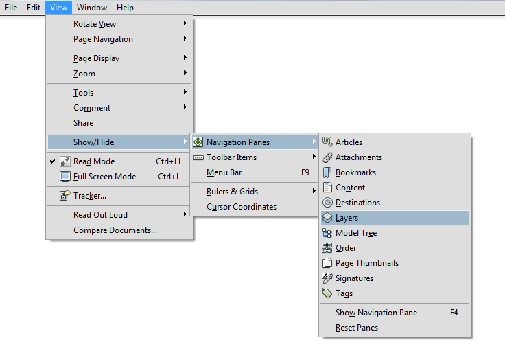
To
switch layers on and off,
click the Layers tool
![]() at the left of the screen. Alternatively, from the ‘View’ Menu in
Adobe Acrobat Reader select Show/Hide
>Navigation
Panes>Layers.
at the left of the screen. Alternatively, from the ‘View’ Menu in
Adobe Acrobat Reader select Show/Hide
>Navigation
Panes>Layers.

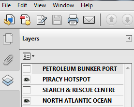
Selecting the relevant boxes in the ‘Layers’ pane will allow the independent or combined display in any combination of Piracy Hotspots, Petroleum Bunker Ports and Search and Rescue Centres, e.g. the figure below would show piracy hotspots on the North Atlantic Ocean map.

Lloyd's Maritime Atlas, 2013 © Informa UK 2013
Wyszukiwarka
Podobne podstrony:
[Mises org]Murphy,Robert Study Guide To Human Action A Treatise On Economics
Guide to MacOs X v10 4 1 Tiger x86 on VmWare v5 and Native
Herbs for Sports Performance, Energy and Recovery Guide to Optimal Sports Nutrition
Meezan Banks Guide to Islamic Banking
NLP for Beginners An Idiot Proof Guide to Neuro Linguistic Programming
50 Common Birds An Illistrated Guide to 50 of the Most Common North American Birds
Guide to the properties and uses of detergents in biology and biochemistry
Guide To Erotic Massage
A Guide to the Law and Courts in the Empire
10 Minutes Guide to Motivating Nieznany
Love; Routledge Philosophy Guidebook to Locke on Human Understanding
A Student's Guide to Literature R V Young(1)
A Practical Guide to Marketing Nieznany
Guide To Currency Trading Forex
Lockpick Leif Mccameron'S Guide To Lockpicking(1)
J T Velikovsky A Guide To Fe A Screenwriter's Workbook id 22
Answer Key Guide to Reading
Jouni Yrjola Easy Guide to the Classical Sicilian (feat Richter Rauzer and Sozin Attacks)
21 Appendix C Resource Guide to Fiber Optics