IS 2

Radar, Radio, Electronic Position-Fixing Systems IS
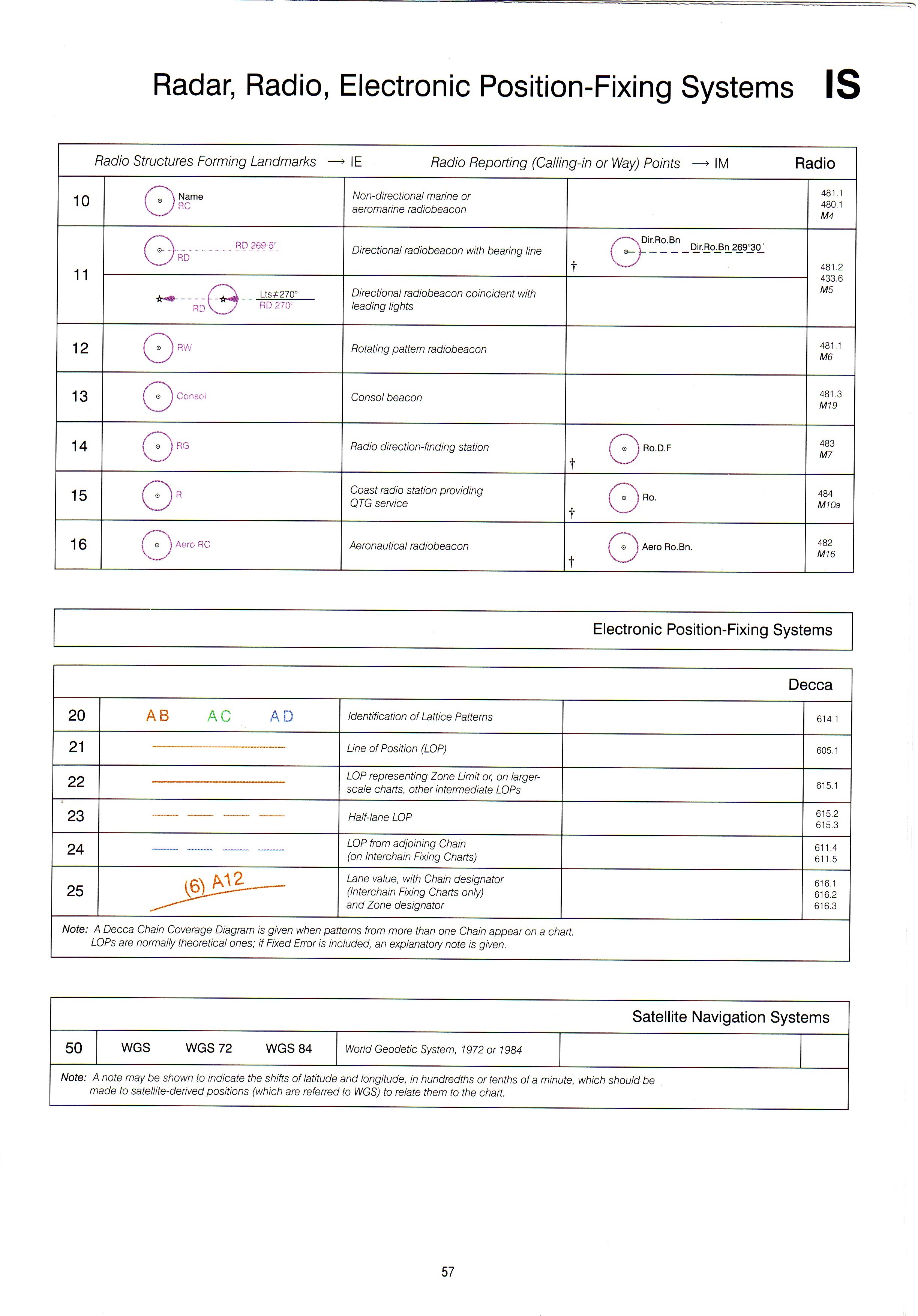
Electronic Position-Fixing Systems
|
Radio Structures Forming Landmarks —» IE Radio Reporting (Calling-in orWay) Points —>IM Radio | ||||
|
10 |
0re |
Non-directional marinę or aeromarine radiobeacon |
481.1 480.1 M4 | |
|
11 |
00 RD 269-5'' |
Directional radiobeacon with bearing linę |
/^""^\Dir.Ro.Bn „ f „ \ Dir.Ro.Bn 269 30 t W “ — |
481.2 433.6 M5 |
|
Lts«70° RDV_7 RD270' |
Directional radiobeacon coincident with leading lights | |||
|
12 |
0 RW |
Rotating pattern radiobeacon |
481.1 M6 | |
|
13 |
Consoi |
Consoibeacon |
481.3 M19 | |
|
14 |
Cz) rg |
Radio direction-finding station |
LL d O CC O *1— |
483 M7 |
|
15 |
cc O |
Coast radio station providing QTG service |
t O" |
484 M10a |
|
16 |
Aero RC |
Aeronautical radiobeacon |
Aero Ro.Bn. |
482 M16 |
|
Decca | ||||
|
20 |
AB AC AD |
Identification of Lattice Patterns |
614.1 | |
|
21 |
Linę of Position (LOP) |
605.1 | ||
|
22 |
LOP representing Zonę Limit or, on iarger-scale charts, other intermediate LOPs |
615.1 | ||
|
23 |
- —--— - |
Half-lane LOP |
615.2 615.3 | |
|
24 |
---— |
LOP from adjoining Chain (on Interchain Fixing Charts) |
611.4 611.5 | |
|
25 |
Lane value, with Chain designator (Interchain Fixing Charts only) and Zonę designator |
616.1 616.2 616.3 | ||
|
Notę: A Decca Chain Coverage Diagram is given when patterns from morę than one Chain appear on a chart. LOPs are normally theoretical ones; if Fixed Error is included, an explanatory notę is given. | ||||
|
Satellite Navigation Systems | ||||
|
50 |
WGS WGS 72 WGS 84 |
World Geodetic System. 1972 or 1984 | ||
|
Notę: A notę may be shown to indicate the shifts oflatitude and longitude, in hundredths or tenths of a minutę, which shoutd be madę to satellite-derived positions (which are referred to WGS) to relate them to the chart. | ||||
57
Wyszukiwarka
Podobne podstrony:
IS 1 IS Radar, Radio, Electronic Position-Fixing Systems Radar Radar Structures Forming Landmarks —»
Summary The dissertation is devoted to radio-fibre systems in which optical fibres are used to dis-t
43484 mbs 050 MY BREATHING SYSTEM diaphragm which is brought into a nearly vertical position when th
73679 system 70 70 shoulders, or to roli the body up. The head s natural position is inam tained whi
mbs 045 MY BRKATHINTt SYSTEM our breathing ? ” The author (Dr. Hulbert) submits that this is accompl
Weighted positional number systems In weighted-positional number systems each number is represented
p48 (7) ELECTRICAL SYSTEM this field is energized and generator output ILLUS. 35 TESTING REGULATING
Page06 6 L-JetronicL-Jetronic The L-Jetronic is an electronically con-trolled fuel-iniection system
38954 Kenwood378 8 RDS (Radio Data System) RDS is a digital Information system that lots you roceive
26946 Suzuki RM250? FUEL SYSTEM 9-5 Jet Needle Needle Clip Position The jet needle is linked to the
CHU0903WT02 NOTĘ: SECURITY LIGHT FLASHING SEOUENCE WHEN IGNITION SWITCH IS TURNED TO LOCK POSITION&n
więcej podobnych podstron