41 (319)

civilisations of ancient Mcsopotamia or Mesoamerica, for instance, similar mcthods aro applicable whcn outlining the unspecificd complexity of thc town-ccntres and their rank according to such measures.
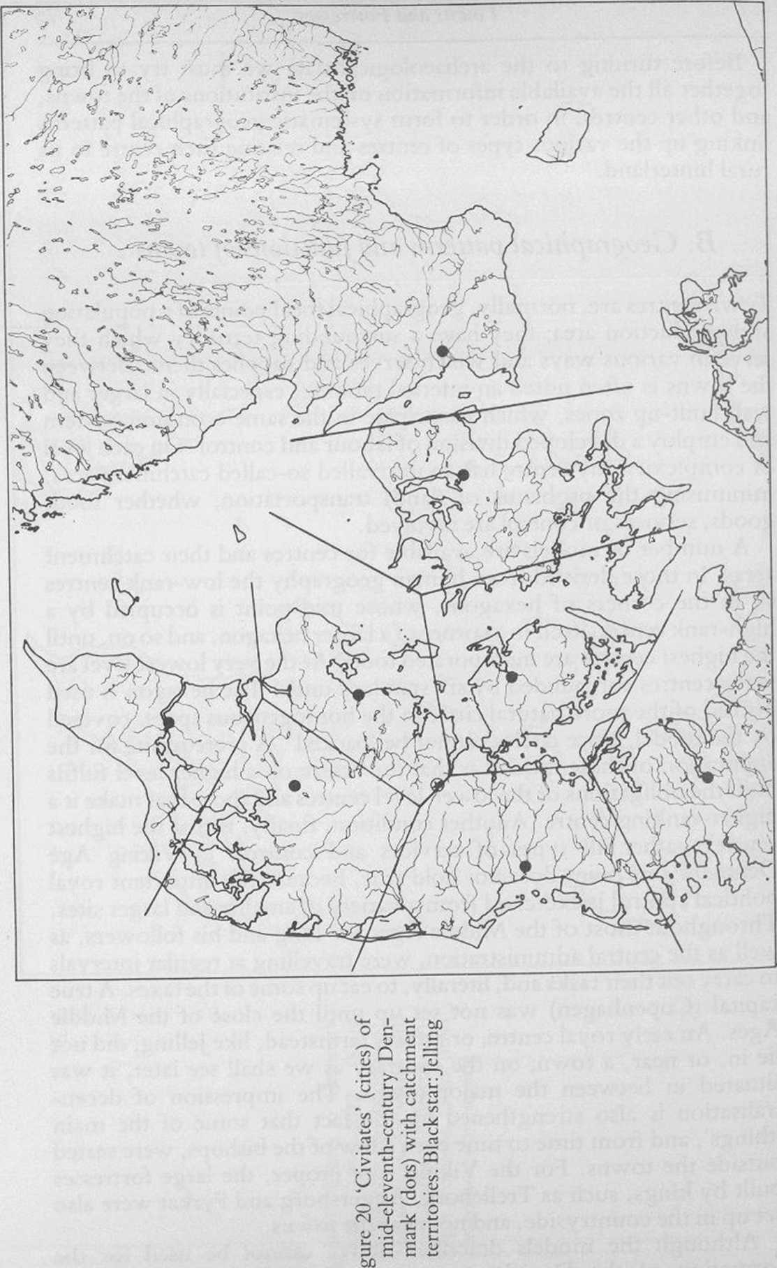
In the eighth century only two townships (kvicus74portus’) are known, Hedcby and Ribc, both in Southern Jylland. Along with the possible west Skanc market-site at Lóddekópingc,26 if in fact it does not start a little later, they are the only non-agricultural settlements known, and no certain pattem is established; moreover no written sources mention the localities. In the ninth century Hedcby and Ribe, but no other towns, are referred to in the written sources, and not until the tenth century are the data applicable for geographical analyses of thc kind we have outlined above. Among the towns we are hardly wrong in attributing Hedeby first rank and Ribe and Odense, on Fyn, second (Oldenburg, in the Slavonian Holstein to the east of Hedeby, may belong to the same group).27 Arhus should also be rnentioned here, but it lies so far away from Hedeby, with the Ribe-Odcnse-Oldenburg belt in between, that it constitutes a potential major centre. These towns are all tenth-century seats of bishops, and Hedeby in addition was probably thc seat of petty kings of the so-called ‘Swedish’ dynasty and an international port of transit. Arhus, and the smaller Odense, were possibly royal planned towns, perhaps with a special reference to the early Jelling-dynasty, to judge from their location. The same applies to Ribe, which in sonie instances may substitute for Hedcby, cspccially if aided by Arhus for the transit-traffic. Such a route passes through Jelling, and was eased, in the late tenth century, by thc construction of thc almost one-kilometre-long two-lane bridge across Vejle river-valley at Ravninge.28 At the same time the importance of Arhus is underlined by the cluster of‘After Jelling^type runestones from the city and its vicinity, indicating a new royal settlement (cf. above). To the north in Jylland the route from Hedeby, over Ravninge, leads to Viborg, which, although not yet a town, may initially havc had a central function as a pagan cult-site and a meeting (thing) and market place.
If we outline the catchment territories of the major sites, a striking junction is seen a couple ofkilometres from Jelling in mid-Jylland (Fig. 20). (The technique is simply to dra w straight borderlines in a right angle across the linę ofsighting between the towns, etc., and through the mid-point of the linę). Jelling is optimally situated for command and control of the highest possible number of other centres, a position which was critically located with the tenth-century political dcve-lopment in mind. Hedeby and the fortifications and fortresses at Danevirke, Trclleborg, Fyrkat and Aggersborg lic in a ring further away (cf. Fig. 1). In addition, they are situated close to sonie of the most important transportation routes in western Denmark, and we are reminded that State control is very much a question of ovcrcoming
Wyszukiwarka
Podobne podstrony:
gear?ces Drill to match diameter of your bolt, or optionally for a bali bearing.
00102 B2805d720a3f852501694e34fead415 101 The OCAP seldom-used terminators can be moved to the end
img073 (20) sources for suppliesContact the companies listed below if you dorit know of a local reta
• ensuring that the person in charge of a unit, plant or installation is aware of
SDC10587 Tytuł oryginału The British Museum Book of ANCIENT EGYPT © 1992 and 2007 The Trustees of th
IMGR31 (2) IGILDINC AND TECHNIQUES OF DECORATIONpcpatcd with glair, or somc othcr adheiwc, prior to
F00574 009 f002 Routes of cxposurc to toxinsDirect eye contact Eye Eye irrigationMethods of preventi
m POLITECHNIKA GDAŃSKAIntroduction Internet of Things (loT) The network of physical objects or
IH 2 Tides, Currents IHTide Tables30 Tabular statement of semi-diurnal or diurnal tides Tidal Leyels
help2 MIRACLE OUADS FORM MATCHES OF 4 IN-A-OUAD OR MORĘ IDENTICAl GIFTS HORIZONTALLY OR VERTICA
Improve the protection of your house or car with this Building this Iow cost unit and adding it to a
« ANNEX 6 p.l of 3mb aaimic or monNAHOHAL Background 1. The agrlcultural seccor,
więcej podobnych podstron