2949775843
65
Land value map as a source of information about local real estate market
tion was used to determine the percentage share for each feature affecting it. The results are presented in Table 1.
Table 1. Degree of explaining the difference łn transaction prices with the features under study
|
Position in relation to the city centre |
Dominant type of buildings |
Technical condition of buildings |
Environmental conditions |
Public transport |
Technical condition of road surfaces |
'o 4 o |
Social infrastructure |
Fashion |
Safety |
Residents' status |
Population density | |
|
Degree of explaining the difference in land prices (in %) |
14.39 |
4.05 |
2.78 |
13.53 |
20.09 |
23.30 |
8.26 |
8.26 |
0.08 |
3.17 |
1.46 |
0.65 |
Source: own materiał
In the case of land real estate, access by road, public transport accessibility and the lo-cation affected the prices to the greatest extent. Whether the location was fashionable or not had the smallest effect on the price.
Because of a strong correlation between particular variables which characterised partic-ular districts, the adopted features were grouped according to their similar character. Clus-ter analysis was used to this end (Fig. 1).
Tree diagram Single bond Euclidean distance
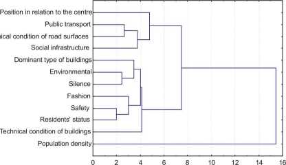
Fig. 1. Results of agglomeration of particular features of districts Source: own materiał
Wyszukiwarka
Podobne podstrony:
73 Land value map as a source of information about local real estate marketReferences [1]
Land value map as a source of information about local real estate market 67 The effect of these fact
Land value map as a source of information about local real estate market 69 Another group of value m
Land value map as a source of information about local real estate market 71 Several factors had to b
GEODEZJA • TOM 11 • Zeszyt 1/1 • 2005 Sabina Źróbek1, Radosław Cellmer1, Jan Kuryj1 LAND VALUE MAP A
70 S. Źróbek, R. Cellmer, J. Kuryj The following were the basis for the land value map: —
UHAM012 Preface This book should, I hope, be a useful source of Information for two groups of people
DEFINING THE LAND VALUE ZONES WITH USE OF GEOSTATISTICAL METHODSRadosław Cellmer, Jan KuryjDepartmen
JPRS-EER-91-053 2S April 1991ECONOMIC 35 Maritsa-Iztok as a source of energy, construction of the nu
Classroom language 1 IN THE CLASSROOM The classroom is often overlooked as a source of ‘authentic’ c
C. To determine the importance of the detailed geomorphological map for the development of geomorpho
C. To determine the importance of the detailed geomorphological map for the development of geomorpho
image012 Further information about Arcona concem its fali, which is widely reflected in the sources.
226 (23) Microscopic examination of cerumen, collected with a curette or swab, can be used to look f
00128 ?541c295e5c443a126cf2c578c908b3 129 Optimization and Sensitivity Analysis is to determine the
Michał PTAK used to improve the energy efficiency of buildings. Additionally, there were projects wh
hammer of thor This mystic artifact can act once per tum. Its action can be used to increase the Pow
więcej podobnych podstron