6585844926
Penetration testing in Sweden esopt
R. Dahlberg State-of-the-art report

The report consists of five main parts treating (1) geology of Sweden, (2) developments and stan-dardization efforts within the sounding field, economical aspects on penetration testing and interpretation of test results, (3) description of Swedish sounding methods, (4) a geotechnical storage and retrieval system under deve1opment and (5) cooperation in Scandinavia and Europę within the sounding field.
GEOLOGY OF SWEDEN Rock condltlons
The rock in Sweden is primarily of Precambrian origin and consists mainly of gneiss and grani te. The Swedish bedrock has, however, previously been largely covered by later sedimentary rocks, primarily of Cambrosilurian age but also from the Triassic, Jurassic, Cretaceous and Tertiary pe-riods. These later deposits have to a large extent been eroded away but they have been of great importance for the composition and forma-tion of the glacial deposits, e.g. the boulder clays and the fine-grained tills.
Soli conditions
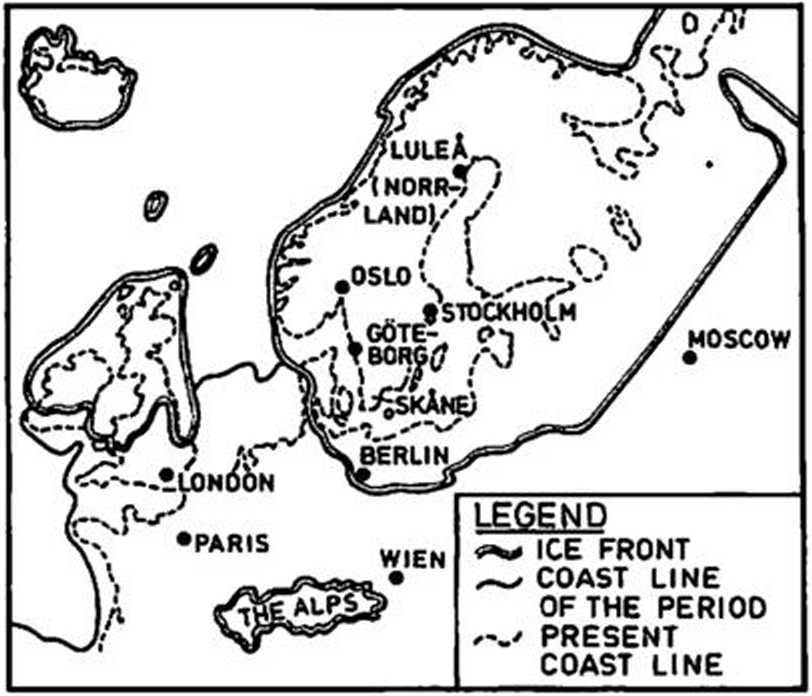
The soil 1n Sweden which primarily -*s of Ouater-nary age was mainly deposited during and after the last glaciation. During the last glacial period, when the ice had its maximum extension, the Southern limit stretched across Denmark and northern Germany (Fig. 1).

Fig. 1
Last ice age, about 27.000 years ago. Source: Atlas over Sverige.
The surface features of the land, the drainage systems and the geographical distribution of the soils have to a large extent been modelled by the last glaciation, either directly by the ice or indirectly through sedimentation in the sea or in glacial lakes or river$ in connection with the melting of the ice. Also the land upheaval after the melting of the ice has been of importance for the present soil conditions in Sweden. The regression of the ice took place gradually over a period of about 5000 years, starting about 14000 years ago in the Southern part of Sweden. About 8800 years ago only isolated ice fields (dead ice) remained.
Due to the unloading caused by the melting of the glaciers a considerable upheaval of the country occurred. The ratę of the upheaval was initially large, but the present ratę is about 9 mm/year at LuleS in the northern part of Sweden and 4 rrm/year in Stockholm.
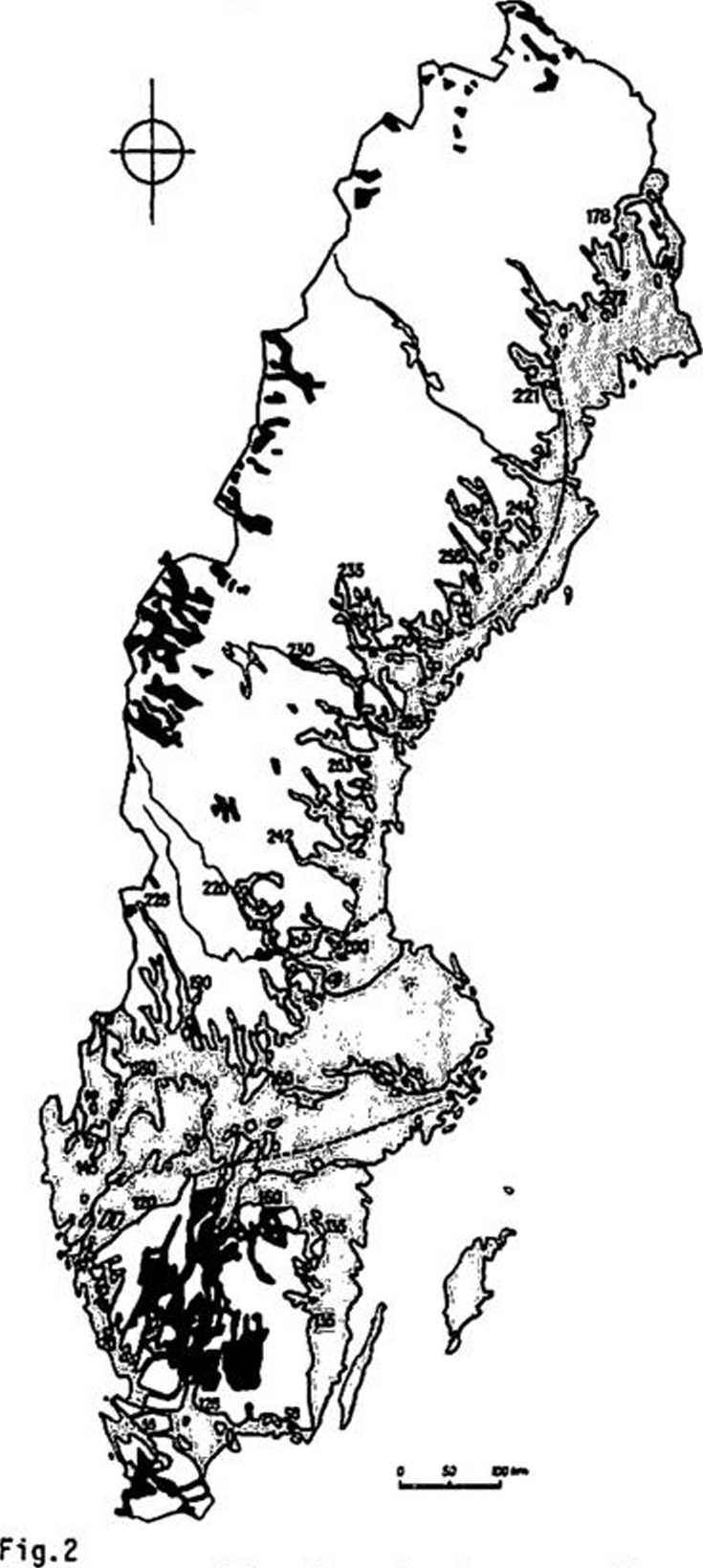
A large part of Sweden was covered by water during the last stages of deglaciation. In Fig.2 is shown the highest level of the coast linę.
Highest coast linę (boundary between white and grey coloured areas) and most important ice lakes (dark colour). Source: Atlas over Sverige. Copyright by J Lundqvist and Almqvist & Wiksell.
Wyszukiwarka
Podobne podstrony:
Penetration testing in Portugal esoptJ. Folque State-of-the-art
Penetration testing in Australia esoptJ.C. Holden State-of-the-a
Penetration testing in Denmark esoptA. Hansen State-of-the-art
Penetration testing in Netherlands esoptW.J. Heijnen State-of-th
Penetration testing in Norway esoptK. Senneset State-of-the-art
ESOPT State-of-the-art reportPenetration testing in IsraelA. Komornik The most common type of penetr
Penetration testing in South Africa esoptD.L. Webb State-of-the-
ESOPT State-of-the-art reportPenetration testing in SpainV. Escario 1. INFLUENCE O
ESOPT State-of-the-art reportPenetration testing in TurkeyH. T. Durgunoglu & E. Togrol The stand
ESOPT State-of-the-art reportPenetration testing in USSRJ.G. Trofimenkov I. THE BACKGEOOND ON THE OS
ESOPT State-of-the-art reportPenetration testing in CanadaW.J. Eden Because of the size of the count
ESOPT State-of-the-art reportPenetration testing in IndiaM.D. Desai, G.R.S. Jain, Swami Saran &
ESOPT State-of-the-art reportPenetration testing in JapanT. Muromachi, I. Oguro & T. Miyashita T
ESOPT State-of-the-art reportPenetration testing in USAJ.H. Schmertmann Because of Its versat1l1ty t
ESOPT State-of-the-art reportPenetration testing in CzechoslovakiaK. Drozd & M. Svasta The devel
RCA HOME VIDEO CAMERASNO ONE GIlfESYOU MORĘ PROFESSIONAL RESULTSTHE STATE-OF-THE-ART IN FEATURES. Vi
ROZMOWA Z DREM H. SAWONIAKIEM 275 wydawnictwa zwą się ,,State of the art”, są one ważne ze względu n
Penetration testing in Switzerland esoptP. Crettaz & H. Zeindler
więcej podobnych podstron