
483
CHAPTER 35
WEATHER ELEMENTS
GENERAL DESCRIPTION OF THE ATMOSPHERE
3500. Introduction
Weather is the state of the earth’s atmosphere with re-
spect to temperature, humidity, precipitation, visibility,
cloudiness, and other factors. Climate refers to the average
long-term meteorological conditions of a place or region.
All weather may be traced to the effect of the sun on the
earth. Most changes in weather involve large-scale horizon-
tal motion of air. Air in motion is called wind. This motion
is produced by differences of atmospheric pressure, which
are attributable both to differences of temperature and the
nature of the motion itself.
Weather is of vital importance to the mariner. The
wind and state of the sea affect dead reckoning. Reduced
visibility limits piloting. The state of the atmosphere affects
electronic navigation and radio communication. If the skies
are overcast, celestial observations are not available; and
under certain conditions refraction and dip are disturbed.
When wind was the primary motive power, knowledge of
the areas of favorable winds was of great importance. Mod-
ern vessels are still affected considerably by wind and sea.
3501. The Atmosphere
The atmosphere is a relatively thin shell of air, water
vapor, and suspended particulates surrounding the earth.
Air is a mixture gases and, like any gas, is elastic and highly
compressible. Although extremely light, it has a definite
weight which can be measured. A cubic foot of air at stan-
dard sea-level temperature and pressure weighs 1.22
ounces, or about
1
/
817
th the weight of an equal volume of
water. Because of this weight, the atmosphere exerts a pres-
sure upon the surface of the earth of about 15 pounds per
square inch.
As altitude increases, air pressure decreases due to the
decreased weight of air above. With less pressure, the den-
sity decreases. More than three-fourths of the air is
concentrated within a layer averaging about 7 statute miles
thick, called the troposphere. This is the region of most
“weather,” as the term is commonly understood.
The top of the troposphere is marked by a thin transi-
tion zone called the tropopause, immediately above which
is the stratosphere. Beyond this lie several other layers
having distinctive characteristics. The average height of the
tropopause ranges from about 5 miles or less at high lati-
tudes to about 10 miles at low latitudes.
The standard atmosphere is a conventional vertical
structure of the atmosphere characterized by a standard sea-
level pressure of 1013.25 millibars of mercury (29.92 inch-
es) and a sea-level air temperature of 15
°
C (59
°
F). The
temperature decreases with height (i.e., standard lapse
rate) being a uniform 2
°
C (3.6
°
F) per thousand feet to 11
kilometers (36,089 feet) and thereafter remains constant at
–56.5
°
C (69.7
°
F).
Research has indicated that the jet stream is important
in relation to the sequence of weather. The jet stream refers
to relatively strong (
≤
60 knots) quasi-horizontal winds,
usually concentrated within a restricted layer of the atmo-
sphere. There are two commonly known jet streams. The
sub-tropical jet stream (STJ) occurs in the region of 30
°
N
during the northern hemisphere winter, decreasing in sum-
mer. The core of highest winds in the STJ is found at about
12km altitude (40,000 feet) an in the region of 70
°
W, 40
°
E,
and 150
°
E, although considerable variability is common.
The polar frontal jet stream (PFJ) is found in middle to
upper-middle latitudes and is discontinuous and variable.
Maximum jet stream winds have been measured by weather
balloons at 291 knots.
3502. General Circulation Of The Atmosphere
The heat required to warm the air is supplied originally
by the sun. As radiant energy from the sun arrives at the
earth, about 29 percent is reflected back into space by the
earth and its atmosphere, 19 percent is absorbed by the at-
mosphere, and the remaining 52 percent is absorbed by the
surface of the earth. Much of the earth’s absorbed heat is ra-
diated back into space. Earth’s radiation is in comparatively
long waves relative to the short-wave radiation from the sun
because it emanates from a cooler body. Long-wave radia-
tion, readily absorbed by the water vapor in the air, is
primarily responsible for the warmth of the atmosphere
near the earth’s surface. Thus, the atmosphere acts much
like the glass on the roof of a greenhouse. It allows part of
the incoming solar radiation to reach the surface of the earth
but is heated by the terrestrial radiation passing outward.
Over the entire earth and for long periods of time, the total
outgoing energy must be equivalent to the incoming energy
(minus any converted to another form and retained), or the
temperature of the earth and its atmosphere would steadily
increase or decrease. In local areas, or over relatively short
periods of time, such a balance is not required, and in fact
484
WEATHER ELEMENTS
does not exist, resulting in changes such as those occurring
from one year to another, in different seasons and in differ-
ent parts of the day.
The more nearly perpendicular the rays of the sun
strike the surface of the earth, the more heat energy per unit
area is received at that place. Physical measurements show
that in the tropics, more heat per unit area is received than
is radiated away, and that in polar regions, the opposite is
true. Unless there were some process to transfer heat from
the tropics to polar regions, the tropics would be much
warmer than they are, and the polar regions would be much
colder. Atmospheric motions bring about the required
transfer of heat. The oceans also participate in the process,
but to a lesser degree.
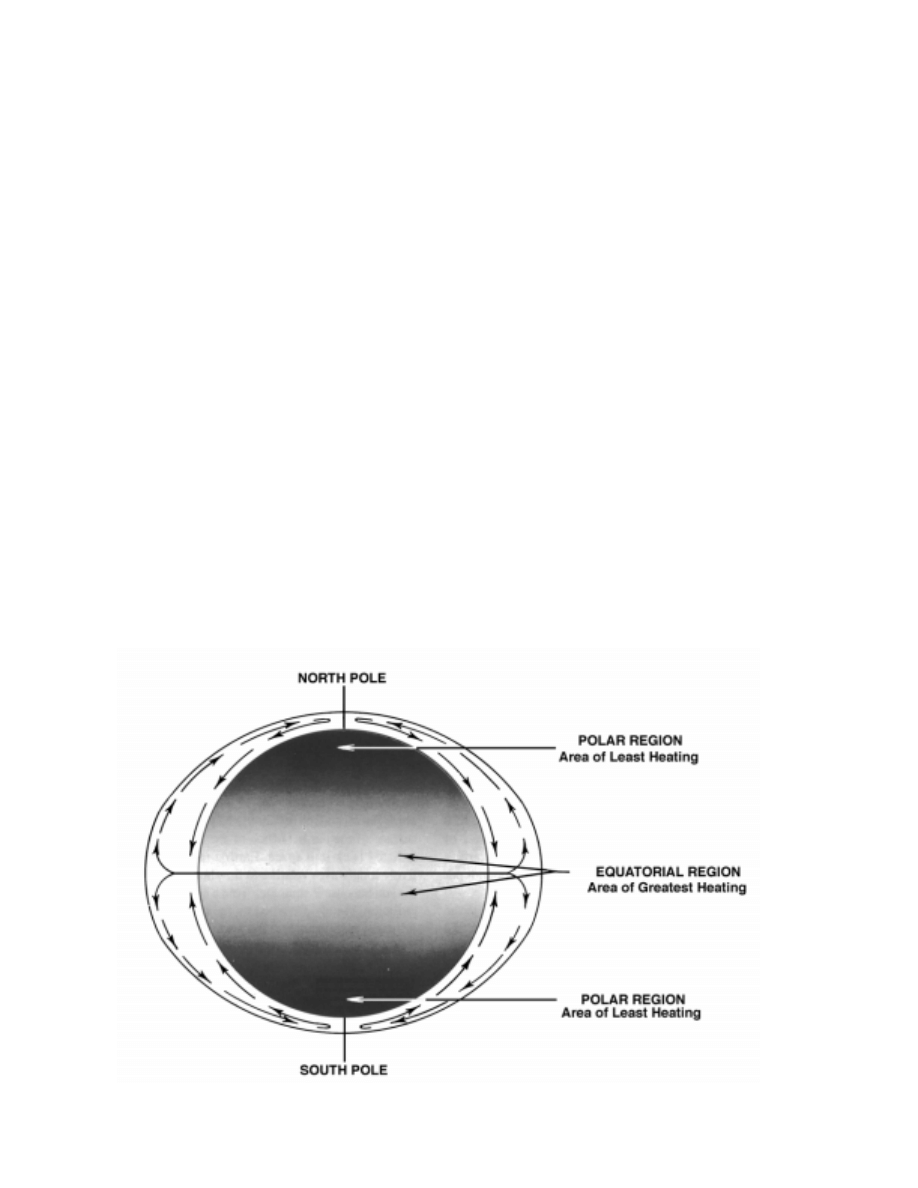
If the earth had a uniform surface and did not rotate on
its axis, with the sun following its normal path across the
sky (solar heating increasing with decreasing latitude), a
simple circulation would result, as shown in Figure 3502a.
However, the surface of the earth is far from uniform, being
covered with an irregular distribution of land and water.
Additionally, the earth rotates about its axis so that the por-
tion heated by the sun continually changes. In addition, the
axis of rotation is tilted so that as the earth moves along its
orbit about the sun, seasonal changes occur in the exposure
of specific areas to the sun’s rays, resulting in variations in
the heat balance of these areas. These factors, coupled with
others, result in constantly changing large-scale movements
of air. For example, the rotation of the earth exerts an appar-
ent force, known as Coriolis force, which diverts the air
from a direct path between high and low pressure areas. The
diversion of the air is toward the right in the Northern
Hemisphere and toward the left in the Southern Hemi-
sphere. At some distance above the surface of the earth, the
wind tends to blow along lines connecting points of equal
pressure called isobars. The wind is called a geostrophic
wind if the isobars are straight (great circles) and a gradi-
ent wind if they are curved. Near the surface of the earth,
friction tends to divert the wind from the isobars toward the
center of low pressure. At sea, where friction is less than on
land, the wind follows the isobars more closely.
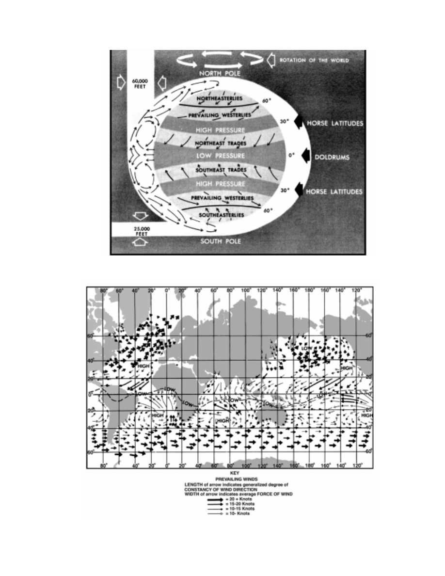
A simplified diagram of the general circulation pattern
is shown in Figure 3502b. Figure 3502c and Figure 3502d
give a generalized picture of the world’s pressure distribu-
tion and wind systems as actually observed.
A change in pressure with horizontal distance is called
a pressure gradient. It is maximum along a normal (per-
pendicular) to the isobars. A force results which is called
pressure gradient force and is always directed from high
to low pressure. Speed of the wind is approximately propor-
tional to this pressure gradient.
Figure 3502a. Ideal atmospheric circulation for a uniform and nonrotating earth.
WEATHER ELEMENTS
485
Figure 3502b. Simplified diagram of the general circulation of the atmosphere.
Figure 3502c. Generalized pattern of actual surface winds in January and February.
486
WEATHER ELEMENTS
MAJOR WIND PATTERNS
3503. The Doldrums
A belt of low pressure at the earth’s surface near the
equator known as the doldrums occupies a position approx-
imately midway between high pressure belts at about latitude
30
°
to 35
°
on each side. Except for significant intradiurnal
changes, the atmospheric pressure along the equatorial low is
almost uniform. With minimal pressure gradient, wind
speeds are light and directions are variable. Hot, sultry days
are common. The sky is often overcast, and showers and
thundershowers are relatively frequent; in these atmospheri-
cally unstable areas, brief periods of strong wind occur.
The doldrums occupy a thin belt near the equator, the
eastern part in both the Atlantic and Pacific being wider
than the western part. However, both the position and ex-
tent of the belt vary with longitude and season. During all
seasons in the Northern Hemisphere, the belt is centered in
the eastern Atlantic and Pacific; however, there are wide
excursions of the doldrum regions at longitudes with con-
siderable landmass. On the average, the position is at 5
°
N,
frequently called the meteorological equator.
3504. The Trade Winds
The trade winds at the surface blow from the belts of
high pressure toward the equatorial belts of low pressure.
Because of the rotation of the earth, the moving air is de-
flected toward the west. Therefore, the trade winds in the
Northern Hemisphere are from the northeast and are called
the northeast trades, while those in the Southern Hemi-
sphere are from the southeast and are called the southeast
trades. The trade-wind directions are best defined over
eastern ocean areas.
The trade winds are generally considered among the
most constant of winds, blowing for days or even weeks
with little change of direction or speed. However, at times
they weaken or shift direction, and there are regions where
the general pattern is disrupted. A notable example is found
in the island groups of the South Pacific, where the trades
are practically nonexistent during January and February.
Their best development is attained in the South Atlantic and
in the South Indian Ocean. In general, they are stronger dur-
ing the winter than during the summer season.
In July and August, when the belt of equatorial low
pressure moves to a position some distance north of the
equator, the southeast trades blow across the equator, into
the Northern Hemisphere, where the earth’s rotation diverts
them toward the right, causing them to be southerly and
southwesterly winds. The “southwest monsoons” of the Af-
rican and Central American coasts originate partly in these
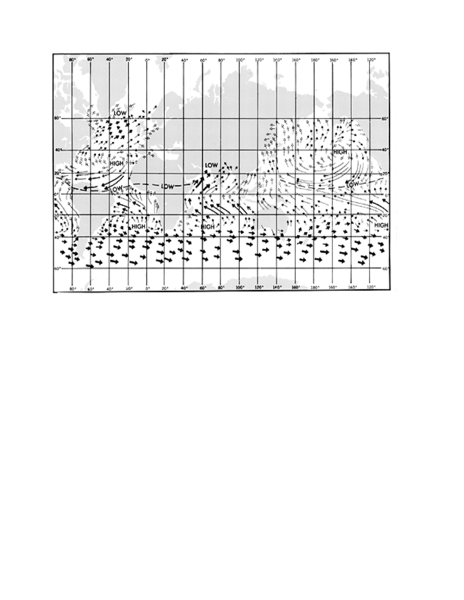
Figure 3502d. Generalized pattern of actual surface winds in July and August. (See key with Figure 3502c.)

WEATHER ELEMENTS
487
diverted southeast trades.
Cyclones from the middle latitudes rarely enter the re-
gions of the trade winds, although tropical cyclones
originate within these areas.
3505. The Horse Latitudes
Along the poleward side of each trade-wind belt, and cor-
responding approximately with the belt of high pressure in
each hemisphere, is another region with weak pressure gradi-
ents and correspondingly light, variable winds. These are
called the horse latitudes, apparently so named because be-
calmed sailing ships threw horses overboard in this region
when water supplies ran short. The weather is generally good
although low clouds are common. Compared to the doldrums,
periods of stagnation in the horse latitudes are less persistent.
The difference is due primarily to the rising currents of warm
air in the equatorial low, which carry large amounts of mois-
ture. This moisture condenses as the air cools at higher levels,
while in the horse latitudes the air is apparently descending
and becoming less humid as it is warmed at lower heights.
3506. The Prevailing Westerlies
On the poleward side of the high pressure belt in each
hemisphere, the atmospheric pressure again diminishes.
The currents of air set in motion along these gradients to-
ward the poles are diverted by the earth’s rotation toward
the east, becoming southwesterly winds in the Northern
Hemisphere and northwesterly in the Southern Hemi-
sphere. These two wind systems are known as the
prevailing westerlies of the temperate zones.
In the Northern Hemisphere this relatively simple pat-
tern is distorted considerably by secondary wind
circulations, due primarily to the presence of large land-
masses. In the North Atlantic, between latitudes 40
°
and
50
°
, winds blow from some direction between south and
northwest during 74 percent of the time, being somewhat
more persistent in winter than in summer. They are stronger
in winter, too, averaging about 25 knots (Beaufort 6) as
compared with 14 knots (Beaufort 4) in the summer.
In the Southern Hemisphere the westerlies blow
throughout the year with a steadiness approaching that of
the trade winds. The speed, though variable, is generally be-
tween 17 and 27 knots (Beaufort 5 and 6). Latitudes 40
°
S to
50
°
S (or 55
°
S) where these boisterous winds occur, are
called the roaring forties. These winds are strongest at
about latitude 50
°
S.
The greater speed and persistence of the westerlies in
the Southern Hemisphere are due to the difference in the at-
mospheric pressure pattern, and its variations, from the
Northern Hemisphere. In the comparatively landless South-
ern Hemisphere, the average yearly atmospheric pressure
diminishes much more rapidly on the poleward side of the
high pressure belt, and has fewer irregularities due to conti-
nental interference, than in the Northern Hemisphere.
3507. Polar Winds
Partly because of the low temperatures near the geo-
graphical poles of the earth, the surface pressure tends to
remain higher than in surrounding regions, since cold air is
more dense than warm air. Consequently, the winds blow
outward from the poles, and are deflected westward by the
rotation of the earth, to become northeasterlies in the Arc-
tic, and southeasterlies in the Antarctic. Where the polar
easterlies meet the prevailing westerlies, near 50
°
N and
50
°
S on the average, a discontinuity in temperature and
wind exists. This discontinuity is called the polar front.
Here the warmer low-latitude air ascends over the colder
polar air creating a zone of cloudiness and precipitation.
In the Arctic, the general circulation is greatly modi-
fied by surrounding landmasses. Winds over the Arctic
Ocean are somewhat variable, and strong surface winds are
rarely encountered.
In the Antarctic, on the other hand, a high central land-
mass is surrounded by water, a condition which augments,
rather than diminishes, the general circulation. The high
pressure, although weaker than in the horse latitudes, is
stronger than in the Arctic, and of great persistence espe-
cially in eastern Antarctica. The cold air from the plateau
areas moves outward and downward toward the sea and is
deflected toward the west by the earth’s rotation. The winds
remain strong throughout the year, frequently attaining hur-
ricane force near the base of the mountains. These are some
of the strongest surface winds encountered anywhere in the
world, with the possible exception of those in well-devel-
oped tropical cyclones.
3508. Modifications Of The General Circulation
The general circulation of the atmosphere is greatly
modified by various conditions.
The high pressure in the horse latitudes is not uniform-
ly distributed around the belts, but tends to be accentuated
at several points, as shown in Figure 3502c and Figure
3502d. These semi-permanent highs remain at about the
same places with great persistence.
Semi-permanent lows also occur in various places, the
most prominent ones being west of Iceland, and over the
Aleutians (winter only) in the Northern Hemisphere, and in
the Ross Sea and Weddell Sea in the Antarctic areas. The re-
gions occupied by these semi-permanent lows are sometimes
called the graveyards of the lows, since many lows move di-
rectly into these areas and lose their identity as they merge
with and reinforce the semi-permanent lows. The low pres-
sure in these areas is maintained largely by the migratory lows
which stall there, with topography also important, especially
in Antarctica.
Another modifying influence is land, which undergoes
greater temperature changes than does the sea. During the
summer, a continent is warmer than its adjacent oceans.
Therefore, low pressures tend to prevail over the land. If a cli-
488
WEATHER ELEMENTS
matological belt of high pressure encounters a continent, its
pattern is distorted or interrupted, whereas a belt of low pres-
sure is intensified over the same area. In winter, the opposite
effect takes place, belts of high pressure being intensified over
land and those of low pressure being weakened.
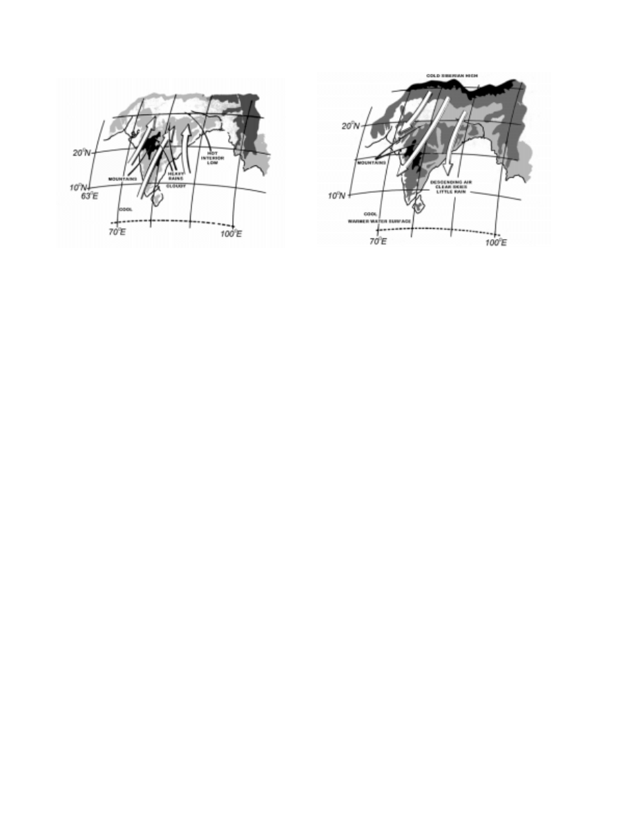
The most striking example of a wind system produced by
the alternate heating and cooling of a landmass is the mon-
soon (seasonal wind) of the China Sea and Indian Ocean. A
portion of this effect is shown in Figure 3508a and Figure
3508b. In the summer, low pressure prevails over the warm
continent of Asia, and relatively higher pressure prevails over
the adjacent sea. Between these two systems the wind blows
in a nearly steady direction. The lower portion of the pattern
is in the Southern Hemisphere, extending to about 10
°
south
latitude. Here the rotation of the earth causes a deflection to
the left, resulting in southeasterly winds. As they cross the
equator, the deflection is in the opposite direction, causing
them to curve toward the right, becoming southwesterly
winds. In the winter, the positions of high and low pressure ar-
eas are interchanged, and the direction of flow is reversed.
In the China Sea, the summer monsoon blows from the
southwest, usually from May to September. The strong
winds are accompanied by heavy squalls and thunder-
storms, the rainfall being much heavier than during the
winter monsoon. As the season advances, squalls and rain
become less frequent. In some places the wind becomes a
light breeze which is unsteady in direction, or stops alto-
gether, while in other places it continues almost
undiminished, with changes in direction or calms being in-
frequent. The winter monsoon blows from the northeast,
usually from October to April. It blows with a steadiness
similar to that of the trade winds, often attaining the speed
of a moderate gale (28–33 knots). Skies are generally clear
during this season, and there is relatively little rain.
The general circulation is further modified by winds of
cyclonic origin and various local winds. Some common lo-
cal winds are listed by local name below.
Figure 3508a. The summer monsoon.
Figure 3508b. The winter monsoon.
Abroholos
A squall frequent from May through
August between Cabo de Sao Tome
and Cabo Frio on the coast of Brazil.
Bali wind
A strong east wind at the eastern end
of Java.
Barat
A heavy northwest squall in Manado Bay
on the north coast of the island of Celebes,
prevalent from December to February.
Barber
A strong wind carrying damp snow or
sleet and spray that freezes upon contact
with objects, especially the beard and hair.
Bayamo
A violent wind blowing from the land
on the south coast of Cuba, especially
near the Bight of Bayamo.
Bentu de Soli
An east wind on the coast of Sardinia.
Bora
A cold, northerly wind blowing from
the Hungarian basin into the Adriatic
Sea. See also FALL WIND.
Borasco
A thunderstorm or violent squall,
especially in the Mediterranean.
Brisa, Briza
1. A northeast wind which blows on
the coast of South America or an east
wind which blows on Puerto Rico
during the trade wind season. 2. The
northeast monsoon in the Philippines.
Brisote
The northeast trade wind when it is
blowing stronger than usual on Cuba.
Brubu
A name for a squall in the East Indies.
Bull’s Eye Squall
A squall forming in fair weather,

WEATHER ELEMENTS
489
Bull’s Eye Squall
(continued)
characteristic of the ocean off the coast
of South Africa. It is named for the
peculiar appearance of the small
isolated cloud marking the top of the
invisible vortex of the storm.
Cape Doctor
The strong southeast wind which
blows on the South African coast. Also
called the DOCTOR.
Caver, Kaver
A gentle breeze in the Hebrides.
Chubasco
A violent squall with thunder and
lightning, encountered during the rainy
season along the west coast of Central
America.
Churada
A severe rain squall in the Mariana Islands
during the northeast monsoon. They occur
from November to April or May,
especially from January through March.
Cierzo
See MISTRAL.
Contrastes
Winds a short distance apart blowing from
opposite quadrants, frequent in the spring
and fall in the western Mediterranean.
Cordonazo
The “Lash of St. Francis.” Name
applied locally to southerly hurricane
winds along the west coast of Mexico.
It is associated with tropical cyclones
in the southeastern North Pacific
Ocean. These storms may occur from
May to November, but ordinarily affect
the coastal areas most severely near or
after the Feast of St. Francis, October 4.
Coromell
A night land breeze prevailing from
November to May at La Paz, near the
southern extremity of the Gulf of
California.
Doctor
1. A cooling sea breeze in the Tropics.
2. See HARMATTAN. 3. The strong
SE wind which blows on the south
African coast. Usually called CAPE
DOCTOR.
Elephanta
A strong southerly or southeasterly
wind which blows on the Malabar
coast of India during the months of
September and October and marks the
end of the southwest monsoon.
Etesian
A refreshing northerly summer wind
of the Mediterranean, especially over
the Aegean Sea.
Gregale
A strong northeast wind of the central
Mediterranean.
Harmattan
The dry, dusty trade wind blowing off
the Sahara Desert across the Gulf of
Guinea and the Cape Verde Islands.
Sometimes called the DOCTOR, because
of its supposed healthful properties.
Knik Wind
A strong southeast wind in the vicinity
of Palmer, Alaska, most frequent in the
winter.
Kona Storm
A storm over the Hawaiian Islands,
characterized by strong southerly or
southwesterly winds and heavy rains.
Leste
A hot, dry, easterly wind of the
Madeira and Canary Islands.
Levanter
A strong easterly wind of the Mediterrane-
an, especially in the Strait of Gibraltar,
attended by cloudy, foggy, and sometimes
rainy weather especially in winter.
Levantera
A persistent east wind of the Adriatic,
usually accompanied by cloudy weather.
Levanto
A hot southeasterly wind which blows
over the Canary Islands.
Leveche
A warm wind in Spain, either a foehn
or a hot southerly wind in advance of a
low pressure area moving from the
Sahara Desert. Called a SIROCCO in
other parts of the Mediterranean area.
Maestro
A northwesterly wind with fine
weather which blows, especially in
summer, in the Adriatic. It is most
frequent on the western shore. This
wind is also found on the coasts of
Corsica and Sardinia.
Matanuska Wind
A strong, gusty, northeast wind which
occasionally occurs during the winter
in the vicinity of Palmer, Alaska.
Mistral
A cold, dry wind blowing from the
north over the northwest coast of the
Mediterranean Sea, particularly over
the Gulf of Lions. Also called
CIERZO. See also FALL WIND.
Nashi, N’aschi
A northeast wind which occurs in
winter on the Iranian coast of the
Persian Gulf, especially near the
entrance to the gulf, and also on the
Makran coast. It is probably associated
with an outflow from the central Asiatic
anticyclone which extends over the high
land of Iran. It is similar in character but
less severe than the BORA.
Norte
A strong cold northeasterly wind which
blows in Mexico and on the shores of
the Gulf of Mexico. It results from an
outbreak of cold air from the north. It is
the Mexican extension of a norther.
Papagayo
A violet northeasterly fall wind on the
Pacific coast of Nicaragua and
Guatemala. It consists of the cold air
mass of a norte which has overridden
the mountains of Central America. See
also TEHUANTEPECER.
Santa Ana
A strong, hot, dry wind blowing out into
San Pedro Channel from the southern
California desert through Santa Ana Pass.
Shamal
A summer northwesterly wind blowing
over Iraq and the Persian Gulf, often
strong during the day, but decreasing
at night.

490
WEATHER ELEMENTS
AIR MASSES
3509. Types Of Air Masses
Because of large differences in physical characteristics
of the earth’s surface, particularly the oceanic and continen-
tal contrasts, the air overlying these surfaces acquires
differing values of temperature and moisture. The processes
of radiation and convection in the lower portions of the tro-
posphere act in differing characteristic manners for a
number of well-defined regions of the earth. The air overly-
ing these regions acquires characteristics common to the
particular area, but contrasting to those of other areas. Each
distinctive part of the atmosphere, within which common
characteristics prevail over a reasonably large area, is called
an air mass.
Air masses are named according to their source re-
gions. Four regions are generally recognized: (1) equatorial
(E), the doldrums area between the north and south trades;
(2) tropical (T), the trade wind and lower temperate regions;
(3) polar (P), the higher temperate latitudes; and (4) Arctic
or Antarctic (A), the north or south polar regions of ice and
snow. This classification is a general indication of relative
temperature, as well as latitude of origin.
Air masses are further classified as maritime (m) or
continental (c), depending upon whether they form over
water or land. This classification is an indication of the rel-
ative moisture content of the air mass. Tropical air might be
designated maritime tropical (mT) or continental tropical
(cT). Similarly, polar air may be either maritime polar (mP)
or continental polar (cP). Arctic/Antarctic air, due to the
predominance of landmasses and ice fields in the high lati-
tudes, is rarely maritime Arctic (mA). Equatorial air is
found exclusively over the ocean surface and is designated
neither (cE) nor (mE), but simply (E).
A third classification sometimes applied to tropical and
polar air masses indicates whether the air mass is warm (w)
or cold (k) relative to the underlying surface. Thus, the sym-
bol mTw indicates maritime tropical air which is warmer
than the underlying surface, and cPk indicates continental
Sharki
A southeasterly wind which sometimes
blows in the Persian Gulf.
Sirocco
A warm wind of the Mediterranean
area, either a foehn or a hot southerly
wind in advance of a low pressure area
moving from the Sahara or Arabian
deserts. Called LEVECHE in Spain.
Squamish
A strong and often violent wind occurring
in many of the fjords of British Columbia.
Squamishes occur in those fjords oriented
in a northeast-southwest or east-west
direction where cold polar air can be
funneled westward. They are notable in
Jervis, Toba, and Bute inlets and in Dean
Channel and Portland Canal. Squamishes
lose their strength when free of the
confining fjords and are not noticeable 15
to 20 miles offshore.
Suestado
A storm with southeast gales, caused by
intense cyclonic activity off the coasts of
Argentina and Uruguay, which affects the
southern part of the coast of Brazil in the
winter.
Sumatra
A squall with violent thunder,
lightning, and rain, which blows at
night in the Malacca Straits, especially
during the southwest monsoon. It is
intensified by strong mountain breezes.
Taku Wind
A strong, gusty, east-northeast wind,
occurring in the vicinity of Juneau, Alaska,
between October and March. At the mouth
of the Taku River, after which it is named,
it sometimes attains hurricane force.
Tehuantepecer
A violent squally wind from north or
north-northeast in the Gulf of
Tehuantepec (south of southern Mexico)
in winter. It originates in the Gulf of
Mexico as a norther which crosses the
isthmus and blows through the gap
between the Mexican and Guatamalan
mountains. It may be felt up to 100
miles out to sea. See also PAPAGAYO.
Tramontana
A northeasterly or northerly winter wind
off the west coast of Italy. It is a fresh
wind of the fine weather mistral type.
Vardar
A cold fall wind blowing from the
northwest down the Vardar valley in
Greece to the Gulf of Salonica. It
occurs when atmospheric pressure
over eastern Europe is higher than over
the Aegean Sea, as is often the case in
winter. Also called VARDARAC.
Warm Braw
A foehn wind in the Schouten Islands
north of New Guinea.
White Squall
A sudden, strong gust of wind coming
up without warning, noted by
whitecaps or white, broken water;
usually seen in whirlwind form in clear
weather in the tropics.
Williwaw
A sudden blast of wind descending from
a mountainous coast to the sea, in the
Strait of Magellan or the Aleutian Islands.
WEATHER ELEMENTS
491
polar air which is colder than the underlying surface. The w
and k classifications are primarily indications of stability
(i.e., change of temperature with increasing height). If the
air is cold relative to the surface, the lower portion of the air
mass will be heated, resulting in instability (temperature
markedly decreases with increasing height) as the warmer
air tends to rise by convection. Conversely, if the air is
warm relative to the surface, the lower portion of the air
mass is cooled, tending to remain close to the surface. This
is a stable condition (temperature increases with increasing
height).
Two other types of air masses are sometimes recognized.
These are monsoon (M), a transitional form between cP and
E; and superior (S), a special type formed in the free atmo-
sphere by the sinking and consequent warming of air aloft.
3510. Fronts
As air masses move within the general circulation, they
travel from their source regions to other areas dominated by
air having different characteristics. This leads to a zone of
separation between the two air masses, called a frontal
zone or front, across which temperature, humidity, and
wind speed and direction change rapidly. Fronts are repre-
sented on weather maps by lines; a cold front is shown with
pointed barbs, a warm front with rounded barbs, and an oc-
cluded front with both, alternating. A stationary front is
shown with pointed and rounded barbs alternating and on
opposite sides of the line with the pointed barbs away from
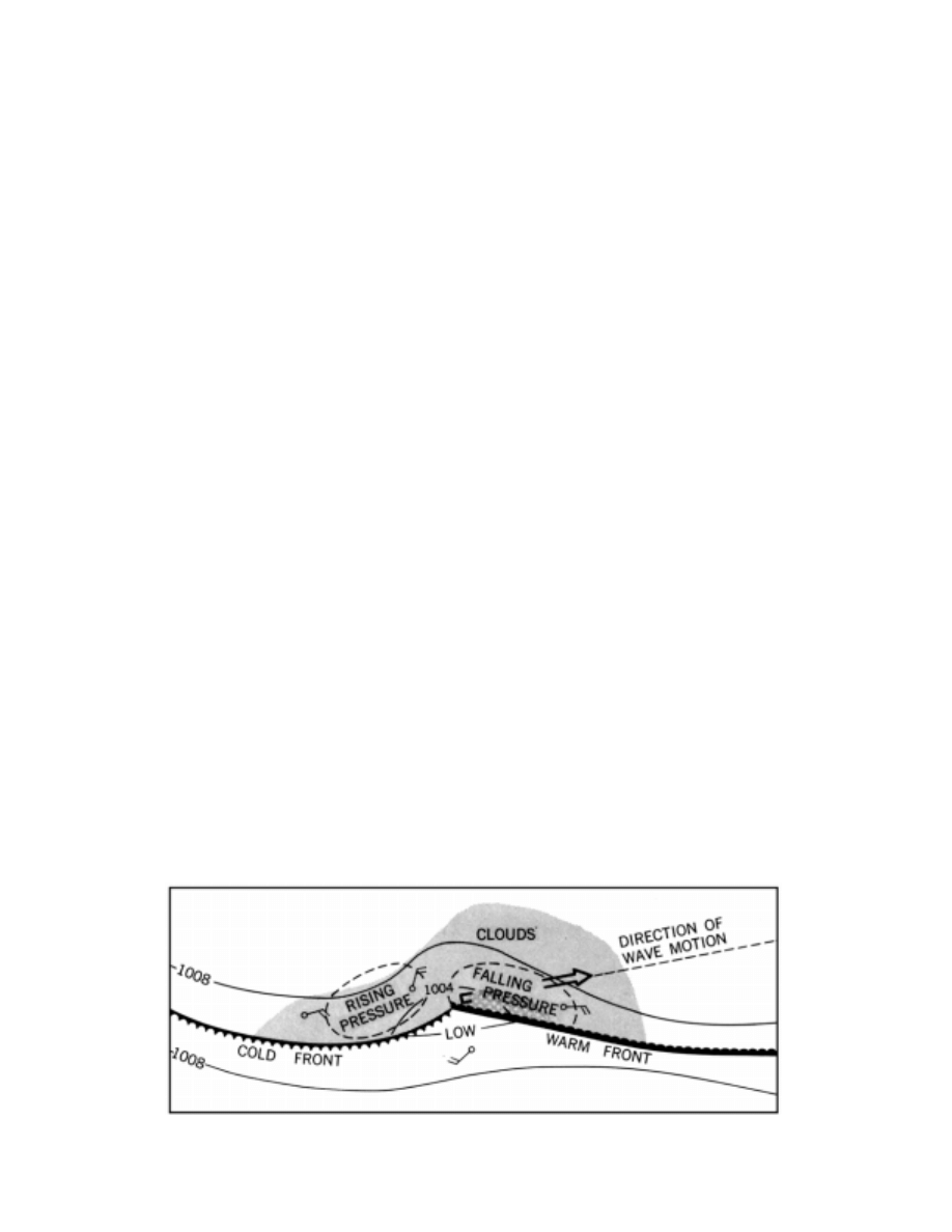
the colder air.The front may take on a wave-like charac-
ter,becoming a “frontal wave.”
Before the formation of frontal waves, the isobars (lines
of equal atmospheric pressure) tend to run parallel to the
fronts. As a wave is formed, the pattern is distorted some-
what, as shown in Figure 3510a. In this illustration, colder air
is north of warmer air. In Figures 3510a–3510d isobars are
drawn at 4-millibar intervals.
The wave tends to travel in the direction of the general
circulation, which in the temperate latitudes is usually in an
easterly and slightly poleward direction.
Along the leading edge of the wave, warmer air is re-
placing colder air. This is called the warm front. The
trailing edge is the cold front, where colder air is under-
running and displacing warmer air.
The warm air, being less dense, tends to ride up greatly
over the colder air it is replacing. Partly because of the re-
placement of cold, dense air with warm, light air, the
pressure decreases. Since the slope is gentle, the upper part
of a warm frontal surface may be many hundreds of miles
ahead of the surface portion. The decreasing pressure, indi-
cated by a “falling barometer,” is often an indication of the
approach of such a wave. In a slow-moving, well-devel-
oped wave, the barometer may begin to fall several days
before the wave arrives. Thus, the amount and nature of the
change of atmospheric pressure between observations,
called pressure tendency, is of assistance in predicting the
approach of such a system.
The advancing cold air, being more dense, tends to ride
under the warmer air at the cold front, lifting it to greater
heights. The slope here is such that the upper-air portion of
the cold front is behind the surface position relative to its
motion. After a cold front has passed, the pressure increas-
es, giving a rising barometer.
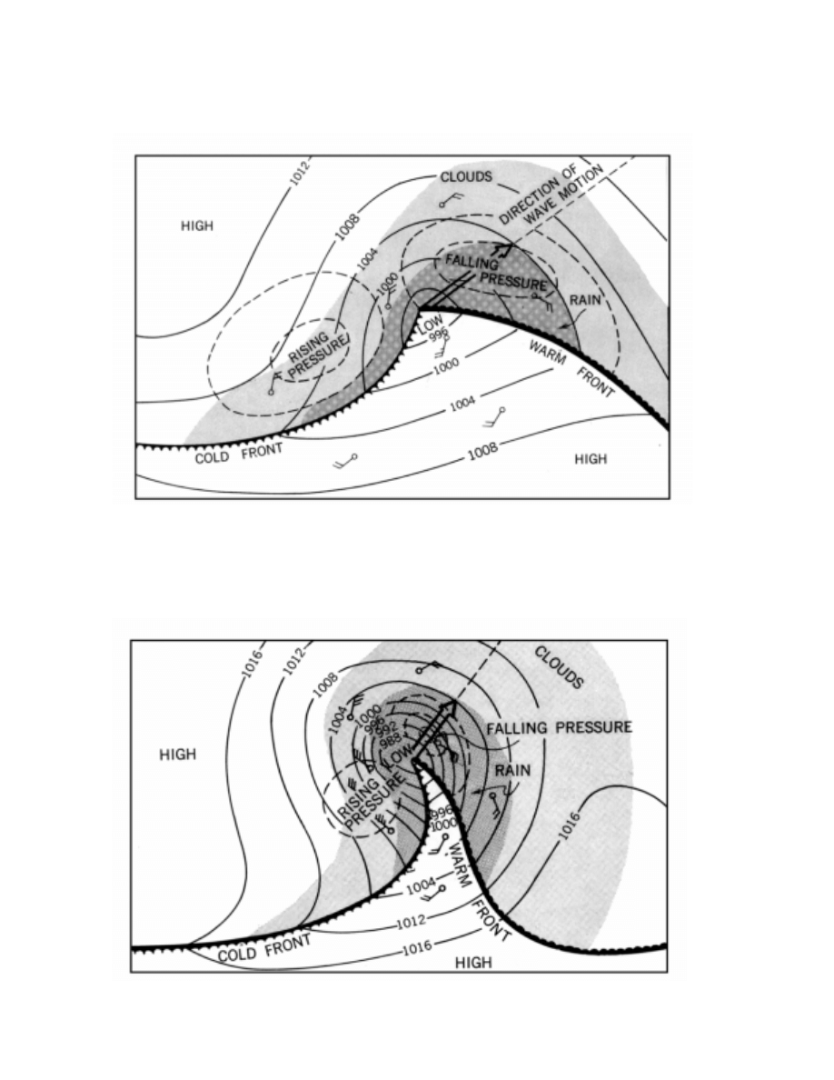
In the first stages, these effects are not marked, but as
the wave continues to grow, they become more pro-
nounced, as shown in Figure 3510b. As the amplitude of the
wave increases, pressure near the center usually decreases,
and the low is said to “deepen.” As it deepens, its forward
speed generally decreases.
The approach of a well-developed warm front (i.e.,
when the warm air is mT) is usually heralded not only by
falling pressure, but also by a more-or-less regular se-
quence of clouds. First, cirrus appear. These give way
successively to cirrostratus, altostratus, altocumulus, and
nimbostratus. Brief showers may precede the steady rain
accompanying the nimbostratus.
Figure 3510a. First stage in the development of a frontal wave (top view).
492
WEATHER ELEMENTS
Figure 3510b. A fully developed frontal wave (top view).
Figure 3510c. A frontal wave nearing occlusion (top view).
WEATHER ELEMENTS
493
As the warm front passes, the temperature rises, the
wind shifts clockwise (in the Northern Hemisphere), and the
steady rain stops. Drizzle may fall from low-lying stratus
clouds, or there may be fog for some time after the wind shift.
During passage of the warm sector between the warm front
and the cold front, there is little change in temperature or
pressure. However, if the wave is still growing and the low
deepening, the pressure might slowly decrease. In the warm
sector the skies are generally clear or partly cloudy, with cu-
mulus or stratocumulus clouds most frequent. The warm air
is usually moist, and haze or fog may often be present.
As the faster moving, steeper cold front passes, the wind
veers (shifts clockwise in the Northern Hemisphere counter-
clockwise in the Southern Hemisphere), the temperature falls
rapidly, and there are often brief and sometimes violent
squalls with showers, frequently accompanied by thunder
and lightning. Clouds are usually of the convective type. A
cold front usually coincides with a well-defined wind-shift
line (a line along which the wind shifts abruptly from south-
erly or southwesterly to northerly or northwesterly in the
Northern Hemisphere, and from northerly or northwesterly
to southerly or southwesterly in the Southern Hemisphere).
At sea a series of brief showers accompanied by strong, shift-
ing winds may occur along or some distance (up to 200
miles) ahead of a cold front. These are called squalls (in
common nautical use, the term squall may be additionally
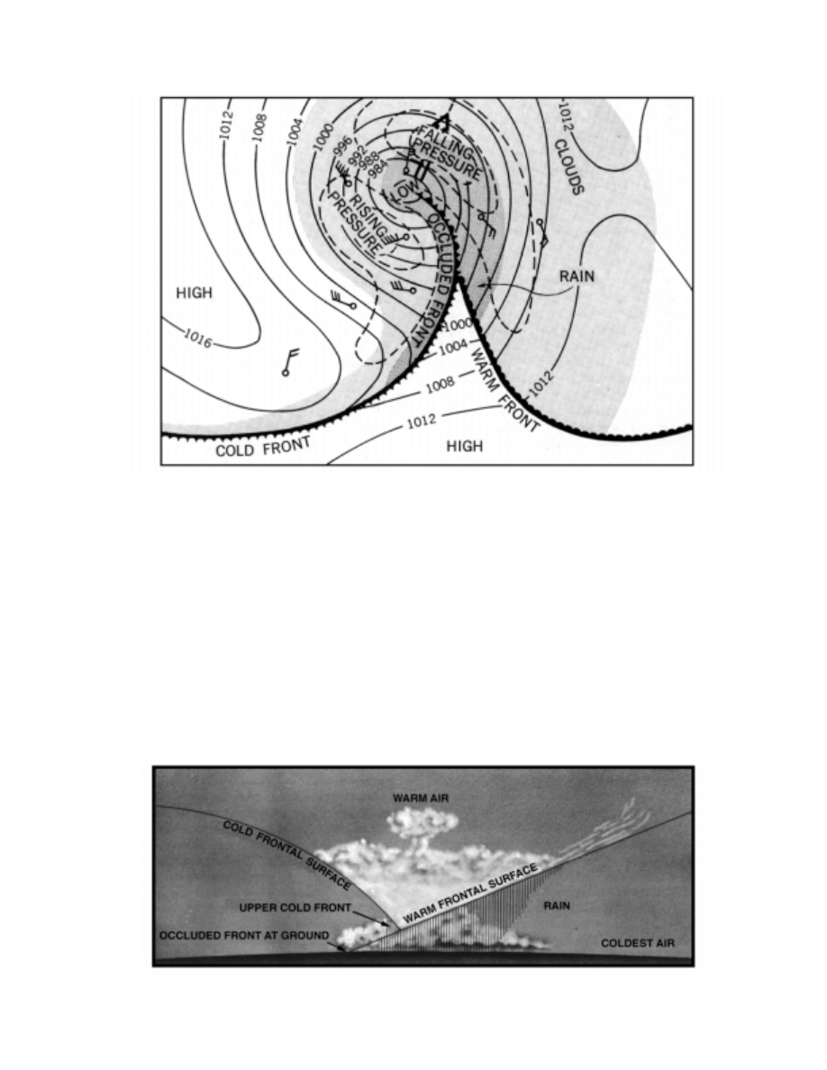
Figure 3510d. An occluded front (top view).
Figure 3510e. An occluded front (cross section).

494
WEATHER ELEMENTS
applied to any severe local storm accompanied by gusty
winds, precipitation, thunder, and lightning), and the line
along which they occur is called a squall line.
Because of its greater speed and steeper slope, which
may approach or even exceed the vertical near the earth’s
surface (due to friction), a cold front and its associated
weather pass more quickly than a warm front. After a cold
front passes, the pressure rises, often quite rapidly, the vis-
ibility usually improves, and the clouds tend to diminish.
Clear, cool or cold air replaces the warm hazy air.
As the wave progresses and the cold front approaches
the slower moving warm front, the low becomes deeper and
the warm sector becomes smaller, as shown in Figure 3510c.
Finally, the faster moving cold front overtakes the
warm front (Figure 3510d), resulting in an occluded front
at the surface, and an upper front aloft (Figure 3510e). When
the two parts of the cold air mass meet, the warmer portion
tends to rise above the colder part. The warm air continues
to rise until the entire frontal system dissipates. As the
warmer air is replaced by colder air, the pressure gradually
rises, a process called filling. This usually occurs within a
few days after an occluded front forms. Finally, there results
a cold low, or simply a low pressure system across which lit-
tle or no gradient in temperature and moisture can be found.
The sequence of weather associated with a low depends
greatly upon the observer’s location with respect to the path of
the center. That described above assumes that the low center
passes poleward of the observer. If the low center passes south
of the observer, between the observer and the equator, the
abrupt weather changes associated with the passage of fronts
are not experienced. Instead, the change from the weather char-
acteristically found ahead of a warm front, to that behind a cold
front, takes place gradually, the exact sequence dictated by dis-
tance from the center, and the severity and age of the low.
Although each low generally follows this pattern, no
two are ever exactly alike. Other centers of low pressure
and high pressure, and the air masses associated with them,
even though they may be 1,000 miles or more away, influ-
ence the formation and motion of individual low centers
and their accompanying weather. Particularly, a high stalls
or diverts a low. This is true of temporary highs as well as
semi-permanent highs, but not to as great a degree.
3511. Cyclones And Anticyclones
An area of relatively low pressure, generally circular,
is called a cyclone. Its counterpart for high pressure is
called an anticyclone. These terms are used particularly in
connection with the winds associated with such centers.
Wind tends to blow from an area of high pressure to one of
low pressure, but due to rotation of the earth, wind is de-
flected toward the right in the Northern Hemisphere and
toward the left in the Southern Hemisphere.
Because of the rotation of the earth, therefore, the cir-
culation tends to be counterclockwise around areas of low
pressure and clockwise around areas of high pressure in the
Northern Hemisphere, and the speed is proportional to the
spacing of isobars. In the Southern Hemisphere, the direc-
tion of circulation is reversed. Based upon this condition, a
general rule, known as Buys Ballot’s Law, or the Baric
Wind Law, can be stated:
If an observer in the Northern Hemisphere faces away
from the surface wind, the low pressure is toward his left;
the high pressure is toward his right.
If an observer in the Southern Hemisphere faces away
from the surface wind, the low pressure is toward his right;
the high pressure is toward his left.
In a general way, these relationships apply in the case
of the general distribution of pressure, as well as to tempo-
rary local pressure systems.
The reason for the wind shift along a front is that the
isobars have an abrupt change of direction along these lines.
Since the direction of the wind is directly related to the di-
rection of isobars, any change in the latter results in a shift
in the wind direction.
In the Northern Hemisphere, the wind shifts toward the
right (clockwise) when either a warm or cold front passes.
In the Southern Hemisphere, the shift is toward the left
(counterclockwise). When an observer is on the poleward
side of the path of a frontal wave, wind shifts are reversed
(i.e., to the left in the Northern Hemisphere and to the right
in the Southern Hemisphere).
In an anticyclone, successive isobars are relatively far
apart, resulting in light winds. In a cyclone, the isobars are
more closely spaced. With a steeper pressure gradient, the
winds are stronger.
Since an anticyclonic area is a region of outflowing winds,
air is drawn into it from aloft. Descending air is warmed, and as
air becomes warmer, its capacity for holding uncondensed
moisture increases. Therefore, clouds tend to dissipate. Clear
skies are characteristic of an anticyclone, although scattered
clouds and showers are sometimes encountered.
In contrast, a cyclonic area is one of converging winds.
The resulting upward movement of air results in cooling, a
condition favorable to the formation of clouds and precipi-
tation. More or less continuous rain and generally stormy
weather are usually associated with a cyclone.
Between the two hemispheric belts of high pressure as-
sociated with the horse latitudes, called subtropical
anticyclones, cyclones form only occasionally over certain
areas at sea, generally in summer and fall. Tropical cy-
clones (hurricanes and typhoons) are usually quite violent.
In the areas of the prevailing westerlies in temperate lati-
tudes, migratory cyclones (lows) and anticyclones (highs) are
a common occurrence. These are sometimes called extratropi-
cal cyclones and extratropical anticyclones to distinguish them
from the more violent tropical cyclones. Formation occurs
over sea and land. The lows intensify as they move poleward;
the highs weaken as they move equatorward. In their early
stages, cyclones are elongated, as shown in Figure 3510a, but
as their life cycle proceeds, they become more nearly circular
(Figure 3510b, Figure 3510c, and Figure 3510d).

WEATHER ELEMENTS
495
LOCAL WEATHER PHENOMENA
3512. Local Winds
In addition to the winds of the general circulation and
those associated with migratory cyclones and anticyclones,
there are numerous local winds which influence the weather
in various places.
The most common are the land and sea breezes, caused
by alternate heating and cooling of land adjacent to water.
The effect is similar to that which causes the monsoons, but
on a much smaller scale, and over shorter periods. By day
the land is warmer than the water, and by night it is cooler.
This effect occurs along many coasts during the summer.
Between about 0900 and 1100 local time the temperature of
the land becomes greater than that of the adjacent water.
The lower levels of air over the land are warmed, and the air
rises, drawing in cooler air from the sea. This is the sea
breeze. Late in the afternoon, when the sun is low in the
sky, the temperature of the two surfaces equalizes and the
breeze stops. After sunset, as the land cools below the sea
temperature, the air above it is also cooled. The contracting
cool air becomes more dense, increasing the pressure near
the surface. This results in an outflow of winds to the sea.
This is the land breeze, which blows during the night and
dies away near sunrise. Since the atmospheric pressure
changes associated with this cycle are not great, the accom-
panying winds generally do not exceed gentle to moderate
breezes. The circulation is usually of limited extent, reach-
ing a distance of perhaps 20 miles inland, and not more than
5 or 6 miles offshore, and to a height of a few hundred feet.
In the doldrums and subtropics, this process is repeated
with great regularity throughout most of the year. As the
latitude increases, it becomes less prominent, being masked
by winds of migratory cyclones and anticyclones. Howev-
er, the effect often may be present to reinforce, retard, or
deflect stronger prevailing winds.
Varying conditions of topography produce a large va-
riety of local winds throughout the world. Winds tend to
follow valleys, and to be deflected from high banks and
shores. In mountain areas wind flows in response to temper-
ature distribution and gravity. An anabolic wind is one that
blows up an incline, usually as a result of surface heating.
A katabatic wind is one which blows down an incline.
There are two types, foehn and fall wind.
The foehn (fãn) is a warm dry wind which initiates
from horizontally moving air encountering a mountain bar-
rier. As it blows upward to clear the mountains, it is cooled
below the dew point, resulting in clouds and rain on the
windward side. As the air continues to rise, its rate of cool-
ing is reduced because the condensing water vapor gives off
heat to the surrounding atmosphere. After crossing the
mountain barrier, the air flows downward along the leeward
slope, being warmed by compression as it descends to low-
er levels. Since it loses less heat on the ascent than it gains
during descent, and since it has lost its moisture during as-
cent, it arrives at the bottom of the mountains as very warm,
dry air. This accounts for the warm, arid regions along the
eastern side of the Rocky Mountains and in similar areas. In
the Rocky Mountain region this wind is known by the name
chinook. It may occur at any season of the year, at any hour
of the day or night, and have any speed from a gentle breeze
to a gale. It may last for several days, or for a very short pe-
riod. Its effect is most marked in winter, when it may cause
the temperature to rise as much as 20
°
F to 30
°
F within 15
minutes, and cause snow and ice to melt within a few hours.
On the west coast of the United States, a foehn wind, given
the name Santa Ana, blows through a pass and down a val-
ley of that name in Southern California. This wind is
frequently very strong and may endanger small craft imme-
diately off the coast.
A cold wind blowing down an incline is called a fall
wind. Although it is warmed somewhat during descent, as
is the foehn, it remains cold relative to the surrounding air.
It occurs when cold air is dammed up in great quantity on
the windward side of a mountain and then spills over sud-
denly, usually as an overwhelming surge down the other
side. It is usually quite violent, sometimes reaching hurri-
cane force. A different name for this type wind is given at
each place where it is common. The tehuantepecer of the
Mexican and Central American coast, the pampero of the
Argentine coast, the mistral of the western Mediterranean,
and the bora of the eastern Mediterranean are examples of
this wind.
Many other local winds common to certain areas have
been given distinctive names.
A blizzard is a violent, intensely cold wind laden with
snow mostly or entirely picked up from the ground, al-
though the term is often used popularly to refer to any
heavy snowfall accompanied by strong wind. A dust whirl
is a rotating column of air about 100 to 300 feet in height,
carrying dust, leaves, and other light material. This wind,
which is similar to a waterspout at sea, is given various lo-
cal names such as dust devil in southwestern United States
and desert devil in South Africa. A gust is a sudden, brief
increase in wind speed, followed by a slackening, or the vi-
olent wind or squall that accompanies a thunderstorm. A
puff of wind or a light breeze affecting a small area, such as
would cause patches of ripples on the surface of water, is
called a cat’s paw.
3513. Waterspouts
A waterspout is a small, whirling storm over ocean or
inland waters. Its chief characteristic is a funnel-shaped
cloud; when fully developed it extends from the surface of
the water to the base of a cumulus cloud. The water in a
waterspout is mostly confined to its lower portion, and may
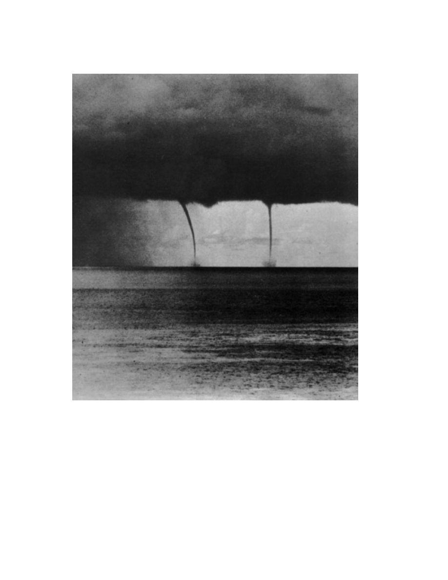
496
WEATHER ELEMENTS
be either salt spray drawn up by the sea surface, or freshwa-
ter resulting from condensation due to the lowered pressure
in the center of the vortex creating the spout. The air in wa-
terspouts may rotate clockwise or counterclockwise,
depending on the manner of formation. They are found
most frequently in tropical regions, but are not uncommon
in higher latitudes.
There are two types of waterspouts: those derived from
violent convective storms over land moving seaward,
called tornadoes, and those formed over the sea and which
are associated with fair or foul weather. The latter type is
most common, lasts a maximum of 1 hour, and has variable
strength. Many waterspouts are no stronger than dust whirl-
winds, which they resemble; at other times they are strong
enough to destroy small craft or to cause damage to larger
vessels, although modern ocean-going vessels have little to
fear.
Waterspouts vary in diameter from a few feet to several
hundred feet, and in height from a few hundred feet to sev-
eral thousand feet. Sometimes they assume fantastic
shapes; in early stages of development an hour glass shape
between cloud and sea is common. Since a waterspout is of-
ten inclined to the vertical, its actual length may be much
greater than indicated by its height.
Figure 3513. Waterspouts.
WEATHER ELEMENTS
497
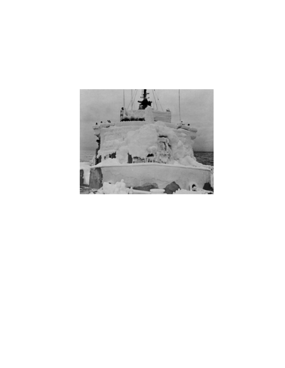
3514. Deck Ice
Ships traveling through regions where the air tempera-
ture is below freezing may acquire thick deposits of ice as
a result of salt spray freezing on the rigging, deckhouses,
and deck areas. This accumulation of ice is called ice accre-
tion. Also, precipitation may freeze to the superstructure
and exposed areas of the vessel, increasing the load of ice.
On small vessels in heavy seas and freezing weather, deck
ice may accumulate very rapidly and increase the topside weight
enough to capsize the vessel. Fishing vessels with outriggers, A-
frames, and other top hamper are particularly susceptible.
RESTRICTED VISIBILITY
3515. Fog
Fog is a cloud whose base is at the surface of the earth.
Fog is composed of droplets of water or ice crystals (ice
fog) formed by condensation or crystallization of water va-
por in the air.
Radiation fog forms over low-lying land on clear, calm
nights. As the land radiates heat and becomes cooler, it cools
the air immediately above the surface. This causes a temper-
ature inversion to form, the temperature increasing with
height. If the air is cooled to its dew point, fog forms. Often,
cooler and more dense air drains down surrounding slopes to
heighten the effect. Radiation fog is often quite shallow, and
is usually densest at the surface. After sunrise the fog may
“lift” and gradually dissipate, usually being entirely gone by
noon. At sea the temperature of the water undergoes little
change between day and night, and so radiation fog is sel-
dom encountered more than 10 miles from shore.
Advection fog forms when warm, moist air blows over
a colder surface and is cooled below its dew point. It is most
commonly encountered at sea, may be quite dense, and of-
ten persists over relatively long periods. Advection fog is
common over cold ocean currents. If the wind is strong
enough to thoroughly mix the air, condensation may take
place at some distance above the surface of the earth, form-
ing low stratus clouds rather than fog.
Off the coast of California, seasonal winds create an
offshore current which displaces the warm surface water,
causing an upwelling of colder water. Moist Pacific air is
transported along the coast in the same wind system, and is
cooled by the relatively cold water. Advection fog results.
In the coastal valleys, fog is sometimes formed when moist
air blown inland during the afternoon is cooled by radiation
during the night.
When very cold air moves over warmer water, wisps of
visible water vapor may rise from the surface as the water
Figure 3514. Deck ice.

498
WEATHER ELEMENTS
“steams,” In extreme cases this frost smoke, or Arctic sea
smoke, may rise to a height of several hundred feet, the por-
tion near the surface constituting a dense fog which
obscures the horizon and surface objects, but usually leaves
the sky relatively clear.
Haze consists of fine dust or salt particles in the air, too
small to be individually apparent, but in sufficient number to
reduce horizontal visibility and cast a bluish or yellowish veil
over the landscape, subduing its colors and making objects
appear indistinct. This is sometimes called dry haze to dis-
tinguish it from damp haze, which consists of small water
droplets or moist particles in the air, smaller and more scat-
tered than light fog. In international meteorological practice,
the term “haze” is used to refer to a condition of atmospheric
obscurity caused by dust and smoke.
Mist is synonymous with drizzle in the United States but
is often considered as intermediate between haze and fog in its
properties. Heavy mist can reduce visibility to a mile or less.
A mixture of smoke and fog is called smog. Normally
it is not a problem in navigation except in severe cases ac-
companied by an offshore wind from the source, when it
may reduce visibility to 2–4 miles.
ATMOSPHERIC EFFECTS ON LIGHT RAYS
3516. Mirage
Light is refracted as it passes through the atmosphere.
When refraction is normal, objects appear slightly elevated,
and the visible horizon is farther from the observer than it
otherwise would be. Since the effects are uniformly progres-
sive, they are not apparent to the observer. When refraction
is not normal, some form of mirage may occur. A mirage is
an optical phenomenon in which objects appear distorted,
displaced (raised or lowered), magnified, multiplied, or in-
verted due to varying atmospheric refraction which occurs
when a layer of air near the earth’s surface differs greatly in
density from surrounding air. This may occur when there is a
rapid and sometimes irregular change of temperature or hu-
midity with height.
If there is a temperature inversion (increase of temper-
ature with height), particularly if accompanied by a rapid
decrease in humidity, the refraction is greater than normal.
Objects appear elevated, and the visible horizon is farther
away. Objects which are normally below the horizon be-
come visible. This is called looming. If the upper portion of
an object is raised much more than the bottom part, the ob-
ject appears taller than usual, an effect called towering. If
the lower part of an object is raised more than the upper part,
the object appears shorter, an effect called stooping. When
the refraction is greater than normal, a superior mirage may
occur. An inverted image is seen above the object, and
sometimes an erect image appears over the inverted one,
with the bases of the two images touching. Greater than nor-
mal refraction usually occurs when the water is much colder
than the air above it.
If the temperature decrease with height is much greater
than normal, refraction is less than normal, or may even
cause bending in the opposite direction. Objects appear
lower than normal, and the visible horizon is closer to the
observer. This is called sinking. Towering or stooping may
occur if conditions are suitable. When the refraction is re-
versed, an inferior mirage may occur. A ship or an island
appears to be floating in the air above a shimmering hori-
zon, possibly with an inverted image beneath it. Conditions
suitable to the formation of an inferior mirage occur when
the surface is much warmer than the air above it. This usu-
ally requires a heated landmass, and therefore is more
common near the coast than at sea.
When refraction is not uniformly progressive, objects
may appear distorted, taking an almost endless variety of
shapes. The sun when near the horizon is one of the objects
most noticeably affected. A fata morgana is a complex mi-
rage characterized by marked distortion, generally in the
vertical. It may cause objects to appear towering, magni-
fied, and at times even multiplied.
3517. Sky Coloring
White light is composed of light of all colors. Color is
related to wavelength, the visible spectrum varying from
about 0.000038 to 0.000076 centimeters. The characteris-
tics of each color are related to its wavelength (or
frequency). The shorter the wavelength, the greater the
amount of bending when light is refracted. It is this princi-
ple that permits the separation of light from celestial bodies
into a spectrum ranging from red, through orange, yellow,
green, and blue, to violet, with long-wave infrared being
slightly outside the visible range at one end and short-wave
ultraviolet being slightly outside the visible range at the
other end. Light of shorter wavelength is scattered and dif-
fracted more than that of longer wavelength.
Light from the sun and moon is white, containing all col-
ors. As it enters the earth’s atmosphere, a certain amount of
it is scattered. The blue and violet, being of shorter wave-
length than other colors, are scattered most. Most of the
violet light is absorbed in the atmosphere. Thus, the scattered
blue light is most apparent, and the sky appears blue. At great
heights, above most of the atmosphere, it appears black.
When the sun is near the horizon, its light passes
through more of the atmosphere than when higher in the
sky, resulting in greater scattering and absorption of blue
and green light, so that a larger percentage of the red and or-
ange light penetrates to the observer. For this reason the sun
and moon appear redder at this time, and when this light

WEATHER ELEMENTS
499
falls upon clouds, they appear colored. This accounts for
the colors at sunset and sunrise. As the setting sun ap-
proaches the horizon, the sunset colors first appear as faint
tints of yellow and orange. As the sun continues to set, the
colors deepen. Contrasts occur, due principally to differ-
ence in height of clouds. As the sun sets, the clouds become
a deeper red, first the lower clouds and then the higher ones,
and finally they fade to a gray.
When there is a large quantity of smoke, dust, or other
material in the sky, unusual effects may be observed. If the
material in the atmosphere is of suitable substance and quan-
tity to absorb the longer wave red, orange, and yellow
radiation, the sky may have a greenish tint, and even the sun
or moon may appear green. If the green light, too, is ab-
sorbed, the sun or moon may appear blue. A green moon or
blue moon is most likely to occur when the sun is slightly be-
low the horizon and the longer wavelength light from the sun
is absorbed, resulting in green or blue light being cast upon
the atmosphere in front of the moon. The effect is most ap-
parent if the moon is on the same side of the sky as the sun.
3518. Rainbows
The rainbow, that familiar arc of concentric colored
bands seen when the sun shines on rain, mist, spray, etc., is
caused by refraction, internal reflection, and diffraction of
sunlight by the drops of water. The center of the arc is a point
180
°
from the sun, in the direction of a line from the sun,
through the observer. The radius of the brightest rainbow is
42
°
. The colors are visible because of the difference in the
amount of refraction of the different colors making up white
light, the light being spread out to form a spectrum. Red is on
the outer side and blue and violet on the inner side, with or-
ange, yellow, and green between, in that order from red.
Sometimes a secondary rainbow is seen outside the pri-
mary one, at a radius of about 50
°
. The order of colors of
this rainbow is reversed. On rare occasions a faint rainbow
is seen on the same side as the sun. The radius of this rain-
bow and the order of colors are the same as those of the
primary rainbow.
A similar arc formed by light from the moon (a lunar
rainbow) is called a moonbow. The colors are usually very
faint. A faint, white arc of about 39
°
radius is occasionally
seen in fog opposite the sun. This is called a fogbow, al-
though its origin is controversial, some considering it a
halo.
3519. Halos
Refraction, or a combination of refraction and reflec-
tion, of light by ice crystals in the atmosphere may cause a
halo to appear. The most common form is a ring of light of
radius 22
°
or 46
°
with the sun or moon at the center. Cirros-
tratus clouds are a common source of atmospheric ice
crystals. Occasionally a faint, white circle with a radius of
90
°
appears around the sun. This is called a Hevelian halo.
It is probably caused by refraction and internal reflection of
the sun’s light by bipyramidal ice crystals. A halo formed
by refraction is usually faintly colored like a rainbow, with
red nearest the celestial body, and blue farthest from it.
A brilliant rainbow-colored arc of about a quarter of a
circle with its center at the zenith, and the bottom of the arc
about 46
°
above the sun, is called a circumzenithal arc.
Red is on the outside of the arc, nearest the sun. It is pro-
duced by the refraction and dispersion of the sun’s light
striking the top of prismatic ice crystals in the atmosphere.
It usually lasts for only about 5 minutes, but may be so bril-
liant as to be mistaken for an unusually bright rainbow. A
similar arc formed 46
°
below the sun, with red on the upper
side, is called a circumhorizontal arc. Any arc tangent to a
heliocentric halo (one surrounding the sun) is called a tan-
gent arc. As the sun increases in elevation, such arcs tangent
to the halo of 22
°
gradually bend their ends toward each oth-
er. If they meet, the elongated curve enclosing the circular
halo is called a circumscribed halo. The inner edge is red.
A halo consisting of a faint, white circle through the
sun and parallel to the horizon is called a parhelic circle. A
similar one through the moon is called a paraselenic circle.
They are produced by reflection of sunlight or moonlight
from vertical faces of ice crystals.
A parhelion (plural: parhelia) is a form of halo con-
sisting of an image of the sun at the same altitude and some
distance from it, usually 22
°
, but occasionally 46
°
. A simi-
lar phenomenon occurring at an angular distance of 120
°
(sometimes 90
°
or 140
°
) from the sun is called a paranthe-
lion. One at an angular distance of 180
°
, a rare occurrence,
is called an anthelion, although this term is also used to re-
fer to a luminous, colored ring or glory sometimes seen
around the shadow of one’s head on a cloud or fog bank. A
parhelion is popularly called a mock sun or sun dog. Sim-
ilar phenomena in relation to the moon are called
paraselene (popularly a mock moon or moon dog),
parantiselene, and antiselene. The term parhelion should
not be confused with perihelion, the orbital point nearest the
sun when the sun is the center of attraction.
A sun pillar is a glittering shaft of white or reddish
light occasionally seen extending above and below the sun,
usually when the sun is near the horizon. A phenomenon
similar to a sun pillar, but observed in connection with the
moon, is called a moon pillar. A rare form of halo in which
horizontal and vertical shafts of light intersect at the sun is
called a sun cross. It is probably due to the simultaneous
occurrence of a sun pillar and a parhelic circle.
3520. Corona
When the sun or moon is seen through altostratus
clouds, its outline is indistinct, and it appears surrounded by
a glow of light called a corona. This is somewhat similar in
appearance to the corona seen around the sun during a solar
eclipse. When the effect is due to clouds, however, the glow
may be accompanied by one or more rainbow-colored rings

500
WEATHER ELEMENTS
of small radii, with the celestial body at the center. These can
be distinguished from a halo by their much smaller radii and
also by the fact that the order of the colors is reversed, red be-
ing on the inside, nearest the body, in the case of the halo, and
on the outside, away from the body, in the case of the corona.
A corona is caused by diffraction of light by tiny drop-
lets of water. The radius of a corona is inversely
proportional to the size of the water droplets. A large coro-
na indicates small droplets. If a corona decreases in size, the
water droplets are becoming larger and the air more humid.
This may be an indication of an approaching rainstorm. The
glow portion of a corona is called an aureole.
3521. The Green Flash
As light from the sun passes through the atmosphere, it
is refracted. Since the amount of bending is slightly different
for each color, separate images of the sun are formed in each
color of the spectrum. The effect is similar to that of imper-
fect color printing, in which the various colors are slightly out
of register. However, the difference is so slight that the effect
is not usually noticeable. At the horizon, where refraction is
maximum, the greatest difference, which occurs between vi-
olet at one end of the spectrum and red at the other, is about
10 seconds of arc. At latitudes of the United States, about 0.7
second of time is needed for the sun to change altitude by this
amount when it is near the horizon. The red image, being
bent least by refraction, is first to set and last to rise. The
shorter wave blue and violet colors are scattered most by the
atmosphere, giving it its characteristic blue color. Thus, as
the sun sets, the green image may be the last of the colored
images to drop out of sight. If the red, orange, and yellow im-
ages are below the horizon, and the blue and violet light is
scattered and absorbed, the upper rim of the green image is
the only part seen, and the sun appears green. This is the
green flash. The shade of green varies, and occasionally the
blue image is seen, either separately or following the green
flash (at sunset). On rare occasions the violet image is also
seen. These colors may also be seen at sunrise, but in reverse
order. They are occasionally seen when the sun disappears
behind a cloud or other obstruction.
The phenomenon is not observed at each sunrise or sun-
set, but under suitable conditions is far more common than
generally supposed. Conditions favorable to observation of
the green flash are a sharp horizon, clear atmosphere, a tem-
perature inversion, and a very attentive observer. Since these
conditions are more frequently met when the horizon is
formed by the sea than by land, the phenomenon is more
common at sea. With a sharp sea horizon and clear atmo-
sphere, an attentive observer may see the green flash at as
many as 50 percent of sunsets and sunrises, although a tele-
scope may be needed for some of the observations.
Duration of the green flash (including the time of blue
and violet flashes) of as long as 10 seconds has been reported,
but such length is rare. Usually it lasts for a period of about
1
/
2
to 2
1
/
2
seconds, with about 1
1
/
4
seconds being average.
This variability is probably due primarily to changes in the
index of refraction of the air near the horizon.
Under favorable conditions, a momentary green flash
has been observed at the setting of Venus and Jupiter. A
telescope improves the chances of seeing such a flash from
a planet, but is not a necessity.
3522. Crepuscular Rays
Crepuscular rays are beams of light from the sun
passing through openings in the clouds, and made visible by
illumination of dust in the atmosphere along their paths.
Actually, the rays are virtually parallel, but because of per-
spective, appear to diverge. Those appearing to extend
downward are popularly called backstays of the sun, or the
sun drawing water. Those extending upward and across the
sky, appearing to converge toward a point 180
°
from the
sun, are called anticrepuscular rays.
THE ATMOSPHERE AND RADIO WAVES
3523. Atmospheric Electricity
Radio waves traveling through the atmosphere exhibit
many of the properties of light, being refracted, reflected,
diffracted, and scattered. These effects are discussed in
greater detail in Chapter 10, Radio Waves in Navigation.
Various conditions induce the formation of electrical
charges in the atmosphere. When this occurs, there is often
a difference of electron charge between various parts of the
atmosphere, and between the atmosphere and earth or ter-
restrial objects. When this difference exceeds a certain
minimum value, depending upon the conditions, the static
electricity is discharged, resulting in phenomena such as
lightning or St. Elmo’s fire.
Lightning is the discharge of electricity from one part
of a thundercloud to another, between different clouds, or
between a cloud and the earth or a terrestrial object.
Enormous electrical stresses build up within thunder-
clouds, and between such clouds and the earth. At some point
the resistance of the intervening air is overcome. At first the
process is a progressive one, probably starting as a brush dis-
charge (St. Elmo’s fire), and growing by ionization. The
breakdown follows an irregular path along the line of least re-
sistance. A hundred or more individual discharges may be
necessary to complete the path between points of opposite
polarity. When this “leader stroke” reaches its destination, a
heavy “main stroke” immediately follows in the opposite di-
rection. This main stroke is the visible lightning, which may

WEATHER ELEMENTS
501
be tinted any color, depending upon the nature of the gases
through which it passes. The illumination is due to the high
degree of ionization of the air, which causes many of the at-
oms to become excited and emit radiation.
Thunder, the noise that accompanies lightning, is
caused by the heating and ionizing of the air by lightning,
which results in rapid expansion of the air along its path and
the sending out of a compression wave. Thunder may be
heard at a distance of as much as 15 miles, but generally does
not carry that far. The elapsed time between the flash of light-
ning and reception of the accompanying sound of thunder is
an indication of the distance, because of the difference in
travel time of light and sound. Since the former is compara-
tively instantaneous, and the speed of sound is about 1,117
feet per second, the approximate distance in nautical miles is
equal to the elapsed time in seconds, divided by 5.5. If the
thunder accompanying lightning cannot be heard due to its
distance, the lightning is called heat lightning.
St. Elmo’s fire is a luminous discharge of electricity
from pointed objects such as the masts and antennas of
ships, lightning rods, steeples, mountain tops, blades of
grass, human hair, arms, etc., when there is a considerable
difference in the electrical charge between the object and
the air. It appears most frequently during a storm. An object
from which St. Elmo’s fire emanates is in danger of being
struck by lightning, since this discharge may be the initial
phase of the leader stroke. Throughout history those who
have not understood St. Elmo’s fire have regarded it with
superstitious awe, considering it a supernatural manifesta-
tion. This view is reflected in the name corposant (from
“corpo santo,” meaning “body of a saint”) sometimes given
this phenomenon.
The aurora is a luminous glow appearing in varied forms
in the thin atmosphere high above the earth in high latitudes. It
closely follows solar flare activity, and is believed caused by the
excitation of atoms of oxygen and hydrogen, and molecules of
nitrogen (N
2
). Auroras extend across hundreds of kilometers of
sky, in colored sheets, folds, and rays, constantly changing in
form and color. On occasion they are seen in temperate or even
more southern latitudes. The maximum occurrence is at about
64–70
°
of geomagnetic latitude. These are called the auroral
zones in both northern and southern regions.
The aurora of the northern regions is the Aurora Bore-
alis or northern lights, and that of the southern region the
Aurora Australis, or southern lights. The term polar
lights is occasionally used to refer to either.
In the northern zone, there is an apparent horizontal
motion to the westward in the evening and eastward in the
morning; a general southward motion occurs during the
course of the night.
Variation in auroral activity occurs in sequence with the 11-
year sunspot cycle, and also with the 27-day period of the sun’s
synodical rotation. Daily occurrence is greatest near midnight.
WEATHER ANALYSIS AND FORECASTING
3524. Forecasting Weather
The prediction of weather at some future time is based
upon an understanding of weather processes, and observa-
tions of present conditions. Thus, when there is a certain
sequence of cloud types, rain usually can be expected to fol-
low. If the sky is cloudless, more heat will be received from
the sun by day, and more heat will be radiated outward from
the warm earth by night than if the sky is overcast. If the
wind is from a direction that transports warm, moist air over
a colder surface, fog can be expected. A falling barometer
indicates the approach of a “low,” probably accompanied
by stormy weather. Thus, before meteorology passed from
an “art” to “science,” many individuals learned to interpret
certain atmospheric phenomena in terms of future weather,
and to make reasonably accurate forecasts for short periods
into the future.
With the establishment of weather observation sta-
tions, continuous and accurate weather information became
available. As observations expanded and communication
techniques improved, knowledge of simultaneous condi-
tions over wider areas became available. This made
possible the collection of “synoptic” reports at civilian and
military forecast centers.
Individual observations are made at stations on shore
and aboard vessels at sea. Observations aboard merchant
ships at sea are made and transmitted on a voluntary and co-
operative basis. The various national meteorological
services supply shipmasters with blank forms, printed in-
structions, and other materials essential to the making,
recording, and interpreting of observations. Any shipmaster
can render a particularly valuable service by reporting all
unusual or non-normal weather occurrences.
Symbols and numbers are used to indicate on a synop-
tic chart, popularly called a weather map, the conditions at
each observation station. Isobars are drawn through lines of
equal atmospheric pressure, fronts are located and symbol-
ically marked (See Figure 3525), areas of precipitation and
fog are indicated, etc.
Ordinarily, weather maps for surface observations are
prepared every 6 (sometimes 3) hours. In addition, synoptic
charts for selected heights are prepared every 12 (some-
times 6) hours. Knowledge of conditions aloft is of value in
establishing the three-dimensional structure and motion of
the atmosphere as input to the forecast.
With the advent of the digital computer, highly sophis-
ticated numerical models have been developed to analyze
and forecast weather patterns. The civil and military weather
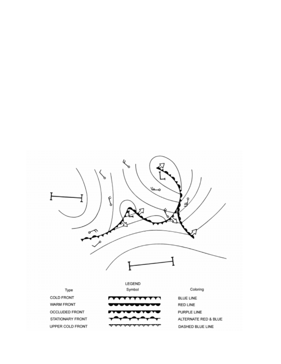
502
WEATHER ELEMENTS
centers prepare and disseminate vast numbers of weather
charts (analyses and prognoses) daily to assist local forecast-
ers in their efforts to provide users with accurate weather
forecasts. The accuracy of forecast decreases with the length
of the forecast period. A 12-hour forecast is likely to be
more reliable than a 24-hour forecast. Long term forecasts
for 2 weeks or a month in advance are limited to general
statements. For example, a prediction may be made about
which areas will have temperatures above or below normal,
and how precipitation will compare with normal, but no at-
tempt is made to state that rainfall will occur at a certain time
and place.
Forecasts are issued for various areas. The national me-
teorological services of most maritime nations, including the
United States, issue forecasts for ocean areas and warnings of
approaching storms. The efforts of the various nations are co-
ordinated through the World Meteorological Organization.
3525. Weather Forecast Dissemination
Dissemination of weather information is carried out in
a number of ways. Forecasts are widely broadcast by com-
mercial and government radio stations and printed in
newspapers. Shipping authorities on land are kept informed
by telegraph and telephone. Visual storm warnings are dis-
played in various ports, and storm warnings are broadcast
by radio.
Through the use of codes, a simplified version of syn-
optic weather charts is transmitted to various stations
ashore and afloat. Rapid transmission of completed maps is
accomplished by facsimile. This system is based upon de-
tailed scanning, by a photoelectric detector, of illuminated
black and white copy. The varying degrees of light intensity
are converted to electric energy, which is transmitted to the
receiver and converted back to a black and white presenta-
tion. The proliferation of both commercial and restricted
computer bulletin board systems having weather informa-
tion has also greatly increased the accessibility of
environmental data.
Complete information on dissemination of weather in-
formation by radio is provided in Selected Worldwide
Marine Weather Broadcasts, published jointly by the Na-
Figure 3525. Designation of fronts on weather maps.

WEATHER ELEMENTS
503
tional Weather Service and the Naval Meteorology and
Oceanography Command. This publication lists broadcast
schedules and weather codes. Information on day and night
visual storm warnings is given in the various volumes of
Sailing Directions (Enroute), and (Planning Guide).
3526. Interpreting Weather
The factors which determine weather are numerous
and varied. Ever-increasing knowledge regarding them
makes possible a continually improving weather service.
However, the ability to forecast is acquired through study
and long practice, and therefore the services of a trained
meteorologist should be utilized whenever available.
The value of a forecast is increased if one has access to
the information upon which it is based, and understands the
principles and processes involved. It is sometimes as im-
portant to know the various types of weather which may be
experienced as it is to know which of several possibilities is
most likely to occur.
At sea, reporting stations are unevenly distributed,
sometimes leaving relatively large areas with incomplete
reports, or none at all. Under these conditions, the locations
of highs, lows, fronts, etc., are imperfectly known, and their
very existence may even be in doubt. At such times the mar-
iner who can interpret the observations made from his own
vessel may be able to predict weather for the next several
hours more reliably than a trained meteorologist ashore.

Document Outline
- Chapter 35
Wyszukiwarka
Podobne podstrony:
CHAPT37 weather obs
islcollective worksheets preintermediate a2 elementary school spelling weather s the weather like 25
islcollective worksheets beginner prea1 elementary school speaking weather ac eather and countries 2
islcollective worksheets beginner prea1 elementary a1 preintermediate a2 elementary sc the weather 2
Wyk 02 Pneumatyczne elementy
Elementy prawa prawo administracyjne
7 Mikro i makro elementy naszej diety
Wykład 4 Elementarne zagadnienia kwantowe
Elementy klimatu
7 Sposób montażu charakterystycznych elementów
Elementy fizyki jądrowej
Doradztwo i jego prawny element procesu decyzyjnego
Podział chorób nerek z elementami patofizjologii
Praca zespolowa z elementami komunikacji interpersonalnej ed wczesn
3 Elementy prawa O Przyrody
więcej podobnych podstron