
zooplankton in the subantarctic represents 55 g m
⫺3
between 0 and 50 m
depth. Around South Georgia, the relationship between the density of
phytoplankton and zooplankton is inverse (Knox, 1970). Copepods
reach maximum densities at around 600 m depth, decreasing continu-
ously toward the surface. The main species of zooplankton are
Euphausia superba, Euphausia frigida, Thysanoessa spp., Parathemisto
spp., and Salpa fusiformis. The main krill biomass is observed in areas
of the island arc. The complicated underwater relief and coastline of
this area leads to the formation of numerous gyres and local eddy cur-
rents trapping the krill (Makarov et al., 1970).
Krill has been found to be an important part of the diet of numerous
fish living around the islands, including members of the families
Rajidae, Paralepidae, Myctophidae, Scopelarchidae, Muraenolepidae,
Gadidae, Moridae, Macruridae. The occurrence of various fish in the
epipelagic waters of the Scotia Arc Islands, which are described by
many authors as a highly productive krill zone, are also profitable to
whales, seals, birds, and Antarctic fishes, but also to subantarctic and
subtropical epipelagic species of the southern hemisphere. The
crabeater, leopard, Ross and some other seals can be found in the Scotia
Arc Islands.
Annie Mercier and Jean-François Hamel
Bibliography
Bird, E.C.F., 1985. Atlantic Ocean Islands. In Bird, E.C.F. and
Schwartz, M. (eds.), The World’s Coastline. New York: Van
Nostrand Reinhold, pp. 1035–1039.
Blindheim, J., 1989. Ecological features of the Norwegian Sea. In
Proceedings of the sixth conference of the Comité Arctique
International. Leiden: E.J. Brill, pp. 366–401.
Braarud, T., Ringdal Gaarder, K., and Nordli, O., 1958. Seasonal
changes in the phytoplankton at various points of the Norwegian
west coast. Fiskeridirektoratet Skrifter Serie Havundersoekelser,
12: 77.
Coltman, D.W., Bowen, W.D., and Wright, J.M., 1999. A multivariate
analysis of phenotype and paternity in male harbor seals, Phoca vit-
ulina, at Sable Island, Nova Scotia. Behavioral Ecology, 10: 169–177.
Day, R.W., 1983. Effects of benthic algae on sessile animals: observa-
tional evidence from coral reef habitats. Bulletin of Marine Science,
33: 597–605.
Falcon, J.M., Brito, S.A., and Bundrick, C.M., 1996. Structure of and
relationships within and between the littoral, rock-substrate fish
communities off four islands in the Canarian Archipelago. Marine
Biology, 125: 215–231.
Knox, G.A., 1970. Antarctic marine ecosystems. In Holdgate, M.W.
(ed.), Antarctic Ecology. London: Academic Press, pp. 69–96.
Lorenzo, J.A., 1995. Habitat use of wintering waders in the coast of El
Medano (Tenerife,
Canary Islands).
Miscellania Zoologica,
Barcelona, 18: 153–160.
Makarov, R.R., Naumov, A.G., and Shevtsov, V.V., 1970. The biology
and distribution of the Antarctic krill. In Holdgate, M.W. (ed.),
Antarctic Ecology Vol. I. London: Academic Press, pp. 173–176.
Manning, R.B., and Fenner, A.C., 1990. Decapod and Stomatopod
Crustacea from Ascension Island,
South Atlantic Ocean.
Smithsonian Contributions to Zoology, Washington: Smithsonian
Institution Press, 503, p. 91.
Morris, B., Barnes, J., Brown, F., and Markham, J., 1977. The Bermuda
Marine Environment. A Report of the Bermuda Inshore Waters
Investigations 1976–1977. St. George West, Bermuda: Bermuda
Biological Station Special Publication No. 15.
Neto, A.I., and Avila, S.P., 1999. Subtidal algal communities and their
associated molluscan fauna in Sao Vicente Bay (Sao Miguel,
Azores). Abstracts of the 34th European Marine Biology Symposium,
Ponta Delgada, Azores, p. 7.
Ojeda, A., 1996. Phytoplanktonic biomass and chlorophyll a in western
Canary Islands. Oceanographia y Recursos Marinos en El Atlantico
Centro-Oriental, ICCM, pp. 91–121.
M
M
Pawson, D.L., 1978. The echinoderm fauna of Ascension Island, South
Atlantic Ocean. Smithsonian Contributions to the Marine Sciences,
Washington: Smithsonian Institution Press.
Price, J.H. and John, D.M., 1978. Subtidal ecology in Antigua and
Ascension: A comparaison. Progress in Underwater Science Report
of the Underwater Association, New Series, 3: 111–133.
Stephenson, T.A. and Stephenson, A., 1972. Life between Tidemarks
on Rocky Shores. W.H. Freeman and Company, New York: pp.
81–96.
Williamson, M., 1981. Island Populations. Oxford University Press, UK.
Wirtz, P., 1999. New records of coastal marine animals from Madeira
and from the Azores, and their zoogeographical interpretation.
Abstracts of the 34th European Marine Biology Symposium, Ponta
Delgada, Azores, p. 9.
Zernova, V.V., 1970. Phytoplankton of the Southern Ocean. In
Holdgate, M.W. (ed.), Antarctic Ecology. London: Academic Press,
pp. 137–142.
Cross-references
Arctic, Coastal Ecology
Antarctic, Coastal Ecology and Geomorphology
Atlantic Ocean Islands, Coastal Geomorphology
Caribbean Islands, Coastal Ecology and Geomorphology
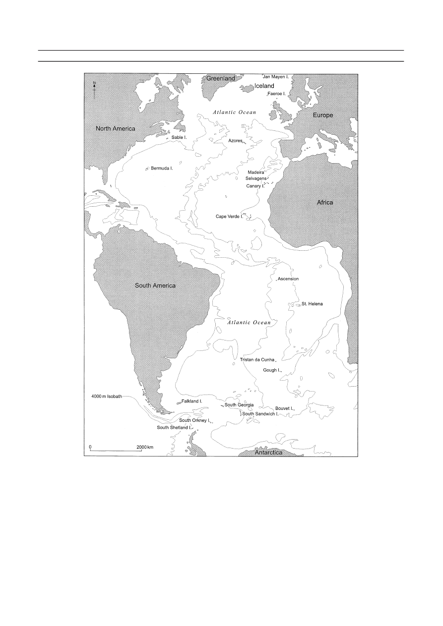
ATLANTIC OCEAN ISLANDS, COASTAL
GEOMORPHOLOGY
From south to north, the islands of the Atlantic covered here include
the Scotia Arc (South Shetland, South Orkney, South Sandwich, and
South Georgia), Bouvet, the Falklands, Tristan da Cunha and Gough,
St. Helena and Ascension, Macronesia (Cape Verde, Canaries, Madiera,
and Azores), Bermuda, Sable, Faeroes, and Jan Mayen (Figure A60).
The Caribbean islands, Iceland, Great Britain, and Ireland are covered
elsewhere.
Setting
With only a few exceptions such as Bermuda and Sable, it is clear from
the spatial distribution of almost all of the other individual islands or
island groups in the Atlantic Ocean that most owe both their location
and coastal morphology to a turbulent tectonic and often volcanic past.
The tectonic opening of the Atlantic Ocean is the key factor in this his-
tory. Commencing in the Late Jurassic some 140 million years ago and
fully open some 65 million years ago (Hansom and Gordon, 1998), the
Atlantic basin is characterized by the westward movement of both
American plates and the eastward movement of the African and
Eurasian plates. Basaltic magma upwelling into the crustal gap in the
mid-ocean spreading center has over time produced a long submarine
ridge composed of a series of fissure volcanoes known as the mid-
Atlantic Ridge. In places the volume of upwelling magma has been suf-
ficient to allow the construction of volcanoes that extend to the ocean
surface and form the individual volcanic islands and island groups of
Bouvet, Gough, Tristan da Cunha, St. Helena, Ascension, Macronesia,
Kelard, and Jan Mayen. Elsewhere, where more than two plates and
spreading directions are involved, this relatively simple mid-Atlantic
geometry is more complex. For example, the development of the Scotia
Arc in the South Atlantic was contingent on the opening of the Drake
Passage and the eastward movement of several micro-plates along a
progressively elongating arc. The boundaries of the Scotia Arc are
marked in the south by the South Shetland and South Orkney Islands,
in the north by South Georgia and in the east by the still-extending vol-
canic island arc of the South Sandwich Islands (Hansom and Gordon,
1998). As a result, the rocks of South Georgia, South Shetlands, and
South Orkney are mainly composed of fragments of older rocks and
intruded volcanics, most of which were created elsewhere and subse-
quently transported to their present sites. By contrast, 70% of the rocks
of the South Sandwich Islands are recently extruded basalts (Baker,
1990).
This tectonic and volcanic past has also ensured that, with exception
of parts of the Scotia Arc in the South Atlantic and Bermuda and Sable
Island in the North Atlantic, almost all of the remaining mid-ocean
islands are of volcanic origin (Bird, 1985a, b). Many remain as active
volcanoes that rise from deep water and their coastlines are mainly
characterized by steep cliffs cut into lava, ash or hyaloclastite. Since
many of the volcanoes themselves are youthful, the coastlines are also
young and in a state of continuing adjustment in response to marine
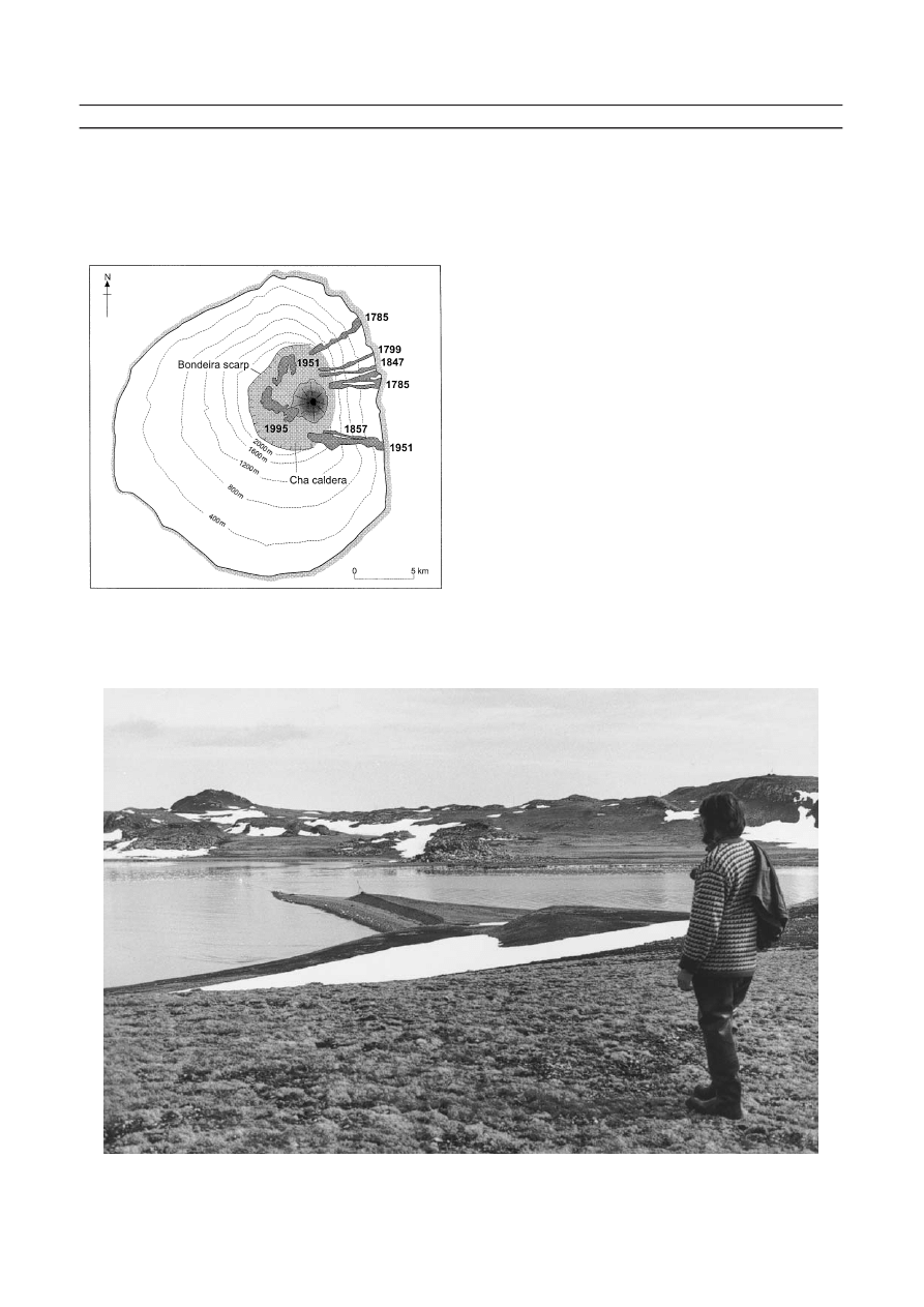
activity and ongoing volcanic events. For example, Fogo, in the Cape
Verdes, is an active stratovolcano with a symmetrical cone rising out of
the ocean (Figure A61). Its slopes are composed mainly of subaerial
lava flows, some of which are dated, and all of which end in marine
cliffs, sometimes with small cliff-foot beaches composed of basalt boul-
ders and gravels.
88
ATLANTIC OCEAN ISLANDS, COASTAL GEOMORPHOLOGY
ATLANTIC OCEAN ISLANDS, COASTAL GEOMORPHOLOGY
89
Figure A60 Location of the Atlantic Ocean Islands.
The Scotia Arc
Like most Antarctic coasts, the coasts of the Scotia Arc islands are
mainly cliffed and rocky. Many of the cliffs are cut in glacier ice and
beaches are regionally rare (Hansom and Gordon, 1998). Rapid cliff
retreat rates of 1 cm a
⫺1
have been calculated for the cliffs of Fildes
Peninsula in the South Shetland Islands and are thought to be the result
of efficient frost shattering (Hansom, 1983a). Since all of these coasts
are affected by sea ice for up to eight months of the year, the more
normal coastal processes associated with wave and tide operate inter-
mittently and often in conjunction with floating ice fragments (Hansom
and Kirk, 1989). This means that the relative order associated with wave
processes is annually swept away and replaced by the bulldozing
and grinding action of floating ice so that beach sediment is moved in
a nonselective way to produce disorganized fabrics and landforms.
In the South Shetland Islands much of the coast is either rock or ice-
cliff, although some glacier termini rest on a low rocky platform at sea
level. There are important exceptions, however, and significant beach
development occurs on the peninsulas that protrude beyond the ice
cover. The Fildes and Byers Peninsulas on King George Island and
Livingston Island, respectively, are adorned with extensive emerged
beach deposits, some of which connect offshore islets and skerries to the
shore platforms of the main island (Figure A62). Prominent shore plat-
forms occur at sea level and at altitudes of 3–8 m, 11–17 m, 28–50 m
and 85–100 m above sea level and are cut into a variety of rock types
(Hansom, 1983a). Although gravel beaches are found up to 200 m
ramp-like platforms in more exposed locations, Hansom (1983a) related
their development to the interplay between the frequency of floating ice
blocks that horizontally abrade the surface and wave activity that pro-
duces ramps. The upper part of the sub-horizontal platforms within
sheltered bays is often adorned with an undulating layer of boulders
that have been smoothed and compacted into extensive boulder pave-
ments by the action of floating ice blocks (see Boulder Pavement)
(Hansom, 1983b). Three of the islands, Penguin, Bridgeman, and
Deception, are relatively new and active volcanoes and erosion of the
friable rocks of the outer coast has produced cliffs of a variety of
heights. The inner crater of Deception Island has been inundated by the
sea and has several sand and gravel beaches that are frequented by pen-
guins and tourists alike, in sharp contrast to the steep rocky outer coast.
Whereas the extensive beaches of parts of the South Shetland Islands
allow for easy landing for both wildlife and boats, the coastline of the
South Orkney Islands is more formidable. Three of the four largest
islands, Coronation, Powell, and Laurie are dominated by large perma-
nent ice caps spilling down steep rocky cliffs which plunge below sea
level. A few bouldery beaches occur, for example, on Laurie Island.
The remaining island, Signy is characterized by ancient schists and
amphibolites that have been glacially scoured to produce a relatively
low and rolling coastal plain with a rocky sloping shore albeit with only
a few bouldery beaches. The coast of the South Sandwich Islands is as
inhospitable as that of South Orkney, since only a small proportion
of land is free of ice and there are few beaches or easy landing points.
The South Sandwich group consists of a 400-km-long volcanic island
arc caused by the subduction of the South Sandwich plate beneath the
South American plate. Rising from an 8,428 m-deep ocean trench, the
eleven main islands are all volcanoes made up of 60% lava and 40%
tephra (Baker, 1990). The coastline is steep and cliffed but because
many of the islands are still active volcanoes, erosion of softer tephras
has produced a crenulate coastline with infrequent small bouldery
beaches. All of the islands except Zavodovski are characterized by reefs
and skerries and these are especially well-developed between smaller
island clusters, such as in the extreme south at Thule, Cook and
Bellingshausen islands. Low altitude bare coastal plains do occur on
some islands, such as Zavodovski and Bellingshausen, but few scientists
90
ATLANTIC OCEAN ISLANDS, COASTAL GEOMORPHOLOGY
Figure A61 The island of Fogo, Cape Verde group is an active
volcano and has a steep coast that is characteristic of many of the
Mid-Atlantic Islands. 18–20th century lavaflows indicated as map.
Figure A62 Ardley Island, in the South Shetland Islands, is connected to one of the main islands by an intertidal sand tombolo and is
adorned with raised beaches whose altitudes are the same as those on the adjacent islands.
above sea level the most extensive are sited on the lower shore platforms
at altitudes of 2.5–3 m, 5.50–6 m, 8–10.5 m, 12–13.5 m, and 16.5–18.5 m
above sea level, as well as at present sea level (John and Sugden, 1971;
Hansom, 1983a). Since the extensive sub-horizontal shore platforms
that occur at present sea level in sheltered locations give way to steeper,
have investigated these islands and so, the nature of the plains is
unknown. In the strong westerly ocean circulation of the Scotia Sea,
pumice from South Sandwich is known to travel great distances.
The pumice from a submarine eruption close to Zavodovski Island in
March 1962 reached the beaches of New Zealand in late 1963, having
been transported east within the Antarctic Circumpolar Current at
11–17 cm s
⫺1
(Hansom and Gordon, 1998).
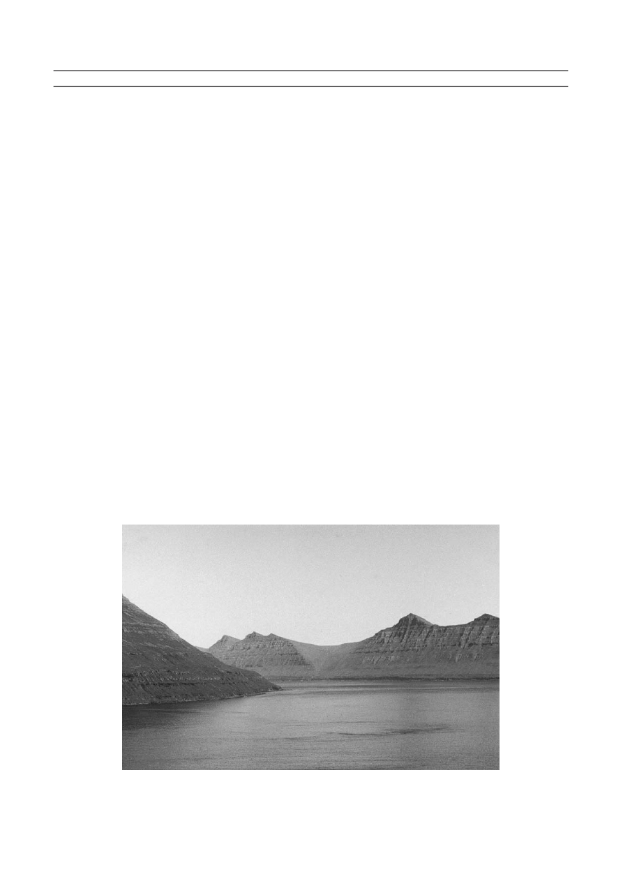
South Georgia on the northern limb of the Scotia Arc, is a 170-km-
long and 40-km-wide sequence of volcaniclastic sediments folded into a
mountain range that rises out of the Atlantic Ocean to heights of over
2,700 m. It is not volcanically active but is heavily glacierized and has all
the characteristics of a glacially eroded coastal fold mountain range.
Long ridge-like peninsulas separated by deep glacial troughs jut out
into the sea. The south coast is more heavily glacierized than the north
and is extremely rocky and dominated by steep cliffs cut in ice or rock.
The few small cliff-foot gravel or sandy beaches that occur are swept by
storm waves from the southwest and occasionally by storm surges
(Hansom, 1981). On the north-facing coast, the glacier cover is more
restricted and a significant amount of ice-free ground exists, particu-
larly on the peninsulas. The peninsulas are flanked by high and steep
cliffs but these often have narrow shore platforms at their base together
with numerous offshore islets and skerries. Some fragments of emerged
shore platforms are known to occur at altitudes of 2, 5, 6–7, and
20–50 m above sea level but a systematic study of distribution and
altitude is lacking (Clapperton, 1971). The lower of the shore platforms
are often adorned with emerged beaches at 2–4 m and 6–7.5 m above sea
level (Clapperton et al., 1978). Within the northern bays and fjords of
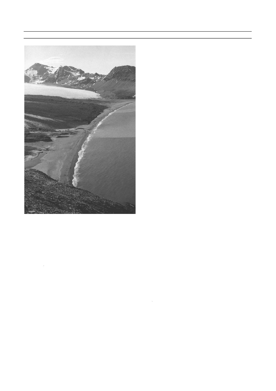
South Georgia lie the most extensive beaches of the Antarctic region.
Fed by numerous debris-laden glaciers and short glacifluvial streams,
substantial areas of the sheltered inner fjord heads have become infilled
by glacifluvial outwash plains fringed by extensive sand and gravel
beaches (Hansom and Kirk, 1989). The largest of these outwash
beaches occur at Salisbury Plain, Fortuna Bay, Cumberland Bay and
St. Andrews Bay (Figure A63) (Gordon and Hansom, 1986). Some of
the inner reaches of the fjords of South Georgia are affected by suffi-
ciently large quantities of floating ice calved from adjacent glaciers to
allow the development of intertidal boulder pavements similar to those
produced by sea ice further south (Hansom, 1983b).
Falkland Islands
The coastline of the Falkland Islands, like the islands themselves, is low,
flat, and reminiscent of the coastline of the Outer Hebrides of Scotland.
Although hundreds of smaller islands exist, the main island group com-
prises West and East Falkland separated by Falkland Sound. The intri-
cate and crenulate nature of the coastline is probably more related to the
submergence and faulting of the underlying Devonian, Carboniferous,
and Permian limestones and sandstones, rather than to the efficiency or
otherwise of marine erosion and deposition. In spite of the majority of
the coastline being rocky, steep and high cliffs are mainly absent except
in the extreme west where 100–200 m cliffs occur at Beaver Island.
Everywhere and especially within the broad embayments and inlets,
there are innumerable small islets and skerries whose detailed morphol-
ogy and outline appear to be structurally controlled. A notable feature
of the rocky coastline is the abundance of dense stands of giant kelp in
the nearshore. On the western flank of the fault that controls Falkland
Sound, narrow coast-parallel outcrops of hard and softer rock have
been eroded to produce an intricate series of small headlands composed
of more resistant rock separated by small arcuate bays cut into less
resistant beds. The result is an essentially linear coastline stretching the
entire length of Falkland Sound, broken by regular and uniform bays
where the outer rocks have been breached. The crenulate nature of the
coastline and extensive areas of nearshore shallow water means that a
wide range of sheltered locations exists for potential beach development.
Streams, although abundant and rarely dry, do not appear to contribute
significantly to beaches, since there is a lack of beach development
adjacent to the mouths of the creeks and streams entering tidal waters.
Beaches of sand and gravels tend to be located in either outer coast sites
where ocean waves gain access or within inlets where more open aspects
allow wind-generated local waves to produce beaches. The high propor-
tion of shell-sand of the beaches points to an important biological
input from nearshore shallow waters. Significant beach development on
the outer coast occurs at Bull Point, Lively Island, and at Bertha’s
Beach where sandy spits and tombolos connect small islets to mainland
East Falkland. Paloma Beach, Elephant Beach, and Concordia Beach
in the north of East Falkland are all examples of large open coast sandy
beaches where strong winds have resulted in blown sand spreads over
inland areas. In West Falkland, large beaches occur within the inlet of
Whitsand Bay. Unfortunately, as a result of indiscriminate mine-laying
during the Falklands War, several of the beaches of East Falkland are
now unsafe and access is restricted.
Bouvet, Gough, Tristan da Cunha, St. Helena and
Ascension
Bouvet Island (Figure A60) stands at the southern end of the mid-
Atlantic Ridge, the slopes of the central cone terminating on all sides in
precipitous cliffs that descend abruptly to sea level. Probably a complex
of volcanic cones, the island rises almost symmetrically to a flat ice-
covered dome 935 m high. The ice covers the eastern side of the island
where it reaches the sea in an ice cliff 122 m high. The north and west
sides are free of ice but are much steeper. Between 1955 and 1958, a new
0.2 km
2
rock platform emerged at 25 m above sea level as a result of
either eruption or rock falls associated with tremors (Stonehouse, 1972).
Since little low-level ground was previously to be found around the
coast of Bouvet, the new addition has become a prime-breeding site for
penguins, petrels, and seals. Gough Island (Figure A60) lies 2,300 km to
the east of the Cape of Good Hope, South Africa and is the eroded
summit of a Tertiary volcano. Although the island is mountainous, ris-
ing to 910 m above sea level, the slopes are cut by deep gullies or gulches
and the coastline is characterized by steep cliffs that appear to have
undergone erosion to produce a variety of narrow boulder beaches at
the foot of the cliffs. There are also numerous islets, stacks, and skerries
that mostly lie within 100 m of the coast. Tristan da Cunha lies 350 km
to the northwest of Gough. It is a circular island of 98 km
2
with four
other small islands close by. The base of the central volcanic peak lies
ATLANTIC OCEAN ISLANDS, COASTAL GEOMORPHOLOGY
91
Figure A63 Saint Andrews Bay, South Georgia, is fed by glacigenic
sediment and is characteristic of the extensive outwash beaches of
the north coast of the island.
3,700 m deep on the seabed and the summit rises to almost 2,100 m
above sea level. The lower slopes are almost entirely lava and form high
cliffs that surround the island. Emerged beaches, platforms, and caves
occur at 5 m above sea level on Tristan but 12 m above sea level on the
small adjacent islands, indicating differential tectonic uplift in the area
(Bird, 1985b). In some places, small and inaccessible beaches occur,
some of which are sandy. A small plateau at the foot of the main cliffs
on the northwest side at Herald Point provides the site for Edinburgh,
the only inhabited part of the island. The cliffs are lower along the
Edinburgh coast, allowing access to the sea via small gullies. A narrow
gravel beach has developed along this stretch of coast, fed by material
eroded from the cliffs. In the months following the 1961 eruption at Big
Point, on the updrift section of this coast, rapid recession of the cliff
was noted (10 m in 8 weeks). This contributed to accretion of the
downdrift gravel beaches which formed a spit enclosing a small lagoon
(Bird, 1985b).
St. Helena (Figure A60) is 122 km
2
in area and lies in mid-ocean,
2,900 km from Brazil and 1,900 km from the west coast of Africa. Like
Tristan and Gough, the coastline comprises high stepped and some-
times vertical cliffs cut by steep v-sided valleys. Emerged shore plat-
forms stand at 4–6 m above sea level (Bird, 1985b) and the numerous
offshore islets and skerries common on the south and west coast, such
as at Egg Island and Cockburn Battery, are almost absent from the
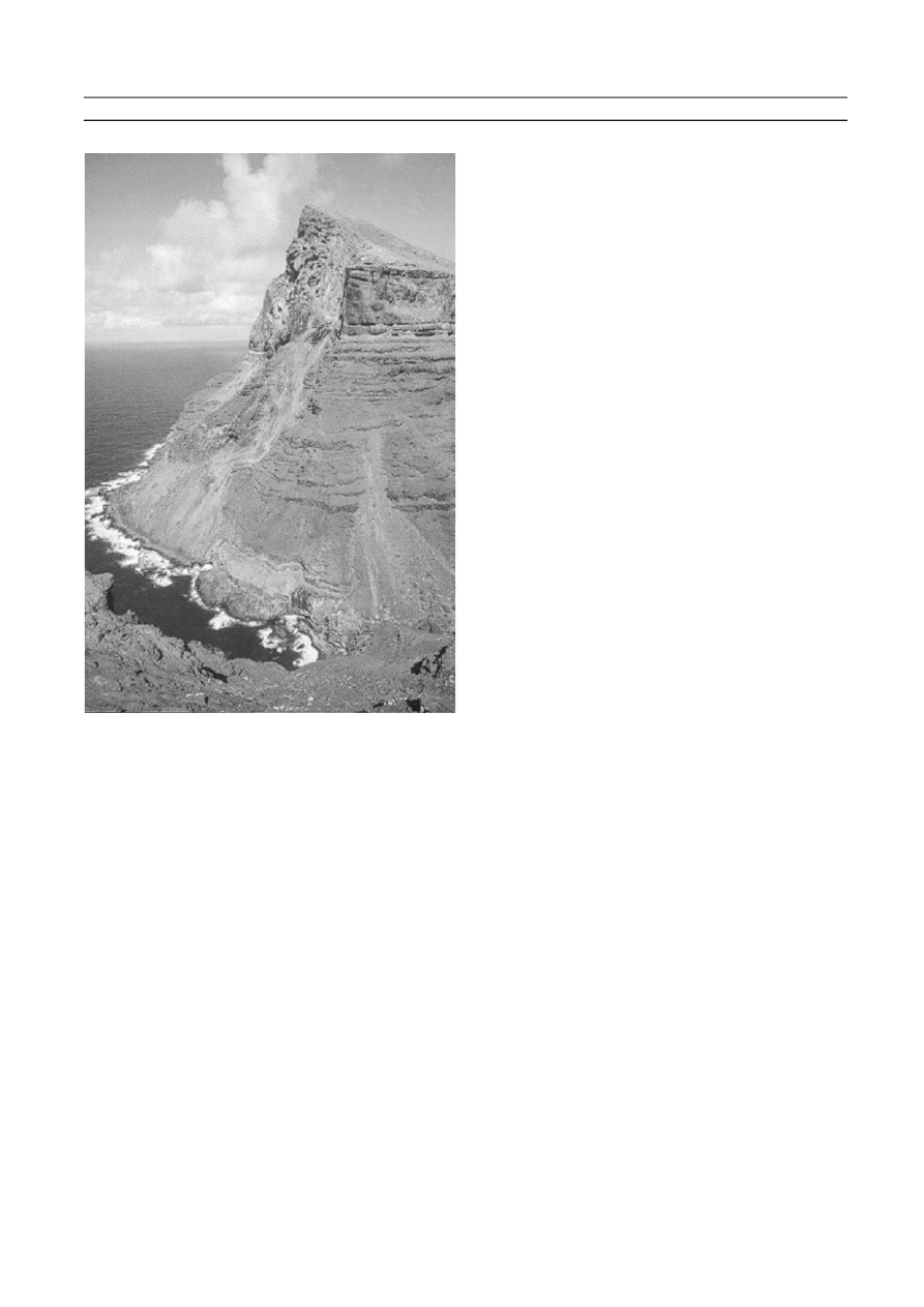
north and east coast. The highest cliffs occur at Flagstaff Bay in the north
and at Man and Horse Cliffs in the southwest where they reach 580 m.
The vertical steps in the coastal cliffs often correspond to differences in
the composition of the outcropping of lava flows. At Great Stone Top,
Turks Cap, and Prosperous Bay on the east coast, thick flows of tra-
chyte form vertical faces, which cascade debris onto stone chutes below
(Figure A64). Some of these extend into the sea to form fringing boul-
der beaches but nowhere on the outer coast are these well developed or
extensive. Only in favored locations where the deep gulches reach the
coast do small beaches, some of sand, occur, such as at Lemon Valley
Bay. At Sandy Cove on the south coast, the sandy beach is backed by
calcareous sand dunes. In mid-ocean some 1,300 km north of St. Helena
lies Ascension Island, a Holocene stratovolcano with no known historic
eruptions (Simkin and Siebert, 1994). Although more arid than
St. Helena, the coasts of both islands are similarly high and surrounded
by steep cliffs cut into volcanic lava. At Boatswain Bird islet, a natural
arch has been eroded into a 98 m high monolithic stack of trachyte
(Bird, 1985b). However, Ascension also has superb white sand beaches
derived from shell and coral. Outside of the Caribbean area, the
Atlantic Ocean is not noted for its corals although small structures are
known from the coast of western Africa (Trenhaile, 1997). Although
little seems to be known of the nature of the sediment supply to the
Ascension beaches, the carbonates can only come from shells and
coralline algae (such as Lithothamnion) growing in the narrow shallow
water fringing the island. Erosion of adjacent rock shores and terres-
trial sediment in-washed by infrequent rains probably account for the
remainder of the beach sediment.
Macronesia
The island groups comprising Macronesia stretch lie in a long line that
extends north between the coast of West Africa and the Portuguese
coast (Figure A60). All of the island groups are volcanic in origin and
many remain active volcanoes. Four main stratovolcanoes occur in the
arid Cape Verde Islands, Fogo, Brava, Santo Antao, and San Vicente.
Fogo is 2,829 m high yet only 24 km wide and so the steep seaward
slopes end abruptly in retreating cliffs. The volcano has erupted 10 times
between 1500 and 1995 each one sending long streams of lava down the
flanks into the ocean and altering the coastal geometry. A similar pic-
ture characterizes the other islands of the group, each being surrounded
by steep cliffs cut by deep gullies at the foot of which occur infrequent
gravelly beaches. Emerged features have been noted at six levels up to
100 m above sea level. Some bays contain fringing algal reefs and in
some locations boulders have been moved inland by wave activity by up
to 200 m (Bird, 1985b). The Canary Islands comprise seven main
islands, six of which host volcanoes. Some of these have erupted as
recently as 1971. The coastline of the Canaries resembles that of the
other mid-ocean volcanic islands in as much as the central volcanic
spine of the islands falls steeply to a mainly rocky and cliff coast cut by
deeply incised ravines. For example, in the northwest of Tenerife at
Acantilado de Los Gigantes, sub-vertical cliffs reach 500 m. The occur-
rence of such cliffs has constrained some of the tourist-related expan-
sion that many of the coastal towns and villages have undergone in
recent years. Some cliffs have been formed in sediments brought down
by torrents in the ravines. These deposits have since been tectonically
uplifted together with the boulder beaches that once fronted them. The
north coast of Gran Canaria has good examples of such cliffs, together
with well-developed shore platforms a few meters above sea level.
However, the volcanism of the Canaries has in places produced
several long and low craggy volcanic peninsulas that have allowed beach
development to occur. Fuertoventura, Lanzarote, Tenerife, and Gran
Canaria all have sandy beaches some with extensive sand dunes. The
long white sand beach at San Andres, on the southeast coast of
Tenerife, has been artificially nourished with sand brought from the
Sahara Desert. Between Maspalomas and Playa del Ingles, in the south
of Gran Canaria, 328 ha of fine shell sand have accumulated at the
mouth of the Fataga ravine to enclose a freshwater lagoon. On account
of the relative aridity, most dunes in the Canaries are sparsely vegetated
and the unfixed dunes at Maspalomas advance east towards the light-
house at a meter per year. Some of the dunes have succumbed to tourist
development, such as at Playa de las Canteras in the north of Gran
Canaria. In the easternmost part of the islands, the supply of beach sed-
iment from the nearshore and the inland ravines is augmented from a
more exotic source. Fuertoventura and Lanzarote are affected by the
summer scirrocco, a hot wind from the Sahara 90 km to the east, which
carries large quantities of dust and desert sand to the islands. Locally
known as the kalima, it turns the day into twilight and regularly covers
surfaces with a thin layer of sediment. Over the centuries, this sediment
has been an important source of sand for the beaches of the easternmost
islands. In the south, Fuertoventura narrows at the Pared isthmus where
sandy beaches extend eastward to connect the original island of Jandia
to the main island by what is now a low and narrow peninsula. On the
eastern shore, the sands of the 26 km-long Playa de Sotavento (Sp:
leeward) are protected from the dominant westerly waves. On the west-
ern side, the Playas of Cafete, Pared and Barlovento (Sp: windward) are
92
ATLANTIC OCEAN ISLANDS, COASTAL GEOMORPHOLOGY
Figure A64 The steep cliffs of Saint Helena are capped by
outcrops of trachyte at Great Stone Top on the south east coast.
(Photo courtesy of Barry Weaver.)
more exposed with strong currents and undertows. Nearby Lanzarote is
a similarly dramatic landscape of lava fields and steep cliffs with
intervening sand beaches, such as the sweeping Puerto del Carmen
beach on the east coast. Accretion is common at many of the valley-
mouth inlets.
Maderia comprises the main island itself, together with the smaller
island of Porto Santo, the nearby Islas Desertas, together with the
uninhabited Selvagens to the south. All of these islands are volcanic in
origin but have not been active in the last 1.5 million years. As a result
the, main volcanic core of Madeira, together with its plateau-like lateral
subsidiary vents, has become eroded to produce deeply incised valleys
and gorges running down to the sea. Between the mouths of the river
valleys are high cliffs of vertical columns of basalt with layers of red
and yellow tufa exposed in places. The 580 m plunging cliffs of Cabo
Giroa, west of Funchal, are among Europe’s highest, but high cliffs are
found everywhere on the coast of Madiera. In the north, fragments of
shore-platform occur as well as small islets and skerries, particularly
near Faial. There are several well-developed stacks near Ponta do Sao
Lourenco in the northeast. Small beaches of rounded gray basalt gravel
occur at several places, particularly where river mouths occur. The only
sandy beach is at Prainha, on the extreme east of the island where the
sand is mainly basalt. Shell sand occurs on the low plateau area in the
extreme east of the island. The nearby island of Porto Santo is 14 km
long and 5 km wide, its generally low volcanic profile veneered by thin
deposits of sand, calcareous sandstone and clay. The cliffs of the north
coast reach 100 m but the south coast is dominated by an 8 km long
white sand beach fronted by a shallow sandy-floored bay backed by low
cliffs of cemented sands. Protected from the main force of southwest-
erly storms by Madeira, from the west by the small island of Baixo and
from the north by its own cliffs, the south coast of Porto Santo is rela-
tively sheltered. It appears to have been subject to sediment accumula-
tion over a substantial period of time derived both from a combination
of shell sand from shallow nearshore surfaces, aeolian sand blown west
on the scirrocco from the Sahara to the east and from topsoil erosion
caused by early deforestation. The Selvagens are composed of limestone
capped by lava and ash and are cliffed to 100 m in the north but with a
gentler beach-fringed coast in the south. Emerged beaches and dune
calcarenites occur on Pleistocene marine terraces at 3 and 7 m above sea
level (Bird, 1985b).
The most northerly of the islands of Macronesia, the nine islands of
the Azores are a widely separated group of mountainous but fertile
islands which share the steep nature of many of the mid-oceanic islands
but also have long beaches and many fishing harbors. The coast of the
largest island, Sao Miguel, is a microcosm of the Azores coastline.
Where the coast is backed by higher volcanic peaks, it is characterized
by steep cliffs fronted by patchy low shore platforms, offshore stacks
and islets, such as at Mosteiros. Emerged beaches and platforms occur
at various heights up to 60 m (Bird, 1985b). However, the highly
indented coast also has short sandy beaches between cliff headlands.
Where the hinterland is lower, longer sand beaches occur such as at
Praia dos Moinhos and at Populo where small pine-clad sand dunes
occur. Several coastal features of note occur on the other islands. Pico
Island is 42 km long and dominated by a 2351 m cone-shaped strato-
volcano of the same name. Various historical lava flows have extended
the coastline and now have been eroded back to form low cliffs. In
places sheltered from the dominant westerly waves, smaller volcanic
forms survive on the coast, such as at Barca on the island of Graciosa
where a volcanic cone has been sectioned by marine erosion to form
bays fringed by crumbling cliffs of ash that cascade onto boulder
beaches below. The 1957/58 eruption at Capelhino on Faial showered
the adjacent coast in ash and contributed to accretion of the beach. At
Porto Pim, also on Faial, a substantial sandy spit has developed (Bird,
1985a). Such is the power of the surf reaching the Azores that Pico has
been chosen as the site of a pilot plant to produce energy from waves.
Faeroes and Jan Mayen
The rugged outer coast of the 16 main islands that comprise the Faeroes
is the result of the deep incision of past glaciers into a thick pile of hor-
izontally bedded flood basalts. These are slowly eroding, especially on
the west and north coasts, due to constant exposure to high-energy
westerly and northerly North Atlantic waves. The outer coast is
dominated by high and sub-vertical cliffs that reach 820 m at Hestmuli
in the north of the island of Kunoy. The rate of recession is unknown
but is higher on the seaward facing slopes where cliffs have developed
that tend to be steeper than immediately adjacent landward-facing
glaciated slopes, such as at Tindholmur in the extreme west. The slopes
of the inner coast are the sides of over-steepened glacial troughs that
have been flooded by Holocene sea-level rise and are more subdued and
better vegetated than the cliffs of the outer coast (Figure A65). Small
skerries, islets, and stacks (Fr: drangur) are common as are deep clefts
and geos (Fr: gjogvs) where dykes and faults have been differentially
eroded into the horizontal basalts of the west coast. Small, often struc-
turally controlled, ramped shore platforms are common around most of
the coast but tend to be more fragmented and smaller on the more
exposed west and south coast. More continuous and better-developed
platforms occur near the entrances to the fjords, particularly in the east.
For example, well-developed shore platforms occur on the east coast of
Vidoy. There are very few beaches in the Faeroes and the ones that do
occur are almost exclusively found at the sheltered fjord heads. In such
locations, wave approach is unidirectional and the limited amounts of
ATLANTIC OCEAN ISLANDS, COASTAL GEOMORPHOLOGY
93
Figure A65 Glacial troughs have been cut into horizontally bedded basalts and subsequently flooded by Holocene sea level rise to produce
cliffs that are characteristic of the inner coast of the Faeroese fjords. The plunging cliffs of the Faeorese outer coast are everywhere exposed
to high energy Atlantic waves.
sediment supplied by the small streams accumulates to produce small
pocket beaches composed of black basalt sand (such as at Tjornuvik,
Funningsfjordur, and Vidareidi) and occasionally backed by low sand
dunes (such as at Sandur and Saksun).
The coastline of Jan Mayen is dominated by the volcanic bulk of
Beerenberg, a 2,277 m stratovolcano that comprises the northern half
of the 54-km-long island (Norsk Polarinstitutt, 1959). The coastline of
Nord-Jan is steep and rugged, comprising 200–400-m-high cliffs eroded
in ash, lava and tephra as well as into the ice walls of tidewater glaciers
that spill down from the central crater. The coastline shows signs of
recent advance as a result of lava tongues from eruptions in 1970 and
1985, which have extended into the ocean. These recent eruptions and
flows are an extension of the mode of construction of the island over an
estimated 700,000 years. Such additions to the coastline have resulted in
the base of preexisting cliffs becoming buried by newer lavas and it is
onto this platform that more recent glacier terminal moraines have been
deposited, such as at Smithbreen in the northeast of the island
(Kinsman and Sheard, 1962). At Kroksletta, near the northern cape,
4,000-year-old moraines that rest on top of an emerged shore platform
and beach at 8–10 m above sea level have been buried by subsequent
lava flows. The protruding seaward edge of the Kroksletta lava is now
cliffed to a height of 5–13 m (Kinsman and Sheard, 1962). The south
part of Jan Mayen is a hilly ridge of scoria craters and mounds and
trachyte domes whose lower elevations and older age has produced a
coastline of low gradient rocky platforms connected by gravelly
beaches. In several places around the Sud-Jan coastline a prominent
rock platform is present upon which is sited emerged beach gravels. This
feature is particularly well developed on the north coast of Sud-Jan at
Sorbukta, Engelsbukta, and Haugenstranda. Sediment supply to the
central section coastline that joins Sud-Jan to Nord-Jan appears to be
healthy both from erosion of the lava cliffs to the west and from shallow
water sources: the 10 m depth contour lies about 0.7 km offshore. This
has resulted in the construction of a substantial barrier beach enclosing
a lagoon along an 11-km-long stretch of south-central coast at
Lagunevollen, with a smaller barrier and lagoon at Stasjonsbukta on the
north coast. The composition of these barrier beaches is not known but
assumed to be composed of mixed sands and gravels transported from
the west. Such a large beach complex is unusual for a small mid-oceanic
island. However, the full impact of Atlantic westerly waves and swell at
Sud-Jan is modified by a large circular submarine reef (probably an
eroded volcanic cone), which reaches to within 11 m of the sea surface
some 10 km south of Sud-Jan. Although the north coast is subject to
variable amounts of sea ice for an average of four months, the south coast
is mainly free of ice (Gloerson et al., 1992). Elsewhere, the coastline of
Sud-Jan is steep and rocky but the cliffs are not as high as in Nord-Jan
and small gravelly cliff-foot beaches fed by rockfall and wave erosion of
the adjacent lava occur.
Bermuda and Sable
With two notable exceptions, Bermuda and Sable, all of the Atlantic
Ocean Islands have, or have had, a close and recent association with tec-
tonic and volcanic activity. However, Bermuda, lying to the east of the
Carolinas coast of the United States is a group of 150 limestone islands
located about 1,000 km east of Cape Hatteras (Figure A60). The islands
rest on the southern margin of a 650 km
2
platform that is presently sub-
merged to depths of 20 m. However, boreholes at Bermuda have pene-
trated through a thin capping of calcarenites to meet lava at a variety of
depths of 171, 43, 33, and 21–24 m (King, 1972). The platform of vol-
canic rocks is the site for the northernmost coral reefs in the North
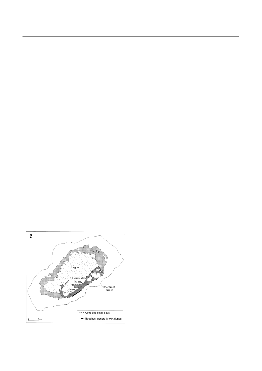
Atlantic. According to Vacher (1973) the present-day Bermuda plat-
form consists of four geomorphological-ecological provinces: a reef-
front terrace at 20 m depth; a main reef composed of 4 m deep
coral-algal reefs everywhere except in the south where algal inter-
growths occur; a 16 m deep lagoon in the north and the islands them-
selves forming a northeast trending chain near the southern edge of the
platform (Figure A66). The exposed limestones of the islands are
Pleistocene calcarenite, 90% of which is aoelian and the rest is beach
and shallow water in origin (Vacher, 1973). The aeolianites were built
from calcarenite produced mainly offshore and transported to the shore
and so the inference is that during an earlier phase of submergence,
the coastline was supplied by abundant reef-derived materials, which
then led to beach and dune development before becoming lithified.
This supply of reef-derived sediment to beaches and dunes continues
today and progradation appears to be healthy (Bird, 1985a), but patchy.
Nevertheless the present supply also appears to be more restricted than
the former supply, since only on the island’s south shore do extensive
beaches backed by dune occur. These extensive sandy beaches are pink
because of large numbers of fresh Homotrema clasts derived from the
reefs 1 km from the shoreline (Mackenzie et al., 1965). However, much
of the modern south coast is cliff with only limited sources of offshore-
derived sediment. Unlike during the earlier development of the cal-
carenites, the sediments of the lagoon now appear to play little part in
beach supply. As a result, the islands’ lagoon-facing shore is erosional
with a line of cliffs and few pocket beaches (Vacher, 1973).
Sable Island (Figure A60), on the continental shelf to the east of
Nova Scotia, Canada, is a low and wind-swept series of sandy islands
famous for its sandy shoals and shipwrecks. The development of the
Sable Island Bank, on which the islands sit, is related to the proximity of
the continental shelf-break and the maximum ice positions of the Late
Wisconsin and later readvances. These ice movements deposited a thick
suite of glacigenic tills and superficial sandy material, that was subse-
quently subject to transgression, modification, and transport (King,
2001). The island has spectacular but desolate sandy beaches backed by
sand dunes that reach up to 30 m high and cover 40% of the island’s sur-
face (Byrne and McCann, 1995). The intertidal zones of the long sandy
beaches are characterized by prominent shoreface attached ridges with
intervening depressions that reach up to 12 m deep (Dalrymple and
Hoogendoorm, 1997). Strong alongshore currents cause eastward
migration of these bars alongshore at rates of up to 50 m a
⫺1
and at
angles of up to 50
⬚ to the coastal orientation (Dalrymple and
Hoogendoorm, 1997). The dunes of Sable consist of primary dunes
that have developed in situ together with secondary dunes that have
migrated across the island. The resultant coastal morphology represents
a mix of both natural processes and anthropogenic disturbance. For
example, the constantly changing coastal outline has resulted in the relo-
cation of the lighthouse and is thought to be partly due to dune mobi-
lization and reduced vegetation cover under the enhanced grazing
pressure of introduced ponies (Owens and Bowen, 1977). Sable Island has
undergone 14.5 km of eastward migration but, in spite of this, its 30 km
2
has been maintained over the past 200 years (Cameron, 1965). Sable
Island thus seems to be subject to a regime of deposition that appears
roughly balanced by an equivalent amount of erosion.
J.D. Hansom
Bibliography
Baker, P.E., 1990. The South Sandwich Islands. In LeMasurier, W.E.,
and Thomson, J.W. (eds.), Volcanoes of the Antarctica Plate and
Southern Oceans. Washington, D.C.: American Geophysical Union,
pp. 361–395.
Bird, E.C.F., 1985a. Coastline Changes A Global Review. Chichester:
Wiley, p. 219.
Bird, E.C.F., 1985b. Atlantic Ocean Islands. In Bird, E.C.F., and
Schwartz, M.L. (eds.), The World’s Coastline. New York: Van
Nostrand, pp. 1035–1039.
94
ATLANTIC OCEAN ISLANDS, COASTAL GEOMORPHOLOGY
Figure A66 The calcarenite islands of Bermuda are sited atop a lava
plateau. The present coastline is mainly composed of low cliffs with
long beaches in the south (after Vacher, 1973).

Byrne, M.L., and McCann, S.B., 1995. Canadian Landform Examples-
31. The dunescapes of Sable Island. Canadian Geographer, 39(4):
363–368.
Cameron, H.L., 1965. The shifting sands of Sable Island. Geographical
Review, 44: 363–376.
Clapperton, C.M., 1971. Geomorphology of the Stromness Bay-
Cumberland Bay area, South Georgia. British Antarctic Survey
Reports, 70, p. 25.
Clapperton, C.M., Sugden, D.E., Birnie, R.V., Hansom, J.D., and
Thom, G., 1978. Glacier fluctuations in South Georgia and compar-
ison with other island groups in the Scotia Sea In Van Zinderen
Bakker, E.M., (ed)., Antarctic Glacial History and World
Palaeoenvironments, Rotterdam: A.A. Balkema, pp. 95–104.
Dalrymple, R.W., and Hoogendoorm, E.L., 1997. Erosion and deposi-
tion on migrating shoreface-attached ridges, Sable Island, Eastern
Canada. Geoscience Canada, 24(10): 25–36.
Gloerson, P., Campbell, W.J., Cavalieri, D.J., Comiso, J.C., Parkinson,
C.L., and Zwally, H.J., 1992. Arctic and Antarctic Sea Ice,
1978–1987. Satellite passive-microwave observations and analysis
(NASA SP-511). Washington, D.C.: Scientific and Technical
Information Program, NASA.
Gordon, J.E., and Hansom, J.D., 1986. Beach forms and changes asso-
ciated with retreating glacier ice, South Georgia, Geografiska
Annaler. series A, 68A(1–2): 15–24.
Hansom, J.D., 1981. Storm surging in South Georgia. British Antarctic
Survey Bulletin, 53: 141–146.
Hansom, J.D., 1983a. Shore platform development in the South
Shetland Islands Antarctic. Marine Geology, 53: 211–229.
Hansom, J.D., 1983b. Ice-formed intertidal boulder pavements in the
sub-Antarctic. Journal of Sedimentary petrology , 53(1): 0135–0145.
Hansom, J.D., and Gordon, J.E., 1998. Antarctic Environments and
Resources: a Geographical Perspective. Addison, Wesley, Longman,
p. 402.
Hansom, J.D., and Kirk, R.M., 1989. Ice in the intertidal zone: exam-
ples from Antarctica. Essener Geographische Arbeiten, Bd. 18:
211–236.
John, B.S., and Sugden, D.E., 1971. Raised marine features and phases
of glaciation in the South Shetland Islands. British Antarctic Survey
Bulletin, 24: 45–111.
King C.A.M., 1972, Beaches and Coasts. New York: St. Martins press.
King, E.L., 2001, A glacial origin for Sable Island: ice and sea-level fluc-
tuations from seismic stratigraphy on Sable Island Bank, Scotian
Shelf, offshore Nova Scotia. Geological Survey of Canada, Current
research. D19, 18.
Kinsman, D.J.J. and Sheard, J.W., 1962. The Glaciers of Jan Mayen.
Journal of Glaciology, 4: 439–448.
Mackenzie, F.T., Kulm, L.D., Cooley, R.L., and Barnhart, J.T., 1965,
Homtrema rubrum (Lamark), a sediment transport indicator.
Journal of Sedimentary petrology, 35: 265–272.
Norsk Polarinstitutt, 1959. Topografisk Kort over Jan Mayen. Blad 1 &
2, 1;50 000, Oslo.
Owens, E.H., and Bowen, A.T., 1977, Coastal environments of the mar-
itime provinces. Maritime Sediments, 13: 1–32.
Simkin, T. and Siebert, L., 1994. Volcanoes of the World. Tucson:
Geoscience Press.
Stonehouse, B., 1972. Animals of the Antarctic: The Ecology of the Far
South. London: Peter Lower/Eurobook.
Trenhaile, A.S., 1997. Coastal Dynanmics and Landforms. Oxford:
Clarendon Press.
Vacher, L., 1973, Coastal Dunes of Younger Bermuda. In Coates, D.R.
(ed.), Coastal Geomorphology. London: George Allen & Unwin, pp.
355–391.
Cross-references
Antarctica, Coastal Ecology and Geomorphology
Atlantic Ocean Islands, Coastal Ecology
Boulder Pavements
Cliffs, Erosion Rates
Cliffs, Lithology versus Erosion Rates
Glaciated Coasts
Scour and Burial of Objects in Shallow Water
Shore Platforms
Volcanic Coasts
Wave Power
ATOLLS
Atolls are coral reefs found in the open ocean consisting of an annular
rim surrounding a central lagoon. There is a general presumption that
atolls have volcanic foundations and some 425 have been recognized
around the world (Wiens, 1962; McLean and Woodroffe, 1994).
However, because of similar superficial morphology many shallower
water coral reefs have been termed “shelf atolls” (Ladd, 1977). In
Indonesian waters 55 such reefs have been recognized though many will
not have the volcanic foundations of the majority of atolls found in the
Pacific and Indian Oceans.
The largest atoll is Kwajalein in the Marshall Islands (120
⫻ 32 km
2
)
followed by Rangiroa in the Tuamotus (79
⫻ 34 km
2
), though many
smaller atolls are only a few kilometers in diameter. In a sample of
99 atolls, Stoddart (1965) indicated a mean area of 272.5 km
2
p
p
, and
atolls worldwide are considered to have a total area of 115,000 km
2
.
The contribution of atoll studies to marine geology
Ever since the historic scientific expedition of Charles Darwin in the
Beagle (1832–36) atolls have captured the imagination of marine geolo-
gists and Darwin’s synthesis of his ideas on the formation of coral reefs
(1842) have stimulated 160 years of research. This stimulus has come
from the facts that:
●
reef-building corals grow in shallow (
⬍100 m) water
●
many atolls rise from depths of several thousand meters
●
there is a similarity of morphology (annular rim and lagoon) wher-
ever atolls are formed.
Darwin’s hypothesis of atolls evolving from fringing reefs around a vol-
canic island via a barrier reef stage was the catalyst for subsequent
mainstream investigations into glacio-eustatic sea-level change, vertical
and horizontal tectonic movements, and the foundations and internal
structure of oceanic atolls. Atoll investigations have subsequently
played a major part in research into carbonate diagenesis, isostasy, con-
tinental drift, plate tectonics, and seafloor spreading. They have gener-
ally confirmed the remarkable insight of Darwin regarding the origin of
atolls.
The internal structure and origin of atolls
Darwin recognized that resolution of the problem of atoll development
required deep drilling and, after several aborted attempts, T. Edgeworth
David of Sydney University in 1896–98 drilled the atoll of Funafuti to
a depth of 339.7 m, all in shallow water coral, but so fragmented that
those who opposed subsidence argued that the core passed through a
detrital slope deposit. It was to be almost 50 years before drilling totally
penetrated the coral of an atoll to the basaltic basement at a depth of
more than 1,300 m on Enewetak atoll. Subsequent drilling, much of it
associated with atomic tests, at Enewetak and Bikini atolls but also at
Midway by the US Geological Survey, and at Muroroa and Fangataufa
in French Polynesia, by the French, confirmed both the volcanic foun-
dations of atolls and the depth of in situ coral far below the photic lim-
its of both modern coral growth and growth at glacially lowered sea
levels. Volcanic basement was determined at 1,283 and 1,408 m at
Enewetak, 415 and 438 m on Mururoa (though seismic results show
basalt as shallow as
⫺170 m, Guille et al., 1996), 153 and 503 m at
Midway and 270–400 m at Fangataufa. These figures are typical of
those from many other atolls, which have now been investigated by
drilling or seismic survey.
While shallow water corals have been recognized to depths greater
than 1,000 m, clearly confirming widespread subsidence, considerable
lithification, cementation, and diagenesis has taken place in the lower
sections of the atoll foundations, which have been determined as up to
30,000,000 years in age. Alteration of the carbonate rocks results from
fluctuations of more than 100 m in sea level with vertical migration of
phreatic water table favoring the transformation of the original arago-
nite of the biogenic structure to calcite. At depths greater than 500 m
cold permeating sea water dissolves both aragonite and calcite leaving
behind only low-Mg calcite. Dolomitization takes place within thick
aquifers of mixed fresh and saline waters and is common in the lowest
portions of the atoll foundations.
Like other reefs, atolls were most recently exposed during the last
glaciation when karstic processes prevailed on the atoll surface, as in
previous low sea-level phases, forming a clearly identifiable “solution
unconformity” beneath Holocene reef material which is commonly only
10–20 m thick. Karstic features, including the saucer-like shape of
ATOLLS
95
Wyszukiwarka
Podobne podstrony:
[dcpp][Bidemare][Sea Travels][Eng] Lutus Confessions of a Long Distance Sailor
[dcpp][Bidemare][Self][Water][Eng] Emergency Disinfection of Drinking Water
[dcpp][Bidemare][Crociera Guide][Pacifico][Eng] Cruising the Galapagos Islands
[dcpp][Bidemare][Crociera Guide][Mediterraneo][Eng] Sailing to Ithaca
[dcpp][Bidemare][Romanzi][P] Bach Salvataggio In Mare
[dcpp][Bidemare][Meteo][Appunti][P] Di Casola Manuale di meteorologia
[dcpp][Bidemare][Romanzi][P] Wilbur Smith Sulla Rotta Degli Squali
[dcpp][Bidemare][Patente][P] Domande E Risposte Esame Patente Nautica Senza Limiti
Blaine, John Rick Brant Science Adventure 14 The Pirates of Shan 1 0
[dcpp][Bidemare][Altro][Energia][Appunti][P] Ambiente Italia Manuale Autocostruzione Collettori Sol
[dcpp][Bidemare][Patente][Appunti][P] Manuale di Diritto della Navigazione
[dcpp][Bidemare][Romanzi][P] Melville Billy Budd, Marinaio
[dcpp][Bidemare][Romanzi][P] Bambarén Vela Bianca
[dcpp][Bidemare][Romanzi][P] Verne Gli ammutinati del Bounty
[dcpp][Bidemare][Romanzi][P] Hemingway Il Vecchio E Il Mare
[dcpp][Bidemare][Romanzi][P] Salgari I Pescatori Di Balene
więcej podobnych podstron