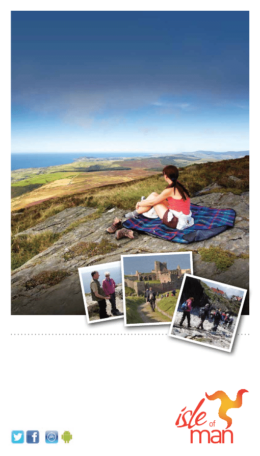
Isle of Man
Walking Guide
7 complete self-guided walks
www.visitisleofman.com/walking
isle of exploration
Sound
Cregneash
Calf of Man
PORT ERIN
PORT ST MARY
CASTLETOWN
Ballasalla
Colby
Santon
St Johns
Union Mills
Glen Vine
Crosby
Foxdale
St Marks
PEEL
Glen Maye
Dalby
Patrick
DOUGLAS
LAXEY
Baldrine
RAMSEY
Maughold
Snaefell
Andreas
Bride
Jurby
Kirk Michael
Ballaugh
Sulby
St Judes
Glen Mona
Greeba
Braaid
STRENUOUS - walks for experienced country walkers and a very good level
of fitness. The route will include some hills and rough country. Walking boots
and suitable clothing are essential.
3
MODERATE - walks for people with country walking experience and a good
level of fitness. The route will include some steep paths and open country.
Walking boots and suitable clothing are essential.
2
LEISURELY - walks for reasonably fit people with at least a little country walking
experience. The route will include un-surfaced rural paths and tracks. Walking
boots and suitable clothing are recommended.
1
Outdoor Leisure Map
It is recommended these walks are
used in conjunction with the Isle of
Man Outdoor Leisure Map. Each of
the maps displayed in this guide are
produced from that map and it can be
purchased from a number of outlets
on the Isle of Man including the
Welcome Centre at a cost of £7.00.
Please note these walk gradings are a general guide only. Bear in mind the distance of a walk, regional
differences and the possibility of inclement weather may make a walk more difficult than anticipated.
WALK GRADINGS
1
2
3
4
5
6
7
Loc
ati
ons
of
w
al
ks
fo
und
in
th
is
g
ui
de
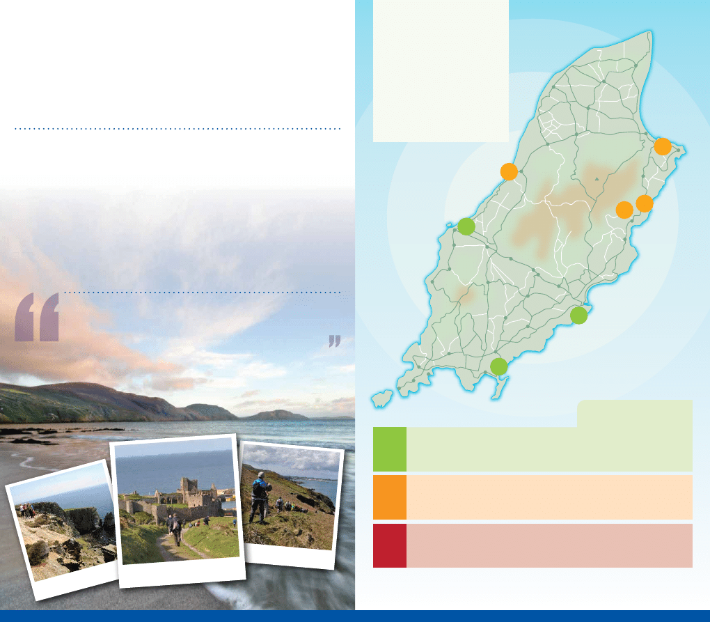
Go at your own pace
Within its modest shores, encircled by the wild Irish Sea, this Celtic gem
is home to a wealth of walks in a beautiful and diverse landscape. There’s
something to suit all ages and abilities, from gentle rambles on the level to
long distance footpaths with challenges for the seasoned walker.
The Isle of Man is a place I’d always wanted to visit – and when I did I fell in
love with it! With its sandy beaches, scenic harbours, spectacular rocky cliffs,
luscious green fields and a smattering of hills, it’s a walkers’ paradise.
- Andrew White, Walks Around Britain
The Chasms
Maughold Brooghs
Peel Hill and Peel Castle
The Manx countryside offers a visual feast in every season, so if you’re an all-weather
walker, any time of year is a good time to visit. The varied programme of the annual Isle
of Man Walking Festival is guaranteed to get you off on the right foot, while planning your
own walks couldn’t be simpler - start by taking inspiration from this guide.
Plentiful travel links with the UK and Ireland make the Isle of Man convenient for a short
break or more. Once you’re here, you’ll also find it easy to get around, whether or not you
have your own transport: bus links serve the whole Island and connect to the majority of
walking routes. In addition, our renowned heritage rail network allows you to combine a
day’s walking with unique vintage travel. Walking also offers an ideal way to explore the
Island’s fascinating heritage and abundance of wildlife.
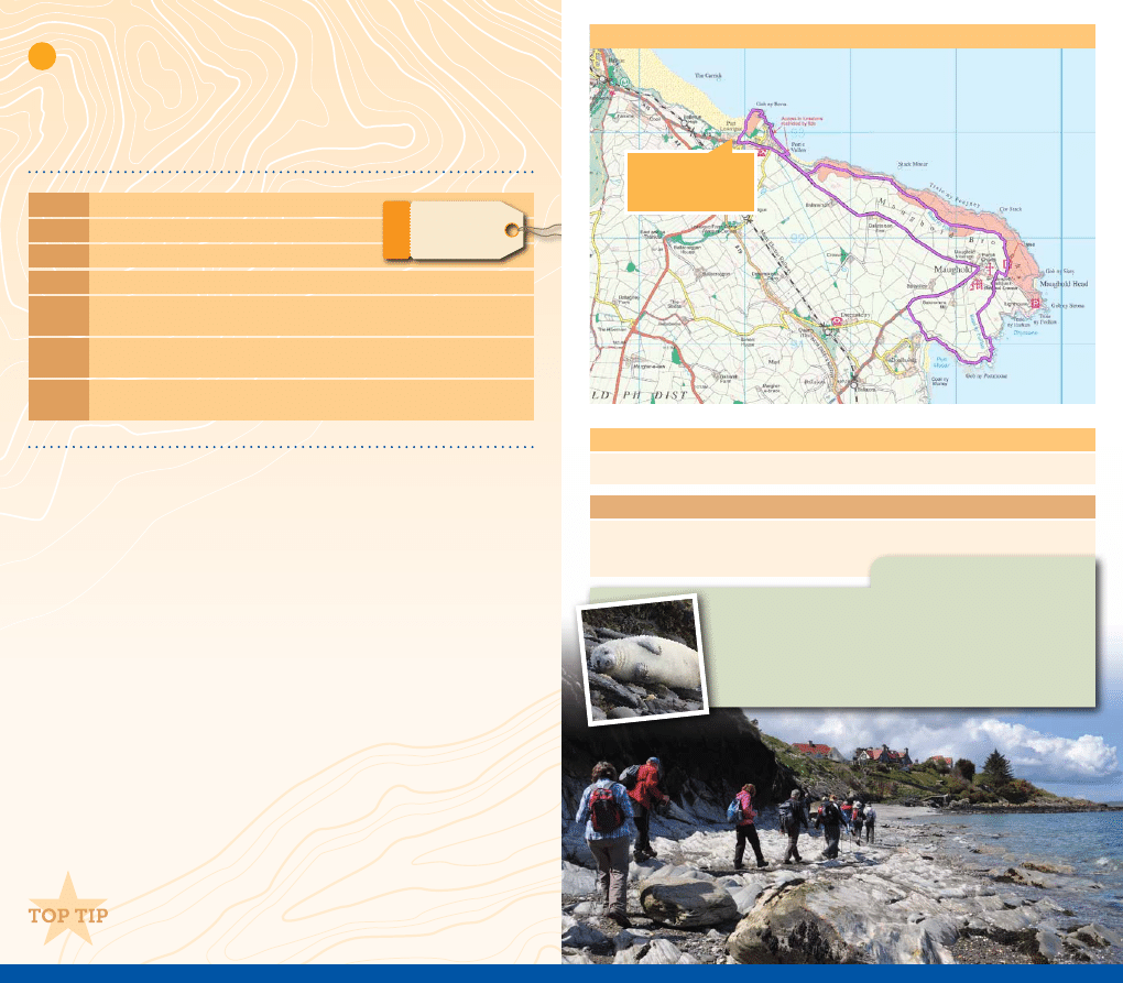
Take a short diversion to St Maughold’s Church in the village
to view the large collection of wonderful ancient crosses.
Grading: Moderate (very steep in places)
Distance: 4.5 miles
Start:
Port Lewaigue Car Park
Map Ref: 470 930
By Car:
Take the A2 from Douglas towards Ramsey and then Maughold road, parking
available by Maughold church and Booilushag.
By Rail: Take the electric tram north to Ramsey from Douglas or Laxey and alight at
Lewaigue or Belle Vue (request stop). Port Lewaigue is a short stroll down the hill.
By Bus: Services 3, 3A, 3B and X3 connect Douglas to Ramsey, services 16, 16A and 16B
connects Ramsey to Maughold.
Maughold, Port Mooar and Port e Vullen
This outstanding coastal walk in the north of the Island provides
spectacular views and the opportunity to spot plenty of wildlife,
returning via a quiet country lane through rolling farmland.
Route
1.
From Port Lewaigue head south, following the
Raad Ny Foillan footpath signs around the
Gob ny Rona headland and onto the beach at Port e Vullen.
2.
Please note that access to the foreshore is restricted at high tide. Walking on the road will
take you to the same point at Port e Vullen.
3.
Leave the shore via the slipway at Port e Vullen, turn left onto the quiet road.
4
.
After about 100 yards follow the
Raad Ny Foillan footpath sign on the left.
5.
You are now on Maughold Brooghs, heading towards Maughold Head lighthouse.
6.
After 1.5 miles you will reach a track on the left which leads down to St Maughold’s Well.
7.
The coastal footpath leads behind the St Maughold’s Church. If you wish to view the Celtic
and Manx crosses they are on display in the churchyard in the cross house to the right.
8.
Continue following the coastal footpath behind the church as it leads to the hidden cove
of Port Mooar.
9.
Follow the lane from Port Mooar to the quiet road and turn right back towards Maughold.
10.
Continue on this road, through the hamlet of Maughold and back to Port Lewaigue.
2
MODERATE
1
Facilities (subject to opening hours)
• Public Toilets are located outside the grounds of St Maughold’s Church.
Points of Interest (subject to opening hours and admission charges)
• The Island’s largest display of Celtic and Manx crosses are found at St Maughold’s Church.
• St Maughold’s Well (via a steep path).
Route Map
Maughold Brooghs is an excellent area for observing marine
and bird life. Many wild flowers grow here, including orchids.
Grey Seals can easily be spotted in the waters off Maughold
Head and around Port Mooar.
Nature - Watch
START / FINISH POINT
Port Lewaigue
Car Park
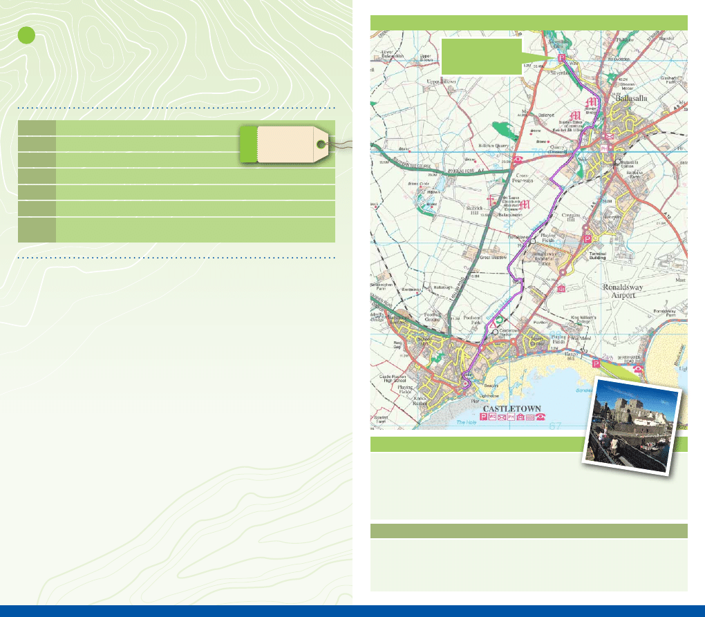
Silverdale Glen and Castletown
A glen and riverside walk taking you through some beautiful Manx
countryside. Allow yourself sufficient time to explore the historical
Rushen Abbey and Castletown, the ancient capital of Mann.
Route
1.
After exploring the delights of Silverdale Glen head towards Castletown with the river
on your left.
2.
There are a number of footpaths to choose from, all of which lead to the Monks’ Bridge
at Ballasalla.
3.
When you arrive at the Monks’ Bridge, do not cross it but continue along the river to the
ford and footbridge at Ballasalla.
4
. When you arrive at the footbridge turn right, away from the river, and walk along a lane
behind Rushen Abbey. (Should you wish to visit Rushen Abbey, continue to walk along the
river; you will find the entrance on your right.)
5.
After a few minutes you’ll reach the main road. Cross the road and turn right. Take the
footpath on your left immediately after the bend.
6.
Turn left at the farm and right shortly afterwards at the old ruins.
7.
You are now walking along the Silverburn River again. Continue along here to Castletown.
8.
The footpath finishes at the road bridge. Cross the road and continue to follow the river as
it enters Castletown harbour.
9.
Continue to follow the river, crossing the road at the next road bridge. Castletown is
immediately in front of you.
10.
Return by walking back along the river or by catching a bus or steam-train to Ballasalla
and then walking back to the car park at Silverdale Glen.
Grading: Leisurely
Distance: 2.6 miles (+ different return options)
Start:
Silverdale Glen Car Park
Map Ref: 275 712
By Car:
Take the A5 road from Douglas to Castletown. Park by Ballasalla Village Hall.
By Rail: Alight at Ballasalla Station, Rushen Abbey is signposted from the station.
By Bus: Services 1,1A,2,10, 11,11A,12 and 12A connect Douglas to Ballasalla. Services 8 and
8A connect Ballasalla with Port Erin, Foxdale and Peel (limited service).
1
LEISURELY
2
Facilities (subject to opening hours)
• Silverdale Glen - café
• Ballasalla - restaurants, public house and general store
• Castletown - numerous cafés, restaurants, public houses and shops
• Public Toilets are located at Ballasalla Station, Ballasalla Village Hall and Silverdale Glen
Points of Interest (subject to opening hours and admission charges)
• Silverdale Glen - Children’s Victorian Carousel
• Ballasalla - Monks’ Bridge, Rushen Abbey
• Castletown - Castle Rushen, Old House of Keys, Nautical Museum, Old Grammar School
Route Map
START / FINISH POINT
Silverdale Glen
Car Park
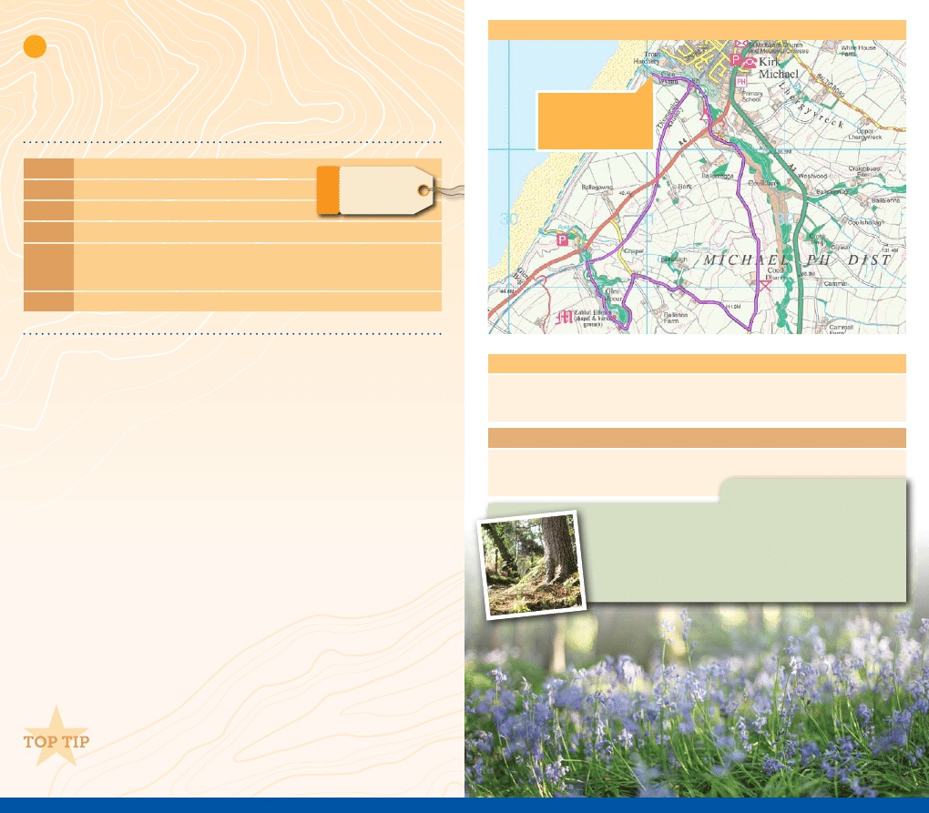
Glen Mooar and Glen Wyllin
Two beautiful glens, a disused Victorian railway line, an ancient site,
a nature reserve and one of the Island’s tallest waterfalls. What more
could you want from a short walk?
Grading: Moderate (steep and rocky in places)
Distance: 4 miles
Start:
Glen Wyllin Campsite Car Park
Map Ref: 312 905
By Car:
From Douglas, follow the A1 west to Ballacraine. Turn right at the traffic lights and take
the A3 to Kirk Michael. On entering the village, turn left along the A4 in the direction of
Peel. At the foot of the hill turn right and find parking close to the beach.
By Bus: Services 5,5A, 5C,6A and 6C from Douglas to Ramsey, stopping in Kirk Michael.
Route
1.
Walk past the camp site buildings and take the footpath on the right. A short climb up the
wooden steps takes you to the dismantled railway track.
2.
Continue along here for just under a mile, passing beneath two bridges.
3.
When you reach a lane, go straight ahead passing through a gate. This footpath
meanders down into Glen Mooar.
4.
Cross the footbridge and turn left. You are now walking up the glen towards the waterfall.
5.
At the top of the glen, turn left to visit Spooyt Vane, one of the Island’s tallest waterfalls.
6.
Return to the footpath and at the top of the glen go through the gate and over the footbridge.
7.
Turn left, pass the parking area and take the narrow road to the right. Continue along
here and up the hill for 0.5 miles.
8.
Turn left onto the by-way sign-posted Cooil Dharry. Continue along here for one mile.
Should you wish to visit the nature reserve you will pass the entrance after 0.8 miles.
9.
Shortly after the nature reserve you’ll walk past a few houses to reach the A4. The lane
taking you back to Glen Wyllin and your start/finish point is immediately in front of you.
Finish your walk with a short diversion into Kirk Michael
village where the cross slabs from Cabbal Pherick are on
display at the Parish Church.
2
MODERATE
3
Facilities (subject to opening hours)
• Kirk Michael - Post Office, Mitre Public House, Quayles Store, Glen Wyllin Campsite Store
• Public toilets are located at Glen Wyllin Campsite and Kirk Michael (main road)
Points of Interest (subject to opening hours and admission charges)
• Cabbal Pherick (St Patrick’s Chapel), an early Christian keeill
• Spooyt Vane waterfall
Route Map
Cooildarry Nature Reserve, owned by the Manx Wildlife Trust
makes for a lovely wooded riverside walk. In springtime, the
woodland floor is carpeted with primrose, wood anemone,
wood sorrel, lesser celandine and bluebell.
Nature - Watch
START / FINISH POINT
Glen Wyllin Campsite
Car Park
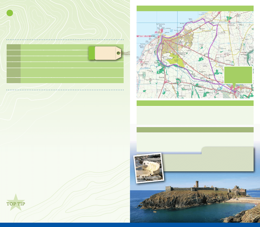
St John’s and Peel
A predominately flat walk using old railway lines which takes you
through rolling Manx countryside. A short coastal section takes you
to the city of Peel before returning along the Heritage Trail.
Route
1.
Take the Heritage Trail heading towards Peel. A little under 0.5 miles a bridge takes you
across the River Neb.
2.
Just after the bridge, take the steps and footpath on the right (next to a sub-station).
3.
After a hundred yards you will reach the A1. The footpath continues on the other side of
the road. Take care crossing as this is a fast section of the road. You now continue along
the old railway track for 1.8 miles.
4.
Leave the track at Ballagyr Lane and turn left.
5.
After a hundred yards, take the lane on the right which leads to the A4.
6.
Turn left and almost immediately take the footpath on the right, signed the
Raad Ny Foillan.
Continue along this coastal footpath for 1.5 miles into Peel.
7.
Walking alongside the harbour, past the Leece Museum heading towards the House of
Manannan, but do not cross the footbridge. You are now leaving the
Raad Ny Foillan.
8.
Continue past Peel Transport Museum and Moore’s Traditional Kipper Factory to find the
Heritage Trail directly in front of you.
9.
Keeping the River Neb on your right, continue along the trail for 3 miles back to St John’s.
Grading: Leisurely
Distance: 7 miles
Start:
Car park opposite St John’s school
Map Ref: 279 818
1
LEISURELY
By Car:
From Douglas, follow the A1 to St Johns. Parking found in the car park located close
to St John’s school.
By Bus: Services 4, 5,5A, 5C,6,6A and 6C from Douglas to St John’s.
Allow some time to explore the narrow streets and museums
of Peel. Sample some traditional Manx Ice Cream, or take a
stroll around the outside of Peel Castle to view the Grey Seals.
4
Facilities (subject to opening hours)
• St John’s - café and public house
• Peel - numerous cafés, restaurants and public houses
• Public toilets are available on the main road in St Johns and the seafront in Peel
Points of Interest (subject to opening hours and admission charges)
• St John’s - Tynwald Hill (the ancient site of the Manx parliament), Tynwald National Park
• Peel - House of Manannan, Leece Museum, Transport Museum, Moore’s Kipper House
• Heritage Steam Trail
Basking Sharks, Minke Whales and Grey Seals can all be
spotted around the Breakwater in Peel.
Nature - Watch
Route Map
START / FINISH POINT
St John’s Village
Car Park
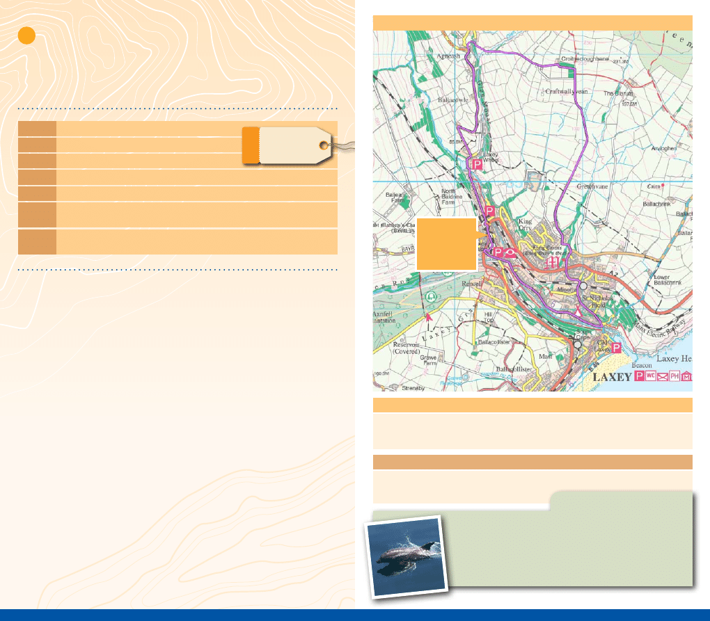
Laxey, Agneash and King Orry’s Grave
Magnificent views of Snaefell and surrounding hills, the historic
Great Laxey Wheel, the mythical King Orry’s Grave and the charming
village of Laxey all combined in one beautiful walk.
Route
1.
Cross the main road opposite the station and proceed up Ham and Egg Terrace, following
the signs to the Laxey Wheel. The wheel can be seen directly infront of you.
2.
Walk past the entrance to the wheel, continuing up the steep but very quiet road for just
under a mile to the hamlet of Agneash.
3.
Go straight ahead, past some small cottages on the right, taking the footpath running
alongside a garden and across a footbridge.
4.
Follow this footpath as it heads towards the ruins of a large house. Continue behind the
house and diagonally across a field, pass some old mine workings.
5.
Continue to follow the footpath and when it runs alongside a house, climb the few steps
up the bank heading towards a cottage and a plantation.
6.
Take the stile over the dry stone wall and turn right going through the wood. Turn right
again when you reach the footpath junction.
7.
The footpath then crosses the river as you head down towards Minorca. When you reach
a small housing estate turn right onto the road. King Orry’s Grave is just a short distance
along on both your left and right hand side.
8.
Cross the main road and continue down the hill to the harbour and beach.
9.
To return to the station, retrace your steps and take Glen Road, heading towards the Woollen
Mills where you can find a gallery and tearoom. After the Mills, take the lane to the right of
the bridge up to the former washing floors, the Snaefell Wheel and the Great Laxey Mines
Railway. Laxey Station can be found on the main road a short distance to the left.
Grading: Moderate (very steep in places)
Distance: 4 miles
Start:
Laxey Station
Map Ref: 433 845
By Car:
Take the A2 coast road between Douglas and Ramsey, parking available in the village.
By Rail: Manx Electric Railway from Douglas or Ramsey. Alight at Laxey or Minorca (request
stop) for King Orry’s Grave only.
By Bus: Services 3 and 3A from Douglas and Ramsey, or the less frequent service13 from
Douglas and Onchan.
2
MODERATE
5
Route Map
Facilities (subject to opening hours)
• Laxey - numerous public houses, restaurants and cafés
• Public toilets are located at Laxey Station and Laxey Promenade
Points of Interest (subject to opening hours and admission charges)
• Great Laxey Wheel, Snaefell Wheel and the Washing Floors, Great Laxey Mines Railway,
Laxey Woollen Mill, Snaefell Mountain Railway
Minke Whales may be spotted off the Island’s east coast in
the waters around Laxey Bay during the Autumn and Winter
months. You may also catch a Bottlenose Dolphin between
the months of October and March.
Nature - Watch
START /
FINISH POINT
Laxey Station
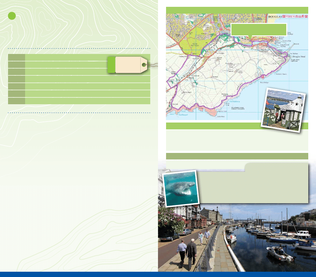
The ‘real’ Fairy Bridge and Marine Drive
This walk gives you a glimpse into how the Victorians spent their
holidays on the Isle of Man plus the (very important) opportunity to
greet the Little People.
Route
1.
From the steam railway station take the road across the harbour and turn right. Continue
along the main road for approximately 200 yards.
2.
When you reach the gates of The Nunnery, take the footpath which runs between Middle
River and the railway track through the grounds of The Nunnery.
3.
Continue along the edge of the golf course until you reach the main road again.
4.
Turn right. Cross the road just after the school and take the footpath on the left next to a farm.
5.
After just under 0.5 miles you will reach a ford and footbridge. Before you cross the river
take the hidden footpath on the right. This will take you to the real Fairy Bridge.
6.
Returning back to the track, cross the river and continue for about 400 yards and then
turn left along the tarmac track leading to the A25.
7.
Turn left, go over the railway bridge and then turn right.
8.
Continue along this quiet road for about 400 yards.
9.
Turn left at Keristal. You are now walking along Marine Drive.
10.
Continue along this very quiet road, which is partially closed to traffic, for approximately 3
miles as it hugs the coastline to Douglas.
11.
Shortly after passing through the stone gateway, the Great Camera Obscura is on the right.
Also on Douglas Head is a statue of Sir William Hillary, the founder of the RNLI.
12.
Meander down Douglas Head to Douglas Harbour and back to the steam railway station.
Grading: Leisurely
Distance: 6 miles
Start:
Douglas Steam Railway Station
Map Ref: 379 751
1
LEISURELY
By Car:
All major routes to Douglas. Day parking at Chester Street or Shaws Brow.
By Rail:
The Isle of Man Steam Railway Douglas terminus is located at the top of North Quay.
By Bus: All major bus routes serve Douglas the capital of the Isle of Man.
6
Facilities (subject to opening hours)
• General shopping on North Quay and surrounding areas
• Public toilets are located at Douglas Market Hall (corner of North Quay/Market Hill)
and at the steam railway station
Points of Interest (subject to opening hours and admission charges)
• Douglas Head - the Great Camera Obscura
Risso’s Dolphins and the awesome Basking Shark may be
spotted in the waters off Marine Drive during the Summer
months. Over Winter you may also spot Bottlenose Dolphins
and Minke Whales.
Nature - Watch
Route Map
START / FINISH POINT
Douglas Steam Railway Station
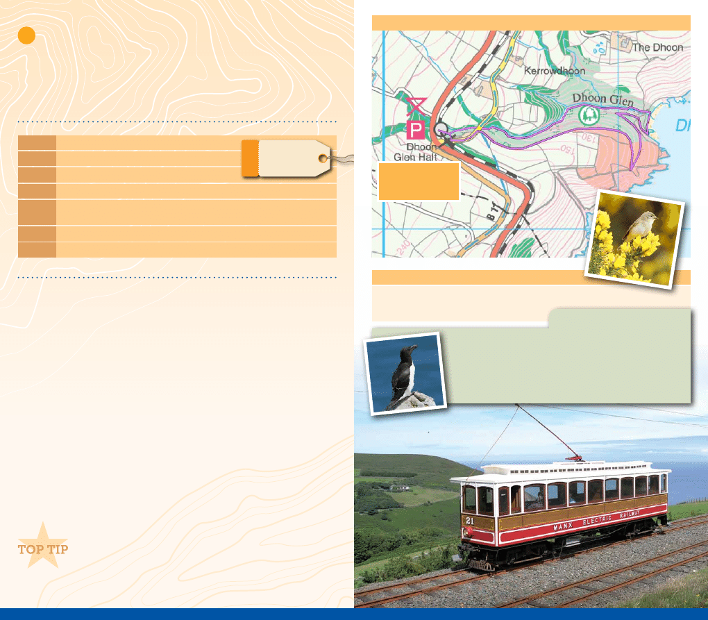
Combine this walk with a journey on the Manx Electric Railway,
visiting the attractions in Laxey or the range of independant
shops in Ramsey. Alternatively, explore another of the Island’s
Victorian Glens: Ballaglass Glen and Cornaa Beach are both just
a short tram journey to the North.
Grading: Moderate (a short but strenuous walk)
Distance: 2 miles
Start:
Dhoon Glen Halt on the Manx Electric Railway
Map Ref: 452 864
By Car:
Take the A2 Douglas to Ramsey Coast Road to the Dhoon. There is plenty of parking
to be found directly opposite the Dhoon Glen Halt and the glen’s entrance.
By Rail: Manx Electric Railway from Douglas, Laxey or Ramsey. Alight at Dhoon Glen Halt.
By Bus: Services 3 and 3A stop at the Dhoon Halt car park between Laxey and Ramsey.
Dhoon Glen
Dhoon Glen is one of the Island’s most dramatic glens and waterfalls,
nestling in a steep-sided valley, which leads to an isolated cove. The
return route takes you over the cliffs with stunning coastal views
before walking amongst the tree canopy and back to the car park.
Route
1.
Take care to cross the Manx Electric Railway tracks and enter the glen adjacent to the café.
2.
Turn left and take the path infront of the toilets that takes you down into the glen.
3.
Continue along the riverside walk through the glen until you reach Dhoon Bay.
4
.
Turn right, cross the stream (usually accessible without any problems).
5
.
Take the footpath at the cliff edge.
6.
Follow this track as it winds its way up to the headland.
7.
The path then turns inland. You are now walking above the glen.
8.
Just before you reach a lane, take the track on the right.
9
.
Following this track leads you back to the picnic area at the top of the glen.
2
MODERATE
7
Facilities (subject to opening hours)
• Café at Dhoon Glen
• Public toilets are located at the Dhoon Halt
Route Map
The sea cliffs that surround Dhoon Bay are home to chough,
peregrine and numerous seabirds. Keep a look-out too for
feral mountain goats at Bulgham and Minke Whales may also
be spotted off the coast in Autumn.
Nature - Watch
START / FINISH POINT
Dhoon Glen Halt
Car Park
Long Distance Walks
Raad Ny Foillan
The Raad Ny Foillan (Way of the Gull in Manx Gaelic) is approximately a 95 mile (153
kilometre) footpath hugging the Island’s coast. The route runs through beaches, roads,
fields and clifftops, affording lots of wildlife spotting opportunities and insights into
the Island’s heritage along the way. You can either choose to walk the whole footpath
in one go over a period of 5 or 7 days or complete small sections of the footpath at a
time, it’s entirely up to you.
Bayr ny Skeddan
The Bayr Ny Skeddan (‘The Herring Road’) runs 14 miles (22 kilometres) from Castletown
to Peel. It is so called because it was once the route taken by Manx fishermen between
the two key ports. For the first three miles, the route follows the Millennium Way, before
diverging after Silverdale Glen and ascending in the direction of South Barrule. At Glen
Maye, it joins the Raad Ny Foillan into Peel.
Millennium Way
The Millennium Way was established in 1979 to celebrate the Millennium year of
Tynwald. A distance of 28 miles (45 kilometres) it runs through the heart of the Island
from Sky Hill near Ramsey to Castletown, covering both roads and open moorland.
Heritage Trail
The Heritage Trail is a 10.5 mile (17 kilometre) walk from Douglas to Peel along the
former Isle of Man Railway company line. This gentle walk winds through scenic
countryside and is also popular with off-road cyclists
.
International Appalachian Trail
The International Appalachian Trail originated in the United States as an international
extension of the renowned US Appalachian Trail that extends from Georgia to Maine. The
goal is to establish a long distance walking trail that extends to all geographic regions
once connected by the Appalachian Mountains, of which the long distance footpath the
Raad Ny Foillan is a part.
Green Lanes
There are many miles of ancient ‘unmade roads’ in the Isle of Man. They are rights of
way through the countryside, not just for walkers but also for other users including
mountain bikes, horses and motorcycles. These roads are known as ‘green lanes’
but some are classified as ‘Greenway Roads’ on which vehicles are restricted. The
latest editions of the 1:25,000 Public Rights of Way and Outdoor Leisure Map or OS
Landranger 1:50,000 series will provide you with all of the information you need to
plan your perfect day out.
Go to www.visitisleofman.com/walking for more information
3
STRENUOUS

Wildlife Watching
Ayres Visitor Centre and Nature Trail
The Ayres National Nature Reserve, covering several miles of lichen heath, shingle beach and
sandy dunes, is famous for its wildlife, rare flora and nesting birds. The Ayres coastline is also a
great place to spot marine wildlife. The Visitor Centre is open May - September (free admission).
Scarlett Visitor Centre and Nature Trail
Just south of Castletown, Scarlett’s rugged limestone and volcanic rock formations are a great
place for rockpooling, fossil-hunting and birdwatching. The Visitor Centre, which tells you more
about the area’s geology and wildlife, is open May - September (free admission).
Nature Reserves
The Manx Wildlife Trust manages 22 local nature reserves, encompassing almost 300 acres of
land. Eight of the reserves are open to the public, which are places of tranquility, where you can
relax and enjoy the sights and sounds of nature. Go to
www.manxwt.org.uk
for more information.
Marine Wildlife
While a boat trip naturally offers the best chance of marine wildlife encounters, there
are plenty of good vantage points around the coast for sightings and permanent
binocular sites let you take a closer look:
Basking Sharks
Where:
All around the coastline but most commonly sighted along the west coast around
Peel breakwater and Niarbyl Bay.
When:
May - September.
Minke Whales
Where:
West coast (Summer), especially Niarbyl Bay; east coast (Autumn/Winter),
especially Marine Drive, Laxey Bay, Bulgham Bay.
When:
June - December.
Grey Seals
Where:
The Sound; Peel; The Ayres; Maughold Head; Langness.
When:
All year round.
Risso’s Dolphins
Where:
South-east coast from Douglas to The Sound.
When:
April - August.
Bottlenose Dolphins
Where:
East coast, especially Marine Drive and Douglas Bay.
When:
October - March.
Top ways to go walking in the Isle of Man
Wardens Walks
These self-guided walks are planned by the Forestry’s experienced and knowledgeable warden
around the Island’s plantations. They take in some of the Island’s best landscapes and vary in
difficulty, distance and terrain. The walks can be downloaded at
www.visitisleofman.com/walking
or purchased at the Welcome Centre, Sea Terminal.
Join the Festival
The Isle of Man Walking Festival is crammed with walks for all abilities
and interests. All walks are guided by knowledgeable walk leaders who
will accompany you through the Manx landscape, taking in the Island’s
wildlife and its dramatic past -
www.visitisleofman.com/walkingfestival
Ghostly goings on
The historic, winding streets of Douglas, Peel, Castletown and Ramsey
are alive with strange and chilling echoes from the past. Isle of Man Ghost
Tours bring to life ghoulish characters and incidents from Manx history and
myth. Go to
www.iomghosttours.com
for more information.
Spot some wildlife
Manx Wildlife Trust organise a series of guided walks during the year where you can explore parts
of the Island you might not have considered before, whilst spotting wildlife along the way. Go to
www.manxwt.org.uk
for more information.
Curator Walks
A series of guided walks ran by Manx National Heritage exploring ancient monuments, coast and
countryside in May to August. Go to
www.manxnationalheritage.im/whats-on
to find out more.
Get a guide
There are many qualified tour guides offering walks for all abilities that vary in length and location.
Go-Mann Adventures offer a number of guided walks led by Dr Andrew Foxon, Manx Registered Tour
Guide and qualified Walking Group Leader. Find out more at
www.facebook.com/GoMannAdventures
Activity Trails
Manx Activity Trails offer self-guided maps for driving, walking and kids days out, with a few fun
questions along the way! Go to
www.matsmaps.com
for more information.
Go Geocaching
This family friendly activity is a great way of seeing the outdoors. Why not
try finding one of the 25 caches hidden along the Millennium Way or the
one hidden at the Tower of Refuge in Douglas Bay, only accessible when
tide times permit! Go to
www.geocaching.com
for more information.
Glorious Glens
The Island’s 18 National Glens are jewels in the Island’s wild landscape. Whatever the weather the glens
offer a wonderful way to get away from it all and are a paradise for walkers, artists and nature lovers.
Endurance Events
The 85 mile Parish Walk is the Isle of Man’s ultimate road-walking endurance event whilst the End
2 End Walk takes participants from the Island’s most northerly point to it’s most southerly. Go to
www.visitisleofman.com/whatson
for more information.
Staying Safe
Coastal Safety Guidelines
• Keep to the path, away from cliff edges and overhangs
• Always supervise children, especially near cliff edges
• Wear or carry warm and waterproof clothing
• Cliff top walking can be dangerous in high winds
• Beware of taking shortcuts across beaches – you may be cut off by the tide
• The coastal path is for walkers, it is not suitable or safe for cycling or horse riding
We ask that you do…
• Keep to paths across farmland
• Close all gates unless it is obvious that they are intended to stay open
• Keep dogs under control
• Clear up your litter, particularly glass
We ask that you don’t…
• Disturb livestock
• Drop lighted cigarette ends
• Pick wild flowers
• Disturb birds’ nests
• Damage walls or fences
• Trespass on private property
• Foul pools or streams
• Damage crops
Castle Rushen
Great Laxey W
heel
Maughold Lighthouse
Getting Around
Bus & Rail
Bus Vannin offers a comprehensive public transport service around the Isle of Man. Individual
journey tickets are available from the bus driver. The Heritage Railway Transport System,
comprising the Manx Electric Railway, Steam Railway and the Snaefell Mountain Railway,
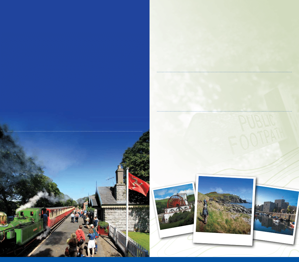
runs on a regular basis between the months of March and October. Many of the walks
featured in this guide tie in with the railways.
Multi-journey tickets are a great way to make the most of the Island’s transport network.
Saver tickets allow unlimited travel on scheduled bus services, while Explorer tickets include
all rail and bus services along with the Douglas Horse Trams. Heritage Explorer tickets
include all this plus free access to Manx National Heritage sites.
Get your tickets and timetables from the main bus and railway stations, and the Welcome
Centre. For more information visit www.iombusandrail.info.
Travelling with Dogs
The Isle of Man is full of great walks and locations that you and your dog can enjoy together
while visiting the Island. We ask that while you are on the Isle of Man you are respectful of the
countryside, keep your pet under control and on a leash through towns and villages. For more
information about travelling to the Island with your dog refer to www.visitisleofman.com/dogs
Eating Out
You’re never far away from somewhere good to eat in the Isle of Man; most of our recommended
walks tie in with cafés, pubs and restaurants. Pick up your free copy of the Taste Isle of Man
directory for a complete list of quality-assured eating out establishments. Available at the
Welcome Centre or go to www.visitisleofman.com/taste.

Key Contacts
Isle of Man Forestry Directorate – 01624 801263
Isle of Man Weather – 0900 6243 300
Isle of Man Welcome Centre – 01624 686766
(open Monday to Saturday year round)
Nobles Hospital, Douglas – 01624 650000
Ramsey Cottage Hospital – 01624 811811
Travel and Accommodation: www.visitisleofman.com
Bus and Rail: www.iombusandrail.info
Eating Out: www.visitisleofman.com/taste
Maps courtesy of Department of Infrastructure Mapping Service. © Crown Copyright, Department of Infrastructure, Isle of Man
Please note: While every effort has been made to include accurate and up-to-date information, the Department
of Economic Development does not accept responsibility for any errors or omissions. For up to date
information on bus and rail times go to www.iombusandrail.info.
Wyszukiwarka
Podobne podstrony:
Analysis of?ad Man Walking
Dead Man Walking By MandyLeigh87
[Mises org]Murphy,Robert Study Guide of Man, Economy, And State
Cartaphilus How 2 Meet Women The Shy Man s Guide To Relationships
Cartaphilus HOW 2 Meet Women The Shy Man s Guide to Relationships 2
guide camino aragones pl
Herbs for Sports Performance, Energy and Recovery Guide to Optimal Sports Nutrition
Meezan Banks Guide to Islamic Banking
400 man
NLP for Beginners An Idiot Proof Guide to Neuro Linguistic Programming
freespan spec guide
Eaton VP 33 76 Ball Guide Unit Drawing
Herbs to Relieve Headaches Keats Good Herb Guide
man ar900
50 Common Birds An Illistrated Guide to 50 of the Most Common North American Birds
Configuration Guide WAN Access(V100R006C00 02)
Przegląd układu tłokowo – korbowego silnika MAN B&W – L 2330 H
installation guide
więcej podobnych podstron