
21
H. Balzter (ed.), Environmental Change in Siberia: Earth Observation,
Field Studies and Modelling
, Advances in Global Change Research 40,
DOI 10.1007/978-90-481-8641-9_2, © Springer Science+Business Media B.V. 2010
Abstract
This paper presents an intercomparison of two burned area datasets, the
L3JRC daily global burned area dataset derived from SPOT-VEGETATION and
the FFID burned area dataset from MODIS. Burned area dynamics are presented
and the influence of climate on the fire regime is discussed. Feedbacks of the fire
dynamics to the climate system are evaluated. The Russian fire danger index is
presented and compared to satellite observations of fires.
Keywords
Climate • Fire • Temperature • Arctic oscillation • Remote sensing
2.1 The Fire Regime in Siberia
The circumpolar boreal forest covers approximately 1.37 billion hectares, or 9.2%
of the world’s land surface. Siberia is a hotspot for climate change. As a tempera-
ture controlled region it is particularly sensitive to even small increases in temperatures.
In addition to this heightened vulnerability, the observed warming trend is more
than twice as high as the global average, and climate model predictions show that
this faster regional warming is likely to continue. Annual temperature anomalies
H. Balzter (*), K. Tansey, and J. Kaduk
Department of Geography, Centre for Environmental Research, University of Leicester,
University Road, Leicester LE1 7RH, UK
e-mail: hb91@le.ac.uk; kjt7@le.ac.uk; j.kaduk@leicester.ac.uk
C. George, F. Gerard, and M.C. Gonzalez
Centre for Ecology and Hydrology, Maclean Building, Benson Lane, Crowmarsh Gifford,
Wallingford, Oxfordshire OX10 8BB, UK
e-mail: ctg@ceh.ac.uk; ffg@ceh.ac.uk; cuevasgonzalez@gmail.com
A. Sukhinin and E. Ponomarev
Siberian branch of Russian Academy of Sciences, VN Sukachev Institute of Forest,
Academgorogok, Krasnoyarsk 660036, Russia
e-mail: boss@ksc.krasn.ru; evg@ksc.krasn.ru
Chapter 2
Fire/Climate Interactions in Siberia
H. Balzter, K. Tansey, J. Kaduk, C. George, F. Gerard, M. Cuevas
Gonzalez, A. Sukhinin, and E. Ponomarev

22
H. Balzter et al.
since 1850 over central Siberia show a trend towards warmer temperatures at a
higher rate than the global average, and with a faster increase after 1990 (Balzter
et al.
).
The boreal forest is governed by fires, which generate a patchy mosaic of regen-
erating forest types. Lightning frequency, litter layer fuel mass and fuel moisture
content all impact on the fire regime and are linked to meteorological conditions.
Under scenarios of climate change many predictions show an acceleration of the fire
regime. Many fires are also human-induced. Both climate and human population
effects have been documented by Jupp et al.
). Greenhouse gas emissions
from fires are an important component in the global carbon cycle. Fire is arguably
the most important ecological disturbance worldwide releasing approximately
3.5 Pg C per year to the atmosphere (van der Werf et al.
). For the 1997/1998
carbon dioxide anomalies it is thought that 66% of the growth rate anomaly can be
attributed to global biomass burning, of which 10% originated from the global
boreal biome (van der Werf et al.
). It has been hypothesised that increasing
greenhouse gas emissions from an accelerating fire regime could lead to a positive
feedback with global warming (Amiro et al.
). Anticipated future climate
change in the Northern Hemisphere with an increasingly dry and hot summer
climate and an extended growing season could potentially lead to increased insect
infestations and increased susceptibility of boreal trees to fire (Ayres and
Lombardero
; Kobak et al.
).
Some authors have suggested that the fire regime in the boreal biome is coupled
to the climate system through large-scale atmospheric circulation patterns, e.g.
(Balzter et al.
; Hallett et al.
). Atmospheric oscillation patterns
have an impact on regional climatic variability and consequently vegetation activity.
Los et al.
) and Buermann et al. (
) found that two predominant
hemispheric-scale modes of covariability are related to teleconnections associated
with the El Niño Southern Oscillation (ENSO) and the Arctic Oscillation (AO):
The warm event ENSO signal is associated with warmer and greener conditions in
far East Asia, while the positive phase of the AO leads to enhanced warm and green
conditions over large regions in Asian Russia.
In the recent past Siberia has experienced extreme fire years (Sukhinin et al.
), which coincided with years in which the AO was in a more positive phase
(Balzter et al.
). Jupp et al.
) found that regional clusters of fire scars in
Siberia occurred in places with dry precipitation anomalies at scales of tens of
kilometers. An analysis of surface air temperature and precipitation at ten meteoro-
logical stations in West Siberia by Frey and Smith
) showed that West Siberia
shows increases in temperature and precipitation, particularly springtime warming
and more winter precipitation. Frey and Smith (
) found an association of
autumn and winter temperatures with the AO. On average, the AO was linearly
correlated with 96% (winter), 19% (spring), 0% (summer), 67% (autumn), and 53%
(annual) of the warming (Frey and Smith
The AO has shown a statistically significant trend towards the positive phase
between 1950 and the present day (Balzter et al.
), which is likely to indicate

23
2 Fire/Climate Interactions in Siberia
global climate change trends. Overland et al. (
) observed a shift in wind
fields from anomalous north-easterly flows in the 1980s to anomalous
south-westerly flows in the 1990s during March and April in Siberia, coinciding
with a systematic shift in the AO near the end of the 1980s. These hemi-
spheric-scale changes in the heat transport from the oceans to continental
parts of Siberia could have major repercussions for the fire regime (Balzter et al.
. The AO is also influenced by intense volcanic eruptions, which
inject aerosols into the stratosphere and via an enhanced temperature gradient
between the pole and the tropics lead to an acceleration of the polar vortex
(Stenchikov et al.
). This acceleration expresses itself as a positive phase
of the AO.
The following sections describe two remotely sensed burned area datasets,
followed by a discussion of the impacts of climate on fire, and the feedbacks of fire
on the climate system.
2.2 The L3JRC Global Daily Burned Area Dataset
Due to the extent and remoteness of Siberia the only cost effective way of monitoring
the fire regime is using remote sensing. A global daily burned area dataset at 1 km
spatial resolution is available from the VEGETATION sensor aboard the SPOT
satellite. A single algorithm was used to classify burnt areas from the spectral
reflectance data. SPOT 4 was launched in 1998 into a polar sun synchronous orbit
at 832 km. The algorithm is described in Tansey et al. (
), and is based primarily
on the 0.83
mm near-infrared (NIR) channel.
Burned forest area statistics were extracted by overlaying administrative regions
as vectors, reprojecting the L3JRC datasets to the Albers equal area projection and
calculating polygon statistics in the programming language R. Forest areas were
defined using the Global Land Cover 2000 map (Bartalev et al.
) as any of
the land cover classes “Evergreen Needle-leaf Forest” (class 1), “Deciduous
Broadleaf Forest” (3), “Needle-leaf/Broadleaf Forest” (4), “Mixed Forest” (5),
“Broadleaf/Needle-leaf Forest” (6), “Deciduous Needle-leaf Forest” (7), “Broadleaf
deciduous shrubs” (8), “Needle-leaf evergreen shrubs” (9), “Forest-Natural
Vegetation complexes” (21) or “Forest-Cropland complexes” (22). On the assump-
tion that the fire season is constrained by the winter time to be between Julian dates
161 and 272, any burned areas that were detected outside this date range were
masked out. This matches the date range used in generating the FFID burned area
dataset (next section). Table
gives the L3JRC burned forest area for each admin-
istrative region (oblast) obtained in this way. It shows that some oblasts have a
stable fire regime but in others a large interannual variability is observed. The stan-
dard deviation between years as a measure of interannual variability reveals that
Yakutia Republic, Evenk a.okr., Irkutsk oblast, Chita oblast, Buryat Republic,
Khabarovsk Kray, Amur oblast, Magadan oblast, Chukchi a.okr., Krasnoyarsk Kray

24
H. Balzter et al.
Table 2.1
Annual burned area statistics (km
2
) per oblast (administrative region) based on the
L3JRC global daily burned area dataset. Only forest areas (based on GLC2000) and Julian dates
161–272 were analysed
OBLAST
2000
2001
2002
2003
2004
2005
2006
Adigei Republic
27
54
6
27
8
25
51
Aga-Buryat a.okr.
64
19
3
327
121
15
54
Altai Kray
115
92
124
88
82
142
164
Amur oblast
2,493
869
2,632
3,708
1,841
1,333
5,048
Arkhangelsk oblast
4
4
9
2
5
9
3
Astrakhan oblast
0
0
0
1
3
0
9
Bashkortostan Republic
288
304
154
166
97
444
549
Belgorod oblast
112
58
65
47
47
57
181
Bryansk oblast
8
0
29
0
0
9
5
Buryat Republic
4404
1,656
1,235
7,695
2,771
2,964
4,918
Checheno-Ingush
Republic
0
0
0
0
0
0
0
Chelyabinsk oblast
22
111
23
82
85
108
63
Chita oblast
5,625
2,128
1,176
9,505
4,590
4,212
6,493
Chukchi a.okr.
995
986
1,587
3,025
1,829
488
2,752
Chuvash Republic
21
74
31
2
3
12
12
Daghestn Republic
0
0
0
0
0
0
4
Evenk a.okr
1,026
713
804
10,895
2,960
8,002
10,582
Gorno-Altai Republic
202
78
649
548
490
539
409
Irkutsk oblast
2,916
1,464
1,715
4,868
1,461
7,127
9,744
Ivanovo oblast
0
1
20
0
0
0
0
Kabardino-Balkarian
Republic
3
0
0
0
1
0
0
Kaliningrad oblast
0
0
13
2
0
0
1
Kalmyk-Khalm-Tangch
Republic
2
2
1
4
2
1
1
Kaluga oblast
0
1
29
0
0
0
0
Kamchatka oblast
686
50
153
153
398
245
77
Karachai-Cherkess
Republic
4
6
2
2
0
2
3
Karelia Republic
6
3
0
4
0
4
4
Kemerovo oblast
5
20
196
59
39
23
99
Khabarovsk Kray
6,469
2,344
4,232
6,130
4,482
6,171
4,740
Khakass Republic
12
15
38
49
27
73
60
Khanty-Mansi a.okr.
166
79
82
200
216
167
303
Kirov oblast
9
3
0
0
1
9
4
Komi Republic
216
214
211
33
96
73
60
Koryak a.okr.
940
761
311
1,085
343
331
529
Kostroma oblast
0
4
5
0
0
1
0
Krasnodar Kray
563
846
312
642
469
537
986
Krasnoyarsk Kray
999
660
539
2,495
1,988
949
1,528
Kurgan oblast
104
149
46
225
164
90
130
Kursk oblast
96
35
37
10
23
42
46
Leningrad oblast
0
0
4
0
2
0
24
Lipetsk oblast
95
159
93
54
146
235
135
(continued)

25
2 Fire/Climate Interactions in Siberia
Table 2.1
(continued)
OBLAST
2000
2001
2002
2003
2004
2005
2006
Magadan oblast
5,186
3,329
3,265
6,878
3,574
3,097
4,499
Mari-El Republic
0
1
1
0
0
0
0
Mordovian SSR
30
50
49
2
12
24
8
Moscow oblast
1
9
47
0
0
6
2
Murmansk oblast
7
59
65
164
93
58
22
Nenets a.okr.
9
13
38
13
17
14
20
Nizhni Novgorod oblast
14
47
110
15
8
34
13
North-Ossetian SSR
0
0
0
0
0
0
0
Novgorod oblast
0
0
0
1
0
0
0
Novosibirsk oblast
59
74
31
109
91
105
229
Omsk oblast
22
174
66
21
16
18
23
Orenburg oblast
63
133
116
79
98
219
185
Oryel oblast
91
108
44
15
36
79
15
Penza oblast
168
173
108
32
75
93
44
Perm oblast
12
69
10
22
10
50
14
Primorski Kray
1
16
6
253
41
50
57
Pskov oblast
0
0
19
1
0
0
1
Rostov oblast
215
319
315
220
394
296
324
Ryazan oblast
137
96
238
19
92
112
56
Sakhalin oblast
66
14
8
208
23
39
12
Samara oblast
159
328
309
149
123
319
184
Saratov oblast
208
318
184
198
313
429
312
Smolensk oblast
0
0
22
0
0
0
0
Stavropol Kray
86
212
66
123
119
155
315
Sverdlovsk oblast
19
55
76
143
86
374
28
Tambov oblast
181
316
241
113
238
348
251
Tatarstan Republic
484
431
554
172
158
282
201
Taymyr a.okr.
45
37
1
287
164
193
187
Tomsk oblast
42
152
395
110
689
66
225
Tula oblast
59
188
206
14
20
97
30
Tuva Republic
1,055
812
2,464
1,557
757
827
1,667
Tver oblast
2
2
47
0
0
1
1
Tyumen oblast
71
260
128
298
146
150
129
Udmurt Republic
3
2
0
0
21
2
0
Ulyanovsk oblast
243
291
146
73
56
173
117
Ust-Orda Buryat a.okr.
67
38
29
254
42
131
87
Vladimir oblast
0
2
21
0
5
0
0
Volgograd oblast
38
79
72
64
72
60
78
Vologda oblast
1
10
7
2
0
2
0
Voronezh oblast
287
334
214
187
272
214
274
Yakutia Republic
18,684
19,623
38,307
44,691
29,326
73,500
56,497
Yamalo-Nenets a.okr.
474
263
95
497
713
386
500
Yaroslavl oblast
1
2
22
1
0
0
0
Yevrey a.oblast
14
9
4
62
6
15
198
Russia
57,001
42,410
64,712
109,180 62,696
116,457 116,576

26
H. Balzter et al.
and Tuva Republic (in descending order) show the highest variability between
years, with standard deviations exceeding 500 km
2
year
−1
. Yakutia, the largest
oblast covering more than 3,100,000 km
2
of the ~17,000,000 km
2
of Russia, also
shows the highest mean burned forest area over the observed years.
2.3 Forest Fire Intensity Dynamics (FFID) Daily Burn Scar
Identification
Using moderate resolution sensors (approx. 1 km
2
pixels 2,000 km swath width) that
have a repeat time of 1 day or less in boreal regions, it is possible to determine
the date when a fire occurred during cloud-free conditions. This method was investi-
gated in the FFID project (Forest Fire Intensity Dynamics). For the FFID Daily
Burned Area product, instead of using thermal sensors for detecting active fires
which can then be missed due to cloud or smoke for example, a vegetation index
differencing approach is used which is able to discriminate disturbances long after
the event has occurred. The parameter used was the Normalised Difference Short-
Wave Infrared Index (NDSWIR), a combination of the near-infrared (NIR) and
short-wave infra-red (SWIR) signals, which is sensitive to vegetation water content,
and so can be used as a proxy for canopy density (George et al.
( 858 nm
1640 nm)
( 858 nm
1640 nm)
NDSWIR
r
r
r
r
−
=
+
(2.1)
The satellite data used was the Terra-MODIS Nadir BRDF-Adjusted Reflectance
(NBAR) 16-Day composite (MOD43B4) (Friedl et al.
), which has reduced
view angle effects that are present in wide view-angle sensors. The NBAR data
provide a nadir adjusted value of reflectance in each of seven bands once in every
16-day period. The removal of view angle effects and the adjustment to the mean
solar zenith angle (of the 16-day period) produce a stable, consistent product allowing
the spatial and temporal progression of phenological characteristics to be easily
detected (Schaaf et al.
). A MODIS data granule is 1,200 × 1,200 pixels, each
pixel being 927.4 m on a side.
At the northern reach of the boreal zone (approx. 70°N) the growing season is
very short so only the composites from mid July to mid September were included
to reduce any phenological effects. To keep the methodology consistent the same
period was used at the lower latitudes even though these areas had a much longer
growing season. The four composites within this time period were used to produce
the NDSWIR layers. For each of the four NDSWIR layers within a year, a NDSWIR
difference layer was calculated by subtracting that layer from the corresponding
layer from the previous year. This difference layer would then show a high value
where there was a large decrease in biomass, and a low value for those areas of
little change. The four difference images for each year were then combined to give

27
2 Fire/Climate Interactions in Siberia
one annual difference image (ADI). This annual difference greyscale image, ranged
from low values of no change to higher values showing missing biomass compared
with the previous year. To set the threshold to separate out burned areas, MODIS
thermal anomalies (TA) (Justice et al.
), which give the location and Julian
Day of active fires, were used. This assumed that if a TA were present, then that
ADI pixel had burned. Then for each of the IGBP woody land covers (classes 1–8)
within a granule, the mean ADI value under the TA’s were calculated, and this
value was used to set the threshold for that land cover class. The result is a binary
mask, with 1’s representing disturbance scars. However, this layer will also show
other disturbances apart from burning, such as insect infestations, wind blow or
logging. It also doesn’t show the date of burning. To identify and date any burns,
the TA’s are used again. Any scars not overlain with TA’s are discarded. For the
remaining scars, the pixels corresponding to the TA’s are assigned the Julian Day
of that TA. This leaves many of the burned areas being a combination of dated
pixels and undated pixels, the undated pixels being where perhaps there was too
much cloud or smoke for an active fire to be detected, but where there was still a
significant reduction in vegetation biomass. These undated pixels are then dated by
extrapolating from the dated pixels. The result is a raster with each burnt pixel having
a value of the Julian Day when it was burnt.
Table
shows the FFID burned area for each administrative region (oblast).
Table 2.2
Annual burned forest area statistics (km
2
) per oblast (administrative region) based on
the FFID dataset
OBLAST
2001
2002
2003
2004
2005
2006
Adigei Republic
0
0
0
0
0
0
Aga-Buryat a.okr.
473
58
3,452
298
243
205
Altai Kray
7,637
8,594
9,485
6,087
5,289
5,049
Amur oblast
13,278
20,096
33,445
5,972
9,817
20,172
Arkhangelsk oblast
530
274
173
292
189
317
Astrakhan oblast
0
0
0
0
0
0
Bashkortostan Republic
2,126
1,217
1,424
1,816
510
2,087
Belgorod oblast
1,189
1,124
96
120
373
408
Bryansk oblast
422
1,780
256
259
463
1,388
Buryat Republic
1,035
1,617
43,649
1,165
2,616
2,457
Checheno-Ingush
Republic
0
0
0
0
0
0
Chelyabinsk oblast
4,628
1,806
2,080
3,062
845
2,197
Chita oblast
4,947
5,436
78,097
5,226
5,031
11,432
Chukchi a.okr.
2,177
3,295
10,944
500
587
106
Chuvash Republic
142
75
24
80
148
342
Daghestn Republic
0
0
0
0
0
0
Evenk a.okr
80
623
167
102
964
6,731
Gorno-Altai Republic
275
190
309
129
16
30
Irkutsk oblast
3,837
6,756
26,583
2,578
3,080
13,194
Ivanovo oblast
40
559
32
28
60
681
(continued)

28
H. Balzter et al.
OBLAST
2001
2002
2003
2004
2005
2006
Kabardino-Balkarian
Republic
0
0
0
0
0
0
Kaliningrad oblast
88
299
329
281
192
561
Kalmyk-Khalm-Tangch
Republic
0
0
0
0
0
0
Kaluga oblast
30
1,392
156
103
109
1,549
Kamchatka oblast
1,730
574
556
83
117
181
Karachai-Cherkess
Republic
0
0
0
0
0
0
Karelia Republic
66
82
181
28
144
234
Kemerovo oblast
1,192
3,906
2,394
3,306
2,365
1,296
Khabarovsk Kray
6,423
7,375
16,696
3,020
11,260
4,086
Khakass Republic
588
1,671
594
992
1,225
390
Khanty-Mansi a.okr.
691
597
1,914
7,569
5,434
3,703
Kirov oblast
522
344
218
172
241
743
Komi Republic
941
68
57
242
127
97
Koryak a.okr.
1,294
1,276
3,759
200
287
390
Kostroma oblast
178
258
39
32
68
482
Krasnodar Kray
0
0
0
0
0
0
Krasnoyarsk Kray
3,925
6,859
10,013
7,868
7,336
11,214
Kurgan oblast
1,002
774
1,383
5,046
421
2,212
Kursk oblast
1,895
2,895
243
1,206
2,089
1,071
Leningrad oblast
68
1,397
183
277
303
2,143
Lipetsk oblast
1,866
2,002
378
1,361
2,106
1,018
Magadan oblast
6,248
1,993
9,871
762
365
564
Mari-El Republic
78
167
21
55
67
226
Mordovian SSR
681
729
187
464
528
1,283
Moscow oblast
83
2,339
237
208
101
1,755
Murmansk oblast
162
127
174
121
130
67
Nenets a.okr.
7
0
5
38
6
26
Nizhni Novgorod oblast
796
1,113
152
394
659
1,711
North-Ossetian SSR
0
0
0
0
0
0
Novgorod oblast
94
710
106
269
40
1,107
Novosibirsk oblast
9,184
8,082
6,641
9,180
7,415
16,584
Omsk oblast
5,436
3,237
2,568
7,551
1,777
6,784
Orenburg oblast
5,112
4,398
4,968
4,815
5,165
3,931
Oryel oblast
1,417
2,337
142
1,303
1,225
1,335
Penza oblast
1,701
1,434
532
1,023
1,052
2,812
Perm oblast
439
98
83
99
135
482
Primorski Kray
4,275
1,675
4,759
4,069
2,191
2,874
Pskov oblast
283
2,010
251
668
222
2,922
Rostov oblast
17
13
1
1
11
3
Ryazan oblast
775
1,929
261
876
1,188
2,142
Sakhalin oblast
208
540
1,169
102
68
100
(continued)
Table 2.2
(continued)

29
2 Fire/Climate Interactions in Siberia
OBLAST
2001
2002
2003
2004
2005
2006
Samara oblast
2,105
3,432
1,187
1,735
1,549
2,161
Saratov oblast
3,402
4,459
1,976
3,439
5,775
3,696
Smolensk oblast
206
3,652
966
559
58
3,916
Stavropol Kray
0
0
0
0
0
0
Sverdlovsk oblast
558
796
673
2,938
716
3,275
Tambov oblast
3,147
3,082
1,005
1,687
2,402
2,156
Tatarstan Republic
1,694
1,733
962
1,480
706
1,435
Taymyr a.okr.
68
29
28
43
39
176
Tomsk oblast
1,144
1,177
4,413
5,117
4,307
4,192
Tula oblast
791
1,515
163
851
1,005
1,814
Tuva Republic
1,184
8,383
1,771
221
736
532
Tver oblast
74
2,515
667
187
117
1,736
Tyumen oblast
1,194
638
2,288
7,676
741
5,560
Udmurt Republic
124
108
90
38
65
265
Ulyanovsk oblast
838
1,192
590
996
930
1,818
Ust-Orda Buryat a.okr.
186
708
3,010
39
482
836
Vladimir oblast
144
1,232
49
106
58
529
Volgograd oblast
2,713
2,403
905
1,553
2,822
1,398
Vologda oblast
173
581
99
54
116
532
Voronezh oblast
2,972
3,131
780
1,526
2,275
1,248
Yakutia Republic
36,534
58,789
22,535
1,875
11,259
3,793
Yamalo-Nenets a.okr.
539
1,015
774
1,145
3,717
3,067
Yaroslavl oblast
68
735
201
35
60
1,102
Yevrey a.oblast
2,769
1,945
3,193
3,847
3,510
1,878
Russia
164,940
221,451
329,761
128,643
129,841 191,992
Table 2.2
(continued)
2.4 Burned Forest Area Intercomparison
An intercomparison of the L3JRC and FFID datasets with other published burned
area data by Soja et al.
) and George et al.
) was carried out, the results
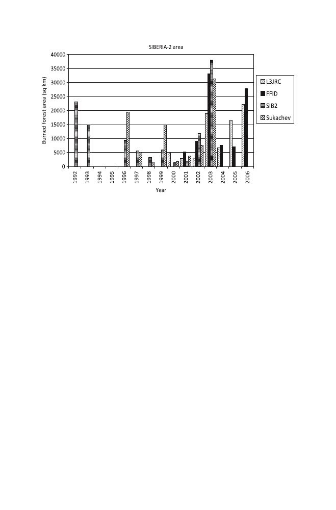
of which are shown in Fig.
. The study region “SIBERIA-2” is the same as in
George et al.
) since this was the largest common area coverage. The
SIBERIA-2 region covers over 3 million km
2
of Central Siberia, and includes
Irkutsk Oblast, Krasnoyarsk Kray, Taimyr, Khakass Republic, Buryat Republic and
Evenksky Autonomous Oblast (approximately 79–119
°E, 51–78°N). Figure 2.1
shows several catastrophic fire years in the Central Siberian region: 1992–1993,
2003 and 2006 showed large forest fires. When comparing the different datasets it
becomes apparent that while in most cases the interannual variability is similar, but
in particular years there are large uncertainties in the estimates.
30
H. Balzter et al.
2.5 Climate Impacts on Fire
Observations from remote sensing have shown that large-scale climate oscillations,
in particular the Arctic Oscillation, are thought to have an impact on forest fire
frequency in Central Siberia (Balzter et al.
). Climate data have
shown and climate models predict that the Arctic Oscillation responds to large-
scale volcanic eruptions such as the Mount Pinatubo eruption in 1991, which
injected large amounts of aerosols into the lower stratosphere and changed global
climate for several years (Stenchikov et al.
). Volcanic eruptions
can lead to a positive phase of the Arctic Oscillation (Stenchikov et al.
), which in turn provides conditions that are conducive to extreme forest fires
(Balzter et al.
Central Siberia contains several climatic and ecological zones. As a result many
authors have noted specific fire regimes influencing different forest types in the
region. The fire regime influences the duration of the fire season and the spatial
patterns of forest fires locations (Ivanova et al.
, Kurbatski and Ivanova
Valendick and Ivanova
). The degree of forest fine fuel to be ignited is deter-
mined by the variation of fuel moisture content, which is dependent on the length
of the dry period. Forest fire initiation and fire spread across the ground cover is
possible if the moisture content of fine fuels reaches a fixed low value after which
this parameter changes only slightly. In particular, for the needles of conifers
(except larch) the balanced moisture content is 11–26% depending on relative
Fig. 2.1
Intercomparison of annual burned forest area estimates from the datasets L3JRC, FFID,
L3JRC, SIBERIA-2, and SUKACHEV. The datasets cover different time ranges, only 2001–2003
is the common temporal coverage

31
2 Fire/Climate Interactions in Siberia
humidity, and for leaves of deciduous trees, needles of larch and grasses it is 9–31%
(Kurbatski et al. 1987).
Mass forest fire ignitions are caused mostly under the influence of atmospheric
anticyclones. The moisture content of fine fuels decreases to 9–30% and an extreme
fire danger state evolves after 85–150 h under these conditions without precipita-
tion. An uncontrollable situation develops if forest fires cannot be localized and
extinguished at an early stage.
Experimental data of the last 10 years show the interconnection between local fire
activity and local weather conditions forming at the same point in time. This inter-
connection is determined by a formation of stable anticyclones with lifetimes up
30–90 days over the region. Usually the process can be observed over regions
where mass forest fires burned at the same time. The exact physical processes have
not yet been described. However, it can be hypothesised that stable anticyclone
weather formations are influenced by convective heat flow from the epicentre of
active forest fires. This formed high-pressure zone ejects other cyclones and
cumulonimbus clouds.
The forest fire danger condition is characterized by the Russian fire danger
index (FD) that can be calculated using daily air temperature and dew point tempera-
ture measurements during the fire season. This index forecasts the degree of forest
fine fuel dryness and fire ignition ability indirectly. At the same time the value of
this index and the persistence of high values of the fire danger characterize not
only the forest fire danger state but also weather condition features formed by
fire convection flow.
According to experimental data, certain values of the FD index were identified by
Russian researchers for different stages of forest fire danger. An extreme fire danger
level in the forests of Central Siberia is present when FD reaches values of 3,000–
4,200. However, during last 10 years this index has been observed to be much higher
after long droughts. For example, the rain-free period in the Angara river forests in
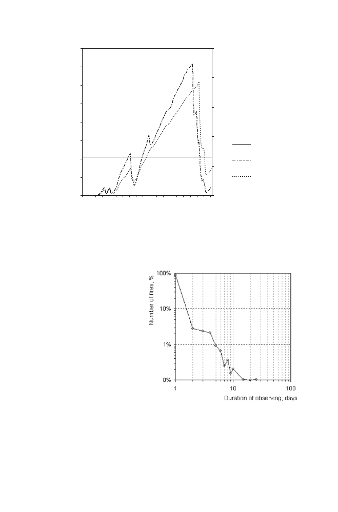
2006 was over 50 days (Fig.
). In Yakutia in the middle of the summer anticyclone
periods are dominating over 60 days annually. During these times the fire danger
index can be between 14,000 and 20,000. As Fig. 2.2 shows, the Russian fire
danger index is correlated with the Duff Moisture Code (DMC) of the Canadian
Forest Fire Weather System, although a slight temporal phase is noticeable.
Consequences of long droughts affect fire locating and extinguishing statistics.
Wildfires should be detected at the early stage of burning to enable efficient and
effective fire prevention measures. However, in a case of an extreme fire situation
non-localized fires are uncontrollable when fire fighting cannot extinguish them
efficiently anymore. Under these conditions forest fires can be active for about
30 days. In 2007 the percentage of fires that was located during the first day of
activity was about 88% (see Fig.
).
Figure 2.3 is illustrating the opportunity of forest fire prevention measures
according to material and technical support level. The annual part of large fires (area
more than 1,000 ha) that amount to not more than 5% of the total fire statistics but
up to 90% of the total damaged forest area – provides an objective appraisal for
the region.
32
H. Balzter et al.
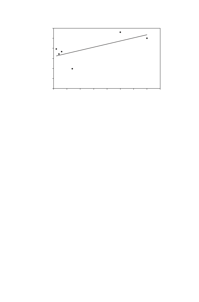
The FD index is effective at detecting conditions that enhance extreme fire activity.
The number of days on which the FD index exceeds 4,200 explains about half the
interannual variability in burned area in the Krasnoyarsk administrative region
determined from the FFID remotely sensed dataset (Fig.
Fig. 2.3
Frequency distribution
of the duration of active forest
fires in the Krasnoyarsk region,
2007. About 97% of the fires
burned only for 1–2 days, and
only 1% of fires burned for
longer than 5 days
Fig. 2.2
Extreme fire danger index dynamics in the Angara River region, from data recorded at
Kezhma meteostation for the fire danger season of 2006. The Canadian Duff Moisture Code
(DMC) is shown for comparison
16000
Russian FD index
Julian day
Canadian DM
C
FD
Extreme fire
danger value
DMC
14000
12000
10000
8000
6000
4000
2000
130
140
150
160
170
180
190
200
210
220
0
0
50
100
150
200
250
33
2 Fire/Climate Interactions in Siberia
Thus, weather conditions are determining the characteristics of the fire season in
Siberia. The frequency of prolonged droughts has been observed to increase. Mass
forest fire activity is influenced by extreme weather conditions forming at a
regional level.
2.6 Fire Feedbacks to the Climate System
Depending on the dominant processes, biosphere feedbacks to the climate system
can accelerate or slow down climate change (Cox et al.
). Fluxes of heat, water,
carbon, and other greenhouse gases between the land surface and the atmosphere
interact in complex nonlinear ways (Delworth and Manabe
). Siberian forest
fires feed back to the climate system by (i) emitting trace gases that contribute to
the greenhouse effect, (ii) emitting aerosols that reflect incoming solar radiation
back to space having a net cooling effect, (iii) disrupting carbon sequestration by
destroying vegetation that would otherwise take up carbon dioxide through photo-
synthesis, (iv) changing the heterotrophic respiration in the soil, (v) depositing char
and charcoal particles and dust on the ground that can be subject to infiltration into
the soil or erosion after rainfall and sedimentation downstream, (vi) changing the
water balance because of vegetation destruction leading to dryer conditions and
increased repeat fire risk in the fire scar, (vii) changing the albedo (proportion of
reflected incoming radiation).
Quantitative trace gas emission estimates from forest fires in Siberia are still
subject to considerable uncertainty. Soja et al. (
) estimate that from 1998 to
2002 direct carbon emissions during forest fires quantified by a mean standard
y=124.34x +6356.3
R
2
=0.4854
0
2000
4000
6000
8000
10000
12000
0
5
10
15
20
25
30
35
40
D ays w ith fire danger index > 4200
FFID burned area[km2]
Fig. 2.4
Regression analysis of remotely sensed burned area from the FFID project (km
2
) and the
number of days with a fire danger index exceeding 4,200 for the Krasnoyarsk region. Data points
represent the years 2001–2006

34
H. Balzter et al.
emission scenario amount to 555–1031 Tg CO
2
, 43–80 Tg CO, 2.4–4.5 Tg CH
4
and 4.6–8.6 Tg carbonaceous aerosols. These emissions represent between 10%
and 26% of the global emissions from forest and grassland fires (Soja et al.
A study of post-fire photosynthetic activity using MODIS fraction of absorbed
photosynthetically active radiation (fAPAR) data over Siberian burn scars found
that in the years immediately following a fire, fAPAR was reduced between 3%
and 27% compared to unburned control plots (
). The
amount of photosynthetic reduction depended on forest type and an interaction term
of forest type/latitude of the site.
Randerson et al.
) studied one particular boreal forest fire in Alaska and
quantified the effects of greenhouse gas emissions, aerosols, black carbon deposi-
tion on snow and sea ice, and post-fire changes in surface albedo on climate. The
net radiative forcing effect was a net warming of 34 Wm
−2
of burned area during
the first year, but a net cooling effect of −2.3 Wm
−2
over an 80 year period. The
reason for this is that long-term increases in surface albedo can have a larger radia-
tive forcing impact than greenhouse gas emissions from the fire (Randerson et al.
). However, whether these results are applicable to the entire boreal biome is
questionable.
2.7 Conclusions
Siberian forest fires are significant as a factor in the global carbon cycle because
of their large interannual variability. Climate impacts on the frequency and extent of
forest fires, and fires in turn feed back to the climate system via the atmosphere.
Current scenarios of global change indicate that we are likely to see changes in the
vegetation patterns and fire regime in Siberia. Satellite remote sensing has an
important role to play in monitoring the evolving fire regime from space.
Acknowledgments
The Global Land Cover 2000 database was generated by the European
Commission, Joint Research Centre, 2003, http://www-gem.jrc.it/glc2000.
References
Amiro BD, Stocks BJ, Alexander ME, Flannigan MD, Wotton BM (2001) Fire, climate change,
carbon and fuel management in the Canadian boreal forest. Int J Wildland Fire 10:405–413
Ayres MP, Lombardero MJ (2000) Assessing the consequences of global change for forest distur-
bance from herbivores and pathogens. Sci Total Environ 262:263–286
Balzter H, Gerard F, George C, Weedon G, Grey W, Combal B, Bartholome E, Bartalev S, Los S
(2007) Coupling of vegetation growing season anomalies and fire activity with hemispheric
and regional-scale climate patterns in central and east Siberia. J Climate 20:3713–3729
Balzter H, Gerard FF, George CT, Rowland CS, Jupp TE, McCallum I, Shvidenko A, Nilsson S,
Sukhinin A, Onuchin A, Schmullius C (2005) Impact of the Arctic Oscillation pattern on
interannual forest fire variability in Central Siberia. Geophys Res Lett 32:L14709

35
2 Fire/Climate Interactions in Siberia
Bartalev SA, Belward AS, Erchov DV, Isaev AS (2003) A new SPOT4-VEGETATION derived
land cover map of Northern Eurasia. Int J Remote Sens 24:1977–1982
Buermann W, Anderson B, Tucker CJ, Dickinson RE, Lucht W, Potter CS, Myneni RB (2003)
Interannual covariability in northern hemisphere air temperatures and greenness associated with
El Nino-Southern Oscillation and the Arctic Oscillation. J Geophys Res-Atmos 108:4396
Cox PM, Betts RA, Jones CD, Spall SA, Totterdell IJ (2000) Acceleration of global warming due
to carbon-cycle feedbacks in a coupled climate model. Nature 408:184–187
Cuevas-González M, Gerard F, Balzter H, Riaño D (2008) Studying the change in fAPAR
after forest fires in Siberia using MODIS, Int J Remote Sens, 29:23: 6873–6892. DOI:
10.1080/01431160802238427
Delworth T, Manabe S (1993) Climate variability and land-surface processes. Adv Water Resour
16:3–20
Frey KE, Smith LC (2003) Recent temperature and precipitation increases in West Siberia and
their association with the Arctic Oscillation. Polar Res 22:287–300
Friedl MA, McIver DK, Hodges JCF, Zhang XY, Muchoney D, Strahler AH, Woodcock CE,
Gopal S, Schneider A, Cooper A, Baccini A, Gao F, Schaaf C (2002) Global land cover map-
ping from MODIS: algorithms and early results. Remote Sens Environ 83:287–302
George C, Rowland C, Gerard F, Balzter H (2006) Retrospective mapping of burnt areas in
Central Siberia using a modification of the normalised difference water index. Remote Sens
Environ 104:346–359
Hallett DJ, Lepofsky DS, Mathewes RW, Lertzman KP (2003) 11000 years of fire history and
climate in the mountain hemlock rain forests of southwestern British Columbia based on sedi-
mentary charcoal. Can J Forest Res 33:292–312
Ivanova GA, Volosatova NA, Kukavskaya EA, McCrae DD, Conard SG (2005) Fire emission of
carbon in pines of Central Siberia. Remote sensing in forestry. Devises and techniques.
Institute for Forest, Krasnoyarsk, pp 51–54
Jupp TE, Taylor CM, Balzter H, George CT (2006) A statistical model linking Siberian forest fire
scars with early summer rainfall anomalies. Geophys Res Lett 33:L14701
Justice CO, Giglio L, Korontzi S, Owens J, Morisette JT, Roy D, Descloitres J, Alleaume S,
Petitcolin F, Kaufman Y (2002) The MODIS fire products. Remote Sens Environ
83:244–262
Kobak KI, Turchinovich IY, Kondrasheva NY, Schulze ED, Schulze W, Koch H, Vygodskaya NN
(1996) Vulnerability and adaptation of the larch forest in eastern Siberia to climate change.
Water Air Soil Pollut 92:119–127
Kurbatski NP, Ivanova GA (1987) Fire danger of pine forests of forest-steppe and its decreasing
technique. Institute for Forest, Krasnoyarsk, 112 p
Los SO, Collatz GJ, Bounoua L, Sellers PJ, Tucker CJ (2001) Global interannual variations in sea
surface temperature and land surface vegetation, air temperature, and precipitation. J Climate
14:1535–1549
Overland JE, Wang MY, Bond NA (2002) Recent temperature changes in the Western Arctic dur-
ing spring. J Climate 15:1702–1716
Randerson JT, Liu H, Flanner MG, Chambers SD, Jin Y, Hess PG, Pfister G, Mack MC, Treseder
KK, Welp LR, Chapin FS, Harden JW, Goulden ML, Lyons E, Neff JC, Schuur EAG, Zender
CS (2006) The impact of boreal forest fire on climate warming. Science 314:1130–1132
Schaaf CB, Gao F, Strahler AH, Lucht W, Li X, Tsang T, Strugnell NC, Zhang X, Jin Y, Muller J,
Lewis PE, Barnsley M, Hobson P, Disney M, Roberts G, Dunderdale M, Doll C, d’Entremont
RP, Hug B, Liang S, Privette JL, Roy D (2002) First operational BRDF, albedo nadir reflec-
tance products from MODIS. Remote Sens Environ 83:135–148
Soja AJ, Cofer WR, Shugart HH, Sukhinin AI, Stackhouse PW, McRae DJ, Conard SG (2004)
Estimating fire emissions and disparities in boreal Siberia (1998–2002). J Geophys Res-Atmos
109:D14S06
Stenchikov G, Robock A, Ramaswamy V, Schwarzkopf MD, Hamilton K, Ramachandran S
(2002) Arctic Oscillation response to the 1991 Mount Pinatubo eruption: Effects of volcanic
aerosols and ozone depletion. J Geophys Res-Atmos 107:4803

36
H. Balzter et al.
Stenchikov G, Hamilton K, Stouffer RJ, Robock A, Ramaswamy V, Santer B, Graf HF (2006)
Arctic Oscillation response to volcanic eruptions in the IPCC AR4 climate models. J Geophys
Res-Atmos 111:D18101
Sukhinin AI, French NHF, Kasischke ES, Hewson JH, Soja AJ, Csiszar IA, Hyer EJ, Loboda T,
Conrad SG, Romasko VI, Pavlichenko EA, Miskiv SI, Slinkina OA (2004) AVHRR-based
mapping of fires in Russia: new products for fire management and carbon cycle studies.
Remote Sens Environ 93:546–564
Tansey K, Grégoire J-M, Defourny P, Leigh R, Pekel J-F, van Bogaert E, Bartholomé E (2008)
A new, global, multi-annual (2000–2007) burnt area product at 1 km resolution. Geophys Res
Lett 35:L01401. doi:10.1029/2007GL031567
Valendick EN, Ivanova GA (2001) Fire regimes in forests of Siberia and Far East. Lesovedenie
4:69–76
van der Werf GR, Randerson JT, Collatz GJ, Giglio L, Kasibhatla PS, Arellano AF, Olsen SC,
Kasischke ES (2004) Continental-scale partitioning of fire emissions during the 1997 to 2001
El Nino/La Nina period. Science 303:73–76
Document Outline
Wyszukiwarka
Podobne podstrony:
05 Potential climate induced vegetation change in Siberia in the twenty first century
Harry Harrison Stars And Stripes 02 Stars And Stripes In Peril v3 0 (lit)
What is typical for call centre jobs Job characteristics, and service interactions in different call
Genome wide mapping of gene–microbiota interactions in susceptibility to autoimmune skin blistering
Simon Brown Keys of Power 02 Fire and Sword
SPACE CLIMATE MANIFESTATION IN EARTH PRICES
Water, air and fire at work in Hero’s machines
Elizabeth Lowell Mackenzie blackthorn 02 Fire & Rain
12 Lauren Dane Cherchez Clan 02 Fire and Rain
Celestial Fire Messianic Theophany in Zoroastrianism
Celestial Fire Messianic Theophany in Zoroastrianism
Cell surface in the interaction Nieznany
polar bears in warming climate
LotR The Hall of Fire Magazine 02
[WAŻNE] Minister Falah Bakir's letter to Wall Street Journal 'Don't forget Kurds' role in Iraq' (05
02 in bhp czyszczarka naroża okna pl
in lab 02
121127164610 bbc tews 100 irons in the fire
Audi? Codici Climatronic (Vw Audi Seat Skoda) In Italiano
więcej podobnych podstron