9
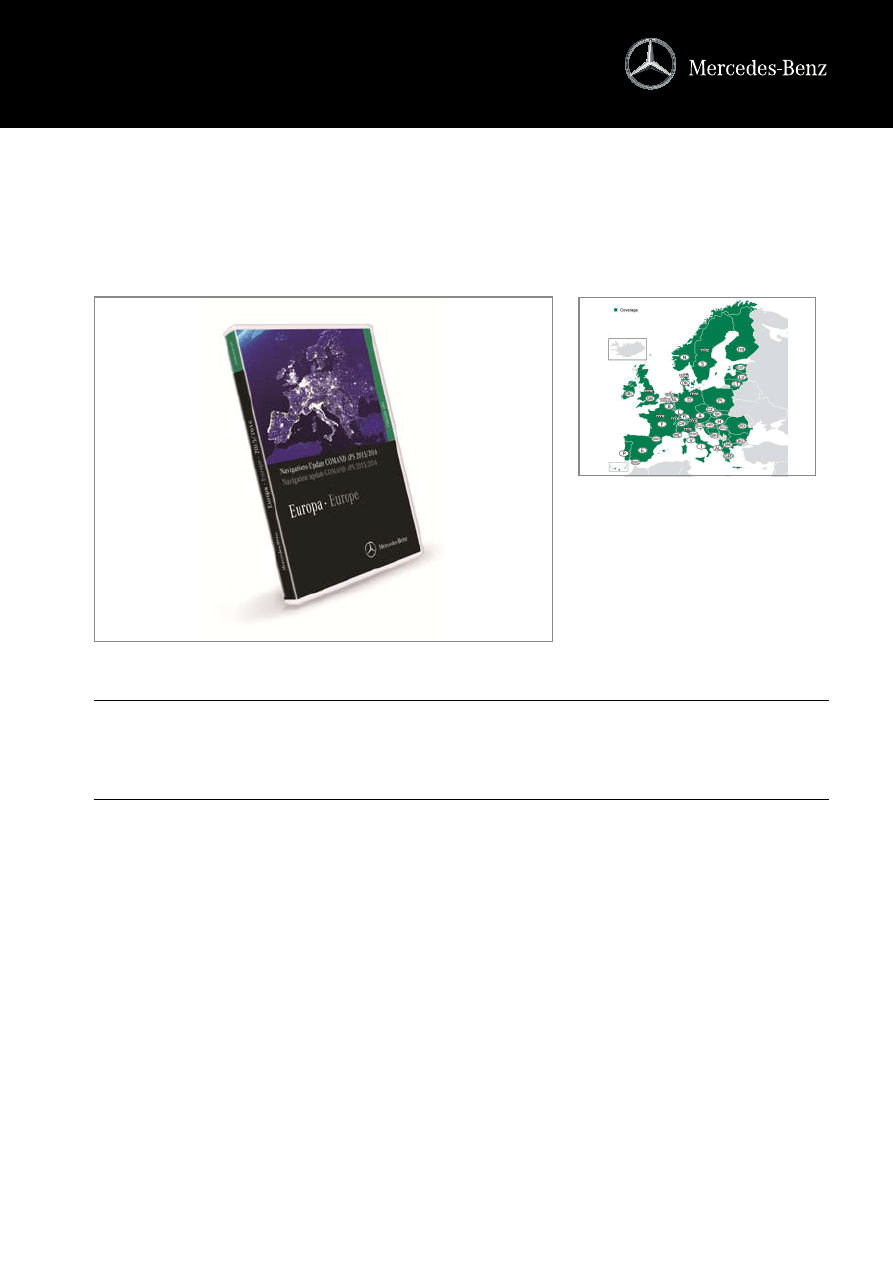
Navigation update, 'Europe', Version 2015/2016 for COMAND
APS (NTG1) - A211 827 0001
SupersedespreviousversionA2118274665
in BrieF
neWs
c
A new navigation update, designed to help your customers find their destination with the minimum of fuss, is now available. The new
update for COMAND APS (NTG1) ensures that your customers’ navigation system is up to the minute, with more countries and routes
than ever before.
c
Updated navigation data for the coManD aPs (nTG1) navigation unit.
c
The DVD is packed with navigation data for 38 european countries, with major and minor roads, towns, villages and plenty of
points of interest:
Albania, Andorra, Austria, Belgium, Bosnia-Herzegovina, Bulgaria, Croatia, the Czech Republic, Denmark, Estonia, Finland, France,
Germany, Gibraltar, Greece, Hungary, Ireland, Italy, Latvia, Liechtenstein, Lithuania, Luxembourg, Macedonia (FYROM), Monaco, the
Netherlands, Norway, Poland, Portugal, Romania, San Marino, Serbia, the Slovak Republic, Slovenia, Spain, Sweden, Switzerland, the
United Kingdom and Vatican City.
c
The 2015/2016 version covers the whole of Western europe.
The navigation data on the 2015/2016 version covers over 9.9 million kilometres of road throughout Europe.
c
in eastern europe there is full coverage of the Baltic states, Greece, croatia, Poland, the slovak republic, slovenia, the czech
republic, Hungary, Bulgaria and romania.
c
Prime coverage* has been significantly extended in the following countries:
• Bulgaria: +2 percent
• Slovenia: +1 percent
• Hungary: +5 percent
c
intensive work means that the quality of the maps for Bulgaria has been significantly increased (20,154 km Prime coverage*,
compared with 18,468 km in the previous version).
c
The 2015/2016 version features 90,789 towns and communities.
c
Precise navigation to the required house number expanded:
There is, for the most part, full house number coverage in central and northern European countries, while coverage has been improved
in the following countries:
• Lithuania: +7 percent
• Romania: +2 percent
Passengercars|May2015
Accessories·Telematics
Thedeliverydatesshownrepresentthelatestinformation.Thesedatesmaychangeonadailybasis.
Up-todateinformationcanbefoundinyourordersystem.
Telematics News

10
DeTaileD inForMaTion
PoinTs To noTe
orDerinG
c
Points of interest (Poi):
• Almost 2.5 million key points of interest are featured on the DVD, including filling stations, car parks, museums, restaurants and
hospitals. There are around 200,000 more POIs here than in the previous version.
• Some 3434 restaurants and 6755 nightlife destinations have been added to the new 2015/2016 version. If required, the naviga-
tion system will also show the user the quickest route to 2996 Mercedes-Benz service outlets.
Details can be found in the appendix to this issue of Telematics news.
c
Dynamic route guidance based on the latest traffic data (TMc/rDs):
Using the data from the Traffic Message Channel, the navigation system takes into account the latest motorway traffic bulletins and
automatically calculates diversions. This convenient service is available in 10 countries.
a list of the available countries can be found in the appendix to this issue of Telematics news.
c
road network updates:
• Map updates include millions of changes, e.g. new roads, crossroads, bypasses, junctions and motorway slip roads and exits. One
section of road may feature up to 260 attributes, such as the number of lanes or one-way routing. All of these attributes and the
vast number of points of interest have to be updated constantly.
• In this new version, for example, over 71,025 roundabouts, 202,802 turning restrictions, 48,755 one-way streets and 1,056,341
street names have been updated. In addition, over 1,906,460 kilometres of road have been updated, including approx. 1925 sec-
tions of motorway and dual carriageway.
Details for selected european countries can be found in the appendix to this issue of Telematics news.
c
Technical information:
• Package comprises: 1 DVD
• Please note the instructions supplied with the product.
• The multi-language menu navigation and directions depend on the system software, which forms part of this product.
c
compatibility colour code:
green
c
Please see oDUs for details of compatibility with the various model series and fitting restrictions.
order number
Description (Points to note)
available
A211 827 0001 Navigation update, COMAND APS, Europe, Version 2015/2016, green, NTG1
now
Navigation update, 'Europe', Version 2015/2016 for COMAND
APS (NTG1) - A211 827 0001
Passengercars|May2015
Accessories·Telematics
Thedeliverydatesshownrepresentthelatestinformation.Thesedatesmaychangeonadailybasis.
Up-todateinformationcanbefoundinyourordersystem.
Telematics News

18
Navigation update, 'Europe', Version 2015/2016 for COMAND
APS (NTG1) - A211 827 0001
DynaMic roUTe GUiDance:
roaD neTWork UPDaTes:
DeTails:
country
TMc tables
countries
roundabouts street
names
Turning re-
strictions
kilometres of
road
one-way
streets
Motorway sec-
tions
road signs
countries (38)
kilometres*
Total kilometres
coverage
Pois
House numbers
TMc
Belgium
Tritel 2.8
Denmark
DRD 11.1
Germany
BAST 13.0
France
Sétra 10.1
United Kingdom
ITIS 5.2
Italy
Infoblu 3.1
Netherlands
RWS 9.2
Austria
ASFiNAG 3.0
Sweden
SRA 2.5
Switzerland
ASTRA 6.3
Benelux
4818
33,328
6012
90,500
2520
145
8008
Germany
1934
112,921
32,299
100,866
2171
203
16,648
Finland
686
29,351
2706
72,543
587
15
7730
France
18,778
451,577
19,587
561,511
10,846
229
33,647
United Kingdom
6129
46,446
9932
112,983
3523
52
7913
Italy
7712
74,437
19,115
168,171
7625
281
7327
Norway
1734
13,939
1201
53,537
378
13
1645
Austria
171
27,768
3202
14,607
244
20
2436
Poland
1383
74,472
10,691
151,943
3626
182
10,483
Sweden
1459
17,428
1626
97,637
716
44
3088
Switzerland
385
26,631
910
11,733
189
31
300
Spain
25,836
148,043
95,521
470,429
16,330
710
15,011
Albania
Prime: 841 km
Complete: 26,066 km
26,907 km
Prime: 3%
Complete: 97%
7728
0%
Benelux
Prime: 291,174 km
291,174 km
(+3591 km)
Prime: 100%
153,512
(+166)
100%
B, NL
Bosnia-Herze-
govina
Prime: 8642 km
Complete: 47,891 km
56,533 km
Prime: 15%
Complete: 85%
7299
18%
Bulgaria
Prime: 20,154 km
Complete: 81,180 km
101,334 km
(+1467 km)
Prime: 20%
Complete: 80%
30,326
(+1687)
70%
Denmark
Prime: 127,896 km
127,896 km
(+1623 km)
Prime: 100%
40,059
(+664)
100%
X
Germany
Prime: 1,131,335 km
1,131,335 km
(+12,447 km)
Prime: 100%
335,693
(-3297)
100%
X
Estonia
Prime: 4909 km
Complete: 77,120 km
82,029 km
(+372 km)
Prime: 6%
Complete: 94%
10,098
(+75)
100%
Finland
Prime: 616,176 km
616,176 km
(+542 km)
Prime: 100%
45,612
(+2058)
100%
France (incl.
Andorra,
Monaco)
Prime: 1,496,986 km
1,496,986 km
(+22,734 km)
Prime: 100%
331,099
(-1729)
100%
F
Greece
Prime: 115,172 km
Complete: 255,386 km
370,558 km
(+11,951 km)
Prime: 31%
Complete: 69%
70,863
(-1207)
79%
United Kingdom Prime: 511,558 km
511,558 km
(+4856 km)
Prime: 100%
345,678
(-3744)
100%
X
Italy (incl.
Vatican City,
San Marino)
Prime: 767,199 km
767,199 km
(+9811 km)
Prime: 100%
208,987
(+1021)
87%
(+12%)
I
Croatia
Prime: 44,670 km
Complete: 38,975 km
83,645 km
(+659 km)
Prime: 53%
Complete: 47%
25,644
(+1389)
99%
Latvia
Prime: 7516 km
Complete: 94,504 km
102,020 km
(+491 km)
Prime: 7%
Complete: 93%
9612
(+49)
100%
Lithuania
Prime: 6690 km
Complete: 78,768 km
85,458 km
(+124 km)
Prime: 8%
Complete: 92%
8849
(+83)
75%
(+7%)

19
PoinTs oF inTeresT:
'Comprehensive coverage' shows the entire road network as far as possible. We cannot, however, guarantee 100% accuracy and
completeness as the road networks in the countries in question are subject to constant change.
* Definitions of road coverage - Prime: the entire road network* (road classes 1-5**) is verified. - Complete: the major road network
(road classes 1-4**) is verified. Remaining roads (road class 5**) are integrated. - Network: the major road network (road classes
1-4**) is verified. Some additional roads (road class 5**) are integrated. - City-to-City: major highways/motorways (road classes
1-2**) are verified. Some additional roads (road classes 3-5**) are integrated.
** Definitions of road classes - Class 1 describes roads which allow a high volume of traffic and high speeds between and through
key population centres. Access to these roads is mostly controlled. (Around 2% of the overall road network) - Class 2 describes
main roads which act as feeders for class 1 roads, allowing drivers to travel between and through towns and cities in the shortest
possible time. (Around 2-3% of the overall road network) - Class 3 describes roads which connect class 2 roads and allow a high
volume of traffic at lower speeds than class 2 roads. (Around 5% of the overall road network) - Class 4 describes local roads which
allow a high volume of traffic at moderate speeds between neighbouring locations. These roads connect to higher road classes,
concentrating and dispersing local traffic. (Around 12-15% of the overall road network) - Class 5 describes minor roads where the
volume of traffic and speeds are below those of classes 1-4. (Around 77-80% of the overall road network)
Poi category
Total
Previous total
increase
Macedonia
(FYROM)
Prime: 2385 km
Complete: 29,850 km
32,235 km
Prime: 7%
Complete: 93%
1976
39%
Norway
Prime: 218,806 km
218,806 km
(+632 km)
Prime: 100%
24,555
(+55)
100%
Austria
Prime: 212,726 km
212,726 km
(+599 km)
Prime: 100%
65,960
(+4432)
100%
X
Poland
Prime: 102,030 km
Complete: 598,125 km
700,155 km
(+11,172 km)
Prime: 15%
Complete: 85%
119,988
(+18,553)
91%
Portugal
Prime: 259,874 km
Complete: 7283 km
267,157 km
(+1741 km)
Prime: 97%
Complete: 3%
49,928
(+4386)
100%
Republic of
Ireland
Prime: 103,645 km
103,645 km
(+446 km)
Prime: 100%
11,958
(-332)
100%
Romania
Prime: 28,300 km
Complete: 140,581 km
168,881 km
(+2518 km)
Prime: 17%
Complete: 83%
80,888
(+4423)
50%
(+2%)
Sweden
Prime: 550,144 km
550,144 km
(+1574 km)
Prime: 100%
62,686
(+2233)
100%
X
Switzerland (incl.
Liechtenstein)
Prime: 130,457 km
130,457 km
(+410 km)
Prime: 100%
62,438
(+111)
100%
CH
Serbia
Prime: 16,362 km
Complete: 84,526 km
100,888 km
Prime: 16%
Complete: 84%
14,928
51%
Slovak Republic Prime: 20,712 km
Complete: 71,517 km
92,229 km
(+358 km)
Prime: 22%
Complete: 78%
38,859
(+1023)
100%
Slovenia
Prime: 6188 km
Complete: 66,308 km
72,496 km
(+257 km)
Prime: 9%
Complete: 91%
19,530
(+1086)
100%
Spain (incl.
Canaries,
Balearics and
Gibraltar)
Prime: 1,007,234 km
1,007,234 km
(+34,184 km)
Prime: 100%
193,727
(+6172)
100%
Czech Republic
Prime: 71,917 km
Complete: 159,657 km
231,574 km
(+1155 km)
Prime: 31%
Complete: 69%
67,686
(-2910)
100%
Hungary
Prime: 64,168 km
Complete: 125,200 km
189,368 km
(+1084 km)
Prime: 34%
Complete: 66%
72,381
(+3389)
100%
Active sports
66,605
61,101
5504
Car hire outlets
16,831
16,389
442
Railway stations
39,950
26,573
13,377
Libraries
23,046
22,567
479
Embassies
7620
7569
51
Bowling centres
2508
2529
-21
Bus stations
3720
3569
151
Shopping centres
12,053
11,588
465
Ice rinks
949
947
2
Recreation areas
42,764
35,583
7181
Ferries
1815
1312
503
Company offices
24,474
79,060
-54,586
Airports
1046
1019
27
Theme parks
845
804
41
Cash dispensers
190,719
180,774
9945
Court buildings
4894
4747
147
Golf courses
6631
6596
35
Border crossings
2452
2328
124
Hotels / Motels
123,871
124,599
-728
Casinos
1528
1465
63
Cinemas
8461
8316
145
Hospitals
11,357
11,043
314
Grocery stores
144,143
138,462
5681
Mercedes-Benz Service
2966
2661
305
countries (38)
kilometres*
Total kilometres
coverage
Pois
House numbers
TMc

20
Exhibition / conference
centres
2020
2097
-77
Museums
22,005
20,977
1028
Commuter stations
14,253
14,021
232
Nightlife
138,587
131,832
6755
Park & Ride
3912
3279
633
Multi-storey car parks
15,916
15,400
516
Car parks
98,171
92,940
5231
Police
26,223
25,913
310
Post offices
62,849
61,037
1812
Picnic areas
10,665
10,340
325
Town halls
40,947
40,733
214
Restaurants
496,281
492,847
3434
Schools
243,655
237,579
6076
Sightseeing
66,784
54,923
11,861
Ski resorts
1446
1423
23
Airfields
1734
1715
19
Stadiums / Arenas
4591
4479
112
Filling stations
131,493
128,933
2560
Theatres
9500
9741
-241
Tourist information
10,891
10,699
192
Universities / Colleges
10,616
10,497
119
Wine-growing estates
9671
9410
261
Marinas
2659
2635
24
Poi category
Total
Previous total
increase
Wyszukiwarka
Podobne podstrony:
kalendarz r szk 2015 2016
Harmonogram zjazdow NS zima 2015 2016 (1)
Geografia polityczna i ekonomiczna wczesna zerówka 2015 2016 wyniki
K Pedagogika mi-dzykulturowa, Pedagogika ogólna APS 2013 - 2016, I ROK 2013 - 2014, II semestr, 2) K
DRUK PLANU PRACY KOMISJI interdyscyplinarnej na 2015-2016 (1)
marketing pytania i odpowiedzi ZBIÓR, WZR UG ZARZĄDZANIE - ZMP II STOPIEŃ, I SEMESTR (zimowy) 2015-
POJAZDY 3.1IPEH pn 2015 2016, 4
POJAZDY 3.4MiBM pn 2015 2016, 4
POJAZDY 3.3MiBM wt 2015 2016, 4
16 Test z teoriiiiiii, Pedagogika ogólna APS 2013 - 2016, I ROK 2013 - 2014, I semestr, Teoretyczne
wykaz podrecznikow 2015 2016, Kulturoznastwo, zapraszam
POJAZDY 3.2MiBM wt 2015 2016, 4
POJAZDY 3.2MiBM wt 2015 2016, 4
oferta ksztalcenia 2015 2016 stacjonarne
PLAN ZIMA 2015 2016
kolosy 2015 2016
Pozarządowe organizacje bezpieczeństwa publicznego wyniki zerówka studia stacjonarne 2015 2016
k1b wt18 20 2015 2016 KOL1b inf Nieznany
ASEUT DM S1 2015 2016 PROJ KW DANE UCZ
więcej podobnych podstron