DSC07879 (3)

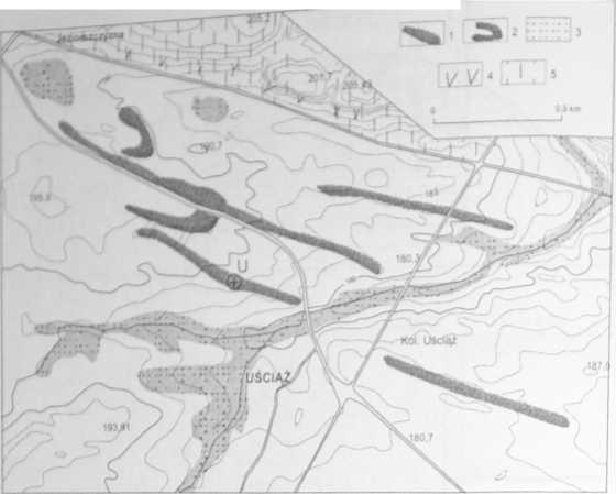
Fig. 4. Situation of dunes in the environs of Uściąż
1 - Pleni vistulian dunes, 2 - Late Glacial parabolic dunes, 3 - wetlands with Holocene accumulation, 4 - Nałęczów Plateau edge, 5 - loess cover Sytuacja wydm w okolicach Uściąża
1 - wydmy plenivistuliańskie, 2 - wydmy paraboliczne późnoglacjalne, 3 - strefy podmokłości z akumulacją holoceńską, 4 - krawędź Płaskowyżu Nałęczowskiego, S - pokrywa lessowa
The encroachment of parabolic dunes on dune ridges is a very interest-ing and important phenomenon occurring in the north-western part of the examined area, where one of two parabolic dunes encroaches and covers a part of the dune ridge. The parabolic dune is distinctly higher than the ridge. These two dune types are composed of two distinct groups of sand. Sand from parabolic dunes is typical of the Late Glacial dunes, i.e. loose, medium-grained, well sorted. The older, ridge forms are composed of less loose materiał, with a higher content of fine sand and silt, and clay interlayers; at the top it is silty sand (Fig. 5, Photo 2).
In the light ofthe TL dating (14.3 and 15.6 ka BP) the Uściąż sandy ridges should be related to the end of the Plenivistulian. This could have been the second, younger dune-forming phase during the Plenivistulian.
3.2.3. KAZANÓW DUNE AREA (RADOM PLAIN)
The Kazanów dune area is situated in the Polish Lowland belt, in its Southern part, in the Radom Plain subregion. Its morę detailed topographic and geomorphologic situation is presented in figurę 6. Two ridges having a gen-
Wyszukiwarka
Podobne podstrony:
DSC07877 (3) Fig. 2. Situation of dunes in the environs of Żuków (after J. Wojtanowicz 1999) I - dun
DSC07875 (3) Fig. 1. Distribution of inland dunes in Poland 1 - dunes and sand areas (Galon 1958), 2
Belgium 8 Fig. 1 oriented NE/SW in the east of the country and in a raore recent covering, disc
scan0017 (7) 346 HANDBOOK OF ECOTOXICOLOGY Figurę 14.4 Sources of petroleum and PAHs in the environm
o dBFrequency (Hz) l— SO* (high) SD* (Iow) Fig. 2. Mean hearing levels in the ieft
95 Ryc. 14. Podregiony rekreacyjne w rejonie Wigier Fig. 14. Recreational subregions in the Lakc Wig
VIII Międzynarodowa Konferencja NaukowaTOXIC SUBSTANCES IN THE ENVIRONMENT Kraków, 14-15 września 20
DSC06791 Ryc. 18. Miejsce objęte projektem z 2004 r. (jesień 2008) Fig. 18. Place included in the pr
S5004026 SE Brittin: Horse Fig. 2.6 Various coins mentioned in the text Coin and the representation
351 (20) 324Dress Accessońes Cockerel 1605 SWA81 3285 (2112) 12 fig 212 Incomplete; modelled in
DSC07881 (3) 50CU* Fig. 5. Profile of the Uściąż dune (situation marked with letter “U” in Fig. 4) 1
DSC07865 (2) Fig. 3. The thickness (in m) of Holocene deposits in various part of Vistula River vall
DSC07886 (3) 4. AGE OF THE PLENIV1STUL1AN DUNES; DUNE-FORMING PHASES In the light of the investigati
DSC07898 (3) Fig. 1. Labske piskovce (Elbę Sandsteine, Northern Bohemia) - one of the large sandston
S5002146 gp c [1 frag., Fig. 20:6), D [4 1 Fig. 20:2,3], H [1 frag.]. >n was carried out in the a
więcej podobnych podstron