IK 2

Rocks, Wrecks, Obstructions IK
|
16 |
/+ , Co + + ....... Co 5e |
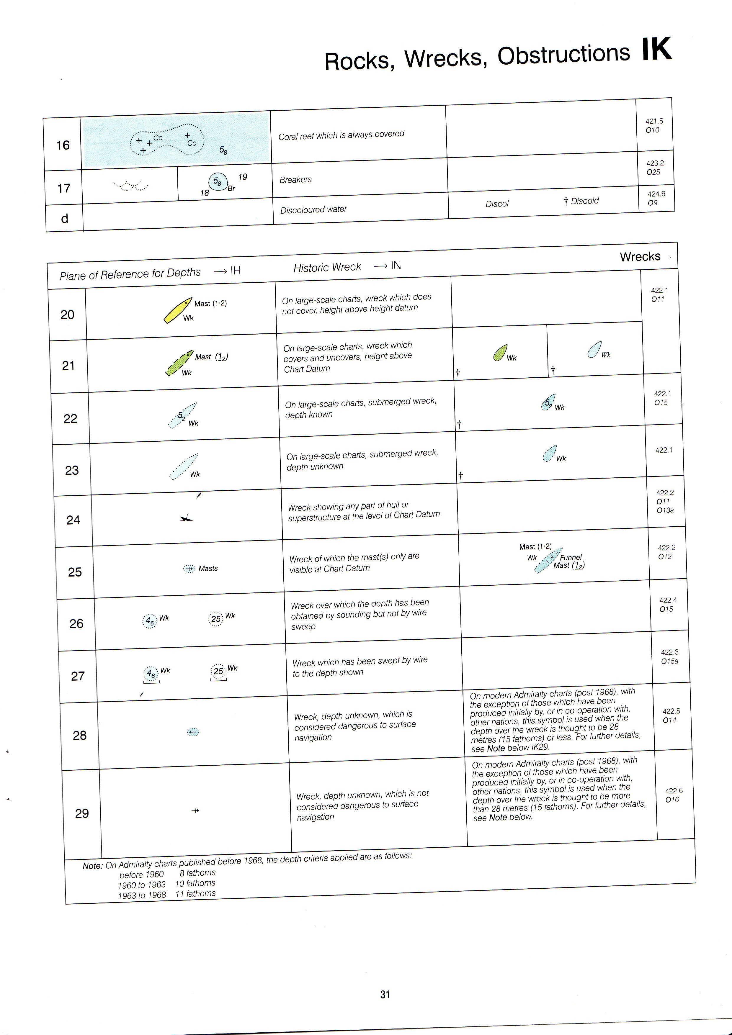
Coral reef which is always covered |
421.5 010 | ||
|
17 |
®L, W 18 ^Br |
Breakers |
423.2 025 | ||
|
d |
Discoloured water |
Discol t Discold |
424.6 09 | ||
|
Piane of Reference for Depths —* IH Historie Wreck —> IN Wrecks | |||||
|
20 |
Mast (1 -2) m |
On large-scale charts, wreck which does not cover, height above height datum |
422.1 011 | ||
|
21 |
,<f Mast (12) / s Wk |
On large-scale charts, wreck which covers and uncovers, height above Chart Datum |
t |
óWk t | |
|
22 |
wk |
On large-scale charts, submerged wreck, depth known |
lSwk t |
422.1 015 | |
|
23 |
/.••• ' Wk |
On large-scale charts, submerged wreck, depth unknown |
(ywk t |
422.1 | |
|
24 |
7 sC |
Wreck showing any part of hull or superstructure at the level of Chart Datum |
422.2 011 013a | ||
|
25 |
Masts |
Wreck of which the mast(s) only are visible at Chart Datum |
Mast (1-2) ... Wk ,y'y Funnel /".y Mast (1_2) |
422.2 012 | |
|
26 |
(46) ^ 25. Wk |
Wreck over which the depth has been obtained by sounding but not by wire sweep |
422.4 015 | ||
|
27 |
(46)Wk (25) Wk / |
Wreck which has been swept by wire to the depth shown |
422.3 015a | ||
|
28 |
Wreck, depth unknown, which is considered dangerous to surface navigation |
On modern Admiralty charts (post 1968), with the exception of those which ha\/e been produced initially by, or in co-operation with, other nations, this symbol is used when the depth over the wreck is thought to be 28 metres (15 fathoms) orless. For further details, see Notę below IK29. |
422.5 014 | ||
|
29 |
-H+ |
Wreck, depth unknown, which is not considered dangerous to surface navigation |
On modern Admiralty charts (post 1968), with the exception of those which have been produced initially by, or in co-operation with, other nations, this symbol is used when the depth over the wreck is thought to be morę than 28 metres (15 fathoms). For further details, see Notę below. |
422.6 016 | |
|
Notę: On Admiralty charts published before 1968, the depth criteria applied are as follows: before 1960 8fathoms 1960 to 1963 10 fathoms 1963 to 1968 11 fathoms | |||||
31
Wyszukiwarka
Podobne podstrony:
IK 1 IK Rocks, Wrecks, Obstructions General 1 Danger linę: A danger linę draws attention to a da
IK 3 IK Rocks, Wrecks, Obstructions Piane of Reference for Depths —> IH Historie Wreck —* IN
skanuj0179 16 1. Co to jest strategia i zarządzanie strategiczne stwa i podejmowanie, kontrolowanie
MĄDRZE CZYTAJ 2 16 1. Co to za roślina? Rośnie nad potoczkiem, mruga do nas niebieskim oczkiem
14698 P1060884 (2) 16 Co to Je U fleksja ? sformułowania, jak specjaliści zajmujący się chemią atmos
16 co prawda, że jednym z czynników zwiększonego zainteresowania się ćwiczeniami cielesnymi była
oV -1 0, 1& Oać 7 IH+f0,16+141 i 1+1,16 CO O, G<+7-A1IB- .om 141. UvTKl+)W7r SlftOft
16) co to skrzyżowanie; przeaęde lub połączenie dróg w jednym poziomie, umoźfiwiające peiny lub częś
Dziś w Głosie I Co przysługuje ofiarom wypadku w pracy? - str. 16 Co stopy j mówią o
16 Co za próżność u tego człowieka! Może się co do tego równać nieomal z ludźmi, stojącymi dziś na c
wzor17t S = OM = 16 - 8 co s 3 Kt
więcej podobnych podstron