
Promenade into the gap: Tokyo’s impossible void
Pedro Hormigo
1
*, Takao Morita
2
and Jean-Se´bastien Cluzel
1
1
Faculty of Engineering and Design, Kyoto Institute of Technology, Kyoto, Japan
2
Faculty of Engineering and Design, Kyoto Institute of Technology, Kyoto, Japan
This paper discusses the importance of gaps in urban space and cityscape. It proposes that gaps are
particularly important in high-density urban areas, testifying of the options for urban densification and
presents the case study of Tokyo’s J.R. Yamanote railway and Shibuya district to support this idea. In the
case of the J.R. Yamanote line – a railway with a concentric layout serving Tokyo’s central districts – we see
how gaps initially created under elevated sections of this structure gradually disappeared and became
occupied by new urban tissues, allowing urban growth to continue taking place in the city centre. In
Shibuya, where no more land was available, gaps were used to support a strategy of space usage
intensification. While physically transportation and commercial infrastructures appeared absorbing all gaps
between them, some amusement facilities such as a cable-car or a planetarium were the devices created to
expand the visual horizon beyond the increasingly dense urban space. These findings reveal that in such
processes, gaps have appeared, disappeared and in some cases reappeared to promote continuous urban
intensification processes essential to the preservation of urban centrality.
URBAN DESIGN International (2007) 12, 3–19. doi:10.1057/palgrave.udi.9000181
Keywords:
intensification; gap; emptiness; density; Tokyo; Japan
Introduction
How can we translate urban densification? How
do spaces reserved for displacement, spaces
where one stays or spaces serving both functions
articulate and juxtapose? Are the relations be-
tween these spaces supported by principles of
continuity or rupture? In other words, which are
the concepts that the urban planner, acting on the
transformation of the city, should apply when
confronted with issues as diverse as the concep-
tion of new spaces, the forecast of their effect and
relations with existing spaces or even issues
related with the preservation of urban heritage?
This study, centred on an in situ urban observa-
tion and on the historic evolution of some of
Tokyo’s districts, tries to answer these questions.
Here the issue is to find the words that would
allow us to express certain rules inherent to urban
development. Our analysis can be inscribed
within the continuity of research that has as a
goal the definition of spatial articulations, that
is, ‘the competence to build’ (Choay, 1992). We
have chosen as a reference term the word gap in
order to show that the separation between two
spaces is an essential rule to any spatial develop-
ment, in the same way as the term threshold
(Bonnin, 2000) has contributed for an under-
standing of spatial articulations in dwelling space.
This term gap will also allow us to stress an
evolutional tendency followed by some fast-
growth Japanese cities in their conquest for
space; a tendency that we could synthesize as
‘from the infinitely big to the infinitely small’.
Finally, the term gap will also allow us to answer
certain questions regarding conservation in the
contemporary transformation of the Japanese
cityscape.
Gap
The word gap means open or empty space, a
hiatus, an interruption in the continuity between
things, a separation, interval or breach. In its
*Corresponding
author.
Kyoto-shi
Sakyo-ku,
Tanaka
Monzen-cho 8-1, Hyakumanben, Haitsu 301, 606-8225, Japan.
Tel: þ 81-90-9610-3522, E-mail: phormigo@yahoo.com
URBAN DESIGN
International (2007) 12, 3–19
r 2007 Palgrave Macmillan Ltd. 1357-5317/07 $30.00
www.palgrave-journals.co.uk/udi

primary sense, it is used to express the existence
of a physical separation between two elements.
When associated with another word, the term gap
can also be utilized to characterize subjective
types of separations, for example, the case of
human communication problems. In fact, the
expression generation gap testifies to a lack of
exchange, a psychological and/or temporal
distance causing a rupture in communication
due to a mutual incomprehension. This distance,
which can be physical, temporal or psychological
is regarded as a source of rupture; however,
it mostly interests us in that it is often perceived
in a negative way whereas it could instead
have, as a consequence, a positive result: that
distance actually allows the preservation of a
certain peace.
The study of these gaps can be particularly
interesting in the case of high-density urban
tissues, since in their sense of separation or
distance – such as they exist in human relations
– they become essential to all cohabitation of
urban space. They thus become important
options for urban intensification or densification.
Firstly, we will consider the evolution of the gaps
between the various buildings that compose the
Shibuya station in Tokyo. Secondly, we will focus
on gaps that were necessary to isolate high-speed
circulation roads from the urban tissue. For this
purpose, we have chosen the example of the
Yamanote line in Tokyo and the evolution of the
land plots under its elevated sections. We will see
that in Tokyo this type of land has been rapidly
utilized.
Finally, even if gaps are essential elements to
urban intensification and densification, we will
also attempt to demonstrate that in the Japanese
city they have a particular value. With this in
mind, we will return to the Shibuya district to
propose a hypothesis that the disappearance of
the two previously mentioned types of gap might
bring about their replacement by new ones, but in
a different form.
Empty spaces or gaps?
The City in History (Mumford, 1961) describes the
constantly growing need for space in cities as
characteristic of their development. In this work
of reference that deals essentially with urban
issues, Mumford shows in a duty-bound fashion
that the spatial expansion of cities followed two
main principles:
1
the occupation of a sprawling
urban territory and the multiplication of levels,
that is, a development in strata or layers. Today,
the observation of urban agglomerations reveals
that these two principles of expansion still
prevail, applied in different proportions accord-
ing to the type of urban area.
Mumford also stressed the correlation between
building density, territorial expansion and the
development of rapid transportation systems. His
work, more than showing that the conquest of
new territories went together with the densifica-
tion of urban centres, explains that both develop-
ment
principles
were
accompanied
by
a
transformation of the transportation networks at
a quantitative and qualitative level; a transforma-
tion that was ultimately brought about by the
development of new speeds of displacement.
The urban tissues dislocate as the opening of
roads for rapid circulation attempts to respond to
traffic congestion problems in the metropolis.
Mumford will give to this historical and global
reality the name ‘urban devastation’. With the
same tone, he criticizes certain new urban devel-
opment projects; road interchanges are called
‘space eaters’ – a term or argument that was
utilized by a great number of other critics.
On the race to urban decongestion of the past two
centuries, the great novelties were connected with
the development of circulation networks. The
more the metropolises were transformed into
megalopolises, the more those new developments
became detached from the original urban tissue,
that primary layer, in elevated or underground
secondary layers. Those secondary layers appear
with the construction of viaducts, depressed
roads or tunnels: a multitude of means allowing
the isolation of the different speeds of displace-
ment.
2
Today, all the megalopolises are equipped
1
In fact, Mumford insists mostly on the first principle.
2
In the layout of this infrastructure, the different speed levels
had, as a corollary, the creation of spatial gaps between the
different types of circulation roads. Thus, the roads brought
about new forms of space occupation and articulation. It
becomes clear that in the conception of these multilayer urban
spaces, the absence of analytical models or methodologies is
caused by the unavailability of any forecast for serious space
management, a fact that Mumford severely criticized, but a
task to which professors such as Bill Hillier (Hillier and
Hanson, 1984; Hillier and Furuyama, 2003) devote themselves
today.
Promenade into the gap
P. Hormigo et al
4
URBAN DESIGN International

with this type of network in secondary layers,
where the demand is for rapid circulation speeds.
It would thus seem that in this transformation
process – also characterized in La vitesse de
liberation (Virilio, 1995) – the layout of roads in
secondary elevated layers would lead to the
appearance of derelict or empty spaces on the
primary layer: ‘waste spaces’ (Lynch and South-
worth, 1990). Would then these new infrastruc-
tures also be worthy of the name Mumford
attributed to them: ‘space eaters’? It is only once
we give them a function that they finally lose that
image and start being considered true spaces.
However negative these denominations might
sound, we must nevertheless ask if they are
simply spaces to suppress from cities. When
Mumford looks into the future, he recognizes
wasted urban space potential, so finally do not
these ‘wasted spaces’ become transformed by
‘space eaters’ into something else? Should not
these spaces be studied to examine what funda-
mental interactions they carry out inside cities?
In urban development processes, the study of
interactions between layers or spaces could help
us understand the effect that the addition of these
elements can produce. We will try to show how
the secondary layers impact upon their immedi-
ate environment, or to put it more simply, what
are the impacts of a viaduct over a city’s primary
layer? Most of all, we will try to clarify what sort
of gaps this infrastructure induces, in which way
these gaps are preserved, how they disappear and
then reappear.
For this study, we have chosen Tokyo’s central
district – an area that counts among the world’s
highest for densities of occupation. Tokyo’s
complex road network – superimposing multiple
levels of road, railway and pedestrian passage-
way – achieves a paroxysm. This is a crucial
aspect of our study, considering that the relations
between spaces for circulation and other types of
spaces pose important questions regarding densi-
fication (Jacobs, 1961; Glaeser, 2000).
3
The gaps addressed by Mumford, upon which
Choay (1969) casts a theory, were those of the
Western cities. In The Hidden Dimension Hall
(1966) confronts some particularities of Japanese
space culture with those of the West. Two decades
later, The Hidden Order (Ashihara, 1989) attempted
to explain the logic and certain rules in Tokyo’s
urban tissue. The choice of the Japanese capital
might unveil some differences between its gaps
and those found in the West.
Promenade through some of Tokyo’s
gaps
In the following pages, we will walk through
several districts in Tokyo. From the start, we
proposed re-reading the main stages of urban
development in the great amusement district that
corresponds to Shibuya and its station area. We
will see how many gaps have been absorbed by
the construction of increasingly larger, taller and
therefore, denser building masses. As we exit the
Shibuya station, we will begin a promenade
through Tokyo, along the Yamanote railway
(Tokyo’s loop line). This line’s concentric layout
will allow us to identify the different qualities of
spaces below its viaduct sections and also to
perform a primary classification of the gaps
existing in those areas. Finally, we will walk back
to Shibuya and see that this district’s ‘places of
memory’, which are the secretion of history, are
themselves gaps. Finally, in a moment of pause
we will find ourselves facing the impossible void.
The ‘space eaters’:
4
the Shibuya station and the
department store.
Today, Shibuya is one of Tokyo’s main commercial
districts. In the first place, this centrality is
geographical, but Shibuya has been for a long
time the meeting point of roads and railways,
which rendered it suitable for a commercial
development that further accentuated its centrality.
In this district, we are particularly interested in
two aspects: its high density and its amusement,
information and commercial activities. Here,
where territorial expansion is no longer possible,
Shibuya has no option other than increasing its
3
Density-increase as a constructive approach to urban
problems particularly in the American city, is referred by Jane
Jacobs in The Death and Life of Great American Cities particularly
in the section ‘The need for concentration’.
4
We borrow again this expression from Mumford in its sense
of space consumption.
Promenade into the gap
P. Hormigo et al
5
URBAN DESIGN International

density. Within this context, the Shibuya district
as it stands today is a testament to developments
in infrastructure that serve the purpose of
optimizing the possibilities for spatial efficiency
and urban development.
Historically, even if Shibuya only became a
district of Tokyo in the beginning of the 20th
century, it was already an important crossing
point between the downtown Edo
5
and its
periphery. However, Shibuya was not merely an
important thoroughfare but also the place where
many agricultural goods were produced and
where their distribution was organized. Thus,
the Shibuya of the Edo period
6
was a dynamic
and developing area (Shibuya, 1952).
At that time, the high areas of Aoyama and
Setagaya were the base of samurai and other
residences for the nobility. Today, those areas are
the base for important companies and their
commercial activities.
The road network dating back from the Edo
period would greatly contribute for the develop-
ment and expansion of Shibuya. As previously
mentioned, Shibuya’s important role as thorough-
fare originated in the Koˆshuˆ Road,
7
one of the
country’s five main roads. Originally created with
a military purpose, this road was in reality used
mostly for the transportation of goods and people
between the Setagaya hill and the centre of Edo
(Akai, 1976). Another important road crossing
Shibuya was the O
ˆ yama
8
road. In the Edo period,
the presence of these important roads attracted an
increasing population and more commercial
activities, not only in this district’s low and
central areas but also in other nearby areas such
as Yoyogi and Shinmachi.
In 1885, the opening of Shibuya station
9
acceler-
ated the development of activities in this district.
Meanwhile, that station assumes a primordial role
as part of an increasingly complex machine: the
train allowed the development of new commer-
cial activities that were themselves highly depen-
dent on the increase of user frequency. If in the
beginning of the 20th century, small factories and
workshops started concentrating in the central
area by the Shibuya river, they would later on
change location or disappear, as the number of
people frequenting this area was accompanied by
a larger number of services – Shibuya became the
centre of commercial activities (Hagawa, 2000).
The development of Shibuya’s urban tissue was,
as in the whole of Tokyo, completed in phases
following, for example, successive crises, fires or
rapid industrialization. In 1923, the great Kantoˆ
earthquake was a particularly devastating event
that was followed by an important period of
reconstruction.
The Second World War destroyed large portions of
Tokyo including part of the Shibuya district
(Ishikawa, 1992). Soon the whole city would be
the target of reconstruction and many areas would
be renovated. While the new buildings replaced
the old or destroyed ones, a great effort was put
into the city’s transportation infrastructures. In the
case of Shibuya, these infrastructures associated
with large-scale department-store-type commercial
facilities. The owners of these commercial giants
were in most cases the owners of the transporta-
tion companies.
10
After the implantation of these
first commercial facilities, a department store
boom would take place in Japan in the years
following the war. The pre-war department stores
and commercial facilities become bigger, more
complex and started offering, in the same space,
cultural and amusement activities. The accessibil-
ity to a multitude of services in a concentrated area
becomes the unrivalled image of Shibuya. The
developments in railway transportation assured, in
this area, support to the growing number of
commercial activities. In that sense, these struc-
tures naturally pushed for the concentration of
activities close to the stations and consequently to
an increase of the building volumes. At Shibuya,
for services and commerce, the station area was
‘the place to be’.
5
Old denomination for Tokyo until 1868, when it became the
capital of Japan.
6
Edo period: 1603–1868. Period corresponding to the
Tokugawa shogun’s rule.
7
Koˆshuˆ Kaidoˆ, road connecting Edo to Shimosuwa, located
in today’s Nagano prefecture.
8
O
ˆ yama Kaidoˆ, road connecting Edo to today’s Kanagawa
prefecture.
9
The first railway in this area belongs to the present J.R.
Yamanote line.
10
In Japan, other than the initially state-owned national
railway company, there are several other private companies
(Cf Aoki, 2002).
Promenade into the gap
P. Hormigo et al
6
URBAN DESIGN International
For a long time, railway companies in Japan have
invested in domains other than mere transporta-
tion.
11
Undoubtedly, they soon realized that their
stations were strategic commercial locations and
that a financial investment in this commercial
segment could represent a substantial increase in
their revenue. Thus today in Japan, railway
companies are the owners of the majority of the
department stores and real-estate developments
adjoining the stations
12
(Tiry, 1997; Aveline, 2003).
In this sense, these companies play an important
role in Tokyo’s urbanization and in the creation of
a contemporary cityscape.
In Shibuya, the Toˆkyuˆ company had a prominent
role in the transformation of space and cityscape.
In 1934, this railway company opened its first
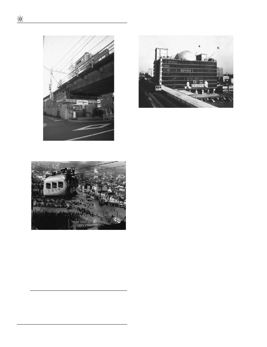
department store (Figure 1) adjoining the Shibuya
station.
13
From that initial building, the Toˆkyuˆ
company would gradually extend its commercial
activity and facilities. Other railway companies
established in Shibuya and all over Japan would
privilege the same successful model of growth,
building their own commercial facilities in the
areas adjoining their stations (Miyata and Haya-
shi, 1985). In 1954 Toˆkyuˆ opened its new building
that extends over the Ginza line station, which
itself opened in 1938 (1, 12 No. 1). We can suggest
that the new building ‘swallowed’ the Ginza line
station in the process.
In the same way, through the 1960s important
urban modifications connected with the organiza-
tion of the 1964 Olympic games had a deep
impact over Tokyo’s cityscape in general and
particularly at Shibuya. An elevated highway
14
passing through the centre of Shibuya just beside
the south side of the station was a new infra-
structure addition to the already existing train
and subway lines.
15
This infrastructure, in the
shape of new viaducts, responded to saturation
problems at the primary layer. They demon-
strated that once the development at the ground
level became impossible, a growth potential
remained available in layers to be created above.
This conquest of secondary layers, which allowed
for an important increase in the flux of people and
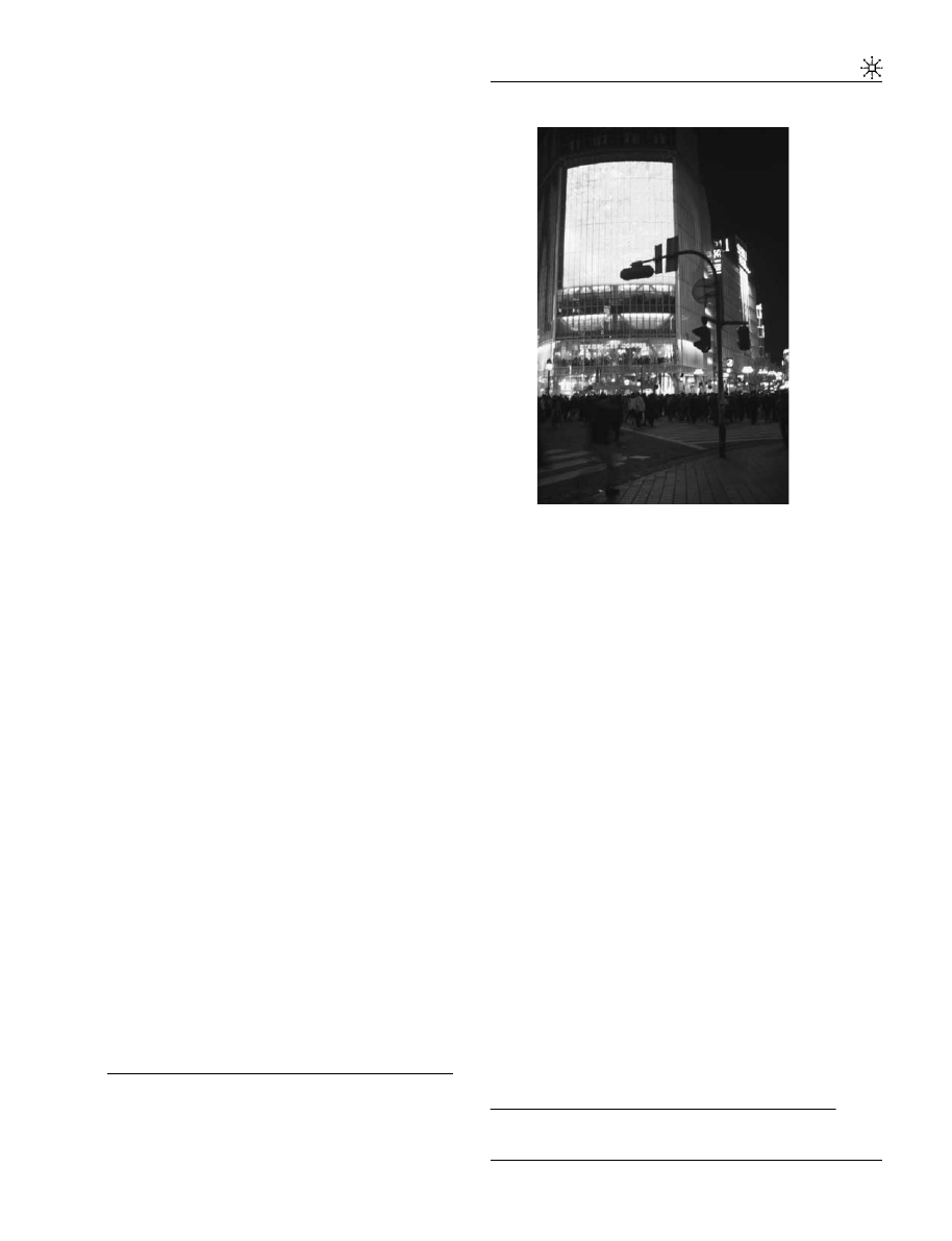
goods, was accompanied by the Toˆkyuˆ company’s
devouring appetite for space around its stations.
Concentration would be intensified by a densifi-
cation: the ‘space eaters’ (Figure 2) sat at the table,
there they would remain.
Recently, a 25-storey hotel and shopping centre
complex was added immediately west of Toˆkyuˆ’s
two buildings and over the Inokashira (Keioˆ) line.
These two last extensions, the Mark City and the
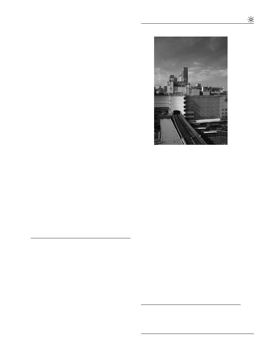
Figure 1. The Shibuya station and the department
store. View of the Ginza subway line entering the
Shibuya station, above which stands Toˆkyuˆ Toˆyoko
Department Store complex.
11
The diversity of activities undertaken by the same
company seems to be the result of a tradition in Japan. O
ˆ ta
shows that already in the Japanese medieval period, carpenter
guilds controlled the wood production network, a part of the
necessary infrastructures for its transportation and even entire
villages between the production territories and the places
where the wood was utilized (larger cities). For this aspect, see
in particular, the chapter 9 ‘Zojishi and mokuryoˆ’, chapter 16
‘Za, architecture guilds’ and chapter 25 ‘Master -builders in the
modern age’ in O
ˆ ta’s capital work in the history of Japanese
architecture: O
ˆ ta Hirotaroˆ, Nihon kenchiku-shi josetsu, Introduc-
tion to the history of Japanese architecture, Shoˆkokusha, Toˆkyoˆ,
first edition 1946, last edition 1989.
12
Please refer to the work of Natacha Aveline on real-estate
policy and the great railway companies in Japan. Also refer to
the research undertaken by Corinne Tiry on the real-estate
concentration developments around Japan’s largest train
stations.
13
The location of this store corresponds to today’s Toˆkyuˆ
Toˆyoko Department Store East Building.
14
Metropolitan Expressway No.3 (ME3).
15
Today, there are six train and subway lines operating in
Shibuya: the Yamanote line (J.R.), Saikyoˆ (J.R.), Toˆyoko
(Toˆkyuˆ), Inokashira (Keioˆ), Ginza and Hanzomon (subway).
Promenade into the gap
P. Hormigo et al
7
URBAN DESIGN International
Excel Hotel Toˆkyuˆ tower were inaugurated in
2000.
Facilities such as the Toˆkyuˆ Toˆyoko Department
Store are punctual real-estate developments along
the train lines. The study of the evolution in this
kind of district and its buildings brings us some
clues to the relations between people and space in
Tokyo.
If we compare the Toˆkyuˆ Toˆyoko Department
Store’s West Building as it was in the 1950s and
now, we can see important changes. In the 1950s,
the buildings were connected by various bridges.
Such transition spaces appeared outside the
buildings, in open spaces: interstitial spaces. At
that time, there were gaps between the buildings
built in 1934 and 1954.
Today, for the users of Shibuya station, the
changes between trains from different companies
take place inside the buildings, without passages
through an outside space. However, the new
pedestrian circuits inside this giant station pre-
serve inside this territory a large number of gaps.
The transition between different trains from
different companies still requires a ticket change,
the passage through ticket control barriers, some
minutes walk and often the shift between many
levels – aspects that represent an immense variety
of gaps. These buildings would eventually be-
come themselves passageways, connecting all
sorts of functions. Even if they seem to form
now a ‘continuous space’, this continuity is but a
mere illusion since the gaps they envelop are
merely disguised. For the pedestrian, only the
climatic gap has disappeared: the need to ‘exit’, to
pass from the ‘inside’ to the ‘outside’ has ceased
to exist.
If we compare the past and present pictures of the
Toˆkyuˆ Toˆyoko Department Store and station
complex, we can see another important transfor-
mation in the gap between the inside and the
outside. For instance, in the past, the fac¸ades of
this store’s East and West buildings were origin-
ally designed with generously large windows. By
contrast, presently these fac¸ades became blind,
their windows were sealed and their volumes
closed in, often enveloped by large size bill-
boards; changes that impede any sort of visual
communication between the inside and outside.
This phenomenon corresponds to a final stage of
space consumption: the relation with the outside
is no longer fundamental. Architecture became
hermetic. Here the gap between inside and
outside is more clearly stated than ever before.
Today, the Shibuya station is a large-scale real-
estate complex composed of several buildings
connected by tunnels and pedestrian passage-
ways. The railways intersect in different elevated
or underground levels. Station platforms are
connected by escalators, passageways and tunnels
– interior streets in a true sense. Some station
platforms extend all the way south until they are
overlaid by the Metropolitan Expressway No. 3
(ME3). The surrounding streets are also equipped
with a series of infrastructures that overlay each
other. All these paths are marked by the presence
of devices providing all sorts of information that
help people understand the relationships between
the most diverse places and functions. The
information, which is superimposed onto the
urban functions, ends up further increasing the
intensificaction in the usage of space.
The transformation of lost spaces: 150 m apart
from the nodes of a concentric line
When describing nodes,
16
Lynch (1960) empha-
sized that they tend to form at the junctions of
significant roads. Rail transportation infrastruc-
tures that belong to secondary layers also have
important effects not only on the nodes they serve
but also on other less immediate areas.
Figure 2. The ‘space eaters’. Representation of the
Shibuya station and its department store.
16
Nodes such as railway stations or other places where
people come together.
Promenade into the gap
P. Hormigo et al
8
URBAN DESIGN International

Choay
17
suggested similarities between the effects
of a medieval town’s walls and those of a Parisian
elevated railway. Such similarities seem appro-
priate for this discussion. In today’s cities, barrier
effects caused by viaducts are particularly felt and
seen at the street level. Whether they constitute a
physical or visual barrier, elevated roads often
accentuate communication problems in the urban
tissue between its two sides, projecting over the
primary layer functionless empty spaces that
fragment the city.
The usages and functions attributable to these
residual spaces were subjects of discussion in a
period of reflection that followed great infrastruc-
ture development projects in many Western cities
(Halprin, 1966). Nevertheless the question of how
to use these empty spaces was always approached
in a critical way, denouncing the waste of space.
Indeed, until recently the discussions were mostly
focused on the shape of the infrastructures
themselves (Appleyard et al, 1964). Today, one
can criticize the designers of such structures for
not having considered sufficiently their interac-
tion with the city. This brief reminder on the
discussion topics concerning this subject shows
the way this infrastructure was conceived, or
better said, the way they were not, because the
problem of managing the interactions between
these structures and the city was not satisfactorily
addressed.
It is thus from these empty spaces – which are
somehow unexpected because they seem to
contradict the intensification process itself – that
we will try to see if the reason why they are empty
is not exactly because they are merely expectant
spaces, waiting to interact with the city.
To deem how a city can integrate residual spaces
created by viaducts, it seems necessary to identify
some of these empty spaces. The centre of Tokyo
is again the choice to perform this research; since
in this environment, it would seem that residual
spaces have in many cases found functions that
rehabilitate them to a status worthy of the title space.
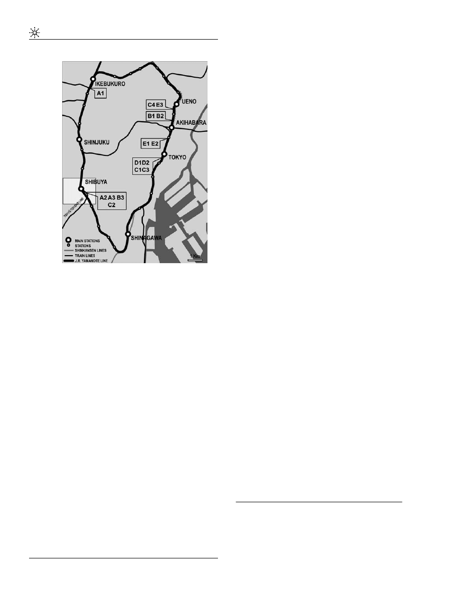
The geography of the promenade
In this Tokyoite promenade (Figures 3 and 4), we
have tried to identify the barrier and permeability
effects induced by the concentric J.R. Yamanote
line.
18
We have also extended our research to
crossing areas between this line and other rail-
ways and highways.
The Yamanote line will illustrate how the residual
spaces induced by the creation of an elevated line
were absorbed and what sort of interaction they
preserve today with the primary layer of the city.
To avoid any confusion with the nodes, the sites
chosen for analysis are located systematically
more than 150m apart from the stations.
This research took place from February 2001 to
December 2002. The data gathered and analysed
are based on notes, drawings, photographs and
maps. The promenade begins at the Shibuya station
and proceeds clock-wise towards the Shinjuku
station. As we have just mentioned, this walk does
not merely take into account the Yamanote line but
also junction and intersection areas with the
following lines: J.R. Sobu line at the Akihabara
station; Toˆkyuˆ Toˆyoko line at the Shibuya station;
J.R. Keihin Toˆhoku line close to Akihabara
station; J.R. Toˆkaidoˆ (Shinkansen) line at the Tokyo
station; J.R. Toˆhoku Joˆetsu (Shinkansen) line
between the Kanda and Yuraku-choˆ stations.
The selected railway sections rest over elevated
structures, sometimes decades old. It seems that
in many of those sections such a period of time
sufficed for these residual spaces to spin specific
urban relations with their surrounding areas.
Each site is presented by the shape of a schematic
cross section (Figures 3-1, 3-2 and 3-3), allowing
the identification of the conditions between both
sides of the viaduct and thus – according to the
types of physical occupation, dimension and
function of these spaces – the level of urban
permeability under the viaducts.
From section A2 to B3 (see Figure 3-1), the spaces
below the viaduct are occupied by single units.
The land plots are sometimes fenced; however,
despite offering no physical permeability, they do
allow visual permeability. They are either acces-
sible from one or two sides. In some cases, visual
permeability is obstructed once a space is occupied
by a building. All sorts of activities take place:
offices, small shops or mere storage of goods
17
Choay (1969, op.cit).
18
This line will hereafter be referred to as Yamanote line.
Promenade into the gap
P. Hormigo et al
9
URBAN DESIGN International
inside buildings, while car parking or construction
material storage occurs on any open space.
From section C1 to C4 (Figure 3-2), the spaces
below the viaduct are also thoroughfares. For this
reason, they become strategic places for commer-
cial activities, attracting people and therefore
participating in the creation of a dynamic urban
life.
From section D1 to E3, the viaducts’ width allows
more complex occupation schemes such as gal-
leries. The viaduct assumes the role of axis in a
new urban development, initially liberating a
strip of land – limited in terms of occupation in
height – that later on attracts new commercial
activities allowing the revitalization of some areas
inside the city.
These diagrams clearly show that the viaducts
that initially have produced empty spaces, end by
supplying spaces to which it is possible to
attribute different functions. Accordingly, to those
functional variations – represented in the sche-
matic sections – they correspond to changes in
terms of interaction and permeability with the
existing urban tissue.
The Yamanote line shows us that in this case,
what appear to be residual spaces barely resist
occupation. For instance, immediately after the
completion of the Toˆkyuˆ Toˆyoko line’s elevated
sections, small industries and workshops started
occupying the spaces below the viaduct close to
the Shibuya station. A similar situation exists
under the Yamanote line. The occupation of these
land strips has never ceased to increase to this
day. Presently, the type of activities has shifted
mostly to backstage services such as express mail
companies, warehouses, garages and parking
lots or front stage services like clothes shops,
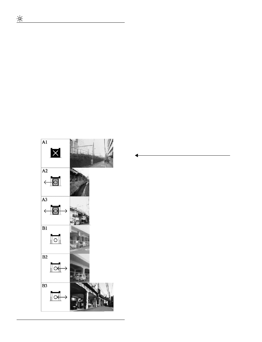
Figure 3. Types of urban interaction below the viaducts
of the J.R. Yamanote (loop) line. Circle marks corre-
spond to accessible spaces whereas cross marks
correspond to inaccessible ones. [Figure 3-1] A1 to
B3: simple units. The rampart: A1: Between the Mejiro
and Ikebukuro stations. This site is representative of a
rampart effect. No passage is possible between the two
sides of the railway, all views are obstructed by the
rampart. The viaduct: an empty space? A2 to E3
Sections A2 to E3 present different types of physical
and visual permeability. Here the height of the viaduct
allows the passage of pedestrians, cars or the construc-
tion of buildings. A2: The Toˆkyuˆ Toˆyoko line, approxi-
mately 150 m south of Shibuya station. The entrance
into the space below the viaduct is made from only the
entrance of the building that occupies it. A3: The Toˆkyuˆ
Toˆyoko line, approximately 250 m south of Shibuya
station. Entrance possible by both sides. Again the
building occupies the space obstructing the view to the
other side of the viaduct. B1: The Toˆhoku Joˆetsu
(Shinkansen) line, running parallel to the Yamanote
line, approximately 300 m north of the Akihabara station.
Limited physical permeability with only an entrance point
from one of the viaduct’s sides (door). The wired fence,
despite limiting physical permeability, assures visual
permeability. B2: The Toˆhoku Joˆetsu (Shinkansen) line,
running along the Yamanote line, approximately 250 m
north of the Akihabara. No entrance points, visual
permeability again assured by a wired fence. B3: The
Toˆkyuˆ Toˆyoko line, approximately 150 m south of
Shibuya station. Open access to the space, despite no
physical permeability to the opposite side of the viaduct.
Once more a wired fence assures visual permeability.
Promenade into the gap
P. Hormigo et al
10
URBAN DESIGN International
convenience stores (Figures 5 and 6 No. 2) or even
bars that now occupy some of these spaces.
In Tokyo, if a viaduct’s width allows it, new urban
formations can take place. Even if some of these
spaces continue resisting intensification of activ-
ity, their occupation is foreseeable in the near
future. This disappearance will naturally be
accompanied by a decrease in visual permeability
– similar to the effect of a town’s wall – but not
forcefully by a decrease in physical permeability
as we have seen.
The case of Tokyo revealed that these ‘empty
spaces’, born from problems of cohabitation
between different types of circulation, have a
great potential for development. In addition,
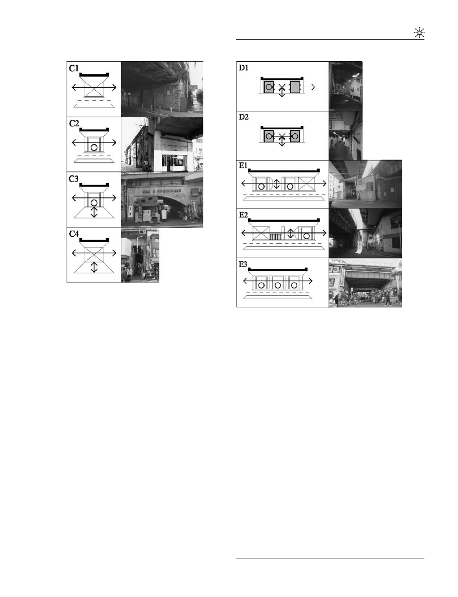
Figure 3-2. Continued C1 to C4. Thoroughfares and
their
additional
functions:
simple
units.
C1:
The
Yamanote line running along the Toˆkaidoˆ (Shinkansen)
line, approximately 100 m south of Tokyo station.
Thoroughfare for cars and pedestrians, visual perme-
ability. C2: The Toˆkyuˆ Toˆyoko line approximately 400 m
south of Shibuya station. Thoroughfare for cars and
pedestrians, visual permeability, a shop is installed
below the viaduct. C3: The Yamanote line running along
the Toˆkaidoˆ (Shinkansen) line, approximately 50 m
south of Yurakuchoˆ station. Pedestrian thoroughfare.
Initially, the thoroughfare offered visual and circulation
permeability. Meanwhile, a construction appeared occu-
pying half of the open space and that permeability was
reduced. C4: The Yamanote line running along the
Keihin Toˆhoku line, approximately 150 m south of Ueno
station. Identical to that of C1, however in this case, the
thoroughfare is limited to pedestrian circulation.
Figure 3-3. Continued D1 to E3. The development of a
new urban tissue: multiple units. D1 and D2: The
Toˆkaidoˆ (Shinkansen) line, running along the Yamanote
line, approximately 500 m south of the Tokyo station. A
pedestrian street runs below the viaduct. Buildings with
2–3 storeys high are aligned along that street. There is
no visual permeability between the two sides of the
viaduct. Buildings can be accessed from both under and
outside of the viaduct (D1) or merely from under it (D2).
E1 and E2: The Yamanote line running along the
Toˆkaidoˆ, the Joˆetsu and the Keihin Toˆhoku lines,
between the Akihabara and Tokyo stations. E3: The
Yamanote line running along the Keihin Toˆhoku line,
approximately 100 m south of Ueno station. E1, E2 and
E3: A street crosses the viaduct, allowing visual
permeability between its two sides. Interior service
streets along the viaduct allow the passage of pedes-
trians and cars.
Promenade into the gap
P. Hormigo et al
11
URBAN DESIGN International
if in Tokyo the spaces under viaducts were
deemed differently from those in the West, this
is also due to a specific real-estate policy under-
taken by the railway companies, who by all
possible means – for instance by renting these
spaces
19
– attempt to maximize the profitability of
these assets.
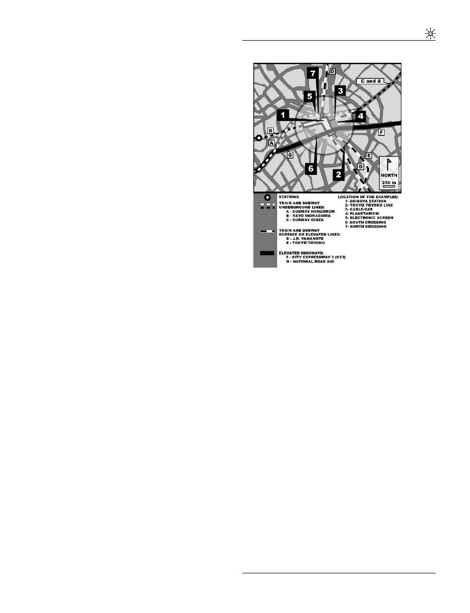
The ‘places of memory’ of Shibuya
Some years ago, Nora (1997) reminded us that the
places of memory were the secretion of history.
Today, memoirs and descriptions by travellers
who came to Shibuya remind the historians,
which were the places and attractions that
marked the development of this commercial and
amusement district. Two such places seem to
clearly show the particularities of Shibuya’s
development throughout the second-half of the
20th century: the cable-car and the planetarium.
Until now, we have seen that the intensification of
space occupation by buildings has restricted
visual permeability– as in the case of the devel-
opments under the elevated railways – however,
with the gradual development of a hermetic
architecture, another gap gained importance: that
of the separation between the inside and outside.
It seemed to us that here the places of memory –
the cable-car and the planetarium – and the gaps
they bring into play, might reveal the devices
utilized as attempts to escape a saturated physical
space (Tuan, 1998).
The streets of Shibuya are today a succession of
ramparts, railways, highways and pedestrian pas-
sageways. At the same time, an advertising
strategy that encourages the commercial develop-
ment of this district contributes to the affirmation of
Shibuya’s identity as an urban centre. It was only
recently that electronic screens showing commer-
cials the size of entire fac¸ades began invading the
city; however, their impact was immediate in that
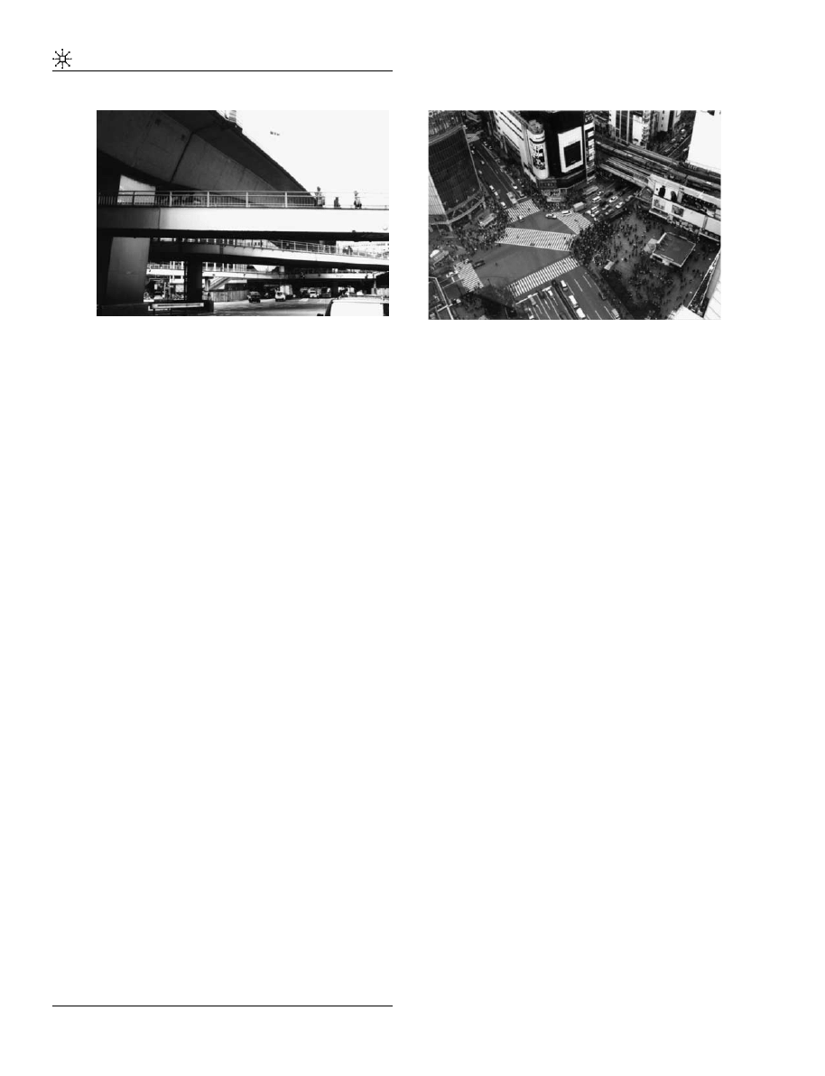
Figure 5. The cable-car, 1952.
Figure 6. The planetarium. The Toˆkyuˆ Bunka Kaikan
building, 1956.
Figure 4. Convenience store, Toˆkyuˆ Toˆyoko line, 2002.
19
On real-estate policies by railway companies in Japan,
particularly for the case of the ‘koˆka’ (elevated railways) see
Aveline op. cit. ‘La location immobilie`re’, p. 99. On the topic of
spaces under elevated highways whose design has been target
of more participation from local communities, refer Yamamoto,
(1995).
Promenade into the gap
P. Hormigo et al
12
URBAN DESIGN International
they changed the way people visually perceive
Shibuya’s contemporary cityscape.
In the following examples, we will find that the
increase in building volumes was accompanied
by the appearance of new gaps utilized to escape
the restrictions on the visual range. This type of
action/reaction had been suggested by Paul
Virilio (1984).
The cable-car
In the first years that followed the Second World
War, the centre of Shibuya, also affected by
the air raids was in fast recovery. Surrounding
the Toˆkyuˆ Toˆyoko Department Store and the
station, which had been spared by these attacks,
the crowds seethed in (black) markets that
popped out close to many of the railway stations
(Figure 7 and 12 No. 3).
In 1950, in the midst of a city in reconstruction,
the Toˆkyuˆ Toˆyoko Department Store inaugurated
a new attraction: a cable-car connecting this
department store’s terrace
20
to the Tamaden
Building.
21
The cable-car nicknamed Hibari-go
performed a round trip covering a distance of
approximately 350m (Figure 7).
The accessory quality of this means of locomotion
is clear and pertinent in this discussion: neither
distance nor time spent to reach it were signifi-
cantly gained by comparison with the speed and
time taken by a pedestrian on the street for the
same distance. The investment involved in its
construction testifies the importance that these
attractions had for the increase of visitors in these
shopping centres. During a short period of three
years, after which this cable-car attraction was
closed, only a generation of young travellers – this
attraction was limited to children use – could
have a foretaste of what Shibuya’s future citys-
capes would look like. This facility was one of the
first where one could experience an aerial
perspective. Also it should be of interest to note
that it was the creation of a gap that was chosen to
attract the crowds. This separation in height
spatially corresponds to a physical gap: the
distance from the cabin to the ground. This in
turn allowed for a visual gap: the offer of an
‘extraordinary’ view that allowed the spectator to
escape from his/her ‘ordinary’ everyday view of
the city.
At that time, the density and volume of construc-
tion was increasingly connected with Shibuya’s
image. It is quite easy to imagine that Shibuya was
therefore one of the districts where visual escapes
became more difficult to find. It is in this con-
text that the Toˆkyuˆ company, undoubtedly aware
that this issue could provoke a general feeling
of claustrophobia on its customers, attempted to
avoid that possibility through the opening of a new
horizon offered from the cable-car. Shibuya was
the place of all contrasts: from a densification taken
to a paroxysm, one could come in search of a
panoramic view of all Tokyo.
The planetarium
In Shibuya, the race for devices that allowed the
reinvention of gaps between people and the
world had therefore been set in motion. In 1953,
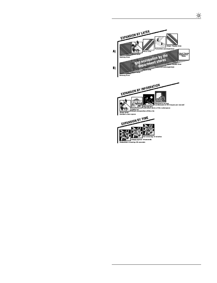
a new attraction was inaugurated in the new
Toˆkyuˆ Department Store’s building
22
(Figure 8
and 12 No. 4): the Gotoˆ Planetarium. This
attraction followed the directions of the cable-car
Figure 7. Electronic screen at the Q-front building,
Shibuya station’s North exit, 2002.
20
Today referred to as the Toˆkyuˆ Department Store East
Building.
21
Today’s Toˆkyuˆ Department Store West Building.
22
The ‘Toˆkyuˆ Bunka Kaikan’ (Toˆkyuˆ Culture Hall) building.
Promenade into the gap
P. Hormigo et al
13
URBAN DESIGN International
device, whose purpose was to offer a panoramic
view of the city.
The cable-car invited its young passengers to move
from a dense physical space – the streets and the
interior space of buildings – to the contemplation
of an immense extension. With the Planetarium,
however, the travellers departed from everyday
spaces to experience the infinitely big.
From a limited real space, to the limitlessness of a
virtual one, this time the trip was available to all.
Elsewhere, as in Japan, the planetarium probably
marks an age when we try to draw away the
physical limits of our territories. If we compare
the planetarium with the cable-car, it is note-
worthy that while the physical gaps did not cease
to decrease, the gaps between the real and the
virtual were continuously multiplied. The trips
proposed in the planetarium were free from the
physical variables on which the cable-car de-
pended – all movement was abolished and the
spectator was still.
Once again, by the use of contrast against a
density that had reached a paroxysm, this new
dimension contributed for the establishment of
Shibuya’s future image: only here such a new
range of universes could be available. From
inside Shibuya we could now have access to
views of an outer space.
The success of these two initial attractions would
definitely contribute to turn Shibuya into the
breeding ground for new devices devoted to
territorial production – territories whose limits
went beyond mere physical constraints.
The electronic screens
Previously, we have seen that the department
stores were responsible for the absorption of the
gaps surrounding the stations. To compensate for
that physical space absorption and visual ob-
struction, they were also responsible for the
creation of visual escapes such as the cable-car
and the planetarium. We have underlined that the
fac¸ades of more recent buildings at the Toˆkyuˆ
Toˆyoko Department Store had become blind and
later wrapped in billboards.
Today, these billboards have come to be replaced
in many cases by electronic screens. A building
such as the Q-front (Figures 9 and 6 No. 5),
located at the North exit of the Shibuya station is
equipped with one such screen as its main fac¸ade.
The images on the screen, at a maximum speed of
30 per second, offer new horizons beyond those
cluttered by the physical elements that compose
the city – horizons that would otherwise remain
inaccessible.
In a similar way to that of the planetarium, these
screens are the best devices existing today for the
creation of spaces unavailable in the city. The use
of these devices is probably connected with the
continuously growing density of construction. As
a consequence and in an ironic way, these screens,
the devices of today, do not show so much the
infinitely big spaces but mostly consumable
Figure 8. Pedestrian passageways. Shibuya station’s
South crossing, 2002.
Figure 9. The Shibuya crossing. Shibuya station’s
North exit, 2002.
Promenade into the gap
P. Hormigo et al
14
URBAN DESIGN International
goods, or small products. The screens send us
back to the saturated inner space of the depart-
ment stores, to the purchasable item. For this
reason, the trips into the unknown proposed by
the first amusement devices, those of the new
landscapes, are preserved, incarnated in the
novelty of the products displayed on the screen.
It should be noted that in this passage from the
infinitely big to the infinitely small, the conquest
of physical space persists. In fact the streets of
today have replaced spaces like the planetarium’s
projection room, which ultimately were not more
than mere lost spaces.
The impossible void or the Shibuya crossing
The excess of pedestrian and car circulation at a
crossing point is at the origin of saturation
problems; problems such as those we find at
Shibuya. The solutions for these issues aim at an
improved circulation fluidity in that same space,
through the reduction of obstacles to that flux.
At the Shibuya station’s South crossing, the
Tamagawa road, elevated pedestrian passage-
ways and the ME3 (Figures 10 and 6 No. 6)
expressway superposed each other, representing
the complexity of these circulation problems. At
this location, all the different types of circulation
have their own network installed over distinct
layers that stress a certain number of physical,
temporal and mental gaps.
Nevertheless, the creation of layers where circula-
tion flows uninterruptedly did not suffice to
liberate the primary layer, the ground level, from
the mandatory stops and interruptions demanded
by a single-layer urban tissue, a layer where
pedestrians and cars meet each other.
We will now try to analyse one such crossing – the
Shibuya station’s North crossing – concentrating
our analysis on one its aspects, its emptiness.
At first it might be difficult to imagine an empty
space at a crossing area such as this one, a place
which is constantly being used by both pedes-
trians and cars. Nevertheless, the fact is that
everyday, for a period of approximately one-and–
a-half hours this space is emptyy unoccupied.
This crossing is a gap trapped between two types
of circulation that can only take place by taking
turns, intermittently. Both car and pedestrian
circulation utilize this place, but demand distinct
spaces. For this reason there is not one but two
crossings. Their coexistence is regulated by a
device, the traffic light, which allows the alterna-
tion and intermittence between circulations and
means of locomotion. Thus, one after the other the
crossings appear and disappear temporally. But
for one of these crossings to give place to the
following one, space must be emptied of its
occupants. A period of 10 seconds is determined
to evacuate with all urgency the pedestrians and
cars in delay, for whom their crossing is about to
be replaced (Figure 11 and 12 No. 7).
For a very short time interval, while none of the
crossings are functional, a new space is created:
an empty space necessary to the cohabitation of
the two crossings: a gapspace.
The analysis of functions in relation with time
allows us to deduce that the Shibuya crossing is
Figure 10. Gap formation model and types of spatial
expansion.
Promenade into the gap
P. Hormigo et al
15
URBAN DESIGN International
not one but a sum of three spaces: pedestrian
crossing, car crossing and empty space. This
empty space is perhaps a no man’s land, a space
that allows the other two to exist. This decom-
position seems to show us again that a gap – here
a temporary void – is mandatory in urban
intensification processes, for it allows two func-
tionally and formally distinct spaces to coexist in
the same place.
But does this temporarily empty space remain
empty? Could any empty space in Shibuya resist
intensification? At this crossing in particular, a
space with a high user frequency, numerous
screens invade the fac¸ades. Here, the sidewalks
have become spaces identical to those of movie
theatres; information spaces that perhaps resem-
ble the planetarium room.
This information appearing on the screens, when
overlaid onto the urban functions, ends by
increasing the intensity of space usage. The
proportions of such electronic screens are in
direct relation with those of the crossing’s empty
space; that is, they intend to fill the void left
between them and the pedestrian who waits for
his/her turn to fill the Shibuya crossing. Thus
they suggest the impossibility of even the most
tenuous of voids intermittently trapped between
two spaces.
Depaule (Depaule and Bonnin dir., 2002)
23
re-
cently insisted on the impossibility of the void in
the dwelling space portrayed in literary fictions.
In Bachelard’s (1958) words,
24
‘For to great drea-
mers of corners and holes nothing is ever empty,
the dialectics of full and empty only correspond to
two geometrical non-realities. The function of
inhabiting constitutes the link between full and
empty’. At this crossing of paths we have just
come from catching a void and describing it, a
void rich in sense, nevertheless a void erased by
the density of information. So, even if we have
made this void appear by the differentiation and
division of a space in time intervals, how can we
now continue designating this place as void, if we
have managed to identify it, inhabit it with words,
if we have attributed to it the values that
characterize its usage?
Below the screens is indicated the time in New
York, Beijing, London and Paris. The projected
images range from the infinitesimal to the infinite.
Which place without a fixed dimension or date is
this? When Borges (1952) reminds us that ‘For a
man, for Giordano Bruno, the rupture of the vaults
of the sky was a liberation’, he underlines that the
enthusiasm with which Bruno wrote The Ash
Wednesday supper
25
would not survive: ‘[y] sixty
years later, not a mere reflection of that fervour
remained; men felt lost in time and space. In time,
because if the future and the past are infinite, any
date is illusory; in space because any being is at an
equal distance from infinite and infinitesimal, thus
there is no more place. Nothing is at a day, at a
certain place, no one knows its face’.
26
Conclusion
Conservation of empty spaces: Japan and the West
If the case of Tokyo refutes the idea that the spaces
below viaducts are doomed to remain ‘lost’ or
‘empty’ spaces, the largest gaps that modern
people could impose over their cities, then perhaps
their survival is the proof of an unconscious or
unconfessed desire for their conservation.
Figure 11. Map of Tokyo, Yamanote line.
23
pp. 233–243.
24
pp. 140.
25
Giordano Bruno, original tittle La cena de le ceneri, 1584.
26
Borges, op.cit., id. pp. 17–18.
Promenade into the gap
P. Hormigo et al
16
URBAN DESIGN International
Today, the discussions on these residual spaces,
beyond the mere issue of their positive or
negative effects, seem to add up to one sole fact:
the importance of these spaces is the indicator of a
problematic in a time in a society: gaps.
In the West, the once critical attitude towards
these spaces has begun a process of retraction.
Now, we admit more easily that there is an
interest in their preservation. In recent debates on
urban space, particularly, when it comes to the
topic of urban ecology, gaps are more than ever at
the centre of discussion. Many attribute to them a
growing importance, for instance, the status of
spaces to be preserved, particularly in areas
where urbanization assumed a ‘totalitarian’ as-
pect, that is, where all spaces seem to have
developed a function.
What can we reply to those who go as far as to
propose the preservation of empty areas for their
historical value as no man’s lands (Koolhaas and
Mau, 1995)? If some authors attach to them the
value of cultural heritage, it is because the urban
voids are considered a testimony to a stage of
urban development that grants them a value as
memorial spaces (Cluzel and Nishida, 2007). In
this case, we may ask ourselves if these interstitial
spaces are not monuments in that they testify to
the articulations and separations, the necessary
relations for the cohabitation of entities that can
only find their own identity when confronted
with each other.
The point is, we are no longer discussing the
conservation neither of the old stones so dear to
Ruskin nor of an empty space. In this case, we are
asked how to conserve spaces that exist only in
relation to the gaps that induced them – gaps that
are in perpetual transformation.
This study allows us to conclude that in Shibuya,
the conservation of spaces as necessary gaps
between urban entities did not even have time
to be discussed. As suddenly as they appeared in
the city so were these open spaces almost entirely
occupied, pregnant with new functions.
In Japan, this result can be explained by the
particularities of the real-estate policy undertaken
by railway companies, private investors owning
land below their train lines, land that is one more
source of revenue. Shibuya’s centrality is an asset.
Not even the smallest land plot will be wasted.
The proximity of an elevated road or railway does
not seem, under these conditions, to be regarded
merely from its negative impacts such as noise
and air pollution. But does this fact suffice to
explain this apparent better tolerance to the
proximity of an elevated road in Japan? What
are the means by which Japanese escape from a
feeling of space cluttering and high density? Can
the study of proxemics, to which Edward T. Hall
(1963) was devoted, explain such tendencies in
Japan? Do other non-physical forms of gap exist
in Japan?
In the case of Shibuya, we believe that the
saturation of physical space was coupled with a
search for new horizons and new landscapes.
First a cable-car, offering ‘extraordinary’ panora-
mic views, attempted to transcend the district’s
space saturation. Further on, a planetarium is
itself the proof of this search for increasingly
wider landscapes that proceed as the cityscape
becomes denser. Finally, the unknown is no
longer searched for in the infinitely big but
instead in the infinitely small – the consumable
item
displayed
on
the
electronic
screens.
Spatial saturation finds a path for expansion
inside itself.
Figure 12. Map of central Shibuya.
Promenade into the gap
P. Hormigo et al
17
URBAN DESIGN International

The diagrams here proposed (Figure 12) represent
formation models for the appearance and disap-
pearance of gaps. Three types of spatial expansion
are represented: an expansion by layer (super-
position of physical infrastructures), another by
the adding of information and finally one by the
use of time regulators (various functions alternate
in the same crossing space).
After observing these diagrams we might ask: are
these devices the means through which intensity
was allowed to increase? To answer this question
we are forced to ask another: would Shibuya be
bearable without its electronic screens and amu-
sement facilities? So instead of stating that
Japanese tolerate excessive intensity and density,
one should perhaps state that the Japanese have
taken the time to explore and reinvent certain
physical gaps through the use of visual and
temporal devices.
References
Appleyard, D., Lynch, K. and Myer, J. (1964) The View
from the Road. Cambridge: MIT Press.
Akai, T. (1976) Edo jidai zushi, Edo san, ni [Illustrated
Maps from the Edo Period: Edo Volumes Three and
Four]. Tokyo: Chikuma Shoboˆ.
Aoki, M. (2002) Railway operators in Japan 4, central
Tokyo, Japan Railway & Transport Review, 30: 42–53.
Ashihara, Y. (1989) The Hidden Order. Tokyo and New
York: Kondansha International.
Aveline, N. (2003) La ville et le rail au Japon: L’expansion
des groupes ferroviaires prive´s a` Toˆkyoˆ et Osaka. Paris:
CNRS E´ditions.
Bachelard, G. (1958) La poe´tique de l’espace. Paris: Presses
Universitaires de France, The Poetics of Space.
Boston: Beacon Press (English edition) 1994.
Bonnin, P. (2000) Dispositifs et rituels du seuil: une
topologie sociale, De´tour japonais [Communications],
70
: 65–92.
Borges, J. (1st edn. 1952, 1986) Enqueˆtes, Be´nichou, P.
and Be´nichou, S. (trans.) Paris: Collection N.R.F.,
Gallimard, pp. 15–24.
Choay, F. (1969) Espacements: Essai sur L’e´volution de
L’espace Urbain en France. Paris, (Re-edition) 2003
Milano: Skira editore.
Choay, F. (1992) L’alle´gorie du patrimoine. Paris: Seuil.
Cluzel, J. and Nishida, M. (2007) Le temps des
monuments face au temps de l’histoire, Bulletin de
l’E´cole Franc¸aise d’ExtreˆmeOrient (in press).
Depaule, J. and Bonnin, P.dir. (2002) L’impossibilite´ du
vide: fiction litte´raire et espaces habite´s, Commu-
nications, Manie´res d’habiter, 73: 233–243.
Glaeser, E. (2000) Demand for density? The functions of
the city in the 21st century, The Brookings Review,
18
(3): 10–13.
Hagawa, T. (2000) Shibuya Eki to sono shuˆhen: Natsukashi
no densha to kasha [Shibuya Station and its Environs:
The Memories of Trains and Locomotives]. Kawazaki:
Tamagawa Shinbunsha.
Hall, E. (1963) A system for the notation of proxemic
behavior, American Anthropologist, New Series
65
(5): 1003–1026.
Hall, E. (1966) The Hidden Dimension. New York:
Doubleday.
Halprin, L. (1966) Freeways. New York: Reinhold
Publishing Corporation.
Hillier, B. and Furuyama, M. (2003) L’architecture
comme interface environnementale entre les cul-
tures, Symposium Franco-Japonais, E´cole d’archi-
tecture La Villette. Paris.
Hillier, B. and Hanson, J. (1984) The Social Logic of Space.
Cambridge (New York): Cambridge University Press.
Ishikawa, K. (1992) Toˆkyoˆ daikuˆshuˆ no zenkiroku [Complete
Records of Tokyo’s Great Air Raids]. Tokyo: Iwanami
Shoten.
Jacobs, J. (1961) The Death and Life of Great American
Cities. New York: Vintage Books.
Koolhaas, R. and Mau, B. (1995) Small, Medium, Large,
Extra-Large. Rotterdam: 010 Publishers.
Lynch, K. (1960) The image of the city. Cambridge: MIT
Press.
Lynch, K. and Southworth, M. (1990) Wasting Away. San
Francisco: Sierra Club Books.
Miyata, M. and Hayashi, J. (1985) Tetsudoˆ to machi,
Shibuya eki [Railways and the City, Shibuya Station].
Tokyo: Taisho Bansha.
Mumford, L. (1961) The City in History. New York,
Harcourt: Brace & World.
Nora, P.dir. (1997) Les lieux de me´moire vol. 3. Paris:
Gallimard.
O
ˆ ta Hirotaroˆ. (1946) Nihon kenchiku-shi josetsu [Introduc-
tion to the History of Japanese Architecture]. Tokyo:
Shoˆkokusha, last edition (1989).
Shibuya, K. (1952) Shibuyakushi: Zen [The History of
the Shibuya District: Complete]. Tokyo: Shibuya
Kuyakusho Hen.
Tiry, C. (1997) Impact of railways on Japanese Society &
Culture, Tokyo Yamanote Line – Cityscape Muta-
tions, Japan Railway & Transport Review, 13: 4–11.
Tuan, Y. (1998) Escapism. Baltimore and London: The
Johns Hopkins Press.
Virilio, P. (1995) La vitesse de libe´ration. Paris: E´ditions
Galille´e.
Virilio, P. (1984) L’espace Critique. Paris: Christian
Bourgois Ed.
Yamamoto, Y. (1995) Koˆka tetsudoˆ to machizukuri (ke).
Koˆka kenchikubutsu no kankyoˆ dezain to shimin sanka;
Elevated railways and urban design (under) [Environ-
mental Design of Elevated Roads and the Participation
of the Population]. Tokyo: Chiiki Kagaku Kenkyuˆkai.
Suggested reading on Tokyo’s urban
and transportation history and space
use in Japan
Adachi, F. and Bonnin, P. (2000) Esthe´tique et urbanite´:
aperc¸u japonais, Espaces et Socie´te´s, 100: 127–156.
Bel, J. (1980) L’espace dans la socie´te´ urbaine japonaise.
Paris: Publications orientalistes de France.
Promenade into the gap
P. Hormigo et al
18
URBAN DESIGN International

Berque, A. (1976) Le Japon, gestion de l’espace et
changement social. Paris: Flamarion.
Berque, A. (1993) Du geste a` la cite´: formes urbaines et lien
social au Japon. Paris: Gallimard.
Berque, A. dir. (1994) La maıˆtrise de la ville: urbanite´
franc¸aise, urbanite´ nippone. Paris: E´cole des Hautes
E´tudes en Sciences Sociales.
Buci-Glucksman, C. (2001) L’esthe´tique du temps au Japon,
Du zen au virtuel. Paris: Galile´e.
Fie´ve´, N. and Waley, P. (2003) Japanese capitals
in historical perspective, place, power and memory
in Kyoto, Edo and Tokyo. London: Routledge
Curzon.
Goto, T. (2001) New stations based on philosophical
reunion of diversed Technologies, Japan Railway &
Transport Review, 28: 32–41.
Kitagawa, D. (2000) Visual aspects of urban railways
in Paris and Tokyo during the early railway period,
Japan Railway & Transport Review, 23: 32–35.
Koyama, Y. (1997) Railway technology today 1. Railway
construction in Japan, Japan Railway &Transport
Review, 14: 36–41.
Maeda, T. (1999) Railway technology today 9. Protect-
ing the trackside environment, Japan, Railway &
Transport Review, 22: 48–57.
Miura, S., Takai, H., Uchida, M. and Fukada, Y. (1998)
Railway technology today 2, The mechanism of
railway tracks, Japan Railway & Transport Review, 15:
38–45.
Pons, P. (1988) D’Edo a` Tokyo. Me´moires et modernite´s.
Paris: Gallimard.
Toˆkyoˆshi Shibuya Kuyakusho. (1982) Shibuya wa, ima
[Shibuya, now]. Tokyo: Dainippon Insatsu Kabush-
ikigaisha.
Tomioka, K. (1992) Kieta machikado: Toˆkyoˆ [Vanished city
corners: Tokyo]. Kamakura: Gendosha.
Tomioka, K. (1991) Watashitachi no Shibuya [Our
Shibuya]. Tokyo: Aihara Insatsu Kabushikigaisha.
Promenade into the gap
P. Hormigo et al
19
URBAN DESIGN International

Reproduced with permission of the copyright owner. Further reproduction prohibited without permission.
Wyszukiwarka
Podobne podstrony:
Promenedetyka kultury, Nauka, Kulturoznawstwo, Semestr II
promenades
FACMF500S TOKYO
[architecture ebook] H Style Furniture Store, Omotesando, Tokyo, Kazuyo Sejima & Associates dg2005
introducing tokyo
Promenedetyka kultury, Nauka, Kulturoznawstwo, Semestr II
Blaupunkt RDM169 Tokyo, Radia samoch. - PDF
Bebe promenade
Se promener
for the pleasure for people promenades
Tokyo Tea
Deep Purple Woman From Tokyo
RADIOACTIVE CONTAMINATED WATER LEAKS UPDATE FROM THE EMBASSY OF SWITZERLAND IN JAPAN SCIENCE AND TEC
Richard Clayderman Promenade Dans Les Bois
Hamao And Hasbrouck Securities Trading In The Absence Of Dealers Trades, And Quotes On The Tokyo St
TOKYO DOC
Steve Hackett The Tokyo Tapes
061 Darcy Emma Weekend w Tokyo
więcej podobnych podstron