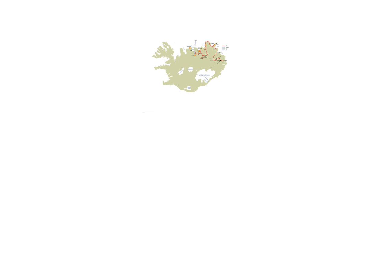
NORTH EAST ICELAND, including MÝVATN – Close to
Nature (5 days)
- starting from Egilsstaðir and ending in Akureyri
The North East of Iceland is considered one of the most
remote parts of the country. It is thinly populated and
covers the open expanse between Akureyri and the East
fjords as well as the seashore in the northeast.
This tour is especially attractive for those who love to
enjoy nature in its purest form. It also includes the famous
lake Mývatn. There you can find hot mud springs and a
variety of volcanic formations. Lake Mývatn is also very
attractive to bird watchers. The small town Húsavík offers
whale watching and Akureyri is a very lovely and vivid
town with many interesting sights.
Tour description
Day 1: Egilsstaðir → Ytra Lón/ Kópasker
Sights: Jökuldalur, Möðrudalsöræfi,
(Sænautasel), Vopnafjörður
Day 2:
Ytra Lón/ Kópasker → Berg
Sights: Ásbyrgi, Dettifoss, Mývatn area
Day 3:
Mývatn area
Day 4:
Berg → Akureyri
Sights: Húsavík, Whale watching, Goðafoss,
(Laufás)
Day 5: Akureyri
Extensions
A: from Akureyri to Siglufjörður, 2 days
B: visit on the northernmost island of Iceland, Grímsey, 1
or 2 days
- enlisted below
Possible Combinations:
- combine this tour with the EAST ICELAND TOUR or the
NORTH WEST ICELAND TOUR
- fly from Akureyri to Reykjavík and combine this tour with
a stay in the capital of Iceland, with day tours starting
from Reykjavík or with the SOUTH WEST OF ICELAND
TOUR
- fly or drive back to Egilsstaðir
Day 1:
If you arrive in Iceland by ferry to Seyðisfjörður, you
need to travel to Egilsstaðir (by bus or car
- for further information on bus schedule to and from
Egilsstaðir contact ph.+354- 470-2300
- coming from Seyðisfjörður drive road no. 93 to
Egilsstaðir
Fjarðarheiði
- highland moor (620 m) that divides the fjord
Seyðisfjörður from the town Egilsstaðir
- the road is steep at both ends and driving conditions can
be very difficult, weather is often rough or foggy up here
- if there is no fog, you have very nice views over the fjord
and the inland district Fljótsdalshérað
Egilsstaðir
- after having crossed Fjarðarheiði you will probably find
better weather conditions here and see a very different
landscape with lowlands, rivers, woods and farmers land
- the town Egilsstaðir is the administrative centre of the
East Fjords
- modern small town, 1700 inhabitants
- schools of higher education, hospital etc.
- all necessary service, supermarket, fuel station,
swimming pool, folk museum, library etc.
- leave Egilsstaðir on road no. 1 driving to the west (in
direction to Akureyri)
- cross the lake Lögurinn
Lögurinn or Lagarfljót
- lake, 2 km wide and 24 km long, 53 m², only 20 m
above sea level but very deep with 111 m
- contains brown or grey glacial water
- a monster is believed to live in the lake, called
Lagarfljótsormurinn (the drake of Lagarfljót), the
descriptions are very similar to those of the monster of
Loch Ness
- largest woodlands of Iceland on the eastern banks of
Lagarfljót
- continue on road no. 1, leaving Lögurinn and the village
Fellabær behind you and crossing the highland plateau
Fljótsdalsheiði until you get to the river Jökulsá á Brú
Jökulsá á Dal or Jökulsá á Brú
- once one of the biggest glacial rivers in Iceland, now
very much changed because of the Kárahnjúkar power
plant
- as all glacial rivers it carried a lot of sand, clay and
stones, 112 tons of this material flooded into the bay of
Héraðsflói every day, now it often is an almost clear fresh
water river
- 1994 a modern bridge was finished, “Jökulsábrú”, 119 m
long, there is a view point at the eastern edge of the
bridge with a good view into the gorge, 70 m wide and 40
m deep
- continue on road no. 1 getting into the valley Jökuldalur
Jökuldalur
- narrow, long valley with low mountains on both sides
- just a few farms, good grassland
- nice waterfalls along the road
- continue on road no. 1
- after leaving the valley Jökuldalur you could travel to the
Sænautasel, to do so you need to leave road no. 1,
turning left and driving road no. 907, follow the signs, it is
not far from the main road

Sænautasel
- former farm, inhabited until the 1940s
- now open to visitors during the summer season
- during the19th century Icelandic farmers settled in this
area in difficult conditions
- after the volcanic eruption in Askja 1874 vast farmlands
were destroyed and many people emigrated to Canada
and the USA, a few farmers returned and took up with
difficult conditions again
- if you want to learn about the life of these people, you
can read a novel by Halldór Laxness, engl. Independent
people, dt. Sein eigener Herr, ísl. Sjálfstætt fólk
- return to road. no. 1
- continue on road no. 1 until you get to road no. 85; turn
right to get to Vopnafjörður
Vopnafjörður
- nice small Village (pop. 500), former important trading
post
- very good natural harbor
- occupation: trading, fishing, fish-processing, farming
- from now on, you will drive along the coast side, a
landscape very different from the interior
- drive road no. 85 crossing the highland moor
Sandvíkurheiði, heading for Þórshöfn
- at Skeggjastaðir you could visit the church, built 1845
- not far from Skeggjastaðir you can see the rock Stapi
rising straight out of the sea
Þórshöfn
- small village, pop. 390, situated at the fjord Þistilsfjörður
- occupation: fishing, fish-processing, trading, good harbor
- from Þórshöfn it is not far to Ytra Lón Hostel (14 km),
drive road no. 869 to get there
- for further information on Ytra Lón Hostel, Langanes, 681
Þórshöfn, ph. +354 468 1242 / 854 3797.
- accommodation is recommended at Ytra Lón Hostel or
Kópasker Hostel
- to get to Kópasker Hostel continue driving on road no. 85
Þistilsfjörður
- fjord or bay between the peninsula Langanes and the
plain highlands of Melrakkaslétta
- a landscape with low hills and valleys with many rivers
running towards the sea
- former an area with several farms on the moors farther
inland
Raufarhöfn
- northernmost village in Iceland, pop. today 340, situated
on the east of the plain Melrakkaslétta
- church designed by the most influential Icelandic
architect, Guðjón Samúelsson
- in the 50’s, during the so called “herring years”, the
harbor underwent extensive improvements; piers were
build to make it possible to land great amounts of herring
- during the “herring adventure” thousands of people
came to Raufarhöfn to help landing, salting and processing
the herring
Melrakkaslétta
- peninsula between Öxarfjörður and Þistilsfjörður
- all flat low land with a lot of lakes and tarns, former
farming area, today mostly abandoned
- eider duck and seal colonies along the coast
- here you are just a bit outside the Arctic Circle
Kópasker
- small village in the fjord Öxarfjörður, pop. 140, harbor
since 1879, pier for oceangoing ships
- In 1976, the epicenter of a very severe earthquake was
out in the fjord Öxarfjörður; the earthquake caused
damage in the village and the harbor.
- accommodation is recommended at Kópasker Hostel
- for further information on Kópasker Hostel, Akurgerði 7,
670 Kópasker – ph.+354-4652314 / 8612314
(Distances: Egilsstaðir – Möðrudalsöræfi 83 km,
Möðrudalsöræfi – Þórshöfn 123 km, Þórshöfn – Kópasker
83 km)
Day 2:
- if you stayed at Ytra Lón drive back to Þórshöfn and
follow the description above to travel to Kópasker
- from Kópasker drive road no. 85 to the south until you
reach Ásbyrgi
Ásbyrgi
- U-shaped valley, surrounded by dark cliffs up to 90 m
high
- Legend has it that this is the footprint of the horse
Sleipnir. It had eight legs and was the horse of the Norse
god Odin.
- Geologists think that Ásbyrgi was shaped by enormous
glacier floods coming underneath the glacier Vatnajökull.
- protected area, long and short walking and hiking trails,
information on nature history of the area provided in
brochures and on information tablets
- small romantic lake “Botnstjörn”, home to the lovely
green-winged teal (duck)
- service, shop, cafeteria just outside the area, near by the
road
- coming from Ásbyrgi drive a short spot back on road no.
85, cross the bridge over the river Jökulsá á fjöllum and
turn right
- drive road no. 864 to get to Dettifoss
- please have in mind that not all vehicles are suitable to
drive on highland roads!
- road no. 864 is closed during the winter season and early
summer if conditions are very bad
- please always get information on road and weather
conditions before driving highland roads contact ph.+354-
522-1000
Dettifoss
- one of the most impressive waterfalls in Iceland and
claimed to be the most powerful waterfall in Europe
- although just 45 m high it dispatches 500 m3 water per
second, since this water comes from a glacier it is of dark
color
- walk from parking to the waterfall takes at least 20
minutes, please be careful, and do not step out of the
marked trails

- continue on road no. 864 (heading south) until you reach
road no. 1
- turn right and drive road no. 1 in direction to lake
Mývatn
- when you get to the Mývatn area you can choose
between many interesting sights (see below) as well as
many possibilities for hiking and bird watching
- it is recommended to stay two nights at Berg Hostel and
come back to the Mývatn area the next day
- from lake Mývatn drive road no. 87 to the north, when
you reach road no. 85 turn left and after a short while
right onto road no. 852 to find Berg
- for further information on Berg Hostel, Sandi,Aðaldal,
641 Húsavík –ph. +354-464-3777
(Distances: Kópasker – Ásbyrgi 37 km, Ásbyrgi – Dettifoss
30 km, Dettifoss – Mývatn 70 km, Mývatn – Berg 59 km)
Day 3:
- drive back to the Mývatn area
Mývatn
- beautiful shallow lake in a region of volcanic activity and
geothermal heat
- during the summer a paradise for ducks and other birds,
average number of 50000 pairs of ducks of 15 species
- very good trout fishing
- extremely beautiful surrounding area, covered with lava
and growth
- interesting geological phenomena like pseudo craters,
lava caves, hot mud and steam springs, canyons etc.
- the name means “lake of the midges”, during the
summer swarms of midges can make life unpleasant here,
but these midges do not bite
- several service stations and restaurants around the lake
- here are some suggestions:
Reykjahlíð
- church and former parsonage, today a small village of
200 inhabitants
- service, restaurant, bank, supermarket, shop
- In the year 1829, the church was threatened by a
volcanic eruption but miraculously the flow of lava stopped
just a few meters from the church. A modern church was
built on the same site in 1972.
Jarðböðin
- very interesting: “Jarðböðin”
- The Mývatn Nature Baths, opened in 2004, are an
outstanding attraction, offering excellent bathing facilities
in an outdoor lagoon whose temperature is 38-40
o
C
- service and information center, cafeteria
- for further information contact ph.+354-464-4411
Námafjall
- mountain south of the pass Námaskarð, former sulfur
mine, the east side of the mountain is all covered by signs
of geothermal heat
- impressive bubbling mud pools, steam vents, hot boiling
springs and fumaroles, distinctive stench of sulfur
everywhere
- there are roped-off paths, please do stick to those paths,
it is extremely dangerous to walk around in this area, the
surface material is fragile and the ground is extremely
hot
Krafla and Víti
- cone-shaped volcano north of Námafjall, but also a
system of fissures
- considerable geothermal heat on the west side of Krafla
- Geothermal Power Station, build in 1984, later extended
- The crater Víti is situated nearby Krafla, its name means
“hell” in Icelandic
Skútustaðir
- famous for a number of pseudo craters, formed by gas
explosions when hot lava flew into the waters, looking like
circular craters or small islands
- protected area, please do not leave the walking paths
and close the gates behind you
- service, shop, cafe
Dimmuborgir
- quite unique recreation area
- valley filled up with bizarre lava formations, caves, holes
and pillars.
- protected area, very sensible birch growth
- several marked walking paths, don not leave the roped
off routes, you can easily get lost in this labyrinth of dark
lava rocks
- newly built service and information centre at the
entrance, cafeteria
-
return to Berg Hostel
Day 4
- from Berg Hostel drive road no. 852 and turn left onto
road no. 85, heading north to get to Húsavík
Húsavík
- nice small town, situated in the bay of Skjálfandafljót,
population 2500
- former fisher town with excellent natural harbor
conditions
- populating now mostly living on service and tourism
- schools, hospital, centre of higher education, banks etc.
- In Húsavík the first Icelandic whale watching tours
started in the early 90’s
- really interesting professional museum and exhibition on
whales and former whaling in Iceland (all the way back to
the Middle Ages), contact ph. +354 414 2800
- Whale watching recommended! There are different
companies offering whale watching in Húsavík. A trip takes
at least 3 hours.
- church, restaurants, cafés, shops, swimming pool, all
services near by the harbor
- hiking trails along the shore, up to Húsavík mountain
(where you will find a surprising hot water bath), around
the small lake Botnsvatn
- hot springs and geothermal heat
- drive road no. 85 back through the valley Aðaldalur
(heading south)
- when you reach road no. 1 turn left and drive a very
short spot to get to Goðafoss waterfall
- best to stop at Fosshóll service station, from here you
can take a walk to the waterfall
Goðafoss
- very impressive waterfall on the river Skjálfandafljót
- Icelandic Sagas tell that back in the year 1000, when the
parliament had decided that Icelanders should adopt the
Christian religion, the law-speaker Þorgeir
Ljósvetningagoði threw his pagan idols into the river. After

that the waterfall was named the “waterfall of the idols” or
gods.
- walking paths, lovely moss and birch growth, please be
careful not destroying it
- cafeteria, shop and service
- drive road no. 1 in direction to Akureyri (to the west)
- when you get to the fjord Eyjaförður you can turn left to
travel to Akureyri or you can choose to turn right (road no.
83) to visit the folk museum Laufás, situated just 13 km
from road no. 1
Laufás
- museum, superb example of a traditional turf farmhouse,
former parsonage
- dating from the late 19
th
century, timber fronted with
five gable roofs, all made of turf
- church from the 19
th
century next door
- for further information on Laufás museum contact
ph.+354-463-3196/ 895-3172
- drive back onto road no. 1
- continue on road no. 1 until you reach Akureyri
- accommodation recommended at Akureyri Hostel
- for further information on Akureyri Hostel,
Stórholt 1
603 Akureyri – ph.+354-462-3657 / +354-894-4299
(Distances: Berg – Húsavík 21 km, Húsavík – Goðafoss 49
km, Goðafoss – Akureyri 50 km; total: 120 km)
Day 5:
- use the day to explore Akureyri
Akureyri
- so called capital of the North, situated in the narrow fjord
Eyjafjörður
- trading place since 1602, population today 16.000
- interesting sites: botanical garden, modern church by the
architect Guðjón Samúelsson, sculpture “The Outlaw” by
Einar Jónsson, Nonnahús (museum in memory of Jón
Sveinsson, author of children books, for example “Nonni
and Manni”), harbor, folk museum, museum on natural
history
- restaurants, cafés, shops, art galleries etc. in the center
of the town, swimming pool, all year Christmas shop
- tourist information, guided tours by bus, boat and jeep
- airport
- for further information on museums, exhibitions etc.
contact ph.+354-460 1000
From Akureyri you can take a flight to Reykjavík or back to
Egilsstaðir or you can drive back to Egilsstaðir. Of course,
it is also possible to do the tour the other way round,
starting from Akureyri and ending in Egilsstaðir.
- for further information on flight schedules contact
AirIceland ph. +354 570 30 30
Extension A:
- from Akureyri drive north to Siglufjörður, stay there for
one night
Dalvík
- former fishing village on the western shores of the fjord
Eyjaförður, 1400 inhabitants
- from you have nice views on Hrísey island
- magnificent mountain peaks surround the village
- departure point for the ferry to Grímsey
- whale watching, folk museum, swimming pool
Hrísey
- flat island at the mouth of the fjord Eyjafjörður
- reached by ferry from Ársskógarsandur (10 km south of
Dalvík)
- picturesque village with 200 inhabitants
- interesting for bird watchers (arctic tern, eider ducks,
ptarmigans, golden plover), hiking trails
Siglufjörður
- fishing town, 1600 inhabitants
- protected against avalanches by two walls (18 and 14 m
high)
- very interesting Herring Era Museum, Iceland’s largest
maritime museum
- The Boat House recreates the town’s bustling harbor of
the 1950s, with many old fishing boats at the dock. During
the years of the so called “herring adventure”, a gold rush-
like atmosphere settled over the town, leading to
Siglufjördur been dubbed the "Atlantic Klondike"
- for further information on the herring museum contact
ph.+354-467-1604
- accommodation recommended at Siglufjörður Hostel
- for further information on Siglufjörður Hostel,
Aðalgata
10, 580 Siglufjörður – ph.+354-467-1506
Extension B:
- by ferry or flight to Grímsey from Akureyri or Dalvík, 1 or
2 days
- for further information on Grímsey contact ph.+354-467-
3159
Wyszukiwarka
Podobne podstrony:
East iceland Glacier and Fjords 5 or 6 days
West Iceland incl snaefellsnes and the west fjords 7 days
Iceland complete 16 days 2
Around Iceland comfort 10 days
Subir Bhaumik Troubled Periphery, The Crisis of India s North East (2009)
Cycle 1 North East Cycle route
Iceland Grand Tour 14 days
West and northwest Iceland excl west fjords 6 days
Iceland on the Ring Road 7 days
Jakobsson, Food and the North Icelandic Identity
02 VIC 10 Days Cumulative A D O Nieznany (2)
Islam in East Europe
50 Common Birds An Illistrated Guide to 50 of the Most Common North American Birds
k 7 days
True North Scraps TOU
African Filmmaking North and South of the Sahara
Maps Of The World Middle East
NORTH AMERICAN STRATIGRAPHIC CODE
więcej podobnych podstron