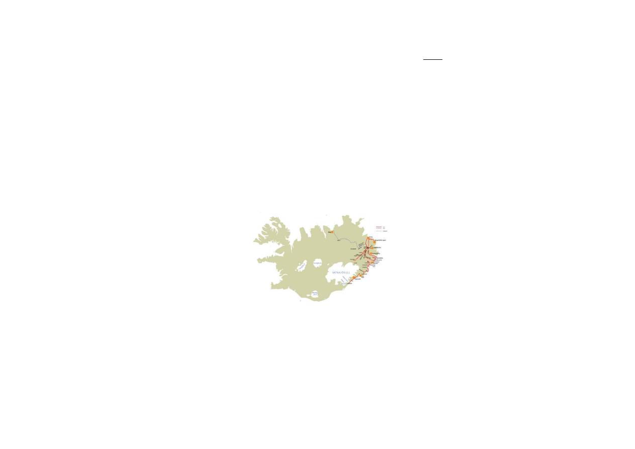
EAST ICELAND – Glaciers and Fjords (5 or 6 days)
- starts and ends at Seyðisfjörður or Egilsstaðir in East
Iceland
- the ferry Norröna arrives at Seyðisfjörður, if you have
your own car, you can start your travel from Seyðisfjörður,
if you need to get a rented car, you can travel by bus to
Egilsstaðir and get it there
- for further information on bus schedule to and from
Egilsstaðir contact ph. +354 472-1551
Typical for East Iceland are the deep and narrow fjords
with its small villages dotted right between high mountains
and the wild ocean. Although farmers settled the eastern
parts of Iceland very early, the “big boom” in this part of
Iceland happened not before the late 19
th
and early 20
th
century when the fishing industry took off, mostly under
Norwegian influence. Due to the needs of fishery and fish
processing the coastal communities grew very rapidly.
Today people in this area live on fishing, modern industry,
service, tourism and farming.
The southeastern parts of the region are dominated by the
largest glacier of Iceland and Europe, Vatnajökull, which
formed the landscape here during thousands of years and
still does. Though the northeastern parts of the region are
far away from Vatnajökull, it still has its impact there due
to big glacial rivers that find their way across the highlands
to the north.
Tour description
1. Day: Seyðisfjörður (via Egilsstaðir) → Berunes
Sights: Fáskrúðsfjörður, Stöðvarfjörður,
Djúpivogur, Papey
2. Day: Berunes → Vagnsstaðir/Höfn
Sights: Vatnajökull, Jökulsárlón
3. Day: Vagnsstaðir/Höfn → Húsey
Sights: Lagarfljót, Valþjófsstaður, (Kárahnjúkar),
Skríðuklaustur, Hengifoss
4. Day: Húsey → Borgarfjörður eystri
Sights: Borgarfjörður eystri
5. Day: Borgarfjörður eystri →
Reyðarfjörður/Seyðisfjörður
Sights: Egilsstaðir, Reyðarfjörður, Seyðisfjörður
Extensions:
A. Mývatn area for 1 or 2 days
Possible combinations:
- combine the EAST ICELAND tour with the SOUTH COAST
ADVENTURE or part of it
- take a flight from Egilsstaðir to Reykjavík to experience
the capital and explore the surroundings
- combine the EAST ICELAND tour with the NORTH EAST
ICELAND tour including Mývatn area
Day 1:
- coming from Seyðisfjörður drive road no. 93 to
Egilsstaðir
Fjarðarheiði
- highland moor (620 m) that divides the fjord
Seyðisfjörður from the town Egilsstaðir
- the road is steep at both ends and driving conditions can
be very difficult, weather is often rough or foggy up here
- if there is no fog, you have very nice views over the fjord
and the inland district Fljótsdalshérað
Egilsstaðir
- after having crossed Fjarðarheiði you will probably find
better weather conditions here and see a very different
landscape with lowlands, rivers, woods and farmers land
- the town Egilsstaðir is the administrative centre of the
East Fjords
- modern small town, 1700 inhabitants
- schools of higher education, hospital etc.
- all necessary service, supermarket, fuel station,
swimming pool, folk museum, library etc.
- leave Egilsstaðir driving road no. 92
Fagridalur
- before reaching the fjord Reyðarfjörður you will drive
through the highland valley Fagridalur (“the beautiful
valley”)
- when you get to Reyðarfjörður turn right (not into town),
now you can choose if you want to drive through the new
tunnel or around the fjord (road no. 96)
Fáskrúðsfjörður
- narrow fjord and fisher village
- there was a lot of French influence here in earlier
centuries because French fishermen had their consulate,
hospital and cemetery in Fáskrúðsfjörður
- one weekend every summer people celebrate the French
Festival (Franskir dagar)
- there is also an exhibition on the French influence in
Iceland
- when you come out of the tunnel you will find a small
parking lot in a very nice surrounding, inviting for a short
walk

- continue on road no. 96
Stöðvarfjörður
- small fjord, former fisher village
- today famous for the “stone collection” of Petra
Steinsdóttir (Steinasafn)
- Steinasafn is an impressive private collection of stones.
Petra decided early in her youth to collect rocks from the
East Fjords, now these rocks have taken over the home
and very lovely garden owned by Petra – worth a visit,
have a chat with family members and enjoy the rocks and
things in house and garden
- continue on road no. 1, passing the bay Breiðdalsvík
Berufjörður
- very picturesque narrow but long fjord, no harbor or
fisher village but several farms
- many possibilities to stop and explore the surroundings
by foot
- accommodation is recommended at Berunes Hostel
- for further information on Berunes Hostel, Berufjörður
765 Djúpivogur – ph.+354-478-8988 / +354-869-7227
- you could use the rest of the day to go to Djúpivogur and
get later back to Berufjörður
Djúpivogur
- beautiful little village centered around the harbor, the
most southern of the East Fjords
- boat trips to the island Papey
- nice walks and bird watching possibilities, also an
exhibition on bird life in Iceland
- museum Langabúð, wooden warehouse building from the
18
th
century, nice café
- swimming pool, supermarket, bank etc.
- drive back to Berunes in Berufjörður
(Distances: Seyðisfjörður-Egilsstaðir 27 km, Egilsstaðir-
Stöðvarfjörður 65 km, Stöðvarfjörður-Berunes 42 km,
Berunes-Djúpivogur-Berunes 80 km; total: 214 km)
Day 2:
- drive road no. 1 heading south, pass Djúpivogur
- drive through the fjords Hamarsjförður and Álftafjörður
- now you are getting into a very different landscape,
leaving the East Fjords behind
- the glacier Vatnajökull dominates the southeastern parts
- in the glacial river valley Lón you will cross the first
glacial river (Jökulsá í Lóni) and possibly you can get a
glimpse on one of the glaciers up in the mountains
- Before you drive through the tunnel, you can turn right
and drive up to the mountain pass Almannakarð. With a
little luck, you can experience an astonishing view on the
icy vastness of Vatnajökull. Maybe you can see the highest
point of Iceland, Hvannadalshnúkur (2.110 m) in the
southern part of Vatnajökull. On a flat peninsula right
below your point of view, you can see the small town Höfn.
There are panorama maps explaining the view.
- drive back and through the tunnel, continue on road no.
1
- there are many viewpoints along the road where you can
stop and take pictures, be careful not to disturb the traffic
Vatnajökull
- largest glacier in Iceland, 8.200 km², up to 900 m thick
- underneath the glacier is one of the most powerful
geothermal areas of the world and many active volcanoes
- the highest point of Iceland is Hvannadalshnúkur (2110
m) in the southern parts of Vatnajökull is called
Öræfajökull
- many glacier tongues jut out of Vatnajökull, all have their
own names and different shapes
- continue driving road no. 1 until you get to the highlight
of the day: Jökulsárlón
Breiðamerkurjökull and Jökulsárlón
- broad glacier tongue that once reached the ocean but
started to retreat during the early 20
th
century
- today between glacier and coast line there is a deep
glacial lagoon: Jökulsárlón
- here we have the lowest point of Iceland
- often icebergs floating on the water before melting down
cover the lagoon
- it is a must to stop at Jökulsárlón, take a walk, make
photos and last but not least book a guided boat trip on
the lagoon – a real highlight of your Iceland vacation, take
your time!
- colony of the Arctic tern, seals, other birds
- guided tours, cafeteria, souvenir shop etc. at Jökulsárlón,
contact ph.+354-478-2122
- on your way back you could stop at Hali
Hali
- cultural heritage exhibition on novelist Þórbergur
Þórðarson (1888-1974)
- very nice exhibition showing the life of Þórbergur as well
as living conditions here in Öræfasveit during the late 19
th
and early 20
th
century
- you can see a building looking like an oversized
bookshelf containing the works of Þórbergur from the ring
road
- Öræfasveit was the most isolated district of Iceland until
the 1960’s, it was surrounded by the glacier to the north,
the sea to the south and dangerous unabridged glacial
rivers to the west and east
- cafeteria, nice walks and views
- accommodation is recommended at Vagnsstaðir Hostel or
Höfn Hostel
- you need to drive back on road no. 1, heading east
- for further information on Vagnsstaðir Hostel, Suðursveit,
A-Skaftafellssýsla, 781 Höfn – ph.+ 354-478-1048
- for further information on Höfn Hostel, Hafnarbraut 8
780 Höfn – ph.+354-478-1736
- staying in the area you can book guided jeep excursions
on Vatnajökull glacier during day and evening hours
Höfn
- small town at the south coast of Iceland
- 1800 inhabitants, living on fishing, tourism, service
- all necessary service available including library, new
swimming pool, restaurants, shopping centre, tourist
information etc.
- very interesting glacier exhibition, really worth a visit

- nice walk on Nes, an area near the harbor, great view on
the Vatnajökull, memorial for fishermen, bird colonies,
especially the arctic tern
- one weekend during the summer season, people
celebrate the Lobster Festival
(Distances: Berunes-Almannaskarð 132 km,
Almannaskarð-Jökulsárlón 83 km, Jökulsárlón-
Vagnsstaðir/Höfn 28/51 km; total 243/266 km)
Day 3:
- coming from Vagnsstaðir or Höfn drive road no. 1 to the
east
- when you get to Breiðdalsvík you can choose if you want
to drive along the coastline (road no. 96) as you did the
day before or if you want to drive road no. 1 crossing the
highland plateau Breiðdalsheiði
Breiðdalsheiði
- highland plateau and mountain road across the moor
between Skriðdalur and Breiðdalur
- up to 420 m high, very impressive landscape, very
different from the fjords
- with a little luck, you can spot reindeer
- little lake, Heiðarvatn, nearby the road
- be careful in bad weather conditions
- drive road no. 1 until you reach lake Lögurinn or
Lagarfljót
- turn left onto road no. 93 to drive along the lake
Lögurinn or Lagarfljót
- lake, 2 km wide and 24 km long, 53 m², only 20 m
above sea level but very deep with 111 m
- contains brown or grey glacial water
- a monster is believed to live in the lake, called
Lagarfljótsormurinn (the drake of Lagarfljót), the
descriptions are very similar to those of the monster of
Loch Ness
- largest woodlands of Iceland on the eastern banks of
Lagarfljót
Hallormsstaðarskógur
- most important forest in Iceland
- since the early 20
th
century the Icelandic Forrest
Commission made considerable effort to preserve
woodlands and plant new trees
- nice walking paths through the forests of Hallormsstaður
with labeled collection of trees
- also worth a visit is Atlavík, a small bay of Lagarfljót
- continue driving road no. 93 and 933, cross the lake and
turn left to get to Valþjófsstaðir
Valþjófsstaðir
- former manor farm, church and parsonage
- today there is a new church with a replica of the wooden
carved church door from medieval times, the original door
is now owned by the National Museum in Reykjavík
- turn back on road no. 931, heading north
- not far from Valþjófsstaður you can find the community
centre Végarður with the new information centre on
Kárahnjúkar power plant, worth a visit to learn about this
biggest power plant system in Iceland as well as its impact
on nature and society
Végarður Visitor Centre, Kárahnjúkar
- for further information contact ph.+354 515 9000
- from here you could also drive up to Kárahnjúkar, but it
is a 1,5 hour drive and you need to get back the same
way, the landscape in this part of the highlands is very
impressive, if weather conditions are good you can see
Snæfell and other mountains
- coming from Végarður or Valþjófsstaður continue driving
road no. 933 and 931
- heading north along the lake you get to Skríðuklaustur
Skríðuklaustur
- monastery during the middle ages until the16
th
century
- ongoing archeological excavation
- in the 1930s, the famous novelist Gunnar Gunnarsson
built his stone house here
- interesting exhibition on the life and work of Gunnar
Gunnarsson (1889-1975)
- guided tours with a lot of information on the novelist, the
house and the archeological excavations
- nice café with local dishes and cakes
- continue on road no. 931
Hengifoss
- very high (118 m) and beautiful waterfall partly to be
seen from the parking lot
- hiking to the waterfall takes about 2 hours, difficult path,
can be muddy and slippery, you need to wade through
several creeks
- the waterfall Litlanesfoss is further downstream, nicely
set in basalt columns
- continue on road no. 931 until you reach the small town
Fellabær
- turn left onto road no. 1, drive road no. 1 until you get to
the river Jökulsá á Dal
Jökulsá á Dal or Jökulsá á Brú
- once one of the biggest glacial rivers in Iceland, now very
much changed because of Kárahnjúkar power plant
- as all glacial rivers it carried a lot of sand, clay and
stones, 112 tons of this material flooded into the bay of
Héraðsflói every day, now it often is an almost clear fresh
water river
- 1994 a modern bridge was finished, “Jökulsábrú”, 119 m
long, there is a view point at the eastern edge of the
bridge with a good view into the gorge, 70 m wide and 40
m deep
- when reaching the bridge turn right onto road no. 925
and continue on road no. 926 to Húsey
- accommodation is recommended at Húsey Hostel
- for further Information on Húsey Hostel,
Fljótdalshérað
701 Egilsstadir – ph.+354-471-3010 /847-8229
Attn.: This day tour is very long and there are many
interesting sights. You could shorten it by driving to
Egilsstaðir and Húsey without driving round the lake
Lagarfljót. You can also change it into a two-day tour by
staying at Seyðisfjörður or Reyðarfjörður Hostel before
driving round Lagarfljót the next day and taking more time
there. Thus, you would prolong your trip from five to six
days.

(Distances: Höfn-Breiðdalsvík 162 km, Breiðdalsvík-
Lagarfljót 81 km, Lagarfljót-Fellabær without Kárahnjúkar
71 km, Fellabær-Húsey 49 km; total: 363 km)
Day 4:
- from Húsey drive road no. 926 to the south, turn left
onto road no. 927, drive in direction to Kirkjubær (to the
north), at Lagarfoss cross the river
Lagarfoss
- waterfall in the river Lagarfljót, devided in two parts
- hydro power station
- bridge over the dam of the power station
- turn left onto road no. 94 (Borgarfjarðarvegur), the road
not Borgjarfjörður eystri
Borgarfjörður eystri
- one of the most remote places in Iceland, to get to the
fjord you have to drive over a mountain pass with steep
roads and serpentines, there are several viewpoints along
this road
- Borgarfjörður eystri is a short, wide fjord, very grassy
and fertile; magnificent colorful mountains of rhyolite and
basalt.
- the village Bakkagerði is situated in the fjord, population
150, living on fishing and service
- The famous Icelandic painter Jóhannes Kjarval (1885-
1972) was born in Borgarfjörður eystri, you can find an
exhibition on him in the community center, also there is an
altarpiece painted Kjarval in the local church.
- many hiking trails, good written information at the spots
- at the harbor a little outside the village there are
excellent bird watching conditions, especially puffins
- near the center of Bakkagerði there is a picturesque
rock, called the rock of elves, Álfaborg, it is believed that
elves live in this rock, walking path around it
- accommodation is recommended at Borgarfjörður
eystri Hostel
- for further information on Borgarfjörður Eystri Hostel,
Ásbyrgi, 720 Borgarfjörður Eystri – ph.+354-472-9962 /
472-9920 / 866-3913
(Distances: Húsey-Lagarfoss 29 km, Lagarfoss-Bakkagerði
43 km; total: 72 km)
Day 5:
- coming from Borgarfjörður eystri drive back over the
mountain ridge and on road no. 94 to the south until you
get to Egilsstaðir
- you could spend some time in Egilsstaðir, go to the
swimming pool or visit the local folk museum
- travel to Seyðisfjörður Hostel or Reyðarfjörður Hostel
were accommodation is recommended
Seyðisfjörður
- town at the head of a narrow curving fjord of the same
name, population about 800
- The town developed rapidly during the late 19
th
and early
20
th
century.
- Trading and fishing started in the 19th century when the
Norwegian Otto Wathne opened a herring fishing and
processing station, later the Icelandic population learned
from the Norwegians how to exploit the herring.
- good harbor, the ferry Norröna from Denmark and
Norway lands in Seyðisfjörður.
- attractive harbor side with traditional Norwegian-
Icelandic timber houses
- Seyðisfjörður was a US naval base during World War II
- hiking trails
- accommodation recommended at “Hafalda” Seyðisfjörður
Hostel
- for further information on Seyðisfjörður Hostel,
Ránargata 9, 710 Seyðisfjörður – ph.+354-472-1410 /
891-7010
Reyðarfjörður
- town in the fjord Reyðarfjörður
- expanded very much during the last years because of the
new built aluminum smelter a few km away from the town
- Reyðarfjörður was built up as a naval US base during
World War II; see the Icelandic Wartime Museum
(Stríðsárasafnið)
- from here you could also visit the towns Eskifjörður and
Neskaupstaður, driving there is a unique experience
because of the high mountain passes (630 m) with
astonishing views over the fjords and the ocean
- accommodation recommended at Reyðarfjörður Hostel
- for further information on Reyðarfjörður Hostel,
Vallargerð 9 and 14, 730 Reyðarfjörður – ph.+354-892-
0336
(Distances: Borgjarfjörður eystri-Egilsstaðir 69 km,
Egilsstaðir-Seyðisfjörður 27 km, Egilsstaðir-Reyðarfjörður
31 km)
Extension A: Mývatn area
- from Egilsstaðir drive road no. 1 heading west, crossing
the river Jökulsá á Dal
- drive through the valley Jökuldalur and continue on road
no. 1 until you reach the Mývatn area
- for details on Mývatn see the NORTH EAST ICELAND tour
- explore the Mývatn area for 1 or 2 days
- best to do so after having stayed at Húsey Hostel and
before going to Borgarfjörður eystri (see day 4)
- accommodation recommended at Berg Hostel, for further
information on Berg Hostel, Sandi, Aðaldal, 641 Húsavík –
ph. +354-464-3777
Wyszukiwarka
Podobne podstrony:
West and northwest Iceland excl west fjords 6 days
North East Iceland incl Myvatn 5 days
35th Lecture In Poker, You Can Stay The Same And Suffer Or Adjust And Prosper
A Companion to Old Norse Icelandic Literature and Culture review
Said and Unsaid or The Value
Iceland on the Ring Road 7 days
C and C in Five Days
U2 Love And Peace Or Else
Dehydration of Carrots by a Combination of Freeze Drying, Microwave Heating and Air or Vacuum Drying
West Iceland incl snaefellsnes and the west fjords 7 days
There are many languages and cultures which are disappearing or have already disappeared from the wo
PRELUDES OR TOCCATAS AND FUGUES
ip lpec bramki AND,OR,NAND,NOR,NOT
Plane, train or bicycle Which is the?st way to travel and why
Whales are black or blue and white, Pliki tekstowe
home dzine co za How to colour or tint cement and concrete
Egelhoff Tom C How To Market, Advertise, And Promote Your Business Or Service In Your Own Backyard
!!!2006 biofeedback and or sphincter excerises for tr of fecal incont rev Cochr
więcej podobnych podstron