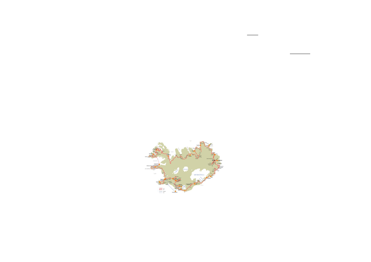
ICELAND COMPLETE - 16 days
(including Snæfellsnes peninsula, West Fjords and
Reykjanes peninsula)
- starts in the capital Reykjavík and ends in Njarðvik
(Reykjanes peninsula)
The Iceland complete tour covers not only most of the
interesting places along the ring road, it also brings you to
the Snæfellsnes peninsula, to the West Fjords, to remote
parts of the North East and to the Reykjanes peninsula.
On this tour you get a good impression of Icelandic nature
in nearly all its varieties and you can learn a lot about
living conditions in Iceland today and in the old days. You
will be surprised how many different types of landscapes
and other nature phenomena you can see in this country.
Iceland Complete is a circle tour, therefore you can start it
at other places as well, for example in Egilsstaðir or
Akureyri. It goes clockwise around the country, but of
course you can turn it around and travel against the clock.
If you want to extend this tour and make it “really
complete”, you can add a stay at Þórsmörk Hostel or at
Vestmannaeyjar Hostel to it, see details below (Extension
A and B).
Tour description
Day 1:
Reykjavík → Grundarfjörður/
Stykkishólmur
Sights: Snæfellsnes peninsula
Day 2:
Grundarfjörður/ Stykkishólmur →
Bíldudalur
Sights: Breiðafjörður, Látrabjarg,
Hnjótur
Day 3:
Bíldudalur → Korpudalur
Sights: Dynjandi, Hrafnseyri,
Þingeyri
Day 4:
Korpudalur → Broddanes
Sights: Ísafjörður, (Vigur), Reykjanes,
Hólmavík
Day 5:
Broddanes → Akureyri
Sights: Blönduós, Víðimýri, Glaumbær,
Öxnadalur
Day 6:
Akureyri → Berg
Sights: Goðafoss, Mývatn area
Day 7:
Berg → Kópasker/Ytra Lón
Sights: Húsavík, Ásbyrgi, Dettifoss,
Melrakkaslétta
Day 8:
Kópasker/Ytra Lón → Húsey
Sights: Vopnafjörður, Hellisheiði,
Jökulsá
Day 9:
Húsey → Seyðisfjörður/Reyðarfjörður
Sights: Lagarfljót, Hengifoss,
Skríðuklaustur, Valþjófsstaður, Hallormstaðarskógur
Day 10:
Seyðisfjörður/Reyðarfjörður → Höfn
Sights: Stöðvarfjörður, Djúpivogur,
Almannaskarð, Höfn
Day 11:
Höfn/Vagnsstaðir → Hvoll
Sights: Vatnajökull, Jökulsárlón,
Skaftafell, Núpsstaður
Day 12:
Hvoll → Vík/Skógar
Sights: Kirkjugólf,
Kirkjubæjarklaustur, Eldhraun, Fjaðrárgljúfur, Vík
Day 13:
Vík/Skógar → Fljótsdalur
Sights: Sólheimajökull, Skógar folk
museum, Skógafoss, Seljalandsfoss
Day 14 :
Fljotsdalur → Árnes
Sights: Hekla, Búrfellsvirkjun, Stöng,
Þjóðveldisbær, Háifoss, Hjálparfoss
Day 15:
Árnes → Reykjavík
Sights: Gullfoss, Geysir, Laugarvatn,
Þingvellir, Reykjavík
Day 16:
Reykjavík → Njarðvík
Sights: Bessastaðir, Hafnarfjörður,
Kleifarvatn, Krýsuvík, Grindavík, Blue lagoon
Day 1:
- from Reykjavík drive road no. 1 (ring road) to the north
- pass the small town Mosfellsbær
- continue until you reach the fjord Hvalfjörður
- drive through the tunnel, please notice: you need to pay
obligate toll (1000,- ISK)
Hvalfjarðargöng
- tunnel underneath the fjord Hvalfjörður
- built 1996-1998, 5.6 km long, 165 m deep (measured
from sea level)
- right after leaving the tunnel turn right and drive road
no. 1 to reach Borgarnes
Borgarnes
- small town, 2.500 inhabitants, living on industry and
services
- restaurant, services, shopping center, bank, hospitel etc.
- one of the sites of the the famous Saga of Egill
Skallagrímsson
- interesting botanical garden with a relief sculpture of
Egill Skallagrímsson
- leave Borgarnes on road no. 54 (Snæfellsnesvegur)
towards the peninsula Snæfellsnes
- possible stop at Borg á Mýrum, famous church and
parsonage with sculpture Sonatorrek (“Irretrievable Loss
of Sons”) by Ásmundur Sveinsson, based on a poem from
Egils saga
Eldborg
- volcanic crater, 100 m above sea level, 200 m in
diameter, 50 m deep in the middle of a lava field called
Eldborgarhraun
- walking path (30 min. walk) from road no. 1.
- protected area
- drive road no. 54, near Búðir go straight onto road no.
574 (Útnesvegur)
Búðahraun
- lava field on the south shore of Snæfellsnes peninsula
- lovely church from 19th century at Búðir
- yellow sand beach, rare in Iceland, with black lava
Arnarstapi and Hellnar
- two former fishing villages

- beautiful and striking coast line, interesting rock
formations, basalt columns, gorges, caves, sea bird
colonies
- in Arnarstapi you will see the stone monument to the
hero Barður Snæfellsás, who protects the area from evil as
the local legend has it
- several marked hiking paths to the caves and sea bird
colonies
- restaurant at Arnarstapi, café at Hellnar
- national park office including interersting exhibition at
Hellnar
- continue on road no. 574
Snæfellsjökull
- The area is dominated by the three peaked volcano and
glacier Snæfellsjökull (1446 m high) which is believed to
be a place of supernatural power.
- One of the most famous volcanoes in Iceland featured in
novels by Jules Verne and Icelandic writer Halldór
Laxness.
- today national park
- several hiking trails
Dritvík
- For centuries one of the busiest fishing-stations, once
inhabiting 600 seasonal workers.
- walking path to the shore (Djúpalónssandur), where
there are four well-known lifting stones which
fishermen
would try their strength at, they had to be able to lift at
least the smaller ones
Rif and Hellissandur
- former important fisher villages
- western most settlements on Snæfellsnes peninsula
- maritime museum and fishermen’s cottages at
Hellissandur
- large colony of the arctic tern between Rif and
Hellissandur
Ólafsvík
- small town (900 inhabitants), good harbor facilities, rich
offshore fishing grounds
- m
useum in a 19th century warehouse
- a
ll necessary services
- continue on road no. 574 and 54 to Grundarfjörður
Grundarfjörður
- fishing and trading center since the 18th century, named
after the fjord Grundarfjörður
- today lovely small town in a great environment,
dominated by the mountain Kirkjufell
- population about 850, living on fishing and fish
processing
- french fishermen built a church and several houses in the
town
- swimming pool, tourist information
- accommodation recommended at Grundarfjörður
Hostel or Stykkishólmur Hostel
- for further information on Grundarfjörður Hostel,
Hliðarvegur 15, 350 Grundarfjörður – ph. +354-895-6533
/ +354-562-6533
- if you are going to stay at Stykkishólmur Hostel continue
on road no. 54 and 58 to get to the town Stykkishólmur
Stykkishólmur
- town with 1230 inhabitants, fishing and trading center,
school, hospital
- for centuries a focal point for settlement in the
Breiðafjörður area
- modern space age looking church, concert hall, art
museum on water “Vatnasjafnið”
- folk museum close to the harbor in the “Norwegian
House”
- super market, great swimming pool
- from here the ferry Baldur goes to Brjánslækur (West
fjords)
- light house near the harbor
- several boat trips with bird and whale watching, tourist
information centre
- accommodation is recommended at Stykkishólmur
Hostel
- for further information on Stykkishólmur Hostel,
Höfðagata 1, 340 Stykkishólmur – ph. +354-438-1417 /
+354-861-2517
(Distances: Reykjavík-Borgarnes 63 km, Borgarnes-Búðir
102 km, Búðir-Grundarfjörður 89 km, Grundarfjörður-
Stykkishólmur 45 km; total: 254/299 km)
Day 2:
- if you stayed at Grundarfjörður Hostel, drive
road no. 54
and 58 to get to Stykkishólmur
- take the ferry Baldur to Brjánslækur (West Fjords)
- passage takes 3 hours; arrival at 12 o’clock
- for cars you need to book in advance
- for further information on the ferry contact
Sæferðir ph. 433-5422
- when you get to Brjánslækur drive road no. 62 in
direction to the west (Barðaströnd)
- drive the mountain road Kleifaheiði (404 m high) in
direction to Patreksfjörður
- when you reach the fjord turn left onto road no. 612
- please have in mind that there is no gas station on the
way to Látrabjarg
- be careful on mountain and gravel roads, pay attention
to weather conditions
- pass Breiðavík and continue until you get to Látrabjarg,
the road is very rough and climbs up over a plateau and
than steeply down to the coastline
Bjargtangar and Látrabjarg
- Bjargtangar is the westernmost point of Europe, there is
a light house
- Látrarbjarg cliffs rise up to 414 m above sea level, the
cliffs are 12 km long
- sea bird colonies (puffins, guillemot, razorbills, fulmars,
kittiwakes)
- a foot path along the top of the cliff offers great views,
you can get really near the birds, but please be careful not
to fall off the cliff or to disturb the birds
-
many shipwrecks have occurred in the rough sea here
- travel the same way back
Hnjótur
- farm, café and interesting folk and aviation museum,
initiated by the local Egill Ólafsson
- memorial to British seamen
- you can watch a film on sea rescue operations that
occurred in 1947 and 1948 when the British trawlers
Dhoon and Sargon wrecked during severe snow storms
- drive road no. 616, when you get to the the crossroads
in the fjord Patreksfjörður turn left onto road no. 62,
heading for the town Patreksfjörður
Patreksfjörður
- small town located on the shore of the southernmost of
all Westfjords, named after the fjord
- main industry fishing and fishprocessing, population
about 700
- memorial to the victims of avalanches and to British
seamen from Aberdeen, Hull and Grimsby
- drive road no. 63, pass the fjord Tálknafjörður and drive
over the mountain pass Hálfdan (525 m), heading for
Bíldudalur
Bíldudalur

- small village (pop. 260), once one of the most important
fishing stations in Iceland
- main occupation today fishing and fish processing
- monument for drowned seamen of the village
- museum “Melódíur minninganna” (Melody Memory Lane),
a small private museum dedicated to Icelandic popular
music
- accommodation recommended at Bíldudalur Hostel
- for further information on Bíldudalur Hostel,
Hafnarbraut
2, 465 Bíldudalur – ph. +354-456-2100, +354-860-2100
(Distances: Brjánslækur-Patreksfjörður 42 km,
Patreksjförður-Látrabjarg-Patreksjförður village 124 km,
Patreksfjörður-Bíldudalur 27 km; total: 193 km)
Day 3:
- drive road no. 63 along the coastline of Suðurfirðir
Suðurfirðir
- collective name of the fjords of the southern branch of
Arnarfjörður, Fossjörður, Reykjafjörður, Trostansfjörður
and Geirþjófsförður
- typical landscape of the West fjords: high mountain
plateaus and deep fjords, very little of flat land, hardly any
space for agriculture, difficult roads
- near Hornatær turn left onto road no. 60
(Vestfjarðavegur) and drive over the plateau
Dynjandisheiði (500 m high) to reach the waterfall
Dynjandi
Dynjandi
- one of the most beautiful and impressive waterfalls in
Iceland
- The water falls in many cascades down from 100 m
height, forming a huge triangular.
- There is a walking path along the waterfall; it takes at
least 1 hour to climb up the hillside. Take your time, it is a
wonderful place. There are facilities at the camping site.
Nice place for picnic.
- drive road no. 60 to Hrafnseyri
Hrafnseyri
- birthplace of Jón Sigurðsson (1811-1879), called the
president, one of the leaders of the Icelandic
independence struggle during the 19th century
- replica of a turf farm house and museum dedicated to
Jón Sigurðsson, also a nice cafe
- his birthday, June 17
th
, is the national holiday; on June
17th 1944 the Republic of Iceland was established
- drive road no. 60 over the mountain plateau
Hrafnseyrarheiði (552 m) to reach Þingeyri
Þingeyri
- village with a population of 380
- oldest trading place in the West fjords
- one of Iceland’s oldest houses is in Þingeyri, a
warehouse dating back to the 18th century
- spectacular nature surrounds Þingeyri, high mountains
and beautiful valleys
- continue on road no. 60 along the fjord Dýrafjörður
Dýrafjörður
- largest fjord in this county, about 39 km long but narrow
- two mountains, Sandfell and Mýrafell, on both sides of
the mouth of the fjord
- continue on road no. 60 over the mountain plateau
Gemlufallsheiði to reach the bottom of the fjord
Önundarfjörður
- turn right onto road no. 627, heading for Korpudalur
Hostel (Kirkjuból)
- for further information on Korpudalur Hostel, Korpudalur
Kirkjubol, 425 Flateyri – ph. +354-456-7808
(Distances: Bíldudalur-Dynjandi 60 km, Dynjandi-
Korpudalur 54 km; total: 104 km)
Day 4:
- from Korpudalur Hostel drive road no. 627 and turn right
onto road no. 60, heading for Ísafjörður
Ísafjörður
- so called capital of the West fjords, largest settlement in
the area, pop. about 3000
- living on fishing, trade, administration and tourism
- situated in the fjord Skutulsfjörður which is a part of the
Ísafjarðardjúp
- all necessary service, banks, shops, hospital, schools
- institutions for higher education
- the oldest part of the town is called Neðstikaupstaður;
here you find four of the oldest houses in Iceland, built in
the 18th century
- very interesting maritime and folk museum in
Neðstikaupstaður
- for further information see http://nedsti.is/index.asp
- not far from Neðstikaupstaður at the harbor, you can
find options for boat trips to the romantic islands Vigur
and Æðey
- drive road no. 61 along the several fjords of
Ísafjarðardjúp
Ísafjarðardjúp
- largest of the West fjords, a number of smaller fjords
open into it: Skutulsfjörður, Álftafjörður, Seyðisfjörður,
Hestfjörður, Skötufjörður, Mjóifjörður, and Ísafjörður
Súðavík
- small village situated in the fjord Álftafjörður.
- founded in the late 19th century when Norwegians
started to run a whaling station at the place
- On January 16
th
1995 an avalanche fell on Súðavík,
killing 14 people and destroying 22 houses.
- drive road no. 61 along the coastline, when reach the
fjord Mjóifjörður driver over the bridge to get the remote
peninsula Reykjanes
Reykjanes
- narrow peninsula between the fjord Ísafjörður and the
fjord Reykjafjörður
- the name means peninsula of steam, which reminds on
the geothermal hot springs in this area.
- In 1934 a district boarding school was build here. Nice
outdoor swimming pool that once belonged to the school.
- hiking trails, bird watching, hot springs near by the shore
- cafeteria that offers simple meals
- from Reykjanes drive road no. 61, heading for Hólmavík
- drive over the highland plateau Steingrímsfjarðarheiði
(440 m high), continue on road no. 61
Hólmavík
- village situated in Steingrímsfjörður, population 400,
living on fishing and fish processing
- interesting church, cafés, shops, handcraft
- quite an interesting history museum with emphasis on
the history of the witch-hunting in 17th century Iceland as
well as various aspects of magic from younger sources
- for further information on the Exhibition of Sorcery &
Witchcraft, contact ph.
+354 451 3525
- accommodation is recommended at Broddanes Hostel
- Broddanes is situated 35 km south of Hólmavík
- drive road no. 61
- for further information on Broddanes Hostel,
Broddanesskóla, 510 Hólmavík – ph. +354 618 1830
(Distances: Korpudalur-Ísafjörður 40 km, Ísafjörður-
Reykjanes ca. 140 km, Reykjanes-Hólmavík 100 km,
Hólmavík-Broddanes 35 km; total ca. 315 km)
Day 5:

- from Broddanes continue on road no. 61, at the bottom
of the fjord Hrútafjörður, turn left onto road no. 1,
continue on road no. 1
Blönduós
- small town, pop. 1000, living on agriculture, transport,
trading
- situated at the mouth of the river Blanda built on both
sides of the river
- very interesting modern church, built in the years 1981-
1985
- all necessary service available, bank, shops, gas station,
restaurant
- nice recreation area on an island in the glacial river
Blanda, worth to stop and go for a walk (you can see it
from the gas station)
- continue on road no. 1, driving through the valley
Langidalur and over the pass Vatnsskarð
Arnarstapi
- coming down the mountain pass Vatnsskarð you should
stop at the memorial for Stephan G. Stephansson and
enjoy the views on the fjord Skagafjörður
- Stephan G. Stephansson (1853-1927) was an Icelandic
farmer and poet who lived in this area before leaving the
country to settle in USA and Canada, he was called the
poet of the Rocky Mountains
- many farmers and poor people from the Skagafjörður
area emigrated to Canada and the USA in the late 19th
and early 20th century, forming the community of the
West-Icelanders in Canada (especially in Manitoba)
- continue on road no. 1
- before getting to Varmahlíð, you can find the church of
Víðimýri to the right of road no. 1
Víðimýrikirkja
- traditional turf church from 1834
- one of the most beautiful turf churches still existing in
Iceland
- very good example of traditional Icelandic architecture
- local guide, leaflets, postcards at the spot
- continue on road no. 1, turn left on to road no. 75,
passing the village Varmahlíð to get to Glaumbær
Glaumbær
- very interesting open air and folk museum, former
parsonage and wealthy farm
- one of the few remaining Icelandic turf farms, oldest
parts of it are from the 18th century
- Beside the turf farm, there are buildings from the 19th
and early 20th century, including a church and a former
school for housekeepers.
- Take your time; there are many things to explore and to
learn about everyday life in Iceland.
- There is a very nice café in a cozy old-fashioned tearoom
where you can get traditional Icelandic cakes and other
local snacks.
- for further information on Glaumbær museum contact
ph.+354-453-6173
- drive back on road no. 75, turn right onto road no. 1,
heading east
Öxnadalur
- very deep and narrow valley, 35 km long
- The rocky mountain ridge Hraundrangi is more than
1000 m high and really impressive, many folk tales are
connected to it.
-Two of the most famous Icelandic poets lived in this
valley: Jónas Hallgrímsson (1807-1845), scientist and
poet, was born at the farm Hraun and Jón Þórláksson
(1744-1819), poet and translator, lived at the farm and
parsonage Ytri-Bægisá.
- continue on road no. 1 until you reach the fjord
Eyjafjörður.
Eyjafjörður
- collective name of the fjord and the narrow, well
cultivated valley (60 km long) toward the head of the fjord
- the river Eyjarfarðará runs through the valley into the
fjord
- the town Akureyri is situated in the fjord Eyjafjörður
Akureyri
- so called capital of the North, situated in the narrow fjord
Eyjafjörður
- trading place since 1602, population today 16.000
- interesting sites: botanical garden, modern church by the
architect Guðjón Samúelsson, sculpture “The Outlaw” by
Einar Jónsson, Nonnahús (museum in memory of Jón
Sveinsson, author of children books, for example “Nonni
and Manni”), harbor, folk museum, museum on natural
history
- restaurants, cafés, shops, art galleries etc. in the center
of the town, swimming pool, all year Christmas shop
- tourist information, guided tours by bus, boat and jeep
- airport
- for further information on museums, exhibitions etc.
contact ph.+354-460-1000
- accommodation recommended at Akureyri Hostel
- for further information on Akureyri Hostel,
Stórholt 1,
603 Akureyri – ph. +354-462-3657 / +354-894-4299
(Distances: Broddanes-Hrútafjörður (bottom) 78 km,
Hrútafjörður (bottom)-Blönduós 85 km, Blönduós-
Glaumbær 57 km, Glaumbær-Akureyri 101 km; total: 321
km)
Day 6:
- from Akureyri drive road no. 1, heading east
Goðafoss
- very impressive waterfall on the river Skjálfandafljót
- Icelandic Sagas tell that back in the year 1000, when the
parliament had decided that Icelanders should adopt the
Christian religion, the law-speaker Þorgeir
Ljósvetningagoði threw his pagan idols into the river. After
that the waterfall was named the “waterfall of the idols” or
gods.
- walking paths, lovely moss and birch growth, please be
careful not destroying it
- cafeteria, shop and service
- continue on road no. 1 to reach the Mývatn area
Mývatn
- beautiful shallow lake in a region of volcanic activity and
geothermal heat
- during the summer a paradise for ducks and other birds,
average number of 50000 pairs of ducks of 15 species
- very good trout fishing
- extremely beautiful surrounding area, covered with lava
and growth
- interesting geological phenomena like pseudo craters,
lava caves, hot mud and steam springs, canyons etc.
- the name means “lake of the midges”, during the
summer swarms of midges can make life unpleasant here,
but these midges do not bite
- several service stations and restaurants around the lake
- here are a few suggestions for spending the day:
Reykjahlíð
- church and former parsonage, today a small village of
200 inhabitants
- service, restaurant, bank, supermarket, shop
- In the year 1829, the church was threatened by a
volcanic eruption but miraculously the flow of lava stopped
just a few meters from the church. A modern church was
built on the same site in 1972.

Jarðböðin
- very interesting: “Jarðböðin”
- The Mývatn Nature Baths, opened in 2004, are an
outstanding attraction, offering excellent bathing facilities
in an outdoor lagoon whose temperature is 38-40
o
C
- service and information center, cafeteria
- for further information contact ph. +354-464-4411
Námafjall
- mountain south of the pass Námaskarð, former sulfur
mine, the east side of the mountain is all covered by signs
of geothermal heat
- impressive bubbling mud pools, steam vents, hot boiling
springs and fumaroles, distinctive stench of sulfur
everywhere
- there are roped-off paths, please do stick to those paths,
it is extremely dangerous to walk around in this area, the
surface material is fragile and the ground is extremely
hot
Krafla and Víti
- cone-shaped volcano north of Námafjall, but also a
system of fissures
- considerable geothermal heat on the west side of Krafla
- Geothermal Power Station, build in 1984, later extended
- The crater Víti is situated nearby Krafla, its name means
“hell” in Icelandic
Skútustaðir
- famous for a number of pseudo craters, formed by gas
explosions when hot lava flew into the waters, looking like
circular craters or small islands
- protected area, please do not leave the walking paths
and close the gates behind you
- service, shop, café
Dimmuborgir
- quite unique recreation area
- valley filled up with bizarre lava formations, caves, holes
and pillars.
- protected area, very sensible birch growth
- several marked walking paths, don not leave the roped
off routes, you can easily get lost in this labyrinth of dark
lava rocks
- newly built service and information centre at the
entrance, cafeteria
- accommodation recommended at Berg Hostel
- from lake Mývatn drive road no. 87 to the north, when
you reach road no. 85 turn left and after a short while
right onto road no. 852 to find Berg
- for further information on Berg Hostel, Sandi, Aðaldal,
641 Húsavík – ph. 354-464-3777
(Distances: Akureyri – Goðafoss 50 km, Goðafoss –
Mývatn (Reykjahlíð) 53 km, Mývatn (Reykjahlíð) – Berg
Hostel 47 km; total depends on what sights you choose at
Mývatn)
Day 7:
- from Berg Hostel drive road no. 852 and turn left onto
road no. 85, drive north to get to Húsavík
Húsavík
- nice small town, situated in the bay of Skjálfandafljót,
population 2500
- former fisher town with excellent natural harbor
conditions
- populating now mostly living on service and tourism
- schools, hospital, centre of higher education, banks etc.
- In Húsavík the first Icelandic whale watching tours
started in the early 90’s
- really interesting professional museum and exhibition on
whales and former whaling in Iceland (all the way back to
the Middle Ages), contact ph.+354-867-2669
- Whale watching recommended! There are different
companies offering whale watching in Húsavík. A trip takes
at least 3 hours.
- church, restaurants, cafés, shops, swimming pool, all
services near by the harbor
- hiking trails along the shore, up to Húsavík mountain
(where you will find a surprising hot water bath), around
the small lake Botnsvatn
- hot springs and geothermal heat
- drive road no. 85 on Tjörnes peninsula
- drive over the bridge at Lón and continue to get to
Ásbyrgi
Ásbyrgi
- U-shaped valley, surrounded by dark cliffs up to 90 m
high
- Legend has it that this is the footprint of the horse
Sleipnir. It had eight legs and was the horse of the Norse
god Odin.
- Geologists think that Ásbyrgi was shaped by enormous
glacier floods coming underneath the glacier Vatnajökull.
- protected area, long and short walking and hiking trails,
information on nature history of the area provided in
brochures and on information tablets
- small romantic lake “Botnstjörn”, home to the lovely
green-winged teal (duck)
- service, shop, cafeteria just outside the area, near by the
road
- coming from Ásbyrgi continue on road no. 85, cross the
bridge over the river Jökulsá á Fjöllum, just after the
bridge turn right
- drive road no. 864 to get to Dettifoss
- Please have in mind that not all vehicles are suitable for
driving on highland roads!
- Road no. 864 is closed during the winter season and
early summer if conditions are very bad.
- Please always get information on road and weather
conditions before driving highland roads, contact +354-
522-1000
Dettifoss
- one of the most impressive waterfalls in Iceland and
claimed to be the most powerful waterfall in Europe
- although just 45 m high it dispatches 500 m3 water per
second, since this water comes from a glacier it is of dark
color
- walk from parking to the waterfall takes at least 20
minutes, please be careful, and do not step out of the
marked trails
- drive back north on road no. 864, turn right onto road
no. 85 (in direction to Kópasker)
- accommodation is recommended at Kópasker Hostel or
Ytra Lón Hostel
Kópasker
- small village in the fjord Öxarfjörður, pop. 140, harbor
since 1879, pier for oceangoing ships
- In 1976, the epicenter of a very severe earthquake was
out in the fjord Öxarfjörður; the earthquake caused
damage in the village and the harbor.
- accommodation is recommended at Kópasker Hostel
- for further information on Kópasker Hostel, Akurgerði 7
670 Kópasker – ph.
354-4652314 / 8612314
- if you are going to stay at Ytra Lón Hostel, continue on
road no. 85
Melrakkaslétta
- peninsula between Öxarfjörður and Þistilsfjörður
- all flat low land with a lot of lakes and tarns, former
farming area, today mostly abandoned
- eider duck and seal colonies along the coast
- here you are very near the Arctic Circle

Raufarhöfn
- northernmost village in Iceland, pop. today 340, situated
on the east of the plain Melrakkaslétta
- church designed by the most influential Icelandic
architect, Guðjón Samúelsson
- in the 50’s, during the so called “herring years”, the
harbor underwent extensive improvements; piers were
build to make it possible to land great amounts of herring
- during the “herring adventure” thousands of people
came to Raufarhöfn to help landing, salting and processing
the herring
Þistilsfjörður
- fjord or bay between the peninsula Langanes and the
plain highlands of Melrakkaslétta
- a landscape with low hills and valleys with many rivers
running towards the sea
- former an area with several farms on the moors farther
inland
Þórshöfn
- small village, pop. 390, situated at the fjord Þistilsfjörður
- occupation: fishing, fish-processing, trading, good harbor
- from Þórshöfn it is not far to Ytra Lón Hostel (14 km)
drive road no. 869 to get there
- for further information on Ytra Lón Hostel, Langanes
681 Þórshöfn – ph. +354-468-1242 / +354-846-6448
(Distances: Berg-Húsavík 22 km, Húsavík-Ásbyrgi 67 km,
Ásbyrgi-Dettifoss 27 km, Dettifoss
Kópasker 58 km, Kópasker-Raufarhöfn 54 km, Raufarhöfn-
Þórshöfn 64 km, Þórshöfn-Ytra Lón16km;
total: 174/308 km)
Day 8:
- coming from Kópasker, continue as described the day
before, pass Raufarhöfn and Þórshöfn
- coming from Ytra Lón, drive back to Þórshöfn
- drive road no. 85 across the mountain moore
Brekknaheiði (highest altitude 200 m) and along the coast
line of Langanesströnd
- not far from Skeggjastaðir you can see the rock Stapi
rising straight out of the sea
- at Skeggjastaðir you could visit the church, built 1845
Vopnafjörður
- nice small Village (pop. 500), former important trading
post
- occupation: trading, fishing, fish-processing, farming
- very good natural harbor
- swimming pool in Selárdalur, folk museum, service
- continue on road no. 85, turn left onto road no. 917
- now you have the sea to your left and the mountain
ridge Smjörfjöll to you right
- if you don’t want to drive over the mountain ridge, you
can choose driving road no. 85 to the south and then road
no. 1 to the east (Möðrudalsöræfi), you will get to the
same bridge over the river Jökulsá á Brú
Smjörfjöll
- mountain ridge between Vopnafjörður and Jökulshlíð
- highest point 1251 m, very steep and rocky on the side
of Vopnafjörður
- little vegetation, rough and “cold” landscape
- there can be snowdrifts also during the summer season
Hellisheiði
- mountain road across the highland between Vopnafjörður
and Jökulshlið
- only open for traffic during the summer season
- be very careful in bad weather conditions, it can be very
foggy up there
- astonishing views, breathtaking landscape
- after having crossed Hellisheiði you get into the valley
Jökulshlíð, now you need to drive south because Húsey is
on the other side of the river, continue on road no. 917
- when you reach road no. 1, turn left onto it and just
after the bridge again left onto road no. 925 and 926 to
get to Húsey
Jökulsá á Dal or Jökulsá á Brú
- once one of the biggest glacial rivers in Iceland, now
very much changed because of the Kárahnjúkar power
plant
- as all glacial rivers it carried a lot of sand, clay and
stones, 112 tons of this material flooded into the bay of
Héraðsflói every day, now it often is an almost clear fresh
water river
- 1994 a modern bridge was finished, “Jökulsábrú”, 119 m
long, there is a view point at the eastern edge of the
bridge with a good view into the gorge, 70 m wide and 40
m deep
- accommodation is recommended at Húsey Hostel
- for further Information on Húsey Hostel,
Fljótdalshérað
701 Egilsstadir – ph.+ 354-4713010 /847 8229
(Distances: Þórshöfn-Vopnafjörður 70 km, Vopnafjörður –
Jökulsá (bridge) 69 km, Jökulsá (bridge) – Húsey 29 km)
Day 9:
- from Húsey drive road no. 926 and 925, when you reach
the junction, turn left onto road no. 1
- drive road no. 1 to Fellabær
- from Fellabær drive road no. 931 (along the lake
Lagarfljót), do not cross the bridge over Lagarfljót
Lögurinn or Lagarfljót
- lake, 2 km wide and 24 km long, 53 m², only 20 m
above sea level but very deep with 111 m
- contains brown or grey glacial water
- a monster is believed to live in the lake, called
Lagarfljótsormurinn (the drake of Lagarfljót), the
descriptions are very similar to those of the monster of
Loch Ness
- largest woodlands of Iceland on the eastern banks of
Lagarfljót
Hengifoss
- very high (118 m) and beautiful waterfall partly to be
seen from the parking lot
- hiking to the waterfall takes about 2 hours, difficult path,
can be muddy and slippery, you need to wade through
several creeks
- the waterfall Litlanesfoss is further downstream, nicely
set in basalt columns
- continue on road no. 931 and 933
Skríðuklaustur
- monastery during the middle ages until the16
th
century
- ongoing archeological excavation
- in the 1930s, the famous novelist Gunnar Gunnarsson
built his stone house here
- interesting exhibition on the life and work of Gunnar
Gunnarsson (1889-1975)
- guided tours with a lot of information on the novelist, the
house and the archeological excavations
- nice café with local dishes and cakes
Valþjófsstaðir
- former manor farm, church and parsonage
- today there is a new church with a replica of the wooden
carved church door from medieval times, the original door
is now owned by the National Museum in Reykjavík

- drive back on road no. 933 and turn right to cross the
lake (still road no. 933)
Hallormsstaðarskógur
- most important forest in Iceland
- since the early 20
th
century the Icelandic Forrest
Commission made considerable effort to preserve
woodlands and plant new trees
- nice walking paths through the forests of Hallormsstaður
with labeled collection of trees
- also worth a visit is Atlavík, a small bay of Lagarfljót
- continue on road no. 933 and road no. 1 in direction to
Egilsstaðir
Egilsstaðir
- after having crossed Fjarðarheiði you will probably find
better weather conditions here and see a very different
landscape with lowlands, rivers, woods and farmers land
- the town Egilsstaðir is the administrative centre of the
East Fjords
- modern small town, 1700 inhabitants
- schools of higher education, hospital etc.
- all necessary service, supermarket, fuel station,
swimming pool, folk museum, library etc.
- accommodation is recommended at Seyðisfjörður
Hostel or Reyðarfjörður Hostel
- if you are going to stay at Seyðisfjörður, drive road no.
93 to get there
Fjarðarheiði
- highland moor (620 m) that divides the fjord
Seyðisfjörður from the town Egilsstaðir
- the road is steep at both ends and driving conditions can
be very difficult, weather is often rough or foggy up here
- if there is no fog, you have very nice views over the fjord
and the inland district Fljótsdalshérað
Seyðisfjörður
- town at the head of a narrow curving fjord of the same
name, population about 800
- The town developed rapidly during the late 19
th
and early
20
th
century.
- Trading and fishing started in the 19th century when the
Norwegian Otto Wathne opened a herring fishing and
processing station, later the Icelandic population learned
from the Norwegians how to exploit the herring.
- good harbor, the ferry Norröna from Denmark and
Norway lands in Seyðisfjörður.
- attractive harbor side with traditional Norwegian-
Icelandic timber houses
- Seyðisfjörður was a US naval base during World War II
- hiking trails
- accommodation recommended at “Hafalda”
Seyðisfjörður Hostel
-
for further information on Seyðisfjörður Hostel,
Ránargata 9, 710 Seyðisfjörður – ph.+ 354-472-1410 /
891-7010
- if you are going to stay at Reyðarfjörður Hostel, drive
road no. 92 to get there
Reyðarfjörður
- town in the fjord Reyðarfjörður
- expanded very much during the last years because of the
new built aluminum smelter a few km away from the town
- Reyðarfjörður was built up as a naval US base during
World War II; see the Icelandic Wartime Museum
(Stríðsárasafnið)
- from here you could also visit the towns Eskifjörður and
Neskaupstaður, driving there is a unique experience
because of the high mountain passes (630 m) with
astonishing views over the fjords and the ocean
- accommodation recommended at Reyðarfjörður Hostel
- for further information on Reyðarfjörður Hostel,
Vallargerð 9 and 14, 730 Reyðarfjörður – ph. +354-892-
0336
(Distances: Húsey-Fellabær 47 km, Fellabær-Lagarfljót
circle-Egilsstaðir 82 km, Egilsstaðir-
Seyðisfjörður/Reyðarfjörður 27/31 km; total: 156/150 km)
Day 10:
- from Seyðisfjörður drive back to Egilsstaðir, drive road
no. 92 to the bottom of the fjord Reyðarfjörður (do not
drive into town)
- from Reyðarfjörður drive back to the bottom of the fjord
- now you can choose if you want to drive through the new
tunnel to Fáskrúðsfjörður or around the fjord (road no. 96)
Fáskrúðsfjörður
- narrow fjord and fisher village
- there was much French influence here in earlier centuries
because French fishermen had their consulate, hospital
and cemetery in Fáskrúðsfjörður
- one weekend every summer people celebrate the French
Festival (Franskir dagar)
- there is also an exhibition on the French influence in
Iceland
- when you come out of the tunnel you will find a small
parking lot in a very nice surrounding, inviting for a short
walk
- continue on road no. 96
Stöðvarfjörður
- small fjord, former fisher village with fish processing,
today rather a quiet small village
- famous for the “stone collection” of Petra Steinsdóttir
(Steinasafn)
- Steinasafn is an impressive private collection of stones.
Petra decided early in her youth to collect rocks from the
East Fjords, now these rocks have taken over the home
and very lovely garden owned by Petra – worth a visit,
have a chat with family members and enjoy the rocks and
things in house and garden
- continue on road no. 1, passing the bay Breiðdalsvík
Berufjörður
- very picturesque narrow but long fjord, no harbor or
fisher village but several farms
- many possibilities to stop and explore the surroundings
by foot
Djúpivogur
- beautiful little village centered around the harbor, the
most southern of the East Fjords
- boat trips to the island Papey, bird and seal watching
- nice walks and bird watching possibilities, also an
exhibition on bird life in Iceland
- for further information contact ph.+354-478-8288
- museum Langabúð, wooden warehouse building from the
18
th
century, nice café
- swimming pool, supermarket, bank etc.
- continue on road no. 1, drive through the fjords
Hamarsjförður and Álftafjörður and the glacial river valley
Lón
- Just before you drive through the tunnel, you can turn
right and drive up to the mountain pass Almannakarð.
With a little luck, you can experience astonishing views on
the icy vastness of Vatnajökull. Maybe you can see the
highest point of Iceland, Hvannadalshnúkur (2.110 m) in
the southern part of Vatnajökull. On a flat peninsula right
below your point of view, you can see the small town
Höfn. Panorama maps explain the views.
- drive back and through the tunnel, continue on road no.
1
- there are many viewpoints along the road where you can
stop and take pictures, be careful not to disturb the traffic

Vatnajökull
- largest glacier in Iceland, 8.200 km², up to 900 m thick
- underneath the glacier is one of the most powerful
geothermal areas of the world and many active volcanoes
- the highest point of Iceland is Hvannadalshnúkur (2110
m) in the southern parts of Vatnajökull is called
Öræfajökull
- many glacier tongues jut out of Vatnajökull, all have
their own names and different shapes
Höfn
- small town at the south coast of Iceland
- you need to leave road no. 1 to get to Höfn, road no. 99,
just 4 km
- 1800 inhabitants, living on fishing, tourism, service
- all necessary service available including library, new
swimming pool, restaurants, shopping centre, tourist
information etc.
- very interesting glacier exhibition, really worth a visit
- for further information contact ph. +354 470 8050/+354
699 1444
- nice walk on Nes, an area near the harbor, great view on
the Vatnajökull, memorial for fishermen, bird colonies,
especially the arctic tern
- one weekend during the summer season, people
celebrate the Lobster Festival
- accommodation is recommended at Höfn Hostel
- for further information on Vagnsstaðir Hostel,
Hafnarbraut 8, 780 Höfn – ph.+354-4781736
(Distances: Seyðisfjörður/Reyðarfjörður-Fáskrúðsfjörður
64/9 km, Fáskrúðsfjörður-Stöðvarfjörður 28 km,
Stöðvarfjörður-Djúpivogur 82 km, Djúpivogur-Höfn 98
km; total: 272/217km)
Day 11:
- from Höfn continue on road no. 1
Breiðamerkurjökull and Jökulsárlón
- broad glacier tongue that once reached the ocean but
started to retreat during the early 20
th
century
- today between glacier and coast line there is a deep
glacial lagoon: Jökulsárlón
- here we have the lowest point of Iceland
- often many icebergs float on the water before melting
down
- it is a must to stop at Jökulsárlón, take a walk, make
photos and last but not least book a guided boat trip on
the lagoon – a real highlight of your Iceland vacation,
take your time!
- colony of the Arctic tern, seals, other birds
- guided tours, cafeteria, souvenir shop etc. at Jökulsárlón,
contact ph.+354 478 2122
- continue on road no. 1, just before getting on
Skeiðarársandur turn right to reach the service centre of
Skaftafell National Park
Skaftafell National Park
- boundered by glaciers the Skaftafell National Park covers
1.700 km²
- it is an excellent area for hiking, there are several hiking
trails for long and short hikes, difficult and easy
- most famous is the hike to Svartifoss (the Black
Waterfall), a lovely waterfall surrounded by picturesque
basalt columns (1,5 hour), during the hike you also get a
great view over Skeiðarársandur and over to
Hvannadalshnúkur
- you can also walk to the glacier Skaftfellsjökull, get
information at the visitor centre
- interesting exhibitions, video on the volcanic eruption
and glacier flood in 1996
- cafeteria, souvenir shop, guided mountain and glacier
tours etc.
- drive back onto road no. 1, cross the black desert of
Skeiðarársandur
Skeiðarársandur
- largest black sand desert, formed by glacial rivers and
catastrophic glacial floods coming out from Skeiðarárjökull
glacier
- longest bridge in Iceland, 904 m (but in summer 2009
the river disappeared)
- in 1996 this bridge like several others was destroyed
after volcanic eruptions underneath the glacier, followed
by glacial floods, see the memorial before crossing the
Skeiðarár-bridge
- ever changing breathtaking landscape of glaciers,
mountains, rivers, black sand and the ocean
- all the glacier tongues you are going to drive along for
the rest of the day are part of the biggest glacier in
Iceland and Europe, Vatnajökull
- you will see ahead the impressing inland cliff
Lómagnúpur (approx. 700 m high)
- just after passing Lómagnúpur you should stop at
Núpsstaður
Núpsstaður
- farm from early 20
th
century, still inhabited (please be
polite not causing inconvenience)
- buildings (sheds, houses, stables) from different periods,
some of them turf buildings with grass roofs
- very nice and interesting small chapel, owned by the
National museum of Iceland, open to visitors
- enlisted on UNESCO, World Heritage
- accommodation is recommended at Hvoll Hostel
- for further information on Hvoll Hostel,
Skaftárhreppur
880 Klaustur – ph.+354-487-4785 / +354-861-5553
(Distances: Höfn/Vagnsstaðir-Jökulsárlon 79/29 km,
Jökulsárlón –Skaftafell 57 km, Skaftafell-Hvoll 46 km;
total: 182/132 km)
Day 12:
- from Hvoll continue on road no. 1 (driving west)
- continue on road no. 1, just before reaching the town
Kirkjubæjarklaustur, you could visit the so called church
floor, turn right, follow the signs
Kirkjugólf
- “church floor”
- formation of basalt columns that looks like the floor of a
mediaeval church
- nice little walk
- return to road no. 1, continue driving west
Kirkjubæjarklaustur
- small village in a beautiful landscape
- Christian settlement all from the beginning of Icelandic
history
- from 12
th
to 16
th
century there was a convent, many
place names remind on it (for example sisters fall, sisters
lake etc.)
- church reminds on the rev. Jón Steingrímsson who is
believed to have stopped the lava flow of 1783 by his fire
sermon (eldmessa)
- all necessary service available, bank, post office,
supermarket, tourist information, fuel station, restaurants,
swimming pool
- continue on road no. 1
Eldhraun
- “fire lava”, lava flow from a row of craters called
Lakagígar, 75 km northwest from here
- this flow is the largest in the world, 565 km², caused by
eruptions in 1783-84
- these eruptions meant one of the most dangerous
catastrophes of nature to the Icelandic people, it caused a
famine, 20% of the entire population died

- the lava is now covered by a thick layer of moss, when
you stop to watch around, please be careful not to damage
the moss by stepping on it or removing it
- continue on road no. 1, if you want to visit the canyon
Fjaðrárgljúfur turn right onto road no. 206 or follow the
signs, it is not far from the main road
Fjaðrárgljúfur
- impressive canyon in the small river Fjaðrá
- very beautiful landscape covered by moss and grass,
nice environment for a little walk
- the fissure can also be seen from the main road (there is
an information board there)
- turn back and continue on road no. 1, driving to the west
Mýrdalsjökull
- fourth largest glacier in Iceland, 701 km², 1480 m high
- many glacier tongues jut out from the main glacier
- the active volcano Katla is under the Mýrdalsjökull
- last eruption of Katla was 1918, it usually erupts every
70 to 80 years
- eruptions of Katla cause destruction by floods of glacier
water
Vík
- small village in the picturesque landscape near the valley
Mýrdalur, 300 inhabitants
- southernmost village in Iceland
- restaurant, cafeteria, service station, wool factory,
handcrafts
- great view of the impressive cliffs “Reynisdrangar” (66 m
high, folktales say they are trolls that turned to stone at
first daylight)
- walking path on the mountain Reynisfjall, good
opportunity for bird watching
- accommodation is recommended at Vík Hostel or
Skógar Hostel
- for further information on Vík Hostel, Suðurvíkurvegur
5, 870 Vík – ph.+354-487-1106 / +354-867-2389
- if you are going to stay at Skógar Hostel, continue on
road no. 1
- for further information on Skógar Hostel,
Skógar,
861 Hvolsvöllur - +354-487-8801/+354-899-5955
(Distances: Hvoll-Kirkjugólf-Kirkjubæjarklaustur 30 km,
Kirkjubæjarklaustur-Fjaðrárgljúfur-Vík/Skógar 82/117 km;
total: 112/147 km)
Day 13:
- coming from Vík, continue on road no. 1 to the west
- coming from Skógar, you need to drive a little spot back
on road no. 1
- only a few kilometers east of Skógar a gravel track just
beside a glacial river goes to the glacier tongue
Sólheimajökull
Sólheimajökull
- one of the glacier tongues that jut out of Mýrdalsjökull
- rather narrow, 8 km long glacier
- stop at the parking lot
- from the parking lot, it is a 15 minutes’ walk to the
glacier
- Be very careful! Do not climb the glacier; the melting ice
can break down every second! Do not walk into ice caves!
- mountain guides provide guided tours
- drive back, turn right onto road no. 1, continue on road
no. 1
Skógar
- the name refers to two farms, a school and an open-air
museum, near the waterfall Skógafoss
- very interesting folk museum: a church replica, various
types of traditional stone and turf farm buildings and two
modern building for exhibitions
- countless artifacts of former everyday life in a farming
and fishing society, collected over more than 5 decades
- exhibition on history of transportation and infrastructure
in Iceland
- guided tours available, nice café, worth a prolonged stay
- for further information on Skógar folk museum contact
ph.+354-487-8845
Skógafoss
- one of the most beautiful waterfalls in Iceland, 60 m
high, walking path beside the waterfall to climb up the
mountain
- facilities
- get back on road no. 1, drive west, turn right onto road
no. 249 to find the waterfall Seljalandsfoss
Eyjafjallajökull
- magnificent looking glacier on top of the mountain
Eyjafjöll, 1666 m high
- the icecap covers 100 km²
- active volcano underneath the glacier, last eruption was
1821
Seljalandsfoss
- very beautiful waterfall in the river Seljalandsá, 40 m
high, narrow but powerful waterfall
- sensational walk on a foot path behind the waterfall
- bird colonies, fulmars
- facilities
- drive back, continue on road no. 1
Hvolsvöllur
- small town situated at road no. 1
- 700 inhabitants, living on trade, service, industry
- all necessary service, bank, supermarket, post office,
fuel station, cafeteria
- if you are interested in the Icelandic sagas you should
stop at the Saga centre in Hvolsvöllur
- from Hvolsvöllur drive road no. 261 to get to Fljótsdalur
- accommodation is recommended at Fljótsdalur Hostel
- for further information on Fljótsdalut Hostel, Fljótshlíð
861 Hvolsvöllur – ph. +354-4878498 / 4878497
(Distances: Vík-Sólheimajökull 28 km, Sólheimajökull-
Skogar 12 km, Skógar –Seljalandsfoss 27 km,
Seljalandsfoss-Hvolsvöllur 21 km, Hvolsvöllur Fljótsdalur
25 km; total: 113 km)
Day 14:
- from Fljótsdalur drive road no. 261 back to Hvolsvöllur
- from Hvolsvöllur drive road no. 1 to the west, pass Hella,
turn right onto road no. 26
- turn left onto road no. 32
- at Sultartangastöð power plant, cross the river Þjórsá,
you can stop at the bridge and view the power station, the
water chanel and the piece of art at the building
- continue on road no. 32
Búrfellsvirkjun
- power plant station in the river Þjórsá, built in 1969
- one of four stations, generating power in a system of one
lake (Þórisvatn) and three reservoirs (Krókslón,
Hrauneyjarlón, Sultartangarlón)
- visitor center open during summer season
- not far from the station there is the replica of a
farmhouse from the Viking age

Þjóðveldisbærinn
- longhouse replica of the original building of Stöng
- interesting museum, shows the living conditions before
1104 when an eruption of Hekla destroyed Stöng and
many other farms in this region
Þjórsárdalur
- a once fertile valley named after the river Þjórsá,
inhabited by the vikings
- astonishing landscape, formed by the river Þjórsá and
eruptions of the volcano Hekla
- continue on road no. 32, after a short while, turn right
onto road no. 327 (gravel road, sometimes in very bad
condition)
Stöng
- former Viking homestead, excavated by archeologists in
1939, now protected by a roof, but easily accessible,
written information at the site
- walking path to reach Stöng
- very lovely landscape, inviting for a stay
- be careful not to harm the vegetation, do not leave
anything behind
- no facilities
- good hikers can go to Háifoss waterfall from here (2
hours hike)
Háifoss
- waterfall in the river Fossá, 122 m high
- reachable from Stöng only for good hikers
- from Stöng drive back to reach road no. 32
- continue on road no. 32
Hjálparfoss
- picturesque waterfall, surrounded by basalt columns
- situated in the river Fossá in the middle of this desert-
like black landscape
- be careful not to harm the vegetation!
- no facilities
- continue on road no. 32 to get to Árnes
- accommodation is recommended at Árnes Hostel
- for further information on Árnes Hostel,
Gnúpverjahreppur, 801 Selfoss – ph. +354-486-6048 /
861-2645
(Distances: Fljótsdalur-Hvolsvöllur 25 km, Hvolsvöllur-
Sultartangastöð 89 km, Sultartangastöð-Búrfellsstöð 19
km, Búrfellsstöð-Stöng 6 km, Stöng-Árnes 21 km; total:
160 km)
Day 15:
- from Árnes drive road no. 32, turn right onto road no. 30
Flúðir
- prospering village in the geothermal area of Hellisholt
- inhab. 275
- many green houses, the energy of geothermal hot water
is used to cultivate vegetables
- continue on road no. 30, cross the river Hvítá
- when you get to the junction, turn right onto road no. 35
to get to Gullfoss waterfall
Gullfoss
- famous and very impressive waterfall in the river Hvítá,
the name means Golden Waterfall
- The water falls into a gorge, which is 70 m deep. The
waterfall itself is 32 m high and 250 m wide, falling in two
cascades.
- exhibition on the nature reserve of river Hvítá situated
in an information center called Sigríðarstofa
- cafeteria, souvenir shop etc. just beside Sigríðarstofa
- parking recommended “upstairs” on the parking lot at
the service center
- drive back on road no. 35 to get to Geysir
Geysir
- hot spring area in the valley Haukadalur, named after
the famous hot spring Geysir
- eruptions of Geysir itself are unpredictable, but the hot
spring Strokkur erupts every 5 to 10 minutes
- restaurant, cafeteria and gas service station, souvenir
shop etc.
- interesting multi-media exhibition on the geology of this
area called Geysisstofa
- continue on road no. 35 and 37 to get to Laugarvatn
Laugarvatn
- lake with geothermal heat on the banks and the bottom
- When the Icelanders in the year 1000 voted to become
Christians many of them were baptized in the warm spring
at the bank of Laugarvatn (Vígðalaug).
- village with a number of schools, a College of Physical
Education, sport grounds, a natural steam bath and
greenhouses
- after passing Laugarvatn, turn onto road no. 365 (gravel
road, often in bad condition, be careful)
- when you reach lake Þingvellir, turn right onto road no.
36
Þingvellir National Park
- most important place in Icelandic history
- national park since 1928
- situated on the banks of lake Þingvallavatn, the largest
lake in Iceland (84 km²)
- The historical Icelandic parliament (Alþingi) was founded
here in the year 930. It was the biggest annual event for
Icelandic farmers. They came together for two weeks
every summer to meet each other and to follow the
parliament sessions. At this site Icelanders voted to
become Christians in the year 1000.
- Þingvellir is a large lava field, situated right on the Mid-
Atlantic Ridge, where the European and North American
plates are moving apart.
- service station and tourist information during summer
- excellent multimedia-exhibition on geology, wild life and
history near the view point above the gorge Almannagjá
- many hiking trails, information spots
- drive road no. 36 to Reykjavík, passing the small town
Mosfellsbær
- accommodation is recommended at Reykjavík City Hostel
or Reykjavík Hostel Downtown
- for further information on Reykjavík City Hostel,
Sundlaugavegur 34, 105 Reykjavík – ph. +354-553-8110
- for further information on Reykjavík Hostel
Downtown,
Vesturgata 17, 101 Reykjavík – ph. +354-
553-8120
(Distances: Árnes-Flúðir 21 km, Flúðir-Gullfoss 32 km,
Gullfoss-Geysir 6 km, Geysir-Þingvellir (service station) 56
km, Þingvellir-Reykjavík 45 km; total: 160 km)
Day 16:
- from Reykjavík drive Kringlumýrarbraut and
Hafnarfjarðarvegur (road no. 40) through the suburbs
Kópavogur and Garðabær
- turn right onto road no. 415 to Álftanes peninsula, turn
right to Bessastaðir
Bessastaðir
- one of the richest farms in mediaeval Iceland, center of
education and culture for many centuries, first mentioned
in the Icelandic Sagas
- site of the only Latin school in Iceland from 1805 until
1845, when it was moved to Reykjavík
- since 1944 residence of the President of Iceland

- church built in early 19th century, interesting stained
glass windows, showing the history of Christianity in
Iceland
- you can visit Bessastaðir, but only the church is open to
visitors, not the residence of the president
- drive back on road no. 415, turn right, pass the church
of Garðar
Hafnarfjörður
- town, centered around the harbor, built on a lava field,
inhab. approx. 20.000
- long history of trade at the harbor
- famous Viking village near by the harbor, Viking festival
every second year
- local folk museum and Icelandic film museum in the
oldest building of Hafnarfjörður, Sívertsen-house, recently
reconstructed
- small but lovely garden Hellisgerði, ingeniously made
into the lava, not far from Sívertsen-house
- tourist information centre
- guided walks on Icelandic folklore such as stories of
hidden people and other fairies
- several restaurants, cafés, shops, churches etc.
- continue on road no. 41, drive road no. 42 in direction to
Kleifarvatn and Krýsuvík
Kleifarvatn
- lake, 10 km², up to 97 m deep
- very interesting because the water level rises and falls,
sometimes drastically, for examples in 2001 the water
level dropped about 7 m due to a fissure that opened after
an earthquake
- hot springs at the bottom of the lake, in 2001 they
appeared at the beach
- lava all around the lake
- continue on road no. 42
Krýsuvík (Seltún)
- Krýsuvík is actually the name of an abandoned farm and
a former church
- nowadays people use the name for the hot spring area
Seltún
- hot mud and steam springs
- stop at the parking lot and enjoy a walk on a path
- this landscape changes very much, new springs appear
at the surface, others „die“ or explode
- it depends on the weather, how much water there is on
the surface
- be very careful, these hot springs can be dangerous,
stay on the path
- facilities (during summer season)
- continue on road no. 42, turn right onto road no. 427
Grindavík
- small town, 2.300 inhabitants
- living on fishing, fish processing, recently reconstructed
harbor
- new church, school buildings
- very interesting museum on salt fish processing, salt fish
(cod) was one of the main trade Icelandic goods until
frozen fish products took over
- The motto of the museum „Lífið er saltfiskur“ (Life is salt
fish) is taken from a novel by Halldór Laxness, Salka
Valka.
- for further information on the Salt fish Museum contact
ph.+354-420-1190
- restaurants, bank, shops
- from Grindavík drive road no. 43 to get to the Blue
lagoon
Blue Lagoon
- one of the most famous and unique attractions in Iceland
- pool of pale blue warm water (38ºC), especially rich of
minerals
- situated in the middle of black lava fields, often it looks
very surreal, especially when fog swirls over the water
- The artificial lake was actually created by accident when
geothermal seawater was used to cool down the nearby
power station in the 1960s. The run-off water was meant
to sink into the ground, but at a point the lava would not
absorb any more water and a lake appeared. Experience
and research have proved that the water is very healthy
for several skin diseases and it is an unforgettable
experience to relax in the hot, salty water. A new Blue
lagoon was created and a modern service centre built
1998.
- restaurant, cafeteria, souvenir and cosmetic shops etc.
- walking path along the lake (500 m)
- for entrance fee and further information on the Blue
lagoon contact ph.+354 420 8800
- continue on road no. 43, when you get to the junction
turn left onto road no. 41, in direction to Njarðvík or the
International Airport of Keflavík
- accommodation is recommended at Njarðvík Hostel
- for further information on Njarðvík Hostel, Fitjabraut
6a, 260 Keflavik – ph.+354-421 8889
(Distances: Reykjavík-Bessastaðir 15 km, Bessastaðir-
Hafnarfjörður 5 km, Hafnarfjörður-Krýsuvík 26 km,
Krýsuvík-Grindavík 23 km, Grindavík-Blue lagoon 8 km,
Blue lagoon-Njarðvík 14 km; total: 91 km)
Extension A: Þórsmörk
Þórsmörk
- highland valley hidden between three glaciers,
Eyjafjallajökull, Mýrdalsjökull and Tindfjallajökull
- very beautiful spot with green slopes, icy peaks and a
lovely birch and wild flower vegetation, very often nice
weather
- a special place for mountain hikers
- bring all you need with you, there are no shops or
cafeterias
- difficult to reach because of dangerous glacial rivers and
high mountains
- self-driving is not at all recommended
- get the specially equipped bus at Hvolsvöllur
- for further information on Þórsmörk Hostel and on
transportation to Þórsmörk,
Húsadalur, Þórsmörk,
861 Hvolsvöllur – ph.+354-552-8300 / 894-1506
Extension B: Westman Islands
- transportation to the Westman Islands (Vestmannaeyjar)
is possible via ferry or plane
- starting from July 2010 the ferry to Vestmannaeyjar
goes from the new port Landsbrot, until July 2010 the
ferry goes from Þorlákshöfn harbor
- for further information on ferry transportation contact
ph.+354-525-7700/ 481-2800
- scheduled flight to Vestmannaeyjar goes from Bakki
Airport and from Reykjavík Airport
- for further information on flights contact ph.+ 354 481
3255
- accommodation is recommended at Vestmannaeyjar
Hostel
- for further information on Verstmannaeyjar Hostel,
Sunnuhóll, Vestmannabraut 28, 900 Vestmannaeyjum-
ph.+ 354-481-2900
Vestmannaeyjar
- a group of small islands south of Iceland, part of the
state Iceland
- the biggest island, Heimaey, is inhabited by approx.
4500 people
- the town Heimaey is centered around the harbor, the
“life line” of Westman Islands
- people live on fishing, tourism and services

- in 1973 inhabitants experienced a catastrophe when the
volcano Eldfjall erupted and its lava and ashes destroyed
half of the township, it also threatened to block the harbor
- fortunately nobody lost his life and harbor conditions
afterwards were better than before
- in 1974 most inhabitants turned back and started
rebuilding their homes
- today you can still feel the warmth of the volcano and
people call Heimaey “little Pompeii”
- grassy hills and sea cliffs are home to bird colonies of
puffins, fulmar and guillemot
- guided tours by bus, boat and foot, swimming pool,
cinema, Volcanic Film Show, folk museum, archeological
excavations
- in 1963 the island Surtsey was formed by a submarine
eruption, today it is a nature reserve
Wyszukiwarka
Podobne podstrony:
Around Iceland comfort 10 days
North East Iceland incl Myvatn 5 days
16 Complete the sentences using Present Perfect
Iceland Grand Tour 14 days
East iceland Glacier and Fjords 5 or 6 days
West and northwest Iceland excl west fjords 6 days
Iceland on the Ring Road 7 days
West Iceland incl snaefellsnes and the west fjords 7 days
Story of Egil Skallagrimsson complete English (saga, norse, viking, norwegian, icelandic)
Sld 16 Predykcja
Ubytki,niepr,poch poł(16 01 2008)
lecture3 complexity introduction
16 Metody fotodetekcji Detektory światła systematyka
wyklad badania mediow 15 i 16
RM 16
16 Ogolne zasady leczenia ostrych zatrucid 16903 ppt
L 3 Complex functions and Polynomials
Wykład 16 1
więcej podobnych podstron