
DIGGING DITCHES IN EARLY
MEDIEVAL EUROPE
*
I
In the
Royal Frankish Annals the year 793 is an odd one. In
the first place, it marks the point at which a major change in
the chronicle’s composition begins, the place where one author
left off and another took over.
1 Moreover, the events of that
year are unprecedented in the narrative. They include the
attempt by Charlemagne to construct a canal between the
Danube and the Main (and hence the Rhine) rivers. This
unique effort is described laconically, with the sole details
offered being that the construction site became an unlikely
diplomatic rendezvous as Roman and Saxon messages reached
the king there. Fortunately, there is more information in the
so-called
Einhard Annals, a major revision of the Royal Frankish
Annals datable to around
AD
817. The reviser’s text normally
takes very sanguine views of Charles’s deeds, but it presents
the canal’s construction as a total fiasco. Evidently, the
Frankish king allowed himself to be persuaded by a shadowy
gang (‘certain people who claimed to know such things’), and
suddenly led his retinue to a site where the Rezat and the
Altmu¨hl, tributaries of the greater rivers, almost meet in
northern Bavaria. There he unleashed ‘a great multitude of
men’ on the task of excavating a bed for the new channel.
Alas, the canal was quite literally rained out. The diggers
found that the autumn precipitation waterlogged the soil, so
that everything dug up by day seeped back into the soft ground
by night. Discouraged by this Sisyphean situation, and also
‘moved’ by bad news from several military fronts which the
* For material support, I am grateful to the American Council of Learned Societies,
and for constructive criticism of this essay to Alison Cornish, Hans Hummer and
Julia Smith.
1 Rosamond McKitterick, ‘Constructing the Past in the Early Middle Ages: The
Case of the
Royal Frankish Annals’, Trans. Roy. Hist. Soc., 6th ser., vii (1997),
116–17. See
Annales Regni Francorum, s.a. 793 (ed. Friedrich Kurze, Monumenta
Germaniae Historica [hereafter MGH], Scriptores Rerum Germanicarum in Usum
Scholarum, Hanover, 1895, 92–4).
© The Past and Present Society, Oxford, 2002

12
PAST AND PRESENT
NUMBER
176
original
Royal Frankish Annals also registered, Charlemagne
abandoned the site by boat, as godless peoples rose against his
Frankish realm helped by traitors within it. He sailed off to
celebrate the Christian holidays along the banks of Francia’s
more docile rivers in the Carolingian homeland. Charlemagne
never returned to this project.
2
Only the redaction of the
Annals once attributed to Einhard
stresses the ecological causes for this remarkable failure of an
otherwise famously successful leader. But many other chronic-
lers of Carolingian history noted the debacle. Most of them
related Charles’s decision to call off his excavators to the
disquieting news of Saracen and Saxon incursions. Differences
like this notwithstanding, no chronicler celebrated the digging
of the giant ditch. Whether divine displeasure took the form
of unrelenting rain and unstable soil, or of the fierce armies of
unbelievers, it was clear to Carolingian observers that God did
not support the linkage of the Rhine (via the Main) with the
Danube, across watersheds today called ‘the Continental
Divide’ (see Map 1).
3
Like their Carolingian counterparts, modern scholars have
puzzled over Charles’s incomplete, yet impressive, ditch-digging
2 Einhard’s Vita Karoli tellingly omits this embarrassment, though it (twice)
includes the grand wooden bridge over the Rhine which burned portentously just
before Charlemagne died. For the fullest description, see
Annales qui dicuntur Einhardi,
s.a. 793 (ed. Friedrich Kurze, MGH, Scriptores Rerum Germanicarum in Usum
Scholarum, Hanover, 1895, 93–5), which may be independent of the original annals:
Roger Collins, ‘The “Reviser” Revisited: Another Look at the Alternative Version
of the
Annales Regni Francorum’, in Alexander Callander Murray (ed.), After Rome’s
Fall (Toronto, 1998), 197–212. Shorter notices are given in Annales Laureshamenses
(ed. Georg Heinrich Pertz, MGH, Scriptores, i, Hanover, 1826, 35);
Chronicon
Moissiacense (ed. Georg Heinrich Pertz, MGH, Scriptores, ii, Berlin, 1829, 300);
Annales Mosellani (ed. I. M. Lappenberg, MGH, Scriptores, xvi, Hanover, 1859,
498). The longer version is repeated in Poeta Saxo,
Annalium de Gestis Caroli Magni
Imperatoris Libri Quinque (ed. Paul de Winterfeld, MGH, Poetarum Latinorum Medii
Aevi, iv, pt 1, Berlin, 1899, 35). Collins inexplicably calls the canal one of Charles’s
‘long-cherished projects’: Roger Collins,
Charlemagne (Toronto, 1998), 127.
3 Chronicon Moissiacense (ed. Pertz, 300), and Annales Laureshamenses (ed. Pertz,
35), related famine to the canal venture. The
Annales Fuldenses (ed. Friedrich Kurze,
MGH, Scriptores Rerum Germanicarum in Usum Scholarum, Hanover, 1891, 12),
remain neutral and alone suggest the work was finished. On Carolingian tendencies
to theologize metereology, see Paul Edward Dutton, ‘Thunder and Hail on the
Carolingian Countryside’, in Del Sweeney (ed.),
Agriculture in the Middle Ages
(Philadelphia, 1995), 112–25, relying on Evans-Pritchard’s insights. On the
Christianization of Frankish history in the
Einhard Annals, see Hartmut Hoffmann,
Untersuchungen zur karolingischen Annalistik (Bonn, 1958), 63–5.
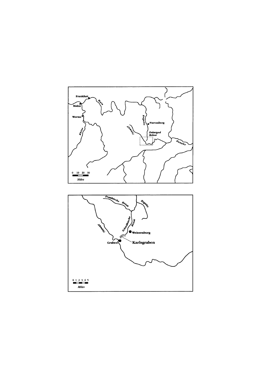
MAP 1
THE ‘CONTINENTAL DIVIDE’ AND GERMANY

14
PAST AND PRESENT
NUMBER
176
operation. Some have imagined that increasing commercial con-
tacts with central Europe was Charlemagne’s goal, though there
is scanty evidence for this supposition.
4 Charlemagne did legislate
about trade with the Slavs who lived east of his realm, but he
never took a very active interest in building commercial infra-
structures, even in the most commercially vigorous areas he ruled.
It is difficult to envisage Charles undertaking a task of the size
of the Rezat–Altmu¨hl connector in order to ease the movements
of a few merchants (and smugglers) in a peripheral region far
from Francia.
5 Most scholars have therefore accepted the associ-
ation between the canal and the Frankish campaign against the
Avars, central European neighbours of the Carolingians whom
Charles might reach more handily (
percommode) by means of a
navigable route between Francia and the Danube basin. The
revised
Royal Frankish Annals themselves make this association.
6
Yet such amphibious operations were not familiar to the Frankish
army, and, since the Franks were perfectly capable of first over-
whelming and then annihilating the Avar confederation without
any canals, as was proved in 791 and 796, we should wonder
whether Avar wars really motivated Charles’s moment of enthusi-
asm for a monumental trench. The Carolingian writers implied
that this ill-fated project
distracted the king from the business of
ruling, and therefore of waging war, and his presence at the work
site, with his entire entourage, was indeed unheard of for a king
of his line. The digging also diverted military manpower, which
may be what really disturbed those chroniclers who implied causal
ties between foreign attacks on the realm and the canal-building
4 Karl Theodor von Imana-Sternegg, Deutsche Wirtschaftsgeschichte (Leipzig, 1909),
594; Detlev Ellmers,
Fru¨hmittelalterliche Handelsschiffahrt in Mittel- und Nordeuropa
(Neumu¨nster, 1972), 232–3.
5 Matthias Hardt, ‘Hesse, Elbe, Saale and the Frontiers of the Carolingian Empire’,
in Walter Pohl, Ian Wood and Helmut Reimitz (eds.),
The Transformation of Frontiers
from Late Antiquity to the Carolingians (Leiden, 2001), 229; Michael Schmauder,
‘U
¨ berlegungen zur o¨stlichen Grenze des karolingischen Reiches unter Karl dem
Grossen’, in Walter Pohl and Helmut Reimitz (eds.),
Grenze und Differenz im fru¨hen
Mittelalter (Vienna, 2000), 58.
6 Pierre Riche´, Les Carolingiens (Paris, 1983), 99–100 and Hanns Hubert Hofmann,
‘Fossa Carolina: Versuch einer Zusammenschau’, in H. Beumann (ed.),
Karl der
Grosse: Lebenswerk und Nachleben, 5 vols. (Dusseldorf, 1965–8), i, 439–40, epitomize
this scholarship. Adrian E. Verhulst, ‘Karolingische Agrarpolitik’,
Zeitschrift fu¨r
Agrargeschichte und Agrarsoziologie, xiii (1965), 179–80, describes the military con-
sequences of the 793 shortages, with the canal as a way around expensive animal
hauling (Braudel’s ‘no oats, no war’ axiom). But such structural change was dispropor-
tionate to an episode of famine.

15
DIGGING DITCHES IN EARLY MEDIEVAL EUROPE
venture.
7 Although joining the Rhine and Danube is an idea that
has occupied several governments in modern Germany, in the
early Middle Ages the locks which were an essential component
of the engineering for such a canal were unknown, and so the
Carolingian effort between Rezat and Altmu¨hl was unlikely to
amount to much even if the weather, the Saxons, and the Saracens
had been more clement.
8 In other words the movement of almost
one million cubic metres of earth was not necessarily the sanest
strategy to adopt in that particular corner of Bavaria in the midst
of a volatile military situation.
9
For a full understanding of Charlemagne’s activities in those
late months of 793 the immediate background of wars and tactics
appears insufficient. Placing this episode in a wider context is
more fruitful, a context in which other contemporary examples
of rulers engaged in gigantic earth-moving schemes receive due
consideration. For however exceptional the events of autumn 793
were in Charlemagne’s career, he was not the only early medieval
potentate to try his hand at ditch-digging. In fact the eighth and
ninth centuries were a time of vigorous activity in this special
field of endeavour. Between the early 700s, which saw the con-
struction of a set of Danish earthworks, and the early 800s, when
a dyke stretching for some 140 kilometres was built in Thrace,
several rulers and thousands of excavators, not to mention the
logistical workers and the animals and tools they used, created a
7 This is evident in the accounts of Poeta Saxo, Annales Regni Francorum, and
Annales Laureshamenses.
8 The ‘Karlsgraben’ obtained new notoriety in the late 1900s because it seemed to
prefigure the modern Rhine–Danube canal which preoccupied German politicians and
environmentalists. See Bill Bryson, ‘Main–Danube Canal Links Europe’s Waterways’,
National Geographic Mag., clxxxii, no. 2 (Sept. 1992), for an example of this juxtaposi-
tion; see also Klaus Goldmann, ‘Das Altmu¨hl Damm-Projekt: Die Fossa Carolina’,
Acta Praehistorica et Archaeologica, xvi–xvii (1984–5), 215; Konrad Elmsha¨user,
‘Kanalbau und technische Wasserfu¨hrung im fru¨hen Mittelalter’,
Technikgeschichte,
lix (1992), 15. To justify this apparently doomed attempt to build an uphill canal,
the simultaneous construction of retaining dams designed to bring the waters of the
Rezat up to the level of those of the Altmu¨hl (17 metres difference) have been
postulated (Goldmann, ‘Das Altmu¨hl Damm-Projekt’), as has a ‘stepped’ series of
long ponds: see R. Koch and G. Leininger, ‘Der Karlsgraben-Ergebnisse neuer
Erkundigungen’,
Bau Intern (1993), 14–15; Klaus Grewe, ‘Der Karlsgraben bei
Weissenburg’,
Europa¨ische Technik im Mittelalter, 800 bis 1200 (Berlin, 1996), 111–15.
9 Calculations of scale and volume are made by Hofmann, ‘Fossa Carolina’, 446–51.
In 793 Charles was recovering from his son’s rebellion, so displays of power will have
been most useful. Buc’s observation that Carolingian magnates formed an audience
prone to creative interpretation of royal ‘rituals’ is pertinent to the textual tradition
about the digging: Philippe Buc,
The Dangers of Ritual (Princeton, 2001), 249–50, 260.

16
PAST AND PRESENT
NUMBER
176
series of spectacular furrows that, for a time, both changed the
landscapes they traversed and reordered local social relations.
These diggings merit serious investigation. Their individual
study, while invaluable for the knowledge of each structure
it produces, obscures the similarities among structures like
Charlemagne’s canal (or the Karlsgraben), Offa’s Dyke, the Great
Fence of Thrace (or the Erkesia) and the Danevirke, to name
only the most prominent examples.
10 Examined together, the
massive trenches created by early medieval rulers, while canaliz-
ing waters or securing the realm, permit a glimpse into the
mechanics of royal power. They show how the powerful in early
medieval Europe mobilized human resources to modify the nat-
ural environment. As the
Royal Frankish Annals and other
Carolingian accounts of Charles’s failed ditch reveal, during the
early Middle Ages environmental modification on this large scale
was no neutral act, but was intimately bound up with the exercise
of power and its justification.
11
This essay proposes a more culturally inflected understanding
of the great early medieval efforts in excavation than has hitherto
held sway. It suggests that the extensive ditches which appeared
in diverse parts of Europe during the ‘long’ eighth century were
one of the true marks of authority at that time, and should be
investigated as such.
12 Their construction was a visible achieve-
10 These are the more celebrated and better documented examples, but similar
structures existed in Ukraine: Simon Franklin and Jonathan Shepard,
The Emergence
of Rus, 750–1200 (London, 1996), 172–3, 208; in Bessarabia and the Dobrudja: Ioana
Bogdan Cataniciu, ‘I valli di Traiano’, in Marius Porumb (ed.),
Omaggio a Dinu
Adamasteanu (Cluj, 1996); in Hungary: Sa´ndor Soproni, Die spa¨tro¨mische Limes
zwischen Esztergom und Szentendre (Budapest, 1978), 113–37; and, though there was
some stone wall, in Apulia: Jean-Marie Martin, ‘Les Proble`mes de la frontie`re en
Italie me´ridionale (VI
e–XIIe sie`cles)’, Castrum, iv (Rome and Madrid, 1992), 265–7.
Stranieri thinks it is a high medieval boundary: Giovanni Stranieri, ‘Un limes bizantino
nel Salento?’,
Archeologia medievale, xxvii (2000), 334–43.
11 The classic on how hegemony becomes inscribed on landscapes is Henri Lefebvre,
The Production of Space (Oxford, 1991). See also Edward W. Soja, Postmodern
Geographies: The Reassertion of Space in Critical Social Theory (London, 1989), 6–7,
and, for a less optimistic view, Ge´rard Chouquer, ‘La Place de l’analyse des syste`mes
spatiaux dans l’e´tude des paysages du passe´’, in Ge´rard Chouquer (ed.),
Les Formes
du paysage, 2 vols. (Paris, 1996), ii, 14–19. On early medieval rulers’ self-
representation through building, see Bettina Pferschy, ‘Bauten und Baupolitik
fru¨hmittelalterlicher Ko¨nige’,
Mitteilungen des Instituts fu¨r O
¨ sterreichische Geschichts-
forschung, xcvii (1989).
12 Ditches are not among the canonical ‘Herrschaftszeichen’, which instead include
diadems, sceptres, orbs, and the like: Percy Ernst Schramm,
Herrschaftszeichen und
Staatsymbolik: Beitrage zu ihrer Geschichte von dritten bis zum sechszehnten Jahrhundert,
3 vols. (Stuttgart, 1954–6).

17
DIGGING DITCHES IN EARLY MEDIEVAL EUROPE
ment that manifested the capacities and fitness to rule of the
mighty men who associated themselves with the projects.
Whether for canals or dykes, digging ditches was a demonstrative
act, part of the communication through deeds which, recent
researches have shown, characterized early medieval political
communities.
13 The audiences for whom early medieval rulers
staged the demonstration were various, as we shall see, and
included both the powerless and the potent. Interestingly, the
ditch-digging logic of post-classical European rulers might have
been understood far away from early medieval Europe, too.
Although the goals towards which the Negara rulers of pre-
colonial Indonesia directed labour, wealth, and expertise were
lavish ceremonies, not excavations, these potentates likewise
sought activities whereby the princely qualities of the ruler
became manifest.
14 As in early medieval Europe, so in early
modern Indonesia the representation of reality, albeit brief and
fleeting, shaped and nurtured that reality, and hence was politic-
ally useful. Early medieval khans and kings did not, perhaps, live
in ‘theatre states’, but the almost ritual digging of ditches with,
as we shall see, little practical application, was a theatrical act.
Like Negara ceremonies, ditches made obvious their organizers’
ability to wield power, to obtain compliance from all participants,
from the surveyors to the diggers to the guards. The diggers’
compliance need not imply belief in the need for, or efficacy of,
the ditches, but was, rather, a ‘public display of complicity in
the fictions of the state’,
15 in particular of the king or khan who
inspired the particular digging exercise over which the diggers
laboured. Early medieval ditch-digging, it will be argued, symbol-
ized leaders’ authority and its acceptance by both the powerful
and the wielders of the spades. The ditches were thus an ‘effective
fiction’ around which consensus could coalesce.
13 Gerd Althoff, Spielregeln der Politik im Mittelalter: Kommunikation in Friede und
Fehde (Darmstadt, 1997), 1–13, 229–57 (his famous 1993 article on ‘Demonstration
und Inszenierung’).
14 Clifford Geertz, Negara: The Theatre State in Nineteenth-Century Bali (Princeton,
1980), esp. 120–3. For Buc,
Dangers of Ritual, 227–37, Geertzian ideas on power
representation are inapplicable to early medieval Europe, whence no rituals (only
texts about them) have survived; but some rituals leave archaeological, as well as
textual, traces.
15 In the words of Raymond Grew, ‘Editorial Foreword’, Comparative Studies in
Society and Hist., xl (1998), 414. See also Stephen Jay Greenblatt, Renaissance Self-
Fashioning (Chicago, 1980), 13, for whom ‘power manifests itself in the ability to
impose one’s fictions upon the world’.

18
PAST AND PRESENT
NUMBER
176
The effect of the fiction depended to a large extent on the kind
of place where that fiction was enacted. Each of the great post-
classical ditches traversed a distinctive locality, or set of localities.
Although the Karlsgraben’s situation was different from those of
the Erkesia, the Danevirke, and Offa’s Dyke, each of the digging
exercises occurred in a place where the authority of the rulers
was recent, contested, and difficult. Whether in northern Bavaria,
in the foothills of the Cambrian or Balkan mountains, or in
southern Scandinavia, each digging took place in a borderland,
on the edge of the territories whence the kings drew their power
and where royal desires did not always prevail. Such borderlands
are often places of state ‘superinvestment’.
16 Using a paradigm
developed by James Scott to understand the sometimes inscrutable
activities of twentieth-century states, we might say that it is in
their borderlands that such states pursue cosmetic ‘miniaturiza-
tion’ with greatest zeal.
17 For Scott, the imperative to create ‘state
spaces’, in which control of resources is easiest for governors, is
a typical characteristic of ‘high modernist’, or twentieth-century,
states. In areas where states cannot establish the geometries and
rationalities for which they have a predilection and need, states
resort to forming ‘a fac¸ade or small, easily managed zone of
order’, a miniature version of the ideal generalized order which
remains unattainable. Borderlands are precisely the kinds of
places where ‘miniaturization’ has the most resonance and poten-
tial, and in their ditch-digging, I will argue, early medieval states
pursued a form of ‘miniaturization’ there. Although early medi-
eval rulers did not aspire to the level of social control and discip-
line which the narrowed focus of ‘miniaturization’ has afforded
to recent governments, their monumental constructions in sensit-
ive, vulnerable areas did increase their presence and power.
18
16 See Pierre Toubert, ‘Frontie`re et frontie`res’, Castrum, iv (Rome and Madrid,
1992), 15, on ‘surinvestissement de pouvoir publique’ in borderlands. Ulf Na¨sman,
‘Exchange and Politics: The Eighth Century in Denmark’, in Inge Lyse Hansen and
Chris Wickham (eds.),
The Long Eighth Century (Leiden, 2000), 64–7, stresses the
centrality of south Jutland to Danish kings.
17 James C. Scott, Seeing Like a State: How Certain Schemes to Improve the Human
Condition Have Failed (New Haven, 1998), 196, 257–8. More than palaces, royal and
papal farms are places where early medieval ‘miniaturization’ might be divined.
18 They were not alone, among pre-modern rulers, in using simple building projects
of questionable practical utility in this way. The fabled ‘Great Wall of China’, about
which astonishing myths have circulated well into the ‘information age’, is another
example of a borderland investment without the military usefulness it is imagined to
have had. The ‘Great Wall’ too is a ‘miniaturization’, an effort by Ming dynasts to
send messages, especially to their subjects, by means of mastodontic monuments:
(cont. on p. 19)

19
DIGGING DITCHES IN EARLY MEDIEVAL EUROPE
II
Discussion and analysis of the great diggings from the early
Middle Ages has been restricted to single monuments and has
proceeded within the national historiographies of the modern
countries where the trenches happen to lie;
19 nevertheless, conclu-
sions about them have been consistent. Two main interpretations
have been advanced for the lengthy linear earthworks like the
Danevirke, Offa’s Dyke, and the Great Fence of Thrace. The
ditch-and-bank structures are seen either as military emplace-
ments relevant to the defence of territory, or they are imagined
to have been boundary markers signalling the limits of a particular
authority, or a combination of both.
20 What these interpretations
share with the predominant understanding of the canal that
Charles built is that they are straightforwardly functional. The
efforts and investments these excavation projects represent thus
emerge as logical responses to the pragmatic needs of early medi-
eval rulers and societies. Despite this surprising harmony of
(n. 18 cont.)
Arthur Waldron,
The Great Wall of China: From History to Myth (Cambridge, 1990),
3–9, 16–21, 108–15, 189–91. Peter Heather, ‘The Late Roman Art of Client
Management: Imperial Defence in the Fourth-Century West’, in Pohl, Wood and
Reimitz (eds.),
Transformation of Frontiers, 38–9, 46–58, makes similar points about
the Danubian
limes.
19 Honourable exceptions are: Uwe Fiedler, ‘Zur Datierung der Langwalle an der
mittleren und unteren Donau’,
Archa¨ologisches Korrespondenzblatt, xvi (1986), who
tries to understand all Balkan dykes together; Joe¨lle Napoli,
Recherches sur les fortifica-
tions line´aires romaines (Rome, 1997), which never ventures beyond Late Antiquity,
but is ecumenical; Bernard S. Bachrach, ‘On Roman Ramparts’, in Geoffrey Parker
(ed.),
The Cambridge Illustrated History of Warfare (Cambridge, 1995), on tactical
affinities between Roman ramparts and post-classical earthworks; Bernard S.
Bachrach, ‘Logistics in Pre-Crusade Europe’, in John A. Lynn (ed.),
Feeding Mars:
Logistics in Western Warfare from the Middle Ages to the Present (Boulder, 1993), 57,
treats both dykes and Charles’s canal as proof of excellent early medieval logistics.
20 A few examples of military ‘readings’: Veselin Besˇevliev, Die protobulgarische
Periode der bulgarischen Geschichte (Amsterdam, 1981), 477; N. J. Higham, An English
Empire (Manchester, 1995), 140; P. Eveson, ‘Offa’s Dyke at Dudston in Chirbury,
Shropshire’,
Landscape Hist., xiii (1991), 61; H. H. Andersen, ‘Das Danewerk als
Ausdruck mittelalterlicher Befestigungeskunst’,
Chateau Gaillard, xi (1983), 9–10.
Examples of border-marking interpretations: Peter Soustal, ‘Bemerkungen zur byzan-
tinisch-bulgarischen Grenze im 9. Jahrhundert’,
Mitteilungen des bulgarischen
Forschungsinstitutes in O
¨ sterreich, viii (1986), 151; Karel Sˇkorpil, ‘Constructions milit-
aires strate´giques dans la re´gion de la mer Noire’,
Byzantinoslavica, iii (1931), 29; Sir
Cyril Fox,
Offa’s Dyke (London, 1955), 28, 44, 218, presented the dyke as ‘strategic’
but not always defensible; Cyril Hart, ‘The Kingdom of Mercia’, in Ann Dornier
(ed.),
Mercian Studies (Leicester, 1977), 53; Henning Unverhau, Untersuchungen zur
historischen Entwicklung des Landes zwischen Schlei und Eider im Mittelalter
(Neumu¨nster, 1990), 11, 16–17. Collins,
Charlemagne, 168, combines defence, xeno-
phobia, and control of commerce in the most original interpretation of the Danevirke.

20
PAST AND PRESENT
NUMBER
176
interpretation, there are considerable limitations to these func-
tionalist readings of Europe’s post-classical trenches. Indeed,
there are enough flaws in the functional explanations to justify
seeking ulterior ones, like those suggested in this essay. Certainly
the diggers may also have sought to denote a boundary or prepare
for an invasion, but at the time of construction other reasons for
digging ditches outweighed and overrode border-marking and
fortification.
The notion that the great excavation projects derived from a
desire to create military preparedness or defensibility has several
weaknesses. To begin with, the scale of the earth-moving endeav-
ours in Schleswig-Holstein, Thrace, and the borders of Wales
was enormous. The Danevirke is actually a succession of distinct
ditch-and-bank structures, at least three of which date to the
early Middle Ages. The first Danevirke, dendrochronologically
dated to around 737, but preceded by some excavations a genera-
tion or so earlier, is some seven kilometres long, with a U-shaped
ditch one and a half metres deep and five metres wide, with
a two-metre-high bank. The entire dyke, including the berm,
stretches across some twenty metres. In the second major con-
struction phase, associated with the Kovirke’s seven kilometres
of V-shaped, three-metre-deep and four-metre-wide ditch, plus
a bank about two metres high, scholars have seen the hand of
King Godfrid (
c.800–10), for the Carbon-14 date is eighth–ninth
century. Finally, in about 968, some twenty kilometres of the
third Danevirke were built, much of it an accretion on top of
the earliest earthwork. Its bank reached three metres in height
and thirteen metres in breadth.
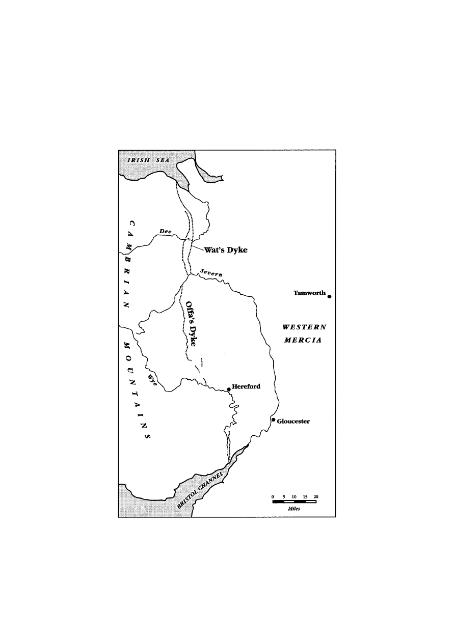
21 Offa’s Dyke is much longer and
grander, and although, after Sir Cyril Fox’s pioneering publica-
tions culminating in his
Offa’s Dyke of 1955, archaeologists have
21 Following excavations in the early 1980s — Willi Kramer, ‘Die Datierung der
Feldsteinmauer des Danewerks: Vorbericht einer neuen Ausgrabung am Hauptwall’,
Archa¨ologisches Korrespondenzblatt, xiv (1984) — H. Hellmuth Andersen revised his
chronology somewhat (see his
Danevirke og Kovirke: Archaeologiske Undersogelser,
1861–1993, Aarhus, 1998, for the ‘definitive’ version), allowing that some late seventh-
or early eighth-century structures underlay the ‘first’ Danevirke as outlined in
H. Hellmuth Andersen, H. J. Madsen and Olfert Voss,
Danevirke, 2 vols.
(Copenhagen, 1976), ii, 93–4, and Henning Hellmuth Andersen, ‘Das Danewerk als
Ausdruck’, in Herbert Jankuhn, Kurt Schietzel and Hans Reichstein (eds.),
Archa¨ologische und naturwissenschaftliche Untersuchungen an la¨ndlichen und fru¨hsta¨dt-
lichen Siedlungen im deutschen Kustgebiet vom 5. Jahrhundert vor Chr. bis zum 11.
Jahrhundert nach Chr., ii (Weinheim, 1984), 191–5. For a good summary, see Joachim
Stark,
Haithabu–Schleswig–Danewerk (Oxford, 1988), 108–28.

21
DIGGING DITCHES IN EARLY MEDIEVAL EUROPE
reduced its length, it is still regarded as involving more than a
hundred kilometres of ditches and banks (see Map 2). The
Mercian ditch varies from one to four metres in depth, and its
embankment in some places is almost six metres high, though
mostly it is much smaller. On average this dyke’s width is twenty
metres.
22 Similar proportions characterize the Great Fence of
Thrace, which the Ottoman empire knew as the Erkesia, or ‘the
place that is cut’. It is almost 140 kilometres long: the ditch was
about a metre deep, the bank, made of the fill from the ditch,
was a metre high, and the whole structure extended across some
eighteen metres.
23 All the dykes were very substantial construc-
tions when they were made, far more so than they are today.
Such a grand scale poses difficulties for comprehending the
military use of the dykes. In the light of the modest size of early
medieval armies, the length of these barriers is puzzling. Early
medieval strategists imagined that it took one soldier to defend
every 1.3 metres of fortifications, so the very long dykes would
demand very large concentrations of troops. Since the linear
disposition of the dykes meant redeployment of troops could not
benefit from the shorter, diametrical, distances that perimetral
fortifications permitted, the hypothetical defenders of the dykes
would have required still larger armies.
24 The defence of the
realm, at least in Mercia and Francia, in theory might involve
most able-bodied male subjects — a sort of early medieval
leve´e
en masse.
25 But in practice such generalized levies were unknown
and never attempted, and even in the ninth century, when locals
might mobilize for defence, they were defending small centres.
Thus, the linear fosses in Jutland, Mercia, and Thrace were hard
to patrol effectively and impossible to defend or garrison when
22 David H. Hill, ‘The Construction of Offa’s Dyke’, Antiquaries Jl, lxv (1985),
141; Fox,
Offa’s Dyke, 44, 78, 277; Patrick Wormald, ‘The Age of Offa and Alcuin’,
in James Campbell (ed.),
The Anglo-Saxons (Oxford, 1982), 119–21; for a brief
overview of
reconsiderations since
Fox’s magisterial
survey, see
Margaret
Worthington, ‘Offa’s Dyke’, in Michael Lapidge (ed.),
The Blackwell Encyclopaedia
of Anglo-Saxon England (Oxford, 1999). David Hill, ‘Offa’s Dyke: Pattern and
Purpose’,
Antiquaries Jl, lxxx (2000), prunes the dyke to a mere 103 kilometres.
23 J. B. Bury, ‘The Bulgarian Treaty of 814 and the Great Fence of Thrace’, Eng.
Hist. Rev., xxv (1910), 282–3, which rebaptized the Erkesia in English; R. Rasˇev,
Starobalgarski Ukreplenija na Dolnija Dunav (Varna, 1982), 62–4; Peter Soustal,
Thrakien: Thrake, Rodope, Haimimontos (Vienna, 1991), 261–2; Soustal, ‘Bemerk-
ungen zur byzantinisch-bulgarischen Grenze’, 150–2.
24 Bernard S. Bachrach, Early Carolingian Warfare: Prelude to Empire (Philadelphia,
2001), 235, 239, on military aspects of perimetral defences.
25 Ibid., 52–4.

22
PAST AND PRESENT
NUMBER
176
they were made, before artillery and conscription. Although the
Bulgar khans may have had access to somewhat greater military
resources than Anglo-Saxon kings and Danish rulers, like other
post-classical rulers they relied on small contingents of aristocratic
retainers and loyal dependants for real fighting.
26 This meant that
to field more than a few thousand (five thousand is the canonical
number for Charlemagne’s host) fighting men was a feat. Keeping
them in the field for more than a few weeks without access to
looting, that is, in exactly the sort of defensive war the dykes are
postulated to have served, was usually beyond the capabilities of
early medieval rulers.
27 The logistical arrangements of the most
effective fighting force known in the early Middle Ages, the
Carolingian army, as outlined in Carolingian edicts, do not appear
equal to the strain of supporting several thousand soldiers along
a structure like Offa’s Dyke for significant periods of time.
28
Considerations of this sort call into question whether these same
early medieval rulers would have gone to the trouble of building
such vast earthworks if defensive warfare was their primary
preoccupation (which in Mercia’s, Bulgaria’s, and Denmark’s
expansive, aggressive ‘long’ eighth century, it was not).
In addition, the siting of the ramparts was militarily awkward,
sometimes incomprehensible. In places the dykes are exposed
to commanding positions across the ditch, while in others
they offered no retreat save into bogs.
29 All had numerous and
26 Robert Browning, Byzantium and Bulgaria (London, 1975), 114, accepted over-
awed Byzantine estimates of thirty thousand in one Bulgar army. John Haldon,
Warfare, State and Society in the Byzantine World, 565–1204 (London, 1999), 99–106,
gives reasons for thinking Balkan armies were small.
27 Laudable efforts to revise early medieval army sizes upwards do not alter the
picture for the practicality of earthworks: Bernard S. Bachrach, ‘Early Medieval
Military Demography: Some Observations on the Methods of Hans Delbru¨ck’, in
Donald J. Kagay and L. J. Andrew Villelon (eds.),
The Circle of War in the Middle
Ages (Woodbridge, 1999); Karl Ferdinand Werner, ‘Heeresorganisation und
Kriegsfu¨hrung im deutschen Ko¨nigsreich des 10. und 11. Jahrhundert’,
Settimane di
studio del CISAM, xv (1968), 813–22. For the traditional view, see Franc¸ois L.
Ganshof, ‘L’Arme´e sous les Carolingiens’,
Settimane di studio del CISAM, xv (1968);
Richard P. Abels,
Lordship and Military Obligation in Anglo-Saxon England (Berkeley,
1988), 34–6; Lotte Hedeager, ‘Kingdoms, Ethnicity and Material Culture’, in M. O. H.
Carver (ed.),
The Age of Sutton Hoo (Woodbridge, 1992), 287, 298.
28 Bachrach, ‘Logistics in Pre-Crusade Europe’, 69; Bachrach, Early Carolingian
Warfare, 136–7, 239. He is optimistic about Carolingian capabilities.
29 As noted by Fox, Offa’s Dyke, 279–81; N. J. Higham, The Origins of Cheshire
(Manchester, 1993), 99; Frank Noble,
Offa’s Dyke Reviewed (Oxford, 1983),
66; Andersen, ‘Das Danewerk als Ausdruck’, 11; Herbert Jankuhn,
Haithabu:
Ein Handelsplatz der Wikingerzeit (Neumu¨nster, 1972), 66–8; Herbert Jankuhn,
‘Die Befestigungen um Haithabu’, in Jankuhn, Schietzel and Reichstein (eds.),
(cont. on p. 24)
MAP 2
WALES AND WESTERN MERCIA

24
PAST AND PRESENT
NUMBER
176
potentially dangerous gaps in their courses, through which enemies
could easily slip to outflank any hapless defenders, and until the
mid-900s, when the so-called ‘Verbindungswall’ closed the north-
east passage into Jutland at Hedeby, a major Achilles heel was open
to assailants of the Danevirke (see Map 3). The grander segments
of Offa’s Dyke, where impediments to crossing were greatest, do
not correspond to any known Mercian strategic interests, and actu-
ally some of the weakest, shallowest parts of the dyke, and some of
the longest gaps in it, lay across the most obvious routes for any
Welsh attack on the Mercian heartlands around Tamworth.
Although later twentieth-century investigations have filled in many
of the gaps perceived by Fox, the notion that the river Wye was a
barrier equivalent to the dyke along the forty kilometres where no
dyke existed is problematic: rivers in the early Middle Ages were a
means of communication and union, not of division, and the Wye
is easily fordable at several points. In the case both of the Great
Fence and of the Danevirke, roads pierced the trenches without
any significant reinforcement of the vital intersection between road
and fosse. Both in Thrace and in Denmark defenders were also
liable to outflanking by seaborne enemies, of whom there were
considerable numbers in the Baltic and the Black Sea regions. In
fact, the Byzantines, against whom the Erkesia was presumably
directed, enjoyed a Black Sea thalassocracy, while the seventh cen-
tury witnessed the development of new versatile, fast ships among
the Scandinavians and Slavs, thus making naval attacks much
easier.
30 Moreover, only the Danevirke, in all three of its early
(n. 29 cont.)
Archa¨ologische und naturwissenschaftliche Untersuchungen; G. Haseloff, ‘Die Aus-
grabungen am Danewerk und Ihre Ergebnisse’, in
Offa, ii (1937), 117.
30 On Offa’s neglect of ‘defences’ for vital portions of Mercia, and the odd elabora-
tion of the dyke at Clun Forest, see Fox,
Offa’s Dyke, 160, 171, 207–11, 218; Sir
Cyril Fox, ‘The Boundary Line of Cymru’,
Proc. Brit. Acad., xxvi (1940), 279, 290,
295; Noble,
Offa’s Dyke Reviewed, 6, 9, 42, 60–2, 66, 80; John Davies, A History of
Wales (London, 1990), 65–6; Margaret Gelling, The West Midlands in the Early Middle
Ages (Leicester, 1992), 106. On sea routes in the western Black Sea, see D. Obolensky,
‘Byzantium and its Northern Neighbours, 565–1018’, in J. M. Hussey (ed.),
Cambridge
Medieval History, iv, pt 1 (Cambridge, 1966), 490; Georgije Ostrogorski, History of
the Byzantine State (Oxford, 1968), 168–9; Veselin Besˇevliev, ‘Die Feldzu¨ge des
Kaisers Konstantin V. gegen die Bulgaren’,
E
´ tudes balcaniques, vii (1971), 13–16;
Vasil Gjuzelev, ‘Il mar nero ed il suo litorale nella storia del medioevo bulgaro’,
Byzantino-bulgarica, vii (1981), 15–17. The Fence petered out at Makrolivada, where
the commodious Adrianople–Serdica highway passed (Bury, ‘Bulgarian Treaty of
814’, 283), and was unreinforced on its eastern end, where two north–south roads
from Constantinople to the Danube passed: D. Obolensky, ‘Byzantine Frontier Zones
and Cultural Exchanges’,
Actes du XIV
e congre`s internationale d’e´tudes byzantines, 2
vols. (Bucharest, 1974–5), i, 304. On the ‘Heerweg’, the great north–south road
(cont. on p. 26)
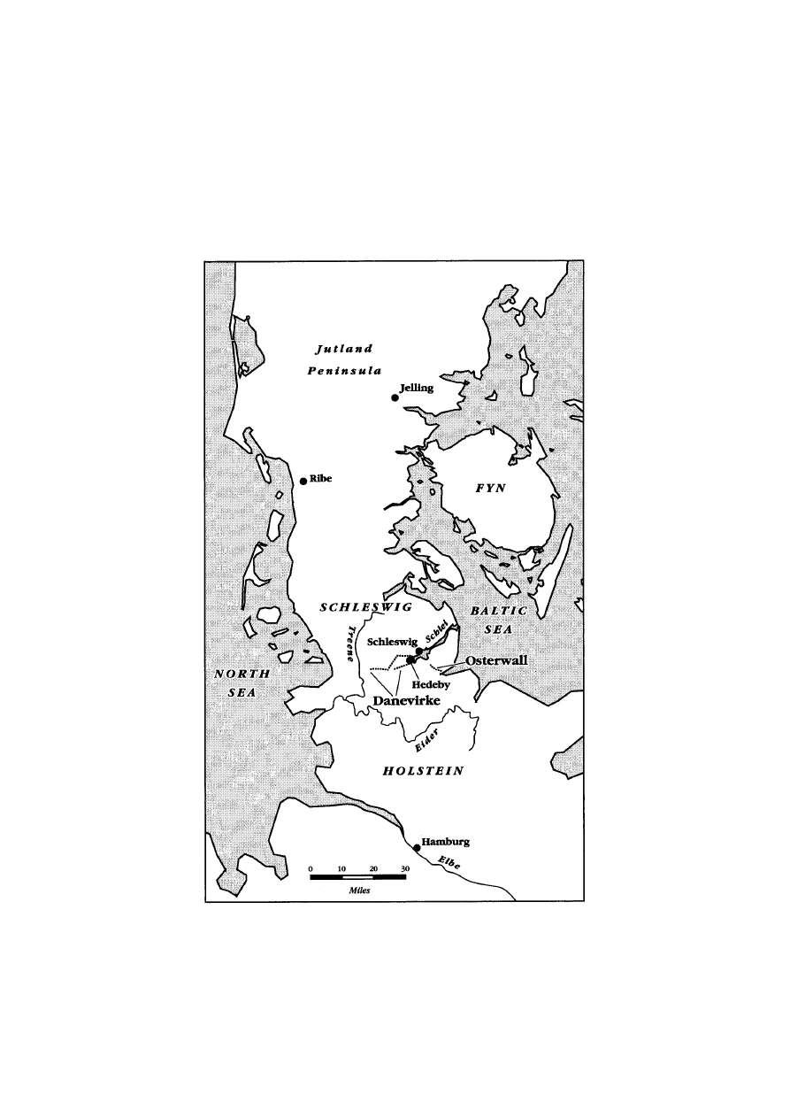
MAP 3
EARLY MEDIEVAL DENMARK

26
PAST AND PRESENT
NUMBER
176
medieval incarnations, had a wooden palisade on top of its bank
and seems related to a nearby stronghold (Hedeby was fortified
in the 800s), but because of its ample berm, assailants who got
across the ditch were beyond the line of fire of whoever manned
the palisade. In sum, the dykes had weak or no additional forti-
fications, and no forts, redoubts or garrison-housing along their
course.
31 Since the ditches sloped gently, had comfortable berms,
and the banks also had soft contours, the dykes offered little to
slow horse- or foot-borne traffic in the event of a frontal attack.
Thus they were not good ‘Anna¨herungshindernisse’ either.
32
Burdened with so many tactical disadvantages, we would expect
earthworks to suffer a bad reputation among early medieval
writers on military affairs — and, indeed, those who wrote about
them took a dim view of the dykes’ military efficacy. Their
principal weakness had been singled out in the sixth century by
the Byzantine author and connoisseur of fortifications, Procopius
of Caesarea. His catalogue of the emperor Justinian’s building
projects, famous for its account of the construction of Haghia
Sophia, enumerates scores of outposts, city walls, and forts built
as part of a scheme to secure the Roman Empire from barbarian
challenges. Procopius’ work was a panegyric, designed to contrast
the idle efforts of Justinian’s predecessors with the glorious,
invincible structures of Justinian. But his acid evaluations of the
Long Wall erected by the emperor Anastasius in southern Thrace
was based on observed facts. The Long Wall, cutting Thrace
from Constantinople’s hinterland, was forty-five kilometres long
and the empire did not have enough soldiers to man it effectively.
(n. 30 cont.)
through Denmark, see E. Ehrhardt, ‘Heerweg’,
Lexikon des Mittelalters, iv (Munich,
1989), cols. 2008–9. The Kograben had a gateway where the Heerweg pierced it:
Stark,
Haithabu–Schleswig–Danewerk, 114–15. On Mercian roads, see Fox, Offa’s
Dyke, 221. On the purpose of the Verbindungswall, see Andersen, ‘Das Danewerk
als Ausdruck’, 195. On shipping technology in relation to fortification, see O. Olsen,
‘Royal Power in Viking-Age Denmark’, in H. Galinie´ (ed.),
Les Mondes normands
(VIII–XII s.) (Caen, 1989), 31–2.
31 Haseloff, ‘Die Ausgrabungen am Danewerk’, 118; David Hill, ‘Offa’s and Wat’s
Dykes: Some Aspects of Recent Work’,
Trans. Lancs. and Cheshire Antiq. Soc., lxxix
(1977), 33; Worthington, ‘Offa’s Dyke’, 344; K. R. Dark,
From Civitas to Kingdom:
British Political Continuity, 300–800 (Leicester, 1994), 117. Long-term garrisoning
was in any case rare in post-classical times.
32 Harald von Petrikovits, ‘U¨ber die Herkunft der Anna¨herungshindernisse an den
ro¨mischen Milita¨rgrenzen’,
Studien zu den Milita¨rgrenzen Roms: Vortra¨ge des 6.
Internationalen Limeskongresses in Su¨ddeutschland (Cologne, 1967).

27
DIGGING DITCHES IN EARLY MEDIEVAL EUROPE
Inevitably, it failed to halt incursions against the capital: three
times in Procopius’ lifetime, scores of times thereafter.
33 For
Procopius massive linear defences were flawed by their sheer size
and were thus tactically worthless.
Similar views were held far from the Mediterranean, in places
with a fraction of the military resources available to the sixth-
century Byzantine empire. The Venerable Bede, who lived close
to one of the most famous and best-researched linear defences in
Europe (Hadrian’s Wall, between Tyne and Solway) was curious
about dykes and their construction. His description of these bar-
riers drew on several late antique texts, including those of
Orosius, Vegetius, and Gildas. For Bede earthworks were a bar-
barous substitute for proper fortifications and were good for
nothing (
ad nihil utilem). He argued that the Romans had known
how to build useful blockages capable of keeping intruders out,
but they had used masonry; when their leadership failed and the
British population attempted to erect ersatz barriers from turf,
the result was unable to withstand attacks. Although Bede gave
the Britons an alibi by suggesting that the absence of craftspeople
had played a role in the failure to erect a Roman-style wall, he
also suggested that earth ramparts had tactical limitations and
were an inferior artefact that no competent defender would build.
On this he followed Gildas, who knew what he was talking about
as he seems to have lived in a time of considerable dyke-building
activity, but who did not consider long earthworks militarily
viable.
34
33 Procopius, On Buildings,
IV
. 9. 6–8. On Procopius’ authorial intentions, see Averil
Cameron,
Procopius and the Sixth Century (London, 1985), 84–9, 110. For a list of
incursions across the walls, see Feridun Dirimtekin, ‘Le mura di Anastasio I’,
Palladio,
v (1955), 87. See also Michael Whitby, ‘The Long Walls of Constantinople’,
Byzantion,
xl (1985), 560–76. On Justinian’s other lengthy fortifications, see Robert L.
Hohlfelder, ‘Trans-Isthmian Walls in the Age of Justinian’,
Greek, Roman, and
Byzantine Studies, xviii (1977). The Wall became the Ottoman Chatalya line when
gunpowder warfare prevailed, and remains a military zone.
34 Bede, Historia Ecclesiastica,
I
. 5, 12 (ed. Charles Plummer, Oxford, 1896), which
he reiterated in his
Chronica Maiora,
AM
4163, 4377 (ed. Ch. W. Jones, Corpus
Christianorum, Series Latina, Turnhout, 1977, 502, 515–16). For a commentary, see
Walter Goffart,
The Narrators of Barbarian History (Princeton, 1988), 300–2; J. M.
Wallace-Hadrill,
Bede’s ‘Ecclesastical History of the English People’: A Historical
Commentary (Oxford, 1988), 11–12, 17–18. See Orosius, Historiarum Libri VII,
XVII
.
7 (ed. Marie-Pierre Arnaud-Lindet, Paris, 1991, iii, 52); Vegetius,
Epitome Rei
Militaris,
I
. 24 (ed. Karl Lang, Leipzig, 1885, 26). Passages in Gildas,
De Excidio et
Conquestu Britanniae,
XV
. 3 and
XVIII
. 1, are incisively treated by Nicholas John
Higham, ‘Gildas, Roman Walls, and British Dykes’,
Cambridge Medieval Celtic Studies,
xxii (1991). How a short ‘fossato’
could work in conjuction with ‘muris altioribus’ is
shown in
Liber Pontificalis,
CIII
. 39 (ed. Louis Duchesne, Paris, 1955, ii, 82).

28
PAST AND PRESENT
NUMBER
176
Perhaps because they were known to offer such weak cover,
and so little faith was placed in them as systems of defence,
combat is not recorded by contemporaries along early medieval
European fosses. This is a meaningful silence. Evidently early
medieval fighters sought different contexts for their encounters
than those provided by dykes. Offa’s Dyke does not appear to
have been the theatre of hostilities, though there were plenty of
these in the Welsh borderlands between the eighth and the tenth
centuries.
35 According to an eleventh-century Byzantine histor-
ian, in
AD
967 the emperor Nicephoros Phocas marched an army
up to the ‘great ditch’ in Thrace as part of a campaign to obtain
Bulgarian compliance against the Magyars. But no fighting took
place there, nor did any of the numerous Byzantine campaigns
in the Balkans make a recorded encounter along the Erkesia.
36
The Danevirke enjoyed a similarly placid existence, though it lay
in a strategic place during turbulent times. When a twelfth-
century Danish chronicler noted that in 1131 a Saxon invasion
was turned back at the Danevirke, he specified that no fighting
was necessary because the invaders were frightened by the
number of Jutlanders that the Danish king Magnus had gathered
north of the barrier. Even in this high medieval instance, in other
words, the giant trench was superfluous, and the decisive factor
was the intimidating size of the Danish host, as well as the
emperor’s inability to muster a fleet to circumvent the Danes by
35 A Viking raiding party in 896 actually seems to have used the dyke as a road:
Wendy Davies,
Wales in the Early Middle Ages (Leicester, 1982), 66. On borderland
warfare, see Wendy Davies,
Patterns of Power in Early Wales (Oxford, 1990), 67–9;
Davies,
Wales in the Early Middle Ages, 110–13; Nancy Edwards, ‘Landscape and
Settlement in Medieval Wales’, in Nancy Edwards (ed.),
Landscape and Settlement in
Medieval Wales (Oxford, 1997), 4.
36 See Iohannes Skylitzes, Synopsis Historiarum,
XX
. 20 (ed. Ioannes Thurn, Leipzig,
1880, 277), on the ‘megales taphrou’. On Bulgar–Byzantine relations in the 800s, see
Vasil Nikolov Zlatarski,
Geschichte der Bulgaren (Leipzig, 1918), 38–44; Besˇevliev,
Die protobulgarische Periode der bulgarischen Geschichte, 281–7; Obolenski, ‘Byzantium
and its Northern Neighbours’, 498–509, 512–15; Paul Stephenson,
Byzantium’s
Balkan Frontier: A Political Study of the Northern Balkans, 900–1201 (Cambridge,
2000), 18–23, 48–59; Paul Stephenson, ‘The Byzantine Frontier at the Lower Danube
in the Late Tenth and Eleventh Centuries’, in Daniel Power and Naomi Standen
(eds.),
Frontiers in Question: Eurasian Borderlands, 700–1700 (London, 1999), 84–90;
Krasimira Gagova, ‘Bulgarian–Byzantine Border in Thrace from the 7th to the 10th
Century (Bulgaria South of the Haemus)’,
Bulgarian Hist. Rev., xiv (1986), 72–6;
Jonathan Shepard, ‘Byzantine Relations with the Outside World in the Ninth Century:
An Introduction’, in Leslie Brubaker (ed.),
Byzantium in the Ninth Century: Dead or
Alive? (Aldershot, 1998), 171–4.

29
DIGGING DITCHES IN EARLY MEDIEVAL EUROPE
sailing to Schleswig.
37 But also in Carolingian times, when the
Danevirke was fresh and more crisply defined, Danish kings did
not use it to defend their realm. The sons of the same Godfrid
whom the
Royal Frankish Annals describe as the builder of a
‘vallum’ in a place corresponding to the Danevirke’s location,
preferred refuge on the island of Fyn to deploying their forces
on the fosse.
38 Only Norse skalds eager to extol their patron’s
prowess could imagine fighting on the Danish fosse.
39 If ever the
ditches had had a military purpose, it is clear they soon lost it,
as no one seems actually to have used them in martial encounters.
It is far more likely, therefore, that these ditches were never
conceived and created by people with military interests upper-
most in their minds.
At first, the hypothesis that the great linear trenches marked
borders is more persuasive than the idea that early medieval
people built them for defensive purposes. Certainly the three
greatest post-classical earthworks occupied marginal spaces, in
borderlands, and hence might have served as the concrete expres-
sion of the points up to which a particular sovereignty extended.
Yet the incongruities in this explanation as to why the earth-
works were made justify examining alternatives which may also
reveal something of the origins of the one major earth-moving
enterprise that was definitely unrelated to border-demarcation:
Charlemagne’s canal. Once again there is the troubling issue of
the vastness of the dykes, the depths of their ditches, and the
imposing solidity of their embankments as well. The sheer effort
needed to erect them seems out of proportion with their rather
prosaic role as boundary markers. The same effect could have
37 Saxo Grammaticus, Gesta Danorum,
XIII
. 8. 5 (ed. J. Olrik and H. Ræder, 2 vols.,
Copenhagen, 1931–57, i, 359). German accounts were less detailed and excluded
Saxo’s explanation: for example, Helmold of Bosau,
Chronica Slavorum,
I
. 50 (ed.
Heinz Stoob, Berlin, 1963, 192). Saxo,
Gesta Danorum,
XIII
. 2. 8,
XIV
. 17. 1 (ed.
Olrik and Ræder, i, 345, 399), and Thietmar of Merseburg,
Chronicon,
III
. 6
(ed. Robert Holtzmann, MGH, Scriptores Rerum Germanicarum in Usum Scholarum,
Berlin, 1935, 102–3), give other examples of the Danevirke’s failure as a defence. Cf.
Andersen, ‘Das Danewerk als Ausdruck’, 15–16.
38 Annales Regni Francorum, s.a. 815 (ed. Kurze, 142) reports the Carolingians ‘trans
Egidoram fluvium in terram Nordmannorum vocabulo Sinlendi [East Schleswig?]
perveniunt’, without encountering resistance, even on the Danevirke, for the Danish
army stayed on Fyn.
39 Snorri Sturluson, Heimskringla,
VI
. 24, 26, in
Den Norsk-Islandske Skjaldedigtning,
ed. Finnur Jo´nsson, 2 vols. (Copenhagen, 1912–15), i, 122–31; ii, 117–24 (citing the
tenth-century
Vellekla).

30
PAST AND PRESENT
NUMBER
176
been achieved without mobilizing all the resources that were, so
ostentatiously, employed to build the fosses.
Moreover the earthen lines are definitive, or at least strong
enough to survive for several centuries, in the right conditions.
As such they could become a nuisance rather than a helpful
reminder. In the fluctuating geopolitics of the eighth century very
static, fixed boundaries were atypical for few expected markers
to be useful, up-to-date signals of sovereignty for long. As Mercia
expanded relentlessly west of Offa’s Dyke in the 700s, Bulgaria
spilled south of the Haemus (today Balkan) mountains into Thrace
and Macedonia in the 800s, and the Danes asserted themselves
in Schleswig and North Friesland, a fixed boundary marked by
a huge earthwork would soon become a confinement. Worse still,
it might be an embarrassment, even a tool for newly subjugated
peoples across the dyke to use in negotiating for a
status quo ante.
In other terms, penning in their claims of authority with so
unmistakable a demarcation might be counterproductive in a
period when neither Mercia, nor Bulgaria, nor Denmark were on
the defensive for long. For example, around the time when the
second Danevirke, or Kovirke, was built, the Danes of Godfrid
won the submission of the Obodrites’ trading posts south-east of
Jutland. Assuming that the people who planned these construc-
tions understood strategic aims and the drift in expansionary
tides, we would expect them to resort to simpler, more temporary
demarcators when marking borders.
40
Other considerations further undermine the notion that early
medieval states marked their borders with immense ramparts. In
the first place, the vast majority of early medieval borders had
no such structures. In late antique Britain, when it seems there
was a flurry of dyke-building, some trenches were dug which,
40 The Danes, whose centre of power was in south Jutland, were vigorous, successful
competitors with Saxons and Slavs, especially under Godfrid: Hedeager, ‘Kingdoms,
Ethnicity and Material Culture’, 295–6; Birgit and Peter Sawyer,
Medieval
Scandinavia: From Conversion to Reformation (Minneapolis, 1993), 49–52; Klaus
Randsborg,
The Viking Age in Denmark: The Formation of a State (New York, 1980),
14–15. On the Obodrites’ dealings with Godfrid, see Julia M. H. Smith, ‘
Fines Imperii:
The Marches’, in Rosamond McKitterick (ed.),
New Cambridge Medieval History, ii,
c.700–c.900 (Cambridge, 1995), 173; Andersen, ‘Das Danewerk als Ausdruck’, 13.
Mercia was on a westward ‘roll’ since Penda’s reign: see Davies,
Patterns of Power in
Early Wales, 67–9; D. P. Kirby, The Earliest English Kings: Studies in the Political
History of the Anglo-Saxon Heptarchy (London, 1991), 164–5. The Bulgar khans
expanded southwards in the 700s, despite Constantine V’s pugnacity, and continued
their expansion in the 800s: Steven Runciman,
History of the First Bulgarian Empire
(London, 1930), 85–91.

31
DIGGING DITCHES IN EARLY MEDIEVAL EUROPE
though the evidence is circumstantial, may have separated polit-
ies; but their scale is tiny compared to the excavation projects of
Offa, the Bulgars, and the Danes.
41 Early medieval Europeans
had developed the custom of altering their landscapes to signal a
property claim, and, as Lucien Febvre remarked in 1928, medi-
eval kings tended to indicate their territorial claims in much the
same way as ordinary landlords demarcated their estates.
42 But
in eighth-century Bulgaria, Denmark, and England ditches and
banks were not the preferred medium for this activity. In places
where wildernesses of various description were absent and could
not serve to separate people’s claims over territory, notched trees,
carved stones, stakes, and pillars served this purpose instead,
with a somewhat greater propensity for wooden markers in the
Germanic north and greater reliance on stone in the Balkans.
43
Although hedges had their place (most evident in Anglo-Saxon
England), and although areas whose hydrology required it, like
the environs of Ravenna, had a number of small drainage ditches,
some of which separated farms, by and large early medieval
property claims were not communicated by linear, physical
41 Some of the dykes seem related to flood-control in river valleys: see Della Hooke,
Anglo-Saxon Landscapes of the West Midlands: The Charter Evidence (Oxford, 1981),
257–60. Scholars relate others to defence: for example, Peter Wade-Martins, ‘The
Linear Earthworks of West Norfolk’,
Norfolk Archaeology, xxxvi (1974). But some
apparently had to do with boundary-demarcation: Hart, ‘Kingdom of Mercia’, 53;
Della Hooke,
The Anglo-Saxon Landscape: The Kingdom of Hwicce (Manchester, 1985),
62, 193, 241; C. J. Arnold,
An Archaeology of the Early Anglo-Saxon Kingdoms
(London, 1997), 224–6. On similar ‘migration age’ Danish ‘folk dykes’, see Olsen,
‘Royal Power in Viking-Age Denmark’, 28; Unverhau,
Untersuchungen zur historischen
Entwicklung, 16.
42 Lucien Febvre, ‘Frontie`re’, Bulletin du centre internationale de synthe`se, v (1928),
36–8, appended to
Revue de synthe`se historique, xl (1928).
43 Luciano Lagazzi, Segni sulla terra: determinazione dei confini e percezione dello
spazio nell’alto medioevo (Bologna, 1991), 22–9, 84; Anne Mailloux, ‘Perception de
l’espace chez les notaires de Lucques (VIII
e–IXe sie`cles)’, Melanges de l’E´cole franc¸aise
a` Rome: Moyen Age, cix (1997), 41–3, who corrects Lagazzi’s overdrawn distinction
between Roman and Germanic boundary systems; Dieter Werkmu¨ller, ‘Recinzioni,
confini, segni territoriali’,
Settimane di studio del CISAM, xxiii (1976), 645–51; Oliver
Rackham, ‘Trees and Woodland in Anglo-Saxon England: The Charter Evidence’, in
James Rackham (ed.),
Environment and Economy in Anglo-Saxon England (York, 1994),
8–9; Della Hooke,
The Landscape of Anglo-Saxon England (Leicester, 1998), 80–7,
92–101; Velizar Velkov,
Cities in Thrace and Dacia in Late Antiquity (Amsterdam,
1977), 73–4; Anne Nissen Jaubert, ‘Syste`mes agraires dans le sud de la Scandinavie
entre 200 et 1200’, in Michel Corladelle (ed.),
L’Homme et la nature au moyen aˆge
(Paris, 1996), 80–1. See also J. R. V. Prescott,
Political Frontiers and Boundaries
(London, 1987), 76–7.

32
PAST AND PRESENT
NUMBER
176
impediments like the dykes.
44 The preferred artificial signs cre-
ated an imaginary line, inviting onlookers to design the boundary
with their mind’s eye by linking up a succession of signalling
objects. This tradition of boundary creation gave primacy to the
imagination of the beholder, and involved a local, contextual
negotiation of the inevitable ambiguities it created.
45 The giant
artificial troughs organized space in an altogether different way.
Some surviving state boundary markers from the post-classical
period confirm that states’ claims of sovereignty tended to receive
physical form as a series of fixed points, rather than through an
etched line in the soil. Less than a century after the Erkesia was
dug, Bulgarian rulers placed stone pillars inscribed with Greek
words along their borders in southern Thrace.
46 But for the rest,
surviving writings indicate that early medieval states preferred
‘natural’ boundaries, like rivers or mountains or woodlands,
to distinguish between political systems.
47 Such geographical
44 Despite Lagazzi, Segni sulla terra, 30, 86. For examples of Ravennan (mostly
drainage) ditches that served to delineate properties, see
Le iscrizioni dei secoli
VI–VII–VIII esistenti in Italia, ed. Pietro Rugo, 3 vols. (Cittadella, 1974–6), iii, 23;
Marco Fantuzzi,
Monumenti ravennati de’ secoli di mezzo, 6 vols. (Venice, 1801–4), i,
no. 4, 90; no. 8, 102; no. 11, 107; no. 18, 120.
45 Arnold Van Gennep’s famous essay, Les Rites de passage (Paris, 1908), ch. 2, has
many pertinent observations. See also Mailloux, ‘Perception de l’espace chez les
notaires de Lucques’, 41–3; Lagazzi,
Segni sulla terra, 30, 86.
46 These pillars of Khan Symeon are now in Istanbul’s archaeological museum: Die
protobulgarischen Inschriften, ed. Veselin Besˇevliev (Berlin, 1963), 216, no. 146. They
were known as ‘oros’. Besˇevliev thinks an
AD
774 reference to ‘lithosoria’ applies to
stone border-markers: Besˇevliev, ‘Die Feldzu¨ge des Kaisers Konstantin V. gegen die
Bulgaren’, 16. See also Evangelos Chrysos, ‘Die Nordgrenze des byzantinischen
Reiches im 6. bis 8. Jahrhundert’, in Bernhard Hansel (ed.),
Die Vo¨lker Su¨dosteuropas
(Munich, 1987), 29. Age-old, that is stable, Balkan boundaries were valued by
westerners: see Anastasius Bibliothecarius,
Epistulae sive Praefationes,
V
(ed. E. Perels
and G. Laehr, MGH, Epistolae, vii, Berlin, 1928, 412); and by easterners: see
The´odore
Daphnopate`s Correspondance, ed. and trans. J. Darrouze`s and L. G. Westerink (Paris,
1978), 65, 67 (letter 5). It has been suggested that some Ogham stones separated
districts in Wales: Dark,
From Civitas to Kingdom, 76, 82, 116.
47 Bruno of Querfurt, ‘Epistola ad Henricum Regem’, ed. Jadwiga Karwasin´ska,
Monumenta Poloniae Historica, new ser., iv, no. 3 (Warsaw, 1973), 99, makes Kievan
Rus into a Maginot-lined state about
AD
1000 (‘firmissima et longissima sepe undique
circumclausit’). His easy re-entry in 1008 makes Bruno’s account as unbelievable as
Notker’s on the Avar Ring: see Walter Pohl,
Die Awaren: Ein Steppenvolk in
Mitteleuropa, 567–822 (Munich, 1988), 306–8. For a sense of what a real Avar border
was like, see Jovan Kovacˇevic, ‘Die awarische Milita¨rgrenze in der Umgebung von
Beograd im VIII. Jahrhundert’,
Archaeologia Iugoslavica, xiv (1973). On the preference
for ‘natural’ frontiers, Stephenson, ‘Byzantine Frontier at the Lower Danube’, 97.
The Schlei and Eider rivers crop up often in Carolingian and Ottonian sources as
separating Denmark:
Annales Regni Francorum, s.a. 828 (ed. Kurze, 175); Annales
Fuldenses, s.a. 873 (ed. Kurze, 78–9). On the Danish predilection for stream-
boundaries, see C. Fabech, ‘Reading Society from the Cultural Landscape: Southern
(cont. on p. 33)

33
DIGGING DITCHES IN EARLY MEDIEVAL EUROPE
features can be difficult to pinpoint and use in determining boundar-
ies, and they always require a social and political context for a
‘correct’ interpretation.
48 Their use as delimitation devices in the
early Middle Ages followed the same logic of definition (signs strung
together in a mental line) as that of the Bulgar pillars. Einhard’s
well-known comment on the huge woods and mountains that served
as a providential ‘certo limite’ dividing Frankish from Saxon lands
exemplifies this. To Einhard these wildernesses minimized human
competition and confrontation, providing a no man’s land that was
also an amorphous frontier. The ideal delimitation was a series of
ecological features linked together by the cultural expectations of
Frankish or Saxon onlookers, not a linear boundary.
49
In other Carolingian texts, even the most definite and obviously
linear of ‘natural’ boundaries — rivers — were not a hermetic
barrier: they were always fordable. Rivers were expected to have
all manner of uncertainties, gaps and crossing points. For
example, when the Enns river was invoked as the ‘definite bound-
ary’ between Avars and Carolingians, people knew full well where
its fords lay, for they named their locations.
50 In the case of the
‘borders of the Northmen’, or Danes, the Eider river is repeatedly
mentioned as a significant dividing line, and the
Annals of Fulda
identify it as the feature which divides Danes and Saxons. But
here, too, early medieval people avoided placing too much
emphasis on the ‘natural’ line of division, perhaps recognizing its
unreliability. Indeed, the boundary and the river are distinguished
(n. 47 cont.)
Scandinavia between Sacral and Political Power’, in P. O. Nielsen, K. Randsborg and
H. Thrane (eds.),
The Archaeology of Gudme and Lundeborg (Copenhagen, 1994), 178.
48 Both Febvre and Sahlins remind us of the fragility and contextuality of objective,
‘natural’ boundaries. It is much harder to know where a river or mountain
is, even
with maps, than nineteenth-century geographers imagined. Febvre, ‘Frontie`re’, 40;
Peter Sahlins,
Boundaries: The Making of France and Spain in the Pyrenees (Berkeley,
1989).
49 Einhard, Vita Karoli,
VII
(ed. Georg Waitz, MGH, Scriptores Rerum
Germanicarum in Usum Scholarum, Hanover, 1911, 9): ‘termini videlicet nostri et
illorum poene ubique in plano contigui, praeter pauca loca, in quibus vel silvae
majores vel montium juga interjecta utrorumque agros certo limite disterminant’.
Nature, for Einhard, removes the social context that makes rigid lines necessary.
‘Termini’ usually meant districts, but could also mean boundary markers. See
Werkmu¨ller, ‘Recinzioni, confini, segni territoriali’, 650–1. For a summary of early
medieval linearity, see R. Schneider, ‘Lineare Grenzen: Vom fru¨hen bis zum spa¨ten
Mittelalter’, in R. Schneider and W. Haubichs (eds.),
Grenzen und Grenzregionen
(Saarbrucken, 1993), 51–7.
50 Walter Pohl, ‘Soziale Grenze und Spielra¨ume der Macht’, in Pohl and Reimitz
(eds.),
Grenze und Differenz, 17–18.

34
PAST AND PRESENT
NUMBER
176
as two separate entities, showing again that the ‘boundaries’ were
zonal, not linear, rather as happened along the classical Roman
limes.
51 It is not surprising, in the end, that there was no early
medieval Latin word equivalent to ‘border’.
Both the naturally occurring, spatially diffuse, land forms, and
the string of pillars which the Bulgarians used, belong with the
open-edged, vague territoriality to which early medieval potent-
ates were accustomed; they are unlike the great artificial fosses,
whose firm and static lines, extending over many kilometres,
were anomalous among early medieval Europe’s normal delimita-
tion systems. Post-classical rulers ruled territory that was not
very crisply defined, and even the greatest polities of the early
Middle Ages petered out on their margins rather than reaching
well-guarded, obvious limits.
52 The triumphant Bulgaria of the
early 800s can be cited here, owing to the fortuitous survival of
a description of the Thracian border with Byzantium, which is
almost contemporary with the construction of the Great Fence.
The lack of correlation between the clear line of the fosse and
the foggy terms in which diplomats expressed Bulgaria’s limits is
striking.
53 Khan Omurtag’s peace treaty of 816 lists a series of
51 Annales Regni Francorum, s.a. 828 (ed. Kurze, 175), speak of ‘confinibus
Nordmannorum’ as inhabitable places, and associate the ‘marcam’ with the ‘bank of
the Eider river’ whose surprise crossing by the Danes led to a Frankish reverse. The
entry for 815 claims that the Northmen’s land lay across the Eider (142). The
Annales
Fuldenses, s.a. 873 (ed. Kurze, 78), mention a request for peace ‘in terminis inter illos
et Saxones positis’, and records the August meeting of ambassadors at ‘fluvium
nominem Egidoram qui illos et Saxones dirimit’ to confirm the peace. Adam of
Bremen,
Gesta Hammaburgensis Ecclesiae Pontificum,
I
. 57 (ed. Bernhard Schmeidler,
MGH, Scriptores Rerum Germanicarum in Usum Scholarum, Hanover and Leipzig,
1917, 57), describes a creation of ‘regni terminos’ in the early 900s at the site of
Schleswig, and justifies Otto’s transgression of the ‘terminos Danorum apud Sliaswig
olim positos’ because earlier the Danes had raided Schleswig (
II
. 3, ed. Schmeidler,
63). Helmold of Bosau,
Chronica Slavorum,
I
. 8, who repeats this version, also says
that the Danes had first ruled south of the Eider, then up to the Eider (
I
. 3). C. R.
Whittaker,
Les Frontie`res de l’empire romain (Paris, 1989) challenged the traditions of
Limesforschung and redefined Roman frontiers as spaces.
52 Smith, ‘Fines Imperii’, 176–9; Thomas F. X. Noble, ‘Louis the Pious and the
Frontiers of the Frankish Realm’, in Peter Godman and Roger Collins (eds.),
Charlemagne’s Heir (Oxford, 1990), 337. Goetz, however, dissents: Hans-Werner
Goetz, ‘Concepts of Realm and Frontier from Late Antiquity to the Early Middle
Ages’, in Pohl, Wood and Reimitz (eds.),
Transformation of Frontiers, 76–81.
53 Die protobulgarischen Inschriften, ed. Besˇevliev, 190, no. 41; see Soustal,
‘Bermerkungen zur byzantinisch-bulgarischen Grenze’, 150–2; Soustal,
Thrakien,
262; Bury, ‘Bulgarian Treaty of 814’, 276–7. On correspondences between the Erkesia
and the Suleyman Koy inscription, see Rasˇev,
Starobalgarski Ukreplenija, 60. Omurtag
worried about frontiers; he sent messages to Francia ‘de terminis ac finibus inter
Bulgaros ac Francos constituendis’:
Annales Regni Francorum, s.a. 825, 826 (ed. Kurze,
167, 168).

35
DIGGING DITCHES IN EARLY MEDIEVAL EUROPE
sites, including towns, rivers, and mountains, only tenuously
related to the course chosen for the Erkesia. It is also quite
different from the earthwork in its approach to space and to
communicating control over it, for the treaty applies standard
early medieval point-to-point delimitation, while the ditch leaves
nothing to the imagination. That there was only slight develop-
ment in early medieval conceptions of territoriality as opposed to
jurisdiction has attracted attention, and sometimes features in
discussions of early medieval statehood as evidence that there
were no proper states before the Renaissance.
54
The lack of interest demonstrated by rulers and writers from
the era before 1200 for the territorial definition of kingdoms may
be related to the greater importance of controlling people rather
than land. However, their indifference also derived from their
understanding of space. Early medieval geographers, like the
notaries and scribes who drew up contracts describing topo-
graphy, and, presumably, like the powerful people who benefited
from the activities of both geographers and notaries, conceived
of space hierarchically, with significance radiating outwards from
a central point, perhaps a town, a castle, a shrine, or a monastery.
Early medieval space had a central focus and orbital zones of
diminishing importance. In this way of conceptualizing space, the
precise line beyond which the ‘magnetic field’ of the central point
ceased to exercise its pull was ambiguous. For the geographers,
notaries, and users of their texts, space was self-evidently a series
of contiguous zones, each with its focal point, each with its vague
fringes.
55 In the early Middle Ages, therefore, states lacked
54 Recent works addressing early medieval statehood and territoriality include Karl
Ferdinand Werner, ‘L’Historien et la notion d’e´tat’,
Acade´mie des inscriptions et belles-
lettres: comptes rendus des se´ances de l’anne´e (Paris, 1992); Matthew Innes, State and
Society in the Early Middle Ages: The Middle Rhine Valley, 400–1000 (Cambridge,
2000), 5–11, 93; Susan Reynolds, ‘The Historiography of the Medieval State’, in
Michael Bentley (ed.),
Companion to Historiography (London, 1997); Daniel Power,
‘Frontiers: Terms, Concepts, and the Historians of Medieval and Early Modern
Europe’, in Power and Standen (eds.),
Frontiers in Question, 2–5.
55 On the early medieval sense of space, see Alain Guerreau, ‘Quelques caracte`res
spe´cifiques de l’espace fe´odal europe´en’, in Neithard Bulst, Robert Descimon and
Alain Guerreau (eds.),
L’E
´ tat ou le roi (Paris, 1995), 85–95; Mailloux, ‘Perception de
l’espace chez les notaires de Lucques’, 24; Patrick Gautier-Dalche´, ‘Tradition et
renouvellement dans la repre´sentation de l’espace ge´ographique au IX
e sie`cle’, Studi
medievali, xxiv (1983); Patrick Gautier-Dalche´, ‘De la liste a` la carte: limite et frontie`re
dans la geographie et la cartographie de l’Occident me´die´vale’,
Castrum, iv (Rome
and Madrid, 1992), 20–1; Patrick Gautier-Dalche´, ‘Perception et description du
paysage rurale dans les actes notarie´s sud-italiens (IX
e–XIIe sie`cles)’, Castrum, v
(Madrid, 1999), 119–26; Wendy Davies, ‘ “Protected Space” in Britain and Ireland
(cont. on p. 36)

36
PAST AND PRESENT
NUMBER
176
borders. Their liminal areas where sovereignty petered out were
sometimes called marches, as the
Royal Frankish Annals called
the region of the Eider river or the area where Carolingian and
Avar authority met.
56 These borderlands resembled the rest of
the kingdom, containing a series of points where state functions
were intensified, but fading into zones of little or no state pres-
ence. In the borderlands, as in the heartlands, there would be
single sites where rulers asserted their rule more strenuously:
such were the Franks’ forts south of the Eider and, during the
Saxon wars, on the Elbe; or the toll stations where ninth-century
Bulgarian khans inflicted draconian punishments on smugglers or
other challengers to their authority; or perhaps places like
Hereford in western Mercia.
57 Actual linear boundaries, on one
side of which rulers asserted authority, were abnormal. Even the
Lombard kings, who seem to have been able to stop visitors at
the border of their kingdom, did so by preventing access at the
clusae, thus exploiting Alpine geography and roads through the
passes; and the
clusae were closed only at specific, limited, times.
(n. 55 cont.)
in the Middle Ages’, in Barbara E. Crawford (ed.),
Scotland in Dark Age Britain (St
Andrews and Aberdeen, 1996), 4–10; Lagazzi,
Segni sulla terra, 48–9; Michel Foucher,
L’Invention des frontie`res (Paris, 1986), 61–76, 82–3; Dick Harrison, ‘Invisible
Boundaries and Places of Power: Notions of Liminality and Centrality in the Early
Middle Ages’, in Pohl, Wood and Reimitz (eds.),
Transformation of Frontiers, 85–90.
Southern Italy seems to have been an exception, since geographically precise state
borders were drawn there: Smith, ‘
Fines Imperii’, 177–8; Martin, ‘Les Proble`mes de
la frontie`re en Italie me´ridionale’.
56 Annales Regni Francorum, s.a. 788 (ed. Kurze, 84) mentions ‘fines vel marcas
Baioariorum’.
57 On Carolingian strongholds in southern Jutland, see ibid., s.a. 808 (ed. Kurze,
127, 175 — presumably the site of the surprise attack of 828); H. Hellmuth Andersen,
‘Machtpolitik um Nordalbingien zu Anfang des 9. Jahrhunderts’,
Archa¨ologisches
Korrespondenzblatt, x (1980). For the Elbe, see Matthias Hardt, ‘Linien und Sa¨ume,
Zonen und Ra¨ume an der Grenze des Reiches im fru¨hen und hohen Mittelalter’, in
Pohl and Reimitz (eds.),
Grenze und Differenz, 43–5. Hedeby, which King Alfred the
Great knew to lie on the border between various peoples (Randsborg,
Viking Age in
Denmark, 16–17), was another such royal centre. Although often seen as applying to
the entire border, the evidence of Bulgar ‘intensification’ on the borderlands
c.850
(as in Lombard Italy,
c.750: see Walter Pohl, ‘Frontiers in Lombard Italy’, in Pohl,
Wood and Reimitz, eds.,
Transformation of Frontiers, 131–2, 138–40) must apply to
specific crossing points where main roads penetrated Bulgaria: see
Liber Pontificalis,
CVII
. 71–2 (ed. Duchesne, ii, 165); Nicholas I,
Epistulae,
XCIX
(ed. Ernst Perels,
MGH, Epistulae, vi, Berlin, 1925, 579). On Hereford (whose fortification is dated to
c.850) and similar sites on Mercia’s border, see Gelling, West Midlands in the Early
Middle Ages, 117–18, 121, 163; Ann Williams, Kingship and Government in Pre-
Conquest England (London, 1999), 68; Jeremy Haslam, ‘Market and Fortress in the
Reign of King Offa’,
World Archaeology, xix (1987).

37
DIGGING DITCHES IN EARLY MEDIEVAL EUROPE
Hence it is not surprising that archaeological surveys conducted
in the areas around the monumental ditches have revealed no
major cultural fissures along them, whether in the Welsh border-
lands, or Thrace, or the southern Jutland peninsula. In the early
twentieth century Sir Cyril Fox discovered people in the Welsh
borderlands who were indignant at the suggestion that they had
been born ‘on the wrong side’ of Offa’s Dyke, and indeed in the
high Middle Ages some English writers presented the dyke as a
major cultural divide.
58 But the situation was different in the
early Middle Ages, when the dyke had not yet polarized human
identities. In early medieval times, both to the west and to the
east of Offa’s Dyke there were English-style agricultural settle-
ments, and Welsh was spoken by people who lived on the Mercian
side of this ‘barrier’. The dyke likewise did not separate ecclesiast-
ical jurisdiction and organization, nor religiosity: the shape of
churchyards, for instance, was quite similar west and east of it,
and the dyke bisects some parishes, like Llandysilio.
59 Similar
patterns of continuity prevailed in ninth-century Thrace, where
Byzantine seals from the 830s have been found at Debeltos and
ninth-century Byzantine coins at Anchialos, while Mesembria
continued to function as an entrepoˆt for goods being shipped to
Constantinople, though these centres were on the Bulgar side of
the ditch (see Map 4). Agricultural equipment on both sides of
the Erkesia was uniform, as were settlement patterns.
60 Equal
58 Fox, Offa’s Dyke; Fox, ‘Boundary Line of Cymru’, 277. John of Salisbury,
Policraticus,
VI
. 6, gloated over the amputation of the right hand suffered by any
Welsh person found bearing weapons east of the dyke. See Noble,
Offa’s Dyke
Reviewed, 76; John Edward Lloyd, A History of Wales from Earliest Times to the
Edwardian Conquest, 2 vols. (London, 1911), i, 201.
59 Davies, Wales in the Early Middle Ages, 113; Gelling, West Midlands in the Early
Middle Ages, 106, 118; Noble, Offa’s Dyke Reviewed, 49; Diane Brook, ‘The Early
Christian Church East and West of Offa’s Dyke’, in Nancy Edwards and Alan Lane
(eds.),
The Early Church in Wales and the West (Oxford, 1992), 82–7; S. C. Stanford,
The Archaeology of the Welsh Marches (London, 1980), 177, 189, 193–7; Hooke,
Landscape of Anglo-Saxon England, 43, 59; Higham, Origins of Cheshire, map 4.1,
showing that hidation and
geld payment did not stop at the dyke, despite comments
(101); Frank Merry Stenton, ‘Pre-Conquest Herefordshire’, in Doris Stenton (ed.),
Preparatory to ‘Anglo-Saxon England’ (Oxford, 1970), 196; Patrick Sims-Williams,
Religion and Literature in Western England, 600–800 (Cambridge, 1990), 45–7, 370.
60 Joachim Henning, Su¨dosteuropa zwischen Antike und Mittelalter: Archa¨ologische
Beitrage zur Landwirtschaft des 1. Jahrtausends u. Z. (Berlin, 1987) suggests cultural
uniformity through analysis of implements. See also Vasil Gjuzelev, ‘Anchialos
zwischen der Spa¨tantike und dem fru¨hen Mittelalter’, in R. Pilliger
et al. (eds.), Die
Schwarzmeerkuste in der Spa¨tantike und dem fru¨hen Mittelalter (Vienna, 1992), 23–5;
Nicolas Oikonomides, ‘Tribute or Trade? The Byzantine–Bulgarian Treaty of 716’,
in
Studia Slavico-Byzantina et Medievalia Europensia: In Memoriam Ivan Dujcˇev,
(cont. on p. 38)

38
PAST AND PRESENT
NUMBER
176
lack of cultural differentiation on both sides of the Danevirke
emerges from analyses of agricultural practices and burials (or
the lack of them).
61 If the dykes had represented an absolute
divide, or borders between polities, we might have expected them
to separate Bulgar from Byzantine cultural areas, or Welsh from
Anglo-Saxons, or Danes from Slavs and Saxons. Instead of separ-
ating distinguishable cultural areas, the dykes bisect coherent
ones. In the end, the dykes do not appear to have been the kind
of border-delimitation sometimes erected by modern states, in
which military, administrative, and cultural boundaries all align
perfectly, with barbed wire to reinforce the point. Nor did they
match the prevalent boundary-marking practices, or correspond
to the early medieval spatial mentality. Also, they did not respond
to, or even create in the short term, noticeable differences in the
social use of the landscapes they traversed. Although the dykes
were all constructed in borderlands, and may have been related
to the assertion of territoriality, this seems not to have been their
only object.
III
Thus there are enough puzzles surrounding the two main ways
of explaining the practice of digging enormous ditches to allow
for further, perhaps complementary, models. Indeed, without the
existence of some ulterior buttressing motives for the great effort
that early medieval communities expended upon their ditches,
neither a strategic nor a territorial reading of the structures
is entirely satisfactory. Far more satisfactory is a comparative
analysis of early medieval ditch-digging which allows the
Karlsgraben, the Erkesia, the Danevirke, and Offa’s Dyke to be
seen as related phenomena, part of a similar dynamic. What these
(n. 60 cont.)
2 vols. (Athens, 1988), i, 31; Nicolas Oikonomides, ‘Mesembria in the Ninth Century:
Epigraphic Evidence’,
Byzantine Studies, viii–xii (a single volume, 1985, for
1981–5), 271–2.
61 Nissen Jaubert, ‘Syste`mes agraires dans le sud de la Scandinavie’; Sawyer and
Sawyer,
Medieval Scandinavia, 27, 31–3; Randsborg, Viking Age in Denmark,
figure 7A, 51–2, 64–9; Morten Axboe, ‘Danish Kings and Dendrochronology:
Archaeological Insights into the Early History of the Danish State’, in G. Ausenda
(ed.),
After Empire: Toward an Ethnology of Europe’s Barbarians (San Marino, 1995),
224; Fabech, ‘Reading Society from the Cultural Landscape’, 178. All the above
suggest that southern Scandinavian culture, ecology, and agrarian systems were similar
on both sides of the dyke. Unverhau shows medieval parishes ignored the Danevirke:
Unverhau,
Untersuchungen zur historischen Entwicklung, map 14.
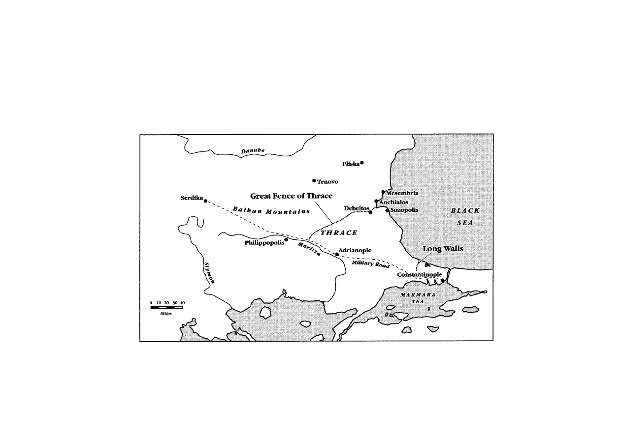
MAP 4
THE BALKAN AREA IN THE EARLY MIDDLE AGES

40
PAST AND PRESENT
NUMBER
176
ditches share, apart from their huge proportions and the amount
of digging that they all involved, is intimate ties with a ruler,
whether it be Charlemagne, king of the Franks and duke of
the Bavarians, Offa, king of Mercia, Khan Omurtag, or the
more shadowy Danish potentates who preceded King Godfrid.
Construction of the great fosses happened at roughly the same
time, in that ‘long’ eighth century during which central control,
the assertion of rulers’ authority, or state formation, all found
new means of expression. Early medieval kings and khans had
enormous difficulty in taxing their subjects and did not even
attempt to monopolize violence, but they proved highly creative
in devising other ways to obtain respect for their authority and
to impart a local efficacy to their will.
62 This is surely the best
context within which to understand the ditches. Digging ditches
or, to be more exact, having others dig ditches, was far too
important to be overlooked by rulers whose capacity to coerce
and to build support and consensus was always fragile, and open
to question. Ditches were a project the ruler defined and whose
execution he organized. Digging was a task over which thousands
of peasants could be asked to sweat and toil, and for which their
lords would allocate time. For these reasons, during the eighth
and ninth centuries the strategic qualities of the ditches, their
engineering, siting, defensibility, even their completeness, were
not as relevant as the act(s) of power which digging the ditches
made possible. For the same reasons, the accuracy of the dykes’
location at the very point where a claim to sovereignty ended
was a secondary consideration. It was not the finished product —
the ditch as artefact which scholars contemplate today — that
most concerned the powerful in the early Middle Ages. Rather,
it was the event of construction that mattered.
If the actual excavation — the
histoire e´ve´nementielle of ditch
digging — was the deeper purpose of the grand earth-moving
projects, then the details of their construction take on significance
and deserve analysis. Such an analysis suggests how work on this
scale could affect early medieval societies. It should be borne in
mind that a modestly motivated and simply equipped human
62 Rosenwein and Innes suggest ways of re-evaluating early medieval rulership
without modern statist expectations: Barbara H. Rosenwein,
Negotiating Space: Power,
Restraint and Privileges of Immunity in Early Medieval Europe (Ithaca, 1999), 6–8,
12–14; Innes,
State and Society in the Early Middle Ages, 5–7, 9–11. Roman statist
expectations suited early medieval rulers better.

41
DIGGING DITCHES IN EARLY MEDIEVAL EUROPE
excavator seldom shifts more than 1.5 cubic metres of earth in a
working day of digging.
63 This means that a huge amount of
manpower and a considerable number of hours must have been
invested in each of the early medieval excavation projects. In the
case of the Karlsgraben, for which contemporary Frankish sources
indicate how much time was spent on digging, a calculation of
the volume of soil which was moved out of the ditch and onto
the two high mounds parallel to it implies that between 4,700
and 6,000 diggers toiled for Charlemagne during the autumn of
793.
64 A very ingenious use of the early tenth-century ‘Burghal
Hidage’ has permitted an estimate of the number of hides at the
disposal of Offa (more than 150,000), and therefore of the number
of diggers he might rely upon (many thousands) and the amount
of their time that he demanded (two springs).
65 Similar calcula-
tions of the quantity of earth which was shifted in Thrace and
Jutland, together with considerations of the digging styles and the
unitary design of each dyke (which suggest rapid completion for
both projects), leave little doubt that the organizers of these
ventures also mobilized thousands of workers.
66
Nor did the work entailed in digging ditches on this scale end
when the first construction effort had subsided. The monumental
63 Caesar, Gallic War,
V
. 42, claimed a three-mile trench, with a rampart three
metres high, could appear in three hours, but surely this is just another reflection of
his famous ‘celeritas’. Brian Hobley, ‘An Experimental Reconstruction of a Roman
Turf Rampart’,
Roman Frontier Studies, 1967 (Tel Aviv, 1971), 28, writing from
experience, noted that efficiency in digging was hampered by concentrating too much
manpower into a small area (he used British convicts, ‘on loan’ from a local jail, to
erect a model rampart). Soil type, weather, availability of cartage and supplies are
some factors affecting how fast and how much one digs. Vulpe saw Romanian diggers
in the 1930s move 1.5 cubic metres of soil every eight hours, on average: Radu Vulpe,
Le Vallum de la Moldavie infe´rieur et le ‘mur’ d’Athanaric (The Hague, 1957), 49.
64 If the Fossa Carolina had been completed from Altmu¨hl to Rezat, at least 750,000
cubic metres of earth would have been shifted. As the banks of the Fossa are very
high, the work was especially difficult and labour-intensive, so a labour force of six
thousand is likeliest. See Hofmann, ‘Fossa Carolina’, 446.
65 Hill, ‘Construction of Offa’s Dyke’, 141–2; Richard Hodges, The Anglo-Saxon
Achievement (London, 1989), 144; Wormald, ‘Age of Offa’, 122, speaks of ‘tens of
thousands’. On the Burghal Hidage, see Nicholas Brooks, ‘The Administrative
Background to the Burghal Hidage’, in David Hill and Alexander R. Rumble (eds.),
The Defence of Wessex: The Burghal Hidage and Anglo-Saxon Fortifications
(Manchester, 1996).
66 For considerations on the large size of the workforce, wisely without precise
numbers, see Rasˇev,
Starobalgarski Ukreplenija, 124–5; Rasˇo Rasˇev, ‘Zemlenata
Ukrepitelna Sistema na Parvolo Balgarsko Carstvo’,
Pliska-Preslav, ii (Sofia, 1981),
102; Axboe, ‘Danish Kings and Dendrochronology’, 221; Andersen, ‘Das Danewerk
als Ausdruck’, 10. For examples of large-scale, labour-intensive projects in the 700s,
(cont. on p. 42)

42
PAST AND PRESENT
NUMBER
176
trenches needed maintenance just as drainage ditches do. The
effects of rain, wind, root growth, and animals’ activities could
be disastrous if they were not countered. In the seventh century
Isidore of Seville knew this well, and cited certain African and
Spanish earthworks as marvels because of their exceptional endur-
ance without upkeep.
67 Of course not every furrow was built to
last, or with the expectation that maintenance would be available,
but the monumental dykes in question here were not made as
ephemera. The best evidence that the rampart designers built to
last comes from Denmark, for the Danevirke had extensive sec-
tions with a turf shell overlying the bank of fill removed from
the ditch, a refinement intended to give the dyke greater solidity.
68
Also, the berms (features which normally offered attackers secure
footholds across the ditch, and which, therefore, were militarily
ill-advised) are explicable as attempts to control erosion and run-
off, and to impart more durability to the ditch-sides and banks.
Likewise the form of the ditches, with sloping sides, offered
increased strength to the structure at the expense of defensibility
(which flat-bottomed, vertical-sided ditches improve).
69 But even
the most cunning ditches silted up and soon filled with detritus
if not cleaned out; late antique Roman fighters recognized this
problem and sought a solution by obliging the local population
to clear town moats in anticipation of sieges.
70 Danish and German
(n. 66 cont.)
see Theophanes,
Chronographia,
AM
6258 (ed. C. de Boor, i, Leipzig, 1883, 440),
with a total of 6,900 workers, including specialized craftsmen; Eigil,
Vita Sturmi
Abbatis Fuldensis,
XXI
, in
Die Vita Sturmi des Eigils von Fulda: Literarkritische-
historische Untersuchung und Edition, ed. Pius Engelbert (Marburg, 1968), 156.
67 Isidore of Seville, Etymologiae,
XV
. 9. 5.
68 On the turf, see Andersen, ‘Das Danewerk als Ausdruck’, 191, 195; Stark,
Haithabu–Schleswig–Danewerk, 119. Jankuhn, Haithabu, 72–3, records the multiple
restorations of the Danevirke after ditch-clogging and mound-collapse. For comparat-
ive data on weathering, see Brian Hobley, ‘A Neronian-Vespasianic Fort at “The
Lunt”, Baginton, England’, in Eric Birley, Brian Dobson and Michael Jarrett (eds.),
Roman Frontier Studies, 1969 (Cardiff, 1974), 79–81. Hooke notes that, since most
dykes known from texts are no longer discernible, they must have been perishable,
and subsided as soon as their perceived utility ended: Hooke,
Anglo-Saxon Landscapes
of the West Midlands, 255. Cane claims Wat’s Dyke was ‘not planned to last’: J. Cane,
‘Excavations on Wat’s Dyke at Pentre Wern’,
Shropshire Hist. and Archaeology, lxxi
(1996), 18–19.
69 Napoli, Recherches sur les fortifications line´aires romaines, 7–9, considers ditch-
and-bank stability, and figure 1 offers a valuable typology of ditch shapes (11).
70 Ammianus Marcellinus, Rerum Gestarum Libri,
XXIX
. 6. 11, describes the ‘obrutas
fossas’ of Sirmium. He did not specify that Probus, the praetorian prefect during a
Quadi insurrection there, made the Sirmians do the work, but see
Codex Theodosianus,
XI
. 17. 4.

43
DIGGING DITCHES IN EARLY MEDIEVAL EUROPE
sources, which furnish the clearest evidence of the use of early
medieval dykes, suggest that times of crisis were the commonest
occasions for restoration and repair work on them: war or fear
of it provided rulers with the pretext to mobilize crews of
labourers on the Danevirke.
71 But by the 1200s Denmark’s kings
charged communities near to the Danevirke, in North Friesland,
the North Sea islands, and the coastlands of Schleswig-Holstein
with its regular upkeep; so such structures could become an
ongoing burden for diggers, as well as an ongoing means of
commanding labour for kings.
72 There is no evidence that
Charlemagne planned regular dredging of his canal, nor that the
upkeep of the Erkesia or of Offa’s Dyke preoccupied the designers
of those structures, but each of these trenches would have
required maintenance if they were to remain standing. Also, in
each case, whether occasional or at regular intervals, repairs
provided the opportunity of conscripting workers. Monumental
ditches, in other words, could become a long-term commitment
for those wielders of digging tools unlucky enough to live close by.
Despite northern Europe’s pedological stability, early medieval
Europe’s earth was not static. Earth
could move on its own,
eroded by heavy rain or gusts of wind or, even more marvellously
when supernatural forces intervened, piling up overnight to
form an embankment, as happened near Magdeburg in 822.
73
Nevertheless, human cultural interventions contributed most to
making earth change place during the early Middle Ages, for
Europe’s was a soil-moving society. Although enormous excava-
tions like the ones discussed here remained exceptional, they
traversed territories whose inhabitants were accustomed to shift-
ing soil around, sometimes large quantities of it.
Ditch-digging was, after all, an everyday agricultural operation,
one which the manual for farm overseers of tenth century
England,
Gerefa, advised should be done on a regular, seasonal
71 Saxo, Gesta Danorum,
X
. 3,
XIII
. 8. 5 (ed. Olrik and Ræder, i, 272, 359), places
rebuildings in war contexts. Thietmar of Merseburg,
Chronicon,
III
. 6 (ed. Holtzmann,
104), says ‘ad defensionem patriae parata est [foveam]’ in 975, with Otto II looming
on the horizon.
72 Liber Census Daniae: Kong Valdemar den Andens Jordebog, ed. O. Nielsen
(Copenhagen, 1873), 15, 17, 19. This rare Danish evidence of how work on the
Danevirke might be organized dates to 1231.
73 Annales Regni Francorum, s.a. 822 (ed. Kurze, 157).

44
PAST AND PRESENT
NUMBER
176
basis.
74 Small trenches carried water away from one field or onto
another one, or channelled run-off into streams. Earthen banks,
the product of digging, occasionally separated fields or sur-
rounded woods, especially in England.
75 But these were small-
scale digging operations, compared to an Erkesia or a Danevirke.
Somewhat grander were certain excavations carried out in early
medieval Europe in order to improve navigability. The seventh-
century Byzantine stronghold of Heraclea, in the marshy zone
north of Venice, boasted a watercourse created by straightening
a natural channel, which clearly required a lot of digging.
76
Slightly later were the surprisingly ambitious canal constructions
of early medieval Denmark. Though inexplicable as improve-
ments to navigation, these still involved much digging.
77 In both
western England and southern Denmark there are also several
short dykes, unrelated to Offa’s Dyke or the Danevirke — further
evidence of the desire to dig up the earth, even if on a scale more
modest than that of the great dykes.
78 In the early Middle Ages,
earthworks sometimes encircled settlements, as at the Bulgar
capital, Pliska, or Hamwic (Southampton), or Hedeby.
79
Another occasion for turning over the soil was the disposal of
the dead. A few prominent people received burial in barrows or
74 Die Gesetze der Angelsachsen, ed. F. Liebermann, 3 vols. (Halle, 1903–16), i, 454
(
Gerefa,
XII
), suggested that scooping out ditches was one of the occupations under-
taken in the spring.
75 On earthen banks, see Oliver Rackham, The History of the Countryside (London,
1986), 98–100; Rackham, ‘Trees and Woodland in Anglo-Saxon England’, 9; Hooke,
Anglo-Saxon Landscapes of the West Midlands, 255–60. See also Isidore, Etymologiae,
XV
. 13. 2.
76 Pierluigi Tozzi and Maurizio Harari, Eraclea Veneta: immagine di una citta` sepolta
(Parma, 1984), 101–3.
77 Axboe, ‘Danish Kings and Dendrochronology’, 222, 241; Olsen, ‘Royal Power
in Viking-Age Denmark’, 29–31.
78 Randsborg, Viking Age in Denmark, 48; Axboe, ‘Danish Kings and
Dendrochronology’, 223–4; Olsen, ‘Royal Power in Viking-Age Denmark’, 28; Fox,
Offa’s Dyke, 114; N. P. Brooks, ‘England in the Ninth Century: The Crucible of
Defeat’,
Trans. Roy. Hist. Soc., 5th ser., xxix (1979), 10–11.
79 Harald Bluetooth’s elegant earthen forts in North Denmark were ‘pretty
impractical’: see Roesdahl, ‘Prestige, Display and Monuments in Viking Age
Scandinavia’, in Galinie´ (ed.),
Les Mondes normands, 22–3. On Hedeby, see Randsborg,
Viking Age in Denmark, 72; Jankuhn, ‘Die Befestigungen um Haithabu’; Sawyer and
Sawyer,
Medieval Scandinavia, 147. Brisbane thinks Hamwic’s barrier was indefens-
ible: Mark Brisbane, ‘Hamwic (Saxon Southampton): An Eighth-Century Port and
Productive Centre’, in Richard Hodges and Brian Hobley (eds.),
The Rebirth of Towns
in the West (London, 1987), 103. On Pliska, see Rasˇo Rasˇev, ‘Zemlenoto Ukreplenie
na Pliska’,
Pliska-Preslav, iv (Sofia, 1985); Rasˇo Rasˇev, ‘Pliska: The First Capital of
Bulgaria’, in A. G. Poulter (ed.),
Ancient Bulgaria, 2 vols. (Nottingham, 1983), ii, 259.

45
DIGGING DITCHES IN EARLY MEDIEVAL EUROPE
big piles of earth (tumuli), both of which necessitated much
diligent digging: Sutton Hoo’s mound is only the most famous.
As the first millennium waned, this practice became less common,
and even in Late Antiquity people consistently preferred to
recycle prehistoric barrows rather than make new ones: but still
much soil changed place.
80 In Bulgaria, mounds large enough for
their creation to have occupied more than the immediate family
of the deceased were in use quite late, and the largest and most
famous burial mounds of Denmark, at Jelling, date to the mid
tenth century: they clearly kept many workers busy for a long
time. The mysterious, perhaps cosmological ‘toumba’ created by
Khan Omurtag to mark the geometric midpoint between two
meaningful places — khanal residences — was not a tomb but
was ‘magnificent’ enough that it, too, must have required the
labour of many diggers.
81
In sum, from these exalted religiously motivated monuments
to the humblest homespun drainage ditch, early medieval people
had many occasions to turn over the earth, excavate it, shape it,
and reconfigure it according to their needs. Digging was weari-
some but not technically demanding work. The equipment it
required was available to most; many were agriculturalists for
whom hoes, spades, baskets, carts, and beasts of burden were
familiar, even if the specialized iron digging tools which
Charlemagne’s army on campaign in the Elbe region expected to
have on hand, were not widely available.
82 Unlike other types of
construction work, which call for specialists and special materials,
it was an optimal occupation for the ordinary workforce. It also
80 Jankuhn, Haithabu, 87–8; Sims-Williams, Religion and Literature in Western
England, 65–75, 343; Dark, From Civitas to Kingdom, 116; Magdalena S. Midgley,
The Origin and Function of the Earthen Long Barrows of Northern Europe (Oxford,
1985); Ivan Dujcˇev, ‘Le Proble`me des tumuli et des sanctuaires slaves en Bulgarie’,
in his
Medioevo bizantinoslavo, 3 vols. (Rome, 1965–71), iii; R. van der Noort, ‘The
Context of Early Medieval Barrows in Western Europe’,
Antiquity, lxvii (1993).
81 Die protobulgarischen Inschriften, ed. Besˇevliev, 247, no. 55, with useful comment-
ary (255–60). Omurtag called the tumulus ‘panphumon’, the same term that he
applied to his palaces. There
are a few instances in Anglo-Saxon and Bulgar culture
where earth has religious overtones rather like the Roman Tellus, but earth-moving
does not seem a sacral activity.
82 This makes dykes unlike pyramids, to which they sometimes are compared (see,
for example, Hart, ‘Kingdom of Mercia’, 56), and unlike royal residences or Byzantine
aqueducts, because their construction did not call for specialized craftspeople or
building materials. Charles’s letter to a retainer, datable to the period of the Danish
campaigns, asks that carts contain ‘fosorios, palas ferreas et cetera utensilia que in
hoste sunt necessaria’:
Capitularia Regum Francorum,
LXXV
(ed. Alfred Boretius,
MGH, Legum Sectio II, i, Hanover, 1883, 168).

46
PAST AND PRESENT
NUMBER
176
did not call for great investment on the part of the powerful.
Perhaps for these reasons they espoused it, in its most monu-
mental form.
For the immensity of the Danevirke, of Offa’s Dyke, of the
Karlsgraben, and of the Erkesia made them exceptional. No
matter how much soil was shifted in early medieval communities,
these structures represent a gigantic, concentrated amount of
work, unequalled by other diggings. How rulers extracted this
extraordinary effort from such large numbers of their subjects is
not clarified even by the few texts that are contemporary with
the work and describe the actual digging. In fact, who did the
digging was not a question asked by early medieval writers.
However, obtaining corve´e labour was one of their prerogatives
which eighth-century rulers took seriously. Indeed, at a time
when the requirement of labour services by landlords was on the
rise, rulers appear to have become more exacting on the muscle
power of their subjects, and to have asked for more bridge
maintenance and other unremunerated construction work than
had been usual.
83 Although much of the evidence for corve´es in
‘public works projects’ dates from after 850, later than the
excavations dealt with here, it is clear that it was no innovation
at that time. Indeed, it seems that when Mercia’s eighth-century
kings affirmed their right to make subjects who owned land
provide labour on bridges and fortifications, they were only being
more vigorous than their predecessors. This right was older, but
had tended to lie dormant. Strident ecclesiastical complaints
against this kind of imposition might suggest such exactions were
not yet customary, and that recipients of royal gifts of land had
yet to digest the fact that such gifts came with strings attached.
Indeed, Mercian diplomas from Offa’s reign are the earliest extant
ones explicitly to reserve the triple royal prerogative (the
trimoda
necessitas) and spell out that gift lands were not immune from
obligations to supply kings with three kinds of labour service.
Yet there are so few surviving earlier charters of any sort that
we may wonder whether what was new was the intransigence of
Offa and his predecessor Aethelbald, rather than the right itself.
In the eighth century, royal grants of land, and the consequent
need to specify which royal rights remained in force on granted
land, gained novel prominence. The need to reiterate the fact
83 Wendy Davies, ‘On Servile Status in the Middle Ages’, in M. T. Bush (ed.),
Serfdom and Slavery (London, 1996), 234–5.

47
DIGGING DITCHES IN EARLY MEDIEVAL EUROPE
that no one was exempt from corve´es for maintenance work on
infrastructures shows how unpopular this obligation was in all
sectors of Anglo-Saxon society, and how tempting it was, for
those who could, to forget about it unless frequently reminded.
But by the later ninth century Anglo-Saxon kings expected the
burden for the upkeep of bridges and boroughs to rest on local
landowners’ shoulders.
84
Elsewhere in the Carolingian world similar requirements
existed. Constructing the famous Leonine wall built in the
mid-800s around St Peter’s in Rome was the responsibility of
rustics recruited from nearby papal estates, with each community
being responsible for a section of wall and the inscription to
commemorate its efforts.
85 Mauerbaupflicht (wall-building duty),
of which there is an interesting example from Carolingian Worms,
was imposed on villages around the metropolis, with groups of
villages obligated to build and patch up specific stretches of the
town’s defensive circuit.
86 Something similar appears to have
transpired in West Francia in the mid ninth century. The
Annals
of St Bertin describe the almost feverish pace at which Charles
the Bald conducted his pet project of erecting fortifications ‘of
stone and wood’ at Pıˆtres in the 860s. According to this account,
Charles surveyed the site himself, then assigned obligations to
work on specific measured lengths of wall to the inhabitants of
his realm in proportion to their wealth. Naturally, most of those
84 W. H. Stevenson, ‘Trimoda Necessitas’, Eng. Hist. Rev., xxix (1914); Abels,
Lordship and Military Obligation, 52–7, 77; P. H. Sawyer, From Roman Britain to
Anglo-Saxon England (New York, 1978), 109; Nicholas Brooks, ‘The Development
of Military Obligation in Eighth- and Ninth-Century England’, in Peter Clemoes and
Kathleen Hughes (eds.),
England before the Conquest (Cambridge, 1971), 69–76, 82–3;
Brooks, ‘Administrative Background to the Burghal Hidage’, 129; C. Warren Hollister,
Anglo-Saxon Military Institutions (Oxford, 1962), 59–62; Fox, Offa’s Dyke, 79–81.
For Boniface’s scandalized letters, see Boniface,
Epistulae,
LXXIII
,
LXXVIII
, in
Die
Briefe des heiligen Bonifatius und Lullus (ed. Michael Tangl, MGH, Epistolae Selectae,
i, Hanover, 1916, 152, 169); Sims-Williams,
Religion and Literature in Western
England, 136.
85 For the inscriptions, see Liber Pontificalis,
CV
. 68–9 (ed. Duchesne, ii, 123, 137
n. 47; i, 518 n. 52). Sheila Gibson and Bryan Ward-Perkins, ‘The Surviving Remains
of the Leonine Walls’,
Papers Brit. School at Rome, xlvii (1979), 31–3, mention the
unpopularity of the obligation among peasants, and the fact that some supplies must
have been provided by the project’s patrons.
86 See the ‘Wormser Mauerbauordnung’, Quellen zur Geschichte der Stadt Worms,
ed. Heinrich Boos, 4 vols. (Berlin, 1886–95), iii, 223–4; Alfons Scha¨fer, ‘Mauer-
baupflicht fra¨nkische Ko¨nigsleute zu Ladenburg und an der karolingerzeitlichen
Ringwallanlage “Heidenlo¨cher” bei Deidesheim’,
Zeitschrift fu¨r der Geschichte der
Oberrheins, lxxiv (1965).

48
PAST AND PRESENT
NUMBER
176
thus taxed would send ox carts and labourers rather than work
themselves. Yet the
Annals leave little doubt that considerable
numbers of workers could be obtained in this way, despite the
inevitable attempts to prevaricate (Charles could not get people
near Pıˆtres to work on local bridges and, in order to get the job
done, he had to recruit from those who had arrived from further
afield to build fortifications on the Seine against Norse raids).
87
The same military crisis which justified Charles the Bald’s
demands for his subjects’ co-operation on his building projects
in this case seems also to have justified his subjects’ evasion of
such work, giving them the excuse that the times were too unsafe
for unarmed work parties to be abroad. This is not quite the
same image of relentless commitment and unfailing obligation to
work on public service tasks which contemporary laws display;
though of course the laws present the world as Carolingian rulers
would have liked it to be, and the capitularies mention the
(unpopular) obligation of some peasants to load marl and trans-
port it by cart to royal centres.
88
These different kinds of evidence all suggest that during the
‘long’ eighth century, rulers could demand construction work
from their subjects without having to recompense them. It seems
that on some occasions, at least, rulers succeeded in obtaining
what they wanted, and that episodically they could muster many
workers. Despite the apparent ability of Charles the Bald to
gather workers from remote places at a central location to work
for him, the evidence also suggests that corve´es were imposed
and carried out locally. The major earth-moving operations of
the eighth and ninth centuries would therefore have had a pre-
dominantly local impact — usually on the rural communities,
through whose territory the ditches ran, whose labour the ditches
absorbed, and for whom the event of ditch-making was most
significant. The construction of the ditches is best understood in
a localized, regional landscape, not only because the catchment
area of the workforce involved was local and regional, but
also because each region of early medieval Europe in which a
87 Annales Bertiniani, s.a. 862, 865 (resistance to bridge work), 866, 868, 869 (ed.
G. Waitz, MGH, Scriptores Rerum Germanicarum in Usum Scholarum, Hanover,
1883, 58, 79, 82, 96, 98). See Nicholas Brooks, ‘European Medieval Bridges’, in his
Communities and Warfare, 700–1400 (London, 2000).
88 For example, the ‘Edict of Pıˆtres’,
XXIX
, in
Capitularia Regum Francorum,
CCLXXIII
. 29 (ed. Alfred Boretius and Victor Krause, MGH, Legum Sectio II, ii,
Hanover, 1897, 323). This involved the kinds of work also required by ditch-digging.

49
DIGGING DITCHES IN EARLY MEDIEVAL EUROPE
monumental trench lay had peculiarities which gave each ditch a
slightly different significance.
For instance, the land across which the Great Fence of Thrace
extends was a recent addition to the khans’ domains. It was
inhabited by a heterogeneous population whose culture was Greek
and Slavic. As the khans seldom required military service from
non-Bulgars (except in great emergencies), what they could best
extract from those was logistical service. The rural inhabitants of
northern Thrace, most of whom were not Bulgars, are the likeliest
candidates for doing the digging necessary for an Erkesia. The
task of supervising the diggers, and ensuring that they carried
out the work as required, would fall to the Bulgar troops and
khanal officials.
89 In this case digging the ditch became a moment,
however brief, of khanal triumph. It was a fleeting episode during
which the khan was able to appropriate the work and resources
of his subjects, both Bulgar and others, on a scale unequalled by
even the most ambitious military campaigns. Digging the Erkesia
would thus have been an enactment of the social and ethnic
relations upon which khanal ideology rested. The enactment took
place in a contested territory, and required the participation of
numerous people for whom the khan’s overlordship was new and
alien. These circumstances added to the usefulness of the exercise
of digging the long furrow.
When Charlemagne’s host descended on the valley of the
Altmu¨hl with the intention of opening a passage for its waters to
the Rezat, a tributary of the Regnitz that flows into the Main
near Hallstadt, Bavaria had not been part of the Carolingian
hegemony for long. Indeed, under its enterprising Duke Tassilo
the independent duchy of Bavaria had given Francia much to
worry about until 788. Only with the deposition of the local duke,
89 Omurtag was sensitive to ethnicity, as evinced from Die protobulgarischen
Inschriften, ed. Besˇevliev, 191, no. 41. The Byzantine custom of settling eastern
Christians in Thrace (attested by Theophanes and Patriarch Nikephoros) furthered
the cultural mixing: see Ostrogorski,
History of the Byzantine State, 192–5; Dimitur
Angelov,
Die Entstehung des bulgarischen Volkes (Berlin, 1980), 97–8. Hostages and
prisoners added further heterogeneity. On the Greek speakers of the area, see Mark
Whittow,
The Making of Byzantium (London, 1996), 273–4, 279–81. The classic
work by Ivan Dujcˇev, ‘Protobulgares et slaves’, in his
Medioevo bizantinoslavo, i,
discusses Bulgar–Slav relations. In emergencies, as in
AD
716 or 812, the khans did
summon Slavic soldiers, but otherwise recruited Bulgars: Besˇevliev,
Die protobulgar-
ische Periode der bulgarischen Geschichte, 244, 280, 347–54; Browning, Byzantium and
Bulgaria, 132–5. A papal text of
AD
866 suggests Bulgar levies were unenthusiastic,
and the penalties inflicted on foot-draggers shocked the pope: Nicholas I,
Epistulae,
XCIX
(ed. Perels, 579, 582).

50
PAST AND PRESENT
NUMBER
176
the assumption of his title and prerogatives by the king of the
Franks, and the introduction there of Frankish institutions and
magnates did the incorporation of this new province of the nascent
Carolingian empire begin. Thus the construction of the canal in
793 was an anomalous event for the Bavarians who witnessed it,
both because of its inherent nature (Tassilo, whom Charlemagne
exiled to a monastery, tried many imaginative things, but did not
dig ditches), and because of who inspired it, namely a new, as
yet untested authority. As with most places annexed by the
Carolingians, the transition into the Frankish fold went smoothly
and there was much intermarriage of Franks and Bavarian land-
owners.
90 Still, in 793 in northern Bavaria the people who had so
recently attained supremacy had use for exemplary exercises of
power such as making others dig ditches. Neither Charlemagne’s
immediate followers nor his household troops were numerous
enough to make the great trench in a few months of autumn, so
conscripted peasants, and perhaps captives from the Avar cam-
paigns were most probably responsible for the bulk of the work.
91
Some of the manpower must have come from former ducal farms.
Other diggers probably came from neighbouring settlements
where other landlords held sway.
92 The ownership of land did
not change much under the Carolingians, but the peasants’ pres-
ence at the excavation site testified to a new capacity of the dukes
(and Frankish kings) to win compliance from many for the new
90 This is the conclusion of Kathy Roper-Pearson, Conflicting Loyalties in Early
Medieval Bavaria: A View of Socio-Political Interaction, 680–900 (Aldershot, 1999).
See also Stuart Airlie, ‘Narratives of Triumph and Rituals of Submission:
Charlemagne’s Mastery of Bavaria’,
Trans. Roy. Hist. Soc., 6th ser., ix (1999), 101–3,
116; Collins,
Charlemagne, 77–87.
91 Hofmann, ‘Fossa Carolina’, 447, claims Frankish troops and Avar prisoners did
the digging. It is more likely to have been the latter. Early Roman legionaries had
dug ditches, but by Late Antiquity digging, especially of trenches unrelated to their
forts, was one of the ‘sordida munera’ that troops resented: Valens’ ability to have
troops make ramparts without mutiny was a feat (Themistocles,
Oration,
X
. 12), in
contrast to earlier evidence: for example,
Anne´e Epigraphique (1983), no. 927. The
task, thrust upon civilians, created attempts to avoid it:
Codex Theodosianus,
XI
. 17.
4,
XV
. 1. 34,
XV
. 1. 49. See Nicholas Brooks, ‘Church, Crown, and Community:
Public Work and Seigneurial Responsibilities at Rochester Bridge’, in Timothy Reuter
(ed.),
Warriors and Churchmen in the High Middle Ages (London, 1992), 16. The
project enabled Charles to use new rights and resources from the royal estate at
Weissenburg: Hofmann, ‘Fossa Carolina’, 449.
92 Population was low in the area of the ditch in the early Middle Ages, judging
from the slim archaeological traces. A twelfth-century source represented ‘a multitude
of Bavarians and Franks and Swabians’ (i.e. ethnic groups) making the ditch:
Auctarium Codicis Monacensis (ed. W. Wattenbach, MGH, Scriptores, xiii, Hanover,
1881, 237).

51
DIGGING DITCHES IN EARLY MEDIEVAL EUROPE
order of things.
93 In this freshly conquered area, the Karlsgraben
gave Charlemagne a chance to exercise his ruler’s rights and
to test the loyalty of Tassilo’s former followers by demanding
their labourers’ work. For a ruler as frenetically itinerant as
Charlemagne was before 800, the three or four months of immob-
ility in a remote corner of rural northern Bavaria in 793 were
well worth while, even if they reduced his ability to disseminate
the royal presence and produced no canal by which to penetrate
Avar lands. Those months gave the new Frankish lord the oppor-
tunity to choreograph an event in which Bavarian potentates and
subalterns had to show obedience and support. They also allowed
Charlemagne to leave his mark on the countryside in the form of
the vestigial trench still visible at the hamlet of Graben.
94
The eighth century in general, and Offa’s later reign in particu-
lar, were successful times for the Mercian monarchy. During the
700s Mercia grew in power and status until it overshadowed the
other kingdoms of Britain. This hegemony had its setbacks, and
was always contested by other Anglo-Saxon kings, but Offa was
by far the most successful English ruler of his age. Nevertheless,
like other English rulers, Offa depended heavily on the consent
and support of magnates. His willingness to give the loyal ones
gifts of farmland (a precious commodity), betokened his need for
friends and allies. In this context of ongoing, much-reaffirmed
mutual dependence, digging Offa’s Dyke had special resonance.
As was noted earlier, Offa was one of the first English rulers to
bind land ownership tightly to the duty of building or rebuilding
a specified length of fortification (earthworks, for the most part).
If, as David Hill plausibly suggested, Offa’s Dyke was built using
the same recruitment methods that Mercia’s rulers theoretically
applied to the smaller, more defensible town ramparts in the
realm, then Mercia’s landowners would have suffered a consider-
able loss of manpower, supplies, and time which could have been
devoted to agriculture.
95 Offa demanded and, judging from the
93 The disapproval of the ‘big dig’ mentioned in the Einhard Annals may stem from
Charlemagne’s inclusion of churches among the landlords whose workforce he
co-opted.
94 Geertz acutely noted kings’ desire to travel their countryside and ‘mark it like
some wolf or tiger spreading his scent through his territory’: Clifford Geertz, ‘Centers,
Kings, and Charisma: Reflections on the Symbolics of Power’, reprinted in Sean
Wilentz (ed.),
Rites of Power (Philadelphia, 1985), 16. Charlemagne’s retinue was in
need of such edification after a major rebellion.
95 Welsh subjects may have been forced to dig, but see Hill, ‘Construction of Offa’s
Dyke’, 141–2; Brooks, ‘Development of Military Obligation’, 84. Abels,
Lordship and
(cont. on p. 52)

52
PAST AND PRESENT
NUMBER
176
surviving remains, received the sacrifice of resources and work
on an unprecedented scale. To the extent that Mercians particip-
ated, therefore, digging the long trench through the western
borderlands was an important, if momentary, imposition of norm-
ally dormant royal rights on Mercia’s aristocracy and their rural
dependants. With respect to the relationships among the power-
ful, digging Offa’s Dyke was a short but sharp and instructive
actualization of the kings’ claims over men whom they could not
afford to alienate, but whose rural workers they nevertheless
appropriated for a short time.
No single Danish lord is known to have enjoyed supremacy
over the Jutland peninsula in the early 700s, when the earliest
linear earthwork was built near the Eider river. By 800 outside
observers perceived a unified state under Godfrid, but the earlier
phase of Danevirke digging cannot be assigned to a similar ruler.
Still, this second phase of construction, which the Frankish chron-
iclers associated with a fearsome enemy, indicates that major
ditch-and-bank features came out of royal initiatives in this
period. It is therefore feasible for the earlier Danevirke to belong
in a context of aggrandizing chiefdoms and state formation. In
each of its first millennium guises, the Danevirke gave overbear-
ing rulers a task through which they could co-opt unusual num-
bers of people. The dyke was surely the biggest ‘public works
project’ in early Danish history and whoever organized its con-
struction, whether in the early 700s or early 800s or 960s, demon-
strated unprecedented control over manpower, equipment, and
logistics.
96
The extant sources do not provide many details about this
organizational effort, but the
Royal Frankish Annals maintain
that, upon returning to Denmark from a successful campaign in
Saxon and Obodrite lands, Godfrid’s commanders received a
(n. 95 cont.)
Military Obligation, 45–6, 52–3, points out that the third ‘necessitas’, military service,
appeared later than the other two: bridge work and fortification repair. Brooks,
‘England in the Ninth Century’, 19, notes that only with universal conscription in
the 1900s did English kings’ appropriations of subjects’ labour reach these levels.
What a burden building Offa’s Dyke could be was shown on a BBC television
programme where none of the companies involved in British public works projects
could be persuaded to attempt the reconstruction of something like the dyke: K. Smith,
Free is Cheaper (Worcester, 1988), 26. My thanks to Luisa Squatriti for this reference.
96 On early Danish state formation, Hedeager, ‘Kingdoms, Ethnicity and Material
Culture’; Axboe, ‘Danish Kings and Dendrochronology’, 217–38; Simon Coupland,
‘From Poachers to Gamekeepers: Scandinavian Warlords and Carolingian Kings’,
Early Medieval Europe, vii (1998).

53
DIGGING DITCHES IN EARLY MEDIEVAL EUROPE
share of the task of construction from an impatient king. The
annalist did not claim that the wily leader ordered his combat-
tested, loyal retainers to take up spades and dig the trench,
however; since Late Antiquity at least, that was work warriors
did not like to do. More vaguely, the Carolingian writer said that
different units of the army had responsibility for ensuring that a
given sector of the ‘vallum’ was finished. The implication is that
the warriors’ work was enforcement of the king’s will on the
locals, with peasants doing the digging.
97 Since no such account
of the construction of the first Danevirke exists, we cannot know
how it was created. Yet later sources, like the
Liber Census Daniae
and the legendary account of how the Danes created their
Danevirke by Sven Aggesen, suggest ordinary local civilians,
inspired or obligated by kings, built the structures.
98 Each of the
Danevirke’s pre-1000 construction phases took place when lead-
ership of the Jutlanders was contested, whether by the various
chiefs of the early eighth century, by Godfrid’s Carolingian-
sponsored relatives, or by the many lords whom overseas expedi-
tions had enriched in the tenth century.
99 The immediate semiot-
ics of the large effort represented by digging the dykes would
reverberate among the various Danish leaders
not involved in it.
Indeed, a ditch-digging lineage was established, with Godfrid
being the moral perpetuator of the unknown first creator of the
fosse and Harald Bluetooth, the king behind the tenth-century
overhaul of the structure, as the culmination of the tradition. For
97 Annales Regni Francorum, s.a. 808 (ed. Kurze, 126): ‘Ibi per aliquot dies moratus
limitem regni sui, qui Saxoniam respicit, vallo munire constituit, eo modo, ut ab
orientali mari sinu, quem illi Ostarsalt dicunt, usque ad occidentalem oceanum totam
Egidorae fluminis [the Eider] aquilonamlem ripam munimentum valli praetexeret,
una tantum porta dimissa, per quam carra et equites emitti et recipi potuissent. Diviso
itaque opere inter duces copiarum, domum reversus est’.
98 Liber Census Daniae, ed. Nielsen, 15, 17, 19. Sven Aggesen, Brevis Historia Regum
Dacie,
V
–
VI
, in
Scriptores Minores Historiae Danicae Medii Aevi, ed. M. Cl. Gertz, 2
vols. (Copenhagen, 1917–20), i, 108–15, gives a full account, perhaps based on oral
sources, with details of a
leve´e en masse of diggers (excluding infants and the decrepit),
pay for the indigent, and recognition that it cost much sweat. Aggesen placed construc-
tion in the mid-900s. H. H. Andersen, ‘Opus Danorum’,
Archa¨ologie in Deutschland,
ix (1992), associates the digging of the 730s with the King Ongandus who met St
Willibrord. Unverhau,
Untersuchungen zur historischen Entwicklung, 37, 41–52, stresses
that after 1100 royal fisc and rights were linked to the Danevirke.
99 On tenth-century statesmanship, see Niels Lund, ‘ “Denemearc”, “Tanmarkar
But”, and “Tanmaurk Ala” ’, in Ian Wood and Niels Lund (eds.),
Peoples and Places
in Northern Europe; Hedeager, ‘Kingdoms, Ethnicity and Material Culture’, 297–8;
Olsen, ‘Royal Power in Viking-Age Denmark’, 28; Sawyer and Sawyer,
Medieval
Scandinavia, 54–6.

54
PAST AND PRESENT
NUMBER
176
each of the rulers involved with the Danevirke, digging asserted
both primacy among their peers and rights over labourers’ time.
In the competitive and unstable politics of early medieval
Denmark, initiating, managing, and completing a massive ditch-
and-bank line was a reward in itself, regardless of whatever
(minimal) tactical benefits the embankment could deliver to the
state. By their toil, borderlanders showed allegiance or at least
compliance, while competitors received an ominous warning.
IV
If this analysis is valid, then the process of digging the dykes,
the days protracted into weeks spent patiently breaking the topsoil
and piling up the subsoil on the lip of the long trench, was as
important, at least in the early Middle Ages, as the finished dyke
after the tired labourers had gone home. Such digging mobilized
more people than any other known royal activity, in Bavaria or
Bulgaria or elsewhere. Once a trajectory had been established,
probably by tracing a furrow or by setting up a string of land-
marks,
100 the digging exercise could be justified by appeals to
ancient customs whereby certain community projects were a
shared burden that kings could ask communities to bear. Some
sort of military ‘necessity’, like a rumoured imminent invasion,
no doubt helped to render the kings’ demands more palatable in
the marginal zones where the digging occurred. In such a case
the early medieval monumental digs would have acted rather
like the ancient Roman ditches ‘made for the sake of discipline’,
trenches dug in the knowledge that they would not serve any
purpose beyond illustrating hierarchies and toughening the dig-
gers.
101 Constructing a futile barrier enacted appropriate social
relations even when no one had delusions about the dyke’s defens-
ibility or the accuracy of its positioning on the edge of a dominion.
The linear earthworks of Thrace, Jutland, Mercia, and even
the Karlsgraben in Bavaria emerge from this discussion as defining
episodes in the history of early medieval state formation. But
100 Beneath many of the sixty-eight excavated sections along Offa’s Dyke, archaeolo-
gists found a marking-out bank: Hill, ‘Offa’s and Wat’s Dykes’, 22. Fox, ‘Boundary
Line of Cymru’, 279, 286, thought outcrops also oriented the diggers.
101 Pseudo-Hyginus,
XLIX
, in
Pseudo-Hygin des fortifications du camp, ed. Maurice
Lenoir (Paris, 1979), 20, mentions ‘fossa . . . causa disciplina’ made in safe, peaceable
places by legionaries. Tacitus,
Annals,
XI
. 20. 1,
XIII
. 53, describes the desire to
prevent sloth motivating some consular excavation projects.

55
DIGGING DITCHES IN EARLY MEDIEVAL EUROPE
after the event of construction, with its attendant context of
consensus and coercion, and the acting out of political and social
roles for rulers, magnates, and peasants, the ditches lived on.
Indeed, among human structures few have the capacity of giant
dykes to survive over the
longue dure´e. The early medieval ones
are still visible, after all, obtrusive and unmistakable landscape
features even today. They were still more evident and ostentatious
when the digging was fresher, when vegetation had not yet
engulfed their slopes and rabbits and badgers had not burrowed
through them, before erosive rains had shorn off their edges and
clogged their trenches with soil washed from their flanks and
berms. As each of the dykes occupied extensively populated
terrain where agriculture had reduced the obscuring presence
of woodland, the banks caught the eye from a distance.
102
Prehistorians concerned with the emergence and use of earthen
long barrows in north-western Europe postulate that Neolithic
people’s interest in great earthworks depended on the durability
and visibility such monuments enjoyed.
103 Not only did the earth-
works orchestrate human movement around them, and thus shape
the experience of the Neolithic landscape, but by standing out in
an impermanent material world the earthen barrows also forged
a new sense of history. Both the exceptional endurance of earth-
works and their constant exposure to scrutiny created a novel
sense of time and of the community’s past. Awareness of an age-
102 Fox, Offa’s Dyke, 207, 270, thought much primeval forest occupied western
England and explained the gaps in the dyke, but Noble,
Offa’s Dyke Reviewed, 8, 31,
corrected him. On woodland in the region, see Gelling,
West Midlands in the Early
Middle Ages, 6–19; Davies, Wales in the Early Middle Ages, 11–12. Pollen samples
suggest a stable agrarian landscape: see S. P. Dark, ‘Palaeoecological Evidence for
Landscape Continuity and Change in Britain,
c.400–800’, in K. R. Dark (ed.), External
Contacts and the Economy of Post-Roman Britain (Woodbridge, 1996), 32–3, 37–8,
40–4, 46–7, 50. The equipment people used indicates an agrarian landscape in
Bulgaria: Henning,
Su¨dosteuropa zwischen Antike und Mittelalter, 35–40, 51–3;
Browning,
Byzantium and Bulgaria, 86–7; Besˇevliev, Die protobulgarische Periode der
bulgarischen Geschichte, 412–13; J. D. Howard Johnston, ‘Urban Continuity: The
Balkans in the Early Middle Ages’, in Poulter (ed.),
Ancient Bulgaria, ii, 242–3. For
the Danish landscape, see Nissen Jaubert, ‘Syste`mes agraires dans le sud de la
Scandinavie’, 81–2; Sawyer and Sawyer,
Medieval Scandinavia, 32–3, 40–1;
Randsborg,
Viking Age in Denmark, 51–2; Na¨sman, ‘Exchange and Politics’, 60.
Hedeby’s name derives from an Old Danish word for ‘heath’, again suggesting
deforestation in the eastern sector of the Danevirke. Unverhau,
Untersuchungen zur
historischen Entwicklung, 21, thinks some woods existed in the 860s, despite clear-
ances (57).
103 See Richard Bradley, The Significance of Monuments (London, 1998), 17–18,
51–3, 71–6, 161–2; Richard Bradley,
Altering the Earth: The Origins of Monuments in
Britain and Continental Europe (Edinburgh, 1993), ch. 3.

56
PAST AND PRESENT
NUMBER
176
old, ancestral presence in a landscape implied an entitlement to
local resources and a justification for local activities. But the
monuments’ implications were not static. On the contrary, the
extraordinary longevity of the earthen barrows enabled successive
generations of people to interpret the structures and use them
accordingingly. Obtrusive and enduring, earthworks are ideally
suited to an ongoing contextualization in different histories.
Perhaps for this reason early medieval people took note of the
presence of the monumental ditches dug in the eighth and ninth
centuries. As a consequence, the ditches all developed layers of
significance, added on to the raw fact of their impressive phys-
icality. Each of the earthen structures became a ‘site of memory’
for medieval people. The origins of the memory attaching to the
trenches are impossible to trace, though an early, grudging layer
of oral memorialization may well have developed among those
who did the digging. Various shreds of evidence suggest that
when people saw, wondered at, and (thankfully for historians)
wrote about the ditches, it was a triumphal memory of glorious
rulership that most tenaciously clung to these structures. The
afterlife of ditches thereby proved as useful to kings and their
states as those few months during which spades and hoes re-
designed landscapes in various corners of Europe. A parallel fate
befell China’s famous ‘Great Wall’, which has many similarities
with Europe’s post-classical diggings. Just as the Karlsgraben
became the occasion to celebrate a king’s omnipotence or chastise
his imprudence, as Offa’s Dyke came to stand for contested
versions of the past among Welsh and English, as the Erkesia
became a tribute to khans’ competence, and as the Danevirke
grew into a memorial to royal Danish ability and martial spirit,
so the ‘Great Wall of China’ has carried meanings according to
the needs of those who wrote and spoke about it. The many
minor ‘earth dragons’ of pre-Ch’in China, and the occasional
earthworks thrown up by the Ch’in’s successors, became a stone
wall under the Ming and a symbol of Chinese civilization in the
tales of both literate and illiterate people, both Chinese and others.
The mythical barrier was far more effective than the real one. In
the Chinese borderlands, and in the early medieval European
ones, the superinvestments of states bore fruit for generations
to come.
Among the early medieval rulers whose names became associ-
ated with dykes and their construction, Khan Omurtag enjoys

57
DIGGING DITCHES IN EARLY MEDIEVAL EUROPE
the distinction of having sought the identification of his rule with
the ditch himself. The Suleyman Koy inscription, an official
document carved on a pillar and probably kept at his main
residence, Pliska (close to the village of Suleyman Koy where
archaeologists found the inscription in the early 1900s), was a
permanent proclamation of his success.
104 In it the khan recorded
how he had ‘established’ the border with the Byzantines.
Although the border as it was described in stone corresponds
only tenuously to the line of the Erkesia in the southern foothills
of the Haemus, the inscription associated the successes of
Omurtag with the creation of a border and hence with the new
artificial landscape that the ditch established. Perhaps an even
more interesting instance of the will to change the appearance of
a place by digging it, piling up its earth and then associating
oneself and one’s name with the new lie of the land, emerges
from another Omurtagan inscription, datable to 822.
105 The khan
erected a tumulus somewhere north of the Haemus range. Even
though archaeologists dispute the exact location of this curious
mound, its existence is proved by the exuberant inscription
Omurtag had carved onto a pillar to record its completion, and
which now supports the church of the Forty Martyrs in Trnovo.
This remarkable inscription, which urges the reader to remember
Omurtag, and which wishes a hundred years’ life upon the khan,
credits Omurtag himself with piling up the soil for the earthen
protuberance, and with surveying the land where it lay. The
significance of the position of the tumulus ‘20,000 orgyes’ (a
Bulgar measure, variously calculated at between 1.78 and 2.13
metres) from one of Omurtag’s residences and 20,000 from
another eludes us. What is clear is that measuring the land and
marking it by making others dig up the countryside to create
earthen memorials was prestigious in the early ninth century in
Bulgaria. The khan did it and wanted the literate, Hellenophone
inhabitants of the area to know exactly what had transpired. This
inscription shows that for Omurtag moving soil was a royal act
104 The khan’s name is missing from the preserved part of the inscription, but
reference to the Thirty Years Peace of 816, which Byzantine historians record, makes
Omurtag the likeliest candidate: Shepard, ‘Byzantine Relations with the Outside
World’, 171–2; Soustal,
Thrakien, 84, 261–2; Soustal, ‘Bemerkungen zur byzantinisch-
bulgarischen Grenze’, 150; Warren Treadgold, ‘The Bulgar Treaty with the
Byzantines of 816’,
Rivista di studi bizantini e slavi, iv (1984), 220; Bury, ‘Bulgarian
Treaty of 814’, 276–7.
105 Die protobulgarischen Inschriften, ed. Besˇevliev, 247, no. 55.

58
PAST AND PRESENT
NUMBER
176
necessitating the exclusion of all other actors in his official account
of it. Together with the Suleyman Koy inscription, it demon-
strates the direct bond between himself and major changes in the
landscape which the khan sought to create.
Nevertheless Omurtag failed in the long run to associate himself
with the ditch, and his effort to determine how it would be
remembered did not prevent other interpretations. In the tenth
century both Byzantine and Arab writers noticed Bulgaria’s
monumental earthworks, and thought them an expression of
Bulgarian culture, but they did not mention Omurtag in this
context.
106 In the early eleventh century, once Bulgarians had
begun to write their own history, they too listed ditches among
the achievements of the early khans. Not Omurtag but Asparuch,
the khan credited with first leading the Bulgars across the Danube
into their definitive homeland, was remembered as the digger of
trenches (and builder of cities and expeller of non-Bulgars).
107
Even the folklore about ditches which had developed and circu-
lated by Ottoman times gave Omurtag no place among the ditch-
makers. In the early modern Balkans, devils and giants and
Roman emperors were considered to be the builders of the mys-
terious linear fosses, and Omurtag was forgotten. A story told
about the redundant loop which the Thracian earthwork makes
near Ljulin ascribed this ‘error’ to the unsupervised digging by
gypsies, and again gave no name to the ruler whose supervision
had faltered.
108
King Offa was luckier with ‘his’ dyke. Indeed, Offa’s Dyke is
unique among the medieval earthworks of the British Isles in
106 Skylitzes, in his Synopsis Historiarum, first introduced the Erkesia into texts in
which he described the events of
AD
967. The Arab polymath al-Masudi knew
Bulgaria’s barriers:
Le Livre de l’avertissement et de la revision d’al-Masudi, ed. and
trans. B. Carra de Vaux (Paris, 1896), 248; Joseph Marquart,
Osteuropa¨ische und
ostasiatische Streifzu¨ge (Leipzig, 1903), 205. This might be an example of a ‘failed
ritual’: Buc,
Dangers of Ritual, 8–9.
107 An eleventh-century text mentioned Asparuch’s ditch ‘from the sea to the
Danube’:
Visio Isaiae,
III
, in
Bogomilski Knigi i Legendi, ed. Iordan Ivanov (Sofia,
1925), 282.
108 On the ‘Gypsy Erkesia’, see J. B. Bury, A History of the Eastern Roman Empire,
802–867 (London, 1912), 363; Soustal, Thrakien, 262. Rasˇev, Starobalgarski
Ukreplenija, 62, thinks it was strategic. For Balkan dyke-folklore, see Fiedler, ‘Zur
Datierung der Langwalle’, 458; Soproni,
Die spa¨tro¨mische Limes, 113; Grigore
Tocilesco,
Fouilles et recherches arche´ologiques en Roumanie: communications faites a`
l’Acade´mie des inscriptions et belles-lettres de Paris, 1892–1899 (Bucharest, 1900), 118.
Stories about the dykes which survived into modern literature are quite consistent
across Europe and beyond. In China, peasants called earthworks ‘earth dragons’, and
devils also had a big role in Danish and English dyke-lore.

59
DIGGING DITCHES IN EARLY MEDIEVAL EUROPE
preserving the name of a historical figure, and thus identifying
its creator.
109 There may be a trace of Offa’s reputation as a
dyke-maker in the Old English poem
Widsith, which celebrates
a King Offa of the Danes who heroically ‘enlarged . . . his bounds’
against the Myrgings, somewhere near the estuary of the Eider
river.
110 It seems that from quite early on the name of Offa came
to be associated with dyke-construction and the imposing of new
shapes on the political and geographic landscape. Certainly long
before the Normans reached it the fosse had become Offa’s in
both English and Welsh.
111 This unanimity is important even if
the Welsh and English stories about the ditch differed radically.
In the twelfth and thirteenth centuries what the dyke told its
observers about Offa depended very much on their point of view.
A Welsh historian, noting the many gaps and interruptions along
Offa’s Dyke, determined that these marked the places where
victorious Welsh raiders had demolished the structure, an affront
against Offa and later English rulers and a demonstration of
Welsh power and independence.
112 Writers who lived in England
instead discovered the true reason for the gaps in massive, humili-
ating defeats the Welsh had suffered: pious Offa had found it
necessary to bury their countless bodies in the ditch and cover
them with earth from the bank, thereby obliterating sectors of
the dyke but winning merit before God.
113 In the end, regardless
109 Fox, ‘Boundary Line of Cymru’, 294.
110 Widsith, ll. 35–43, ed. Kemp Malone (London, 1936), 22; see Sims-Williams,
Religion and Literature in Western England, 367–8, on connections between the poem
and Offa’s Dyke.
111 ‘Clawdd Offa’ and ‘Offan dic’ entered toponymy early: see Eilbert Ekwall, The
Concise Oxford Dictionary of English Place-Names (Oxford, 1940), 332; Stenton, ‘Pre-
Conquest Herefordshire’, 196; on ‘glaud Offa’, see also
Brenhinedd y Saesson, ed. and
trans. Thomas Jones (Cardiff, 1971), 11 (s.a. 783).
Cartularium Saxonicum, ed. Walter
de Gray Birch, 3 vols. (London, 1885–93), ii, no. 475 (
AD
854), which refers to ‘offan
di´c’, has bounds which were tampered with later, probably in the tenth century, but
see Hooke,
Anglo-Saxon Landscapes of the West Midlands, 255.
112 Brut y Tywysogion: The Gwentian Chronicle of Caradoc, s.a. 776, 784, ed. A. Owen
(Cambridge, 1863), 8; Fox,
Offa’s Dyke, 207.
113 Matthew Paris did state that a duplicitous, sacrilegious attack from Wales had
filled in a sector of the dyke, but stressed the burials of the defeated Welsh:
Vitae
Duarum Offarum, in Matthaei Paris Chronica Maior, ed. William Wats (London,
1684), 976–7. John of Salisbury,
Policraticus,
VI
. 6, saw the dyke as expressing English
power; so did Walter Map,
De Nugis Curialium,
II
. 17 (ed. M. R. James, Oxford,
1983, 166–8), and Gerald of Wales,
Descriptio Kambriae,
II
. 7, in
Giraldi Cambrensis
Opera, ed. J. S. Brewer, James F. Dimock and George F. Warner, 8 vols. (Rolls ser.,
London, 1861–91), vi, 217.

60
PAST AND PRESENT
NUMBER
176
of the version they favoured, the high medieval writers acknow-
ledged in Offa’s Dyke the presence of royal power, which could
be challenged or magnified, but not ignored.
Mercia’s star declined in the wake of the Viking incursions
after 793, and Offa’s successors did not enjoy his supremacy.
About a century after the digging, in the 890s, the Welsh cleric
Asser was serving the then hegemonic kings of Wessex. Asser
was the first to claim that Offa built the dyke ‘from sea to sea’,
or from the Irish Sea to the estuary of the Severn river, graciously
overlooking the long stretches of terrain between the seas where
Offa’s Dyke was never built.
114 Asser and his Welsh audience
were particularly sensitive to the origin and meaning of the earth-
work, and at King Alfred’s court his negativity towards Mercia,
its past, and its women had a specific objective, namely to wrest
Wessex’s politics from the grasp of a Mercian clique.
115 But the
celebratory, or at least neutral, tone Asser adopted to describe
the dyke, in this hostile context, is a potent tribute to the capacity
of great ditches to evoke power and win admiration. Thus the
destruction of Mercian records in the period after Offa, together
with the enmity of writers like Asser, ensured a virtual
damnatio
memoriae for Offa.
116 Yet through his ditch Offa made as deep an
impression on the medieval imagination as he had on the border-
land soil. Anglo-Saxon charters refer to property located above
the dyke near Kingston with the easy familiarity reserved for
famous, accepted landmarks.
117 Nor were the literate alone in
taking stock of the great earthwork. Several Offan place-names
114 The phrase ‘from sea to sea’ was much used in England to mean completeness:
for example,
Historia Brittonum,
IX
(ed. Theodor Mommsen, MGH, Auctores
Antiquissimi, xiii, Berlin, 1897, 148); see also Nicholas Howe,
Migration and
Mythmaking in Anglo-Saxon England (New Haven, 1989), 157. Asser, De Rebus Gestis
Alfredi, ed. William Henry Stevenson (Oxford, 1904), 12. Other Wessex-inspired
accounts, like the
Anglo-Saxon Chronicle, ignored Offa’s building activities.
115 Simon Keynes, ‘King Alfred and the Mercians’, in Mark A. S. Blackburn and
David N. Dumville (eds.),
Kings, Currency, and Alliances (Woodbridge, 1998), 39–45;
Kathleen Davis, ‘National Writing in the Ninth Century: A Reminder for Postcolonial
Thinking about the Nation’,
Jl Medieval and Early Modern Studies, xxviii (1998),
611, 614–16, 619–22; Wormald, ‘Age of Offa’, 111.
116 The Anglo-Saxon Chronicle curtly lists Offa’s campaigns and pious gifts. That
Offa (a patron of learning according to Alcuin) cared about his reputation in posterity
emerges from his support of history-writing in Mercia: see Kenneth Jackson, ‘On the
Northern British Sections of Nennius’, in Nora K. Chadwick (ed.),
Celt and Saxon:
Studies in the Early British Border (Cambridge, 1963), 23.
117 Anglo-Saxon Charters, ed. A. J. Robertson (Cambridge, 1939), no. 109,
AD
1050,
refers to land ‘bufan dic’ near Kingston (
= Cartularium Saxonicum, ed. Birch, iii,
no. 928).

61
DIGGING DITCHES IN EARLY MEDIEVAL EUROPE
along the trajectory of Offa’s Dyke show how this construction
reminded people of Offa after it was completed. These place-
names appear to be pre-Norman and suggest that in early medi-
eval times the popular association of formidable kingship and
imposing ditches was strong.
118 In effect Offa’s Dyke inscribed
royal authority into the very topography of the Welsh border-
lands, and even if the custodians of memory in Wessex and Wales
purposefully excluded Offa from the annals, the ditch and the
names it gave to nearby features made him and kings’ power
indelible. Indeed, the Mercian fringes became Offan country
thanks to the ditch, so that even modern poets consider Offa a
kind of local spirit, a ‘presiding genius of the West Midlands’.
119
In the high Middle Ages, certainly by the twelfth century, the
fosse between the Baltic and the North Seas, across southern
Jutland, emerged from obscurity into written culture as the ‘work
of the Danes’, or ‘Danaewirchi’ in Old Danish. The fosse had
become a national monument, an attestation of Danish prowess
and pugnacity, something about which Danish writers wrote with
pride, describing it as a great achievement of past generations.
120
Yet the same writers also left no doubt that the dyke was a royal
creation and told no stories about it in which kings were not
protagonists. Indeed the thirteenth-century
Annals of Ru¨de con-
sidered the creation of the Kovirke to have been the crucial event
in the formation of the Danish monarchy.
121 Already much earlier
than the thirteenth century, closer to the time of the original
‘work of the Danes’, powerful men had found the dyke useful,
associating themselves and their heroic deeds with the Danevirke.
King Godfrid, whom Frankish authors could imagine ordering
his officers to oversee the fosse’s construction before he retired
northwards to rest, was only the first to succeed in appropriating
118 David Hill, ‘The Inter-Relations of Offa’s and Wat’s Dykes’, Antiquity, xlviii
(1974), 312; Fox,
Offa’s Dyke, 55, 86, 108, 233, 275.
119 Geoffrey Hill, Mercian Hymns (London, 1971).
120 Aggesen, Brevis Historia Regum Dacie,
VI
, stressed grandeur (‘ingentis valli
molem’), strength (‘firmitudo’), and aesthetics (‘elegantissimum’) in the ‘ingeniosi
operis structura’. Saxo,
Gesta Danorum,
X
. 3 (ed. Olrik and Ræder, 272), thought it
strong but imperfect because it was conceived by a woman (Thyra); it is called ‘vallo
quod Danorum opus vocamus’ (
XIII
. 2. 8; 345), and ‘Danorum structuram’ (
XIV
. 17.
1; 399). Southern writers like Adam of Bremen or Thietmar were noncommittal, but
Helmold of Bosau,
Chronica Slavorum,
I
. 50 (ed. Stoob, 192), admitted its fame
(‘vallum illud notissimum Dinewerch’).
121 Annales Ryenses,
I
(ed. I. M. Lappenberg, MGH, Scriptores, xvi, Hanover,
1859, 392).

62
PAST AND PRESENT
NUMBER
176
the ‘work of the Danes’.
122 The description in the Royal Frankish
Annals has troubled archaeologists, for not much of the surviving
dyke corresponds to this earliest literary reconstruction of it; but
the true importance of the Frankish account lies in the early royal
myth-making it betrays.
123 Early medieval writers, like high
medieval ones, thought ditches and heroic, somewhat intimidat-
ing, rule went together.
In the 960s, once a royal authority had managed again to assert
its leadership in southern Scandinavia, Harald Bluetooth began
to pay attention to the Danevirke. This he restored and ex-
tended.
124 King Harald, who invested resources in reburying his
ancestors under giant earthen mounds at Jelling, proclaimed
he had ‘won all Denmark for himself ’.
125 Although Harald
Bluetooth’s twin mounds were burials, unlike Omurtag’s land-
mark, they too were sited symmetrically, with a rune stone exactly
halfway between them, and they too were the result of much
digging.
126 In tenth-century Denmark, as in ninth-century
Bulgaria, piles of soil and inscriptions worked together to com-
municate messages. But as a sign of his victory against countless
competing warlords whom seaborne raiding had cut loose from
royal control in the preceding century, Harald found patching up
122 See n. 97 above. Coupland, ‘From Poachers to Gamekeepers’, 89–90, and Collins,
Charlemagne, 164–9, explain Franco-Danish relations, c.800.
123 Annales Regni Francorum, s.a. 808 (ed. Kurze, 126), placed Godfrid’s ditch on
the Eider, south of the Danevirke. No trace of it has been found. Researchers take
the Kovirke (dendrochronologically dated eighth–ninth century) to be Godfrid’s
contribution to the barrier. H. Hinz, ‘Danewerk’,
Lexikon des Mittelalters, iii (Munich,
1986), cols. 534–5, however, thinks Kovirke too good a dyke for the times. Although
the Franks had poor information, or preferred an inaccurate story, and although the
archaeological remains do not match the Frankish version of events, as Randsborg
notes (
Viking Age in Denmark, 14), there is no reason not to ascribe the Kovirke, at
least, to Godfrid.
124 Andersen, Madsen and Voss, Danevirke, ii, 102–3; Andersen, ‘Das Danewerk
als Ausdruck’, 195–7; Axboe, ‘Danish Kings and Dendrochronology’, 219–20; Stark,
Haithabu–Schleswig–Danewerk, 119; Olsen, ‘Royal Power in Viking-Age Denmark’,
28.
125 From a sepulchral inscription: see Roesdahl, ‘Prestige, Display and Monuments
in Viking Age Scandinavia’, 19–21; Lund, ‘ “Denemearc”, “Tanmarkar But”, and
“Tanmaurk Ala” ’, 163–9, has exegesis of the inscription. See Hedeager, ‘Kingdoms,
Ethnicity and Material Culture’, 297–8, on Harald’s reassertion of kingship. Aggesen,
Brevis Historia Regum Dacie,
VI
(ed. M. Cl. Gertz, i, 116–17), gives an early notice
of the Jelling reburial, which was seen as pagan.
126 Roesdahl, ‘Prestige, Display and Monuments in Viking Age Scandinavia’, 19–21;
Randsborg,
Viking Age in Denmark, 49; Sawyer and Sawyer, Medieval Scandinavia,
14–15; Steen Hvass, ‘Jelling from Iron Age to Viking Age’, in Wood and Lund (eds.),
Peoples and Places in Northern Europe, 149–52.

63
DIGGING DITCHES IN EARLY MEDIEVAL EUROPE
an earthwork satisfactory. In fact his memory intertwined itself
with the Danevirke, so that high medieval historians could not
mention the dyke without also naming Harald and his family.
Harald’s mother Thyra, in one of Sven Aggesen’s rare moments
of narrative playfulness, actually became a hero through the dyke,
overcoming her gender by employing its standard attributes,
sexuality and guile.
127 According to Aggesen, when the Saxon
emperor Otto demanded Denmark’s submission and Thyra’s
sexual services, she hoodwinked him into waiting for a more
favourable occasion to obtain both. But Thyra cleverly used the
interlude, and money she wheedled from Otto as a sort of anticip-
ated
Morgengabe, to have the Danevirke dug. By the time the
emperor appeared to collect on Thyra’s promises, Denmark was
safe, as was the queen’s virtue.
Despite its name and a tendency, visible even in Aggesen’s
text, to represent the Danevirke as a popular artefact, a result of
a collective, community-based effort, the workers whose exer-
tions produced the Danevirke were not, in the long run, its
makers. The ‘work of the Danes’ was, from the early Middle
Ages onwards, very much the work of the
kings (and queens) of
the Danes.
128 Rulers, and those who wrote about them, recog-
nized the Danevirke for what it was, namely the supreme expres-
sion of royal Danish ambitions and accomplishments, a sign of
rulers’ ability, authority, and supremacy. The dyke was a land-
mark along which royal control over peasant diggers and aristo-
cratic acceptance of this control were discernible. By early modern
times, when the Danevirke entered cartography, Danish maps
‘exaggerated’ it, endowing it with battlements and turrets and
a prickly appearance that expressed an altogether imaginary
impregnability as well as the martial ferocity of its builders.
129
Graphic renderings of the dyke added to the myth-making which
elevated the simple structure’s meaning.
127 Aggesen, Brevis Historia Regum Dacie,
V
–
VI
(ed. M. Cl. Gertz, i, 110–15). Saxo,
Gesta Danorum,
X
. 3 (ed. Olrik and Ræder, i, 272), was less fulsome in praise of
Thyra.
Annales Ryenses,
I
(ed. Lappenberg, 89, 399), claimed that Harald built the
‘real’ barrier, but that Thyra had advised him.
128 Aggesen, Saxo, and especially the Annales Ryenses, present building the dyke in
terms of royal agency, despite its name.
129 Dagmar Unverhau, ‘Das Danewerk in der “Newen Landebeschreibung” (1652)
von Caspar Denkwerth und Johannes Mejer’, in Dagmar Unverhau and Kurt
Schnietzel (eds.),
Das Danewerk in der Kartographiegeschichte Nordeuropas (Neu-
mu¨nster, 1993), 241–3.

64
PAST AND PRESENT
NUMBER
176
The tiny hamlet at the site of Charlemagne’s ‘big dig’ of 793
is today called Graben (‘ditch’). This gives medieval evidence of
the evocative pull exercised by great excavation projects, and
their remains. One twelfth-century chronicler, Ekkehard of
Altaich, knew the place, its name, and its Carolingian associations
well.
130 For Ekkehard the tall embankments on either side of the
artificial depression were Charlemagne’s canal, and the Latin
name he applied to it, ‘vallis Karoli Magni’, may represent a
learned translation of a vernacular toponym (Karlsgraben) already
in general use by Ekkehard’s time. The learned tradition, begin-
ning with the Carolingian chroniclers, identified Charlemagne
very closely with the ditch. Whether they disapproved of the
project or were noncommittal, writers of the ninth century con-
sidered it a quintessentially royal artefact. So did Regino of Pru¨m,
slightly later.
131 The stories about it which they circulated,
like the popular toponymy, preserved for future generations
Charlemagne’s grand gesture: his attempt to connect the Rhine
and the Danube valleys by waterways. Even the anonymous
twelfth-century writer who embellished Salzburg’s annals and
claimed outright what the Carolingian authors had only insinu-
ated — that God disapproved of the canal — and who specifically
connected the strange nocturnal noises which could be heard
around the ditch with this divine disapproval, contributed to
Charles’s firm linkage with the project and the place.
132 Roman
emperors like Constantine had also inscribed their names on
the landscape by means of vast construction projects, and some
Roman leaders’ achievements in canal-building may still have
been known in northern Europe.
133 But for Charlemagne the
ditch and twin embankments were a unique case; only here was
his memory retained in the name of his creation, something even
130 Ekkehard, Auctarium Altahense, s.a. 792 (ed. Philippe Jaffe´, MGH, Scriptores,
xvii, Hanover, 1861, 362).
131 See, for example, Annales Fuldenses, s.a. 793: ‘Fossa a rege facta est inter
Radantiam et Alcmonam fluvios’. The royal connection is visible also in
Chronicon
Moissiacense, s.a. 793 (ed. Pertz, 300); Annales Laureshamenses (ed. Pertz, 26, 35);
Annales Mosellani, s.a. 792 (ed. Lappenberg, 498); Poeta Saxo, Annalium de Gestis
Caroli Magni,
III
(ed. de Winterfeld, 35); Regino of Pru¨m,
Chronicon, s.a. 793 (ed.
Friedrich Kurze, MGH, Scriptores Rerum Germanicorum in Usum Scholarum,
Hanover, 1890, 58).
132 Auctarium Codicis Monacensis (ed. Wattenbach, 237).
133 Carolingian-era popes emulated Constantinople by renaming settlements after
themselves. Such ‘toponymy of power’ was customary propaganda. On the Roman
precedents for Charles’s canal, see Hofmann, ‘Fossa Carolina’, 443.

65
DIGGING DITCHES IN EARLY MEDIEVAL EUROPE
his famous palaces and churches never achieved. Bavaria’s malle-
able landscape absorbed the imprint of Charlemagne’s audacity,
ingenuity, and control over resources, and transmitted the king’s
accomplishments to future generations. This allowed the canal
project to live on as a glorious episode, despite the fact that some
of the chief commentators on Carolingian affairs thought it
misguided.
Emblazoned, as they were, on the land, early medieval Europe’s
great trenches called attention to themselves. They were too
flagrant to be overlooked. Naturally, medieval people did not
overlook them but, having noted their presence, also endeavoured
to explain it. Thus, long after the diggers had left the scene, the
ditches embarked on a second phase of their careers as signifiers.
Offa’s Dyke and the Danevirke most obviously, but also the
Erkesia and the Karlsgraben, reminded all who contemplated
them of the fantastic achievements of past rulers of the commun-
ity. In their afterlife these structures fused land and kingship. As
they became monuments where royal solicitude for the general
welfare or for the strength of the state aroused wonder and pride,
the ditches contributed to a new type of solidarity quite beneficial
to royal dynasties. After the tenth century the embankments
helped to anchor local identities to the ship of state because of
the commitment to place and the sheer power, ancient and tradi-
tional, they revealed. And if the finished ditch was so highly
expressive, the activity of ditch-digging too was a koine, an
ancient and enduring system of communication everybody could
understand, and a part of the early medieval method of commun-
icating political facts by gestures and acts. Digging gigantic dit-
ches was a special kind of ‘miniaturization’ that altered landscapes
but also redesigned social relations for a time. Both during the
construction and in its aftermath, digging the earth transcended
the military and geopolitical functions often associated with this
far from humble post-classical occupation.
University of Michigan
Paolo Squatriti
Wyszukiwarka
Podobne podstrony:
Madness, Religion and the State in Early Modern Europe review
Footwear in Early Rus
The Authenticity of Song Performance in Early American Sound Cinema
Early Medieval Europe Vol XVIII Is 2
Software Vaccine Technique and Its Application in Early Virus Finding and Tracing
Studies in Early Victorian Literature by Harrison Frederic 18311923
TESTART the case of dowry in the indo european area
SUFFERING IN EARLY BUDDHISM
Palma Helena Women s restricted access to masonic spirituality in 18th century Europe a case of bet
recent developments in the med chem of cannabimimetic indoles pyrroles and indenes curr med chem 12
Ehrman; The Role Of New Testament Manuscripts In Early Christian Studies Lecture 1 Of 2
Ehrman; The Role of New Testament Manuscripts in Early Christian Studies Lecture 2 of 2
Early Medieval Europe Vol XVIII Is 1
The Other Witches The Male Witch of Early Modern Europe a thesis by Arnon Ram (2006)
Гентош Рецензія на R Brubaker Nationalism Refrained Nationhood and the National Question in the New
Exercise of royal power in early medieval
Baranowska, Magdalena; Rykała, Andrzej Multicultural city in the United Europe – a case of Łódź (20
Amy Boesky Founding Fictions Utopias in Early Modern England 1
Pereswetoff Morath A An Alphabetical Hymn by St Cyril of Turov On the Question of Syllabic Verse Com
więcej podobnych podstron