64609 IN 3

IN Areas, Limits
|
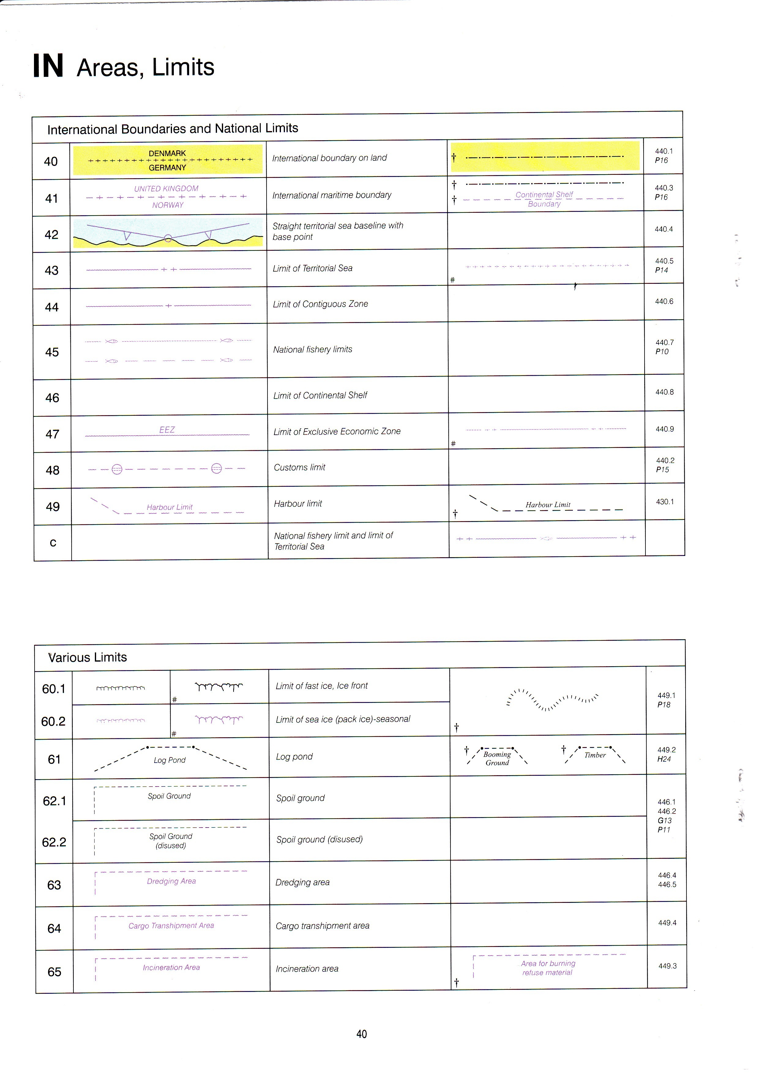
International Boundaries and National Limits | ||||
|
40 |
DENMARK GERMANY |
International boundary on land |
t ------------------------- |
440.1 P16 |
|
41 |
UNITED KINGDGM NORWAY |
International maritime boundary |
t............. . ______Cpnpnwtel Shelf____________ ' Boundary |
440.3 P16 |
|
42 |
Straight territorial sea baseline with base point |
440.4 | ||
|
43 |
Limit of Territorial Sea |
440.5 P14 | ||
|
# | ||||
|
44 |
-----H----- |
Limit of Contiguous Zonę |
ł |
440.6 |
|
45 |
--X3*----- >0 - |
National fishery limits |
440.7 P10 | |
|
46 |
Limit of Continental Shelf |
440.8 | ||
|
47 |
EEZ |
Limit of Exclusive Economic Zonę |
# |
440.9 |
|
48 |
- -O-------0-- |
Customs limit |
440.2 P15 | |
|
49 |
x ^ Harbour Limit |
Harbour limit |
\ ^ Harbour Limit t |
430.1 |
|
c |
National fishery limit and limit of Territorial Sea |
+■ --—-- --+ + | ||
|
Various Limits | |||||
|
60.1 60.2 |
rrr>rrn-rrrrr^ |
Yrrrr^ # |
Limit of fast ice, Ice front |
y'i t |
449.1 P18 |
|
YryNpT*' # |
Limit ofsea ice (pack ice)-seasonal | ||||
|
61 |
Log Pond s-'*s |
Log pond |
^ / Booming / Timber N\ / Ground \ ' \ |
449.2 H24 | |
|
62.1 62.2 |
Spoił Ground i i |
Spoił ground |
446.1 446.2 G13 P11 | ||
|
Spoił Ground i (disused) i |
Spoił ground (disused) | ||||
|
63 |
Dredging Area I |
Dredging area |
446.4 446.5 | ||
|
64 |
Cargo Transhipment Area i |
Cargo transhipment area |
449.4 | ||
|
65 |
i Incineration Area I |
Incineration area |
Area for burning j refuse materiał |
449.3 | |
40
Wyszukiwarka
Podobne podstrony:
IN 1 IN Areas, Limits General Dredged and Swept Areas —>11 Submarine Cables, Su
19862 IN 2 Areas, Limits IN Restricted Areas 20 r~ T- ~r T W T ~r *r -} rvTi j-, * h j. jlr -i fS
IL 1 Chart 5011 5Offshore Installations IL Areas, Limits —■> IN Oilfields and
DSC07875 (3) Fig. 1. Distribution of inland dunes in Poland 1 - dunes and sand areas (Galon 1958), 2
Indie makieta świątyni wiifcii Ul %atjgc numoers to islam and to ionn the majonty of Ute popuiation
MA in International Business and NegotiationsCollegium Civitas address: Pałace of Culture and Scienc
151 -. 2015. The Iron Cage of Liberalism: International Politics and Unarmed Revolutions in the Midd
176 Perl, Raphael. The FalklandIslands Dispute in International Law and Politics: A Documentary Sour
tabela slajd7 internet Users and Penetration In Select Countries Worłdwide, 2006 (millions and % of
Mednarodna fakulteta za drużbene in poslovne Studije International School m for Social and Business
In areas with high deer density and limited food plot acreage, warm-season legumes like lablab may n
Challenges for International Business and Teaching in the CEE Region - Towards an lntegrative
Online International ConferenceBEINGONE AND MANY FACES OF THE HUMAŃ IN THE 21st CENTURY
2nd INTERN SEMINAR AND MNS «. ŚLIWICE, SEPTEMBĘR i tf i HTTP Włi1 .PI i IM in a p/iiiH L
więcej podobnych podstron