558
■ Chapter 14
■
Volume 5
Type of Chart
Scale
HARBOR CHARTS
(outlined in red)
1:50,000 and larger
COAST CHARTS
(outlined in purple)
1:50,001 to 1:150,000
GENERAL CHARTS
(outlined in purple)
1:150,001 to 1:600,000
SAILING CHARTS
(outlined in purple)
1:600,001 and smaller
SMALL-CRAFT CHARTS
(outlined in green)
1:800,000 and larger
25641
25641
25645
25647
25649
25644
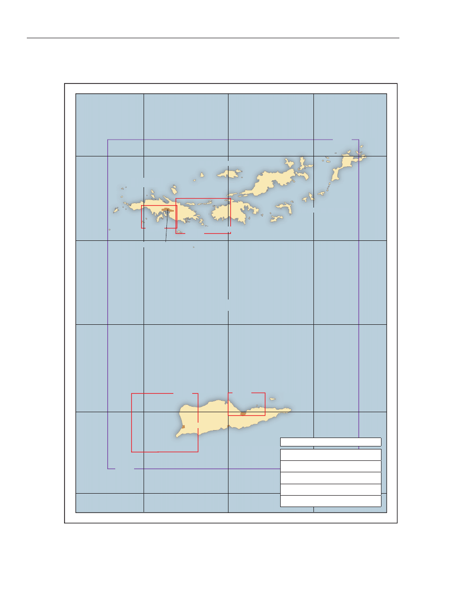
Pillsbury Sound
Frederiksted
Christiansted
Peter Island
Tobago Island
Jost Van Dyke Island
Norman Island
Charlotte Amalie
Port Alucroix
Sir Francis Drake Channel
18°
30'
18°
30'
18°
15'
18°
15'
17°
45'
17°
45'
17°
30'
17°
30'
64°
45'
64°
45'
65°
65°
64°
30'
64°
30'
18°
18°
Mar Caribe
St. Croix
St. Thomas
St. John
Tortola

Virgin Islands
(1)
This chapter describes the United States Virgin Is-
lands, which include the islands of St. Thomas, St.
John, and St. Croix, and about 40 small islets or cays.
Information is given on the ports and harbors of the
islands including Charlotte Amalie, Christiansted, Krause
Lagoon, Cruz Bay, and Frederiksted. A general descrip-
tion of the British Virgin Islands is also included; more
complete information is given in Pub. No. 147, Sailing
Directions (Enroute), Caribbean Sea, Vol. I, published
by the United States National Geospatial-Intelligence
Agency, and West Indies Pilot, Volume II, published by
the United Kingdom Ministry of Defense Hydrographic
Department.
Note
(2)
In this chapter a chart number marked by an aster-
isk indicates that the chart is published by National
Geospatial-Intelligence Agency.
(3)
The United States Virgin Islands, separated from
the easternmost island of the Puerto Rico group by
8-mile-wide Virgin Passage, were purchased from Den-
mark in 1917, and United States citizenship conferred
upon the islanders in 1927. Under the revised Organic
Act of 1954, legislative powers are vested in a Senate,
whose members are elected by the islanders for 2-year
terms. The Governor, who has certain veto powers, is
elected by the people of the U.S. Virgin Islands. The
capital is Charlotte Amalie, on the island of St. Thomas.
(4)
The British Virgin Islands are N and E of the
United States group. The United States-United King-
dom boundary extends SE between Hans Lollik and Lit-
tle Tobago Islands, thence through the narrows
between St. John and Tortola Islands, and thence S
through Flanagan Passage between Flanagan and Nor-
man Islands.
Prominent features
(5)
Making the Virgin Islands from the N, Virgin Gorda
(British) will be seen on the extreme left, rising in a
clear, well-defined peak about 1,400 feet high. Next to
Virgin Gorda, Tortola (also British) will appear most
conspicuous; the highest mountain appears flattened
and elongated from N but rises to an elevation of about
1,800 feet. Immediately W of Tortola will be seen the
rugged, pointed peaks of Jost Van Dyke (British), rising
to about 1,100 feet, and behind them the irregular
small peaks rising from the tableland of St. John (U.S.)
to heights of 800 to 1,300 feet.
(6)
From about 20 miles N of the islands, a separation
will be observed between St. Thomas and St. John, but
St. John, Jost Van Dyke, Tortola, and Virgin Gorda will
appear to be one large island. St. Thomas is less rugged
in outline than the other islands, but it may be recog-
nized from its large midisland saddle which has horns
nearly 1,600 feet high; the saddle is equally conspicu-
ous from the S.
COLREGS Demarcation Lines
(7)
The lines established for the Virgin Islands are de-
scribed in 80.738, chapter 2.
Vessel Traffic Management
(8)
(See Part 161, Subpart A, chapter 2, for regula-
tions requiring notifications of arrivals, departures,
hazardous conditions, and certain dangerous cargoes
to the Captain of the Port.)
Routes
(9)
From Charlotte Amalie to the Straits of Florida,
proceed through Virgin Passage and thence as direct as
safe navigation permits along the N coasts of Puerto
Rico and Hispaniola, and then along the N coast of
Cuba through Old Bahama and Nicholas Channels to
destination. The distance is 1,086 miles.
(10)
Bound to Baltimore, New York, or Boston, pass W
of Sail Rock and, when clear of Virgin Passage, take a
great circle course direct to destination. Distances
from Charlotte Amalie are 1,418 miles to Baltimore,
1,435 miles to New York, and 1,517 miles to Boston.
Currents
(11)
The currents among the Virgin Islands, although of
considerable importance to navigators, are not well es-
tablished by observation. The tidal current is said to set
SE and NW. In the general vicinity of the islands there
is an oceanic current with a velocity of about 0.2 knot
that sets in a direction varying from NW to W.
Weather
(12)
The following description of weather conditions in
the Virgin Islands was prepared by the Office of
Virgin Islands
■
Chapter 14
■
559

Climatology, Environmental Data and Information
Service. (See Appendix B for St. Croix climatological
table.)
Wind
(13)
One of the outstanding features of the climate in
the Virgin Islands is the steadiness of the trade winds.
They blow almost without exception from an E direc-
tion, or between NNE and SSE. The highest mean max-
imum wind speeds usually occur in July. Superimposed
on the trade winds are the land and sea breezes, which
are important in most coastal areas. Night winds are
lighter than the daytime winds. About daybreak the
wind speed begins to pick up, reaching a maximum late
in the morning or early afternoon. A return to the
lighter nighttime winds begins during the late after-
noon, usually about 1600. It must be remembered that
these islands are located in the path of occasional tropi-
cal storms or hurricanes and extremely high winds
may be experienced during such passages. Thirteen
tropical systems have passed within 50 miles of Char-
lotte Amalie since 1950 including Georges in 1998,
Marilyn in 1995, Hugo in 1989, and Donna in 1960.
Both Hugo and Donna provided winds in excess of 130
knots. (See chapter 3 for information about hurri-
canes.)
Precipitation
(14)
The time of maximum rainfall expectancy is
roughly from May through November or December,
with showers providing most of the rain. The heavier
rains have usually been associated with tropical cy-
clones and hurricanes that are most likely to reach the
area during the months of August, September, and Oc-
tober; or with frontal systems or E waves which may
reach the area in these or other months. The average
annual rainfall at Charlotte Amalie is 41 inches with a
maximum rainfall during September and a minimum
in February. The average annual temperature at Char-
lotte Amalie is 80.4°F with a average maximum of
85.7°F and an average minimum of 74.7°F. Each
month, April through November, has recorded maxi-
mum temperatures in excess of 90°F with the all-time
maximum, 92°F, occurring in six separate months:
May, and July through November, of various years. The
extreme minimum temperature recorded at Charlotte
Amalie is 63°F recorded in January 1956.
Pilotage, U.S. Virgin Islands
(15)
Vessels of and above 100 gross registered tons and
those vessels carrying explosives and dangerous cargo
must engage for the services of an Insular Government
pilot in order to enter, leave, or shift berths in a U.S.
Virgin Islands port. Vessels of less tonnage, and vessels
of the United States or foreign governments and
pleasure craft are exempt from pilotage unless a pilot is
actually employed. Exempted vessels when requiring
the services of a pilot will be charged the regular rate.
Pilots will take all classes of vessels in or out, day or
night, unless otherwise noted. Arrangements for pilots
are generally made 24 hours prior to the ship’s arrival
by the ship’s agents.
Quarantine, customs, immigration, and agricultural
quarantine
(16)
National quarantine laws are enforced in the U.S.
Virgin Islands by officers of the U.S. Public Health Ser-
vice. All vessels from foreign ports, vessels with sick-
ness on board, and vessels from domestic ports where
certain quarantinable diseases prevail are subject to in-
spection. (See Public Health Service, chapter 1.)
(17)
The customs collection district of the U.S. Virgin
Islands is under the jurisdiction of the U.S. Treasury
Department but has its own customs laws. Imports
manufactured in the United States enter free of duty.
All foreign goods coming into the islands are subject to
an import duty of 6 percent, ad valorem, unless speci-
fied as free of duty, even if imported from continental
United States.
(18)
Agricultural quarantine laws are enforced by offi-
cials at Charlotte Amalie and Christiansted.
(19)
The United States immigration laws apply in the
U.S. Virgin Islands. Passports and visas are required by
persons other than U.S. citizens.
Wharves
(20)
Deep-draft facilities are at Charlotte Amalie, St.
Thomas Island, and on St. Croix Island at Frederiksted,
and at the private facilities at Krause Lagoon and in
Limetree Bay. Vessels drawing up to 16 feet can go
alongside Gallows Bay Dock at Christiansted, St. Croix
Island. At other places only small craft go alongside the
wharves.
Supplies
(21)
Bunker fuels, diesel oil, and gasoline are available
only at Krause Lagoon on an emergency basis. Diesel
fuel, water, and marine supplies are available at Char-
lotte Amalie. Limited marine supplies can be obtained
at Christiansted and Frederiksted. Gasoline, diesel fuel,
and marine supplies for small craft are available at the
marinas around the islands.
Repairs
(22)
There are no facilities at any of the ports for major
repairs to deep-draft vessels. Machine shops at Char-
lotte Amalie, Christiansted, and Frederiksted can make
minor above-the-waterline repairs.
560
■ Chapter 14
■
Volume 5

Communications
(23)
The islands of St. Thomas, St. John, and St. Croix
have good highways. Regular air service is maintained
between St. Thomas Island, St. Croix Island, San Juan,
United States, and some foreign ports. Cruise ship lines
call at Charlotte Amalie and Frederiksted. Small
interisland vessels operate from United States Virgin
Island ports to the British Virgin Islands, Puerto Rico,
and other West Indies ports.
(24)
Telephone, radio, and cable service facilities are
available on the islands of St. Thomas, St. John, and St.
Croix.
Currency
(25)
The monetary unit is the U.S. dollar.
Standard time
(26)
The U.S. Virgin Islands use Atlantic standard time,
which is 4 hours slow of Greenwich mean time. The
U.S. Virgin Islands do not observe daylight saving time.
Chart 25640
(27)
Most of the Virgin Islands are situated on the S side
of Virgin Bank which extends in an E and ENE direc-
tion for 86 miles from the E end of Puerto Rico. For
about 50 miles the bank trends E, averaging 25 miles in
width, and then swings slightly ENE, increasing in
width to 32 miles. It terminates close beyond the SE ex-
tremity of Anegada Island in a point several miles wide.
(28)
The bank is an ocean shelf, with abrupt drops in
depths near its edges. On the N side of the island group,
W of 64°40'W. and within half a mile of the islands, the
general depths range from 18 to 40 fathoms except for
the outlying banks. E of this line, the depths gradually
decrease until soundings of 6 fathoms are found about
0.8 mile off the W end of Anegada Island. On the S side
of the island group, the depths differ considerably from
those on the N side. The S side is bold and wall sided,
and lies from 1 to 7 miles off the islands; general depths
of 8 to 33 fathoms are found in this area. Close within
the outer edge of the bank is a narrow ledge of coral
that extends almost unbroken from Horse Shoe Reef, at
Anegada Island, to Isla de Vieques. This ledge, about
200 yards wide, has depths of 11 to 19 fathoms.
(29)
Whale Banks, about 13 miles N of Tortola Island
and 15 miles W of Anegada Island, are two patches with
depths of 12 to 20 fathoms on the N bank and a least
depth of 10 fathoms on the S bank. Turtle Head, a coral
reef covered 6 fathoms, is about 10 miles N of Jost Van
Dyke Island and 13 miles NW of Tortola Island. Barra-
couta Banks about 8 miles NW of Jost Van Dyke, con-
sist of several patches covered by 11 to 20 fathoms.
Kingfish Banks, about 5 miles NNE of Jost Van Dyke Is-
land, are two coral patches with 8 fathoms over them.
Chart 25650
(30)
Virgin Passage is 8 miles wide between Savana Is-
land and Isla Culebrita, with depths of from 11 to 17
fathoms in the S part and up to 27 fathoms in the N
part. It is clear except for Bajos Grampus on the SW
side and Sail Rock on the SE side.
Tidal currents
(31)
In the middle of the passage the current velocity is
about 0.5 knot and sets S and N. On the E side of the
passage near Savana Island the velocity increases to
about 2 knots.
Charts 25641, 25650
(32)
Sail Rock, on the E side of Virgin Passage about 7.6
miles ESE of Isla Culebrita, is so called from its resem-
blance to a vessel under sail. It rises precipitously from
the sea to a height of 125 feet. It is about 100 yards in
diameter, quite barren, and light gray in color. It is
steep-to on all sides, but a rock awash is about 200
yards W of the islet. A lighted buoy is about 0.5 mile W
of the islet.
(33)
St. Thomas Island, commercially the most impor-
tant of the U.S. Virgin Islands, is 34 miles E of Puerto
Rico. It is 12 miles long and from 1 to 3 miles wide. A
lofty ridge extends along its whole length. Signal Hill,
nearly in the center of the island, is 1,504 feet high, and
Crown Mountain, 1.7 miles to the W, is 1,550 feet high.
Lights are shown from towers on the summit of each.
(34)
The W half of St. Thomas presents the appearance
of a steep ridge sloping precipitously to the N and the S,
with numerous ravines widening at their lower ends
into small tracts of level land on the seacoast. Between
these level tracts the coast is usually bold with rocky
promontories of considerable height. The higher hills
are flat-topped and plateaulike, whereas the lower ones
are for the most part dome shaped. The country is al-
most entirely wooded; the region W of Perseverance
Bay is under considerable development.
(35)
The E end of St. Thomas has the appearance of two
main ridges, separated by a large basin and sloping to
the N and S with numerous smaller ridges and spurs
making off from them. St. Thomas is almost sur-
rounded by small islands and cays, in general, bold and
steep-to, with very few hidden dangers to guard
against.
(36)
Savana Island, 2 miles WSW from the W end of St.
Thomas, is nearly a mile long and 0.5 mile wide. Savana
Virgin Islands
■
Chapter 14
■
561

Island Light (18°20'24"N., 65°05'00"W.), 300 feet above
the water, is shown from a white tower at the SW end of
the island. The island is covered with a dense growth of
vines, small trees, and underbrush. The entire NW
shore is bold and precipitous with rock cliffs rising
abruptly from the water’s edge to as much as 120 feet.
Din Point is a bold dark headland, with cliffs 80 to 100
feet high, at the NW extremity of the island. The SE
shore of the island is generally rocky with short
stretches of gravel beach in the bights. Depths of 34 feet
and less extend up to 0.5 mile from the E side of the is-
land. Just N of Virgin Point, the SW extremity of the is-
land, the cliffs are of crushed rock and sandstone
formation and from offshore appear as red cliffs. De-
tached rocks extend 200 yards S of Virgin Point.
Domkirk Rock, a crag with twin steeple-shaped pinna-
cles which resemble a cathedral, is 100 yards SE of Vir-
gin Point. Some rocks 8 to 10 feet high and steep-to are
on a sunken ledge which extends about 700 yards off
the NE point.
(37)
The currents in the vicinity of the NE point of
Savana Island are very strong, and small boats should
give the reef a wide berth. Boat landings may be made
in smooth weather.
(38)
Kalkun Cay, in the middle of Savana Passage, is a
narrow islet, 275 yards long and about 20 to 30 yards
wide, which is covered with grass and small under-
brush. About 0.5 mile SE of the cay is Saltwater Money
Rock, 8 feet high, steep-to, with a clear channel be-
tween.
(39)
Little St. Thomas is a low grass-covered peninsula
connected with the W end of the island of St. Thomas
by a sandspit. A 50-foot hill is near the NE point and a
21-foot bluff is at the S end. Mermaids Chair, 15 feet
high, is a conspicuous rock that has the shape of a chair
at the apex of a triangular coral reef projecting from the
SW point of Little St. Thomas. Small boats stay in the
small gravel cove S of the peninsula when the sea is too
rough to land at Sandy Bay or Botany Bay. A boat pas-
sage is between Little St. Thomas and a 42-foot islet
100 yards to the N.
(40)
Big Current Hole is a passage separating West Cay
from Little St. Thomas. There are rocks awash extending
E from West Cay; the outer one, Drum Rock, 2 feet
high, constricts the channel, the strong currents and
heavy tide rips render the passage difficult. Small boats
using this passage, when passing through from S, head
for Drum Rock and leave it close-to on the port hand.
(41)
West Cay, 0.2 mile NW of Little St. Thomas, con-
sists of 2 hills, 121 and 114 feet high, connected by a
neck of low land. The small stretch on the E side of the
cay is gravel. Landing may be made in the bight on the
S side.
(42)
Salt Cay, 242 feet high and 0.6 mile NW of Little St.
Thomas, is generally rocky and rugged, particularly on
the N coast where cliffs rise precipitously to 100 and
150 feet high. Many rocks awash are close-to on the SW,
W, and E sides of the cay. The channel between Salt Cay
and West Cay is shallow, and breakers extend across it.
(43)
Salt Cay Passage is about a mile wide, with deep
water in the channel, and is free of dangers.
(44)
Dutchcap Cay, a mile NW of Salt Cay, rises abruptly
from the sea to 278 feet high, with cliffs 100 feet high
on the N shore.
(45)
Cockroach Island, 3.3 miles NNW from the west
end of St. Thomas Island, is 151 feet high and of irregu-
lar shape. The south shore is bold and precipitous with
white rocky cliffs rising abruptly from the water’s edge
to a height of 120 feet. The N shore is rocky with cliffs
back from the shore rising to a height of 80 feet, and in-
dented by numerous small bights and crevices. Cricket
Rock, 0.5 mile ENE from Cockroach Island, is 46 feet
high, bold, and steep-to, with sharp pinnacle rocks on
top.
(46)
Dutchcap Passage, just S of these islands, is free of
dangers.
Currents
(47)
In navigating the passages between this group of is-
lands, it is necessary to guard against the tidal cur-
rents, which in Savana Passage run with a velocity of 3
knots and in the others about 1 knot. Sailing vessels
beating up against the northgoing current should
stand well to S of Savana Island, so as to avoid the
strength of the inshore current.
(48)
The N coast of St. Thomas Island is very irregular
with rocky cliffs and sandy beaches in the shallow bays.
Much of the beach is fringed with coral reef making
landing difficult in most places. The bays in the E half
of the island are open to the prevailing E trade winds.
Islands, rocks, and shoals are as much as 3 miles from
the shore.
(49)
Sandy Bay and Botany Bay are shallow bights sepa-
rated by a rocky point at the W end of St. Thomas Is-
land. Small-boat landings can be made during calm
weather.
(50)
Santa Maria Bay, 2.5 miles E of Botany Bay, has
depths of 20 feet or more and is a fair shelter, but it is
seldom used because of rollers.
(51)
Inner Brass Island and Outer Brass Island are off
the N side of St. Thomas about 4 miles from the W end.
A 22-foot channel is between St. Thomas and Inner
Brass Island; Brass Channel, between the two small is-
lands, has a depth of 48 feet.
(52)
Inner Brass Island has a generally rocky shore,
with reefs extending as much as 300 yards off the E
side. There are detached rocks and rocks awash within
562
■ Chapter 14
■
Volume 5

that area. Occasional large swells are prevalent be-
tween the southern tip of the point and the Dorthea
Point. The swells are largest during winter months.
NW of the S tip is a fine sand beach with a fringing coral
reef. The reef has several breaks through which
small-boat landings can be made. A well-sheltered an-
chorage for local boats is off the SW side of the island.
(53)
The E shore of Outer Brass Island is bold and pre-
cipitous with rocky cliffs rising vertically from the wa-
ter. The W shore is rocky and slopes up uniformly. Cave
Cove, in about the middle of the W shore, has a large
cave opening into it. Rough Point, the N extremity of
the island, is sharp and jagged, and, on calm days, land-
ings can be made on its W side. A 15-foot spot is about
330 yards W of Rough Point.
(54)
Landings may be made on St. Thomas Island
through breaks in the fringing coral reef in Caret Bay
and Neltjeberg Bay SW and S of Inner Brass Island.
Hull Bay, SE of Inner Brass Island, is shoal with a reef
and heavy surf along the SW shore. More reefs lay along
the western shoreline, though a small craft channel
runs in the middle of the bay. Numerous fishing and
recreational boats are moored in Hull Bay; a ramp is
available.
(55)
Lizard Rocks, 0.7 mile offshore and 0.8 mile W of
Inner Brass Island, are a group of bare rocks and rocks
awash. Ornen Rock, with 6 feet over it, is a mile E of In-
ner Brass Island. Waves do not ordinarily break over
Ornen Rock but may during a heavy ground swell.
(56)
Magens Bay is a prominent bight on the N shore of
St. Thomas. It is 1.6 miles long and 0.6 mile wide. Its E
side is formed by a long, narrow tongue of land called
Peterborg, which terminates to the NW at Picara Point,
nearly midway between Hans Lollik and the Brass Is-
lands, and its W side by St. Thomas Island and Tropaco
Point. Prominent is a 50-foot cliff at the end of Tropaco
Point. The bay, safe only for small vessels, is open to the
NW and consequently exposed to rollers. Peterborg and
the west side of St. Thomas are being extensively devel-
oped. Entering from the N or NW, avoid Ornen Rock
and from the E, during calm seas, the rocks 30 yards
NE of Picara Point. During heavy ground swells, a con-
fused sea exists in the area of these rocks, and the point
should be given a wide berth.
(57)
The depth in Magens Bay varies from 5 to 12 fath-
oms, but the S portion has a bank of 1¼ fathoms, ex-
tending 0.3 mile from the shore, surrounded by depths
of 2 to 3 fathoms. A fine sand beach is at the head of the
bay. Reseau Bay and Lerkenlund Bay, small bights on
the W shore of Magens Bay, are used by fishermen to
beach their boats.
(58)
Hans Lollik Island, 713 feet high, 1.3 miles long,
and about 0.8 mile wide, is 1.8 miles NE of Picara Point.
The W side of the island is precipitous and rocky, except
in a bay on the W side which has a gravel beach. Coco-
nut Bay, on the SE face, is protected by off-lying White
Horseface Reef. This bay is a protected anchorage for
small boats and may be entered through a channel SW
of the reef. Hansa Rock, close inshore at the S point, is
19 feet high and S of a small bay that is accessible to
small boats in calm seas. Hans Lollik Rock, awash and
on which the sea always breaks, is over 0.3 mile ESE of
the S point of Hans Lollik Island.
(59)
Little Hans Lollik Island is 0.2 mile N of Hans
Lollik Island and connected with it by a coral ledge over
which the sea breaks. There is an opening in the reef;
extreme caution should be used when navigating
through the reef. The shoreline consists mostly of
rocky cliffs from 20 to 60 feet high. Steep Rock, the
only detached rock on the E shore of the island, is 25
feet high.
(60)
Pelican Cay, 200 yards N of Little Hans Lollik Is-
land, is a 20-foot grassy islet accessible in calm seas.
Between the two are several rocks awash, and a reef
over which the sea breaks is close NE of Little Hans
Lollik Island. Except for these dangers, the channels on
either side of the Hans Lollik group are clear.
Chart 25647
(61)
Mandal Bay, 3 miles E of Picara Point, is shoal, with
a sandy beach at its head. Mandal Point, just E of the
bay, is 277 feet high, with cliffs 100 to 120 feet high at
the water’s edge. An unmarked channel, W of the point,
has a rock jetty on either side which leads through the
reefs and a landcut to a small dredged harbor. The
channel has shifting sand bars and can be shallow. On
the E side of the bay, a rubble mound breakwater ex-
tends 270 feet from shore on the N side of the channel
entrance, and a smaller rubble mound jetty extends 70
feet from shore on the S side. A depth of about 10 feet
was reported in the channel in 1972. To the SE of
Mandal Bay is Tutu Bay with fringing reef on the E side.
The bay often experiences heavy waves.
(62)
Water generally breaks on a reef close NE of Mandal
Point. A 23-foot spot is 0.3 mile E of the point.
(63)
Coki Point, 1.9 miles ESE of Mandal Point, has a
47-foot high bluff with a sandy beach on the N side and
shoreline foul with coral and fringing reef E and W of
the beach. It forms the N shore of Water Bay. A conspic-
uous 235-foot cone-shaped hill is just S of Water Bay.
Turtleback Rock, 2 feet high, is off the entrance to Wa-
ter Bay 0.3 mile SE of Coki Point. Midway between Wa-
ter Bay and Cabes Point is a small sandy beach located
at Footer Point. There are several boulders off Footer
Point placed as a breakwater which are covered by wa-
ter. Cabes Point is a low rocky hook 1 mile SE of Coki
Virgin Islands
■
Chapter 14
■
563

Point. Shark Island, 32 feet high, is about 0.3 mile ESE
of Cabes Point. Foul ground encircles the island with
several visible rocks 125 yards off the NE end.
(64)
Just to the W of the Cabes Point is a small cove lo-
cally referred to as Lindquist Bay. Shallow reef are
prominent on the W and E sides with a sand beach in
the center, commonly referred to as Lindquist Beach.
An unmarked channel lies in the middle of the cove.
(65)
St. John Bay, on the SE side of Cabes Point, has a
shallow fringe reef at the W and E ends. A channel lies
near the center of the bay and small boats can land
ashore. A strong current runs between Shark Island
and Prettyklip Point, locally referred to as Sapphire
Beach.
(66)
Just SE of Prettyklip Point is a spit of land with ho-
tels and condominiums. A marina is located in the al-
cove W of the spit. Buoys reported mark the channel to
the marina.
(67)
Redhook Bay, at the E end of St. Thomas Island,
consists of a S arm called Muller Bay and the W arm,
Vessup Bay Ferry boats to St. John Island use a small
L-shaped pier in the NE part of Vessup Bay. In 1972, a
depth of 9 feet was reported at its face. The channel
through Redhook Bay into Vessup Bay is marked by pri-
vate buoys. A marina is 200 yards W of the L-shaped
pier. Berths, gasoline, electricity, water, ice, and marine
supplies are available. Repairs can be made to gasoline
or diesel engines and to some electronic equipment.
The National Park Service maintains an L-shaped pier
on the S side of Vessup Bay; in 1972, depths of about 6
feet were reported alongside.
(68)
Cabrita Point, the E end of St. Thomas, rises to a
height of 210 feet. A neck of land joins the remainder of
St. Thomas. A 24-foot spot lies 0.6 mile ESE of Cabrita
Point.
(69)
Pillsbury Sound is the body of water between St.
Thomas, St. John, and the cays which bound the sound
on the N side, forming an excellent roadstead about 2
miles in extent E and W and 1.5 miles N and S. This area
is quite secure against rollers and all winds except from
the S which blow only in the hurricane months, but the
area can become quite rough. The current attains a ve-
locity of 2 knots.
(70)
The depths in the sound are somewhat irregular,
varying from 41 to 111 feet. All the main passages lead-
ing to it are deeper than the mean depth of the sound it-
self.
(71)
Thatch Cay, at the NW end of Pillsbury Sound, is
1.6 miles long. The island is in the form of a ridge, 482
feet high near the E end.
(72)
Bull Point and Mother East Point are prominent
projecting points on the N side. Lee Point is the W
point and Grouper Point the E point of the island.
There are mooring buoys reported between Lee Point
and Mother East Point on the NW side of Thatch Cay.
Grass Cay, 0.5 mile E of Thatch Cay, is 0.8 mile long.
The N shore consists of rocky cliffs in places 150 feet
high. A narrow rocky ledge, covered 12 feet at its E end,
is close to shore near the W end, and a rock awash is
150 yards W of the same point. There are mooring
buoys reported on the S side of Grass Cay for day use.
(73)
Mingo Cay, E of Grass Cay, is 186 feet high. Be-
tween Mingo and Grass Cays is a narrow shoal passage
with a bare rock 15 feet high close to the middle. It is
only passable by dinghy on very calm days. Several bare
rocks are E of this rock. Lovango Cay is E of Mingo Cay
and separated from it by a shoal passage 300 yards wide;
the tidal current is strong in the 13-foot boat channel.
Several houses and two private piers are in the bight
along the S shore between Murder Rock and the SW
point. Blunder Rocks, 250 yards E of Lovango Cay, are
4 feet high. Congo Cay, a narrow pointed cay N of
Lovango Cay, is separated from it by a channel with
depths of 13 feet. Carval Rock is 0.3 mile E of Congo
Cay. There are several smaller rocks between it and the
cay. There are mooring buoys reported for day use be-
tween Congo Cay and Lovango Cay and on the S end of
Carvel Rock.
(74)
Two Brothers are two small 12-foot-high barren
rocks lying in the middle of Pillsbury Sound; a light 23
feet above the water is shown from the larger rock. A
ledge extends off their NE side, deepening to 30 feet at a
distance of 250 yards. Vessels can anchor in depths of
40 to 65 feet about 0.5 mile NE of Two Brothers on sand
and mud bottom.
(75)
Windward Passage extends between Lovango and
Durloe Cays; it is 0.3 mile wide. Durloe Cays, within
the entrance, cannot be mistaken. On the W side of the
channel are Carval Rock and Blunder Rocks. Vessels of
deep draft may take the passage between Lovango and
Durloe Cays. If the wind dies, sailing craft may anchor
at any time; the bottom is coral and broken shell in less
than 60 feet. With the NE current running against the
wind, this channel has a race that looks like broken wa-
ter. Through Durloe Cays and between them and
Hawksnest Point on St. John Island are deep and clear
passages, but these are not recommended.
(76)
Middle Passage, between Grass and Thatch Cays, is
about 0.3 mile wide and presents no difficulties to pow-
ered vessels, the only dangers being a small rock awash
nearly 150 yards W from the W end of Grass Cay, which
is easily seen. Sailing vessels generally use this passage
in leaving the sound. It may be entered from the N even
on the ebb, provided the trades have not too much of a
S slant.
(77)
Leeward Passage, between Thatch Cay and the N
side of St. Thomas, is about 0.4 mile wide, with general
depths of 60 feet or more. A privately marked fish
564
■ Chapter 14
■
Volume 5

haven, covered at least 60 feet and centered in
18°21'12"N., 64°51'21.5"W., is near the E end of Lee-
ward Passage.
Currents
(78)
Tidal currents with velocities up to 4 knots in Mid-
dle Passage and Windward Passage, and weaker cur-
rents in Leeward Passage, have been reported.
(79)
Three islands and several rocks extend SE for 2
miles from the E end of St. Thomas. The islands are
rugged, with cliffs fronting much of the shores. Dog
Rocks, 9 feet high, are the most E danger of the group
close off the E point of Dog Island. Current velocities
up to 4 knots have been reported in the vicinity of Dog
Island. Other rocks are as much as 0.35 mile from the
shores of the islands.
(80)
Dog Island Cut, between Dog Island and Little St.
James Island, has depths of 17 to 55 feet. Two sub-
merged rocks are in midchannel at the N entrance to
the cut in about 18°18'08"N., 64°49'11"W. The cut
should be used only by small boats with local knowl-
edge. St. James Cut, between Little St. James Island
and Great St. James Island, has depths of 15 to 22 feet,
but caution is necessary to avoid Welk Rocks in the E
approach and The Stragglers, on the W side. A rock
awash is about 125 yards NW of the NE point of Little
St. James Island. A reef extends from this point almost
to the rock.
(81)
St. James Bay, between Great St. James Island and
the E end of St. Thomas Island, provides secure an-
chorage in depths of 23 to 50 feet, except in hurricanes.
Small craft can anchor securely in Christmas Cove ei-
ther N or S of the small cay 300 yards offshore. Cow
Rock, 7 feet high, is the W of a group of rocks in the S
approach to the bay. Calf Rock, 5 feet high, is the E rock
of the group.
(82)
Current Hole, at the N end of St. James Bay, pro-
vides a passage from the S coast of St. Thomas Island to
Pillsbury Sound. Current Rock, 13 feet high and
marked by a light, is in about the center of the passage.
A depth of 24 feet can be carried through the
100-yard-wide channel E of the rock. The current ve-
locity reaches a maximum of 3 knots through Current
Hole and sets N and S. To stem the current, sailing ves-
sels using the passage should await a N current and a
steady breeze.
(83)
Cowpet Bay, in the N part of St. James Bay, is 0.3
mile wide between Water Point and Deck Point. The
bay has depths of 8 to 21 feet. The St. Thomas Yacht
Club has a pier and other private facilities at the head of
the bay.
(84)
Jersey Bay, W of Cowpet Bay, is 1.4 miles wide be-
tween Deck Point and the cays E of Long Point. The bay
has several cays and dangerous rocks scattered
throughout the W part. A 7-foot spot is about 0.25 mile
E of the E point of Cas Cay. Benner Bay, locally known
as The Lagoon, is a smaller bay in the N part of Jersey
Bay. It is one of the most protected small-boat harbors
on St. Thomas Island. Several yacht clubs and marinas
along the N shore of the bay have complete facilities for
small craft. Berths, gasoline, diesel fuel, water, and
some marine supplies are available. A 50-ton mobile
hoist can handle craft up to 65 feet for hull, engine, and
electronic repairs. To reach the facilities, pass E of the
buoy off Red Point, the E point of Cas Cay, and follow
the best charted water toward the whitewashed area on
Rotto Cay. Pass Rotto Cay keeping it 100 yards on your
starboard and proceed past Grassy Cay keeping it close
by on the starboard. Proceed past Grassy Cay to within
100 yards of Bovoni Cay then head in a N direction to
the facilities. The channel leading into Benner Bay is
privately maintained and marked. In January 1981, se-
vere shoaling was reported in the channel; the extent of
shoaling is unknown. Mariners should seek local
knowledge. Also, it was reported that submerged pil-
ings may exist in the area. The waters between Cas Cay
and Patricia Cay are shoal with prominent breakers and
entry in this area could be hazardous.
(85)
The S coast of St. Thomas is very irregular with
projecting rocky cliffs between coves and bays that are
obstructed by rocks and shoals. Dangerous rocks ex-
tend up to a mile from shore.
(86)
Long Point, the SE extremity of St. Thomas Island,
is the terminus of a high prominent ridge with rocky
cliffs 50 feet high.
(87)
Bolongo Bay, about 1.2 miles NW of Long Point,
has a barrier reef that often breaks. A small channel is
navigable to small craft on the NE side.
(88)
Packet Rock, a coral shoal about 100 yards in ex-
tent with a depth of about 5 feet, lies 0.7 mile WSW of
Long Point. The sea breaks over the rock only in heavy
weather, and it cannot be seen until close-to. A buoy is
300 yards SSE of the rock.
(89)
Capella Islands, of which the westernmost is Buck
Island, lie 1.7 miles SW of Long Point, and constitute a
prominent landfall for making St. Thomas Harbor. The
two small islands, of irregular outline, are partially cov-
ered with a scrubby growth and separated by a narrow
channel almost closed by numerous uncovering rocks.
A light, 125 feet above the water, is shown from a white
tower on the highest point of Buck Island, near its E
end. A shallow ledge extends 100 yards off the W end,
and off the N side the depth is 30 feet. A fish haven, cov-
ered 40 feet and marked by private buoys, is on the N
side of a bight at the SW end of Buck Island in about
18°16'42"N., 64°53'55"W. There are numerous moor-
ing buoys in the NW and SW coves of Buck Island.
Virgin Islands
■
Chapter 14
■
565

(90)
Between Capella Island and St. Thomas Island the
currents are weak.
Chart 25641
(91)
Frenchcap Cay is about 3.6 miles SE of Buck Is-
land, and, like Buck Island, is a useful landfall for mak-
ing St. Thomas Harbor. It is 350 yards long and 183 feet
high, and is covered with grass and steep-to. The shore-
line for the most part consists of high rocky cliffs.
Chart 25649
(92)
St. Thomas Harbor, in about the middle of the S
coast of St. Thomas Island, is the only sheltered harbor
in the Virgin Islands that can be entered by large ves-
sels. Although the oval-shaped harbor is small and
open to the S, it is well protected by the high hills sur-
rounding the other sides and provides safe anchorage
except during a hurricane.
(93)
Charlotte Amalie, along the N shore of St. Thomas
Harbor, is the most important city and capital of the
U.S. Virgin Islands. Tourism comprises most of the
commerce. Rum and bay rum are manufactured, and
handicraft articles are made from raw materials im-
ported from nearby islands.
(94)
The port facilities are at the West Indian Dock on
the S side of Long Bay, the E part of St. Thomas Harbor,
and at the Ports Authority pier and quay on the N side
of West Gregerie Channel. Havensight Point on the
east side of the harbor has a dock that can berth up to
three cruise ships simultaneously. The principal im-
ports include foodstuffs, textiles, clothing, building
materials, machinery, and petroleum products. Ex-
ports include rum, perfumes, and sundry articles.
Prominent features
(95)
Muhlenfels Point, the E entrance point to St.
Thomas Harbor, is high and steep at the shoreline. A
large hotel on the point is conspicuous.
(96)
Hassel Island, on the W side of the harbor entrance
is indented by shallow coves and has several high
wooded hills. Cowell Point is the S end of a ridge slop-
ing up to Cowell Battery, the highest point on the is-
land.
(97)
Signal Hill, about a mile NW of St. Thomas Harbor,
is the second highest peak on the island with a lighted
tower on top. From it the main ridge extends ESE,
passing less than 0.5 mile N of Charlotte Amalie. The
town is built around the three spurs that extend S from
the ridge. Frenchman Hill is the W spur. Berg Hill, in
the center, has a square white building on its S slope
near the top. On Government Hill, the E spur, stands
Blackbeard Castle, a remarkable 47-foot stone tower.
(98)
To the E of Government Hill, Bluebeard Hill rises
abruptly from the shore at Frederiksberg Point to a
224-foot summit on which Bluebeard Castle, an old
34-foot stone tower, is located.
(99)
Water Island, SW of the entrance to St. Thomas
Harbor, is indented by several small shallow bays, and
the hilly land is covered by small trees and dense un-
derbrush. Flamingo Point, the S end consists of brown
rocky 100-foot cliffs. N of Flamingo Point on the W
shore is Flamingo Bay which leads to Flamingo Pond
and a small boat harbor and marina. A square tower is
on 256-foot Providence Hill, 0.8 mile N of the point.
There is a small pier on Providence Point that is used by
the ferry serving Water Island. Red Point, a mile NW of
Water Island, is a rugged red cliff on the W side of
Lindbergh Bay.
Channels
(100)
The entrance channel, W of Muhlenfels Point and
close E of Scorpion Rock, leads close SW of West Indian
Dock; depths in the channel are about 27 feet. The en-
trance channel is marked by a lighted range and buoys.
In 1976, it was reported that depths of 10 to 14 feet
could be taken to the waterfront at Charlotte Amalie.
(101)
East Gregerie Channel, between Hassel Island and
Water Island, has depths of 26 to 48 feet for the
350-yard center width. Haulover Cut, between Hassel
Island and St. Thomas Island, has a least depth of 12
feet through the center of the narrow passage. At the
SW entrance, a reef that uncovers extends about 80
yards into the cut from Hassel Island. Rocks, sub-
merged and awash, border the N side of the channel.
East Gregerie Channel is marked by lighted buoys.
Caution is advised for all vessels traversing this area
since it is an active seaplane landing area.
(102)
West Gregerie Channel, between Water Island and
St. Thomas Island, has depths of 26 to 60 feet for a
250-yard center width to the junction with East
Gregerie Channel N of Water Island. The channel is
marked by buoys and a light. A lighted radio tower at
the base of Careen Hill has been reported to be an excel-
lent mark to steer for when entering West Gregerie
Channel.
(103)
Ruyter Bay, a shoal bay on the NW side of Water Is-
land, has a privately owned L-shaped pier, about 100
feet long with a 30-foot length at the outer end; in 1972,
depths of about 6 to 10 feet were reported alongside. A
depth of about 8 feet can be carried with local knowl-
edge when approaching the pier from the NW.
566
■ Chapter 14
■
Volume 5

Anchorages
(104)
General, small craft, and arrival inspection anchor-
ages are in St. Thomas Harbor and off Lindbergh Bay.
(See 110.1 and 110.250, chapter 2, for limits and reg-
ulations.)
(105)
Krum Bay, NW of Water Island, has depths of 35
feet in the entrance, shoaling to 11 feet near the head.
An oil company maintains a lighted T-head pier and a
barge dock on the W side of Krum Bay, about 0.1 mile
and 0.4 mile, respectively, N of Mosquito Point, on the
W side of the entrance. The bay affords excellent an-
chorage for small vessels during a hurricane.
(106)
Lindbergh Bay, close W of Krum Bay, is used as an
anchorage by small sloops and motorboats. The en-
trance depths are 30 feet, gradually decreasing to a fine
sand beach and small pier at the head of the bay.
Dangers
(107)
Green Cay, 1 mile SE of Muhlenfels Point, is a small
24-foot islet covered with low underbrush. The islet is
near the center of a coral reef that extends about 450
yards SW from shore. Another islet is 50 yards S of
Green Cay.
(108)
Triangle is a group of dangerous rocks between
Green Cay and Muhlenfels Point. The N and SW parts of
the group are partly awash. Barrel of Beef, 2 feet high,
is the E foul area of the group. A detached coral rock
covered 16 feet and marked by a lighted buoy is nearly
0.7 mile SSE of Muhlenfels Point.
(109)
Point Knoll, a coral head with several submerged
rocks, extends 50 yards SW from Muhlenfels Point; a
depth of 20 feet is about 90 yards SW of the coral head.
Rohde Bank, 0.2 mile NW of Muhlenfels Point, has a
least depth of 17 feet.
(110)
Scorpion Rock, in the entrance between Muhlenfels
Point and Cowell Point, is a small coral rock with a
least depth of 28 feet surrounded by depths of 32 to 38
feet. A lighted buoy marks the rock.
(111)
Rupert Rock, 0.5 mile N of Muhlenfels Point at the
narrowest part of the entrance channel, is 12 feet high
and white on top. A drying reef and foul ground with
less than 6 feet over it extends 100 yards W from the
rock. A lighted buoy and a daybeacon are W of the rock.
(112)
Foul ground with depths less than 6 feet surround
Hassel Island and Water Island up to 300 yards from
shore.
(113)
Porpoise Rocks, a mile W of the S end of Water Is-
land, consists of three reefs with rocks bare or awash
and depths of 2 to 17 feet. A buoy is on the SW side.
(114)
An unmarked fish haven is off the S side of Porpoise
Rocks.
(115)
A rocky ledge extends 0.4 mile S of Red Point. A
steep-to rock at the outer end has a least depth of 3 feet
over it.
(116)
An airport runway extension is on the E side Brew-
ers Bay 0.6 mile NW of Red Point. The runway extends
about 800 yards W from shore and is surrounded by a
rock dike. Caution is advised in the area.
(117)
Sandy Point Rock, an elongated shoal extending
300 yards NW from the N end of Water Island, has a
least depth of 3 feet and is marked by a light at the NW
end.
(118)
Care should be taken when navigating in the main
harbor of Charlotte Amalie, Haulover Cut, and East
Gregerie and West Gregerie Channels, because of their
use as seaplane operating areas. The seaplanes gener-
ally take off on a SE heading from Cay Bay to Rupert
Rock, and occasionally from Crown Bay through the
East Gregerie Channel, also on a SE heading. The sea-
planes generally land on a NE heading between the
light in West Gregerie Channel and Haulover Cut, then
proceed into Cay Bay. The seaplanes, when landing,
usually traverse the narrow Haulover Cut area at a high
rate of speed. Vessels navigating in these waters should
remain alert to the presence of seaplanes when operat-
ing in the areas defined above.
Currents
(119)
The current velocity in East and West Gregerie
Channels is about 0.5 knot, although a greater velocity
has been reported in the western side of Crown Bay.
Caution should be exercised to avoid being set onto the
piers in the bay, particularly with a strong E wind.
Routes
(120)
From W: pass 0.5 mile or more off the S end of Wa-
ter Island, then steer for Muhlenfels Point until on the
entrance range, and then proceed into the harbor on a
heading of 344°. The prominent white catchment area
on the W side of Berg Hill helps in picking up the range
in the daytime. From S: pass a mile or more W of Buck
Island and enter on the range. From E: set a course to
pass about midway between Buck Island and St.
Thomas Island and enter on the range.
Pilotage, St. Thomas
(121)
See Pilotage, U.S. Virgin Islands (indexed as such)
early this chapter. Pilotage is available from the St.
Thomas Pilots, Virgin Island Port Authority. Office ad-
dress is: P.O. Box 2616, Charlotte Amalie, St. Thomas,
U.S.VI 00803; telephone 340-774-2333, 340-744-2250,
340-774-8580 (boathouse), FAX 340-777-9694. Pilots
can also be contracted through the marine operator,
WAH, on VHF-FM channels 16, 28, and 85 (interna-
tional), 0500 to 2400 hours, daily.
(122)
The pilots boathouse (station) is on the waterfront
at St. Thomas Old Marine Terminal.
Virgin Islands
■
Chapter 14
■
567

(123)
St. Thomas Pilots serve the main harbors of Char-
lotte Amalie, St. John, East and West Gregerie Chan-
nels, and Crown Bay.
(124)
Pilots board vessels entering St. Thomas Harbors
from three points at the entrances. Vessels entering via
West Gregerie Channel are boarded about 0.5 mile W of
West Gregerie Channel Lighted Buoy 2, just W of Por-
poise Rocks. For vessels entering through East
Gregerie Channel, the pilot boards no less than 1.0
mile S of East Gregerie Channel Lighted Buoy WRI.
Vessels entering the port through the main harbor en-
trance channel can pick up the pilot from a position in
the channel S of St. Thomas Harbor Entrance Lighted
Buoy 2.
(125)
The pilot boats, HARRY MAGRAS, 45 feet long, and
WINSTON PARRIS, 42 feet long, each have black hulls
with white superstructures. Both boats have the word
PILOT on their superstructures, painted in orange. The
pilot boats display the standard pilot signals; “HOTEL”
flag by day, and a white light over a red light at night
(all-around lights). The pilot boats and pilot station
monitor VHF-FM channels 16 and 14, and work on
channel 16. Vessels to be boarded should contact the pi-
lot boat prior to arrival for vessel speed (approximately
3 to 8 knots) and boarding side, and rig the pilot ladder
about 3 feet above the water.
(126)
An equatorial current is reported to run, starting in
East Gregerie Channel and traveling out West Gregerie
Channel at a velocity of about 1 to 3 knots.
Towage
(127)
Tugs up to 2,000 hp are available for docking ves-
sels. The tugs monitor VHF-FM channel 16.
Quarantine, customs, immigration, and agricultural
quarantine
(128)
(See chapter 3, Vessel Arrival Inspections, and Ap-
pendix A for addresses.)
(129)
Quarantine is enforced in accordance with regula-
tions of the U.S. Public Health Service. (See Public
Health Service, chapter 1.)
(130)
Seamen requiring emergency hospital attention
are taken to the municipal hospital.
(131)
Charlotte Amalie is a customs port of entry. Vessels
are boarded at anchorage or at their berths. The cus-
toms office is in the Post Office Building.
Coast Guard
(132)
The Coast Guard has a Marine Safety Detachment
in Charlotte Amalie (See Appendix A for address.)
Harbor regulations
(133)
Local rules and regulations for the Port of St.
Thomas are enforced by the Port Authority Dockmasters
at Blyden Terminal.
Wharves
(134)
The West Indian Company Dock, along the S side of
Long Bay, is the primary cruise ship terminal at Char-
lotte Amalie. The well-protected 2,750-foot marginal
wharf has depths of 30 feet reported alongside except
for 27 feet alongside the easternmost 300 feet.
(135)
The waterfront of Charlotte Amalie, is a concrete
marginal wharf with depths of 4 to 14 feet alongside. It
is primarily used by small sailing vessels and motor
launches trading with the nearby islands. The dock is
also used for ferry boats, harbor tour boats and a hotel
water taxi.
(136)
Kings Wharf, a 300-foot finger pier extending from
the point E of the waterfront, is used by Coast Guard
vessels. In 1982, depths of 9 feet were reported along
the N side and 13 feet along the S side. A 6-foot depth is
about 200 yards ESE from the outer end of the pier in
18°20'27"N., 64°55'49"W.
(137)
The waterfront of Crown Bay is a curved concrete
marginal wharf operated by the Virgin Islands Port Au-
thority. Depths of 14 to 15 feet are reported alongside.
The wharf is used primarily for receipt of general cargo.
(138)
The Crown Bay Passenger Facility, operated by the
Virgin Islands Port Authority, is in Crown Bay on the N
side of West Gregerie Channel. The pier, which extends
E from shore, has a 730-foot S face and a 930-foot N
face, and depths of 28 to 32 feet alongside. Just N is the
Cargo Port docks, which is 1,680 to 1,754 feet with 17
to 25 feet alongside.
Supplies
(139)
Groceries and some marine supplies are available
at Charlotte Amalie. When available, water can be de-
livered from pipelines at the West Indian Dock, Crown
Bay Passenger Facility or at anchorage from a barge.
Repairs
(140)
A 100-foot-long drydock, just S of the Crown Bay
Passenger Facility, can handle vessels up to 130 feet
long. Machine shops can make minor above-the-water-
line repairs. For larger vessels, the nearest facilities are
at San Juan and the Panama Canal.
Small-craft facilities
(141)
A marina on the E side of Long Bay has finger piers
with 10 to 12 feet alongside. Berths, water, electricity,
and marine supplies are available. A fuel pier with 28
feet alongside has gasoline and diesel fuel.
568
■ Chapter 14
■
Volume 5

(142)
A marina on the W side of Cay Bay, N of Hassel Is-
land, has berthing and mooring facilities in about 15
feet of water. Gasoline, electricity, water, ice, and ma-
rine supplies are available. A marine railway can handle
craft up to 65 feet long for hull and engine repairs. The
approach to the marina is in a seaplane operating area
so be alert for aircraft.
(143)
A marina, on the N side of Crown Bay Passenger Fa-
cility, has finger piers with reported 12 to 15 feet along-
side. Gasoline, electricity, water, ice, and marine
supplies are available.
Chart 25641
(144)
Saba Island, 202 feet high and triangular in shape,
is 2.4 miles W of Flamingo Point. The N part of the is-
land is low, but the S part has precipitous red cliffs 150
feet high along the S shore. Two small lagoons sur-
rounded by mangroves are near the N end. A landing
can be made on the sand beach along the NW shore.
About 150 yards E of the island is a reef with a bare rock
5 feet high, and numerous rocks awash over which the
sea always breaks. Another reef awash lies 100 yards S
of the W end of the island.
(145)
Turtledove Cay, 50 feet high, 100 yards N of Saba Is-
land, is connected with Saba Island by a reef bare at low
water. About 0.1 mile W of the cay is a cluster of rocks
awash. Between these rocks and the cay is a boat chan-
nel. Dry Rock, about 0.5 mile SW of Saba Island, com-
prises a group of rocks bare and awash; the highest rock
is 2 feet high. Flat Cays, 0.8 mile NE from Saba Island
and 1.3 miles SW from Red Point, consist of two small
islets, 32 and 11 feet high, respectively. About 300 yards
E of the S cay is a rock awash, surrounded by a breaking
reef.
Currents
(146)
Inshore the current is weak, but between Flat Cays
and Saba Island, a tidal current sets ESE and WNW
with velocities up to 1 knot.
(147)
Southwest Road, between Flat Cays and Persever-
ance Bay, affords an excellent anchorage with the wind
as far S as ESE.
(148)
Vessels may anchor as convenient after entering
through any of the channels between the islands and
shoals S. Sailing vessels should enter from the E be-
tween Water Island and Porpoise Rocks, favoring Water
Island and pass between Flat Cays and the shoal S of
Red Point.
(149)
In 1993, a submerged wreck, covered 28 feet, was
reported by the NOAA ship MT. MITCHELL in the W
approach to Southwest Road in about 18°18'48.1"N.,
65°02'29.0"W.
(150)
Range Cay, an islet 21 feet high, lies close to the
shore 0.7 mile NW of Red Point. Black Point, 1.2 miles
NW of Red Point, terminates in rocky cliffs 40 to 50 feet
high.
(151)
Perseverance Bay, between Black Point and Lucas
Point to the W, has depths of 13 fathoms, about 0.4 mile
from the shore. Coral reefs, bare at low water, fringe the
beach. Lucas Point rounding and rocky, is marked by
60-foot cliffs.
(152)
Fortuna Bay, between Lucas Point and David
Point, consists of two small bays separated by a broad
point that is high and faced by precipitous cliffs 200 feet
high. The shore is generally rocky with cliffs up to 70
feet high.
(153)
St. John Island, about 2 miles E of St. Thomas Is-
land, is 8 miles long, and up to 4 miles wide. Its E end
for 3 miles is formed by a narrow neck of land from 1
mile to less than 0.5 mile across, and from its inner end
the coast turns sharply S, forming a deep bight which
terminates at Ram Head, the S point of the island. The
central and W portions are comprised of irregular hills,
the highest of which is Bordeaux Mountain, 1,277 feet
high. The hills and mountains are mostly covered with
trees, brush, and some patches of grass.
(154)
Most of the population of St. John Island is located
in two small settlements, Cruz Bay at the W end and
Coral Bay at the E end. Tourism is the principal com-
merce; foodstuffs and building material are brought
into Cruz Bay by small interisland vessels.
(155)
Some groceries, gasoline, diesel fuel, and water can
be obtained at the settlement. Small ferryboats carry
passengers and mail between St. Thomas Island and St.
John Island. Land transportation is mostly by taxi or by
small sightseeing buses. Telephone and radiotelephone
services are available.
(156)
The Government administration is at Cruz Bay.
Quarantine, customs, immigration, and agricultural
quarantine
(157)
(See chapter 3, Vessel Arrival Inspections, and Ap-
pendix A for addresses.)
(158)
Quarantine is enforced in accordance with regula-
tions of the U.S. Public Health Service. (See Public
Health Service, chapter 1.)
Chart 25647
(159)
Moravian Point, on the end of a peninsula S of Cruz
Bay, is the westernmost part of St. John Island. Mingo
Rock, which is awash and breaks, is 175 yards WSW of
Moravian Point. A group of four rocks awash, with
Virgin Islands
■
Chapter 14
■
569

surrounding depths of 17 to 30 feet, is about 0.1 mile
WSW of Mingo Rock.
(160)
Steven Cay, 0.4 mile W of Moravian Point, is 28 feet
high and marked by a light. A 31-foot rock is just S of
May Point, the S extremity of Steven Cay. Skipper Ja-
cob Rock is 0.1 mile E of the S end of Steven Cay.
(161)
Cruz Bay, on the W side of St. John Island, is a
small cove used by small interisland vessels bringing
supplies and tourists to the island. The entrance is
marked by a light 12 feet above the water, and private
buoys mark the channels through the cove. In 1982,
the reported controlling depth was 14 feet in the chan-
nel to the public pier in the SE part of the bay. The Gov-
ernment House on the peninsula extending to Battery
Point is a prominent landmark. A marina of the Na-
tional Park Service is in the cove E of Battery Point; a
depth of 6 feet can be taken to the 80-foot pier and bulk-
head. A passenger ferry dock is on the SE side of Cruz
Bay. An automobile ferry dock is in Cruz Bay NE of Bat-
tery Point.
(162)
Caneel Bay, 0.8 mile NE of Cruz Bay, is the site of
the Caneel Bay Plantation resort development. A line of
private marker buoys restricts the use of boats in the
bay except for the channel leading to a small pier at the
head of the bay. Motorboats provide transportation for
tourists to St. Thomas from the pier.
(163)
Durloe Cays are three islets W of Hawksnest Point.
Henley Cay, the largest, is 70 feet high and about 300
yards wide, and has a small pier on the S side. Ramgoat
Cay, 310 yards NE of Henley Cay, is 30 feet high, and
Rata Cay, the smallest is 0.2 mile WNW of Henley Cay.
(164)
Hawksnest Point, a projecting point forming the W
shore of Hawksnest Bay, is wooded. In the N part is a
circular hill 130 feet high. Off the extreme point is
Hawksnest Rock, bare and 25 feet high. Hawksnest
Bay, E of the point, is small and of no commercial im-
portance. Off its S shore are numerous rocks.
(165)
Perkins Cay is an islet close to the E point of
Hawksnest Bay. Trunk Cay, a grass-covered islet 48 feet
high, is about 0.5 mile E of Perkins Cay. Trunk Bay, be-
tween the two cays, is used extensively by skindivers.
An area in the bay in which boats are restricted is
marked by private buoys.
(166)
Johnson Reef, a coral formation 0.4 mile NE of
Perkins Cay, is 500 yards long and over 0.2 mile wide; it
breaks except in very smooth weather. A ledge, over
which is a 20-foot passage, connects this reef with the
mainland to the SE. The reef is marked by a lighted
buoy at its N end and by an unlighted buoy at its S end.
(167)
Cinnamon Cay, 32 feet high and covered with tall
grass and cactus, is about 0.7 mile E of Trunk Cay. An
underwater reef, SW of Cinnamon Cay, is marked by a
private buoy. Private buoys also mark an area in which
boats are restricted from Cinnamon Cay to America
Point to the E. America Point is 2 miles E of Hawksnest
Point; back of America Point rises America Hill, 526
feet high, which separates Cinnamon Bay from Maho
Bay. The head of Maho Bay is shoal and has a fine sand
beach. Maho Point is the tip of a short peninsula be-
tween Maho and Francis Bays, formed by the spur of a
198-foot hill 300 yards E.
(168)
Francis Bay, S of Mary Point, is somewhat pro-
tected to the N by Whistling Cay, and affords good an-
chorage in 50 feet, sandy bottom.
(169)
Whistling Cay, the 202-foot islet 300 yards W of
Mary Point, is covered with trees. Its N shore is precipi-
tous, with cliffs 130 feet high. A gravel beach is along the
SE side. Fungi Passage, between the cay and Mary
Point, has a least depth of 21 feet, but on account of the
baffling winds from the adjacent high land it is difficult
for sailing vessels.
Chart 25641
(170)
Mary Peninsula, a 578 foot-high headland in the
form of a ridge, is connected with St. John by a low di-
vide, separating Francis Bay from Mary Creek. Mary
Point, the W end of the peninsula, has bluffs 135 feet
high. The N shore consists of high weatherbeaten cliffs
with large boulders along the waterline.
(171)
The Narrows, a channel about 0.3 mile wide be-
tween the 10-fathom curves, is the W entrance to the
passage between the N coast of St. John and the SW
coast of Tortola. This passage leads into Flanagan Pas-
sage and Sir Francis Drake Channel. Tidal currents in
The Narrows and the passage E attain velocities of 2 to
4 knots.
(172)
Leinster Bay is a double indentation between Mary
Peninsula on the W and Leinster Point, 48 feet high, on
the E; it is about 0.8 mile in length. Mary Creek, the W
part of this bight, makes well in behind high land to N.
The E part, Waterman Bay, is partially protected by
Waterlemon Cay, 30 feet high, 250 yards W of Leinster
Point. The cay is bold, and is separated from St. John Is-
land by a channel 200 yards wide with 12 feet of water.
Mooring buoys are reported in the cay. Vessels may an-
chor under the cay about 200 yards from shore.
Annaberg Point, 96 feet high, SW of Waterlemon Cay, is
faced by a conspicuous landslide.
(173)
Threadneedle Point, 0.5 mile E of Leinster Point, is
precipitous, with cliffs up to 70 feet high. From
Threadneedle Point the coast trends in a general ESE
direction for 3.5 miles to East End Point, the E extrem-
ity of the island. Haulover Bay, 3 miles SE of Leinster
Bay, offers the best anchorage of the small bights along
the N coast.
570
■ Chapter 14
■
Volume 5

(174)
Privateer Point, 0.4 mile S of East End Point, is a
projecting point 164 feet high, separating East End
Bay from Privateer Bay, two small bights open to the
SE. Red Point, a headland W of Privateer Bay, is the S
end of a high ridge.
(175)
Flanagan Island, 127 feet high, lies 0.7 mile SE of
Privateer Point. A rock off the W side is 45 feet high.
(176)
Flanagan Passage, the westernmost of the pas-
sages leading into Sir Francis Drake Channel from S,
consists of a group of channels separating St. John and
Norman Islands. The channel between Privateer Point
and Flanagan Island is 0.7 mile wide; that between
Flanagan Island and the Indians is about 1.2 miles
wide; and that between Flanagan and Norman Islands
is 1.4 miles wide.
(177)
Approaching Flanagan Passage from E, haul close
around the W side of Norman Island, inside Santa
Monica Rock, which may be done at a distance of 300
yards. From W, line up the Indians and Mount Bellevue,
the highest hill on the E end of Tortola, and enter W of
Santa Monica Rock on a heading of about 016°.
(178)
Coral Bay, the large bay extending N into St. John
between Red Point and Ram Head, is open to the SE.
The narrowest part of the entrance, between Moor
Point and Lagoon Point, is 1.2 miles wide. Leduck Is-
land, 85 feet high, lies in the entrance to Coral Bay,
midway between Red Point and Ram Head.
Currents
(179)
The current velocity is about 0.7 knot and sets SW
and NE across the entrance to Coral Bay; between
Flanagan Island and Privateer Point its velocity is re-
ported to be 1.5 knots. In the bay there is no current,
and the range of tide is about 1 foot.
(180)
Moor Point is the thin rocky SW extremity of East
End Peninsula. Turner Point is the knob at the end of
the peninsula separating Round Bay and Hurricane
Hole. Fortberg Hill, N of Harbor Point, is nearly circu-
lar in shape, 426 feet high, covered with trees, and very
prominent. Lagoon Point, the S entrance point of
Coral Harbor, is fringed by a coral reef 200 yards wide
and bare at low water. Sabbat Point, 0.5 mile S of La-
goon Point, is the end of a long high rock forming the
buttress of Sabbat Hill, 101 feet high.
(181)
Ram Head, the S point of St John is a bold head-
land, with two conspicuous hills. The E side of the head
has rocky cliffs 100 to 150 feet high. A heavy sea gener-
ally runs off the point.
(182)
The only danger in the approach to Coral Bay for
vessels drawing less than 18 feet is Eagle Shoal, about
0.7 mile S of Leduck Island. The shoal consists of three
round patches of coral; the least depth is 1½ feet. Close
to and around them the depths are 6 to 7 fathoms, and
13 fathoms a little over 100 yards to the S. Coral Bay
has no towns; the community is scattered among sev-
eral points along the shore.
(183)
Round Bay, the NE of the three arms of Coral Bay,
is 0.9 mile wide at the entrance. The several shoal
patches of about 2¼ fathoms should be avoided. Peli-
can Rock, 7 feet high, is in the NE part of the bay. The
best anchorage in Round Bay is off Moor Point.
(184)
Hurricane Hole, the N arm of Coral Bay, is 0.6 mile
wide at the entrance W of Turner Point. The shoreline
is indented by several small bays that afford protection
from almost any direction for small vessels. A shoal
with rocks awash extends out 100 yards on the W side of
Hurricane Hole.
(185)
Coral Harbor, the NW arm of Coral Bay, is narrow,
and the deep part of the bay is restricted to a width of
100 yards or less by encroaching shoals from the side
and head of the harbor. The entrance channel into the
harbor is marked by private buoys. The anchorage
ground, although smooth with ordinary winds, is nar-
row, and being on a lee shore it is available only for
small vessels. A small-boat wharf with 3 feet alongside
is at the head of the bay.
(186)
Coral Bay is a customs port of entry.
(187)
The S coast of St. John is very irregular with bold
projecting points terminating in cliffs over 100 feet
high between the small bays and coves that have fring-
ing reefs and shoals near the shores. The dangers are
within 0.5 mile of the coast.
(188)
Lameshur Bay, 1.5 miles NW of Ram Head, is di-
vided into three smaller bays by projecting points. The
easterly one affords good shelter for small vessels in 6
fathoms about 0.2 mile offshore. The middle bay has a
good anchorage generally used by sailboats, and a sand
beach.
(189)
The shore for 0.6 mile W of Lameshur Bay consists
of very prominent 150-foot white cliffs.
Chart 25647
(190)
Reef Bay, 2.7 miles W of Ram Head, is a large open
bight, but the shores are fringed by coral reefs. A pas-
sage leads through the reefs to a protected small-boat
harbor in Genti Bay.
(191)
Great Cruz Bay,, 5.5 miles W of Ram Head, affords
good shelter for small vessels. The depth is 21 feet in
the entrance, decreasing to 9 feet in the middle of the
bay.
Chart 25641
(192)
St. Croix Island, 32 miles S of St. Thomas and St.
John Islands and 50 miles SE of the mainland of Puerto
Virgin Islands
■
Chapter 14
■
571

Rico, is the largest of the U.S. Virgin Islands. The island
is 19 miles long and averages about 3.5 miles wide. The
N side is somewhat mountainous, particularly in the W
part. Mount Eagle, 1,165 feet high and about 5 miles
from the W end, is the highest point on the island.
Southward from the mountains, the land is composed
of fertile undulating valleys. The S side is nearly
straight and generally low.
(193)
Water commerce with St. Croix Island is handled
through Christiansted on the N coast, Frederiksted on
the W coast, and the industrial complexes in Krause La-
goon and Limetree Bay along the central S coast. Tour-
ism accounts for a good part of the commerce on the N,
E, and W coasts; a petroleum refinery is the major com-
merce on the S coast. St Croix Senepol cattle are raised
and exported to nearby islands and worldwide.
Currents
(194)
There is usually a slight W current between St.
Croix Island and St. Thomas Island. A strong westerly
or easterly current observed between 1 to 3 knots, de-
pending on weather conditions, has been observed at
Christiansted Harbor on the north side of Protestant
Cay in Schooner Channel, while a moderate W flow is
reported outside the light at Fort Louise Augusta.
(195)
National Ocean Service parties have reported that
off East Point tidal currents of about 1 knot set NW and
SE in calm weather. Close to East Point strong currents
set N and S. Trade winds increase the NW flow and de-
crease the SE flow. A very strong W current setting
around East Point and through Buck Island Channel
was noted when the trade wind was blowing. A strong
NW current was noted off Southwest Cape.
(196)
In 1982, the NOAA Ship MT. MITCHELL reported a
prevailing W current with a drift of 1 to 1½ knots on the
S side of St. Croix, with a countercurrent inside the reef
along the shore.
Weather
(197)
The weather at St. Croix is wholly influenced by the
maritime tropics and the prevalent trade winds. The av-
erage temperature at St. Croix is 80.2°F with an aver-
age maximum of 86.3°F and an average minimum of
73.6°F. August is the warmest month with an average
temperature of 82.5°F and January is the coolest
month with an average temperature of 77.2°F allowing
for an annual spread of only 5.3°F. Temperatures in ex-
cess of 90°F have occurred in each month except Janu-
ary and February and the all-time maximum (93°F) has
occurred numerous times during the months of April,
September, October, and November. The coolest tem-
perature on record is 61°F recorded in January 1955.
The average annual precipitation for St. Croix is 41.24
inches; 25% of this amount falls during the peak
hurricane months of August and September. Since
1950, at least 27 tropical cyclones have come within 50
miles of St. Croix. Of these 27 storms, 23 of them af-
fected St. Croix during the two-month period of August
and September. Hurricane Georges did considerable
damage throughout all the Virgin Islands in September
1998. Hurricane Marilyn caused much damage in the
region during September 1995, and hurricane Hugo
raked the region with 120-knot winds as the center
passed directly over the island in September 1989.
(198)
There is no regular land breeze at St. Croix Island,
but when the trade wind is light during the day it gen-
erally falls calm in the night. From June to September,
when the trade wind is usually light, occasionally
strong winds from the SW blow across the island with
much rain. The ground swell accompanying northers
is especially heavy in the vicinity of White Horse.
Local regulations
(199)
Local rules and regulations for St. Croix are en-
forced by the U.S. Virgin Islands Port Authority, Gal-
lows Bay, Christiansted, St. Croix, U.S. Virgin Islands
00820. No radio watch is maintained at the Port Au-
thority but contact may be made through the marine
operator.
(200)
Hams Bluff, the NW extremity of St. Croix Island,
is a conspicuous 100-foot cliff with the land back of it
rising to high hills. Hams Bluff Light (17°46'18"N.,
64°52'18"W.), 394 feet above the water, is shown from a
white cylindrical tower.
(201)
From Hams Bluff, the N coast of St. Croix Island
has slightly jutting rocky points with sandy beaches be-
tween for 5.5. miles to Baron Bluff.
(202)
Baron Bluff is the sea front of the triple spurs of a
395-foot hill. From Baron Bluff E to Salt River, the
shore consists of low rocky cliffs.
(203)
Salt River Point is 1.7 miles E of Baron Bluff. W of
the point a narrow passage with depths of 6 feet leads
through a reef to Salt River Bay. The shores of the bay
are mostly mangrove swamps with several openings
leading to boat landings. A marina with berths, elec-
tricity, water, ice, and a launching ramp is in the bay;
minor repairs can be made.
(204)
A reported unlighted spar buoy is on the north side
at the entrance to Salt River Bay reef. There are two re-
ported dive moorings on the E and W walls off Salt
River Canyon.
(205)
White Horse, 400 yards N of Salt River Point, is a
rock over which the sea always breaks. A boat channel
with a depth of about 11 feet leads between the rock and
the shore.
(206)
From Salt River Point, the coast turns abruptly SE
for 3 miles to Christiansted. In this area, the hills near
572
■ Chapter 14
■
Volume 5

the coast are covered with grass and low bushes, and
the low shoreline has a narrow sand beach.
Chart 25645
(207)
Christiansted Harbor, on the N coast of St. Croix
Island 10 miles E of Hams Bluff and 7.7 miles W of East
Point, is a port of call for vessels drawing up to 16 feet.
The harbor is protected by a reef and bank that extends
clear across the entrance, except for the channel open-
ing. Gallows Bay is in the SE part of the harbor. Most of
the harbor is shoal.
(208)
Christiansted, on the S shore of the harbor, is the
largest town on St. Croix Island. The principal imports
include foodstuffs, building materials, petroleum prod-
ucts, and clothing. Exports include rum and cattle.
Prominent features
(209)
Fort Louise Augusta, on the E side of the harbor
entrance, is an old battery ruin with a modern house
structure on projecting point. Christiansted Harbor
Channel Entrance Range Front Light, 45 feet above the
water, is shown near the fort.
(210)
Protestant Cay, an islet in the harbor, is sur-
mounted by an old stone building and a hotel. The ru-
ins of Fort Sofia Frederika are at the N end of the cay.
Channels
(211)
The entrance is N of Fort Louise Augusta through a
crooked dredged channel marked by buoys, lights, and
a 164° lighted entrance range, thence E and S of
Protestant Cay to a turning basin and to Gallows Bay
Dock. In 1990, the controlling depth was 14 feet, with
11 to 15 feet in the basin with lesser depths along the
NE, SE, and SW limits of the basin. Shoaling has oc-
curred close to the edges of the marked channel into
Christiansted Harbor; extreme caution is advised in
transiting the channel.
(212)
Inside the harbor, a privately dredged channel with
private aids leads W of the main channel to facilities in
the SW part of the bay. In 1981, a depth of 17 feet was
reported in the channel and alongside the berthing fa-
cilities.
(213)
A channel, with natural depths to 11 feet and
marked by private lighted buoys, is E of Round Reef and
used by schooners and small boats.
(214)
A 15-foot passage over the S portion of Scotch Bank
is used by small vessels coming from the east; local
knowledge is necessary.
Anchorages
(215)
Vessels anchor ENE of Protestant Cay in depths of 9
to 30 feet according to draft. Holding ground in this
area is reported to be hard; caution is advised to ensure
against dragging. Small boats anchor in Gallows Bay
and along the E side of the harbor. A yacht anchorage,
supervised by the U.S. Virgin Islands Port Authority, is
on the W side of Protestant Cay. During a hurricane or
gale vessels anchor in Gallows Bay and small boats
sometimes anchor in Salt River Bay.
Dangers
(216)
Scotch Bank, a 1.8-mile-long sand shoal extending
NE from Fort Louise Augusta, is on the E side of the
harbor entrance. Depths of 2 to 20 feet are on the shoal,
which is easily seen except when the sun is ahead.
(217)
Long Reef, a 2-mile-long strip nearly awash in
places, forms the NW side of the harbor. Shoal water ex-
tends E from the reef to the channel marked with
buoys.
(218)
Round Reef, W of Fort Louise Augusta, is circular
with a spot bare at low water near its center and several
spots with depths of 1 foot.
(219)
The harbor is shoal with depths less than 6 feet out-
side the circuitous channel marked by buoys. Several
visible wrecks and submerged obstructions are along
the E side of the harbor.
Routes
(220)
Approaching Christiansted Harbor from NE, give
Buck Island a berth of 2 miles or more to avoid the bar
N of it. From W, all dangers will be avoided by staying 1
mile or more off the N coast. The entrance is marked by
a lighted 164° range, and buoys, lights, and daybeacons
mark the entrance channel into the harbor.
Pilotage, Christiansted
(221)
See Pilotage, U.S. Virgin Islands (indexed as such)
early this chapter. Vessels are boarded from a motor-
boat just outside the sea buoy (Lighted Buoy 1,
17°45'48"N., 64°41'48"W.). Strangers are advised to
take a pilot and should not attempt to enter at night
without one.
Quarantine, customs, immigration, and agricultural
quarantine
(222)
(See chapter 3, Vessel Arrival Inspections, and Ap-
pendix A for addresses.)
(223)
Quarantine is enforced in accordance with regula-
tions of the U.S. Public Health Service. (See Public
Health Service, chapter 1.) Juan Luis Hospital and Med-
ical Center are located mid-isle just W of Christiansted.
(224)
Christiansted is a customs port of entry.
Virgin Islands
■
Chapter 14
■
573

Harbor regulations
(225)
Local rules and regulations for Christiansted har-
bor are enforced by the harbormaster, whose office is
on the waterfront at Gallows Bay.
Wharves
(226)
Gallows Bay Dock (17°44'57"N., 64°41'57"W.), in
the E part of Gallows Bay, has berthing space of 400 feet
on the W side and 300 feet on the E side; depths of 16
feet are reported alongside. A roll-on/roll-off ramp with
16 feet alongside is E of the dock. Forklifts, mobile
cranes up to 70 tons, and covered and uncovered
storage are available. General cargo is received and
shipped.
(227)
Kings Wharf, the W 250-foot section of a 600-foot
bulkhead stone quay 300 yards W of Gallows Bay Dock
and just NNW of the fort, has reported depths of about 8
feet alongside. The wharf is used by tour boats, private
vessels, and ferries to Protestant Cay. The wharf is ad-
ministered by the National Park Service and is for
day-use only by permit. Permits are obtained from the
National Park Service Headquarters at Fort Christiansted;
visitor information telephone, 340-773-1460.
(228)
A 380-foot-long pier, 0.9 mile W of Gallows Bay
Dock, is operated by the Virgin Island Cement Com-
pany. Pipelines for handling raw cement and fuel oil are
on the pier. A reported depth of 17 feet is alongside.
(229)
An L-shaped pier, just W of the long pier, has about
200 feet of berthing space with 17 feet reported along-
side and is operated by Masonry Products, Inc. A pipe-
line for handling raw cement is on the pier.
Supplies and repairs
(230)
Some marine supplies and limited amounts of wa-
ter are available at Christiansted. Gasoline and diesel
fuel are available near the waterfront; bunkers can be
trucked in from the S side of the island. Facilities for
repairs to oceangoing vessels are limited to minor
above-the-waterline repairs.
Small-boat facilities
(231)
St. Croix Marine Inc., NE of Gallows Bay Dock, has
four finger piers; two, 100 feet long, and two, 200 feet
long; depths of 12 feet are reported alongside. A marine
railway at the facility can haul craft to 100 feet long; a
transfer lift can handle craft to 60 tons. A crane can
handle craft to 30 tons. Berths, gasoline, diesel fuel,
water, ice, and marine supplies are available. Hull, en-
gine, electronic, and refrigeration repairs are available.
Chart 25641
(232)
Beyond Fort Louise Augusta, the N coast trends E
for 7.3 miles to East Point, the E end of the island. The
coast is fringed by coral reefs, behind which in several
places small vessels may find protection.
(233)
Punnett Point, 1.4 miles E of Fort Louise Augusta,
forms the E side of Punnett Bay, a semicircular cove
0.2 mile wide. NE of Punnett Point, at a distance of
about 0.4 mile, is Green Cay, an islet 55 feet high at its S
end. S to the beach and between Green Cay and Pull
Point, the area has depths of only 6 to 18 feet with nu-
merous coral heads.
(234)
A marina is in Southgate Pond 0.2 mile E of
Punnett Point. The entrance channel is protected on
the W side by a breakwater. In 1982, 10 feet was re-
ported in the entrance channel, with 8 to 10 feet avail-
able in the basin. Berths, gasoline, and diesel fuel are
available.
(235)
Pull Point, 2.3 miles ENE of Fort Louise Augusta,
is a small projecting point terminating in cliffs 35 feet
high. A stone house is visible at the point. Chenay Bay
is the bight W of the point.
(236)
Buck Island, 340 feet high, is 4.3 miles ENE of Fort
Louise Augusta and about 1.5 miles off St. Croix. The
island is on the S edge of a coral bank which extends W
about 0.8 mile, then sweeps around a mile N of the is-
land. This forms Buck Island Bar, 1.5 miles long.
Shoals extend about 1.8 miles E of Buck Island. The is-
land lies on the route from E to Christiansted Harbor. A
light, 339 feet above the water, is shown from a red py-
ramidal skeleton tower on the summit of the island.
Buck Island lies within the Buck Island Reef National
Monument, the boundary of which is marked by private
buoys.
(237)
Diedrichs Point, the S extremity of Buck Island, is
low. Several spots with 12, 17, and 20 feet lie from 1
mile E of the island to 1.7 miles ESE of it. Buck Island
Channel lies between Buck Island and the adjacent
reefs and St. Croix. Moderate-draft vessels may ap-
proach it from either N or E. Channel Rock, awash, lies
1.8 miles W of East Point.
(238)
The N coast of St. Croix from Pull Point to East
Point is fringed by a coral reef. Behind this reef are sev-
eral anchorages for small boats, but local knowledge is
necessary to use them. Entrance is made at Coakley
Bay, a bight 0.8 mile E of Pull Point. The opening in the
end of the reef can be entered by steering 180° with
Coakley Mill directly ahead. A light in about 17°46.1'N.,
64°38.2'W., marks the E side of the opening and should
be kept close aboard when entering. In 1982, a large
coral head, covered 7 feet, was reported about 100 to
150 yards W of the light.
574
■ Chapter 14
■
Volume 5

(239)
Pow Point, 1.5 miles E of Pull Point, is rocky with a
130-foot hill 250 yards inland. Tague Point, 1.1 miles E
of Pow Point, is sharp and rocky with a 155-foot hill 0.2
mile SSW. Tague Bay, 0.7 mile wide between the bluffs
at Tague Point and Romney Point, has a curving beach
of sand and shingle. The bay provides anchorage for
light-draft vessels entering behind the reef through a
break NE of Tague Point. Caution is advised when navi-
gating the area due to strong surge currents. There is a
private yacht club along the shore; water and ice are
available.
(240)
Cottongarden Point, a prominent rocky point with
a 55-foot knoll, is 1.6 miles E of Tague Point and oppo-
site the E end of the long reef paralleling the coast.
Cramer Park, a public beach and park operated by the
Insular Government, is W of the point.
(241)
East Point, the E extremity of St. Croix, is a bluff. A
225-foot hill is 100 yards WNW, and Morne Rond, 380
feet high, is a conspicuous round hill near the point.
(242)
Lang Bank, an extensive bank 3 to 5 miles wide
stretches 9 miles NE from the E end of St. Croix Island.
Along its edge is a wall-sided narrow coral ledge which,
commencing about 3 miles E of Buck Island, sweeps
around in a convex form for about 14 miles, terminat-
ing 2 miles S from East Point. Its N part is from half a
mile to 1 mile wide, with depths of 5½ to 10 fathoms.
The S portion is about 100 to 600 yards wide, with 7 to
10 fathoms on it. The shoalest part of Lang Bank breaks
in heavy weather and should be given a wide berth.
(243)
From East Point, the S coast of St. Croix Island
trends WSW for 20 miles to Southwest Cape. This coast
is bordered by a dangerous broken coral reef which ex-
tends from East Point to nearly abreast of Long Point,
3.6 miles E of Southwest Cape. Behind this reef are sev-
eral anchorages suitable for small local boats. Along
the coast are many small bights and indentations, but
all are shallow and do not afford anchorage except for
small craft. Many old mills and the aerolight on the SW
part of the island are prominent.
(244)
Point Cudejarre, a sharp point with a 25-foot bluff
and a 120-foot hill NNW, is 0.3 miles SW of East Point.
Grass Point, 3 miles WSW of East Point, is a long nar-
row point marked by a 43-foot knob.
(245)
Mount Fancy, about 4.7 miles W of East Point, is a
conspicuous double hill, 245 feet high, which forms the
E point of Great Pond Bay. Good anchorage for vessels
of 10-foot draft, in hard sand bottom, can be had in this
bay. An entrance range is the E tangent of Milord Point
in line with Sight Mill; when about 100 yards off the
point haul around to 064°, pass W of a 7-foot shoal 200
yards E of Milord Point, and run for 0.3 mile, anchoring
in 13 to 14 feet. Milord Point, the west entrance point
of the bay, is a promontory of Fareham Hill, 192 feet
high and prominent.
(246)
Vagthus Point, sharp and rocky, is 9.5 miles WSW
of East Point. Canegarden Bay, 1.2 miles wide, forms an
irregular crescent to the W of Vagthus Point.
(247)
Limetree Bay, close W of Canegarden Bay, is the
site of a private deep draft oil handling facility
HOVENSA LLC, a joint venture of Hess Oil and
Dedevesa of Venezuela. Large tankers call here to de-
liver crude oil and to load petroleum and petrochemi-
cal products.
Channels
(248)
Limetree Bay Channel, privately dredged, leads
from deep water to a large turning basin with E and W
basins. The channel is privately marked by a 334°
lighted range visible 4° on each side of the channel cen-
terline and by an auxiliary 334° lighted range, close E
of the first range, visible 4° on each side of the channel
centerline, and by lights and lighted buoys. In 1978, the
reported controlling depth in the channel was 60 feet
with a draft limit of 55 feet.
Pilotage, Limetree Bay
(249)
See Pilotage, U.S. Virgin Islands (indexed as such )
early this chapter. Pilotage is compulsory. Pilots board
vessels about 2.5 miles SSE of Limetree Bay Channel
Lighted Buoy 1. Vessels are requested to call HOVENSA
or U.S. Coast Guard in advance for clearance on
VHF-FM channel 9, 10, 11, or 16, for approach proce-
dures and docking instructions. Night entry is limited
to vessels not over 100,000 deadweight tons. There are
no restrictions on sailings.
Towage
(250)
HOVIC maintains a large fleet of tugs capable of
handling vessels to 300,000 deadweight tons.
Quarantine, customs, immigration, and agricultural
quarantine
(251)
Quarantine, customs, immigration, and agricul-
tural quarantine matters are handled by representa-
tives from Christiansted who board vessels at their
berths. Documents required are the same as at U.S.
ports.
Wharves
(252)
A total of nine oil-handling docks are in the bay. A
sulfur conveyor and a roll-on/roll-off dry cargo dock is
on the N side of the E basin. Reported depths alongside
are from 38 to 55 feet at the oil docks and 12 feet at the
roll-on/roll-off dock.
(253)
A 1,400-foot container wharf and two roll-on/roll-off
ramps are 0.3 mile W of the causeway. Depths of 32 feet
are reported alongside. Deck heights are 12 feet at the
container wharf and 3 feet and 6 feet at the
Virgin Islands
■
Chapter 14
■
575
roll-on/roll-off ramps. A 30-ton container crane, 52
acres open storage, and 30,000 square feet covered
storage are available.
Supplies
(254)
Dry goods and food supplies are handled by local
ship chandlers. Bunker fuels and diesel oil are supplied
by the refinery. Limited amounts of fresh water are
available.
(255)
Krause Lagoon indents the S shore of St. Croix Is-
land immediately W of Limetree Bay and about 12.3
miles WSW of East Point. The remnants of a bauxite ore
and alumina plant at the head of the lagoon, known as
Port Alucroix are apparent. Large vessels previously
called here to deliver bauxite ore, coal fuel supplies,
and load alumina.
(256)
Three 215-foot silos marked by strobe lights are
prominent at Port Alucroix.
Channels
(257)
Krause Lagoon Channel, a privately maintained
dredged 35-foot channel with dikes paralleling it on ei-
ther side in the N part, leads from deep water through
the reefs to a turning basin and two wharves at the head
of Krause Lagoon. The channel is privately marked by
lighted buoys, lights, and a 349.5° lighted range. In
1988, the controlling depth was 33 feet. Navigation in
the channel is limited to daytime only.
Currents
(258)
The current in Krause Lagoon is reported to set W
and to vary in velocity with the wind. The current does
not completely dissipate until inside Port Alucroix.
(259)
See Pilotage, U.S. Virgin Islands (indexed as such)
early this chapter. Vessels entering Krause Lagoon
Channel are boarded about 2.5 miles SSE of Krause La-
goon Channel Entrance Lighted Buoy 1. Vessels enter-
ing Limetree Bay are boarded about 3 miles SE of
Limetree Bay Channel Entrance Lighted Buoy 2. The
area within a 4-mile radius of Limetree Bay Channel
Entrance Lighted Buoy 2 is constantly congested with
mostly very large heavy laden tank vessels entering and
leaving Limetree Bay Channel. Maneuverabilities for
these vessels are restricted. All vessels are advised to
avoid loaded tank vessels and use extreme caution in
and near this 4-mile area. The area from 5 to 10 miles S
of Krause Lagoon Channel Entrance Lighted Buoy 1 is
sometimes congested with vessels waiting to meet a pi-
lot at the designated boarding areas; vessels desiring a
pilot should contact HOVIC Marine on VHF-FM chan-
nel 10, 11 or 16 for approach procedures and docking
instructions.
Towage
(260)
Tugs are supplied by HOVIC Marine.
Quarantine, customs, immigration, and agricultural
quarantine
(261)
(See chapter 3, Vessel Arrival Inspections, and Ap-
pendix A for addresses.)
(262)
Quarantine is enforced in accordance with regula-
tions of the U.S. Public Health Service. (See Public
Health Service, chapter 1.)
Wharves
(263)
The concrete bulkhead wharves on the E and W
sides of the terminal each have 1,000 feet of berthing
space. The berths on the W side of the terminal are used
for discharging bauxite and coal, and those on the E
side are used for loading aluminum. A Government
pier, open to the public for launching small craft, is on
the E side of the entrance channel opposite the turning
basin.
Supplies
(264)
Emergency supplies of bunker fuels, diesel oil, and
freshwater are available. The terminal has no ballast
disposal facilities.
(265)
Dumping of waste oil in the harbor is prohibited.
Masters are cautioned that the discharge of any oil, oily
waste, or other refuse in the harbor can result in seri-
ous damage to the shore plant cooling water intakes
and every precaution should be exercised to prevent
such an occurrence.
(266)
Cross
Channel, privately dredged, connects
Limetree Bay and Krause Lagoon Channel. In 1982, the
reported controlling depth was 35 feet with a maxi-
mum acceptable draft of 33 feet.
(267)
The Gordon Finch Molasses Pier, on the N side of
the Kruase Lagoon Channel entrance is a 600-foot pier;
no shore-side utilities are available. Two launching
ramps are available at the pier for small craft.
Chart 25644
(268)
Long Point, 3.6 miles E of Southwest Cape, is a low
projecting point covered with grass. W of the point is
Long Point Bay, which is shoal. Southwest Shoal, 1.2
miles S of Long Point, has only 6 feet of water over it,
and E to Krause Point the outlying reefs are the most
dangerous along the S coast. They generally break, but
as several shoal spots are S, the area should be ap-
proached with caution.
(269)
The area out to the 100-fathom curve between
Long Point and Southwest Cape and between Long
Point and the entrance to Krause Lagoon Channel and
576
■ Chapter 14
■
Volume 5

Limetree Bay Channel is used extensively by recre-
ational and commercial trap and line fishermen, both
day and night. Most of the trap and line fishing is done
in water less than 15 fathoms. Large vessels are re-
quested to exercise caution and to consider these fish-
ing activities when approaching and departing from
the industrial complex in Krause Lagoon and Limetree
Bay.
(270)
A channel, privately marked and entered about 2.2
miles 118° from Southwest Cape, leads in an E direc-
tion to mooring buoys about 1.1 miles E of Long Point;
channel and mooring buoys are maintained by Texaco
Caribbean Inc., St. Croix, Virgin Islands. The channel is
primarily for the use of tankers arriving at the mooring
buoys.
(271)
Southwest Cape, the SW extremity of St. Croix Is-
land, is a low point projecting 1.2 miles in a SW direc-
tion. The point is covered by low bushes and trees. A
shoal area, sand and coral, extends S, with a least depth
of 9 feet, at a distance of 0.8 mile from the shore. A buoy
marks the SW extremity of this shoal. The 5-fathom
curve is 1.6 miles S of Long Point and nearly a mile S of
Southwest Cape, but W of the point it is only 200 yards
off. The 100-fathom curve lies nearly 2.5 miles SW of
Southwest Cape. Southwest Cape Light (17°40'48"N.,
64°54'00"W.), 45 feet above the water, is shown from a
grey skeleton tower near the tip of the cape.
(272)
Caution is necessary in approaching Southwest
Cape. The point, fringed by shoals, is low for some 3 or
4 miles to the high land of the interior. This may cause
the mariner to overestimate his distance from the
coast, especially at night.
(273)
Sandy Point, the W extremity of the island, is 0.5
mile NNW of Southwest Cape.
(274)
The W coast of St. Croix Island trends NNE from
Southwest Cape for 2.4 miles to Frederiksted, thence
NW for 2 miles, and then curves NE for 2 miles to Hams
Bluff. The coast consists mostly of sand beach with the
land back of it sloping gently upward in the S part and
the hills gradually working W to the shore in the N
part. The slopes are covered by grass and bushes. The
beach is steep-to with the 10-fathom curve lying 0.5
mile or less offshore.
(275)
Frederiksted, on the W coast of St. Croix Island, 2.4
miles N of Southwest Cape and 3.7 miles S of Hams
Bluff, is a port of call for cruise ships, Government ves-
sels, and occasionally for small cargo vessels. Large
vessels can dock at the long municipal pier in the
4-mile-wide open roadstead. Imports include building
materials and vehicles.
Prominent features
(276)
Fort Frederik is a red brick structure 125 yards NE
of the municipal pier.
(277)
A radar tracking station (17°43'13"N., 64°51'18"W.),
illuminated at night, is on St. George Hill about 1.5
miles E of Frederiksted. The station is prominent, espe-
cially at night, when it is visible for over 20 miles.
Anchorages
(278)
Small boats anchor near the waterfront. Anchorage
between the municipal pier and the warping buoys to S
is prohibited.
Currents
(279)
The Frederiksted harbor pilot reports that a west-
erly current from 225° to 315°, with a set of not more
than 1 knot, and 2 knots in extreme cases, may be expe-
rienced when approaching the pier. In addition, the pi-
lot reports that there seems to be an almost ever
present circular current beginning about 0.25 mile off
the pier with an initial set to the S and a final set to the
N when abeam of the pier’s end.
(280)
Restricted areas have been established off the W
coast of St. Croix Island, N and S of Frederiksted Har-
bor. (See 334.1490, chapter 2, for limits and regula-
tions.)
Routes
(281)
From S, the shoals S of Southwest Cape will be
avoided by staying a mile or more offshore. At night
stay in the white sector of Frederiksted Harbor Light
on the approach to the pier.
Pilotage, Frederiksted
(282)
See pilotage, U.S. Virgin Islands (indexed as such)
early this chapter. Vessels are boarded 1 mile off the
municipal pier.
Quarantine, customs, immigration, and agricultural
quarantine
(283)
(See chapter 3, Vessel Arrival Inspections, and Ap-
pendix A for addresses.)
(284)
Quarantine is enforced in accordance with regula-
tions of the U.S. Public Health Service. (See Public
Health Service, chapter 1.) A municipal hospital is at
Frederiksted.
Harbor regulations
(285)
Local rules and regulations for Frederiksted harbor
are enforced by a dockmaster, whose office is on the
shoreward end of the municipal pier. Copies of the reg-
ulations may be obtained from the Virgin Islands Port
Authority, Gallows Bay, Christianstead, St. Croix, U.S.
Virgin Islands 00820.
Virgin Islands
■
Chapter 14
■
577

Wharves
(286)
A 1,895-foot pier, including the mooring extends
from the waterfront at Frederiksted. A 402-foot loading
platform (pierhead) is about 203 feet inshore of the
outer dolphin. Depths along both sides of the pier de-
crease from about 59 feet at the outer end to about 35 to
48 feet alongside the loading platform, and thence
lesser depths inshore of the E end of the loading plat-
form. In heavy winds, large vessels sometimes drop
their outboard anchor to assist in maneuvering along-
side.
(287)
The pilot advises that with strong winds from the
W, and especially from the NW, the pier is not a safe
berth because of the unusual rise and fall of the water at
dockside. Under these conditions, a strong wind-driven
current with an easterly set can be expected. Mariners
should approach the pier at a 45 ° angle to avoid dam-
age resulting from scraping along the pier.
(288)
A roll-on/ roll-off facility with landing ramp is close
S of the municipal pier. A line of submerged pilings and
dolphins extends about 80 yards SW from the ramp.
Depths in the approach and alongside the ramp are
about 14 feet.
(289)
A landing platform for ships’ tenders is on the S
side of the E end of municipal pier; depths of about 8 to
10 feet reported alongside.
Supplies and repairs
(290)
Water, bunker fuels, diesel oil and gasoline can be
trucked in from nearby. Limited above-the-waterline
repairs are available.
(291)
Submarine cables extend WSW to the 100-fathom
contour from Sprat Hole, 1.6 miles N of Frederiksted.
Mariners are requested not to anchor in this area.
Chart 25641
(292)
A general description of the British Virgin Islands
is included in this chapter for a convenient reference to
both the United States and British groups. Complete
information is included in Pub. No. 144, Sailing Direc-
tions (Enroute), Caribbean Sea, published by the Na-
tional Geospatial-Intelligence Agency, and West Indies
Pilot, Vol. II, published by the British Ministry of De-
fense Hydrographic Department.
(293)
Little Tobago Island, 3.5 miles NE of Hans Lollik
Island, is nearly 0.5 mile long and 279 feet high. It is
steep-to except on its SE side. Tobago Island, 1 mile NE
of Little Tobago Island, is 0.8 mile long and about 538
feet high. A small rock, awash and steep-to, is about 100
yards off the N point. The SE side of the island is fringed
with coral, but elsewhere the coastal cliffs are steep-to.
A few rocks lie close off the NW point.
(294)
Watson Rock, steep-to and 89 feet high, is about
0.3 mile W of the SW point of Tobago Island. King
Rock, 0.6 mile S of the SW point, is awash and steep-to.
It is near the S end of a bank, over which are general
depths of 6 to 9 fathoms, extending about 0.7 mile S of
Tobago Island.
(295)
Mercurius Rock, 0.8 mile E of the N end of Tobago
Island and the only danger between that island and Jost
Van Dyke Island, is small and steep-to. It is covered 7
feet. When using the passage between Tobago and Jost
Van Dyke Islands, the east side should be favored.
(296)
Jost Van Dyke Island, about 2 miles E of Tobago, is
3.5 miles long, lofty, rugged, and steep-to. Near the
middle of the N part a summit rises to 1,070 feet. Great
Harbor and Little Harbor, on the S side of the island,
are suitable only for small vessels. Great Harbor is
about 0.5 mile in extent, with depths of 4 fathoms to
about 0.2 mile from its head, and Little Harbor has
depths of about 8 fathoms inside the entrance.
(297)
Little Jost Van Dyke Island, connected by a shallow
ledge to the NE end of Jost Van Dyke Island, is 367 feet
high. Green Cay, 108 feet high, is a small islet close E of
Little Jost Van Dyke Island. Sandy Cay, nearly 1 mile S
of Green Cay, is 66 feet high at its E end. It is sur-
rounded by shoal water, and foul ground extends 200
yards from the E and W ends. The channel between it
and Jost Van Dyke Island is 0.6 mile wide; the island
shore must be favored.
(298)
Tortola, the largest of the British Virgin Islands, is
10 miles in length and 3.5 miles wide. The West End,
the W extremity, is about 2 miles NE of Mary Point, St.
John. The highest summit in the Virgin Islands is
1,740-foot Mount Sage in the W part of the island; rug-
ged hills rise somewhat abruptly from the shores on all
sides.
(299)
Great Thatch Island, about 0.6 mile N of Mary
Point from which it is separated by The Narrows, is 1.7
miles long, and near its center rises to a peak 613 feet
high. The E point is bold and steep-to. Thatch Island
Cut, the channel between Great Thatch and The West
End, is deep. Sailing vessels should not attempt Thatch
Island Cut from the N except with a S current, as the
eddies and currents are very strong.
(300)
The Narrows, between St. John Island and Great
Thatch Island, give access to the channel which ex-
tends between Tortola and St. John and leads to Sir
Francis Drake Channel and Flanagan Passage. Tidal
currents in The Narrows and the passage E attain ve-
locities of from 2 to 4 knots.
(301)
Little Thatch Island, 0.4 mile S of The West End, is
about 0.5 mile long. Frenchman Cay, about 0.3 mile E
of Little Thatch Islet, is 400 feet high. Sopers Hole is a
deep little basin, 1 mile long and about 0.3 mile wide,
between Frenchman Cay and Little Thatch Island, on
578
■ Chapter 14
■
Volume 5

the S, and the W end of Tortola, on the N side. At the E
end of Sopers Hole the muddy bottom is the best hold-
ing ground. There is a small pier on the N side of Sopers
Hole.
(302)
In the center of Sopers Hole is a depth of 13 fath-
oms which gradually decreases to 6 fathoms at 100
yards from the shore; the bottom is sandy. The passage
between Little Thatch Island and Frenchman Cay is
from 6 to 7 fathoms deep.
(303)
Vessels from S may enter Sopers Hole by the pas-
sage between Frenchman Cay and Little Thatch Island,
or by that between the latter island and the W end of
Tortola. These passages are not difficult, but the W ends
of Tortola and Little Thatch Island must be given a
berth of more than 200 yards.
(304)
Sailing vessels taking Thatch Island Cut should ap-
proach it with a S current, which will shoot a vessel
into it. A vessel coming from the E will find the passage
E of Little Thatch Island the best, as she will have a
leading wind, can luff up closer under the W end of
Frenchman Cay, which is steep-to, and shoot into
Sopers Hole with either a S or N current. When leaving,
pass out to the N through Thatch Island Cut, or, if
bound into Sir Francis Drake Channel, round the W
end of Little Thatch Island at a distance of somewhat
more than 200 yards and haul to the wind. With the E
tidal current of 3 or 4 knots on the lee beam, she will
have a fair set through the channel between St. John
and Tortola. The W tidal current has a similar velocity.
There is no danger on either shore. A vessel must be
prepared to meet the gusts and baffling winds which
rush out from the valleys of Tortola.
(305)
On the NW side of Tortola are numerous small bays
or bights, of which Cane Garden Bay, the largest, is the
only one on the N side of the island that affords anchor-
age even for small vessels. Across its entrance is a bar
with 12 feet of water, inside of which are depths of 18 to
24 feet. A 5-fathom shoal lies in the approach to the bay,
about 0.4 miles N of the S entrance point.
Chart *25611
(306)
Road Harbor, on the S side of Tortola 6 miles east of
its W end, is the only port of entry in the British Virgin
Islands for all vessels. Sopers Hole at the W end of
Tortola is a limited port of entry. The harbor is exposed
SE, but the other sides are surrounded by high hills
with their spurs reaching the shores.
(307)
Road Town, on the W shore of Road Harbor, is the
capital of the British Virgin Islands. Imports include
foodstuffs, building material, and general merchan-
dise. Livestock are exported.
Prominent features
(308)
There are four prominent landmarks in Road
Town, these being Fort Burt Hotel, a group of four pink
buildings situated on the W side of the harbor on Burt
Point, the Administration Building (Customhouse), a
white flatroofed building standing behind the main
wharf, and about midway between these two positions
stands the Administration Residence (Commissioner’s
House), an isolated, white concrete building standing
on a low knoll. To the N of the Administration Building,
the white belfry of the Anglican church shows above
Wickham Cay, a low mangrove-covered islet, in the NW
part of the harbor. The floodlighted oil tanks on Shirley
Point on the E side of the harbor N of Scotch Bank are
reported to be conspicuous.
Channels
(309)
The principal channel into Road Harbor is between
Scotch Bank and Lark Bank, thence on the lighted
range to the pier at Road Town. Small vessels also enter
the harbor between the lighted buoy marking the outer
limits of the coral reef about 400 yards E of Burt Point
and Lark Bank. The controlling depth is 36 feet to the
anchorage area, but only 7½ feet to the dock.
Anchorages
(310)
Deep-draft vessels anchor in depths of 8 to 12 fath-
oms inside of Scotch and Lark Banks. Anchorage may
also be obtained in the N part of the harbor, N of Harbor
Rock, in about 8 fathoms. Vessels proceeding to the
deep-draft. anchorage should steer 321° from a point
about 1.5 miles 180° from Half Moon Point until the
lighted buoy off Burt Point is abeam. Ships desiring to
make the N anchorage should proceed as to the
deep-draft anchorage until the Commissioner’s House
is abeam. Ships desiring to anchor S of Harbor Spit
should proceed as previously mentioned until the
range lights come in line 290°, which will lead to a
depth of about 9 fathoms between Burt Point and Har-
bor Spit. The best berth is just S of the range line.
(311)
Careening Cove, in the lee of the dry reef off Burt
Point, is small but well sheltered, with depths of 4 to 6
feet.
Dangers
(312)
Although depths of 36 to 48 feet can be taken to the
anchorage areas in Road Harbor, irregular bottom, and
many patches of rock and coral, with depths of 13 to 36
feet lie within about 1.5 miles of Hog Valley Point (Hog
Point) and 2 miles of Slaney Point.
(313)
Depths of from 22 to 25 feet will be found over ex-
tensive shoals with limits of about 1.1 miles S of Hog
Valley Point and 1.1 miles S of Slaney Point. A 17-foot
Virgin Islands
■
Chapter 14
■
579

patch is about 0.5 mile SE of Hog Valley Point, and a
18-foot patch is about 0.75 mile SW of Slaney Point.
(314)
A coral reef about 250 yards wide and partially cov-
ered by mangrove extends NE from Slaney Point to
Burt Point; a lighted buoy marks the outer limits of the
reef at Burt Point.
(315)
Denmark Banks, 0.5 mile SE of Burt Point, has two
rocky patches with a least depth of 13 feet. The Bluff,
bearing 073° and open S of Nora Hazel Point, leads S of
these banks. Lark Bank, 0.4 mile E of Burt Point, has a
least depth of 15 feet over a coral head. Scotch Bank,
0.8 mile E of Burt Point and marked by a buoy at its S
edge, has a least depth of 10 feet.
(316)
Harbor Spit, 0.4 mile N of Burt Point, is an exten-
sion of the shoal water in the NW part of the harbor.
Depths on the spit are from 4 to 17 feet; a buoy marks
the SE end of the spit. Harbor Rock, 250 yards SE from
the end of the spit, has a least depth of 20 feet.
Tides
(317)
The tides in Road Harbor are chiefly diurnal, and
the range is small.
Pilotage, Road Harbor
(318)
No licensed pilots are available, but reliable mari-
ners are available to bring ships into the harbor.
Wharves
(319)
A 180-foot cargo pier at Road Town has depths of
7½ feet at the head and on the sides. A 106- foot passen-
ger pier to the S has depths of 7 feet alongside. Small
sloops are used for lighterage when necessary.
Supplies
(320)
Limited amounts of groceries and water are avail-
able. Gasoline and diesel fuel can be obtained from off-
shore pipelines on the NE side of Road Harbor.
Repairs
(321)
A small marine railway in Careening Cove can han-
dle boats about 40 feet in length and 6 feet in draft. An-
other marine railway in Bauger Bay, on the NE side of
Road Harbor, can handle small boats of 6-foot draft for
repairs.
Communications
(322)
Daily passenger launch service is maintained be-
tween Road Harbor and St. Thomas. Radiotelephone
and radiotelegraph communications are available.
There is air service between other islands.
Chart 25641
(323)
Guana Island, 810 feet high and 1.7 miles long, is
about 0.3 mile N of Tortola. The passage between these
islands has a depth of about 29 feet in the fairway. On
the W headland separating White Bay and Muskmelon
Bay is a large rock shaped like an Iguana’s head, known
locally as Lizard Head Rock. A safe anchorage in 7 to 12
fathoms is in the entrance to White Bay.
(324)
Great Camanoe, a mile E of Guana Island, is about
2.5 miles long. It consists of two parts connected by a
low narrow neck of land between Lee Bay and Cam Bay.
Scrub Island is close E of Great Camanoe, from which
it is separated by a narrow channel with many shoals
and rocks.
(325)
Little Camanoe and Marina Cay are SW and SE, re-
spectively, of the S end of Great Camanoe. They are all
connected to the N side of Beef Island by a shoal bank
on which are several rocks and reefs. The channel N of
Beef Island is quite open and easily navigated by large
yachts. Shallow Rock is a 3-foot shoal off the W point of
Trellis Bay on the N coast of Beef Island. A light is
shown from Bellamy Cay in the middle of the bay. A
small marine railway is in the bay.
(326)
A hotel is on Marina Cay; launches, yachts, air com-
pressors for aqualungs and other diving equipment are
available.
(327)
Beef Island, about 2.4 miles long and 660 feet high
in its E part, is separated from the E end of Tortola by a
narrow shoal channel which should be used only with
local knowledge. A bascule bridge with an unknown
clearance crosses the channel. The Bluff, the S extrem-
ity of the island, is a good landmark for vessels bound to
Road Harbor. During strong NE winds excellent an-
chorage will be found in the lee of Beef Island, about 0.7
mile W of The Bluff. An airfield is on Beef Island. Buck
Island, 1.1 miles SW of Beef Island and close off the SE
side of Tortola, is 170 feet high at its SE end.
(328)
Sir Francis Drake Channel is a passage bounded
on the NW by Tortola and the islands off its E end, and
on the SE by the chain of islands extending between
Virgin Gorda and St. John. It can be entered by most
vessels through any of the passages in the latter chain
of islands or the passages on either side of Dog Islands.
(329)
E of Buck Island the depths are regular, about 13 to
14 fathoms, but W of that island the bottom is very ir-
regular, especially in the approach to Road Harbor. In
the S portion of the W part, the general depths are 17 to
27 fathoms, but there are several coral patches with
depths of 4 to 10 fathoms. Anchorage is found any-
where in this channel E of Buck Island, but the bottom
is hard, being a thin bed of sand over coral, and there-
fore requires a good scope of chain.
580
■ Chapter 14
■
Volume 5

(330)
In Sir Francis Drake Channel there is scarcely any
current except close inshore, where small vessels may
gain some advantage from it when beating to windward
during the NE flow.
(331)
Flanagan Passage, the westernmost of the pas-
sages leading into Sir Francis Drake Channel from the
S, is a group of channels between St. John and Norman
Islands. It and connecting passages have been de-
scribed previously in this chapter.
(332)
Norman Island, 1.6 miles E of Flanagan Island, is
about 2.3 miles long and 440 feet high near its SW ex-
tremity. Foul ground is close off its NE and SW ends.
Ringdove Rock, covered by 2 fathoms, is about 300
yards W of the NW point of Norman Island. Santa
Monica Rock, 0.7 mile SW of Norman Island, is a small
patch 1¾ fathoms deep.
(333)
Pelican Island, 180 feet high, is about 0.5 mile N of
Ringdove Rock. About 200 yards W of it are The Indi-
ans, four remarkable small pinnacle rocks, 50 feet
high. A 6½-fathom shoal lies 0.7 mile NNW of Pelican
Island.
(334)
The Bight, a small inlet in the W side of Norman Is-
land, provides excellent anchorage. The shores are
steep-to, and Ringdove Rock is the only danger when
entering. The wind in the lee of the island, however, is
so baffling that sailing vessels may have to anchor at
the entrance and warp in. Although the bight is open to
NW, St. John Island prevents any sea from setting in,
and holding ground is good. Safe anchorage with the
regular trade wind may also be found in Privateer Bay,
on the W side of Treasure Point.
(335)
Peter Island, NE of Norman Island, is in the form
of an elbow, 440 feet high at its W part. Carrot Rock, 84
feet high, lies about 0.3 mile off the S end of the island,
and Carrot Shoal, covered 1¾ fathoms, is about 0.4 mile
SW of the rock. Some 6-fathom patches lie within 0.5
mile of the N side of the island.
(336)
Great Harbor, a small bight on the N side of Peter
Island, is about 0.5 mile in extent. It may be entered
easily at any time. Deep water is close to shore, and the
holding ground is excellent. Little Harbor, a short dis-
tance W of Great Harbor, is smaller and more exposed,
but has characteristics very similar to the latter.
(337)
Owing to the shape of Peter Island, the passage be-
tween it and Norman Island is rather crooked, but has a
least depth of 6 fathoms. It is seldom taken by sailing
vessels. Carrot Shoal can be avoided by keeping Nor-
man Island abroad.
(338)
Dead Chest, nearly 0.5 mile off the NE end of Peter
Island, is an islet 200 feet high; a group of rocks extends
about 0.2 mile S from its E end. A 4½-fathom patch lies
about 0.7 mile NW of the islet.
(339)
Blonde Rock, covered 1½ fathoms, is about 0.6
mile ENE of Dead Chest. Salt Island Passage, 1.5 miles
wide between Dead Chest and Salt Island, is generally
smooth. Blonde Rock can be avoided by keeping 0.5
mile from the E side of the passage.
(340)
Salt Island, about 2 miles NE of Peter Island, rises
to a height of 380 feet in its N part. A rock awash lies
close off its NE end. The passage between Salt and Coo-
per Islands is constricted to a width of about 0.3 mile by
the rocks and an islet off the nearest point of Cooper Is-
land. This passage should never be attempted by a sail-
ing vessel. Cooper Island, NE of Salt Island, is 1.7 miles
long and 530 feet high at its S end. Dry Rocks are 300
yards off the NE side of Cooper Island, and Carval Rock,
110 feet high and steep-to, is 0.8 mile ENE of Markoe
Point, the S point of Cooper Island.
(341)
Ginger Island, about 1 mile E of Cooper Island, is
500 feet high and steep-to at its NE and SE ends. Some
rocks lie close off its W end. The passage between Gin-
ger and Cooper Islands may be taken by powered ves-
sels, but sailing vessels may meet trouble.
(342)
Round Rock, 220 feet high, is the southernmost of
a chain of islets and rocks extending SSW from the SW
end of Virgin Gorda. Round Rock Passage, between
Ginger Island and Round Rock, is the easternmost of
the passages leading into Sir Francis Drake Channel
from S. It is the best for vessels coming from S. The
passage is about 0.7 mile wide and easily located from
its position in relation to Fallen Jerusalem, 1.2 miles to
the NE. Sailing vessels will find it advantageous to use
this passage as the islets on the weather side offer no
obstruction to the prevailing winds. The SE and NW
tidal currents attain a velocity of about 1 knot.
Chart *25609
(343)
Virgin Gorda is easily distinguished on making the
land, as it rises gradually to the distinct summit of
1,370-foot Virgin Peak. The island, extremely irregular
in outline, consists of a central portion from which
there are peninsulas extending E and SSW. The E pen-
insula consists of irregular rugged hills which termi-
nate at Pajaros Point in an astounding pinnacle rock
120 feet high. The SW peninsula is more regular in out-
line and 250 to 450 feet high, but it is joined to the cen-
tral portion by an isthmus only 200 yards wide.
(344)
The W side of the SW peninsula consists of im-
mense granite blocks which lie scattered about on the
shore. Colison Point is the NW extremity of the penin-
sula. The islets and rocks to the S as far as Round Rock,
2 miles distant, are also of granite; the largest, about
140 feet high, nearly 0.5 mile from the S end of the is-
land, is named Fallen Jerusalem because of its resem-
blance to a town in ruins.
Virgin Islands
■
Chapter 14
■
581

(345)
Several islets are in the N part of Sir Francis Drake
Channel. Great Dog, the southeasternmost, is 270 feet
high and steep-to at its W end; rocks fringe its N and S
sides. George Dog, the northernmost, is 250 feet high
and has some detached rocks about 0.2 mile N of it.
Cockroach Rock lies about 0.2 mile W of it. A rock cov-
ered 2 fathoms is about 0.1 mile S of Cockroach Rock.
West Dog, the westernmost, is 150 feet high, with its W
side bold and steep-to. A rock covered 2½ fathoms is
about 0.1 mile E of West Dog.
(346)
Tow Rock, 1.2 miles WNW of West Dog, has a depth
of 2½ fathoms over it but is steep-to; it may be avoided
by passing close to West Dog or Scrub Island.
(347)
Seal Dogs, 1.3 miles NE of George Dog and 1 mile
W of Mountain Point, the NW extremity of Virgin
Gorda, are a cluster of three small islets. The N islet is
the smallest and only 6 feet high, the southeasternmost
is 74 feet high, and the westernmost and largest is 100
feet high. The passage is clear on either side of the
group.
(348)
In Western Roads, off the W side of Virgin Gorda,
are two excellent anchorages for vessels of any draft.
The N is situated in the bight between Mountain and
Colison Points, and is partially protected to the NW by
Dog Islets. It seldom, however, blows hard to the W of
N, and the only thing to be prepared for is the ground
swell in the winter when it is better to anchor in about
13 fathoms of water, midway between Great Dog and
Virgin Gorda. Here, with good ground tackle and a long
scope of chain, there will be nothing to fear, as the roll-
ers seldom are accompanied by much wind.
(349)
The S anchorage, in 13 fathoms, between Colison
Point and Fallen Jerusalem, is the best for sailing ves-
sels because, if necessary, they can weigh and run out
to W with more ease than from the N anchorage. The
holding ground is good at both places, and the water is
usually smooth. A small patch of 4¼ fathoms lies 0.4
mile W of Colison Point, and Burrow Rock, with 1½
fathoms, is 1 mile S of Colison Point. The anchorages
may be approached from either N or S as the passages
are clear except between West Dog and Scrub Island,
where Tow Rock lies. On the N side of Virgin Gorda are
several small slightly wooded islets and cays.
Chart *25610
(350)
Mosquito Island, about 0.6 mile long and 290 feet
high, the highest of the islets off the N side of Virgin
Gorda, is 1 mile ENE of Mountain Point. The channel
separating it from Anguilla Point, on Virgin Gorda, is
shoal and only 175 yards wide. The NE end is fringed by
a reef, and a chain of small detached rocks extends 300
yards NNE. Mosquito Rock, the outermost, is 23 feet
high.
(351)
Colquhoun Reef, which dries in patches, extends
nearly 0.6 mile SE from Mosquito Rock, and is steep-to
on its NE side. On the SW side is a small sandy islet,
about 2 feet high and sparsely covered with coarse
grass. Prickly Pear Island, the largest of the islets off
the N side of Virgin Gorda, is about 0.8 mile E of Mos-
quito Island. It is 1 mile long and 237 feet high. Asbes-
tos Point, its E end, is 0.2 mile from the nearest part of
a small peninsula of the E arm of Virgin Gorda, and the
channel between is shallow and foul. In the middle of it
is Saba Rock, 15 feet high.
(352)
Cactus Reef, extending 300 yards W of Cactus
Point, the NW end of Prickly Pear Island, is steep-to on
its N side; the sea breaks on it even with a slight swell.
(353)
Gorda Sound, is an excellent and roomy harbor be-
tween Virgin Gorda on the S and Mosquito Island,
Colquhoun Reef, and Prickly Pear Island on the N. It is
sheltered from all winds and protected from rollers. As
there is no health officer or other Government repre-
sentative, vessels before visiting it should obtain pra-
tique at Road Harbor, Tortola.
(354)
In the approach are uniform depths of 9 to 12 fath-
oms. The entrance between the 3-fathom curves of
Colquhoun and Cactus Reefs is about 250 yards wide
with depths of 17 to 42 feet. Deeper water is inside the
entrance. Private buoys mark the outer limits of Cactus
and Colquhoun Reefs.
(355)
The W portion of the sound is foul, with several
shoals of 2 to 3 fathoms and some coral patches of less
than a fathom. Gorda Rock, 0.3 mile SE of Colquhoun
Reef, has a least depth of 30 feet. Creek Shoal, off the S
side of the entrance to Gun Creek, is of coral sand with
a least depth of 21 feet.
(356)
Oyster Rock, about 150 yards off the S shore in the
approach to Biras Creek, is a pinnacle rock with only 2
feet of water on it, surrounded by a shallow patch. Biras
Creek is in the SE corner of Gorda Sound.
(357)
The tide in Gorda Sound is chiefly diurnal. The
tidal currents at the entrance are seldom more than 0.5
knots, but the inward current sets toward Prickly Pear
Island. Between Mosquito Island and Anquilla Point,
the eastgoing current has a velocity of from 1 to 1.5
knots.
Routes
(358)
Powered vessels coming from the E approach
Gorda Sound by Necker Island Passage, which lies be-
tween Virgin Gorda and Herman Reefs. The approach is
dangerous at night. Bring Virgin Peak to bear 261° and
steer for it on that bearing until the N extremity of
Necker Island bears 279°, distant 6.8 miles. Then alter
course to pass at least 0.5 mile N of Necker Island.
582
■ Chapter 14
■
Volume 5

When Virgin Peak bears 211°, steer for it until Gnat
Point bears 177° and Mosquito Rock bears 255°, then
steer for the center of the entrance channel between
Cactus and Colquhoun Reefs, which should be entered
on a 170° course; no marks can be given for this nar-
row channel, but with a favorable light no difficulty
should be experienced in passing safely through it.
(359)
Coming from N it is better to pass W of Anegada
and approach with Virgin Peak on a bearing between
132° and 155°.
(360)
Sailing vessels can follow the direction for powered
vessels, but if coming from the N and passing E of
Anegada, they should not attempt to pass close to wind-
ward of Horse Shoe Reef. This has caused many disas-
ters.
(361)
Eustatia Island, on the shoal bank E of Prickly Pear
Island, is 172 feet high and 0.3 mile long. Its N side is
foul for 300 yards off, from which a barrier reef extends
to Pajoros Point. Outside this foul ground there are two
detached patches with depths less than 3 fathoms, one
about 0.6 mile ENE and the other about 0.5 mile E of
the E extremity of Eustatia Island. These patches lie on
an extensive bank with depths of from 3 to 5 fathoms.
(362)
In the lee of this barrier reef is Eustatia Sound, in
which small vessels will find safe anchorage. The main
entrance is through a small cut in the reef about 0.5
mile E of Eustatia Island; there are also several other
small passages through the reefs which can be used,
but these should be avoided by strangers because the
ground is foul for some distance outside the entrance.
Several rocks and shoals are in the sound.
(363)
Virgin Sound, a channel 0.2 mile wide, extends be-
tween the reefs and shoals N of Prickly Pear and
Eustatia Islands and those S of Necker Island. It affords
good temporary anchorage in 7 to 8 fathoms, but care
must be taken to avoid the reefs on either side. The tidal
currents set E and W with a velocity of about 0.5 knot.
(364)
Necker Island, 0.7 mile N of Eustatia Island, is
nearly 0.5 mile long and 107 feet high at its N part. The
NE side is fairly bold and steep-to, with depths of 6 to 10
fathoms within 300 yards. The SE and W sides are foul
and dangerous up to 0.5 mile offshore. Foul ground,
near which is a reef that dries, extends about 0.3 mile S
of Necker Island.
(365)
The Invisibles, about 0.8 mile E of Necker Island,
are three small rocky heads covered 4 to 5 feet. Depths
of 5 to 8 fathoms are between the Invisibles and the
reefs on the E side of Necker Island; greater depths are
close off the E end. Caution is required when navigat-
ing in this area as the rocks do not always break and are
hard to see.
Chart *25609
(366)
Anegada, the northeasternmost island of the Virgin
Group, lies with East Point, its SE end, about 12 miles
NNE of Pajaros Point. Anegada is 9 miles long, about 30
feet high, and covered with brushwood except at a few
places cleared for cultivation. Numerous saltwater la-
goons are in the W interior. The principal settlement is
on the S side, 2.5 miles from East Point.
(367)
The island is about 1.5 miles within the edge of the
Virgin Bank, but the depths decrease so rapidly that
sounding is of little help. The island is low, and owing
to the strength and irregularity of the tidal currents in
the vicinity, it is extremely dangerous to approach at
night.
(368)
Anegada is skirted on its N side by a narrow barrier
reef which is about 0.1 mile off at Soldier Point, the N
point, and 1.5 miles E at East Point. Thence Horse
Shoe Reef, a most dangerous reef upon which many
vessels have been lost, extends SE for nearly 8 miles.
From its SE end detached coral heads and shoal ledges
extend 4.5 miles SW, where they terminate in Herman
Reefs, which break only with a swell or a strong breeze.
Horse Shoe Reef breaks in any weather.
(369)
The White Horse is a heap of white dead coral, 3
feet high, 2 miles W of the elbow of Horse Shoe Reef.
(370)
The edge of the bank is 2.5 miles E of the elbow of
Horse Shoe Reef. Here are depths of 34 fathoms close
within the 100-fathom curve, and 10 fathoms about 1
mile farther in. Abreast Herman Reefs, the edge of the
bank is little more than a mile distant. The S end lies
5.5 miles ENE of Pajaros Point. A detached 5-fathom
patch is 0.7 mile S of the reefs.
(371)
Robert Reef, 3.5 miles W of Herman Reefs, is a
small rocky patch with 4½ fathoms on it. Another small
rocky head, with 3¾ fathoms, is 1.1 miles NNE of this
reef. Hawks Bill Bank, about 2 miles NNW of Robert
Reef, is a small rocky ledge with 2¾ to 5½ fathoms.
(372)
The reef skirting the N side of Anegada terminates
about 300 yards off West End, but the S side of the is-
land is foul with detached coral patches lying up to 3.5
miles offshore. A 5-fathom patch is 3.3 miles W of West
End.
(373)
Good temporary anchorage may be found in 5 to 6
fathoms about 1 mile off West End. During the period
of rollers, October to May, however, it is advisable to an-
chor S of the island. The bank W of Anegada is chiefly
fine sand, and in good weather vessels may anchor on it
in safety, taking care to avoid the dangers.
Virgin Islands
■
Chapter 14
■
583
584
■ Chapter 14
■
Volume 5
TIDAL INFORMATION
Chart
Station
LAT/LONG
Mean Higher
High Water*
Mean High
Water*
Mean Low
Water*
25645
Christiansted, St. Croix Island
17°45'N/64°42'W
0.8
--
--
25649
Charlotte Amalie, St. Thomas
18°20'N/64°55'W
0.8
0.7
0.1
25650
Punta Mulas, Isabel Segunda, Vieques Island
18°09'N/65°26'W
1.1
0.9
0.1
25650
Ensenada Honda, Culebra Island
18°18'N/65°17'W
1.0
0.8
0.1
25650
Playa de Fajardo
18°20'N/65°38'W
1.6
1.3
0.2
25650
Magens Bay, St. Thomas Island
18°22'N/64°55'W
1.4
1.2
0.2
* Heights in feet referred to datum of sounding MLLW.
Real-time water levels, tide predictions, and tidal current predictions are available on the internet from
http://tidesandcurrents.noaa.gov.
To determine mean tide range subtract Mean Low Water from Mean High Water.
Data as of March 2011
Wyszukiwarka
Podobne podstrony:
CP5 39ed Ch03 5
CP5 39ed AppendixB 5
CP5 39ed Ch01 5
CP5 39ed Ch11 5
CP5 39ed Ch06 5
CP5 39ed AppendixA 5
CP5 39ed Ch13 5
CP5 39ed Index 5
CP5 39ed Front 5
CP5 39ed Ch12 5
CP5 39ed Ch10 5
Genomes3e ppt ch14
BW ch14
CP5 Zakażenia szpitalne, Medycyna Ratunkowa - Ratownictwo Medyczne
CP5 Ostre zapalenie wyrostka robaczkowego., Medycyna Ratunkowa - Ratownictwo Medyczne
CH14
ch14
ch14
Ch14 Shells
więcej podobnych podstron