520
■ Chapter 13
■
Volume 5
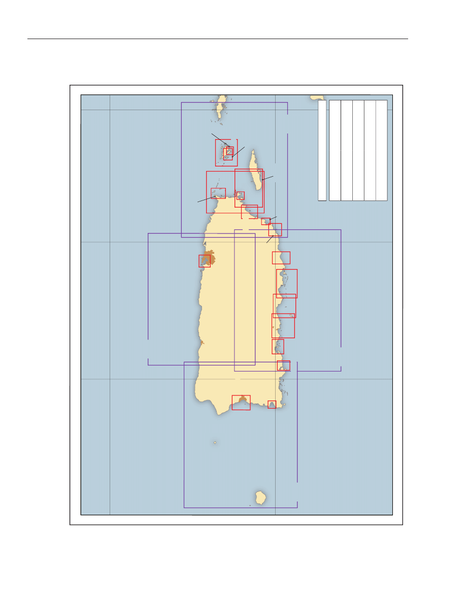
T
y
pe of Chart
Scale
HARBOR CHAR
TS
(outlined in red)
1:50,000 and larger
COAST
CHAR
TS
(outlined in purple)
1:50,001 to 1:150,000
GENERAL
CHAR
TS
(outlined in purple)
1:150,001 to 1:600,000
SAILING CHAR
TS
(outlined in purple)
1:600,001 and smaller
SMALL-CRAFT
CHAR
TS
(outlined in green)
1:800,000 and larger
25677
25671
25668
25650
25670
25663
25667
25664
25666
25665
25661
25689
25687
25685
25683
25681
25679
25675
25673
25659
25655
25654
25653
Puerto Rico
Cape San Juan
San Juan
Arecibo
Mayaguez
Ponce
Cabo Rojo
Isla de Culebra
Isla de V
ieques
Isla de Mona
Isla Desecheo
67°
67°
66°
66°
65°
65°
19°
19°
18°
18°
Caribbean Sea
Atlantic Ocean

Puerto Rico
(1)
This chapter describes the islands of the Common-
wealth of Puerto Rico, which includes Puerto Rico,
Mona, Vieques, Culebra, and a few smaller islands. Port
information is provided for San Juan, Fajardo, Radas
Roosevelt (Roosevelt Roads), Yabucoa, Laguna de Las
Mareas, Bahia de Jobos, Ponce, Guayanilla, Guanica,
Mayaguez, Arecibo, Isabel Segunda, Ensenada Honda,
and other smaller ports.
(2)
Nine hundred miles ESE of Key West, FL, is the is-
land of Puerto Rico, which was ceded to the United
States in 1898. Puerto Rico is the smallest and eastern-
most of the West Indies group known as the Greater
Antilles; the larger islands are Cuba, Jamaica, and His-
paniola. To the N of Puerto Rico is the Atlantic Ocean,
and on the S is the Caribbean Sea.
(3)
Puerto Rico formerly was administered under the
Jones Act of March 2, 1917, which extended United
States citizenship to all Puerto Ricans. On July 25,
1952, the island was formally proclaimed a Common-
wealth, voluntarily associated with the United States.
Puerto Rico is subject to the laws enacted by the Con-
gress of the United States. Under the Constitution of
Puerto Rico, the people of the Commonwealth elect a
governor and a legislature for 4-year terms. The Legis-
lature has an upper house, or senate, and a house of
representatives. The people also elect a Resident Com-
missioner who speaks in the U.S. House of Representa-
tives but does not vote.
(4)
Puerto Rico, the big island, is about 96 miles long,
W to E, and about 35 miles wide. The interior of Puerto
Rico is mountainous and very rugged. The highest
mountains are nearer the S and E coasts and have ele-
vations up to 4,400 feet. There are many fertile valleys,
and along the coasts are more or less narrow strips of
lowland from which the higher land rises abruptly.
(5)
The sea bottom is similar to the land. Close to the
island are narrow banks from which the bottom pitches
off rapidly to great depths. Under favorable conditions,
the shoals frequently are marked by a difference in the
color of the water.
Caution
(6)
Mariners are advised that local fishermen com-
monly mark the position of their fish nets and fishtraps
with plastic bleach bottles. Care should be taken to
avoid destroying this fishing gear.
(7)
Puerto Rico has several hundred streams, some of
good size, but none are navigable for anything but
small boats. The mouths of the streams generally are
closed by bars except during short periods of heavy
rainfall. From the location of the mountain divides, the
streams on the S and E sides of the island are short and
fall rapidly to the sea, whereas those on the N and W
sides are longer and slope more gently.
COLREGS Demarcation Lines
(8)
The lines established for Puerto Rico are described
in 80.738, chapter 2.
Vessel Traffic Management
(9)
(See Part 161, Subpart A, chapter 2, for regula-
tions requiring notifications of arrivals, departures,
hazardous conditions, and certain dangerous cargoes
to the Captain of the Port.)
Anchorages
(10)
Under ordinary conditions, the first requirement
for anchorage is shelter from the E trade winds. An-
chorages are numerous except along the N coast.
Strong N winds and heavy seas may occur from Novem-
ber to April. During the hurricane season gales may
strike from any direction. The best hurricane harbors
are Bahias San Juan, Guanica, Guayanilla, and Jobos,
and Ensenada Honda (on Isla de Culebra).
Currents
(11)
Along the Atlantic and Caribbean coasts of Puerto
Rico, the currents are greatly influenced by the trade
winds. In general, there is a W drift caused by prevail-
ing E trade winds; the velocity averages about 0.2 knot
and is said to be strongest near the island. A decided W
set has been noted near the 100-fathom curve along the
Caribbean coast from Isla Caja de Muertos to Cabo
Rojo. Offshore of Bahia de Tallaboa a current of 0.5 knot
has been observed setting NE across and against the E
wind. With variable winds or light trade winds it is
probable that tidal currents are felt at times along the
Atlantic and Caribbean coasts of Puerto Rico. Currents
are weak in the passage N of Isla Caja de Muertos and
Cayo Berberia.
(12)
Predictions of the tidal current in Canal de
Guanajibo and at three locations off the E coast of
Puerto Rico
■
Chapter 13
■
521

Puerto Rico may be obtained from the Tidal Current Ta-
bles. The times of slack water and of maximums of flood
and ebb in the middle of Canal de la Mona are 2 to 3
hours later than in Canal de Guanajibo. The times of S
and N currents in the passages E of Puerto Rico, as far
as Isla Culebrita, are believed to be about the same as
the times of W and E currents, respectively, in Pasaje de
Vieques.
(13)
In Canal de la Mona, on the NW end of the bank
about 13 miles W of Punta Guanajibo, there is a current
velocity of about 1 knot; slacks and strengths occur
about 15 minutes later than in Canal de Guanajibo.
(14)
In Sonda de Vieques, there are strong tidal currents
over the shoals in the W part and around Isla Cabeza de
Perro. In Pasaje de San Juan and Pasaje de Cucaracha,
estimated velocities of about 2 knots have been re-
ported. In the wider passages between Cayo Icacos and
Cayo de Luis Pena, it is estimated that the current ve-
locity is less than 1 knot. From Isla de Culebra the S
current sets toward Punta Este, Isla de Vieques, around
which tidal currents are strong.
(15)
In Canal de Luis Pena, the SE current is deflected N
of Bahia Tarja and thence sets toward the S end of Cayo
de Luis Pena; the current is weak off the entrance to
Bahia de Sardinas. The NW current sets directly
through the channel. The current velocity is about 2
knots.
Weather
(16)
Puerto Rico is a tropical, hilly island that lies di-
rectly in the path of the E trade winds. Bathed by waters
whose temperatures seldom drop below 80°F, the
coastal climate is mild year round, with a small daily
and annual temperature range. The rugged topography
does cause a wide variation over short distances in
wind, temperature, and rainfall.
(17)
The outstanding feature of the marine weather is
the steadiness of the E trade winds. NE through SE
winds blow about 80 percent of the time year round.
Easterlies are particularly dominant in summer when
the Bermuda High has shifted N. From November
through April, northeasterlies are the secondary direc-
tion, but give way to southeasterlies in spring. The
trade-wind regime is occasionally interrupted by cold
fronts that have survived a journey from the United
States and by easterly waves. As the cold front ap-
proaches, winds shift toward the S, and then as the
front passes they gradually shift through the SW and
NW quadrants back to the NE. The easterly wave pas-
sage is characterized by winds out of the ENE ahead of
it, followed by an ESE wind.
(18)
Gale-force winds are unlikely but can occur with a
strong front, thunderstorm, or tropical cyclone. Sum-
mer gales usually blow from the E semicircle, while
winter gales are more likely in the NE quadrant.
Windspeeds of 17 to 33 knots blow about 30 percent of
the time. In summer, the trades tend to strengthen
during the day, and average windspeeds are highest
during this season. Morning averages of 12 to 13 knots
give way to 13- to 15-knot averages during the after-
noon.
(19)
Near the coast, a land-sea breeze effect helps exert a
diurnal influence on the wind. If the pressure gradients
are weak, a land breeze may develop during the night;
northeasterly on the S coast and southeasterly on the N
coast. The sea breeze develops during the morning
hours and reinforces the trades on all but the W coast.
Along the W coast, it opposes the trades and tends to
weaken them.
(20)
Seas in the area usually run less than 8 feet. Waters
are roughest off the N and W coasts in winter and mid-
summer. For example, waves of 8 feet or more are en-
countered off these coasts 10 to 12 percent of the time
in July. High seas are usually associated with strong
winds out of the NE through SE blowing over a long
fetch of water. Extreme wave heights are generated by
hurricanes and can reach 40 feet or more in deep water.
(21)
The tropical cyclone season extends from June
through November. The most active period in this re-
gion is from August through the first half of October,
although “off-season” storms occasionally brush the
area. Most tropical cyclones affecting this area develop
E of the Lesser Antilles and move toward the W or NW.
They usually pass N or S of the island; occasionally they
pass directly over it as was the case of hurricane Geor-
ges in September 1998. In addition to strong winds and
rough seas, these storms can bring torrential rains and
flooding to the island. Georges raked the island from E
to W causing at least $2 billion in damages, 12 deaths,
destroyed at least 33,000 homes, and caused power and
water loss to nearly 80% of the island.
(22)
Another navigational weather hazard in these wa-
ters are thunderstorms. While they can occur in win-
ter, they are most likely from May through November.
At sea, they are encountered 2 to 7 percent of the time
during this period, while shore stations report thunder
on an average of 5 to 15 days each month during the
summer. In addition to strong gusty winds, heavy rains
may briefly reduce visibilities to near zero. However,
visibility problems are infrequent in these waters since
fog is a rarity.
(23)
(See Appendix B for San Juan climatological table.)
Routes
(24)
Vessels bound from Straits of Florida (24°25'N.,
83°00'W.) to San Juan can proceed by rhumb lines
through the following positions:
(25)
23°34'N., 80°26'W.;
522
■ Chapter 13
■
Volume 5

(26)
22°34'N., 78°00'W.;
(27)
22°07'N., 77°24'W.;
(28)
20°50'N., 73°43'W.;
(29)
19°45'N., 69°50'W.;
(30)
18°29'N., 66°08'W.
(31)
From the E coast of the United States, the route to
San Juan is direct by great circle.
(32)
Distances from San Juan are 1,017 miles to Straits
of Florida, 1,252 miles to Norfolk, 1,399 miles to New
York, and 1,486 miles to Boston.
Pilotage, Puerto Rico
(33)
Pilotage is compulsory for all foreign vessels and
U.S. vessels under register when entering or leaving
the harbors of Puerto Rico. Coastwise vessels having on
board an officer licensed as a pilot for the waters of
Puerto Rico and all pleasure yachts are exempt from pi-
lotage unless a pilot is actually engaged. The pilot ser-
vice at each port is under the supervision and direction
of a Commonwealth Captain of the Port; ships’ agents
should notify his local office in advance so a pilot will be
available at the expected time of arrival of a vessel. Pi-
lots provide 24-hour service and board vessels from
motorboats. Detailed information on pilotage proce-
dures is given in the text for the ports concerned.
Towage
(34)
Large tugs are available at San Juan, Puerto
Yabucoa, and Bahia de Guayanilla; smaller tugs are
available at some of the other ports. Arrangements for
tugs should be made in advance by ships’ agents. (See
the text for the ports concerned as to the availability of
tugs.)
Quarantine, customs, immigration, and agricultural
quarantine
(35)
Quarantine is enforced in accordance with regula-
tions of the U.S. Public Health Service. (See Public
Health Service, chapter 1.)
(36)
Puerto Rico collects no customs duties on mer-
chandise entering the island from the continental
United States or its dependencies. Merchandise entering
from foreign countries is subject to the duties of the
United States, which are collected at the ports of Puerto
Rico by the U.S. Customs Service. Ports of entry are
listed in Appendix A. At least 24-hours’ advance notice
of arrival at a port should be given to the local customs
officer.
(37)
Agricultural quarantine laws are enforced by offi-
cials at San Juan, Fajardo, Ponce, and Mayaguez. The
United States immigration laws apply to Puerto Rico.
Passports and visas are required. In 2007, it was re-
ported that Ramey Air Force Base no longer exists and
Roosevelt Roads Naval Air Station closed.
(38)
The United States immigration laws apply to
Puerto Rico. Passports and visas are required.
Ports Authority
(39)
The control of all the ports of Puerto Rico is vested
in the Commonwealth Government whose authority is
exercised through the Puerto Rico Ports Authority. Ap-
pointed Commonwealth Captains of the Port have ad-
ministrative charge of the harbors; they collect the port
fees and assign vessels to anchorage or to berths along-
side wharves.
(40)
At ports where commonwealth and federal officials
are not stationed, inspectors usually come from the
nearest represented port or from San Juan as required.
Wharves
(41)
The ports of San Juan, Yabucoa, Laguna de Las
Mareas, Ponce, Bahia de Tallaboa, Bahia de Guayanilla,
Ensenada (Bahia de Guanica), Mayaguez, and Aguadilla
all have wharves where large vessels can go alongside
to load and unload cargo. At the other ports, the
wharves are only used by small vessels.
Supplies
(42)
All kinds of supplies are available at San Juan,
Ponce, and Mayaguez. Gasoline, water, and marine sup-
plies are available at most of the smaller ports. If neces-
sary, supplies can be trucked from San Juan in a few
hours.
Repairs
(43)
San Juan is the only port where major repairs to
large ocean-going vessels can be made. Available are a
691-foot graving dock and two marine railways for me-
dium-sized vessels. Ordinary repairs to machinery can
be made at Ponce and Mayaguez. Small vessels, motor-
boats, and yachts can be repaired at some of the mari-
nas around the island.
Communications
(44)
There are good highways to all the principal cities,
and roads connect the smaller towns. Regular air ser-
vice is maintained between San Juan, Ponce, and
Mayaguez. Air service is also available from San Juan to
the Virgin Islands, the United States, and some foreign
countries.
(45)
Many cruise lines operate from San Juan, Ponce,
and Mayaguez to the United States and foreign ports.
Small inter-island vessels operate from most of the
ports of Puerto Rico to the Virgin Islands and other
West Indies ports.
(46)
Telephone is available through all the ports of
Puerto Rico. Radio communication to all points, in-
cluding ships at sea, is available through commercial
Puerto Rico
■
Chapter 13
■
523

systems. The Commonwealth Government maintains
radio telegraphic service between San Juan and the is-
lands of Culebra and Vieques.
Currency
(47)
The monetary unit is the United States dollar.
Standard time
(48)
Puerto Rico uses Atlantic standard time, which is 4
hours slow of Greenwich mean time. Puerto Rico does
not observe daylight saving time.
Language
(49)
Spanish is the official language of Puerto Rico, al-
though many of the native people are bilingual; most of
the island’s geographic features have Spanish names.
English is a required subject in the schools and is pre-
ferred for business purposes by a large part of the com-
mercial community.
(50)
Spanish-English Geographic Glossary:
(51)
Agua-water
(52)
Amarillo-yellow
(53)
Anclaje, Ancladero-anchorage
(54)
Arena-sand
(55)
Arrecife-reef
(56)
Arroyo-small stream
(57)
Bahia-bay
(58)
Bajo-shoal
(59)
Banco-bank
(60)
Barra-bar
(61)
Blanco-white
(62)
Boca-mouth, entrance
(63)
Boqueron-wide mouth
(64)
Cabeza-shoal head
(65)
Cabezo-summit of hill
(66)
Cabo-cape
(67)
Caleta-cove
(68)
Canal-channel
(69)
Cano-creek, channel
(70)
Castillo-castle
(71)
Cayo-key
(72)
Cerro-hill
(73)
Cienaga-marsh
(74)
Cordillera-mountain chain
(75)
Costa-coast
(76)
Desembarcadero-landing
(77)
Embarcadero-wharf, quay
(78)
Ensenada-bay, cove
(79)
Escollo-shelf, reef
(80)
Este-east
(81)
Estero-creek, inlet
(82)
Estrecho-strait
(83)
Exterior-exterior
(84)
Farallon-rocky islet
(85)
Golfo-gulf
(86)
Gran, Grande-great
(87)
Interior-interior
(88)
Isla-island
(89)
Isleta-islet
(90)
Istmo-isthmus
(91)
Lago-Lake
(92)
Laguna-Lagoon
(93)
Laja-flat rock
(94)
Largo-long
(95)
Mar-sea
(96)
Medio-middle
(97)
Meridional-southern
(98)
Monte, Montana-mountain
(99)
Morro-headland, bluff
(100)
Negro-black
(101)
Norte-north
(102)
Nuevo-new
(103)
Occidental-western
(104)
Oeste-west
(105)
Oriental-eastern
(106)
Pantano-marsh
(107)
Pasaje-passage
(108)
Peninsula-peninsula
(109)
Pico-peak
(110)
Piedra-stone, rock
(111)
Playa-beach
(112)
Pueblo-town
(113)
Puerto-port, harbor
(114)
Punta-point
(115)
Rada-roadstead
(116)
Rincon-inside corner
(117)
Rio-river
(118)
Roca-rock
(119)
Rojo-red
(120)
Septentrional-northern
(121)
Sierra-mountain range
(122)
Sonda-sound
(123)
Sur-south
(124)
Tierra-land
(125)
Verde-green
(126)
Viejo-old
Chart 25640
(127)
Canal de la Mona (Mona Passage), 61 miles wide
between the W end of Puerto Rico and the E end of His-
paniola, is one of the principal entrances to the Carib-
bean Sea. Three small islands are located in the
passage: Isla de Mona and Isla Monito about midway in
the S part, and Isla Desecheo about 12 miles W of the
extremity of Puerto Rico in the N part.
524
■ Chapter 13
■
Volume 5

(128)
On the W side of Canal de la Mona, a bank extends
from Cabo Engano, the E extremity of Hispaniola, for
23 miles, with a least depth of 26 fathoms. Depths of 5
to 20 fathoms have been reported on the bank about 7
miles SSE of Cabo Engano (chart *25008). Strong tide
rips and heavy swells, caused by the meeting of con-
trary currents, are visible for many miles and mark the
position of this bank. On the E side of the passage, an
extensive bank makes off from the W coast of Puerto
Rico extending up to 15 miles offshore. The W coast of
Puerto Rico is described later in this chapter.
Currents
(129)
Tidal currents set generally S and N through Canal
de la Mona. Varying nontidal flows, depending to a
great extent upon the velocity and direction of the
wind, combine with the tidal current. An average
nontidal current of about 0.2 knot setting approxi-
mately NNW is generally experienced during all sea-
sons. In summer, when the trade wind has slackened
and blows more from the E and ESE, a strong
countercurrent sets E off the S coast of Hispaniola.
This countercurrent occasionally induces a N set in the
passage.
(130)
A 3.5-knot current, setting approximately WSW,
has been reported in the passage N of Isla de Mona. Ob-
servations made on the NW edge of the bank about 13
miles W of Punta Guanajibo, Puerto Rico, gave a veloc-
ity of about 1 knot for both S and N strengths.
(131)
The tidal currents also set with considerable veloc-
ity, especially near the shore S of Cabo Engano, where
they have been reported to set with a velocity of 3.5
knots during the month of May, with ebb currents set-
ting NE for 3 hours and flood currents setting SW for 9
hours. The duration of these currents has also been re-
ported to be the reverse, and at other times to be of the
usual duration of 6 hours.
(132)
The passage presents little difficulty in navigation,
except that caution must be used in the vicinity of Isla
Saona off the SE coast of Hispaniola, which is low and
foul. This island should be given a berth of at least 6
miles. Heavy squalls may be expected in the passage,
particularly in the summertime.
Chart 25671
(133)
Isla de Mona (18°05'N., 67°54'W.), 6 miles long E
and W and 4 miles wide, lies in the middle of the S part
of Canal de la Mona. Temporary anchorage and landing
can be made in places on the S and W sides of the island
during good weather, but on many days anchorage and
landings are impracticable. The attendants for the
Puerto Rico Department of Natural Resources and a
State police detachment are the only inhabitants of the
island.
(134)
The island is composed of limestone and from E ap-
pears perfectly flat on top, breaking off abruptly at the
water in a vertical whitish cliff about 175 feet high. On
the NW and NE coasts are extensive caves that run in
every direction but are so obstructed by stalactites and
stalagmites in places that it is almost impossible to
pass. They were used as hideouts by pirates for nearly
three centuries. The W, S, and SE sides of the island are
fringed with detached coral reefs through which boat
passages lead.
(135)
The 100-fathom curve lies about 1 mile offshore,
except on the SE side, where it is about 1.7 miles off,
and on the SW side, where it is only about 0.3 mile off.
With a strong wind from any direction, the sea draws
around the island and generally into all the anchor-
ages. Anclaje Sardinera, on the W coast, is the best an-
chorage during SE winds, and Anclaje Isabela, just S of
Punta Arenas, is good during NE winds. Boat landings
can be made at Anclaje Sardinera and Playa de Pajaros.
(136)
Isla de Mona and Isla Monito are within a Desig-
nated Critical Habitat for the Hawksbill Sea Turtle.
(See 50 CFR 226.101 and 226.209, chapter 2, for reg-
ulations and limits.)
Currents
(137)
In Anclaje Sardinera the tidal currents set N and S
with a velocity of about 0.5 knot. A northerly current
with a velocity of 0.5 knot has been experienced off
Playa de Pajaros.
(138)
Isla de Mona Light (18°06'36"N., 67°54'30"W.), 323
feet above the water, is shown from a tower near Cabo
Noroeste on the N side of the island. The structure of
the former Isla de Mona Light on Punta Este, the E ex-
tremity of the island, remains.
(139)
Vertical cliffs with deep water close to shore extend
from Punta Este N and W to Cabo Barrionuevo, the NW
cape of the island. Here a mass of rock, shaped like two
saw teeth on top, projects from the base of the cliff. This
feature can be observed from N and SW.
(140)
Playa de Pajaros, about 1.5 miles SW of Punta Este,
has a boat harbor with 3 to 8 feet of water inside the
reefs. The S and main entrance has reported depths of 7
to 12 feet. The landing place, formerly used by Coast
Guard vessels, has 7 to 8 feet alongside, but with S
winds a swell sets into the landing.
(141)
The southernmost point of the island is sur-
mounted by a large balanced rock. Punta Arenas
(Oeste), the westernmost point, is a low, narrow ridge,
covered with brush, which projects nearly a mile W of
the cliffs; a reef extends 0.3 mile W of the point.
Puerto Rico
■
Chapter 13
■
525

(142)
Isla Monito, 3 miles NW of Isla de Mona, is a
213-foot high bare rock 0.2 mile in diameter. The pas-
sage between the two islands is deep and clear.
(143)
Isla Desecheo, 27 miles NE of Isla de Mona and 12
miles W of Punta Higuero, is a 715-foot high wooded is-
land a mile in diameter. The island is visible for more
than 30 miles in clear weather and is one of the best
landmarks for Canal de la Mona and the W coast of
Puerto Rico. Isla Desecheo is a forest reserve and a na-
tive-bird reserve; it is uninhabited and has no anchor-
ages along its shores.
(144)
The U.S. Navy has advised that a survey (1974) of
Isla Desecheo and adjacent waters revealed the pres-
ence of unexploded ordnance resulting from past usage
as a target area. Mariners are urged to use extreme cau-
tion when in this area.
(145)
Punta Higuero, the most W point of the mainland
of Puerto Rico, is projecting and prominent with the
land back of it rising abruptly to rolling hills which as-
cend gradually to Pico Atalaya, 6 miles inland to the
SE. Punta Higuero Light (18°21'42"N., 65°16'12"W.),
90 feet above the water, marks the end of the point.
(146)
Steep-to reefs with less than 12 feet of water over
them extend up to 0.4 mile offshore from Punta
Higuero to beyond Punta Borinquen to the NE.
(147)
Bahia de Aguadilla, 7 miles NE of Punta Higuero, is
exposed N and W, but with ordinary E trade winds an-
chorage is smooth. There are frequent rough spells
during the winter when the wind is from N.
(148)
Aguadilla is on the E shore of the bay. Radio towers
S of the town are prominent. The 1,208-foot-high naval
communication tower (18°24.0'N., 67°10.6'W.) is the
most prominent feature from offshore. The small white
shaft of the Columbus Monument is about 1 mile S of
city hall, but is completely obscured by palm trees.
(149)
Large vessels load raw sugar and molasses at the
conveyor pier with mooring buoys and dolphins 1.1
miles N of Aguadilla; depths of 40 feet or more are at
the outer end of the pier.
(150)
A U.S. Air Force fuel pier, with pipelines for han-
dling aviation fuels, is 1.8 miles N of Aguadilla. Depths
of 30 feet were reported alongside the platforms at the
outer end of the pier. Depths of 6 feet and less were re-
ported alongside the emergency crash boat basin finger
piers that extend off the SE end of the fuel pier.
Pilotage, Bahia de Aguadilla
(151)
Pilots for Bahia de Aguadilla are available at
Mayaguez. See Pilotage, Puerto Rico (indexed as such)
early this chapter.
Quarantine, customs, immigration, and agricultural
quarantine
(152)
(See chapter 3, Vessel Arrival Inspections, and Ap-
pendix A for addresses.)
(153)
Quarantine is enforced in accordance with regula-
tions of the U.S. Public Health Service. (See Public
Health Service, chapter 1.)
(154)
Aguadilla is a customs port of entry.
Coast Guard
(155)
A U.S. Coast Guard air station is at Borinquen Air-
port, N of Aguadilla.
Fish haven
(156)
A fish haven with an authorized minimum depth of
11 fathoms is about 1.8 miles NW of Aguadilla in
18°27'30"N., 67°10'06"W.
Chart 25671
(157)
The N coast of Puerto Rico from Canal de la Mona
to San Juan extends in an almost E direction for 60
miles. From Punta Borinquen for 27 miles to Arecibo,
there are numerous rocky cliffs with sand beaches and
dunes between them. The prominent features are the
high hills in the interior and high cliffs along the coast.
The hills that terminate a mile W of Arecibo are mostly
smooth grassy slopes backed by conical wooded hills up
to 800 feet high.
(158)
Between Arecibo and San Juan, the coast is in-
dented by several coves and bights, although none of
them afford sheltered anchorage. The first 17 miles to
nearly Punta Puerto Nuevo consists of sandy beaches
and dunes with occasional rocky bluffs, then there are
numerous hummocks and rocky bluffs with short
beaches between them in the 16-mile stretch to San
Juan. A line of breakers enclosing numerous rocks lies
as close as 0.5 mile offshore. A range of conical hills is
W of San Juan.
(159)
In addition to the marine and aerolights near
Punta Borinquen, the marine lights at Arecibo and San
Juan, several stacks, radio towers, and towns are prom-
inent from offshore along the N coast. All dangers will
be avoided by staying a mile or more offshore.
(160)
Punta Borinquen, at the NW end of Puerto Rico, is
steep-to with deep water within 0.5 mile of shore, but
vessels should stay several miles offshore because of a
small arms firing area in the vicinity of the light. The
extreme W part of the point is low, but it is backed by
steep wooded slopes 0.5 mile inland.
(161)
Punta Borinquen Light (18°29'48"N., 67°08'54"W.),
292 feet above the water, is shown from a 60-foot gray
526
■ Chapter 13
■
Volume 5

cylindrical tower. A 200-foot rock bluff begins 0.8 mile
SW of the light and extends NE and E along the N coast
of Puerto Rico.
(162)
A boat landing may be made in calm weather in the
sandy cove on the W side of Punta Sardina, 7.3 miles E
of Punta Borinquen Light.
Chart 25668
(163)
Punta Penon, 16 miles E of Punta Borinquen
Light, is a slight projection with lower land between it
and the foothills. A rocky islet lies W of the point and a
chain of bare rocks and a small islet extend 0.8 mile E of
it.
(164)
Puerto Arecibo, 26 miles E of Punta Borinquen
Light and 33 miles W of San Juan, is an open bight
somewhat protected by the headland of Punta
Morrillos on the E side with a 1,200-foot breakwater ex-
tending from it to Roca Cocinera. Only fishing vessels,
pleasure craft, and a chemical supply barge use the
port. Arecibo is along the SW shore of the bight.
(165)
Arecibo Light (18°28'55"N., 66°41'55"W.), 120 feet
above the water, is shown from a 120-foot white hexag-
onal tower attached to a dwelling on the hill close to
the shore near the N end of Punta Morrillos. Radio tow-
ers and stacks are prominent around Arecibo.
(166)
A dredged channel, marked by buoys, leads from
the Atlantic Ocean to a bulkhead wharf on the S side of
the breakwater of Puerto Arecibo. In 2008, a depth of
19.8 feet was available in the entrance channel with 3.3
to 18.1 feet in the basin off the wharf.
(167)
The 400-foot bulkhead wharf had depths of about
18.1 feet alongside in 2008, and much lesser depths at
the upper or inner end.
(168)
A pipeline on the wharf is used by barges to supply
liquid chemicals to storage tanks of a chemical com-
pany. Gasoline can be obtained at the wharf in an emer-
gency. Fishing vessels and small craft anchor S of the
wharf.
(169)
Danger zones for artillery and small-arms ranges
extend up to 10 miles offshore in the vicinity of Punta
Puerto Nuevo, 42 miles E of Punta Borinquen Light.
(See 334.1450, chapter 2, for limits and regulations.)
(170)
A boat landing can be made in calm weather inside
the rock islets that extend a mile W of Punta Puerto
Nuevo. An aero radiobeacon (18°28.2'N., 66°24.8'W.),
marked by a flashing red light, is prominent SW of
Punta Puerto Nuevo.
(171)
Several large dome-shaped structures are promi-
nent on Punta Salinas, a narrow projecting point 3
miles W of San Juan. A large blue water tank, 1.9 miles
inshore of the point, shows up well from offshore.
Chart 25670
(172)
Bahia de San Juan, the most important commer-
cial harbor in Puerto Rico, is about 60 miles E of Punta
Borinquen and 30 miles W of Cabo San Juan. It is the
only harbor on the N coast which affords protection in
all weather. It is protected on the N by the relatively
high land of Isla San Juan, and on the S, E, and W by the
adjacent low mangrove swamps of the Puerto Rico
mainland.
(173)
The bay is about 3 miles long in a SE direction and
varies in width from 0.6 to 1.6 miles, but the entire SW
side is shoal. The SW shore is divided into two large
bights by Punta Catano, the point which extends about
0.6 mile NE into the harbor.
(174)
Metropolitan San Juan, the capital and principal
port of Puerto Rico, includes Isla San Juan on the N
side of Bahia de San Juan and the communities sur-
rounding the bay. The principal cruise tourism facili-
ties are on the S side of Isla San Juan (Old San Juan)
and on the N side of Isla Grande. Container cargo ter-
minals are located at Puerto Nuevo in the SE part of the
bay.
(175)
The principal imports into the harbor include food-
stuffs, textiles, building materials, machinery, fertiliz-
ers, and petroleum products. Exports include sugar,
molasses, fruit, tobacco, coffee, petrochemicals,
pharmaceuticals, and alcoholic products. Over half the
commerce of Puerto Rico passes through San Juan.
Most commercial and government activities are lo-
cated here.
Prominent features
(176)
Isla de Cabras, on the W side of the entrance to
Bahia de San Juan, is low with cliffs 32 to 36 feet high at
its N end and is marked by a light on its NW end. Las
Cabritas are three small islands and rocks 0.1 mile NE of
the island. The island is connected to the mainland by a
causeway at Punta Palo Seco. A small stone structure of
El Canuelo is on the S extremity of Isla de Cabras.
(177)
Isla San Juan, on the E side of the entrance to the
harbor, is generally bold and rocky, with a ridge 100 feet
high extending along its N side. At each end of the is-
land are large stone forts connected by a continuous
high wall. Fort San Cristobal is on the summit of the
ridge in the E part, and Castillo del Morro is on the ex-
treme W point of the island at the entrance to the har-
bor and is protected by a breakwater. The city wall
extends from the castle along the channel side of the is-
land to the Governor’s Palace.
(178)
Puerto San Juan Light (18°28'24"N., 66°07'24"W.),
181 feet above the water, is shown from a 51-foot buff
tower on the summit of Castillo del Morro.
Puerto Rico
■
Chapter 13
■
527

(179)
The white marble dome of the capitol building, 1
mile E of the light, and a white church 0.4 mile farther
E are prominent landmarks.
(180)
Several tanks and towers, as well as the dome of a
convention center, are prominent on Island Grande; an
aerolight is shown from a small air traffic control tower
about 750 yards SE of its NW end. Many radio towers,
stacks, and tanks surround Bahia de San Juan.
COLREGS Demarcation Lines
(181)
The lines established for San Juan are described in
80.738, chapter 2.
Channels
(182)
Bar Channel, the entrance channel to Bahia de San
Juan, leads to the deep-draft anchorage SW of Isla
Grande, via Anegado Channel; Federal project depth in
Bar and Anegado Channels, and the deep-draft anchor-
age is 40 feet. San Antonio Channel, project depth 35
feet, leads from Anegado Channel between Isla San
Juan and Isla Grande, to the commercial piers and the
Navy berthing facilities on the S side of Isla San Juan,
and to the Isla Grande marginal wharf and the Seatrain
Lines container terminal on the N side of Isla Grande.
The Army Terminal Channel leads S from Anegado
Channel to the Army Terminal and turning basin,
Puerto Nuevo Terminal bulkhead wharves, and to the
oil piers at the S end of the harbor; project depths in the
Army Terminal Channel and turning basin are 40 feet.
Graving Dock Channel and turning basin, S of Isla
Grande, leads from Anegado Channel; project depths in
Graving Dock Channel and turning basin are 36 feet.
Puerto Nuevo Channel, project depth 39 feet, in the SE
part of the harbor, connects Army Terminal Channel
with Graving Dock Channel. (See Notice to Mariners
and latest editions of charts for controlling depths.)
(183)
The entrance channel and the channels inside the
harbor are marked by lighted ranges, lights, and
lighted and unlighted buoys.
Caution
(184)
When approaching the entrance channel (Bar
Channel), with quartering and following seas which are
especially predominant in winter, speeds of not less
than 10 knots are recommended. This requirement for
speed permits sufficient time to commence turning
into Anegado Channel while maintaining ship control.
An additional cause of confusion and groundings is
that the N side Anegado Channel markers are not visi-
ble, virtually, until the turn into it should already have
been commenced. Positive identification of channel
marks is imperative.
(185)
Vessels should proceed with caution when dredg-
ing is in progress in the channels. (See 162.260, chap-
ter 2, for regulations.)
(186)
An unmarked channel leads to a landing pier at the
NE end of the causeway between Isla de Cabras and
Punta Palo Seco; depths of about 4 feet can be carried.
The channel and pier are used by craft handling dan-
gerous or explosive cargoes.
(187)
Cano de Martin Pena, at the SE end of Bahia de San
Juan, is a narrow slough that connects with lakes and
lagoons which extend E for 7 miles. A channel with a
reported depth of 3 feet extends 1.5 miles above the en-
trance. A fixed bridge at the entrance to the slough has
a clearance of 21 feet. Two overhead cables about 0.5
mile above the entrance have a least clearance of 31
feet. Two fixed highway bridges 0.75 mile above the en-
trance have a least clearance of 22 feet. The bridges 1.5
miles above the entrance, the head of navigation, have
a least width of 44 feet and a clearance of 7 feet.
Anchorages
(188)
General and special anchorages are in Bahia de San
Juan. (See 110.1, 110.74c, and 110.240, chapter 2 for
limits and regulations.) In 1965, a controlling depth of
26 feet was in Anchorage F, on the SW side of Anegado
Channel with shoaling to 24 feet in the S 100 yards of
the anchorage. A line of mooring dolphins, marked by
lights, extends from Isla Grande to just outside the E
end of Anchorage E.
Dangers
(189)
Bajo Colnas, on the W side of the entrance to Bahia
de San Juan, has depths of 18 feet and less extending
700 yards from Isla de Cabras. The shoal area is usually
defined by breakers.
(190)
Bajo Santa Elena, on the E side of the entrance,
has depths of 7 to 18 feet extending 200 yards from
shore.
(191)
Inside the harbor, the areas outside the channel
limits marked by buoys are shallow with depths varying
from 4 to 18 feet with many shoals having less than 1
foot over them.
Currents
(192)
The currents along the N shore of Puerto Rico are
greatly influenced by the direction and strength of the
winds. The prevailing E trade winds generally cause a
W drift. In Bahia de San Juan a slight W flow prevails.
When N seas set into the harbor entrance, an undertow
and surge may be felt as far as San Antonio Channel.
Weather
(193)
San Juan is located on the NE coast of the island of
Puerto Rico in 18°28'N., 66°07'W. It is surrounded by
528
■ Chapter 13
■
Volume 5

the waters of the Atlantic Ocean and Bahia de San Juan.
Santurce, directly to the E of Bahia de San Juan, is the
urbanized section of San Juan. The surrounding ter-
rain is level with a gradual upslope inland. Mountain
ranges, with peak elevations of 4,000 feet, extend E and
W through the central portion of Puerto Rico, and are
located 15 to 20 miles E and S of the capital city. This
mountain range has a decided influence on the rainfall
in the San Juan area, especially summertime thunder-
storms.
(194)
The climate is tropical marine, slightly modified by
insular influences when land breezes blow. Radiational
cooling frequently causes land winds at night, conse-
quently, somewhat lower nightime temperatures occur
than would normally be experienced with sea breezes.
This air drainage from the higher altitudes in the inte-
rior of the island to the coastal areas gives delightfully
invigorating night temperatures, especially during De-
cember to March, inclusive. Minimum temperatures
during this period are frequently 2° to 3° higher within
the city than at Isla Verde Airport, which is located 6.5
miles E and slightly inland. By the same token, maxi-
mum temperatures are 1° to 2° lower in the city.
(195)
San Juan has a small annual temperature range,
which is a characteristic of all tropical marine climates.
The difference between the average temperatures of
the warmest and coolest months is about 5.8°F in San
Juan, and is representative of most of the coastal locali-
ties in the island. The average temperature at San Juan
is 80.4°F with an average maximum of 86.4°F and an
average minimum of 73.8°F. The small seasonal varia-
tion in temperature is also true concerning the abso-
lute range of temperature. For the San Juan-Isla Verde
Airport area, the highest temperature of record is 98°F
recorded in October 1981 and lowest, 60°F recorded in
March 1959.
(196)
San Juan’s average annual rainfall is 53 inches,
with fairly even distribution throughout the year. May
is the wettest month averaging 5.97 inches and Febru-
ary is the driest averaging 2.26 inches. At Isla Verde Air-
port, about 12 miles W of this mountain range, the
annual rainfall is about 64 inches. The heavier monthly
amounts normally occur during the period from May to
December, inclusive. Rainfall is generally of the show-
ery type except for the continuous rains which occur in
connection with the passage of tropical storms, or
when the trailing edge of a cold front which has swept
across the continental United States penetrates far
enough S to have a definite effect upon Puerto Rico
rainfall. This infrequently occurs from November to
April. Sunshine is plentiful, with only an average of 5
days a year entirely without sunshine, although there is
an average of 255 days a year with measurable precipi-
tation. The average duration of the showers is not more
than 10 to 15 minutes, although on many occasions,
especially in the summer a series of intermittent show-
ers will extend over a period of an hour or two. Being
marine, the climate is naturally humid. Relative hu-
midity averages about 85 percent in the nighttime and
65 percent near midday. Dense fogs never occur in the
San Juan area.
(197)
The E trade winds, aided by the daily recurrence of
the land and sea breezes constitute the most character-
istic feature of the climate for San Juan throughout the
year. The wind is almost constantly from the ocean dur-
ing daylight. Usually, after sunset the wind shifts to the
S or SE, off the land. This daily variation in the circula-
tion pattern of surface winds is a contributing factor to
the delightful climate of the island. The seawater tem-
perature about San Juan ranges from a minimum of
78°F in March to a maximum of about 83°F in Septem-
ber.
(198)
Heavy N winds pile up heavy seas and breakers in
the harbor entrance.
(199)
Puerto Rico is in the tropical hurricane region of
the E Caribbean where the season for these storms be-
gins June 1 and ends November 30. Several hurricanes
affect this area every season, usually passing the area to
the N. In 1928, the National Weather Service’s ane-
mometer blew away after recording an extreme wind
speed of 139 knots, the highest value in Puerto Rico to
date. A hurricane caused considerable loss of life and
great property damage in San Juan on September 26,
1932 and on August 12, 1956, Hurricane Betsy passed
over Puerto Rico. Hurricane winds were felt at San
Juan, but there was no loss of life reported, and prop-
erty damage was not great. Hurricane Marilyn passed
about 75 km E of the city in September 1995. While
causing much damage in the nearby U.S. Virgin Is-
lands, Marilyn provided wind gusts of 100 knots for the
San Juan region. Hurricane Hugo passed very close to
the city in September 1989 with 110-knot wind gusts.
Since 1950, 11 tropical systems have come within 50
miles of San Juan. In most recent memory, hurricane
Georges caused major damage as it crossed Puerto Rico
from E to W in September 1998. Georges was discussed
earlier in the chapter.
(200)
Mild temperatures, refreshing sea breezes in the
daytime, plenty of sunshine, and adequate rainfall
make the climate of San Juan enjoyable and exception-
ally favorable for tourists and visitors.
(201)
The National Weather Service maintains an office
at Isla Verde International Airport; barometers may be
compared there.
(202)
(See Appendix B for San Juan climatological table.)
Puerto Rico
■
Chapter 13
■
529

Routes
(203)
Owing to the swells and currents on the coast of
Puerto Rico, especially during the winter northerlies,
inbound vessels should steer for a point about 4 miles N
of Punta del Morro, the NW point of Isla San Juan, be-
fore lining up on the entrance to Bahia de San Juan.
This precaution permits early adjustments to course
and speed while still having sea room to do so. A
187°45' lighted range and lighted buoys mark the en-
trance channel into the harbor.
(204)
From W, Punta Salinas (chart 25668) will appear as
an island when first sighted and must not be mistaken
for Isla de Cabras.
(205)
The harbor is easy of access in ordinary weather,
but it should not be entered at night without local
knowledge. During winter northers, dangerous condi-
tions may prevent entering the harbor. The bend inside
the entrance can be difficult when the NE trades are
blowing strongly, as they may force a vessel almost
broadside to swells. Vessels outbound should avoid get-
ting too close to Bajo Colnas; this is particularly so with
long vessels in a strong N breeze.
Signal Station
(206)
It is advised by the Puerto Rico Ports Authority that
the signalling station at Isla de Cabras is manned
around the clock. All vessels equipped with radiotele-
phone approaching to enter Bahia de San Juan shall, at
a safe distance not less than 3 miles N of the sea buoy,
use the call and reply VHF-FM channel 16 and the
working channel 14 to call San Juan Port Control and
obtain clearance to proceed inside the harbor.
(207)
Vessels about ready to leave their berths and pro-
ceed out to sea shall, prior to departure, call the signal
station on the regular call and reply channel, then
switch over to the working channel to obtain clearance
to depart.
(208)
All vessels, particularly tugs with a tow, are cau-
tioned to closely follow the procedure herein above in-
dicated to avoid close quarters and risk of collision
situations in the Bar and Anegado Channels.
Pilotage, Bahia de San Juan
(209)
See Pilotage, Puerto Rico (indexed as such) early
this chapter. Pilotage can be arranged by contacting
the pilot station on VHF-FM channel 14, by telephone
787-722-1169, or by email at sjbaypilots@prtc.net. Pi-
lot services are generally arranged for at least 24 hours
in advance through the ships’ agents. If advance ar-
rangements have not been made a minimum of 2
hours’ notice is required.
(210)
Pilots board vessels 3 miles off the harbor entrance
from motorboats which are painted black with white
tops and have the word PILOT or the letter “P” in white
on both sides of the bow; 24-hour service is available.
(211)
Vessels requiring pilot services are advised to navi-
gate with caution and maintain a safe distance, never
closer than 3 miles in a generally N direction from the
harbor entrance, and hold that distance until boarded
by the pilot. When small-craft warning signals are dis-
played, with heavy seas breaking outside, the harbor is
difficult and dangerous to negotiate and the arrival of
the pilot on board may be considerably delayed. Pilot
boats communicate over the same frequencies as the
San Juan Port Control on Isla de Cabras via individual
walkie-talkie sets; i.e., call and reply frequency
VHF-FM channel 16 and working frequency VHF-FM
channel 14. When there are no English speaking people
on board the pilot boat, messages may be relayed
through the San Juan Port Control at Isla de Cabras.
Towage
(212)
Tugs up to 6,000 hp are available for docking,
undocking, and up to 9,000 hp for long-distance towing
and salvage. Use of tugs is compulsory for docking and
undocking vessels of 8,000 tons displacement and over
unless equipped with bow or side thrusters.
Quarantine, customs, immigration, and agricultural
quarantine
(213)
(See chapter 3, Vessel Arrival Inspections, and Ap-
pendix A for addresses.)
(214)
Quarantine is enforced in accordance with the reg-
ulations of the U.S. Public Health Service. (See Public
Health Service, chapter 1.) San Juan has several hospi-
tals.
(215)
San Juan is a customs port of entry.
Coast Guard
(216)
A Sector Office is in San Juan. (See Appendix A for
address.) A security zone has been established off the
coast of La Puntilla in San Juan Harbor around the San
Juan Coast Guard sector office. (See 165.776, chapter
2, for limits and regulations.)
Harbor regulations
(217)
The Commonwealth Captain of the Port enforces
the local rules and regulations for Bahia de San Juan.
His office is located on Isla Grande.
Wharves
(218)
The port of San Juan has numerous wharves and
piers of all types, most of which are owned by the
Puerto Rico Ports Authority. Only the major deepwater
facilities are described, and these are located on the S
side of Isla San Juan, the N and S sides of Isla Grande,
along the S side of Puerto Nuevo Channel, and
530
■ Chapter 13
■
Volume 5

alongside the Army Terminal Turning Basin at the S
end of the harbor. The port has over 200,000 square feet
of transit sheds, 1.5 million square feet of open storage,
and 73 acres of marshaling yards. Most of the piers have
freshwater connections and access to highways; shore
power is not available. Cargo is generally handled by
ships’ tackle; special cargo handling equipment, if
available, is mentioned in the description of the partic-
ular facility. The alongside depths given for each facil-
ity described are reported; for information on the latest
depths, contact the operator.
(219)
S side of Isla San Juan:
(220)
Pier 1 (26°27'50"N., 66°06'50"W.): 770 feet of berth-
ing space E and W sides; 27 feet alongside; berthing for
cruise ships; operated by Puerto Rico Ports Authority.
(221)
Wharf 5: 200 yards E of Pier 1; 695 feet long; 30 feet
alongside; operated by Puerto Rico Ports Authority.
(222)
Wharf 6: 500 yards E of Pier 1; marginal wharf, 955
feet long; 30 feet alongside; cruise ship terminal;
Puerto Rico Pilotage Commission offices; operated by
Puerto Rico Ports Authority.
(223)
Pier 7: N of Wharf 6; 472 feet long; 34 feet along-
side; facility for seaplane landing; operated by Puerto
Rico Ports Authority.
(224)
Pier 8: 100 yards E of Pier 7; 400-foot face, E and W
sides 600 feet long; 34 feet alongside; 215,000 square
feet of open storage; operated by Puerto Rico Ports Au-
thority.
(225)
Pier 9: 100 yards E of Pier 8; face 350 feet, E and W
sides 600 feet long; 23 feet alongside W side, 22 feet
alongside face, and 27 feet alongside E side; 173,000
square feet open storage; operated by Puerto Rico Ports
Authority.
(226)
Pier 10: 50 yards E of Pier 9; W side 600 feet long;
34 feet alongside; general cargo, operated by Puerto
Rico Ports Authority.
(227)
Wharf 11: 150 yards E of Pier 10; marginal wharf,
580 feet long; 27 feet alongside; 100,000 square feet
open storage; operated by Puerto Ports Authority.
(228)
Wharf 12: joining Wharf 11 to the E; marginal
wharf, 600 feet long; 34 feet alongside; 15,000 square
feet covered storage, 37,000 square feet open storage;
operated by Puerto Rico Ports Authority.
(229)
Wharf 13: joining Wharf 12 to the E; marginal
wharf, 600 feet long; 34 feet alongside; 55,000 square
feet open storage; general cargo; operated by Puerto
Rico Ports Authority.
(230)
Wharf 14: joining Wharf 13 to the E; marginal
wharf, 600 feet long; 34 feet alongside; general cargo;
operated by Puerto Rico Ports Authority.
(231)
Frontier Base Pier: 300 yards E of Wharf 14; mar-
ginal wharf, 888 feet long; 27 feet alongside; cruise ves-
sels and general cargo; owned by the U.S. Navy and
operated by the Puerto Rico Ports Authority.
(232)
N side of Isla Grande:
(233)
Isla
Grande
Oeste
Terminal
(18°27'41"N.,
66°06'12"W.): 1,000-foot marginal wharf; 34 feet along-
side; container and trailer cargo; operated by Puerto
Rico Ports Authority.
(234)
Isla Grande Terminal Berths E, D, and C (Pan
American Docks): immediately E of Isla Grande Oeste
Terminal; 1,500-foot marginal wharf; 18 feet alongside;
berthing for cruise ships; operated by Puerto Rico Ports
Authority.
(235)
S side of Isla Grande:
(236)
Pier 15 (18°26'58"N., 66°05'21"W.): 600 feet long;
34 feet alongside; floating drydock; ship repair facility;
operated by Puerto Rico Drydock and San Juan Towing
& Marine Services.
(237)
Pier 16 (18°27'01"N., 66°05'15"W.): marginal
wharf, 600 feet long; 34 feet alongside; open storage;
general and bulk cargoes, containers; operated by
Puerto Rico Ports Authority.
(238)
S side of Puerto Nuevo Channel:
(239)
Puerto Nuevo Docks and Trailership Terminal:
(240)
Berths A and B (18°25'50"N., 66°06'22"W.): 1,000
feet long; alongside drafts limited to 29 feet by the Cap-
tain of the Port, San Juan; 102,000 square feet covered
storage; general cargo; operated by Puerto Rico Ports
Authority.
(241)
Berth C, Puerto Rico Maritime Shipping Authority
Roll-on/Roll-off Terminal: joining Berths A and B to the
E; 600 feet long; 23 to 28 feet alongside; movable
roll-on/roll-off ramps; marshaling yard; receipt and
shipment of roll-on/roll-off cargo.
(242)
Berths D, E, F, G, H, J, K, L, and M: 5,700 feet long;
26 to 31 feet alongside; 100,000 square feet covered
storage; trailer marshaling yards; five 25-ton cranes
serve Berths E, F, G, and H; general and containerized
cargo; operated by Puerto Rico Ports Authority.
(243)
Catano Navy Fuel Pier; immediately W of Berth A;
E and W sides 350 feet long; 24 feet alongside; receipt of
petroleum products, bunkering vessels, loading barges
for bunkering vessels; operated by various oil compa-
nies.
(244)
Army Terminal Pier: 150 yards W of Catano Fuel
Pier; face 200 feet long, E and W sides 600 feet long; 20
feet alongside W side, 25 feet alongside E side; 50,000
square feet covered storage; 75-ton fixed crane, 20-ton
mobile crane; roll-on/roll-off ramp; general cargo; op-
erated by Puerto Rico Ports Authority.
(245)
Caribbean Refining Co. Oil Pier: 200 yards W of
Army Pier; 400 feet long; 34 feet alongside; receipt of
petroleum products; operated by Borinquen Refinery.
(246)
Puerto Rico Mills Wharf: 375 yards N of Caribbean
Refining Co. Pier; offshore wharf, 600 feet with dol-
phins; 30 feet alongside; pneumatic unloaders and
Puerto Rico
■
Chapter 13
■
531

conveyor; receipt of grain; operated by Puerto Rico
Mills, Inc.
(247)
Master Mix Mills Wharf: 100 yards N of Puerto Rico
Mills Wharf; offshore wharf, 400 feet with dolphins; 30
feet alongside; pneumatic unloaders and conveyor; re-
ceipt of grain; operated by Master Mix Mills, Inc.
(248)
Caribe Feed Mills Wharf: 200 yards N of Puerto Rico
Mills Wharf; offshore wharf, 200 feet with dolphins; 30
feet alongside; pneumatic unloaders and conveyors; re-
ceipt of grain; operated by Caribe Feed Mills, Inc.
(249)
California Rice Growers Assn., Wharf: 300 yards N
of Puerto Rico Mills Wharf; offshore wharf, 600 feet
with dolphins; 30 feet alongside; pneumatic unloader
and conveyor; receipt of grain; operated by California
Rice Growers Assn., Inc.
Supplies
(250)
All types of marine supplies are available at San
Juan. Water can be obtained at all piers and at anchor-
age from barges. Bunker fuel oil is available at the
Catano Navy Fuel Pier and at anchorage from barges.
Gasoline and diesel fuels are available by tank truck.
Repairs
(251)
San Juan is equipped to make major repairs to
ocean-going vessels. A floating drydock with a capacity
of 1,400 tons, 200 feet long and 65 feet wide is available;
draft, 17 feet. Heavy mechanical, electrical and general
ship repairs are available.
Small-craft facilities
(252)
The Club Nautico de San Juan, at the SE end of Isla
San Juan, has limited nonmember berths with electric-
ity, gasoline, diesel fuel, water, ice, and pumpout.
(253)
About 200 yards S of the club is a marina with
berths, gasoline, diesel fuel, electricity, marine sup-
plies, water, ice, and a 60-ton lift for hull, engine, and
electronic repairs.
(254)
Small craft usually anchor NW of La Puntilla inside
the harbor entrance and E of San Antonio Channel.
Charts 25668, 25650
(255)
The N coast of Puerto Rico from San Juan to Cabo
San Juan trends in an E by S direction for 30 miles. The
shore is low and sandy except for occasional bluffs. The
low land extends 2 to 4 miles inland and then the
mountains rise to three prominent peaks toward the E
part of the island. The coast is indented by many coves
with reefs and rocky islets extending 0.5 to a mile off-
shore; breakers show at many of the reefs. All dangers
will be avoided by staying 2 miles or more offshore.
Chart 25668
(256)
The 7.3-mile stretch of coast from San Juan to
Punta Cangrejos is bold and rugged with outlying
rocks and reefs. A shallow inlet with least depths of 2 to
4 feet is W of the reef off Punta Cangrejos. The entrance
to the inlet is marked by a lighted buoy and a private
146°30' lighted range. The privately dredged entrance
to Laguna La Torrecilla, in the NE part of the inlet, had
a reported controlling depth of 7 feet in 1982. The
channel is crossed by a fixed bridge with a clearance of
15 feet. A private yacht club is on the S side of the en-
trance to the lagoon and a public marina on the N side.
Berths, electricity, gasoline, diesel fuel, water, ice, a
launching ramp, and minor hull, engine, and elec-
tronic repairs are available.
Chart 25650
(257)
Punta Vacia Talega, 12 miles E of San Juan, is a
60-foot-high brush covered ridge with low bluffs at the
water’s edge. Rio Grande de Loiza, 14 miles E of San
Juan, shows as a wide gap in the trees. It is the largest
river in Puerto Rico but cannot be entered because of
the sandbar across the entrance.
(258)
A rocky patch with a least depth of 2½ fathoms is
1.5 miles N of Punta Picua, 21 miles E of San Juan. The
patch breaks in a moderate swell and is marked by a
lighted buoy.
(259)
Three tall apartment buildings are prominent at
Luquillo just E of Punta Embarcaderos, 24 miles E of
San Juan.
(260)
Sierra de Luquillo, the mountains in the NE part of
Puerto Rico, are prominent features in clear weather
for this part of the coast. Roca El Yunque, the western-
most of the three closely connected peaks 5 miles in-
land and 10 miles from the E end of the island, is the
highest and most prominent.
Chart 25667
(261)
Cabo San Juan, the NE point of Puerto Rico, is a
bluff hill 200 feet high. Cabezas de San Juan, two
100-foot clifflike heads, are at the N end of the cape.
Cabo San Juan Light (18°22'54"N., 65°37'06"W.), 260
feet above the water, is shown from a cylindrical tower
on the front of a white rectangular dwelling with a
black band around the base on the highest part of the
cape.
532
■ Chapter 13
■
Volume 5

Charts 25667, 25663, 25650
(262)
Beginning 1.5 miles N of Cabo San Juan, a chain of
islands, islet, rocks, and reefs extends SE for 20 miles to
Isla de Culebra. The chain is nearly steep-to on the N
and S sides; the dangers will be avoided by giving both
sides a berth of 0.5 mile. Several passages are between
the groups of rocks and reefs, but they should be used
only with extreme caution because many reefs with lit-
tle water over them are near the limits of the channels.
(263)
Las Cucarachas, a group of rocks up to 15 feet high,
a mile N of Cabo San Juan, lie at the NW end of the
chain. A light is shown from a skeleton tower, with a
green and white diamond-shaped daymark, on a cylin-
drical concrete base on one of the rocks. A shoal with
depths of 14 to 30 feet extends 0.9 mile NW of the light
and a rock awash is 0.2 mile from the light in the same
direction.
(264)
Pasaje de San Juan, between Cabo San Juan and
Las Cucarachas, is 0.7 mile wide and has depths of 32 to
65 feet. The passage is one of the principal channels
leading into Sonda de Vieques.
(265)
Los Farallones, a group of rugged bare rocks 30
feet high, are 0.8 mile E of Las Cucarachas. Deep water
is close to the N and W sides of the rocks, but a shoal
with several bare rocks extends to Cayo Icacos. A reef
on which the sea breaks is 0.2 mile S of Los Farallones
and continues about 0.4 mile W from the NW end of
Cayo Icacos. The W end of the reef should be given a
berth of 300 yards or more.
(266)
Pasaje Cucaracha, between Las Cucarachas and
Los Farallones, is 0.3 mile wide. Depths of 17 to 23 feet
extend about 350 yards SE from Las Cucarachas, and a
23-foot spot is 200 yards W of Los Farallones. A 218°
course for Cabo San Juan Light will lead through the
passage over a least depth of 36 feet. It is the best pas-
sage for sailing vessels entering the NW end of Sonda
de Vieques with the usual E trade winds.
(267)
Cayo Icacos, 1.3 miles E of Cabo San Juan and the
second largest of the chain, is a 40-foot hummocky is-
land covered with a scrubby growth. A small wharf and
buildings of a former limestone quarry are near the SW
point of the island. A prominent tower is in about the
center of the island.
(268)
Cayo Ratones, 250 yards E of Cayo Icacos, is 60 feet
high; the E summit is a large bare ledge. A number of
bare rocks are off its N side, and a reef awash is between
the island and Cayo Icacos.
(269)
Cayo Lobos, 0.5 mile ESE of Cayo Ratones, is 25
feet high with several bare rocks and islets up to 75 feet
high off the N side. A chain of bare rocks and islets up to
30 feet high continues SE for 2.2 miles to Cayo Diablo.
A 300-yard-wide channel with depths of 15 to 40 feet is
between Cayo Ratones and the bare rocks NW of Cayo
Lobos. A tourist resort and private landing field occupy
Cayo Lobos. A concrete pier is on the W side of the is-
land with a lighted gasoline sign located on the pier. A
7-foot-deep unmarked channel leads to the pier from
about 0.25 mile W with shoal coral areas to the N and S
of the channel.
(270)
Cayo Diablo, 5 miles SE of Cabo San Juan, is low
with a 40-foot grassy hummock at its E end. White
beaches are on the N and S sides.
(271)
Between Cayo Diablo and Cayo Lobito, 8 miles
ESE, are two groups of rocks 2 to 15 feet high known as
Arrecife Hermanos, and Arrecife Barriles, with nu-
merous reefs either awash or with little water over
them in the chain. Pasaje de Hermanos, a 2-mile-wide
passage 3.3 miles ESE of Cayo Diablo, has shoals of 15
to 30 feet and is not recommended for strangers. Pasaje
de Barriles, a 1.5 mile-wide passage 6.7 miles ESE of
Cayo Diablo and 1.3 miles W of Cayo Lobito, has depths
of 36 to 48 feet and may be used by large vessels. Best
water is on the E side of the passage. A 28-foot shoal is
1.8 miles W of Cayo Lobito.
Chart 25653
(272)
Cayo Lobito, 13 miles E of Cabo San Juan, is the
westernmost of the chain of islands extending for over
3 miles NW of Isla de Culebra. Cayo Tuna and a bare
ledge are close to the NW end of the island. Roca
Columna is a detached 75-foot bare pinnacle rock on
the S end of the island.
(273)
Cayo Lobo, a mile SE of Cayo Lobito, is a triangular
island covered with scrub grass, the highest part being
at the W end. The three points of the island are high
with rocky bluffs.
(274)
La Pasa de los Cayos Lobos, the 0.5-mile-wide pas-
sage between Cayo Lobito and Cayo Lobo, has depths of
60 feet or more.
(275)
Cayo Lobito Light (18°20'06"N., 65°23'30"W.), 110
feet above the water, is shown from a skeleton tower
with a red and white diamond-shaped daymark on Cayo
Lobito.
(276)
El Mono, 0.5 mile SE of Cayo Lobo, is a small irreg-
ular
15-foot
ledge
with
several
heads.
The
0.4-mile-wide passage between Cayo Lobo and El Mono
has depths of 36 feet or more.
(277)
Las Hermanas, 1.3 miles off the W coast of Isla de
Culebra, consist of three islets. Cayo Yerba, the north-
ernmost, 66 feet high, has a smooth grassy slope on the
E side, and rocky bluffs on the W side. Cayo Raton, the
southwesternmost and smallest, 46 feet high, is grassy
on top and rocky on the sides; a low rock is close to its
SE side. Cayo del Agua, the southeasternmost, is low in
the middle and 39 feet high at its E part. The islet is
Puerto Rico
■
Chapter 13
■
533

rocky with many large boulders scattered over and near
it. A shoal with 5 feet at its end extends nearly 0.1 mile
W. The passage between Cayo Raton and Cayo del Agua
should be avoided.
(278)
Cayo de Luis Pena, off the W side of Isla de Culebra
and the largest island of the chain, rises to a peak in
about the center with the S and N ends joined to the is-
land by low necks. Punta Cruz, the SW point of the is-
land, has a prominent whitewashed cliff. The 0.3-mile
passage between Cayo del Agua and Cayo de Luis Pena
has depths of 30 feet or more.
(279)
Isla de Culebra, 16 miles E of Puerto Rico, is about
6 miles long E and W. The island is fairly high, with bro-
ken and ragged terrain. Monte Resaca, a mountain
about in the center, rises to 650 feet, and Cerro Balcon,
about 1.5 miles ESE of it, is 551 feet high. The island is
barren and brown in appearance. The N shore is
steep-to, with the 20-fathom curve extending about 1.5
miles off and nearly parallel to it.
(280)
Isla de Culebra is a former Naval Defensive Sea
Area and Airspace Reservation. A danger area for aerial
gunnery and bombing extends from off the S to off the
N sides of the island. (See 334.1460, chapter 2, for lim-
its and regulations.)
(281)
The U.S. Navy reported that it ceased all active gun-
nery and bombing exercises and weapons training ac-
tivities within the danger area as of 1975. The Navy
advises that since Isla de Culebra and the islands in the
vicinity were once used as naval sea and air weapons
targets, unexploded ordnance remaining from previous
target practice presents a hazard on the NW peninsula
of Isla de Culebra, N of a line running between
18°19'55"N.,
65°18'58"W.,
and
18°19'31"N.,
65°14'34"W., and within the immediate offshore vicin-
ity including Alcarraza, Cayo Botella, Cayo Lobo, Cayo
Tiburon, Cayos Geniqui, Los Gemelos and Cabo del
Pasaje. Mariners are advised to exercise extreme cau-
tion in the area.
(282)
The principal industry of the island is raising cat-
tle. Vegetables and some tropical fruits are grown in
quantities sufficient only for local consumption. The
rainy season lasts from June to October, but the rainfall
is much lighter than in Puerto Rico. There are no
freshwater streams, and rain water stored in cisterns
forms the principal water supply. No freshwater is
available for vessels. The principal harbor is Ensenada
Honda, one of the most secure in the Leeward Islands.
(283)
Isla de Culebra and the surrounding keys are
within a Designated Critical Habitat for the Green Sea
Turtle. (See 50 CFR 226.101 and 226.208, chapter 2,
for regulations and limits.)
(284)
Punta Noroeste, the NW point of Isla de Culebra, is
at the end of a prominent projecting ridge. A reef
extends 200 yards NW from the high bare rock close to
the point.
(285)
A shoal area with several rocks extends 2.2 miles
NW from Punta Noroeste. Cayo Botijuela, 2 feet high,
and Roca Lavador, awash, are the northwesternmost
rocks of the group.
(286)
Alcarraza, 1.6 miles NW of Punta Noroeste, is a
144-foot bare round rock with perpendicular sides and
a whitish appearance. Pasaje Lavador, between Roca
Lavador and Alcarraza, is a 0.5-mile-wide passage with
depths of 45 feet or more.
(287)
Los Gemelos, 1.1 miles NW of Punta Noroeste,
consists of a 20-foot rock 50 yards in diameter with a
low rock close to its SW side and another small rock
100 yards NW. La Pasa de la Alcarraza, between
Alcarraza and Los Gemelos, is a 0.3-mile-wide passage
with depths of 38 feet or more.
(288)
El Ancon, 0.9 mile NW of Punta Noroeste, is a rock
with 7 feet over it that breaks when there is consider-
able sea.
(289)
Piedra Stevens, 0.6 mile NNW of Punta Noroeste,
is a 30-foot rock 100 yards in diameter with a 27-foot
shoal extending 100 yards S of it.
(290)
La Pasa de Los Gemelos, between Los Gemelos and
El Ancon on the W and Piedra Stevens on the E is a
0.5-mile-wide passage with depths of 45 feet or more; it
is the safest passage NW of Punta Noroeste.
(291)
Canal Piedra Stevens, between Punta Noroeste and
Piedra Stevens, is a 0.3-mile-wide passage with depths
of 35 feet or more.
(292)
The N coast of Isla de Culebra has sandy beaches
between rocky bluffs for 2 miles, then the shoreline be-
comes generally bold and rocky, with sand beaches in
the coves and occasional coral reefs fringing the shore.
A 23-foot shoal is 1.0 mile E by N of Punta Noroeste and
a 17-foot spot is the same distance E of the point; other-
wise depths of 30 feet or more are 0.4 mile off the N
coast.
(293)
A danger area for aerial gunnery and bombing ex-
tends 6.5 miles off the coast; limits and regulations are
given in 334.1460, chapter 2.
(294)
Bahia Flamenco, 1.8 miles SE of Punta Noroeste, is
constricted by reefs.
(295)
Cayo Matojo, 3.2 miles E by S of Punta Noroeste, is
a 20-foot-high island off Punta Resaca, a projecting
point separating Bahia de Marejada and Bahia de
Oleaje.
(296)
Roca Speck, 100 yards off Punta Manchita, 4.8
miles SE of Punta Noroeste, is low and bare. Punta
Garay is a projecting point 0.8 mile SE of the rock.
(297)
Cabeza de Perro, the E point of Isla de Culebra, is a
pointed rocky bluff. A break in the reef 0.3 mile N of the
point leads to a boat landing. Pela, 0.5 mile SW of the
534
■ Chapter 13
■
Volume 5

point, is a 30-foot-high cay that presents a prominent
bluff facing SE.
(298)
Cayo Norte, 0.5 mile off the NE shore of Isla de
Culebra, is somewhat oval in shape and covered with a
thick scrubby growth. The highest peak, 338 feet high,
is in the W part of the island. Cayo Sombrerito, a
59-foot rocky islet, extends about 300 yards N of the E
end of the island.
(299)
Several rocky islets and islands extend up to 1.0
mile NE from Cayo Norte. Cayo Ballena and Cayo
Tiburon, the northwesternmost group, are 10 to 20 feet
high with foul ground between. Cayos Geniqui, the
southeasternmost group, are two connected islands;
the 79-foot W island is flat and grass covered on top, the
82-foot E island is pointed on top.
(300)
Isla Culebrita, 0.6 mile off the E coast of Isla de
Culebra, is irregular in shape and about a mile in
length. The island is formed by three hills with low land
between them, and is covered with a scrubby forest
growth. Isla Culebrita Light (18°18'48"N., 65°13'42"W.),
305 feet above the water, is shown from a stone-colored
cylindrical tower with red trim on a flat-roofed dwell-
ing on the summit of the island. A Coast Guard boat
landing is on the W side of the island. The E end of the
island is a bare high cliff. Cayo Botella is a grass-cov-
ered 30-foot island on an extensive coral reef that ex-
tends 0.5 mile NW of Isla Culebrita.
(301)
The islands, islets, and reefs on the E and S sides of
Isla de Culebra form a protected passage and several
well-protected anchorages.
(302)
Canal de Cayo Norte, between Cayo Norte and the
Isla de Culebra, is a 0.5-mile-wide passage with depths
of 28 feet or more through the middle.
(303)
Canal Tiempo, between Cayo Norte and the reefs
NW of Isla Culebrita, is a 180-yard-wide passage with
depths of 30 feet or more. The narrow passage should
not be attempted by strangers because of the 7- to
12-foot shoals on either side. The approach to Canal
Tiempo can be made between Cayo Norte and Cayo
Tiburon, or between Cayo Tiburon and Cayos Geniqui.
The passages are at least 0.3 mile wide with depths of 30
feet or more.
(304)
Tierra a Medio, between Isla de Culebra and Isla
Culebrita, is a shoal area with depths of 13 to 29 feet
that obstructs the S end of Canal de Cayo Norte.
(305)
Canal de Culebrita and Canal del Sur are a contin-
uation of the protected passage on the E and SE side of
Isla de Culebra. The passages have a least width of 0.2
mile and depths of 26 feet or more. Arrecife Culebrita,
extending nearly 3 miles SW from Isla Culebrita, pro-
tects the inside passage from S. The SW limit of the reef
is marked by a buoy. Cabezas Puercas and Cabezas
Crespas, shoal areas with depths of 2 to 28 feet and
nearly awash in places, obstruct the SW part of Canal
del Sur. A buoy marks the SW end of Cabezas Puercas,
and a lighted buoy marks the E side of Cabezas Crespas.
Anchorages
(306)
The best anchorage is in Canal de Culebrita in 60
feet of water with the extreme W end of Cayo Botella in
line with the E side of Cayo Sombrerito, and the SE ex-
tremity of Isla Culebrita bearing 067°. Vessels can an-
chor closer under the lee of Isla Culebrita according to
draft.
(307)
Puerto del Manglar, at the SE end of Isla de
Culebra, is a small but well-sheltered bay. The entrance
is constricted to a width of 100 yards by reefs, but once
inside vessels can anchor in depths of 18 to 37 feet near
the middle of the bay; sand and mud bottom. The sides
and head of the bay are shallow.
(308)
Bahia de Almodovar, on the S side of Puerto del
Manglar, is a small bight, well sheltered from all winds,
where small boats can anchor in depths of 20 to 24 feet.
The bight is entered from Puerto del Manglar over a
10-foot bar 0.2 mile NW of Pela.
Currents
(309)
The current velocity is 1.5 knots between Cayo
Norte and Cayos Geniqui and sets S and N, and 2 knots
in Canal del Sur and sets SW and NE.
Routes
(310)
To enter Canal de Cayo Norte from N, steer 132°
between Cayo Norte and Isla de Culebra until 300 yards
off Punta Garay, then draw in toward the Culebra side
to avoid the middle ground, heading 146° between
Tierra a Medio and Isla de Culebra. The fringing reef off
Cabeza de Perro may be avoided by giving the shoal a
berth of more than 300 yards.
(311)
To enter Canal Tiempo from N, steer toward Cayo
Norte and, having passed 150 yards W of Cayo Tiburon,
bring the W extremity of Cayo Botella in line with
Cabeza de Perro and steer 186° until Cerro Balcon on
Isla de Culebra bears 240°, then make a sharp turn and
head for Cerro Balcon on 241°, passing midway be-
tween the 23-foot spot on the N side and the 12-foot
spot on the S side of the channel; continue SW, swing-
ing to get on course 146°, passing 300 yards off Punta
Garay.
(312)
If going through Canal del Sur, after leaving Canal
de Culebrita, steer about 224° with Isla Culebrita Light
astern, passing 150 to 200 yards off the NW side of
Cabezas Puercas until WNW of Buoy 4, then either
swing left to pass midway between Buoys 3 and 4, and
thence to Sonda de Vieques, or continue on 237° with
Buoy 3 astern. A clear depth of 35 feet is on the course
line, but vessels drawing more than 30 feet should
Puerto Rico
■
Chapter 13
■
535

attempt the passage only in calm weather because of
frequent swells.
(313)
Bajos Grampus comprises a group of small coral
heads rising from a bank of 60 feet lying 2 to 4 miles
from the SE extremity of Isla de Culebra. The S head,
on which there is a depth of 23 feet, lies with Punta del
Soldado in range with the S extremity of Cayo de Luis
Pena bearing 293°. A lighted buoy is on the S side of
Bajos Grampus. A 23-foot spot at the NW extremity of
Bajos Grampus is 2.4 miles NNW of the buoy. Virgin
Passage is discussed in chapter 14.
(314)
Canal de Grampus is a channel between this W
knoll and Arrecife Culebrita; it is a clear navigable un-
marked channel about 0.6 mile wide. The tidal current
sets diagonally across Canal de Grampus SW and NE.
(315)
To pass S of Bajos Grampus, keep on or S of the line
of Sail Rock and Signal Hill on St. Thomas Island until
Cayos Geniqui show E of Cabo del Pasaje, the NE point
of Isla Culebrita. Bajos Grampus will then be cleared,
and the course can be shaped as desired.
Chart 25654
(316)
Ensenada Honda, on the S side of Isla de Culebra
between bluff Punta Vaca on the E and Punta del
Soldado on the W, is the most secure anchorage in the
area. The harbor is about 1.5 miles long and in some
parts 0.5 mile wide, but of irregular shape with several
small shallow bays indenting the shore. The land
around the bay is hilly and partly covered with a
scrubby forest growth.
Channels
(317)
The entrance to Ensenada Honda is obstructed by
shoals with depths of 4 to 26 feet, but the entrance
channels are marked by buoys and unlighted ranges.
The controlling depth into the harbor is 27 feet.
Dangers
(318)
Bajo Amarillo, 0.8 mile E of Punta del Soldado, is a
0.3-mile-long shoal with a least depth of 7 feet. The SW
end is marked by a lighted buoy.
(319)
Bajo Grouper, 0.2 mile N of Bajo Amarillo, is 0.3
mile in length with a least depth of 4 feet. A buoy marks
the E extremity of the shoal.
(320)
Bajo Camaron, 0.2 mile S of Punta Vaca, has a least
depth of 9 feet over the 0.2-mile-long shoal. A buoy is at
the S end.
(321)
Bajo Snapper, 0.3 mile W of Punta Vaca, has a least
depth of 6 feet over the shoal about 300 yards in diame-
ter.
(322)
Many other shoals with depths of 18 feet or less are
near the limits of the entrance channels.
Routes
(323)
From S, bring the left tangent of Punta Vaca to bear
008° before the S end of Cayo de Luis Pena closes be-
hind Punta del Soldado and steer for Punta Vaca close
up to Bajo Camaron; then swing on to the entrance
range bearing 296°. After passing Buoy 8, avoid ap-
proaching the 17-foot shoal on the W side of the chan-
nel too closely, and steer in on the inner range bearing
323° until abeam of Buoy 12, then open the range to
the W and anchor according to draft.
(324)
From SE, bring Punta Vaca in range with Monte
Resaca, bearing about 322°, and continue on this
course past the buoy marking Cabezas Crespas until
the entrance range comes on; then continue as di-
rected in the preceding paragraph.
(325)
From W, when 0.5 mile S of Punta del Soldado
Light, steer 064° for about 1.3 miles until the left tan-
gent of Punta Vaca bears 008°, then head in on that
course and follow directions above.
(326)
San Ildefonso is on the NE side of Ensenada
Honda. A house on a small hill above the wharf is prom-
inent. The wharf is a concrete L-shaped boat landing
pier extending about 100 feet offshore. Depths of about
12 feet are alongside.
(327)
Only small boats can make a landing at the W end
of Ensenada Honda. Vessels calling at Culebra use
Bahia de Sardinas.
Charts 25653, 25654, 25655
(328)
The 5.5-mile-long SW Coast of Isla de Culebra
from Punta del Soldado to Punta Noroeste is indented
by small coves and reefs, but the dangers are within 0.4
mile of the shore. The coves between Punta Melones
and Punta Tamarindo Grande are sheltered by Cayo de
Luis Pena.
(329)
Punta del Soldado, the S point of Isla de Culebra, is
wooded and terminates in a rocky bluff. A light is on the
W side of the point.
(330)
Bahia de Sardinas. 1.5 miles NW of Punta del
Soldado, is the harbor for the towns of Culebra and
Clark Village. The boat and ferry landing at Playa de
Sardinas has a depth of 8 feet at the end. Fishing boats
use the harbor.
(331)
Culebra, locally known as Dewey, and Clark Vil-
lage, both located on the neck of land between Bahia de
Sardinas and the head of Ensenada Honda, are the only
towns on Isla de Culebra. A local person is designated to
handle insular immigration and customs traffic. Avail-
able supplies include gasoline in drums and groceries.
Telephone and telegraph communications are avail-
able. A ferry service for both passengers and cargo oper-
ates between Isla de Culebra, Isla de Vieques, and the
536
■ Chapter 13
■
Volume 5

town of Fajardo; commercial air transport is available
to Puerto Rico.
(332)
Punta Melones, the NW point of Bahia de Sardinas,
is low and narrow, terminating in a small pinnacle
rock.
(333)
Punta Tamarindo Grande, 1.7 miles NW of Punta
Melones, consists of a 75-foot hill with reddish bluffs at
the end and a low neck behind it. Two low detached
rocks are off its end.
(334)
Cayo de Luis Pena and the chain of islands and reefs
to the NW have been described previously in this chap-
ter.
(335)
Canal de Luis Pena, between the N end of Cayo de
Luis Pena and Isla de Culebra, is a 0.3-mile-wide pas-
sage with depths of 21 to 65 feet. Strong currents and
baffling winds render the passage hazardous for sailing
vessels.
Anchorages
(336)
Good anchorage with ordinary trade winds can be
found between Cayo de Luis Pena and Isla de Culebra in
depths of 30 to 79 feet. The rocky patch with depths of
42 to 53 feet, 0.6 mile W of Punta Melones, should be
avoided in anchoring. A comfortable anchorage for
small vessels in depths of 20 to 30 feet is in the entrance
to Bahia Tamarindo, a mile NW of Punta Melones. A
fair anchorage in depths of 40 to 55 feet is about 0.3
mile off the NW side of Cayo de Luis Pena.
Currents
(337)
In Canal de Luis Pena the SE current is deflected N
of Bahia Tarja, just N of Punta Melones, and thence sets
toward the S end of Cayo de Luis Pena; it is weak at the
entrance to Bahia de Sardinas. The NW current sets di-
rectly through the passage. The current velocity is
about 2 knots.
Charts 25650, 25663
(338)
Sonda de Vieques extends from the E coast of
Puerto Rico to Virgin Passage between the chain of is-
lands and reefs including Isla de Culebra on the N and
Isla de Vieques on the S. The sound is about 20 to 22
miles long and from 8 to 15 miles wide. The E part is
clear with depths of 7 to 17 fathoms, except for Bajos
Grampus SE of Isla de Culebra. The W part has numer-
ous shoals and reefs extending as much as 8 miles off
the E coast of Puerto Rico.
(339)
A danger area for aerial gunnery and bombing ex-
tends about 6.5 miles N and 4 miles SW of Isla de
Culebra. (See 334.1460, chapter 2, for limits and regu-
lations.) In 2007, it was reported that this area is no
longer used for bombing and gunnery target exercises.
(340)
Explosives anchorages are in Sonda de Vieques N
of Isla de Vieques. (See 110.1 and 110.245, chapter 2,
for limits and regulations.) In 2009, it was reported
that this area is no longer used for Naval weapons
practices.
(341)
Isla Palominos, 3.5 miles SE of Cabo San Juan, is a
small 165-foot-high island with a rounded grassy sum-
mit and surrounded by steep-to reefs up to 0.6 mile
from shore. A lighted buoy is on the NE side.
(342)
Good anchorage is afforded about 0.5 mile off the W
side of the island in about 40 feet on the following bear-
ings: Cabo San Juan Light 313°; Las Cucarachas Light
331°; and Punta Aguila, the extreme NW point of Isla
Palominos, 037°. (See chart 25667.)
(343)
Bajo Blake, 2 miles E of Isla Palominos, is 0.4 mile
in diameter and has a least depth of 20 feet. The S side is
marked by a buoy.
(344)
Bajo Hodgkins, 7 miles SE of Isla Palominos, is a
narrow 0.8-mile-long ridge with a least depth of 27 feet.
(345)
The area between Bajo Hodgkins and the E coast of
Puerto Rico is full of shoals and should be used only
with local knowledge. Many of the shoals have rocks
awash or reefs on which the sea breaks while others
have rocks that show 1 to 15 feet.
Anchorages
(346)
Deep-draft vessels can find good anchorage in 28 to
60 feet during ordinary weather in Rada Fajardo, in the
NW end of Sonda de Vieques between Cabo San Juan
and Isla Palominos.
Routes
(347)
Vessels bound from San Juan to Isla de Culebra and
E frequently enter Sonda de Vieques through Pasaje de
San Juan and proceed S of the chain of islands and reefs
to gain comparatively smooth water.
(348)
A buoyed N-S route along the E coast of Puerto
Rico is used by vessels with a draft of 22 feet or less.
Large deep-draft vessels bound for the S coast of Puerto
Rico usually enter Sonda de Vieques through Pasaje de
San Juan and continue around the E coast of Isla de
Vieques. Vessels from NE points use Virgin Passage and
pass S of Isla de Vieques to go to ports on the S coast of
Puerto Rico.
Charts 25650, 25664
(349)
Isla de Vieques, 6 miles off the nearest point of the
E coast of Puerto Rico, forms the S side of Sonda de
Vieques. It is 18 miles long E and W and 3.5 miles wide
near its middle. A range of hills extends the entire
length of the island with a prominent hill at each
end–Monte Pirata near its W end and Cerro Matias
Puerto Rico
■
Chapter 13
■
537

Jalobre, 3 miles from the E end. The island is wooded in
places, especially its E half and around Monte Pirata.
(350)
Principal products are horses and cattle. Vegeta-
bles and tropical fruits are grown for local consump-
tion. The rainy season lasts from May to October, but
the rainfall is less than in adjacent parts of Puerto Rico.
The island is subject to drought; the principal
watersource is rainfall stored in cisterns.
(351)
Boats carrying supplies and passengers dock at
Isabel Segunda on Bahia de Mulas on the N coast. When
the trade wind is N of E a heavy surf runs and landing is
difficult on the open N coast.
(352)
Naval restricted areas extend 1,500 yards offshore
around the W part of the island. (See 334.1480, chap-
ter 2, for limits and regulations.) In 2009, it was re-
ported that this area is no longer used for Naval
weapons practices.
(353)
Explosives anchorages are off the N and W coasts
of the island. (See 110.1 and 110.245, chapter 2, for
limits and regulations.) In 2009, it was reported that
this area is no longer used for Naval weapons practices.
(354)
Pasaje de Vieques is the strait lying between
Puerto Rico and Isla de Vieques. Radas Roosevelt is the
open-water portion of the passage lying within the
shoals and banks N of the W end of Isla de Vieques and
between that island and Puerto Rico. The current ve-
locity is about 0.7 knot in the passage and floods SW
and ebbs NE.
(355)
Punta Arenas, at the NW end of Isla de Vieques, is
low and covered with a scrubby growth, with a white
spit at its end. The point changes shape continually; at
times the outer coconut trees are in the water.
(356)
At the W end of Isla de Vieques, S of Punta Arenas,
there is a smooth anchorage with E winds but exposed
to the S and W.
(357)
Escollo de Arenas is a continuation NW of a shoal
which fringes the N side of Isla de Vieques to a distance
of about 1 mile and extends E nearly to Punta Mulas.
The W edge of the shoaler part of the bank extends 3.3
miles NNW from Punta Arenas to its outer end, where it
is marked by a lighted buoy. Spots with depths of 5 feet
are on the bank for 0.8 mile N of Punta Arenas, and
thence to the lighted buoy, the bank is steep-to with
about 40 feet on each side. The bank sometimes shows
by discolored water and rips.
Currents
(358)
A strong SW set is noted frequently N of Escolla de
Arenas. The bank itself is generally indicated by the tide
rips.
(359)
A 1.2 mile causeway extends from shore at Desem-
barcadero Mosquito, 3.9 miles E of Punta Arenas. A pier
extends from the W side of the causeway about 350
yards from the seaward end. The causeway and pier are
marked at the outer ends by Navy-maintained lights. In
1965, a depth of 37 feet was available on either side of
the pier; however, there are spots with lesser depths in
the approaches, and the chart is the best guide.
(360)
Arrecife Mosquito, a reef awash, is 1.9 miles to the
NE of Desembarcadero Mosquito. The reef is steep-to,
and the sea always breaks on it. A shoal with a depth of
17 feet is about 0.5 mile WNW from the reef. During or-
dinary weather a fairly smooth anchorage is 0.3 mile S
of Arrecife Mosquito, in 40 feet, sandy bottom. Several
spots with a least depth of 9 feet are in the approaches
to the anchorage, and vessels drawing more than that
depth should use it only with local knowledge.
(361)
Arrecife Corona, a reef awash, is about 0.3 mile
long and about 0.3 mile E of Arrecife Mosquito. Several
shoals are around the reef, including a 9-foot spot 0.2
mile S. Bajo Merail, a shoal with least depth of 2 feet
lies 0.8 mile S of Arrecife Corona.
(362)
Caballo Blanco, a low grassy islet, marked by a
light, is 1.7 miles NW of Punta Mulas. Several shoals
surround the islet, the outer of which are 0.6 mile N
and 0.2 mile S. Bajo Comandante, a shoal about 600
yards in extent with a least depth of 7 feet, lies about
midway between Caballo Blanco and the shore. There
are spots with a least depth of 23 feet in the channel be-
tween Caballo Blanco and Bajo Comandante.
(363)
Bahia de Mulas, 8 miles E of Punta Arenas and 10
miles W of Punta Este, is an open bight on the N coast
of Isla de Vieques. Isabel Segunda (P.O. Vieques), the
principal town on the island, is on the SE side of the
bay.
(364)
Punta Mulas Light (18°09'18"N., 65°26'36"W.), 68
feet above the water, is shown from a 32-foot white oc-
tagonal tower on a dwelling on a low bluff point on the
NE side of the bay. An old Spanish brick fort and build-
ing is prominent on a hill 0.5 mile SE of the light. A
depth of 12 feet can be taken to the 300-foot pier on the
E side of the bay. Depths of 4 to 12 feet are along the
pier.
(365)
Small vessels and schooners anchor N and S of the
pier at Isabel Segunda according to draft. Large vessels
anchor 0.5 mile or more offshore in the bay. The outer
anchorage is exposed, but the small-boat anchorage af-
fords fair shelter during ordinary weather. With N
winds a heavy sea makes into the bay causing small
craft to drag anchor. The nearest hurricane anchorages
are Ensenada Honda (Isla de Culebra) and Ensenada
Honda (E coast of Puerto Rico).
(366)
The approach to Bahia de Mulas is obstructed by
numerous unmarked shoals with depths of 5 to 30 feet.
The chart is the best guide.
(367)
A local person is designated to handle insular im-
migration and customs traffic. Supplies and passengers
538
■ Chapter 13
■
Volume 5

are landed at the pier. Some cattle are exported. Avail-
able supplies include gasoline in drums and groceries.
Telephone and telegraph communications are avail-
able. A ferry carries passengers and supplies between
Isabel Segunda, Isla de Culebra, and Fajardo; the mail
is delivered by airplane.
(368)
A danger area of a bombing and target area is off
the NE and SE coasts of Isla de Vieques. (See 334.1470,
chapter 2, for limits and regulations.) The NE corner
and the W boundaries of the N and S parts of the area
are marked by buoys. In 2003, the Navy ceased all active
gunnery, bombing, and weapons training activity
within the danger area. Unexploded ordinance remains
present a hazard; extreme caution is advised.
(369)
Schedules of all operations by the U.S. Marine
Corps and the Navy on Isla de Vieques and vicinity are
promulgated weekly and distributed to local authori-
ties on Isla de Culebra, Isla de Vieques, and Fajardo by
the Commanding Officer, Atlantic Fleet Weapons
Training Facility, Roosevelt Roads, PR
(370)
Cabellos Colorados, 3.1 miles E of Punta Mulas, is
rocky and steep-to. Puerto Negro is a boat landing 4.8
miles E of Punta Mulas Light. It can be entered only by
small craft with local knowledge. The entrance
through the reefs is about 100 yards wide, with depths
of 6 to 18 feet, and is generally indicated by breakers on
either side. Anchorage space is limited; most of it is
foul. Punta Brigadier, 0.6 mile W of the entrance, is
marked by Roca Roja, a large bare rock close-in. Punta
Goleta is the E entrance point.
(371)
Roca Cucaracha 3.4 miles WNW of Punta Este
Light, consists of two small rocks, close together, about
3 feet high. The rocks are about 0.3 mile from shore,
and the depths inside them are 6 to 14 feet.
(372)
Cano Hondo extends 0.6 mile E of Roca Cucaracha
to the reefs forming Bahia Salinas. It is open N and has
depths of 18 to 42 feet. It has no sheltered anchorage
except for small craft, which can anchor at its SE end. A
narrow channel with a depth of 8 feet S of an islet about
15 feet high and 250 yards from shore leads from Cano
Hondo to Bahia Salinas.
(373)
Bahia Salinas, 1.6 miles W of Punta Este, has an
anchorage with depths of 12 to 24 feet. It is the best
landing along the N coast E of Bahia de Mulas. It affords
good shelter for small craft with local knowledge, but
should not be attempted by strangers. The bay is pro-
tected on the N by a reef 0.6 mile long, the highest part
of which is awash. The entrance from E is between the
reef and those reefs which fringe the shore. About 1.5
miles NW of Punta Este is a high bluff point with bare
white cliffs to the E.
(374)
Punta Este, the E point of the island, is moderately
low and grassy, with rocky bluffs at the water. A light,
43 feet above the water, is shown from a tower with a
red and white diamond-shaped daymark on the point.
(375)
The S coast of Isla de Vieques is irregular and in-
dented by sandy bays. Bahia Salina del Sur, 2 miles W
of Punta Este, is 0.5 mile in diameter and affords a boat
landing with the wind N of E. Roca Alcatraz consists of
several rocks 10 to 15 feet high, 0.4 mile from the
points at the entrance. A larger islet about 40 feet high,
wooded on top and with a large bare rock close to its SE
end, lies 0.3 mile off the W entrance point. Anchorage is
in the W half of the bay in 18 to 24 feet, sheltered from
winds N of E. The clearer entrance is between Roca
Alcatraz and the island off the W point of the bay. For 1
mile W of the island, shoals with 18 feet and less extend
nearly 0.5 mile from shore.
(376)
Ensenada Honda, about 6 miles W of Punta Este, is
1.2 miles wide, and has several bare rocks and reefs
awash. The bay is rough with SE winds, but with the
wind N of E it affords a good boat landing. Owing to the
foul ground in the bay, it should be avoided by strang-
ers. A reef bare at low water is off the entrance 0.8 miles
ENE from Punta Conejo, the W entrance point. Cayo
Jalovita and Cayo Jalova are small Islands on the E side
of the harbor.
(377)
In 1978, three submerged rocks were reported to
be about 1.4 and 1.9 miles SSW of Punta Conejo.
(378)
Bahia de la Chiva is a shallow bight on the W side of
Punta Conejo. Isla Chiva, about 30 feet high, is a cay in
the entrance to the bight. A reef with 2 to 18 feet of wa-
ter over it extends nearly 0.5 mile from shore 1.5 to 2.1
miles W of Punta Conejo. Bahia Tapon, a bight N of the
reef, has depths of 2 to 3 feet.
(379)
An offshore fueling line, marked by buoys, extends
about 700 yards from the tank W of Bahia de la Chiva.
(380)
A naval restricted area is off the S shore of Isla de
Vieques. (See 334.1480, chapter 2, for limits and regu-
lations.)
(381)
Puerto Ferro, 9 miles W of Punta Este, is a boat
harbor with 6 to 8 feet of water at the entrance and 7 to
15 feet inside. Its entrance is 250 yards wide, with high
land on both sides, and is prominent. A sunken rock
lies about 0.5 mile inside the entrance in 18°06'21"N.,
65°25'30"W.
(382)
Puerto Mosquito is a boat harbor about 1 mile W of
Puerto Ferro Light. Least depths in the narrow entrance
are 2 to 3 feet. A sunken rock is on the W side of the en-
trance in 18°05'43.5"N., 65°26'32.5"W.
(383)
Ensenada Sun Bay, 2.3 miles W of Puerto Ferro
Light, is about 0.6 mile wide. It offers anchorage in 18
to 24 feet exposed to winds from SE to SW. A shoal ex-
tends 200 yards W from the E point of the bay, and a
shoal with 17 feet over it lies W from the middle of the
entrance. The depths in the S half of the bay are 17 to 27
Puerto Rico
■
Chapter 13
■
539

feet. Several sunken rocks are about 100 and 250 yards
W and SW, respectively, off the E entrance point.
(384)
Puerto Real, on the S coast of Isla de Vieques 3
miles W of Puerto Ferro Light, provides good anchor-
age in ordinary weather. The port is somewhat pro-
tected by Punta de Tierra on the E and Cayo Real on the
S; depths are 15 to 25 feet. A pier in the NE part of
Puerto Real has 10 feet alongside and is marked on the
seaward end by a private light. The radio tower lights
0.3 mile inshore are prominent.
(385)
The principal outlying danger is a shoal covered 13
to 17 feet, with 30 to 50 feet around it, lying 0.7 mile
from shore and 0.9 to 1.3 miles WSW from the S end of
Cayo Real. A spot with 23 feet is about 0.4 mile SW from
the S end of Cayo Real. A shoal with 15 feet of water is
0.2 mile from shore and 0.6 mile W from the N point of
Cayo Real.
(386)
Vessels can anchor in 35 feet about 550 yards W of
Cayo Real. The approach to the anchorage is between
the buoy marking the E end of the principal offshore
danger and a 23-foot spot nearly 0.4 mile SW of Cayo
Real.
(387)
Punta Vaca, 3 miles W of Puerto Real, is the south-
ernmost point of the island. Outlying rocks are a short
distance offshore.
(388)
A 267°31'-087°31' measured nautical mile is off
Punta Vaca; the front and rear markers are shown from
poles.
(389)
Punta Boca Quebrada, 2.9 miles WNW of Punta
Vaca, is a low wooded point which terminates in a dry
ledge outside of a white sand beach. From Punta Boca
Quebrada the coast trends N for 1 mile to Punta Arenas.
Charts 25650, 25663
(390)
The E coast of Puerto Rico extends 10 miles S from
Cabo San Juan to Punta Puerca and then 22 miles SW
to Punta Tuna. The coast is very irregular with project-
ing rocky bluffs separating the numerous small shal-
low coves and bays, and with grass-covered or
mangrove hills within a mile of the shore. Reefs awash
or bare at low water and shoals with less than 10 feet
over them extend more than a mile offshore in places. A
depth of 24 feet can be carried through a partially
buoyed channel from 2 to 5 miles off the E coast, but
entrance caution is necessary to avoid the shoals near
the route. The principal ports on the E coast are
Fajardo and the private oil-handling facilities at Puerto
Yabucoa.
Chart 25667
(391)
Playa Canalejo, 0.2 mile SSE of Cabo San Juan
Light, is a shallow indentation leading to the ruins of a
small pier.
(392)
Punta Gorda, 1.4 miles S of Cabo San Juan Light, is
a conspicuous high head. A 360-foot hill, 0.4 mile WNW
from the point, is the N end and highest part of a high
ridge which extends SW nearly to Playa de Fajardo.
(393)
A channel, marked by a light and daybeacons, leads
to a small-boat harbor.
(394)
Punta Bateria, 2.2 miles S of Cabo San Juan Light,
is a rocky 70-foot cliff from which a grassy ridge makes
inland.
(395)
Bahia de Fajardo, 2.5 miles S of Cabo San Juan
Light, affords good shelter for medium-draft vessels. It
is somewhat protected on the E and S by two islands
and surrounding reefs. Ferry service for both passen-
gers and cargo operates between Playa de Fajardo, Isla
de Culebra, Isla de Vieques, and the Virgin Islands.
Commercial air transport is available to the Virgin Is-
lands. Small interisland vessels trade in general cargo,
building materials, and livestock.
Prominent features
(396)
Cabo San Juan Light is the principal landmark in
making the approach to Bahia de Fajardo. A hotel with
two cupolas, each marked by a red light, just S of Punta
Gorda, and two stacks of a sugar central, and a radio
tower near Fajardo are prominent.
Channel
(397)
The principal entrance to Bahia de Fajardo is from
N through the unmarked channel W of Bajo Laja, al-
though small vessels can enter from E and S with local
knowledge. The N entrance has a controlling depth of
23 to 30 feet to Buoy 3, thence 11 feet to the public pier.
The controlling depth from E is 17 feet to Buoy 3, and
from S, 9 to 11 feet to the public pier.
Anchorages
(398)
Large vessels anchor NE of Punta Bateria accord-
ing to draft. During ordinary weather the protection is
fair and the holding ground is good. Small vessels an-
chor inside the bay on either side of the entrance chan-
nel.
(399)
The hurricane anchorages for large vessels are
Ensenada Honda (Isla de Culebra) and Ensenada Honda,
10 miles S of Fajardo. Small vessels can anchor S of
Isleta Marina.
540
■ Chapter 13
■
Volume 5

Dangers
(400)
The approaches to Bahia de Fajardo have reefs that
usually show breakers and shoals with 7 to 18 feet over
them. Inside the bay depths range from 3 to 24 feet.
(401)
Bajo Laja, with least depths of 7 to 10 feet over it,
lies on the E side of the N entrance and is unmarked.
(402)
Isleta Marina, with surrounding reefs up to 0.5
mile, is on the E side of the bay.
(403)
Arrecife Corona Carrillo and a long reef to the W
obstruct the S entrance to the bay. Bajo del Rio, a bank
with depths of less than 5 feet, extends more than 0.2
mile offshore along the S entrance to the bay.
Currents
(404)
The current velocity is 0.3 knot in the SSE direc-
tion on the flood and 1.1 knot in a NNW direction on
the ebb in the channel in Bahia de Fajardo.
Pilotage, Bahia de Fajardo
(405)
See Pilotage, Puerto Rico (indexed as such) early
this chapter. A local pilot is available.
Towage
(406)
Tugs are not available at Fajardo.
Quarantine, customs, immigration, and agricultural
quarantine
(407)
(See chapter 3, Vessel Arrival Inspections, and Ap-
pendix A for addresses.)
(408)
Quarantine is enforced in accordance with regula-
tions of the U.S. Public Health Service. (See Public
Health Service, chapter 1.)
(409)
Fajardo is a customs port of entry. A deputy collec-
tor of customs handles customs matters and acts as im-
migration inspector. The customhouse is on the
waterfront at Playa de Fajardo.
Harbor regulations
(410)
Local regulations are enforced by a Common-
wealth Captain of the Port.
Wharves
(411)
The landing facilities are at Playa de Fajardo on the
SW side of Bahia de Fajardo. The westerly 300-feet pub-
lic pier has 12 feet at the outer end and 8 feet alongside;
two private lights are off the outer end of the pier. An
80-foot bulkhead pier with 12 feet alongside for the
ferry boat is 100 yards W of the public pier.
(412)
A privately owned pier 125 yards E of the public
pier is 400 feet long with 5 feet at the outer end. The
former limestone pier to the E is in ruins.
Supplies and repairs
(413)
Water is available and gasoline can be trucked in.
Groceries can be obtained from Fajardo, 1.5 miles in-
land. Limited facilities are available for repairs. The
principal source of marine supplies is San Juan, 38
miles by highway from Playa de Fajardo.
Small-craft facilities
(414)
A marina on Isleta Marina, on the E side of Bahia de
Fajardo, has facilities for small craft. Depths of 8 to 12
feet can be taken to the marina. Berths, electricity, gas-
oline, diesel fuel, water, ice, and marine supplies are
available at the finger piers. Lifts to 100 tons and a
100-foot marine railway can haul out vessels for hull,
engine, and electronic repairs. Vessels to 65 feet long
can be accommodated at the marina.
(415)
Three private marinas at Playa Sardinera, N of
Playa de Fajardo, have facilities for small craft. Re-
ported depths of 8 to 12 feet can be taken to the berths
inside a 700-foot breakwater that is marked on the sea-
ward end by a light. Gasoline, diesel fuel, water, ice, and
marine supplies are available.
(416)
A marina at the hotel just S of Punta Gorda has
berthing facilities inside a manmade basin. A depth of
12 feet can be taken through the lighted entrance and
then 12 to 7 feet to the berths. Berths, electricity, gaso-
line, diesel fuel, water, and ice are available.
Chart 25663
(417)
Isla de Ramos, 4 miles S of Cabo San Juan Light, is
0.2 mile in diameter and covered with palm trees ex-
cept on its summit which is a grassy 35-foot knoll with
a house on top. A reef surrounds the island to a distance
of 200 to 300 yards. A buoyed shoal with a least depth of
16 feet is 0.6 mile ESE of the island.
(418)
Cayo Largo, 1.5 miles E of Isla de Ramos, consists
of a narrow 1.8-mile-long ridge steep-to on all sides.
The S half is awash at low water, and the sea always
breaks on it; the N half has depths of 4 to 15 feet. Buoys
mark the W side. The velocity of the current is 0.5 knot
in the channel W of Cayo Largo; it floods S and ebbs
NW.
(419)
Isla Pineros, 8 miles S of Cabo San Juan Light, is a
1-mile long wooded island with a 249-foot peak near
the middle. Isla Cabeza de Perro, just E of Isla Pineros,
has a large detached rock off the rocky bluff NE end.
Cabeza de Perro Light (18°15'00"N., 65°34'36"W.), 80
feet above the water, is shown from a skeleton tower
with a red and white diamond-shaped daymark on the E
point of the island. Pasaje Medio Mundo, W of Isla
Pineros, is foul, but a depth of 15 feet can be taken
Puerto Rico
■
Chapter 13
■
541

through the narrow crooked channel by small boats
with local knowledge.
(420)
Punta Puerca, 10 miles S of Cabo San Juan, is a
prominent bold wooded head with a high rock bluff at
the shoreline. The highest point, 0.3 mile inland, is the
site of several large white dish-shaped radar tracking
units. The units show up well from offshore.
Small-craft facilities
(421)
A marina at Bahia Demajagua has facilities for
small craft. Fuel, water, electricity, pumpout, repairs, a
marina store, and a lift capacity to 100 tons are avail-
able among other services. Vessels to 200 feet can be ac-
commodated at the marina.
Chart 25666
(422)
Ensenada Honda, 10 miles S of Cabo San Juan
Light, is the site of the Roosevelt Roads United States
Naval Station. In 2007, the naval station was reported
closed. The harbor is well protected by the circular
shore and the reefs which constrict the entrance to 0.3
mile. The harbor is included in a restricted area which
extends from Punta Figueras (see chart 25663), 3.5
miles N of Ensenada Honda, to 2 miles W of the en-
trance. (See 334.1480, chapter 2, for limits and regu-
lations.)
(423)
Bahia de Puerca, a mile NE of Ensenada Honda,
has depths of 37 feet or more, leading to a pier with 37
feet alongside at the head of the bay. A 26-foot spot is
150 yards SW of the pier. The 1,000-foot pier consists of
a series of caissons connected by walkways; a large in-
active graving dock is inshore of the pier.
(424)
Isla Cabras, on the E side of the entrance to
Ensenada Honda, has a rocky bluff on the E side.
Vieques Southwest Channel Range Front Light
(18°12'42"N., 65°36'00"W.), 70 feet above the water, is
shown from a skeleton tower with a rectangular white
daymark with a central red vertical stripe near the E
end of the island. The island is connected to the main-
land by a causeway. Cabra de Tierra is the southern-
most point of a low neck covered with mangroves and
palms separating Ensenada Honda from Bahia de
Puerca.
(425)
Punta Cascajo, the W point at the entrance to
Ensenada Honda, has rocky cliffs on the S side and a
bare reef 250 yards off the SE side. Many houses are on
the high part of the point, and trees fringe the shore-
line. An unnamed cove just NW of the point is blocked
at the entrance by a permanent shark net.
(426)
The SW approach to Ensenada Honda is marked by
a 025°24' lighted range. (The front range light is on
Isla Cabras and the rear range light is on Punta
Puerca.)
Channels
(427)
A dredged channel, marked by lighted and
unlighted buoys, a light, and a 315° lighted range,
leads to a large turning basin in Ensenada Honda. Ves-
sels anchor inside the harbor according to draft; the
holding ground is soft mud, which may cause some
dragging during a hurricane. In 1990, a controlling
depth of 40 feet was available in the channel and turn-
ing basin.
Wharves
(428)
Pier 1, U.S. Navy fuel pier, the more W pier on the
NE side of Ensenada Honda, is 450 feet long with 32
feet along the W side and 36 feet along the E side; water
is available. A small boat landing with about 15 feet
alongside is inshore of the E side of the fuel pier.
(429)
Pier 2, U.S. Navy cargo pier, SE of Pier 1, is 398 feet
long with 32 feet alongside; water is available. An LST
landing ramp is about 400 yards SE of the cargo pier.
(430)
Pier 3, a 1,200-foot-long U.S. Navy aircraft carrier
pier marked at its seaward end by fixed red lights, is
0.25 mile S of Pier 2. Depths of about 39 feet are along-
side.
Quarantine, customs, immigration, and agricultural
quarantine
(431)
(See chapter 3, Vessel Arrival Inspections, and Ap-
pendix A for addresses.)
(432)
Quarantine is enforced in accordance with regula-
tions of the U.S. Public Health Service. (See Public
Health Service, chapter 1.)
(433)
Customs and immigration, services are handled by
representatives from Fajardo.
(434)
An agricultural quarantine official is at the Roose-
velt Roads Naval Station.
Chart 25665
(435)
Puerto de Humacao, 15 miles SSW of Cabo San
Juan Light, affords some shelter for medium-draft
vessels. The port is exposed SE and S, and a heavy sea
sometimes makes in with SE winds. Small boats can
make a landing at the port during good weather.
Prominent features
(436)
Punta Lima, 3 miles NE of Puerto de Humacao, is a
projecting wooded hill with low land back of it. A reef
0.5 mile E of the point usually shows breakers on it.
(437)
Cayo Santiago, 0.7 mile SE of the waterfront at
Playa de Humacao, is the most prominent feature
542
■ Chapter 13
■
Volume 5

when approaching the port. The island is low at the N
end, rising to 162 feet at the S end. The Caribbean Pri-
mate Research Center maintains a monkey colony for
experimental purposes on the island; no visitors are
permitted.
(438)
El Morrillo, 1.8 miles SW of the port, is a small
rocky hill which rises abruptly from the water and the
lowland around it.
(439)
Morro de Humacao, 3.5 miles SW of the port, is a
100-foot rocky point with higher ground inland.
Grass-covered Cayo Batata is 0.4 mile off the point. A
bare ledge, with five rocks and a reef, awash and
steep-to, extends up to 0.2 mile E and S of Cayo Batata.
Channels
(440)
The principal entrance to Puerto de Humacao is
from S through an unmarked channel leading W of
Bajo Parse and Bajo Evelyn; small vessels can enter
from N.
Anchorages
(441)
Large vessels can anchor within 2.3 miles S of Cayo
Santiago, as close inshore as draft permits.
(442)
Ensenada Honda, 10 miles NE, is the nearest hurri-
cane anchorage.
(443)
Small vessels anchor in depths of 3 to 10 feet in the
NE part of Puerto de Naguabo, 2 miles NE of Puerto de
Humacao. Good anchorage is afforded except with SE
or S winds. A boat landing in about 7 feet of water can
be made at a small pier SE of Puerto de Naguabo. Gaso-
line is available nearby.
Dangers
(444)
Several shoal spots with depths of 12 to 18 feet are
in the approaches to Puerto de Humacao. The 12-foot
shoal 1.2 miles E of Cayo Santiago and the shoals at the
S entrance are unmarked. The chart is the best guide. A
shoal area with depths of 1 to 6 feet extends for 0.4 mile
from Cayo Santiago towards the waterfront at Playa de
Humacao. A wreck reportedly covered 8 feet is 300
yards SE of the ruins of the long pier.
Small-craft facilities
(445)
Berths with electricity, gasoline, diesel fuel, water,
ice, and marine supplies are available. A 50-foot marine
railway and a 35-ton lift can handle craft for hull and
engine repairs. Some groceries are available at Playa de
Humacao, but most supplies must be obtained from
Humacao, 6 miles inland. (See chart 25650.) The prin-
cipal source of marine supplies is San Juan, 44 miles by
highway from Playa de Humacao.
(446)
Humacao is a customs port of entry.
Chart 25661
(447)
Palmas del Mar, 21 miles SSW of Cabo San Juan
Light, is a small-craft harbor enclosed by a breakwater.
The entrance to the harbor is marked by private lights.
A marina on the W side of the harbor provides berths
with electricity, gasoline, diesel fuel, water, ice, and
marine supplies. A 50-foot marine railway and a 35-ton
hoist can handle vessels for hull and engine repairs. It
is reported that strong easterly winds cause breaking
seas in the harbor entrance and surge inside the har-
bor.
(448)
Puerto Yabucoa, 23.5 miles SW of Cabo San Juan
Light and 6 miles NE of Punta Tuna Light, is an open
bay with numerous reefs and sunken rocks with depths
of less than 5 feet between rocky Punta Guayanes on
the N and Punta Quebrada Honda on the S. The port is
the site of a deep-draft oil-handling facility. Large tank-
ers call here to deliver crude petroleum and load petro-
leum and petrochemical products.
Channels
(449)
A privately dredged 500-foot channel leads from
deepwater to a turning basin and petroleum wharf. A
jetty extending about 200 yards from the NE side of the
basin entrance is marked by a light. The channel is
marked by private lighted buoys, lights, and a 296°50'
lighted range. In 1976-1981, the controlling depth was
34 feet (49 feet at midchannel), thence 43 to 50 feet in
the basin except for shoaling along the edges; in 1971,
25 feet was available in the smaller basin to the W of the
main basin. In 1983, shoaling was reported in the vicin-
ity of the turning dolphin in the N part of the main ba-
sin.
(450)
The storage tank farm and several tall stacks are
conspicuous NW of the turning basin.
Anchorages
(451)
A suitable anchorage is available for several deep-
draft vessels SE of Punta Guayanes.
Dangers
(452)
The area seaward of the dredged channel is rela-
tively open and free from dangers, but care should be
exercised in approaching the channel as depths shoal
extremely rapidly at the channel entrance. Outcrops of
hard seafloor material exist close to the edges of the
channel; give the edges of the channel a good berth. A
shoal area that is partially bare with breakers is 0.5 mile
SW of the channel. Prevailing winds from ESE cause a
good swell in the basin most of the time.
Puerto Rico
■
Chapter 13
■
543

Pilotage, Puerto Yabucoa
(453)
See Pilotage, Puerto Rico (indexed as such) early
this chapter. Local pilots are available. Pilots board
in-bound vessels about one mile seaward of the chan-
nel entrance.
Towage
(454)
The use of a tug is compulsory for arriving and de-
parting vessels. Tugs up to 3,800 hp are available.
Quarantine, customs, immigration, and agricultural
quarantine
(455)
(See chapter 3, Vessel Arrival Inspections, and Ap-
pendix A for addresses.)
(456)
Quarantine is enforced in accordance with regula-
tions of the U.S. Public Health Service. (See Public
Health Service, chapter 1.)
Harbor regulations
(457)
Local regulations are enforced by the local Com-
monwealth Captain of the Port.
Wharves
(458)
The petroleum wharf on the N side of the main ba-
sin is 450 feet long with turning and berthing dolphins
extending off the ends. Depth alongside is 50 feet. The
barge and dry cargo wharf on the S side of the basin just
inside the entrance is 200 feet long with a depth of 10
feet reported alongside.
(459)
A pipeline trestle pier in ruins, formerly used for
loading molasses, is at Playa de Guayanes in the N part
of Puerto Yabucoa.
Supplies and repairs
(460)
Bunker C, diesel oils, and water are available at the
petroleum wharf. Limited marine supplies are available
in Puerto Yabucoa. Stores and supplies can be ordered
through the ship agents for delivery to the vessel with
at least 48-hours advance notice.
(461)
No repair facilities are available.
Chart 25659
(462)
Punta Yeguas, 1.2 miles S of Punta Quebrada
Honda, is a low point with a rocky bluff at the end,
which rises gradually in a smooth grassy ridge that
joins the E end of Cuchilla de Panduras.
(463)
Punta Toro, the point 1.4 miles WSW of Punta
Yeguas, is a 500-foot-high spur of Cuchilla de Panduras,
which has elevations of over 1,800 feet to the N.
(464)
Punta Tuna Light (17°59'24"N., 65°53'06"W.), 111
feet above the water, is shown from a white octagonal
tower on a dwelling, near the end of the point. The
point projects as a high cliff; a 400-foot hill 0.5 mile N is
prominent.
(465)
Arrecife Sargent, 0.5 mile SE of Punta Tuna is 1.8
miles long and 0.3 mile wide at its widest point. Be-
cause it breaks the force of the SE swell, the reef affords
some protection from the SE for vessels anchored well
in by Punta Tuna where the reef is from 0.3 to 0.2 mile
from shore. A bare part of the reef, 0.7 mile E of the
light, has the appearance of a rowboat and black can
buoy. Other parts of the steep-to reef have depths of 5 to
17 feet. The break on the reef does not show well except
when there is considerable sea, and on parts of it the
sea rarely breaks. The natural channel between the reef
and the shore is not recommended for strangers.
Charts 25671, 25677
(466)
The S coast of Puerto Rico from Punta Tuna to
Cabo Rojo extends in an almost W direction for 75
miles. The coast is very irregular with projecting
brush-covered points between shallow coves and bays;
fringing reefs close to shore make landing difficult and
often dangerous in most places. Except at the E and W
ends of Puerto Rico, the land is generally low near the
shore with prominent high hills in the interior. Many
reefs and islands are from 2 to 5 miles offshore, then
the bottom increases rapidly to great depths, making
soundings of little use to indicate danger or distance
from shore. Numerous lights and other prominent fea-
tures along the coast can be used for position determi-
nation. Safety will be ensured by giving a berth of at
least 3 miles to the coast and to Isla Caja de Muertos.
Small vessels with local knowledge sometimes hug the
coast inside the outer reefs to avoid heavy seas outside.
(467)
In 1967, a rock pinnacle, covered 6 fathoms, was re-
ported about 12.5 miles ESE of Isla Caja de Muertos
Light in 17°50'35"N., 66°18'14"W.
Chart 25689
(468)
Puerto Arroyo, 11 miles W of Punta Tuna Light, is
an open bay exposed to S winds.
(469)
Punta Figuras is a projecting point on the E side of
Puerto Arroyo. Cerro Range, 3 miles N of Punta
Figuras, is a distinct sharp conical hill. The stacks of
several sugar centrals are also prominent.
(470)
The principal entrance channel is from SW. Several
shoals with depths of 24 to 30 feet are in this approach,
and the bottom is irregular. There is a small- boat pas-
sage from E between Punta Figuras and Arrecife
Guayama; the passage should be used only with local
knowledge. Depths of 24 to 30 feet can be taken to the
anchorage area, thence about 5 feet to the private pier
544
■ Chapter 13
■
Volume 5

at Arroyo. The E passage has depths of 13 to 30 feet to
the anchorage.
(471)
The best anchorage is in 23 to 30 feet a mile WSW
of Punta Figuras. The prevailing SE wind is always felt
in the anchorage, although the force is somewhat bro-
ken by the outlying reef. Some small fishing vessels an-
chor near Arroyo according to draft. Bahia de Jobos, 10
miles W, is the nearest hurricane anchorage.
(472)
Arrecife Guayama, 1 to 1.5 miles off Punta Figuras,
is nearly 3 miles long and is dangerous to approach. Its
E part is awash, and the sea usually breaks on it; the
middle part has little water on it with patches awash on
which the sea breaks. The SW end of the reef is marked
by a lighted buoy. Arrecife Corona, 1.4 miles W of
Punta Figuras, has a least depth of 5½ feet.
(473)
Arrecife Algarrobo, 2.3 miles W of Punta Figuras,
has 1 foot or less over it. Several shoals with depths of 6
to 18 feet extend up to 2 miles offshore S of Punta
Barrancas, a point on the W side of Puerto Arroyo 3.8
miles W of Punta Figuras.
Small-craft facilities
(474)
Berths, gasoline by truck, water, some marine sup-
plies, and engine repairs are available at Arroyo.
(475)
Local harbor regulations for Puerto Arroyo are en-
forced by a Commonwealth Captain of the Port.
Chart 25677
(476)
Laguna de Las Mareas about 6.5 miles W of Punta
Figuras is the site of a deep-draft oil-handling facility.
Large tankers call here to deliver crude petroleum
products and load petrochemicals and motor fuels.
Channels
(477)
A privately dredged channel and landcuts lead
through the reefs from deepwater to the facilities’ basin
and pier in Laguna de Las Mareas. The breakwater ex-
tending from the E entrance point, Punta Ola Grande,
is marked at the seaward end by a light. The channel is
marked by private lighted aids and a 017.7º lighted
range. In 2001, the controlling depth in the entrance
channel was 32 feet, thence 35 feet in the basin except
for shoaling along the edges. Extreme caution is ad-
vised when entering the harbor.
(478)
The 1,100-foot pier in the basin extends from the N
shore and consists of a series of connected mooring and
breasting dolphins with a 90-foot loading platform
(pierhead) near its center. Depths of 38 feet were re-
ported alongside.
Pilotage, Laguna de Las Mareas
(479)
See Pilotage, Puerto Rico (indexed as such) early
this chapter. Pilots board vessels 1 mile off the entrance
to the harbor. A 48-hour and a 24-hour notice of time of
arrival are requested.
Towage
(480)
Tugs up to 1,800 hp are available for docking ves-
sels. The tugs monitor 2182 kHz and VHF-FM channel
16.
Quarantine, customs, immigration, and agricultural
quarantine
(481)
(See chapter 3, Vessel Arrival Inspections, and Ap-
pendix A for addresses.)
(482)
Quarantine is enforced in accordance with regula-
tions of the U.S. Public Health Service. (See Public
Health Service, chapter 1.)
(483)
A hospital is at nearby Guayama.
Repairs
(484)
The nearest port for major repairs is San Juan; lim-
ited emergency above-the-waterline repairs are avail-
able at Ponce.
Supplies
(485)
No bunkers are available; in emergencies bunkers
and lube oils may be delivered from Ponce. Limited
quantities of water and facilities for offloading waste
water are available at the pier. Marine supplies are
available on 48-hour notice.
Chart 25687
(486)
Bahia de Jobos, 20 miles W of Punta Tuna Light, is
a good hurricane anchorage. The harbor is formed by
Punta Pozuelo, a projecting point on the E side, and
many islands on the S and SW sides. The shore and is-
lands are low and are covered with thick brush and
mangroves. Central Aguirre, on the NW side of the bay,
is one of the largest sugar centrals of Puerto Rico. The
E part of the bay is shoal and is used only by local fish-
ing boats.
Prominent features
(487)
A light on the E end of Cayos de Ratones marks the
entrance to Bahia de Jobos. The stacks at Central
Aguirre and the water tank at Salinas show up well
from offshore.
Channels
(488)
The principal entrance to Bahia de Jobos is from
the W between Cayo Morrillo and Cayos de Ratones,
Puerto Rico
■
Chapter 13
■
545

and thence through a marked dredged channel that
leads to a turning basin and facilities of a powerplant,
and to a 1,000-foot-long pier at the head of the channel
at Central Aguirre. In 1975, the dredged channel had a
controlling depth of 26 feet for a midwidth of 150 feet
to the turning basin and pier. In 1977, the basin,
marked by private lighted buoys, had depths of 26 feet
except for shoaling to 18 feet on the N and W sides.
Shoaling to 7 feet exists NE of the basin.
(489)
Boca del Infierno, a small-boat entrance into Bahia
de Jobos between Cayos Caribes and Cayos de Barca,
has a depth of 11 feet over the bar which breaks with a
heavy sea. This passage should be used only with local
knowledge.
(490)
A privately dredged and marked channel leads E
from Punta Rodeo, the NW extremity of Punta
Pozuelo, along the N side of Punta Pozuelo to a private
basin and barge receiving wharf of an oil company. In
1975, the channel had a controlling depth of 9 feet,
with 9 to 16 feet available in the basin.
Anchorages
(491)
Vessels sometimes anchor just inside the entrance
between Cayo Morrillo and Cayos de Ratones to await
daylight. There is a good anchorage in depths of 24 to
35 feet with grassy bottom NE of Cayos de Pajaros. The
anchorage inside the bay is S of the pier at Central
Aguirre in depths of 19 to 24 feet with soft mud bottom.
A slight swell makes in through Boca del Infierno with
S winds.
Dangers
(492)
Numerous wooded islands with reefs awash and
steep-to surround the S and SW part of Bahia de Jobos
up to 1.5 miles from the mainland. There are passages
between some of the island groups, but only the princi-
pal entrance E of Cayos de Ratones should be used by
large vessels and small boats without local knowledge.
Pilotage, Bahia de Jobos
(493)
See Pilotage, Puerto Rico (indexed as such) early
this chapter. Pilots from Ponce serve this harbor. Ves-
sels are boarded off Cayos de Ratones.
Quarantine, customs, immigration, and agricultural
quarantine
(494)
(See chapter 3, Vessel Arrival Inspections, and Ap-
pendix A for addresses.)
(495)
Quarantine is enforced in accordance with regula-
tions of the U.S. Public Health Service. (See Public
Health Service, chapter 1.)
(496)
Puerto Jobos is a customs port of entry.
Wharves
(497)
The fuel oil barge loading platform of the
powerplant, on the NW side of the turning basin, has
about 300 feet of berthing space with dolphins. Depths
of 17 feet were reported alongside.
Supplies and repairs
(498)
Supplies have to be obtained from inland towns;
San Juan is 67 miles by highway. Some above-the-wa-
terline emergency repairs can be made by the machine
shop at Central Aguirre.
Small-craft facilities
(499)
A small-craft facility is on the S side of Bahia de
Jobos about 0.7 mile E of Punta Rodeo. The entrance
channel to the facility is very narrow and should be
navigated with caution. Gasoline, water, ice, and a
launching ramp are available.
(500)
Bahia de Rincon, 26 miles W of Punta Tuna Light,
is a 5-mile-wide bay used only by local fishing boats
that anchor near Playa de Salinas in the NE part. There
is a good anchorage in depths of 24 to 30 feet in the E
part of the bay during ordinary weather. The bay shoals
to 18 feet and less within 1 mile of the shore in some
places.
(501)
Arrecife Media Luna and Cayo Alfenique obstruct
the entrance to Bahia de Rincon from S. The reefs are
partly bare or awash, steep-to, and the sea breaks on
them. The W side is obstructed by Cayos de Caracoles
and Cayos Cabezazos. Reefs awash or bare and nearly
steep-to surround the islands, and the sea always
breaks on their S sides. Foul ground with depths of 1 to
6 feet extends N to Punta Petrona, the W point of the
bay.
(502)
Depths of 23 to 28 feet can be taken to anchorage in
Bahia de Rincon on either side of Arrecife Media Luna;
avoid the 12-foot shoal 0.4 mile NW of Cayos de
Ratones. Small vessels with local knowledge also use
the narrow channel N of Cayos de Ratones.
(503)
In 1967, a rock pinnacle, covered 6 fathoms, was re-
ported in about 17°50.6'N., 66°18.3'W., about 5 miles S
of the light on the E end of Cayos de Ratones. (See chart
25677.)
Chart 25685
(504)
The 15-mile indentation in the coast between
Bahia de Rincon and Bahia Ponce is obstructed by is-
lands and shoals up to 5 miles offshore. The stacks of
several sugar centrals and several water tanks are
prominent along the coast line. Anchorage in depths of
15 to 30 feet can be found within 0.5 mile of the shore
546
■ Chapter 13
■
Volume 5

during ordinary weather. Small local fishing boats an-
chor near the settlements along the shore.
(505)
Playa Santa Isabel, 31 miles W of Punta Tuna
Light, is a small settlement near the beach where water
can be obtained. A depth of 4 feet can be taken to the
landing. Gasoline, groceries, and some supplies are
available at Santa Isabel, 0.7 mile inland.
(506)
Cayo Berberia, 33 miles W of Punta Tuna Light, is 2
miles offshore and is surrounded by a reef and shoals.
The fringing reef, on which the sea breaks on the S and
E sides, extends up to 0.4 mile from the island. A shoal
with depths of 2 to 12 feet extends for 0.2 mile N of the
island and over a mile W of it. In ordinary weather, a
good anchorage in 45 to 60 feet of water 1 mile NW of
the island was reported by the NOAA Ship MT.
MITCHELL. Care must be taken when approaching the
area because of shoals with depths of 15 to 18 feet, 2
miles NW of the island.
(507)
Isla Caja de Muertos, about midway of the 75-mile
stretch of coast between Punta Tuna Light and Cabo
Rojo, is 5 miles offshore and prominent. The SW end is
low except for a 170-foot steep hill at the extreme SW
end. When viewed from a distance the 170-foot hill ap-
pears to be a separate island. At such times the hill is
easily mistaken for Isla Morrillito. Care should be taken
when shooting tangents to these islands. Landings can
be made on the W side of the island during ordinary
weather. Isla Morrillito is a small 31-foot flat-topped is-
land 200 yards off the SW point.
(508)
Isla
Caja
de
Muertos
Light
(17°53'35"N.,
66°31'16"W.), 297 feet above the water, is shown from a
63-foot gray cylindrical tower on the summit of the is-
land.
(509)
Shoal water with depths of 3 to 18 feet extends up
to 0.5 mile from the shore of Isla Caja de Muertos and
Isla Morrillito. A reef extends about 0.4 mile seaward in
all directions from a point on the NE end of Isla Caja de
Muertos in 17°54.0'N., 66°30.6'W. A bar with a least
depth of 13 feet extends NE from Isla Caja de Muertos
gradually curving E and joins the shoal area W of Cayo
Berberia. The sea rarely breaks on the bar; it is danger-
ous to approach.
(510)
A passage N of Cayo Berberia and Isla Caja de
Muertos is used in the daytime by small coasting ves-
sels with local knowledge. There are several shoals with
depths of 14 to 17 feet along the route.
(511)
A good anchorage in ordinary weather in 90 to 115
feet of water about 0.8 mile NW of the center of Isla
Caja de Muertos was reported by the NOAA Ship MT.
MITCHELL. The island offers a good lee.
(512)
Isla del Frio (see chart 25683), 4.3 miles NNW of
Isla Caja de Muertos and 0.4 mile offshore, is sur-
rounded by a 0.4-mile-long reef that is steep-to on the S
edge.
Chart 25683
(513)
Bahia de Ponce, 43 miles W of Punta Tuna Light
and 32 miles E of Cabo Rojo Light, is the most impor-
tant commercial harbor on the S coast and one of the
three leading ports of Puerto Rico. The harbor is pro-
tected from the prevailing E trade winds by Punta
Penoncillo and Isla de Gata with their surrounding
reefs, but it is exposed to the S causing a swell at times
in the anchorage. The port facilities are in the E part of
the 3.5-mile-wide bay, which is surrounded by shoals
and reefs; the N part of the bay shoals to less than 18
feet within 0.4 mile of the shore in places.
(514)
Ponce, the second largest city in Puerto Rico, is 2
miles inland from the port at Playa de Ponce, and 71
miles by highway from San Juan. Most cargo is landed
at the municipal pier and bulkhead on Punta
Penoncillo. The principal imports include foodstuffs,
textiles, building materials, and machinery. Exports in-
clude sugar, cement, and canned fish.
Prominent features
(515)
(See also chart 25677.) Isla Caja de Muertos with
the light on its summit is the most prominent feature
in the approach. The stacks of the cement factory W of
Ponce, the large microwave tower in Ponce, the hotel
on the hill back of Ponce, and the radio towers and
stacks surrounding the bay can be seen from well off-
shore. Also prominent is the aerolight at Mercedita Air-
port, about 2.5 miles E of Ponce.
(516)
Isla de Cardona, in about the middle of the en-
trance to Bahia de Ponce, is marked by a light shown
from a white tower near the middle of the island. Isla
de Gata, S of the municipal pier on Punta Penoncillo is
connected by a dike to Punta Carenero.
Channels
(517)
The principal entrance is E of Isla de Cardona. A
Federal project provides for a 600-foot-wide entrance
channel 36 feet deep, then an inner channel
200-foot-wide 36 feet deep leading to an irregular
shaped turning basin, with a 950-foot turning diameter
adjacent to the municipal bulkhead. (See Notices to
Mariners and latest editions of charts for controlling
depths.)
(518)
The entrance channel is marked by a 015° lighted
range, lights, and buoys; do not confuse the rear range
light with the flashing red radio tower lights back of it.
A 0.2-mile-wide channel between Isla de Cardona and
Las Hojitas is sometimes used by small vessels with lo-
cal knowledge.
Puerto Rico
■
Chapter 13
■
547

Anchorages
(519)
The usual anchorage is NE of Isla de Cardona in
depths of 30 to 50 feet, although vessels can anchor in
30 to 40 feet NW of Las Hojitas. A small-craft anchorage
is NE of Las Hojitas in depths of 18 to 28 feet. (See
110.1 and 110.255, chapter 2, for limits and regula-
tions.) A well-protected anchorage for small boats in
depths of 19 to 30 feet is NE of the yacht club on Isla de
Gata. A comfortable anchorage with little swell during
ordinary weather in depths of 18 to 30 feet can be found
in Caleta de Cabullones, the bight E of Isla de Gata.
(520)
Bahia de Ponce is not safe as a hurricane anchorage
because it is exposed to the S. The nearest hurricane an-
chorages are at Bahia de Jobos, 28 miles E, Bahia de
Guayanilla, 8 miles W, and Bahia de Guanica, 16 miles W.
Dangers
(521)
Bajo Tasmanian, an extensive bank on the E side of
the principal harbor entrance, is about a mile long with
several spots of 16 to 18 feet. The W part of the bank ex-
tends close to the range line and has depths as little as
about 20 feet.
(522)
The bank on the W side of the entrance extends al-
most to Isla de Cardona and has general depths of 28 to
48 feet, but there are several spots of 18 to 23 feet
within an area 0.5 mile SW of the island.
(523)
Bajo Cardona extends 600 yards ESE from Isla de
Cardona with depths of 12 to 16 feet. A bare reef on
which the sea breaks extends 300 yards NE of the is-
land; depths of 11 to 14 feet continue in the same direc-
tion for 200 yards.
(524)
A reef bare at low water and steep-to extends 300
yards W and SW from Isla de Gata. The sea always
breaks on the outer side of this reef.
(525)
It is reported that with an E wind of 25 knots or
more, the mud from the reef off Isla de Gata discolors
the water across the channel to Isla de Cardona and be-
yond making the channel off the piers at Punta
Penoncillo appear shoal.
(526)
Other unmarked shoals and reefs are dangerous in
approaching Bahia de Ponce through any of the in-
shore passages. A reef with four islets extends 0.4 mile
from shore to Punta Cabullones, 2.5 miles E of Isla de
Cardona. The reef is steep-to, and the sea breaks on the
S side. Roca Ahogado, a bare rock in the middle of
Caleta de Cabullones, has shoal water of 4 to 18 feet ex-
tending up to 0.2 mile from it.
(527)
Las Hojitas, NW of Isla de Cardona, is 0.8 mile long
in a NE direction with a small patch awash near the SW
end. The reef has depths of 2 to 11 feet and is steep-to E
and NE of this patch.
(528)
Cayo Viejo, 0.8 mile W of Isla de Cardona, is about
0.3 mile in diameter and awash at its shoalest point.
(529)
Isla de Ratones, on the W entrance to Bahia de
Ponce and a mile offshore, is a low island with a reef
that bares at low water extending a mile ESE of it. Cayo
Arenas, 0.5 mile E of Isla de Ratones, is surrounded by a
reef and shoals that extend up to 200 yards from its
shore. Crooked channels with a least depth of 10 feet
are between these islands and the shore; they should be
used only with local knowledge.
Weather
(530)
The tropical climate of Bahia de Ponce features av-
erage rainfall of about 33 inches annually, a small diur-
nal and annual temperature range, and pleasant
summer sea breezes. Most of the rain is in the form of
showers or thunderstorms, which are frequent from
May through November. Thunder is heard on about 6 to
12 days each month; September is the most active
month. Monthly precipitation extremes range from
over five inches in October to less than one inch in Jan-
uary through March. Maximum temperatures range
from the mid-80’s in winter to around 90°F in August
and September. Summer highs climb to 90°F or more
on only 7 to 10 days each month, thanks to the sea
breeze however, 90°F or greater has been recorded in
every month. The average annual temperature at
Ponce is 78.8°F with an average maximum of 88.7°F
and an average minimum of 68.4°F. The mean temper-
ature difference between the warmest month (July)
and the coolest month (January) is only 6.1°F. Winds
are usually out of the SE and E from spring to fall, and
NE and E the remainder of the year. Windspeeds of 17
knots or more blow up to 2 percent of the time in
March, April, and July. Visibilities are generally good,
except in showers.
Routes
(531)
From E: When 3 miles S of Isla Caja de Muertos
Light steer 303° for 8 miles until Isla de Cardona Light
bears 005°, distant 2.5 miles, then head in on the
lighted range bearing 015°. From W: When 5 miles S of
Guanica Light steer 079° for 15.4 miles to the position
off the entrance of Bahia de Ponce.
Pilotage, Bahia de Ponce
(532)
See Pilotage, Puerto Rico (indexed as such) early
this chapter. Pilots board vessels at the entrance buoys.
Towage
(533)
Vessels enter and clear the harbor under their own
power. Two tugs are available in emergencies and may
be contacted by calling the Coast Guard station at
Ponce.
548
■ Chapter 13
■
Volume 5

Quarantine, customs, immigration, and agricultural
quarantine
(534)
(See chapter 3, Vessel Arrival Inspections, and Ap-
pendix A for addresses.)
(535)
Quarantine is enforced in accordance with regula-
tions of the U.S. Public Health Service. (See Public
Health Service, chapter 1.)
(536)
Ponce is a customs port of entry. The customhouse
is at Playa de Ponce. The deputy collector of customs
and his inspectors act as immigration inspectors.
Harbor regulations
(537)
A Commonwealth Captain of the Port with an office
at Playa de Ponce enforces the local rules and regula-
tions for Bahia de Ponce.
Wharves
(538)
The municipal pier and wharf on Punta Penoncillo
are administered by a board with a dock superintendent
in charge. The municipal pier on the SE side is 450 feet
long and has depths of 26 to 30 feet along both sides;
transit sheds and pipelines for water, molasses, and
bulk cement are on the pier. Immediately NW of the
pier is a 63-foot-wide loading ramp which slopes to
about 1 foot above the water.
(539)
On the N side of Punta Penoncillo is a 1,900-foot
bulkhead wharf, locally known as Alcoa Pier and has
depths of 17 to 28 feet alongside; transit sheds and pipe-
lines for water and diesel oil are on the wharf; general
cargo is received.
(540)
About 300 yards N of the Alcoa Pier, the 610-foot
Trailer Terminal pier has reported depths of 36 feet
alongside.
(541)
About 350 yards E of the municipal pier is an
L-shaped pier with a 350-foot face which had reported
depths of 30 feet alongside and 31 feet in the approach.
Pipelines on the pier handle water and vegetable oil,
and unload polluted water from fishing vessels.
(542)
A maneuvering basin extends 250 yards N of the
municipal wharf, the northerly limits marked by
buoys. The basin had depths of 24 to 30 feet with shoal-
ing to lesser depths in the E end.
Supplies
(543)
Most supplies are available at Ponce. If necessary,
additional supplies can be brought in by truck from
San Juan in a few hours. Freshwater, bunker C oil, and
diesel oil are available at the municipal pier; gasoline is
available by truck.
Repairs
(544)
Above-the-waterline repairs and minor electrical
and small-engine repairs are available in Ponce. There
is no drydock or large marine railway available at the
port.
Small-craft facilities
(545)
Berths with electricity, gasoline, diesel fuel, water,
ice, and a launching ramp are available. A 65-foot ma-
rine railway and a 50-ton lift can handle craft for hull,
engine, and electronic repairs.
Chart 25681
(546)
Bahia de Tallaboa, 27 miles E of Cabo Rojo Light, is
an open bay somewhat protected by islands and sur-
rounding reefs.
Prominent features
(547)
The beach is intensely developed with tank farms,
cracking towers, buildings, and stacks. The most prom-
inent objects are two large cracking towers, a large ele-
vated water tank SE of the cracking towers, and a
castlelike house on a hill above the extreme W edge of
the bay. The two red and white striped stacks of the
South Coast Steam Plant on the NE shore of Bahia de
Guayanilla and the large sugar mill stack NW of Bahia
de Guayanilla are also prominent from offshore.
Channels
(548)
The principal entrance channel, marked by buoys,
leads into Bahia de Tallaboa between Cayo Caribe on
the E and Cayo Maria Langa and Cayo Palomas on the
W. It is recommended that inbound vessels when
abeam of Buoy 4, steer directly for Buoy 6 until Buoy 5
is abeam to the W. This avoids the danger of being set
onto the 15-foot bank W of the channel by strong pre-
vailing E winds. Shoals and reefs with depths of 10 feet
and less extend from the islands nearly to the buoyed
channel.
(549)
It is reported that depths of 32 feet or more can be
taken to the offshore loading platform W of Cayo Rio
and 37 feet can be taken to the oil pier NE of Cayo Rio.
Private aids mark the best approach to each facility.
(550)
Ponce Salt Industries maintain a small harbor in
the NE part of Bahia de Tallaboa. A channel leading to a
riprap salt unloading area is marked by a private 013°
unlighted range and by buoys. Depth in the channel is
about 5 feet. The approach across the bay to the harbor
is marked by a private 057° unlighted range with a
depth of about 29 feet to the point where the 013° range
is intersected. A mooring buoy, in about 13 feet of wa-
ter, is just outside and to the E of the 5-foot channel
leading to the inner harbor.
(551)
There are numerous private piers and boathouses
for yachts and small craft along the NE shore of Bahia
Puerto Rico
■
Chapter 13
■
549

de Tallaboa extending from 66°42.2'W., to 66°43.0'W.
This area is mostly foul with unmarked coral heads and
reefs. Small craft should not attempt passage without
local knowledge.
Anchorages
(552)
Holding ground in Bahia de Tallaboa, charted as
sticky, is poor, and dragging should be expected in
winds greater than 25 knots. Bahia de Guayanilla, 1.5
miles W, is a good hurricane anchorage.
(553)
Pilotage, towage, quarantine, customs, immigra-
tion, and agricultural quarantine services and harbor
regulations for Bahia de Tallaboa are the same as for
Bahia de Guayanilla (indexed as such) which is dis-
cussed later in this chapter.
Wharves
(554)
The Commonwealth Oil Refining Company, Inc.,
maintains a 2,100-foot pier, marked by a light at the
seaward end, in the N part of the bay, about 0.3 mile NE
of Cayo Rio. In 1971, a reported controlling depth of 38
feet was available along the outer 1,100 feet of the E
side. Crude petroleum and chemicals are received, and
petroleum products are shipped.
(555)
Union Carbide Caribe Company, Inc., has a
60-foot-long offshore tanker loading platform with dol-
phins about 700 yards SW of Cayo Rio. A reported depth
of 32 feet can be taken to the platform. The platform is
used to load bulk chemicals. The corners of the plat-
form are marked by lights.
(556)
A 35-foot-long barge wharf with dolphins is at the
mouth of a 100-yard-wide outlet canal about 0.6 mile N
of the tanker loading platform. Two buoys about 600
yards NW of the platform mark the best approach to the
canal. In 1977, the controlling depth was 20 feet in the
approach to the canal, thence in 1970, about 3 feet re-
ported in the canal. The mouth of the canal is subject to
silting.
(557)
Anchorage should not be attempted shoreward of
the loading platform as there is a possibility of ruptur-
ing the submerged chemical lines leading to the plat-
form.
(558)
Bahia de Guayanilla, 25 miles E of Cabo Rojo Light,
is the largest hurricane harbor and one of the best in
Puerto Rico. The reefs and islands to the SE break the
sea but not the wind; some dragging can be expected.
The harbor, between low and wooded Punta Guayanilla
on the E and bluff-faced Punta Verraco on the W, is pro-
tected at its entrance by extensive reefs which extend 1
mile or more offshore. The E part of the bay is a contin-
uation of the industrial complex at Bahia de Tallaboa;
large vessels call here to deliver and load petroleum
and bulk chemical products.
Prominent features
(559)
The features discussed for Bahia de Tallaboa are
also prominent approaching Bahia de Guayanilla. The
rectangular container lift structure of the Union Car-
bide Caribe Company off Punta Gotay, on the W side of
Punta Guayanilla, and the tank farms to the E of Punta
Gotay are also prominent. The tanks of Punta Pepillo
and a large stack S of Guayanilla are conspicuous. A
square white tower and a large white bulk storage tank
bear 356° directly down the channel from the entrance.
(560)
Cerro Toro, on the SW side of Punta Verraco, has a
100-foot hill with a bluff head at its W end and a gentle
slope NE to the low part of Punta Verraco. There is a
bright yellow spot in the bluffs on the SE side. A low
break separates the hills from Punta Ventana, 0.4 mile
to the SW. The hill and point usually show well.
Channels
(561)
The entrance channel, marked by lighted and
unlighted buoys and a 358° lighted range, leads into
Bahia de Guayanilla between the shoals extending 0.4
mile from Cayo Maria Langa on the E and the shoals ex-
tending 1.4 miles from Punta Verraco on the W. Re-
ported depths of about 40 feet can be taken from the
entrance buoy to the privately dredged channel leading
to the PPG Industries pier in the N part of the bay. In
2001, a controlling depth of 33 feet was reported in the
privately dredged and marked channel. A least depth of
31 feet can be taken to the Commonwealth Oil Refining
Company piers E of the PPG channel entrance. Another
privately dredged channel leads from the PPG channel
entrance to the Texaco Terminal wharf off Punta
Pepillo. In 2001, the channel had a reported controlling
depth of 33 feet.
Anchorages
(562)
The usual anchorage is 0.5 to 1 mile NE of Punta
Verraco in depths of 35 to 50 feet, although vessels can
anchor any place in the bay according to draft. There is
good holding bottom of thick mud. Small fishing boats
anchor in the N end of the bay. A good hurricane an-
chorage for small craft drawing less than 10 feet can be
had in the center of the cove about 1 mile 035° from
Punta Gotay. The approach channel to the cove is about
200 yards N of Cayo Mata, thence E between two jutting
points of land; the channel is privately marked and
maintained; local knowledge is required.
Dangers
(563)
Cayo Maria Langa is surrounded by reefs on which
the sea breaks. The 30-foot curve is 0.3 mile S and
about 0.6 mile ESE from the island, descending
abruptly to great depths.
550
■ Chapter 13
■
Volume 5

(564)
Arrecife Fanduco, the SW end of the shoal that ex-
tends 0.6 mile S of Punta Guayanilla and 0.4 mile W of
Cayo Maria Langa, is partly bare at low water, and the
sea always breaks on it. A shoal with a depth of 13 feet
extends 0.2 mile SSW from Punta Gotay, the W end of
Punta Guayanilla.
(565)
Arrecife Guayanilla and Arrecife Unitas, on the W
side of the entrance to Bahia de Guayanilla, form the S
and SE sides of the reefs which extend 1.1 miles from
Punta Verraco. The reefs are mostly bare at low water,
and the sea always breaks on them. The 30-foot curve is
about 0.2 mile from the S side, and the slope is abrupt
to great depths. It has been reported that several
deep-draft vessels have grounded on the 30-foot and
shallower banks off the SE end of Arrecife Guayanilla
while approaching the harbor entrance.
(566)
Inside the bay, the water is shoal with depths of less
than 5 feet up to 0.5 mile or more from shore. The least
depth inside the limit of the buoys is 30 feet.
Routes
(567)
Vessels approaching in the daytime from E or W
can follow the coast at a distance of 2.5 miles until the
entrance to Bahia de Guayanilla is recognized, then fol-
low the channel marked by buoys into the harbor. At
night vessels should keep well offshore to avoid the
reefs off the entrance until the entrance buoys are iden-
tified.
Pilotage, Bahia de Guayanilla
(568)
See Pilotage, Puerto Rico (indexed as such) early
this chapter. Vessels are usually boarded 2½ miles out-
side the entrance buoys for Bahia de Guayanilla and
Bahia de Tallaboa. Pilots can be contacted on 2182 and
2738 kHz. At least 2 hours’ advance notice of arrival
should be given.
Towage
(569)
Tugs up to 2,200 hp are available for Bahia de
Guayanilla and Bahia de Tallaboa. The tugs monitor
2182 kHz and VHF-FM channel 16.
Quarantine, customs, immigration, and agricultural
quarantine
(570)
(See chapter 3, Vessel Arrival Inspections, and Ap-
pendix A for addresses.)
(571)
Quarantine is enforced in accordance with regula-
tions of the U.S. Public Health Service. (See Public
Health Service, chapter 1.)
Harbor regulations
(572)
Local regulations are enforced by a Common-
wealth Captain of the Port whose office is at Playa de
Guayanilla.
Wharves
(573)
The Union Carbide Caribe Company offshore
wharf, on the W side of Punta Guayanilla at Punta
Gotay, is 100 feet long with dolphins and had a reported
depth of about 38 feet alongside.
(574)
The Commonwealth Oil Refining Company oil
piers at the end of a causeway, 0.4 mile SW of Punta
Pepillo, provide about 2,700 feet of berthing space.
Depths alongside are reported to be about 36 feet. The
ends of the piers are marked by private lights. There are
pipelines on the piers for water and petroleum prod-
ucts. A 250-foot work-barge wharf with dolphins 0.1
mile E of the N pier has a reported depth of about 16
feet alongside.
(575)
Texaco’s distributing plant wharf off Punta Pepillo
is about 820 feet long with dolphins. Depths of 37 feet
were reported alongside. Private lights mark the wharf.
(576)
The PPG Industries (Caribe) Company has a
1,100-foot pier in the N part of the bay. The privately
dredged approach channel leading to the pier is marked
by private lighted buoys and a private 014° lighted
range. In 1975-1978, a controlling depth of 35 feet was
reported in the approach channel, thence depths of 39
feet were reported alongside the pier. A 200-foot-long
tug pier is about 0.1 mile E of the pier.
(577)
A private 150-foot-long marginal barge wharf is at
the N end of the large cove, known as Cano de Los
Placeres, about 0.8 mile NE of Punta Gotay. A privately
dredged channel leads from the entrance to the cove to
the wharf; the channel has reportedly been dredged to
10 feet.
Supplies
(578)
Bunker C, light diesel oil, other petroleum prod-
ucts, and at times marine diesel oil are available at the
Commonwealth Oil Refining Company piers; 3 days ad-
vance notice is required to obtain the marine diesel oil.
Water is available at the piers of the Union Caribe Com-
pany and the Commonwealth Oil Refining Company.
Groceries and marine supplies can be obtained from
Ponce, 12 miles by highway from Bahia de Guayanilla.
Repairs
(579)
No repair facilities are available. Above-the-waterline
and minor electrical and small engine repairs can be
made in Ponce.
Chart 25679
(580)
Bahia de Guanica, 16 miles E of Cabo Rojo Light, is
small but one of the best hurricane harbors in Puerto
Rico. The bay is protected by the steep, high, and
wooded shores on the E and W sides. Large vessels call
Puerto Rico
■
Chapter 13
■
551

to load fertilizer, sugar, and molasses at the ports of
Guanica and Ensenada.
Prominent features
(581)
An abandoned lighthouse tower on Punta Meseta is
prominent in the daytime. Power transmission towers
located on either side of the channel and a 39-foot wa-
ter tower NW of Punta Meseta are visible from seaward.
Once inside the harbor, the most prominent objects
are: two stacks at the sugar mill, a cupola at a large
house near the sugar mill, and a fixed crane at the fer-
tilizer wharf 0.5 mile N of Punta Meseta.
Channels
(582)
Bahia de Guanica is entered through a buoyed ap-
proach channel, about 0.8 mile SE of Punta Brea
(17°56.0'N., 66°55.2'W.), thence through a privately
dredged channel, marked by a 354°30' lighted range
and buoys, which leads to a turning basin on the E side
of the bay, and thence to the sugar mill at the W end of
the bay. In 1970, the controlling depths in the dredged
channel were 26 feet to the turning basin, thence 21
feet in the N half, and 27 feet in the S half of the channel
to the W end of the bay.
(583)
An overhead power cable with a clearance of 150
feet crosses the channel about 0.4 mile inside the en-
trance.
Anchorages
(584)
The usual anchorage is 0.6 mile E of the sugar mill
pier in depths of 20 to 28 feet, although vessels may an-
chor any place in the bay according to draft. The bot-
tom is soft and holding ground is good, except in the
entrance. Small fishing boats anchor off Playa de
Guanica.
Dangers
(585)
Cayos de Cana Gorda, 2 miles E of the entrance to
Bahia de Guanica, extend 0.8 mile SW from Punta
Ballena. They are low, covered with mangrove, and do
not show well from seaward. Reefs partly bare at low
water surround them to a distance of 0.3 mile.
(586)
Arrecife Coral, a mile E of the entrance, is an ex-
tensive coral reef partly bare at low water. The W end of
the reef is nearly a mile SE from Punta Meseta. Foul
ground is between it, the N shore, and Cayos de Cana
Gorda.
(587)
Corona La Laja, 0.9 mile S of Punta Meseta, is
about 0.2 mile in diameter with 8 to 17 feet over it; the
sea seldom breaks on the shoal. A ridge with depths of
22 to 24 feet extends over 0.3 mile W of the shoal almost
to the buoyed channel.
(588)
On the W side of the entrance, a shoal with 11-foot
and 12-foot spots extends 0.2 mile SE of Punta Brea.
(589)
A detached shoal, 0.6 mile NE of Punta Brea, has
depths of 20 to 29 feet near the W side of the entrance
channel. Other spots with depths of 25 to 28 feet are
near the limits of the channel leading into the bay. A
29-foot depth is between entrance Buoys 2 and 3, and
24-foot depths are about 0.85 mile SE of the buoys.
(590)
Ensenada las Pardas, an open bay N of Punta Brea,
is fringed with reefs, mostly bare at low water on which
the sea breaks; the reefs make out as much as 0.4 mile
from the shore.
Routes
(591)
From a position 2.5 miles S of Punta Meseta, pass
Entrance Lighted Buoy 2, thence steer to pass midway
between Buoy 3 and Lighted Buoy 4, thence pass Buoy
5 and steady on the 354°30' lighted entrance range
into the harbor. Care should be taken to avoid 20-foot
shoals W of Buoy 3 and E of Lighted Buoy 4.
Pilotage, Bahia de Guanica
(592)
See Pilotage, Puerto Rico (indexed as such) early
this chapter. Pilots from Bahia de Guayanilla serve
Bahia de Guanica. Vessels are usually boarded 0.5 mile
S of the entrance buoy. Pilots may be contacted on 2182
and 2738 kHz. Several hours’ notice must be given to
allow the pilot to come from Guayanilla.
Towage
(593)
Tugs from Bahia de Guayanilla are available if nec-
essary.
Quarantine, customs, immigration, and agricultural
quarantine
(594)
(See chapter 3, Vessel Arrival Inspections, and Ap-
pendix A for addresses.)
(595)
Quarantine is enforced in accordance with regula-
tions of the U.S. Public Health Service. (See Public
Health Service, chapter 1.)
(596)
Guanica is a customs port of entry.
Harbor regulations
(597)
Local regulations are enforced by a Common-
wealth Captain of the Port whose office is near Playa de
Guanica.
Wharves
(598)
A 440-foot fertilizer bulkhead wharf with a con-
veyor, 0.5 mile N of Punta Meseta, has 28 feet reported
alongside. A chemical pier with dolphins, 0.7 mile N of
Punta Meseta, has 25 feet reported alongside; a con-
veyor system and pipelines are available.
(599)
The sugar mill on Punta Pera at the W end of the
bay has two small wharves on the S side of the point
which are used by small vessels for loading and have 28
552
■ Chapter 13
■
Volume 5

feet alongside; pipelines for water, fuel oil, and molas-
ses, and a conveyor system for bulk sugar are at the
wharves. The Dominican Dock, extending off the E end
of the point and marked by private lights on the out-
board corners, has 25 feet alongside and is equipped for
handling sugarcane.
Supplies
(600)
Water is available at the sugar mill pier. Some
marine supplies can be obtained at Ensenada and
Guanica. Fuels are available by truck from Guayanilla.
Repairs
(601)
Some emergency repairs can be made by the ma-
chine shop of the sugar central at Ensenada.
Chart 25671
(602)
The 13.5-mile stretch of coast between Punta
Jorobado and Cabo Rojo includes numerous cays, is-
lets, and reefs, some of which extend as much as 4 miles
offshore. The area is important as a commercial fishing
ground; many small fishing boats base in the coves and
fishing villages.
(603)
A range of high hills shows up inland for virtually
the whole distance. The highest points are Cerro
Vertero, 4.4 miles NW of Punta Jorobado, and Cerro
Mariquita, 6 miles NE of Cabo Rojo.
(604)
Punta Jorobado, 2 miles W of Punta Brea, is a small
projecting point with a hummock 92 feet high. Arrecife
Baul is a reef lying 0.7 mile SE of the point. Turrumote
II, a mile W of Punta Jorobado, is a sandy islet 300 yards
wide surrounded by reefs. Bahia Montalva, the bay
about 2.8 miles NW of Punta Jorobado, offers some pro-
tection behind Arrecife Romero and Arrecife Enmedio
for craft drawing up to 12 feet, but care is required in
entering. Turrumote I, an islet 3.6 miles W of Punta
Jorobado, is small and sandy, with shoals of 9 to 21 feet
deep extending SE and SW.
(605)
At La Parguera, 8.5 miles E of Cabo Rojo Light,
there is a somewhat protected harbor for small boats.
Depths of 6 to 10 feet can be taken to the landing.
Berths, electricity, gasoline, and some groceries are
available. A small marine railway can handle craft up to
60 feet for hull repairs only.
(606)
Arrecife Margarita, 9 miles W of Punta Jorobado, is
1.5 miles S of Punta Tocon, and its W end is about 2
miles SE of Cabo Rojo. Rocks awash and depths up to
28 feet are on this reef, which extends nearly 4.5 miles
in an E-W direction.
(607)
Cabo Rojo, the SW point of Puerto Rico, is a low
neck 1.5 miles long at the S end of which are two hills
with yellow bluff faces; the E hill is 118 feet high, and
the W hill is 75 feet high. Cabo Rojo Light (17°56'00"N.,
67°11'30"W.), 121 feet above the water, is shown from a
46-foot gray hexagonal tower attached to a flat-roofed
dwelling on the SE point of the cape.
(608)
The W coast of Puerto Rico extends 26 miles N
from Cabo Rojo to Punta Higuero and then 11 miles NE
to Punta Borinquen. The coast is irregular with pro-
jecting wooded points between shallow bays. Places for
small boat landings can be found in ordinary weather,
but landing is dangerous in rough weather. In the S
part the land is low near the shore with prominent high
hills in the interior. Between Cabo Rojo and Bahia de
Mayaguez reefs with depths of 30 feet or less extend up
to 13 miles offshore; lighted buoys mark the extension
of the shoal area. N of Bahia de Mayaguez the dangers
are within 1 to 2 miles of the shore. Small vessels with
local knowledge use an 18-foot buoyed passage 1 to 2
miles offshore between Cabo Rojo and Bahia de
Mayaguez.
(609)
Punta Aguila, 1.7 miles NW of Cabo Rojo Light,
consists of 2 small bluff heads with lower land behind
them. A shoal with depths of 12 to 16 feet extends 1
mile W from the point. Water and gasoline are available
at a fishing village a mile N of the point.
(610)
Bajo Casabe is a shoal that makes off between
Punta Aguila and Punta Melones. The 18-foot curve is
about 0.4 mile from shore at Punta Melones. Depths of
24 to 42 feet are near the W edge, which is fairly
steep-to. A shoal with 22 to 28 feet extends W from the
S part of Bajo Casabe, its W end lying about 2.7 miles
WNW from Punta Aguila.
Chart 25675
(611)
Bahia de Boqueron, 6 miles N of Cabo Rojo, is a
good harbor for vessels passing through Canal Guanajibo.
It is easily entered but is rarely used, except by small lo-
cal boats. The better hurricane anchorage is at
Guanica. The bay is 2.6 miles wide at the entrance be-
tween Punta Melones and Punta Guaniquilla, and ex-
tends 2 miles to its head where it is a mile wide. There
are two entrances, N and S of Bajo Enmedio, the latter
a rocky area with depths of 4 to 17 feet which lies across
the middle of the bay. A lighted buoy marks its S edge.
(612)
Punta Melones, the S point, is a bluff at the water’s
edge, backed by a 230-foot hill. Punta Guaniquilla, the
N point, is sharply projecting and prominent.
(613)
For 0.6 mile inside Bajo Enmedio the depths are 21
to 35 feet. A ridge with depths of 20 to 23 feet extends in
a N and S direction near the middle of the bay between
Bajos Roman and Ramito. The depths E of the ridge de-
crease gradually from 26 to 12 feet.
Puerto Rico
■
Chapter 13
■
553

(614)
Canal Norte is the channel leading into the bay be-
tween Punta Guaniquilla and the N end of Bajo
Enmedio. It has a least width of about 350 yards, with
depths of 21 to 28 feet. Owing to its nearness to the
shore, this channel is easily followed and is the better
one for strangers. Canal Sur, the S channel, leads be-
tween Bajos Enmedio and Palo. It is 350 yards wide be-
tween the 30-foot curves, with depths of 34 to 39 feet in
the middle.
(615)
Anchorage can be had with soft bottom anywhere
in Bahia de Boqueron, except on the shoals where the
bottom is hard.
(616)
Bajo Palo is a shoal that extends nearly 0.7 mile N
from the S shore of the bay, between 0.4 and 0.8 mile
NE of Punta Melones. A depth of 5 feet is 0.3 mile from
shore, and N of this the water deepens gradually from 8
to 13 feet at its N end. The W side of the shoal is steep-to.
(617)
Bajo Ramito is a small shoal with a depth of 7 feet
and 20 to 24 feet close-to, 0.5 mile from the S side of the
bay, and 1.7 miles NE from Punta Melones. Roca
Velasquez, a rock which should be avoided by all ves-
sels, lies nearly 0.2 mile W from the village of
Boqueron. Several submerged rocks are scattered
throughout a 0.5 mile radius W and SW of the village.
Bajo Roman is a small patch on which the least depth is
11 feet, with a surrounding depth of 27 feet. It lies
about 0.4 mile from the N shore and 1 mile SE from
Punta Guaniquilla.
(618)
Boqueron, a small fishing settlement on the N side
at the head of the bay, is principally a bathing resort for
Mayaguez. A private boating club has depths of 3 to 5
feet alongside. Berths, electricity, gasoline, diesel fuel,
water, ice, a launching ramp, and some marine supplies
are available.
Chart 25671
(619)
Canal de Guanajibo, a buoyed passage inside the
reefs between Punta Aguilla and Bahia de Mayaguez,
has a least depth of 18 feet at its N end on the ridge ex-
tending NE from Escollo Negro. The least depth at the
S end of the channel is 23 to 24 feet on a bank making
W from Bajo Casabe. The current velocity is about 1
knot and sets N and S in the channel.
(620)
Bajos Resuello, the shoals off the entrance to
Bahia de Boqueron, consist of three shoals separated by
channels having depths of 36 to 49 feet; the S extremity
of the shoals is W from Punta Melones and is marked by
a buoy.
(621)
Bajo Corona Larga consists of two shoals with
depth of 24 to 66 feet between them. The NW shoal, 1.3
miles long, is 4.5 miles W from Punta Guaniquilla; it
has a least depth of 12 feet at its N end. The SE shoal is 1
mile long and has depths on the coral heads of 16 to 18
feet.
(622)
Punta Carenero, the N point at the entrance to
Puerto Real, is low with many coconut trees, and at the
water is a fringe of mangrove. Punta La Mela, the S
point of Puerto Real, is low and covered with coconut
trees that extend S to Punta Boca Prieta. A good an-
chorage in 36 feet is 0.5 mile W of Punta La Mela.
(623)
Cerro Buena Vista, an 850-foot hill 3.4 miles E of
Puerto Real, is a prominent and useful landmark for
many miles, especially from W. From that direction it
shows a knob at the summit, with a steep convex slope
on its N side.
(624)
Puerto Real, 8 miles N of Cabo Rojo, is a circular
basin 0.7 mile in diameter used by local fishing vessels
and small pleasure craft. Depths in the basin are 6 to 15
feet with shoal water toward the E end. Puerto Real, a
small fishing community, is on the N shore of the ba-
sin. Water, gasoline, and some groceries are available. A
small marine railway can haul out craft for minor re-
pairs.
(625)
Escollo Media Luna, a rocky patch with a least
depth of 25 feet, is 12 miles NW of Cabo Rojo and 6.5
miles offshore. Las Coronas consists of a shoal of nu-
merous heads with depths of 9 to 14 feet, the S end of
which is 3.2 miles NW of Punta Guaniquilla. The shoal
extends 1 mile N and 2.5 miles ENE toward Punta
Ostiones and, together with the shoals extending off
that point, forms a ridge across Canal de Guanajibo.
The depths are 9 to 15 feet on the shoalest section of
this ridge 3 miles WSW from Punta Ostiones, and
depths of 13 to 17 feet are along the center portion of
the ridge.
(626)
Escollo Negro is the N shoal on the W side of Canal
de Guanajibo. It is about 2.2 miles long in a NE direc-
tion and about 1.3 miles wide. Depths are 7 to 12 feet. A
buoy marks an 18-foot passage across the ridge into Ca-
nal de Guanajibo.
(627)
Arrecife Tourmaline extends 5 miles W from
Escollo Negro, with a width of 2.7 miles, its NW end ly-
ing 9.2 miles W from Punta Guanajibo. On the W and S
parts of the reef are depths of 30 to 42 feet, decreasing
to 18 and 24 feet on its NE part. A 30-foot spot off the
NW end of the reef is marked by a lighted buoy.
(628)
Punta Ostiones, 9.5 miles N of Cabo Rojo and 1.3
miles N of the entrance to Puerto Real, is projecting
and prominent, especially as seen from S. Cayo
Fanduca, 0.8 mile SW from Punta Ostiones and about
0.5 mile from shore, consists of a few bare rocks. A nar-
row channel between it and the shore has a depth of
about 3 feet, but it should not be attempted by strangers.
554
■ Chapter 13
■
Volume 5

Chart 25673
(629)
Bahia de Mayaguez, about halfway along the
34-mile stretch of the W coast between Cabo Rojo and
Punta Borinquen, is one of the three leading ports of
Puerto Rico. The open roadstead is easy to enter day or
night and is a good harbor in all but hurricane weather.
The shipping terminal is in the N part of the
3.8-mile-wide bay which is protected somewhat by the
shoals that extend across the entrance. Depths of 30 to
60 feet are in the N part of the bay, but the S part is
shoal.
(630)
Mayaguez, the largest city on the W coast of Puerto
Rico, is a mile S of the terminal and 101 miles by high-
way from San Juan. The principal imports include
foodstuffs, building materials, machinery, fertilizers,
textiles, and some petroleum products. Exports include
clothing, fruit, vegetables, and tuna fish.
Prominent features
(631)
Punta Guanajibo, 14 miles N of Cabo Rojo Light, is
a 165-foot flat-topped ridge on the S side of Bahia de
Mayaguez. A reform school on the point shows well
from S.
(632)
Cerro Anterior, a 433-foot saddle-shaped hill 1.5
miles inshore at Mayaguez, is conspicuous, and Pico
Montuoso, a dome-shaped peak 9 miles eastward of the
bay is readily identified from W.
(633)
The city hall clock tower and a church are conspic-
uous above the other buildings at Mayaguez. Several
red and white radio towers are visible along the S shore
of the bay. A tall blue water tank is prominent behind
the radio towers.
(634)
Storage tanks and two closely positioned stacks are
visible back of a prominent marine crane at the ship-
ping terminal pier.
(635)
A group of storage tanks and a tall boom on a con-
veyor pier are prominent about 750 yards SE of Punta
Algarrobo.
Channels
(636)
The principal entrance channel is between the
lighted buoys marking Manchas Grandes and Manchas
Interiores. Federal project depths in the Approach and
Terminal Channels are 30 feet. (See Notice to Mariners
and latest editions of charts for controlling depths.)
The approach to the terminal is marked by a lighted
092° range, and the approach to the anchorage is
marked by a daybeacon 0.2 mile S of Punta Algarrobito.
(637)
A secondary channel with depths of 18 feet or more
leads into the bay from N inside of Manchas Exteriores
and Manchas Interiores and W of Arrecife Algarrobo.
Anchorages
(638)
The usual anchorage is SW of the shipping termi-
nal in depths of 30 to 50 feet; the holding ground is
good. The nearest hurricane anchorage is on the S
coast of Bahia de Guanica, a distance of 60 miles.
(639)
Small fishing boats anchor in depths of 3 to 12 feet
along the shore S of the shipping terminal. Pleasure
craft anchor in depths of 7 to 12 feet along the shore 1.2
miles S of the terminal. Some small boats use Puerto
Real, 10 miles S of Bahia de Mayaguez, as a hurricane
anchorage.
Dangers
(640)
Escollo Rodriguez, a bank with depths of 3 to 18
feet extending N for 2.5 miles from Punta Guanajibo,
has a reef at the W end which is awash and always
breaks. Roca Blanca, 0.7 mile NE of the reef, has 9 feet
over it with deep water close-to.
(641)
Manchas Grandes, on the S side of the principal en-
trance, has depths of 10 to 20 feet and extends S to
Escollo Rodriguez.
(642)
Manchas Interiores and Manchas Exteriores with
depths of 12 to 18 feet extend in a NW direction for 2
miles on the N side of the principal entrance. The W
side of the shoals are steep-to, but broken ground on
the E side extends to within a mile of the shore; some
spots have depths of 18 feet.
(643)
Arrecife Algarrobo, a mile NW of the terminal, has
a few heads which bare at low water; the sea frequently
breaks on the reef.
(644)
Bajo Mondongo, 500 yards SW of the terminal, is a
small shoal partly awash. A sunken wharf is off Punta
Algarrobito, 0.4 mile S of the terminal.
(645)
When winds are out of the W or SW, a surge is felt
in the harbor causing vessels to pound against the ter-
minal wharf. Smaller vessels are forced to anchor off
under such conditions.
Currents
(646)
The current velocity is about 1 knot and sets N and
S across the entrance to Bahia de Mayaguez.
Weather
(647)
The tropical climate of Bahia de Mayaguez features
average rainfall of more than 78 inches annually, a
small diurnal and annual temperature range, and a sea
breeze that opposes the trade winds. About 8 to 11
inches of rain falls on 11 to 14 days each month from
May through October. Thunder is heard on 12 to 15
days each month during this period. Maximum tem-
peratures range from the mid-80’s (°F) in winter to
around 90°F in summer and climb to 90°F or above on
10 to 19 days each month from April through October.
Puerto Rico
■
Chapter 13
■
555

Winds mainly blow out of the ENE, and sea breezes are
not common. Visibilities are good, except in showers.
Routes
(648)
From S: When abeam of Arrecife Tourmaline
Lighted Buoy 8, steer 060° for about 7.5 miles, then
head in on the lighted entrance range bearing 092°.
Note that this range leads to the N edge of the Approach
Channel. If proceeding to the shipping terminal leave
the range when abeam of Lighted Buoy 5 and steer
096° to line up with the Terminal Channel. If proceed-
ing to anchorage leave the range just after passing be-
tween the buoys marking Manchas Interiores and
Manchas Grandes and head for the daybeacon 0.2 mile
S of Punta Algarrobito, then anchor according to draft.
(649)
From N: When Punta Higuero Light bears 120°,
distant 2.3 miles, steer 153° for about 10.7 miles and
enter on the lighted range.
Pilotage, Bahia de Mayaguez
(650)
See Pilotage, Puerto Rico (indexed as such) early
this chapter. Vessels are boarded 1 mile W of the en-
trance buoys.
Quarantine, customs, immigration, and agricultural
quarantine
(651)
(See chapter 3, Vessel Arrival Inspections, and Ap-
pendix A for addresses.)
(652)
Quarantine is enforced in accordance with regula-
tions of the U.S. Public Health Service. (See Public
Health Service, chapter 1.)
(653)
Mayaguez is a customs port of entry. The deputy
collector of customs and his inspectors act as immigra-
tion officers.
(654)
Agricultural quarantine officials are stationed in
Mayaguez. (See Appendix A for address.)
Harbor regulations
(655)
A Commonwealth Captain of the Port with an office
on the Ports Authority shipping terminal wharf enforces
the local rules and regulations for Bahia de Mayaguez.
Wharves
(656)
The Ports Authority Terminal, in the N part of the
bay, is under the control of the Puerto Rico Ports Au-
thority.
(657)
The 1,280-foot bulkhead wharf, (18°13'12"N.,
67°09'39"W.), has a reported depth of about 28 feet
alongside. Covered transit sheds, pipelines for water,
fuel oil, molasses, and conveyors are available. General
cargo is received.
(658)
About 750 feet NW of the terminal wharf, a bulk-
head wharf extends about 1,300 feet with wharves oper-
ated by three fish packing companies:
(659)
The Star-Kist Cannery Packing Company wharf,
the easternmost one, is about 525 feet long with 20 feet
alongside; covered storage, pipelines for water, and die-
sel fuel are available.
(660)
The Del Monte Cannery Packing Corporation
wharf, immediately NW of the Star-Kist wharf, is 595
feet long with about 30 feet alongside; freshwater is
available.
(661)
The Ibec Cannery Packing Company wharf, imme-
diately NW of the Del Monte wharf, is 200 feet long with
about 30 feet alongside; freshwater is available.
(662)
The Pecuarias de Puerto Rico conveyor pier
(18°13'27"N., 67°10'10"W.) is a 31-foot pier with dol-
phins with depths of 30 feet reported alongside. A con-
veyor system is used to receive bulk grains.
Supplies
(663)
Most supplies are available at Mayaguez. If neces-
sary, supplies can be brought in from San Juan by truck
in a few hours. Water and diesel oil are available at the
terminal; gasoline can be trucked in.
Repairs
(664)
Machine shops in Mayaguez can make above-
the-waterline repairs to vessels.
Chart 25671
(665)
Bahia de Anasco, 4.5 miles NW of Bahia de
Mayaguez, is somewhat foul in the N part for about a
mile from shore. There are shoals with 16 to 17 feet
over them inside the 10-fathom curve. A tall stack, 1.8
miles inland, is prominent, and the entrances to the
several rivers that empty into the bay show as breaks in
the coconut groves.
(666)
Punta Cadena, together with the Cerros de San
Francisco extending E, is quite prominent. The
dome-shaped hills slope upward to Pico Atalaya, 3
miles inland. From the point to Punta Higuero many
rocks and coral reefs extend up to 0.6 mile offshore,
then the bottom increases rapidly to great depths, mak-
ing soundings of little use to indicate danger or dis-
tance from shore.
(667)
Canal de la Mona and the W coast of Puerto Rico N
of Punta Higuero has been described previously in this
chapter.
Chart 26194
(668)
Navassa Island (18°24'N., 75°01'W.), a United
States possession claimed in 1857, formally annexed by
presidential proclamation in January 1916, and under
the jurisdiction of the U.S. Fish and Wildlife Service, is
556
■ Chapter 13
■
Volume 5
about 527 miles SE of Key West and about 30 miles W of
Hispaniola. The island is about 1.9 miles long and 1.1
miles wide. The shoreline consists of steep, jagged, un-
dercut rock formations that rise as much as 50 feet
from the sea. The interior comprises about 1.8 square
miles of terrain sloping steeply upward to a lofty, undu-
lating tableland with scattered trees and cactus. The is-
land is uninhabited except for a few wild goats. There is
no water on the island, and the terrain is extremely
rugged. The island, reported visible on radar at 22
miles.
(669)
Lulu Bay, a small indentation on the SW side,
fronts the ruins of a former phosphate mining opera-
tion. Small craft can anchor here, but caution should
be exercised due to the close proximity of the undercut
rock and the frequent surge which has been observed
to be as much as 7 to 10 feet. In 2006, significant tide
rips were reported on the NW and SE points of the is-
land. The rips were most prominent prior to sunrise
and after sunset. Vessels can anchor about 0.4 mile
WSW of Lulu Bay with the light bearing about 080°;
sand and coral bottom.
(670)
Requests to visit Navassa Island should be made to
the Commander, Seventh Coast Guard District, Miami,
FL (See Appendix A for address.)
(671)
Navassa Island is also described in Pub. No. 147,
Sailing Directions (Enroute), Caribbean Sea, published
by the National Geospatial-Intelligence Agency.
Puerto Rico
■
Chapter 13
■
557
TIDAL INFORMATION
Chart
Station
LAT/LONG
Mean Higher
High Water*
Mean High
Water*
Mean Low
Water*
25650
Magens Bay, St. Thomas Island
18°22'N/64°55'W
1.4
1.2
0.2
25654
Ensenada Honda, Culebra Island
18°18'N/65°17'W
1.0
0.8
0.1
25659
Puerto Maunabo
18°00'N/65°53'W
0.7
--
--
25664
Punta Mulas, Isabel Segunda, Vieques Island
18°09'N/65°26'W
1.1
0.9
0.1
25665
Playa de Humaco
18°10'N/65°45'W
0.6
--
--
25666
Roosevelt Roads (Ensenade Honda)
18°14'N/65°37'W
1.0
0.8
0.1
25667
Playa de Fajardo
18°20'N/65°38'W
1.6
1.3
0.2
25670
San Juan
18°28'N/66°07'W
1.6
1.3
0.2
25671
Puerto Real
18°05'N/67°11'W
1.1
0.9
0.1
25673
Mayaguez
18°13'N/67°10'W
1.4
1.2
0.2
25679
Guanica
17°58'N/66°55'W
0.7
--
--
25683
Playa de Ponce
17°58'N/66°37'W
0.8
--
--
25685
Playa Cortada
17°59'N/66°27'W
0.8
--
--
25689
Arroyo
17°58'N/66°04'W
0.8
--
--
* Heights in feet referred to datum of sounding MLLW.
Real-time water levels, tide predictions, and tidal current predictions are available on the internet from
http://tidesandcurrents.noaa.gov.
To determine mean tide range subtract Mean Low Water from Mean High Water.
Data as of March 2011
Wyszukiwarka
Podobne podstrony:
CP5 39ed Ch03 5
CP5 39ed AppendixB 5
CP5 39ed Ch14 5
CP5 39ed Ch01 5
CP5 39ed Ch11 5
CP5 39ed Ch06 5
CP5 39ed AppendixA 5
CP5 39ed Index 5
CP5 39ed Front 5
CP5 39ed Ch12 5
CP5 39ed Ch10 5
CH13
Ch13 Q4
CP5 Zakażenia szpitalne, Medycyna Ratunkowa - Ratownictwo Medyczne
CP5 Ostre zapalenie wyrostka robaczkowego., Medycyna Ratunkowa - Ratownictwo Medyczne
cisco2 ch13 concept DEPLAEMNY56CXKYBER7D5JJA4Y4E4WS45RAVJSI
Ch13 Drawing Views
Ch13 Q3
CH13 2
więcej podobnych podstron