424
■ Chapter 10
■
Volume 5
T
y
pe of Chart
Scale
HARBOR CHAR
TS
(outlined in red)
1:50,000 and larger
COAST
CHAR
TS
(outlined in purple)
1:50,001 to 1:150,000
GENERAL
CHAR
TS
(outlined in purple)
1:150,001 to 1:600,000
SAILING CHAR
TS
(outlined in purple)
1:600,001 and smaller
SMALL-CRAFT
CHAR
TS
(outlined in green)
1:800,000 and larger
11
3
2
3
1
1321
1
1332
1
1
341
1
1
342
11
3
4
2
1
1
324
11
3
2
8
11
3
2
9
1
1325
11
3
2
6
11322
11331
T
e
xas
Louisiana
Sabine Pass
Sabine Lake
Lake Anahuac
Galveston Bay
Houston Ship Channel
Intracoastal W
aterway
Chocolate Bayou
San Luis Pass
Orange
Beaumont
Port Arthur
Houston
T
e
xas City
Freeport
Galveston
95°
95°
94°
94°
30°
30°
29°
29°
29°
30'
29°
30'
95°
30'
95°
30'
94°
30'
94°
30'
93°
30'
93°
30'
Gulf of Mexico
11
3
2
7

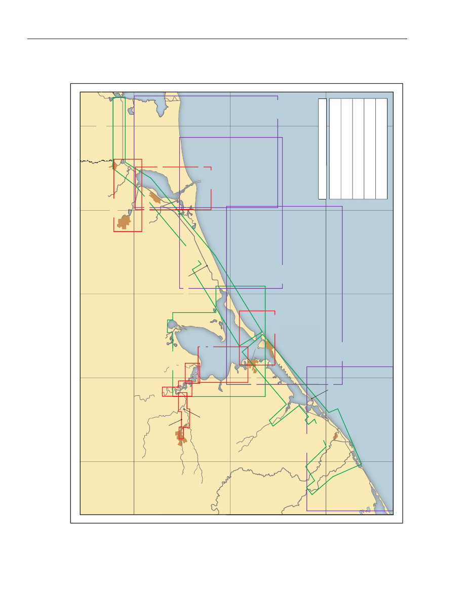
Sabine Pass to San Luis Pass
(1)
This chapter describes the 77-mile-long Texas Gulf
Coast from Sabine Pass to San Luis Pass, and Port Ar-
thur Canal, Sabine-Neches Canal, Neches River,
Galveston Bay, East and West Bays, Houston Ship
Channel and their tributary waterways. Also discussed
are the deepwater ports of Port Arthur, Beaumont, Or-
ange, Galveston, Texas City, and Houston.
COLREGS Demarcation Lines
(2)
The lines established for this part of the coast are
described in 80.840 and 80.845, chapter 2.
Weather
(3)
The climate of this coast ranges from warm and hu-
mid in summer to moderately subtropical in winter.
During the warmer months, warm humid air from the
Gulf brings showers and thunderstorms and an occa-
sional tropical cyclone. There are periods of modified
continental influence during the colder months when
extratropical systems to N occasionally penetrate the
Gulf region of Texas. These systems and their fronts
produce low temperatures and “northers”, strong, cold
winds from N. Cold fronts reaching this area are sel-
dom severe. Temperatures drop to freezing or below
only four times a year in Galveston, on average. Spring
days are typically mild, with brisk winds and frequent
showers. Early autumn is essentially an extension of
summer. November brings an increase in N winds and
cold spells.
(4)
Navigational hazards in winter include strong
winds, rough seas, and poor visibilities. Winds from
extratropical cyclones and their associated fronts are
often “northers” and reach 40 knots or more. Gales
(winds of 34 knots or more) blow about 1 percent of the
time from November through March. These winds usu-
ally pose little problem to vessels lying close to the Gulf
coastline, as they blow offshore. Seaward, with an in-
creasing fetch, waves become higher. Wave heights of
12 feet or more are encountered 1 to 2 percent of the
time, and waves greater than 20 feet have been re-
ported. On average, a 32-foot significant wave height
from December through April can be expected every 10
years. Visibilities drop below 2 miles 2 to 3 percent of
the time during this period. Precipitation also restricts
visibilities.
(5)
The tropical cyclone season extends from late May
into early November. There is about a 30 percent
chance of a tropical cyclone (tropical storm and hurri-
cane) and a 20 percent chance of a hurricane along this
coast in any given year. The 1900 hurricane completely
destroyed the city of Galveston, but the building of a
17-foot seawall on the Gulf side of the island has re-
duced the danger of sea and swell action. Tropical cy-
clones are dangerous to shipping near the coast,
because the winds often blow onshore. Based on statis-
tics, it is estimated that every 10 years, on average, sus-
tained winds will reach 85 knots while maximum
significant wave heights build to 32 feet.
Charts 11330, 11340
(6)
Sabine Pass and its connecting channels form an
extensive system of deepwater routes leading inland as
far as Beaumont and Orange, Texas. From Sabine Pass
the coast follows a general WSW direction for 50 miles
to Galveston Entrance. Except in the E part, deep water
extends fairly close inshore. The coast is low and devoid
of prominent features, with the exception of High Is-
land. Heald Bank, off the coast, has depths of 25 to 35
feet and is a danger to deep-draft vessels.
(7)
Galveston Entrance is the approach to the cities of
Galveston, Texas City, and Houston. Galveston Bay and
tributaries form one of the larger commercial ports in
the United States, and have extensive foreign and coast-
wise trade.
Shipping Safety Fairways and Fairway Anchorages
(8)
A system of shipping safety fairways has been estab-
lished along the Gulf Coast to provide safe lanes for
shipping that are free of oil well structures. Vessels ap-
proaching the passes and entrances to ports, or bound
along the Gulf Coast between Sabine Pass and San Luis
Pass should proceed in the charted shipping safety fair-
ways. Caution should be exercised when approaching
or navigating in these fairways as they are unmarked.
(9)
Fairway anchorages have been established off the
entrances to the ports, which will be generally free of
oil well structures. (See 166.100 through 166.200,
chapter 2, for regulations governing the fairways and
anchorages.)
Sabine Pass to San Luis Pass
■
Chapter 10
■
425

Charts 11342, 11341, 11330
(10)
Sabine Pass, 244 miles W of Southwest Pass, Mis-
sissippi River, and 50 miles ENE of Galveston Entrance,
is the approach from the Gulf to Sabine Lake, Sabine
and Neches Rivers, and the cities of Port Arthur, Beau-
mont, and Orange.
(11)
Sabine Pass, Lake, and River together form the
boundary between the States of Louisiana and Texas for
a distance of 275 miles N from the Gulf.
Prominent features
(12)
The most prominent objects seen when approach-
ing Sabine Pass are the E jetty light, an abandoned
lighthouse, a white 81-foot tower on the E side of the
pass, and the dredging range towers. Also prominent
are the entrance range lights, the oil and water tanks W
of Sabine Pass, and a stack at Port Arthur.
(13)
Sabine Pass East Jetty Light (29°38'41"N.,
93°49'22"W.), 42 feet above water, is shown from a cy-
lindrical steel tower on piles at the S end of the jetty.
(14)
Sabine Coast Guard Station is on the W side of the
pass, about 5.8 miles above the E jetty light.
(15)
Vessels should approach Sabine Pass through the
prescribed Safety Fairway. (See 166.100 through
166.200, chapter 2.)
COLREGS Demarcation Lines
(16)
The lines established for Sabine Pass are described
in 80.840, chapter 2.
Channels
(17)
The entrance, obstructed by a bar, has been im-
proved by the construction of two nearly parallel jetties
about 550 yards apart extending about 3.5 miles in a S
direction from shore. The general depths between jet-
ties, outside the channel, are 8 to 16 feet. Numerous
charted and uncharted hazards exist in the vicinity of
the outer bar channel; caution is advised. Federal pro-
ject depths are 42 feet in the outer bar channel, thence
40 feet through the jetty channel to and through Port
Arthur Canal, with 40 feet in the E and W turning bas-
ins and Taylor Bayou turning basin at Port Arthur. (See
Notice to Mariners and latest editions of charts for con-
trolling depths.)
(18)
The bar channel is marked by a 337°18' lighted
range and lighted buoys, and the channel through the
jetties by a 347° lighted range and lighted and
unlighted buoys. Unlighted dredging ranges, main-
tained by the Corps of Engineers, mark the sides of the
outer bar and jetty channels.
(19)
Inside the jetties, the pass extends NW about 6
miles to Sabine Lake. The bottom outside the channel
for the most part is soft, and vessels can touch without
damage. Lighted ranges and other lighted aids mark
the channel through Sabine Pass and Port Arthur Ca-
nal to Port Arthur.
Sabine-Neches Waterway Navigation Guidelines
(20)
The Sabine Pilots provide a coordination service to
traffic in Sabine Bank Channel, Sabine Pass, Port Ar-
thur Canal, Sabine-Neches Canal, and Neches River.
They have adopted the following procedures regarding
meeting situations as discussed below. The procedures
are not Coast Guard regulations, but are guidelines
that the Sabine Pilots have established and use to en-
sure that vessels meet safely.
(21)
(1) Vessels with a combined beam that equals or ex-
ceeds one-half the channel width will not meet, day or
night.
(22)
(2)
Above
the
Texaco
Island
intersection
(29°49.5'N., 93°57.5'W.), vessels 85,000 deadweight
tons or more will not meet vessels of either 30,000
deadweight tons or greater, or vessels with drafts of 25
feet or greater.
(23)
(3) Above Buoys 29 and 30, vessels of 85,000 dead-
weight tons or greater will not meet any vessel of
30,000 deadweight tons or more with a draft of 30 feet
or greater.
(24)
(4) Vessels of 48,000 deadweight tons or more with
a draft of 30 feet or greater will not meet above Buoys
29 and 30.
(25)
(5) Vessels with a combined draft of 65 feet or more
will not meet in the Neches River at night.
(26)
(6) The Fina turning basin (29°59.2'N., 93°54.4'W.)
and Sun Oil turning basin (30°00.6'N., 93°59.0'W.) are
not used for anchorages, but for meeting situations in
which the size of the two vessels or other surrounding
circumstances preclude their meeting in the channel.
The inbound or outbound vessel, as appropriate,
should vacate turning basins as soon as possible.
(27)
(7) The project depth of the Sabine-Neches Water-
way is 40 feet. This depth coupled with tidal fluctua-
tions and weather conditions will govern policy on
maximum draft limitations. Meeting situations in
channel bends should be avoided whenever possible.
(28)
The Sabine Pilots request that vessels transiting
the waterway check in with the Sabine Pilots Dis-
patcher on VHF-FM channel 20 at the following loca-
tions:
(29)
(1) Sabine Bank Channel Lighted Gong Buoy 29
and Lighted Buoy 30 (29°36'N., 93°48'W.).
(30)
(2) Port Arthur Canal Light 40 (Mesquite Point).
(31)
(3) Port Arthur turning basin, Taylor Bayou.
(32)
(4) Sabine-Neches Canal Light 65 (Neches River
Intersection).
(33)
(5) Neches River Light 40 (McFadden Bend Cutoff).
426
■ Chapter 10
■
Volume 5

(34)
Nothing in these coordination guidelines should
be construed as limiting a pilot in his good judgment.
(35)
A regulated navigation area has been established in
Sabine Neches Waterway (Sabine Pass Channel, Port
Arthur Canal, Sabine-Neches Canal, Neches River,
Sabine River and all navigable waterways tributary
thereto). (See 165.1 through 165.13 and 165.806,
chapter 2, for limits and regulations.)
Anchorages
(36)
Deep-draft vessels usually anchor in the Sabine
Fairway Anchorages outside of the pass entrance. (See
166.100 through 166.200, chapter 2.) Vessels of light
draft can find good holding ground 7 to 8 miles W of the
jetties as close inshore as drafts will permit. The pass
affords excellent anchorage for small craft, and is used
by coasting vessels as a wintertime harbor of refuge.
(37)
An anchorage basin, Federal project depth 40 feet,
is on the E side of Sabine Pass Channel opposite the
town of Sabine Pass. (See 110.1 and 110.196, chapter
2, for limits and regulations, and Notice to Mariners
and latest editions of charts for controlling depths.)
The portion of the pass off the town of Sabine Pass and
SW of the ship channel is used as an anchorage by small
light-draft vessels and was reported dredged to 21 feet
in 1982.
Dangers
(38)
The offshore oil well structures, Sabine Bank, and
the spoil and dumping grounds on either side of the en-
trance channel are the principal dangers encountered
when approaching Sabine Pass. Vessels should not ap-
proach the entrance too closely before the pilot boards.
(39)
A strong westerly current known to cause
groundings after tropical cylcones was reported be-
tween Sabine Bank Channel Lighted Buoys 17 and 18,
and between Sabine Bank Lighted Buoy 33 and Lighted
Bell Buoy 34; extreme caution is advised.
Security Zones
(40)
The Captain of the Port, Port Arthur has estab-
lished a security zone in Sabine Bank Channel, Sabine
Pass Channel and Sabine-Neches Waterway. (See
165.30 through 165.33 and 165.819, chapter 2, for
limits and regulations.)
Currents
(41)
The currents off the entrance of Sabine Pass are de-
pendent upon the direction and velocity of the wind.
Following continued N to E winds, a SW to W current
will be found off the entrance, frequently with a veloc-
ity of 1 knot and sometimes as much as 2 knots. Follow-
ing S and SW winds, the currents will be in the opposite
direction, but with less velocity. The tidal current
between the jetties at strength averages 1.1 knots on
the flood and 1.6 knots on the ebb, but velocities up to
2.5 knots have been observed in Sabine Pass. Tidal cur-
rent predictions for Sabine Pass may be found in the
Tidal Current Tables, Atlantic Coast.
Weather
(42)
Port Arthur’s climate is a mixture of tropical and
temperate zone conditions. Sea breezes help prevent
extremely high summer temperatures, except on rare
occasions, and the area lies far enough S so that cold air
usually moderates before reaching the area. Summer
temperatures climb to 90°F or more on about 84 days
each season while winter readings fall to 32°F and be-
low on about 14 days annually. The average annual
temperature of Port Arthur is 68.9°F. The average an-
nual maximum is 78.1°F while the average minimum
is 59.1°F. The warmest month is July with an average
temperature of 83.1°F while the coolest month is Janu-
ary with an average temperature of 52.2°F. The warm-
est temperature on record is 107°F recorded in August
1962 while the coolest temperature on record is 12°F
recorded in December 1989. Each month, June
through September has recorded temperatures at or
above 100°F while each month, October through April,
has recorded temperatures at or below freezing.
(43)
Rain occurs year round, with minimums usually in
March and April. The average annual rainfall for Port
Arthur is 56.75 inches. September is the wettest month
averaging 5.67 inches and March is the driest averaging
3.26 inches. The greatest 24-hour rainfall occurred in
September 1963 when 12.09 inches accumulated. Win-
ter precipitation is often steady, while in summer,
showers and thunderstorms are more likely. Snow and
sleet are infrequent; the greatest snowfall in a single
storm was 3.5 inches in February 1960. Thunderstorms
are most likely in July and August, when they are ob-
served on 13 to 14 days per month, on average. They are
most violent in spring and can produce strong, gusty
winds. The annual average number of thunderstorms is
69.
(44)
Tropical cyclones are most likely in September, al-
though the season runs from late May into early No-
vember. During Audrey, in June 1957, the Coast Guard
station at Sabine Pass recorded sustained winds to 85
mph with gusts to 100 mph. Storm tides reached 9 feet
above mean sea level. Carla, in September 1961, gener-
ated 5- to 9-foot tides in the Port Arthur area.
(45)
Fog is most frequent in midwinter and rare in sum-
mer. It usually dissipates before noon, but occasionally,
under stagnant conditions, it lasts into the afternoon.
Along the coast, it may not develop until daybreak, but
inland, where radiation is more effective, it may form
before midnight. At Sabine Pass, the sound signals
Sabine Pass to San Luis Pass
■
Chapter 10
■
427

operate an average of 90 to 120 hours per month from
December through March. At Port Arthur, visibilities
drop to 0.25 mile or below on 6 to 8 days per month
during this period. (See Appendix B for Port Arthur cli-
matological table.)
(46)
The National Weather Service maintains an office
in Port Arthur; barometers may be compared there or
by telephone. (See Appendix A for address.)
Pilotage, Port Arthur
(47)
Pilotage is compulsory for all foreign vessels and
U.S. vessels under register in the foreign trade. Pilotage
is optional for coastwise vessels that have on board a pi-
lot licensed by the Federal Government. The Sabine Pi-
lots have an office in Groves, Texas, and a pilot station
at Sabine, Texas, at the inner end of the W jetty at
Sabine Pass.
(48)
The three pilot boats, SABINE PILOT and SABINE
PILOT II, each 65 feet long, and SABINE BANK PILOT,
45 feet long, each have a black hull and a white house
with green trim. The International Code flag “P” is
flown. The boats are equipped with a radiotelephone
and monitor VHF-FM channels 13, 14, 16, and 20 and
use channel 14 as a working channel. The pilot office at
Groves monitors VHF-FM channel 20. All the pilots
carry portable radiotelephones. The pilot boats meet
vessels, day or night, at the sea buoy or at Sabine Bank
Channel Lighted Gong Buoy 29, according to the pref-
erence of the vessel. For boarding, the pilots request
that the pilot ladder is rigged 8 feet above the water. Pi-
lots can be obtained on a minimum of 4 hours advance
notice which should include the vessel’s length, beam,
DWT, freshwater deep draft, berth assignment, and
ETA. Notice may be given by telephone 409-722-1141,
962-8580, 962-8589 through the Port Arthur Marine
Operator, by FAX 409-962-9223, or through ships’
agents.
(49)
The Coast Guard Captain of the Port highly recom-
mends all tank vessels with drafts greater than 27 feet
to secure pilotage services throughout the length of
Sabine Bank Channel, especially during periods of re-
stricted visibility. It is recommended that vessels em-
bark and disembark pilots at Sabine Bank Channel
Lighted Whistle Buoy SB.
Towage
(50)
Vessels usually proceed without assistance through
the pass to Port Arthur. Radiotelephone equipped tugs
up to 3,900 hp are available at Port Arthur. The tug
companies are equipped to perform wrecking and sal-
vage operations.
Quarantine, customs, immigration, and agricultural
quarantine
(51)
(See chapter 3, Vessel Arrival Inspections, and Ap-
pendix A for addresses.)
(52)
Quarantine is enforced in accordance with regula-
tions of the U.S. Public Health Service. (See Public
Health Service, chapter 1.) The city has three hospitals.
(53)
Port Arthur is a customs port of entry.
Coast Guard
(54)
A marine safety unit is in Port Arthur. (See Appen-
dix A for address.)
(55)
Texas Bayou, on the W side opposite the aban-
doned Sabine Pass lighthouse, has facilities for small
craft to dock and a launching ramp. Water, ice, and
some provisions are available from a nearby store. Gas-
oline is available at a dock about 0.5 mile SSE of the
bayou’s entrance on Sabine Pass.
(56)
Sabine is a village on the W side of the pass, about 5
miles above the outer end of the jetties. The S of the two
old slips is used as a small-boat harbor where gasoline,
diesel fuel, water, and ice are available. There is a men-
haden plant and wharf, and many shrimp boats base
here. Several oil companies have bases for supplying
offshore oil wells.
(57)
Sabine is a customs port of entry.
(58)
Sabine Pass is a village on the W side of the pass
about 1.5 miles N of Sabine. Shrimp boats base here.
(59)
Sabine Lake has an average depth of about 6 feet in
its 15-mile length. At the S end, where it empties into
Sabine Pass, the depth is 1 to 4 feet. A fixed highway
bridge over the S end has a clearance of 65 feet. An
overhead power cable close NW of the bridge has a
clearance of 75 feet. Numerous gas and oil well struc-
tures, pipes, piles, stakes, and wrecks, some sub-
merged, exist within Sabine Lake. In addition to the S
entrance from Sabine Pass, the lake can be entered also
from the Sabine-Neches Canal or through Sabine
River. The depth through East Pass is about 3 feet.
(60)
A 1.5-mile-long bulkhead is off the Port Arthur wa-
terfront on the W side of Sabine Lake. A channel with a
reported controlling depth of about 4 feet leads
through a narrow opening in the bulkhead to a marina
basin. Berths, gasoline, diesel fuel, water, ice, marine
supplies, and a launching ramp are available.
(61)
Johnson Bayou, in the extreme SW part of Louisi-
ana, empties into the SE part of Sabine Lake, directly E
of Port Arthur. The dredged channel leading to the en-
trance has filled to the lake bottom level. In 1987, the
reported depth was 3 feet into the mouth of the bayou.
The entrance is marked by private stakes and buoys. In-
side the entrance, the bayou is deeper and navigable for
about 4.5 miles to the settlement of Johnson Bayou; a
428
■ Chapter 10
■
Volume 5

highway connects the settlement with Sulphur. A
channel, marked by a private light and buoys, leads
NNW across Sabine Lake from Johnson Bayou to the
Sabine-Neches Canal.
(62)
Port Arthur Ship Canal extends for about 6 miles
from Sabine Pass to the entrance to Taylor Bayou. A
narrow strip of land separates the canal from the W
shore of Sabine Lake. Lights and lighted ranges mark
the channel to Taylor Bayou.
(63)
Port Arthur, an important shipping center, is on
the W shore of the Sabine Lake, 17 miles above the
Sabine Pass entrance. There are several large oil refin-
eries and chemical plants, two shipyards, a grain eleva-
tor, and numerous small industrial firms at Port
Arthur.
(64)
The principal industrial development is on Taylor
Bayou, at the SW outskirts of the city, sometimes
known as West Port Arthur. The port has extensive do-
mestic and foreign trade in chemicals and crude petro-
leum and its refined products. There is some
commerce in grain, lumber, iron and steel products,
cotton, scrap iron, glass and clay products, shell, paper
products, alcohol, caustic soda, menhaden, vegetable
and fish oils, lead, and general merchandise.
Harbor regulations
(65)
The port is under the control of the Port of Port Ar-
thur Navigation District. A Port Commission, under a
Port Director, is responsible for the development and
operation of the port and establishes regulations.
Wharves
(66)
Port Arthur has more than 90 wharves and piers.
Only the deep-draft facilities are described. For a com-
plete description of the port facilities refer to Port Se-
ries No. 22, published and sold by the U.S. Army Corps
of Engineers. (See Appendix A for address.) The along-
side depths are reported; for information on the latest
depths contact the private operator. All of the facilities
have direct highway and railroad connections. Water
and electrical shore power connections are available at
most piers and wharves. General cargo at the port is
usually handled by ship’s tackle; special handling
equipment, if available, is mentioned in the description
of the particular facility. Cranes up to 150 tons are
available at Port Arthur. Floating cranes with capacities
up to 125 tons are also available.
(67)
Plains
Marketing,
Sabine
Pass
Wharf
(29°44'21"N., 93°53'19"W.): 40-foot face; 300 feet of
berthing space with dolphins; 27 feet alongside; deck
height, 6 feet; receipt and shipment of crude oil; owned
and operated by Plains Marketing.
(68)
Premcor Refining Group, Port Arthur Refinery,
Tug Mooring Wharf (29°51'05"N., 93°58'18"W.):
300-foot face; 300 feet of berthing space; 17 feet along-
side; deck height, 7 feet; pipeline to wharf for shipping
liquid sulphur (2001 operation scheduled); occasional
mooring of tugboats; owned and operated by Premcor
Refining Group, Inc., Subsidiary of Premcor, Inc.
(69)
Premcor Refining Group, Port Arthur Refinery,
Berths Nos. 0 to 6 (29°50'47"N., 93°58'07"W.):
1,200-foot face (middle portion); 1,200 feet of berthing
space; 40 feet alongside; deck height, 7 feet; receipt and
shipment of crude oil, petrochemicals; and petroleum
products; receipt of liquid caustic soda; shipment of
spent liquid caustic soda; occasional loading of barges
for bunkering vessels; owned and operated by Premcor
Refining Group, Inc., Subsidiary of Premcor, Inc.
(70)
Great Lakes Carbon Corp. Wharf (29°50'03"N.,
93°57'51"W.): 680-foot face; 980 feet of berthing space
with dolphins; 40 feet alongside; deck height, 8 feet;
one electric loading tower with 90-foot boom with
spout, maximum loading rate 600 tons per hour,
belt-conveyor system; shipment of calcined petroleum
coke; owned by Rice Carden Corp., and operated by
Great Lakes Carbon Corp.
(71)
United Marine Enterprise, Port Arthur Shipyard,
Motiva
Enterprises
No.
3
Dock
(29°50'23"N.,
93°57'20"W.): 1,400-foot face; 1,400 feet of berthing
space; 28 to 30 feet alongside; deck height, 12 feet; 4.8
acres open storage; mooring vessels and offshore drill-
ing rigs for repair; mooring government-owned vessels
for maintenance; owned by Motiva Enterprises, LLC.,
and operated by United Marine Enterprise, Inc.
(72)
Motiva Enterprises, Port Arthur Terminal, No. 1
Dock Wharf, Berths Nos. 6 and 7 (29°49'59"N.,
93°57'25"W.): 1,140-foot face; 1,500 feet of berthing
space; 37 feet alongside; deck height, 10 feet; receipt of
methyl tertiary butyl ether and ballast water; shipment
of petroleum products and cyclohexane; occasional
loading of barges for bunkering vessels at berth; owned
and operated by Motiva Enterprises, LLC.
(73)
Motiva Enterprises, Port Arthur Terminal, No. 2
Dock Wharf, Berths Nos. 1 and 2 (29°49'43"N.,
93°57'36"W.): 280-foot face (No.1); 700 feet of berthing
space with dolphins (No.1); deck height, 9.2 feet;
830-foot face (No.2); 1,100 feet of berthing space
(No.2); 37 feet alongside; receipt of ballast water; ship-
ment of petroleum products; occasional loading of
barges for bunkering vessels at berth; and mooring of
barges; mooring vessels for transfer of plant equipment
to barges; owned and operated by Motiva Enterprises,
LLC.
(74)
Port of Port Arthur, Public Ocean Terminal, Upper
Wharf, Berths Nos. 1 and 2 (29°51'45"N., 93°56'12"W.):
Sabine Pass to San Luis Pass
■
Chapter 10
■
429

1,380-foot face; 1,380 feet of berthing space; 40 feet
alongside; deck height, 15 feet; receipt and shipment of
conventional, containerized, and roll-on/roll-off gen-
eral cargo in foreign and domestic trade; owned and op-
erated by Port of Port Arthur Navigation District of
Jefferson County, Texas.
(75)
Port of Port Arthur, Public Ocean Terminal,
Lower Wharf, Berths Nos. 3 to 5 (29°51'32"N.,
93°56'25"W.): 1,720-foot face; 1,820 feet of berthing
space; 40 feet alongside; deck height, 15 feet; one trav-
eling gantry crane with 75-ton capacity; 15.3 acres
open storage; receipt and shipment of conventional,
containerized, and roll-on/roll-off general cargo in for-
eign and domestic trade; owned and operated by Port of
Port Arthur Navigation District of Jefferson County,
Texas.
(76)
Atlantic Shippers of Texas Wharf (29°55'35"N.,
93°52'44"W.): 730-foot face; 700 feet of berthing space;
28 feet alongside; deck height, 12 feet; conveyor system
and 80-ton crane, loading rate, 200 tons per hour; re-
ceipt and shipment of ingredients for livestock feed; oc-
casional mooring of vessels; owned and operated by
Atlantic Shippers of Texas, Inc., Subsidiary of Animal feeds
International Corp.
(77)
Global Terminaling Services Wharf (29°55'49"N.,
93°52'31"W.): 755-foot face; 800 feet of berthing space;
40 feet alongside; deck height, 15.7 feet; one traveling
tower with hinged boom and conveyor, loading rate,
3,000 tons per hour; shipment of petroleum coke; occa-
sional mooring of vessels; owned by Kansas City South-
ern Industries, and operated by Global Terminaling
Services, Inc.
Supplies
(78)
Provisions and marine supplies can be obtained in
Port Arthur. Water of good quality is available alongside
the wharves or can be delivered in barges. Bunker fuels
can be obtained from Premcor Refining Group, Port
Arthur Refinery, Berths Nos. 0 to 6, or elsewhere in the
harbor by barge. Small boats can obtain gasoline, oil,
water, and supplies along the city waterfront of the
Sabine-Neches Canal.
Repairs
(79)
Port Arthur has two shipyards on the W side of the
Sabine-Neches Canal. The yard about 2.5 miles above
Taylor Bayou builds drilling rigs, has three floating
drydocks with a maximum capacity of 4,200 tons, and
can handle vessels up to 350 feet. The second yard,
about 7 miles above Taylor Bayou, has a 3,000-ton float-
ing drydock and two marine railways; vessels up to 125
feet can be handled. Both yards have machine, electri-
cal welding, and carpenter shops, and make general
repairs. Floating cranes up to 125 tons are available in
the port.
Communications
(80)
Radio station WPA provides ship-to-shore radio-
telephone service. The port is served by the Kansas City
Southern and Southern Pacific Railroads, buslines, and
an airline. The Jefferson County Airport is NW of the
city.
(81)
Taylor Bayou, 6 miles above Sabine Pass, is the site
of many of the deep-draft facilities at Port Arthur. Fed-
eral project depth for the basins and connecting chan-
nels in the bayou is 40 feet. (See Notices to Mariners
and latest editions of the charts for controlling depths.)
Barriers, 1.6 miles and 2.3 miles above the entrance,
obstruct through navigation on Taylor Bayou. The up-
per reach of Taylor Bayou, navigable for about 29 miles,
is accessible through Taylor Bayou Outfall Canal,
which is entered from the Intracoastal Waterway at
Mile 290.3W. Taylor Bayou Outfall Canal and the upper
reach of Taylor Bayou are discussed in chapter 12.
(82)
The Sabine-Neches Canal is a continuation of the
Port Arthur Ship Canal above the mouth of Taylor
Bayou. It extends parallel with the shores of Sabine
Lake, from which it is separated by a narrow strip of
land, NE to the mouth of Neches River, thence E
through the open water of the N part of Sabine Lake to
the mouth of Sabine River. The Federal project depths
are 40 feet to the mouth of Neches River, thence 30 feet
to the mouth of Sabine River. (See Notice to Mariners
and latest editions of charts for controlling depths.)
Lights, lighted ranges, and buoys mark the channel.
(83)
A fixed highway bridge with a clearance of 136 feet
crosses the Sabine-Neches Canal at Port Arthur 1.8
miles above the entrance to Taylor Bayou.
(84)
During high-river stages on Neches River, usually
from January to the last of April, a vessel may encoun-
ter an athwartship current crossing Neches River along
the canal route, which may prove dangerous if not
guarded against.
Chart 11343
(85)
Neches River empties into Sabine Lake from the
NW and extends in a ship canal 18.5 miles to Beau-
mont. A Federal project provides for a 40-foot channel
to a 34-foot turning basin at Beaumont, thence 30 feet
to the Bethlehem Shipyards. (See Notice to Mariners
and latest editions of charts for controlling depths.)
Lights, lighted ranges, and buoys mark the river.
(86)
State Route 87 highway bridge (Rainbow Bridge)
over the river, about 1.5 miles above its mouth, has a
fixed twin span with a clearance of 143 feet. This twin
430
■ Chapter 10
■
Volume 5

bridge and the one at Port Arthur are the only bridges
crossing the channel between the Gulf and the turning
basin at Beaumont. Overhead power cables with clear-
ances of 164 feet cross the river 50 yards E of State
Route 87 highway bridge and just E of McFadden Bend
Cutoff. These are the least overhead cable clearances
between Port Arthur and the turning basin at Beau-
mont.
(87)
On the W side, at the turn from the Sabine-Neches
Canal into the Neches River, there are several basins in
which are a marine service wharf, a small-vessel fuel-
ing wharf, and a boat club. The marine service wharf re-
pairs small vessels and barges and operates a tank
cleaning service.
(88)
A marina is on the long canal just W of the S end of
State Route 87 highway bridge. Gasoline and berths are
available. In 1982, reported depths of about 5 feet could
be carried to the marina.
(89)
Port Neches, on the Neches River 5 miles above the
mouth, is an important oil refining and chemical cen-
ter. Petroleum products, asphalt, and roofing material
are exported. Port Neches has several private oil han-
dling terminals, a layup berth maintained by a ship re-
pair firm that does above-the-waterline hull and engine
repairs, and a wharf and ramp at which gasoline and
water are available. The private oil handling terminals
are discussed later in this chapter under Wharves,
Beaumont.
(90)
The marsh island N of McFadden Bend Cutoff has
been dredged away except for a strip 300 feet wide. The
dredged area forms an anchorage for decommissioned
ships under jurisdiction of the U.S. Maritime Adminis-
tration and has a controlling depth of 18 feet. (See
162.270, chapter 2, for regulations restricting naviga-
tion in the vicinity.)
(91)
Above Beaumont, a depth of about 10 feet can be
carried for about 12 miles upriver, but there is no com-
merce in this section and probably many snags ob-
struct the channel.
(92)
Beaumont, on Neches River 18.5 miles above
Sabine Lake and 43 miles from the Gulf, is the largest
city in E Texas, and the home of Lamar University. Pe-
troleum, petrochemical, and shipbuilding and repair
are the principal industries. Commerce is principally in
petroleum products, chemicals, molasses, wheat, flour,
rice, synthetic rubber, shell, paper pulp, cement, dry
and liquid sulfur, iron and steel products, scrap iron,
and lumber and wood products.
Anchorages
(93)
There are no anchorages at Beaumont and only
emergency anchorage is permitted in Neches River.
Vessels may tie up to the banks of the river for a limited
period provided permission is obtained from the Corps
of Engineers. There is temporary anchorage in 29 feet
in the bends of the old river below Port Neches and W of
the cutoff about a mile above McFadden Bend Cutoff.
There is little swinging room.
(94)
A barge assembly basin, 2,200 feet long and 350 feet
wide for the temporary mooring of barges of tows, is in
the bend of the former channel close N of Deer Bayou.
Moorings spaced about 175 feet apart on concrete
deadmen are on the NE side of the basin.
(95)
The channel is clear, and all bends of less than
5,000-foot radius have been eliminated by cutoffs be-
tween the mouth of Neches River and Beaumont; there
are a few places where a vessel may turn around.
(96)
Two bridges cross the improved channel above the
turning basin at Beaumont. The first, the Kansas City
Southern vertical lift railroad bridge, about 0.4 mile
above the turning basin, has a clearance of 13 feet down
and 147 feet up. (See 117.1 through 117.49, chapter 2,
for drawbridge regulations.) The second, Interstate
10-U.S. 90 highway bridge, about 1 mile above the rail-
road bridge, has a fixed span with a clearance of 48 feet.
Pilotage, Beaumont
(97)
See Pilotage, Port Arthur (indexed as such) early
this chapter.
Towage
(98)
Tugs to 3,950 hp are available at Beaumont.
Quarantine, customs, immigration, and agricultural
quarantine
(99)
(See chapter 3, Vessel Arrival Inspections, and Ap-
pendix A for addresses.)
(100)
Quarantine is enforced in accordance with regula-
tions of the U.S. Public Health Service. (See Public
Health Service, chapter 1.) Beaumont has several pub-
lic and private hospitals, and several clinics and infir-
maries.
(101)
Beaumont is a customs port of entry.
Harbor regulations
(102)
The Board of Commissioners of the Port of Beau-
mont Navigation District, known as the Port Authority,
has jurisdiction over and controls all terminals,
wharves, sheds, warehouses, and equipment owned
and operated by it. The Port Authority establishes
rules, regulations, and tariffs governing the port. The
Port Director is in charge of operations; the Superin-
tendent of Docks assigns berths.
Wharves
(103)
Beaumont has more than 70 wharves and piers.
Only the deep-draft facilities are described. For a com-
plete description of the port facilities refer to Port
Sabine Pass to San Luis Pass
■
Chapter 10
■
431

Series No. 22, published and sold by the U.S. Army
Corps of Engineers. (See Appendix A for address.) The
alongside depths are reported; for information on the
latest depths contact the private operator. The port’s
waterfront facilities extend along the S bank of the
Neches River for about 19 miles. Most of the facilities
have direct highway and railroad connections, and
most of the piers and wharves have water and electrical
shore power connections. General cargo at the port is
usually handled by ship’s tackle; special handling
equipment, if any, is mentioned in the description of
the particular facility. Cranes up to 220 tons and a
500-ton floating derrick are available at Beaumont.
(104)
S side Neches River:
(105)
Fina Oil and Chemical Co., Port Arthur Terminal,
No.1 Dock (29°58'49"N., 93°52'40"W.): 512-foot face;
900 feet of berthing space with dolphins; 40 feet along-
side; deck height, 14 feet; receipt of crude oil and
xylene; receipt and shipment of naptha; shipment of pe-
troleum products; owned and operated by Fina Oil and
Chemical Co., Inc., a subsidiary of TotalFinaElf SA.
(106)
Fina Oil and Chemical Co., Port Arthur Terminal,
No.1 Dock A (29°58'50"N., 93°52'48"W.): 223-foot face;
550 feet of berthing space with dolphins; 35 feet along-
side; deck height, 12.5 feet; receipt and shipment of
benzene, toluene, and petroleum products; owned and
operated by Fina Oil and Chemical Co., Inc., a subsid-
iary of TotalFinaElf SA.
(107)
Fina Oil and Chemical Co., Port Arthur Terminal,
Dock B (29°58'50"N., 93°52'54"W.): 237-foot face; 500
feet of berthing space with dolphins; 30 feet alongside;
deck height, 12.5 feet; receipt of asphaltene and xylene;
receipt and shipment of benzene, toluene, and petro-
leum products; owned and operated by Fina Oil and
Chemical Co., Inc., a subsidiary of TotalFinaElf SA.
(108)
Port Neches:
(109)
Huntsman Corp., Oxides and Olefins (O&O) Fa-
cility, Port Neches No.1 Dock Wharf (29°59'22"N.,
93°55'46"W.): 160-foot face; 800 feet of berthing space
with dolphins; 38 feet alongside; deck height, 9 feet;
shipment and occasional receipt of petrochemicals; re-
ceipt of liquid caustic soda; owned and operated by
Huntsman Corp.
(110)
Motiva Enterprises, Port Neches Terminal, No. 3
Dock Wharf (29°59'26"N., 93°56'03"W.): 60-foot face;
600 feet of berthing space with dolphins; 28 feet along-
side; deck height, 8.5 feet; receipt of crude oil, naptha,
and gas oil; shipment of pyrolysis gasoline by barge;
owned by Motiva Enterprises, LLC and Huntsman
Corp., and operated by Motiva Enterprises, LLC.
(111)
Motiva Enterprises, Port Neches Terminal, No. 2
Dock Wharf (29°59'30"N., 93°56'13"W.): 205-foot face;
950 feet of berthing space with dolphins; 40 feet along-
side; deck height, 8.5 feet; receipt of crude oil, naptha,
petroleum products, and occasionally gas oil; owned by
Motiva Enterprises, LLC and Huntsman Corp; and op-
erated by Motiva Enterprises, LLC.
(112)
Motiva Enterprises, Port Neches Terminal, No. 1
Dock Wharf (29°59'34"N., 93°56'23"W.): 192-foot face;
800 feet of berthing space with platforms; 40 feet along-
side; deck height, 8.5 feet; receipt of crude oil and
methanol; receipt and shipment of petroleum prod-
ucts; owned by Motiva Enterprises, LLC and Huntsman
Corp.; and operated by Motiva Enterprises, LLC.
(113)
Huntsman Petrochemical Corp., C4 Facility, Port
Neches No. 2 Dock Wharf (29°59'37"N., 93°56'33"W.):
81-foot face; 500 feet of berthing space with dolphins;
27 to 30 feet alongside; deck height, 11 feet; receipt of
crude butadiene, methanol, and styrene; occasional
shipment of butadiene and other liquified petroleum
gases; owned by Ameripol Synpol Co. and Huntsman
Corp.; and operated by Huntsman Petrochemical Corp.
(114)
Huntsman Petrochemical Corp., C4 Facility, Port
Neches No. 3 Dock Wharf (29°59'39"N., 93°56'38"W.):
40-foot face; 310 feet of berthing space with dolphins;
24 feet alongside; deck height, 14 feet; receipt of crude
butadiene, methanol, and styrene; occasional shipment
of butadiene and other liquified petroleum gases; all by
barge; owned by Ameripol Synpol Co. and Huntsman
Corp.; and operated by Huntsman Petrochemical Corp.
(115)
Union Oil Co. Of California, Beaumont Terminal,
Main Dock, Berths 1 to 5, and 7 (30°00'31"N.,
93°58'26"W.): 1,170-foot face; 1,170 feet of berthing
space; 40 feet alongside; deck heights, 14.5 feet (top
deck) and 4.5 feet (lower deck); receipt and shipment of
crude oil, petroleum products, and petrochemicals; re-
ceipt of ballast water; receipt of bunker fuel and other
products by barge for bunkering and loading tankers
berthed at wharf; owned and operated by Union Oil Co.
of California.
(116)
Sun Marine Terminals, Ship Dock No. 1
(30°00'27"N., 93°58'58"W.): 93-foot face; 875 feet of
berthing space with dolphins; 40 feet alongside; deck
height, 18 feet; receipt and shipment of crude oil, pe-
troleum products, and petrochemicals; receipt of bal-
last water; bunkering tankers berthed at wharf; owned
and operated by Sun Marine Terminals, Inc.
(117)
Sun Marine Terminals, Ship Dock No. 2
(30°00'32"N., 93°59'20"W.):114-foot face; 1,000 feet of
berthing space with platforms; 40 feet alongside; deck
height, 18 feet; receipt and shipment of crude oil; re-
ceipt of ballast water; and bunkering tankers berthed at
wharf; owned and operated by Sun Marine Terminals,
Inc.
(118)
Sun Marine Terminals, Ship Dock No. 3
(30°00'36"N., 93°59'33"W.): 74-foot face; 1,000 feet of
berthing space with platforms; 40 feet alongside; deck
height, 18 feet; receipt and shipment of crude oil;
432
■ Chapter 10
■
Volume 5

receipt of ballast water; and bunkering tankers berthed
at wharf; owned and operated by Sun Marine Termi-
nals, Inc.
(119)
Sun Marine Terminals, Ship Dock No. 4
(30°00'39"N., 93°59'46"W.): 75-foot face; 1,000 feet of
berthing space with platforms; 40 feet alongside; deck
height, 18 feet; receipt and shipment of crude oil; re-
ceipt of ballast water; and bunkering tankers berthed at
wharf; owned and operated by Sun Marine Terminals,
Inc.
(120)
Sun Marine Terminals, Ship Dock No. 5
(30°00'49"N., 94°00'19"W.): 75-foot face; 1,000 feet of
berthing space with dolphins and platforms; 40 feet
alongside; deck height, 18 feet; receipt and shipment of
crude oil; receipt of ballast water; and bunkering tank-
ers berthed at wharf; owned and operated by Sun Ma-
rine Terminals, Inc.
(121)
Beaumont:
(122)
Du Pont Beaumont Industrial Park, Main Wharf
(30°01'10"N., 94°01'28"W.): 50-foot face (lower plat-
form); 785 feet of berthing space with dolphins; 36 feet
alongside; deck height, 12.8 feet; receipt and shipment
of methanol and acrylonitrite; receipt of sulfuric acid;
shipment of anhydrous ammonia; owned and operated
by E.I. du Pont de Nemours & Co., Inc.
(123)
Oiltanking Beaumont, South Wharf (30°01'53"N.,
94°02'01"W.): 90-foot face; 700 feet of berthing space
with dolphins; 40 feet alongside; deck height, 12 feet;
receipt and shipment of petroleum products; owned
and operated by Oiltanking Beaumont, LP.
(124)
Oiltanking Beaumont, North Wharf (30°02'00"N.,
94°02'02"W.): 90-foot face; 800 feet of berthing space
with dolphins; 40 feet alongside; deck height, 18 feet;
receipt and shipment of petroleum products; owned
and operated by Oiltanking Beaumont, LP.
(125)
Martin Gas Sales, Stanolind Cut Terminal, D
Dock Pier (30°02'17"N., 94°02'46"W.): 32-foot face; 800
feet of berthing space with dolphins (SE side); 35 feet
alongside; 300 feet with dolphins (NW side); 25 feet
alongside; deck height, 7 feet; receipt and shipment of
liquid sulphur and sulphuric acid; owned and operated
by Martin Gas Sales, Inc.
(126)
Neches Industrial Park, Dock No. 1 Barge Wharf
(30°03'41"N., 94°02'09"W.): 49-foot face; 750 feet of
berthing space with dolphins; 34 feet alongside; deck
height, 10 feet; receipt and shipment of ammonia and
of ammonium biosulfate and thiosulfate fertilizers; re-
ceipt of sulfuric acid; shipment and occasional receipt
of liquid sulphur, all by barge; owned by Neches Indus-
trial Park, Inc.; and operated by Neches Industrial Park,
Inc.; Martin Gas Sales, Inc., and A&A Fertilizer, Ltd.
(127)
Exxon Mobil Refining & Supply Co., Beaumont
Refinery, Wharf No. 5 (30°04'34"N., 94°03'52"W.):
95-foot face; 850 feet of berthing space with buoys and
dolphins; 40 feet alongside; deck height, 13 feet; receipt
of crude and lubricating oils and ballast water; ship-
ment of petroleum products; occasional bunkering of
tankers berthed at wharf; loading barges for bunkering
vessels at berth; owned by Exxon Mobil Corp.; and oper-
ated by Exxon Mobil Refining & Supply Co., Division of
Exxon Mobil Corp.
(128)
Exxon Mobil Refining & Supply Co., Beaumont
Refinery, Wharf No. 4 (30°04'37"N., 94°04'02"W.):
250-foot face; 750 feet of berthing space with dolphins;
40 feet alongside; deck height, 13 feet; receipt of lubri-
cating oil and ballast water; shipment of petroleum
products; occasional bunkering of tankers berthed at
wharf; loading barges for bunkering vessels at berth;
owned by Exxon Mobil Corp.; and operated by Exxon
Mobil Refining & Supply Co., Division of Exxon Mobil
Corp.
(129)
Exxon Mobil Chemical Co., Beaumont Olefins/
Aromatics Plant, Wharves Nos. 2 and 3 (30°04'26"N.,
94°03'31"W.): 140-foot face; 650 feet of berthing space
with dolphins; 38 feet alongside; deck height, 14 feet;
receipt of toluene; shipment of benzene, cutter stock,
paraxylene, and propylene; mooring tugboat; owned
and operated by Exxon Mobil Chemical Co., Division of
Exxon Mobil Corp.
(130)
Louis Dreyfus Corp., Port of Beaumont Naviga-
tion District, Grain Wharf (30°04'31"N., 94°04'40"W.):
597-foot face; 1,100 feet of berthing space with dol-
phins; 40 feet alongside; deck height, 16 feet; three
grain spouts with conveyors, loading rate 50,000 bush-
els per hour; shipment of grain; owned by Port of Beau-
mont Navigation District of Jefferson County; and
operated by Louis Dreyfus Corp.
(131)
Port of Beaumont Navigation District, Carroll
Street Wharf (30°04'31"N., 94°04'48"W.): 765-foot face;
950 feet of berthing space; 40 feet alongside; deck
height, 15.9 feet; receipt and shipment of conventional
and containerized general cargo, lumber, and steel
products in foreign and domestic trade; receipt of ag-
gregate by self-unloading vessel; owned by Port of
Beaumont Navigation District of Jefferson County; and
operated by Port of Beaumont Navigation District of
Jefferson County; and Trans-Global Solutions, Inc.,
d.b.a. Beaumont Bulk Terminal.
(132)
Port of Beaumont Navigation District, Harbor Is-
land Marine Terminal Wharf (30°04'34"N., 94°05'18"W.):
1,880-foot face; 1,880 feet of berthing space; 40 feet
alongside; deck height, 15 to 15.9 feet; 220-ton mobile
crane, toplift container truck to 40 tons; 112,000
square feet covered storage, 27½ acres open storage;
receipt and shipment of conventional and contain-
erized, heavy-lift, and roll-on/roll-off general cargo,
and of project cargo, in foreign and domestic trade;
Sabine Pass to San Luis Pass
■
Chapter 10
■
433

owned and operated by Port of Beaumont Navigation
District of Jefferson County.
(133)
Port of Beaumont Navigation District, Wharf No.
1 (30°04'38"N., 94°05'28"W.): 576-foot face; 576 feet of
berthing space; 30 feet alongside; deck height, 15.9
feet; one acre open storage; mooring govern-
ment-owned vessels; receipt and shipment of roll-on-
/roll-off general cargo in foreign and domestic trade;
owned by Port of Beaumont Navigation District of Jef-
ferson County; and operated by U.S. Department of
Transportation, Maritime Administration; and Port of
Beaumont Navigation District of Jefferson County.
(134)
Port of Beaumont Navigation District, Wharves
Nos. 2, 3, and 4 (30°04'41"N., 94°05'17"W.): 1,385-foot
face; 1,385 feet of berthing space; 38 feet alongside;
deck height, 15.9 feet; 60-ton traveling gantry crane;
5.7 acres open storage; receipt and shipment of conven-
tional, containerized, and roll-on/roll-off general cargo
in foreign and domestic trade; receipt and shipment of
dry bulk commodities; owned and operated by Port of
Beaumont Navigation District of Jefferson County.
(135)
Port of Beaumont Navigation District, Wharves
Nos. 5, 6, and 7 (30°04'49"N., 94°05'18"W.): 1,450-foot
face; 1,450 feet of berthing space; 36 feet alongside;
deck height, 15.9 feet; 7.2 acres open storage; 208,560
square feet covered storage; receipt and shipment of
conventional and containerized general cargo in for-
eign and domestic trade; owned and operated by Port of
Beaumont Navigation District of Jefferson County.
Supplies
(136)
Water is available at most of the wharves and piers,
and Bunker C and diesel oil can be obtained by barge or
at the several oil terminals. General and marine sup-
plies are available at Beaumont.
Repairs
(137)
A shipyard that builds offshore oil well drilling tow-
ers and barges up to 500 feet is on the W side of the river
about 0.5 mile above the railroad bridge. The shipyard
has a 17,500-ton floating drydock that can handle ves-
sels up to 645 feet, cranes up to 65 tons, a 500-ton float-
ing crane, and complete machine, welding, pipe, joiner,
and metal shops. In addition, the yard can make most
any type of repairs to wooden and steel vessels, and en-
gines. Other repair plants can make above-the-waterline
repairs to vessels anywhere in the harbor. Iron works in
the port can handle any kind of foundry or machine
work.
Small-craft facilities
(138)
Gasoline, diesel fuel, water, and ice are available at
a boat club just above the Interstate 10/U.S. Route 90
highway bridge. A privately marked channel with a
reported controlling depth of 5 feet in 1982, leads to the
private boat club’s berthing facilities.
Communications
(139)
The Port Authority controls the terminal’s rail
trackage at the Port of Beaumont. It connects with the
four trunkline railroads serving the city. They are the
Southern Pacific, Kansas City Southern, Atchison, To-
peka and Santa Fe, and the Missouri Pacific Railroads.
Over 80 steamship lines offer service to all ports of the
world and barge lines operate in coastwise service from
the port. Several motor freight lines and interstate
buslines serve the city. Radio Station WPA at Port Ar-
thur provides ship-to-shore radio and radiotelephone
service.
(140)
Pine Island Bayou empties into Neches River 9
miles above Beaumont and has a navigable depth of
about 8 feet for about 10 miles to the pumping plant of
the Lower Neches Valley Authority. The only commerce
on the bayou is the transportation of fuel oil to this
plant.
(141)
The Santa Fe railroad bridge, 6.5 miles above the
mouth, has a 37-foot fixed span with a clearance of 20
feet. An overhead power cable on the E side of the
bridge has a clearance of 47 feet. Highway and railroad
bridges 6.8 miles above the mouth at Voth, TX, have a
minimum channel width of 40 feet and clearance of 21
feet.
(142)
Sabine River empties into Sabine Lake from the N.
Orange is a city of some commercial importance on the
river about 8 miles above Sabine Lake, and 36 miles
from the Gulf. The city is on the main coastal highway
between Lake Charles and Beaumont. The principal
commodities handled at the Port of Orange include
rice, flour, cornmeal, treated timbers and lumber, naval
stores, carbon black, steel products, chemicals, petro-
leum products, alcohol, container board, shell, rubber,
powdered milk, and general cargo. Shipbuilding and
petrochemical production are the most important in-
dustries at Orange.
Channels
(143)
The section of the Sabine River from the mouth to
Orange, which is part of the Sabine-Neches Waterway,
has been improved by dredging a deep-draft channel,
which with land cuts, has eased or bypassed the sharp
bends in the river. The Federal project depths are 30
feet from the end of the Sabine-Neches Canal, at the
mouth of the river, to the site of the old highway bridge
(30°05.6'N., 93°43.4'W.) at Orange, thence 25 feet in
the channel around Orange Harbor Island to Orange.
(See Notice to Mariners and latest editions of charts for
controlling depths.) Lights, lighted ranges, a lighted
434
■ Chapter 10
■
Volume 5

buoy, and daybeacons mark the channel to Orange. In
July 1982, a reported depth of 12 feet, except on the
sharp bends, could be carried to Echo, about 6 miles
above Orange. An overhead power cable with a clear-
ance of 172 feet crosses the river about 3 miles below
Orange. Between Orange and Echo, an overhead power
cable, a fixed highway bridge (I-10/U.S. 90), and a swing
bridge cross the river; clearances are 146 feet, 47 feet,
and 6 feet, respectively. (See 117.1 through 117.59
and 117.981, chapter 2, for drawbridge regulations.)
Anchorages
(144)
There are no anchorage areas for commercial ves-
sels in the port. Vessels may tie up along the bank of the
river for limited periods if permission is obtained from
the Corps of Engineers.
Currents
(145)
Currents in the Sabine River are about 2.5 knots
during high stages.
Pilotage, Orange
(146)
See Pilotage, Port Arthur (indexed as such) early
this chapter.
Towage
(147)
Tugs of up to 3,900 hp are available at Orange.
Quarantine, customs, immigration, and agricultural
quarantine
(148)
(See chapter 3, Vessel Arrival Inspections, and Ap-
pendix A for addresses.)
(149)
Quarantine is enforced in accordance with regula-
tions of the U.S. Public Health Service. (See Public
Health Service, chapter 1.)
(150)
Orange has two hospitals.
(151)
Orange is a customs port of entry.
Harbor regulations
(152)
The local regulations are established by the Orange
County Navigation and Port District of the Port of Or-
ange. A Port Director is in charge of operations. Regu-
lations are enforced by a harbormaster, whose office is
at the Municipal Terminal.
(153)
A restricted area for vessels of a Navy reserve center
has been established at Orange. (See 334.790, chapter
2, for limits and regulations.)
Wharves
(154)
Deep-draft vessels at the Port of Orange berth
alongside the long wharf on the SW side of the Orange
Municipal Slip (30°03.9'N., 93°43.2'W.), about 2 miles
below the city. The wharf has four ship berths for a total
length of 2,300 feet. In July 1982, depths of 30 feet were
reported alongside the wharf. Transit sheds with a total
capacity of over 346,000 square feet of covered storage
are available on the wharf. Depressed railroad tracks
are in the rear of the transit sheds, and a paved highway
leads to the wharf. Electricity and fresh water are avail-
able at all berths. A 30-ton mobile crane and floating
cranes to 150 tons are available by special arrange-
ment. General cargo is handled at the wharf. Oil-han-
dling barge berths are on both sides of the channel
opposite the S end of Orange Harbor Island.
(155)
Lay berths for 36 vessels are available at Orange
about 2 miles above the Municipal Slip. The reported
depth alongside the berths is 18 feet. Electrical, fresh
water, and telephone connections are available.
Supplies
(156)
Provisions and some marine supplies are available
in Orange. Water can be obtained at either the Munici-
pal Slip or along the riverfront in town. Bunker C and
diesel oil are available by barge or truck from Port Ar-
thur.
Small-craft facilities
(157)
A marina is on the W side of the channel opposite
the N end of Orange Harbor Island. Berths with elec-
tricity, water, ice, and hotel accommodations are avail-
able. In July 1982, a depth of 12 feet was reported
available alongside the pier at the marina.
Repairs
(158)
Orange has several shipyards that build vessels, off-
shore oil rigs, and barges. The largest yard is at the N
end of Orange Harbor Island. It has three floating
drydocks, a pontoon pier, and a marine railway. The
largest drydock at this yard has an 11,000-ton capacity,
is 600 feet long, has a clear width of 50 to 126 feet, and
can handle vessels to 388 feet. The yard has machine,
metal, welding, paint, and joiner shops, and can make
above- and below-the-waterline repairs of any type.
Two repair yards on the W side of the channel 0.6 mile
SSE of the S end of Orange Harbor Island have floating
drydocks up to 2,500 tons and 185 feet long. A repair
yard W of Orange Harbor Island has a 250-foot marine
railway. Floating cranes up to 150 tons are available in
the port, and a 500-ton floating crane can be obtained
from Port Arthur.
Communications
(159)
The Missouri Pacific, Sabine River and Northern,
and Southern Pacific Railroads serve the port. Several
motor freight lines offer service, and buslines pass
through the city. The main coastal highway (U.S. Route
90) and Interstate 10 pass N of the city, and State Route
87 connects with Port Arthur over the Rainbow Bridge.
Sabine Pass to San Luis Pass
■
Chapter 10
■
435

(160)
Cow Bayou flows into Sabine River about 4 miles
above Sabine Lake. A dredged channel leads from the
Sabine River to a turning basin at the highway bridge at
Orangefield. In October 2010, the controlling depth in
the channel was 4.8 feet (6.6 feet at midchannel),
thence 2.2 to 5.0 feet in the basin. In 1996, a draft of 4.5
feet could be carried for about 15 miles above the basin.
Below the basin, one fixed highway bridge and two
swing highway bridges cross the bayou; clearances are
8 feet for the swing bridges and 55 feet for the fixed
bridge. (See 117.1 through 117.59 and 117.965,
chapter 2, for drawbridge regulations.) The fixed high-
way bridge at the upper end of the turning basin at
Orangefield has a clearance of 18 feet. The minimum
clearances of the overhead power and telephone cables
below the Orangefield turning basin are 63 feet; over-
head power cables at the turning basin and 0.5 mile
above have clearances of 30 and 37 feet, respectively. A
shipyard about 300 yards above the first bridge has a
1,000-ton floating drydock that can handle vessels up
to 200 feet long.
(161)
Adams Bayou empties into Sabine River 2 miles
above Cow Bayou. A dredged channel leads from the
Sabine River to the first fixed highway bridge. In Octo-
ber 2010, the controlling depth was 4.4 feet (7.4 feet at
midchannel). The highway bridge has a fixed span with
a clearance of 11 feet. Just below the bridge is a ship-
yard with a 100-ton floating drydock that can handle
vessels up to 70 feet for general repairs. Below the
bridge is a yacht basin with covered and open berths for
yachts up to 45 feet. Gasoline, a 2-ton hoist, and water
are available. Minor engine and hull repairs are made.
The channel leading to the basin had a reported con-
trolling depth of 6 feet in 1982. A large plant of the
Dupont Chemical Company is halfway between the
Sabine River and the fixed bridge; its piers are not avail-
able to the public.
Charts 11331, 11348
(162)
Lake Charles Deepwater Channel, a part of the
Intracoastal Waterway, enters Sabine River 0.7 mile
above Adams Bayou and extends E for 22 miles to the
Calces River at a point 13 miles below Lake Charles.
Lake Charles is described in chapter 9.
(163)
The Intracoastal Waterway route continues along
Sabine River and the Sabine-Neches Canal. (See chap-
ter 12.)
Charts 11332, 11323
(164)
High Island, a small settlement on the mainland
about 30 miles W of Sabine Pass, is a mound about 1
mile in diameter and 40 feet high, the highest land on
the coast between Sabine Pass and Galveston. It is a
conspicuous landmark for vessels making, or standing
along the coast. Numerous oil derricks are on the
mound, and about 1.5 miles N are two 132-foot towers
for a transmission line crossing the Intracoastal Water-
way.
(165)
Gasoline, water, and provisions can be obtained in
the town. The ruins of a long fishing pier extend about
0.7 mile into the Gulf.
(166)
Rollover Pass, about 6.5 miles WSW of High Is-
land, is a shallow inlet from the Gulf into East Bay,
which is not passable for even the smallest of outboard
craft because of very strong tidal currents, reported ob-
structions, and shifting bottom. The pass is baldheaded
with steel piling. The village of Gilchrist is on the pass.
Gasoline is available in cans from a station near the
pass, and water and ice can be obtained at several
nearby bait stands.
(167)
Heald Bank, lying 34 miles E of Galveston and 27
miles offshore, is nearly 5 miles long in a NE and SW di-
rection. Depths of 25 to 35 feet extend over the bank,
and depths of 50 to 60 feet are found as close as 1.5 to 2
miles to the SE. In a heavy sea Heald Bank should be
avoided by all vessels, including those of moderate draft
which could pass over it in smooth water. A 33-foot
spot, marked by a buoy, is about 11 miles SW of the
bank.
Currents
(168)
The currents at Heald Bank are due largely to
winds. In calm weather or with light breezes, little cur-
rent is experienced. Wind velocities of 20 to 35 knots
produce currents of about 0.5 to 1 knot, setting in a di-
rection approximately fair with the wind. In February
1919, a velocity of 2.6 knots in a SW direction was ob-
served; a N wind of about 45 knots was blowing at this
time. From observations made during the first 6
months of 1915, the average drift was one-fourth knot,
setting in a W direction.
Chart 11340
(169)
East Flower Garden Bank and West Flower Gar-
den Bank, covered 8 and 9 fathoms, respectively, and
Stetson Bank, covered 10 fathoms, are coral reefs
about 108 miles S of Sabine Pass. The reefs have been
designated as the Flower Garden Banks National Ma-
rine Sanctuary. (See 15 CFR 922.1 through 922.50
and 922.120 through 922.123, chapter 2, for limits
and regulations.)
(170)
Prohibited-from-Lightering Zone, Flower Garden
Banks.–The Flower Garden Banks have also been
436
■ Chapter 10
■
Volume 5

designated as a Prohibited-from-Lightering Zone. See
Parts 156.300 through 156.330, chapter 2, for limits
and regulations, and Lightering Zones, indexed as
such, chapter 3.
(171)
The International Maritime Organization (IMO)
has declared the Flower Garden Banks and Stetson
Bank an International No-Anchoring Zone, except for
vessels under 100 feet (30.48 meters) using Sanctuary
mooring buoys. (See 15 CFR Part 922, chapter 2, for
limits and regulations).
Chart 11323
(172)
Bolivar Peninsula, SW of High Island, extends to
the Galveston Bay Entrance. The land is low with few
prominent features. An abandoned lighthouse, a black
conical tower 116 feet high, is on the S end of the pen-
insula. Numerous wrecks lie in the shoal water along
the Gulf Coast off Bolivar Peninsula. It is reported that
several fishing vessels have been wrecked on these ob-
structions.
Galveston Entrance
(173)
Vessels should approach Galveston Bay through
the prescribed Safety Fairways. (See 166.100 through
166.200, chapter 2.)
(174)
Traffic Separation Scheme (Galveston) has been
established in the approach to Galveston Bay. The
Scheme consists of directed traffic lanes for inbound
and outbound traffic, a separation zone, and two pre-
cautionary areas. The Traffic Separation Scheme is co-
terminous with the existing safety fairway from the
vicinity of Galveston Bay Entrance Lighted Whistle
Buoy GA to the vicinity of Galveston South Jetty Light
5A.
(175)
The Traffic Separation Scheme has been designed
to aid in the prevention of collisions in the approach to
the harbor, but is not intended in any way to supersede
or alter the applicable Navigation Rules. Separation
zones are intended to separate inbound and outbound
traffic lanes and to be free of ship traffic, and should
not be used except for crossing purposes. Mariners
should use extreme caution when crossing traffic
lanes and separation zones.
Note
(176)
A pilot boarding area is located near the center of
the inshore precautionary area. Due to heavy vessel
traffic, mariners are advised not to anchor or linger in
this precautionary area except to pick up or disembark
a pilot. (See Traffic Separation Schemes, chapter 1, and
33 CFR 167, chapter 2, for additional information.)
Charts 11324, 11327, 11323, 11331, 11322,
11326, 11330
(177)
Galveston Bay is a large irregularly shaped shallow
body of water on the coast of Texas, about 285 miles W
from Southwest Pass and 690 miles NW from Dry
Tortugas. The bay is about 30 miles long in a general
NNE and SSW direction, about 17 miles wide at its wid-
est part, and has general depths of 7 to 9 feet. About
midway of its length it is nearly divided into parts by
Red Fish Bar, a chain of small islets and shoals,
through which the Houston Ship Channel has been
dredged. N of Red Fish Bar the bay is known as the Up-
per Bay and S as the Lower Bay. The NE end of the up-
per bay is Trinity Bay.
(178)
Galveston Bay is the approach to East and West
Bays, Houston Ship Channel, and the cities of
Galveston, Texas City, and Houston, as well as to nu-
merous smaller towns and bayous.
(179)
Galveston Entrance, the approach to Galveston
Bay, lies between two converging stone-rubble jetties
about 4 miles long and 1.3 miles apart at the outer
ends. From deep water in the Gulf, the N jetty extends
to Bolivar Peninsula and the S jetty extends to the N
end of Galveston Island. Mariners should be alert to the
possibility of strong cross-currents in the Galveston
Bay Entrance Channel; caution is advised.
(180)
Bolivar Roads is the large deepwater area between
the jetties extending W between Bolivar Peninsula on
the N and Pelican Island and Galveston Island on the S.
On the S and W it connects with the ship channels to
Galveston, Texas City, and Houston. The Intracoastal
Waterway crosses its NW side.
(181)
Galveston occupies the entire width of the E end of
Galveston Island. The wharves are built along
Galveston Channel on the N side of the city, and the S
side fronts upon the Gulf from which the city is pro-
tected by a concrete seawall 17 feet high. Galveston, al-
though widely known as the major seashore resort in
the SW, is essentially and primarily a place of maritime
commerce and industry.
(182)
The principal industries consist of shipping, boat
building and repairing, grain elevators, machine shops,
cotton compresses, meat packing, fishing, dairying,
and agriculture.
(183)
The Port of Galveston offers a short route to the
sea, and together with the deep and easily navigated
channel and excellent port facilities enable Galveston
to handle cargo most expeditiously and economically.
The principal commodities handled at the port are
shell, wheat, rice, flour, synthetic rubber, cotton, mo-
lasses, sugar, tea, petroleum products, scrap iron, lum-
ber, wood pulp, paper products, coke, coal tar products,
steel products, oil well pipe casing, machinery and
Sabine Pass to San Luis Pass
■
Chapter 10
■
437

supplies, sulfuric acid, alcohol, caustic soda, industrial
chemicals, liquid and dry sulfur, stone and gravels, ores
and concentrates, lead, zinc, copper, aluminum, bitu-
minous coal, with general and containerized cargo.
(184)
Both foreign and domestic commerce are exten-
sive, the principal exports are cotton, grain, flour, rice,
sulfur, fertilizer chemicals, and metals. The main im-
ports are bananas, plywood, seafood, raw sugar, and tea.
(185)
Port Bolivar has been abandoned as a port. The pier
slips have shoaled; the only marine activity is an auto
ferry operating between Galveston and Port Bolivar and
several small shrimp-packing plants. In 2007, the con-
trolling depth in the ferry channel was 7.8 feet.
(186)
The current outside the jetties frequently has a ve-
locity exceeding 1 knot. The set may be in any direction
under the combined influence of the entrance currents
and currents setting along the coast.
(187)
Daily predictions for Galveston Bay Entrance are
published in the Tidal Current Tables.
(188)
Pelican Island, an artificial island, is on the N side
of Galveston Channel and protects the channel from
northers. A radio station, an offshore drilling service fa-
cility, Texas A and M Maritime Academy, Texas Univer-
sity System’s Moody Marine Institute, and a SEABEE
and LASH barge marshalling area, Marine Geophysical
Survey Company, and ship wharf are located on the is-
land. Dikes enclose the central part of the island.
Seawolf Park, a city park and recreation area with a
public mooring wharf, occupies the former quarantine
station at the E tip of the island. The submarine
CAVALLA, a memorial to the submarine crews who lost
their lives during World War II, and the destroyer es-
cort STEWART are berthed adjacent to the park.
Prominent features
(189)
Approaching the entrance to Galveston Bay, among
the first objects sighted on a clear day will be the
363-foot high American National Insurance Co. Build-
ing at about 29°18.4'N., 94°47.4'W., which displays air-
craft warning lights at night, two grain elevators on
Galveston Channel in the vicinity of Pier 29, the nu-
merous hotels and motels along the seawall, and a tall
hotel on a pier. The 116-foot abandoned lighthouse on
Bolivar Point, the Santa Fe Building, and the many
buildings of the medical center and the University of
Texas, show conspicuously on closer approach and are
easily identified. Vessels approaching from E near the
coast will first sight High Island, and those approach-
ing from SW will probably first sight the water tank
near Scholes Field in about 29°16.0'N., 94°51.0'W., and
then the American National Insurance Co. Building.
(190)
Galveston South Jetty Light 5A (29°19'38"N.,
94°41'16"W.), 30 feet above the water, is shown from a
skeleton tower with a square green daymark at the
outer end of the S jetty.
(191)
Galveston Bay Entrance Lighted Buoy GB
(29°14'44"N., 94°32'41"W.), is 9.6 miles off Galveston
South Jetty Light 5A.
(192)
Galveston Bay Entrance Lighted Buoy GA
(29°09'29"N., 94°25'54"W.) is about 17 miles SE of
Galveston South Jetty Light 5A.
(193)
Vessel Traffic Service Houston–Galveston became
mandatory
on
13
October
1994.
VTS
Hous-
ton/Galveston is an information hub, using radar,
closed circuit television, and VHF communications to
provide the users with decision making information.
VTS Houston/Galveston’s mission is to facilitate safe,
efficient waterborne commerce. Specifically, VTS
Houston/Galveston works to prevent groundings,
rammings, and collisions, by sharing information and
implementing appropriate traffic management mea-
sures.
(194)
Participation in the VTS Vessel Movement Report-
ing System is mandatory for vessels greater than 131
feet in length, vessels greater than 26 feet in length en-
gaged in towing, and vessels authorized to carry 50 or
more passengers, which are engaged in trade. Vessels
entering the Vessel Traffic Service Area should check in
with “Houston Traffic” on VHF-FM Channel 5A.
VHF-FM Channels 11 and 12 are also reserved for VTS
Houston/Galveston communications. Detailed infor-
mation on VTS Houston/Galveston’s operating require-
ments, designated frequencies, precautionary areas,
and mandatory reporting points can be found in CFR
Chapter 2 Part 161 Vessel Traffic Management, tables
161.12, 161.35(b), and 161.35(c).
(195)
For a complete detailed description of the Vessel
Traffic Service, mariners should obtain the latest edi-
tion of the U.S. Coast Guard’s Houston/Galveston Ves-
sel Traffic Service User’s Manual, available from the
U.S. Coast Guard Vessel Traffic Service Hous-
ton/Galveston, visit: www.uscg.mil/VTSHouston.
COLREGS Demarcation Lines
(196)
The lines established for Galveston Bay are de-
scribed in 80.845 chapter 2.
Channels
(197)
The Federal project provides for an Entrance Chan-
nel and an Outer Bar Channel both dredged to 47 feet
from the Gulf to about 2 miles W of the outer end of the
jetties, and in the Inner Bar Channel to Bolivar Roads,
thence 40 feet in Galveston Channel from the roads to
Pier B at West 43rd Street in Galveston. (See Notice to
Mariners and latest editions of charts for controlling
depths.) The channels are well marked. Lighted ranges
mark the Entrance, Outer Bar, and Inner Bar Channels.
438
■ Chapter 10
■
Volume 5

Mariners should be alert to the possibility of strong
cross-currents in the Galveston Bay Entrance Channel;
caution is advised.
Anchorages
(198)
Vessels may anchor off the bar in the Galveston
Entrance Anchorages just inshore of the intersection
of the Galveston Safety Fairway with the Coastwise
Fairway. (See 166.100 through 166.200, chapter 2,
for limits and regulations.) An anchorage area, for tem-
porary use only, is N of the realigned Inner Bar Channel
W of the spoil areas in Bolivar Roads. (See 110.1 and
110.197, chapter 2, for limits and regulations.) In all
instances, vessels must anchor sufficiently clear of all
active channels so as not to interfere with navigation or
the usefulness of any established aids to navigation.
(199)
Because of heavy traffic, Galveston Channel can be
used only for temporary anchorage by vessels prepar-
ing to haul into the berth at wharves or after leaving
the wharves before going to sea. Small craft anchoring
in the designated areas should find the shoaler water
so as to leave the deeper areas clear for larger vessels.
(200)
In Galveston Bay small craft can anchor anywhere
outside of the dredged channels where the depth is suf-
ficient. The water in the bay may be lowered as much as
3 feet by a norther, and vessels should anticipate this
when selecting anchorage during the winter.
Dangers
(201)
A considerable number of unmarked dangerous
wrecks exist in the approaches to Galveston Bay En-
trance. A spoil bank is S of the Outer Bar Channel, and
an extensive shoal area is S of the channel between the
jetties. Heald Bank and the offshore oil well structures
are the principal hazards.
(202)
Vessels navigating in the Houston Ship Channel
from Bolivar Roads to Morgans Point are cautioned
about the heavy breakers which result from the bow
wakes of tankers and other large merchant vessels in
the channel.
Regulated Navigation Area
(203)
A regulated navigation area has been established in
the eastern entrance to Galveston Channel. (See 165.1
through 165.13 and 165.827, chapter 2, for limits and
regulations.)
Bridges
(204)
A rail and highway causeway crosses Galveston
Channel and connects Galveston Island with Pelican
Island. The bascule span has a clearance of 12 feet. The
single bascule leaf overhangs the channel above a
clearance of 75 feet when the bridge is open, and cau-
tion is necessary. (See 117.1 through 117.59 and
117.977, chapter 2, for drawbridge regulations.) An
overhead power cable close E of the bridge has a clear-
ance of 85 feet. Galveston is connected to the mainland
by three parallel causeways 1.75 miles long crossing
the Intracoastal Waterway at the SW end of Galveston
Bay. The rail-highway bridge has a bascule span with a
clearance of 7 feet. (See 117.1 through 117.49, chap-
ter 2, for drawbridge regulations.) The bridgetender
monitors VHF-FM channel 16 and works on channel
13; call sign KUF-652. An overhead power cable imme-
diately SW of the bridge has a clearance of 99 feet. In
2010, a vertical lift bridge was under construction with
a design clearance of 8 feet in the closed position and 73
feet in the open position; upon completion, it will re-
place the bascule span. The fixed bridge 0.1 mile SW of
the rail-highway bridge has a clearance of 73 feet.
Currents
(205)
The effect of the wind on the water level in this part
of the Gulf and adjoining bays may be considerable. A
level 2 to 4 feet above mean low tide may result from a
strong wind blowing continuously for several days
from the E and SE. A strong wind blowing steadily from
the N for several days may lower the water to a level 2 or
3 feet below mean low tide. Daily predictions for
Galveston Channel are given in the Tide Tables.
(206)
The currents are also modified frequently by the
winds. E or SE winds may cause a continuous flood
current between the jetties at the entrance for a period
of a day or more, and W or NW winds sometimes set up
a continuous outgoing current for a similar period. The
average velocity of the current between the jetties at
strength is 1.7 knots on the flood and 2.3 knots on the
ebb.
Weather
(207)
The climate of the Galveston area is predominantly
marine, with periods of modified continental influence
during winter when cold fronts reach the coast. Cold
fronts that reach the area are usually not severe. Tem-
peratures drop to 32°F or below on just 4 days annually,
on average. The average high temperature at Galveston
is 74.6°F and the average low temperature is 65.2°F.
Due to the lagging marine influence, August, rather
than July is the warmest month with an average tem-
perature of 83.7°F. January is the coolest month with
an average temperature of 53.9°F. The warmest tem-
perature on record is 99°F recorded in August 1990 and
the coolest temperature on record is 14°F recorded in
December 1989. Temperatures greater than 90°F have
been recorded in each month, April through October
and average 15 days each year. Each month, November
through March, has reported temperatures below
freezing.
Sabine Pass to San Luis Pass
■
Chapter 10
■
439

(208)
The cold fronts or northers are responsible for a
preponderance of N winds from November through
March. Windspeeds climb to 28 knots or more about 1
percent of the time during this period and reach the 17-
to 27-knot range 13 to 19 percent of the time. On occa-
sion they have been observed at 50 knots. However,
northerlies, since they blow offshore, are less of a prob-
lem to vessels close to the coast, although they are of-
ten preceded by strong, gusty onshore winds which
generate heavy seas. Waves of 12 feet or more are en-
countered 1 to 2 percent of the time during this period.
The frontal activity is also responsible for precipitation
on about 2 to 4 days per month, usually in the form of
steady rains. Poor visibilities are sometimes a problem
in winter, and fog occurs from November through
April. Offshore visibilities drop below 0.5 mile about 1
to 2 percent of the time, while Galveston records heavy
fog (visibilities of 0.25 mile or less) on an average of 1
day per month in December and January. The
Galveston South Jetty Light 5A sound signal operates
an average of about 70 to 100 hours per month from
December through March.
(209)
During spring and fall, weather is often variable.
Thunderstorms are common from May through Sep-
tember. During July and August, they occur on about 4
days per month around the bay. Thunderstorms and
showers provide most of the summer rainfall and oc-
cur, on average, 23 days each year. The average annual
rainfall for Galveston is 41.53 inches. September is the
wettest month averaging 5.34 inches and March is the
driest averaging 2.35 inches. Snowfall averages less
than one inch annually and the greatest 24-hour snow-
fall total is 2.5 inches which fell in January 1973.
(210)
From late May through early November, there is
the threat of a tropical cyclone with its strong winds,
rough seas, storm tides, and torrential rains. Galveston
has experienced all of these. The 1900 hurricane com-
pletely destroyed the city as storm tides were driven to
20 feet above mean sea level. An 1885 storm dumped 26
inches of rain on the city. During Carla, in September
1961, winds guested to 112 mph (97 knots) and during
Alicia in August 1983, the area was hit with 100-knot
winds. A hurricane can be expected to affect the area
about once in 5 years, on average. While September is
the most likely month for a hurricane, devastating
storms have occurred in all the hurricane months ex-
cept November.
(211)
The National Weather Service maintains an office
in Galveston; Barometers may be compared there or by
telephone. (See Appendix A for address.) (See Appendix
B for Galveston climatological table.)
Pilotage, Galveston Bay
(212)
Pilotage is compulsory for all foreign vessels and
U.S. vessels under register. Pilotage is optional for U.S.
vessels in coastwise trade under enrollment that have
on board a pilot licensed by the Federal Government.
(213)
Pilots for Galveston and Texas City are available
from Galveston-Texas City Pilots, #2 Pennzoil Road,
Pelican Island, Galveston, TX 77552; telephone
409-740-3336, 409-740-3690. FAX
409-740-3393.
Houston is served by Houston Pilots, 8150 South Loop
East, Houston, TX 77017; telephone/FAX 713-649-3513,
maintained 24-hours; email, disp@houston-pilots.com.
The Houston pilots serve all ports above Texas City in
Harris County. (See webpage, www.houston-pilots.com
for information on tide, tariff, and local regulations.)
(214)
The pilot boats come out when vessels are ex-
pected, and the pilots board at Galveston Bay Entrance
Channel Approach Lighted Buoy GB. The Galveston-
Texas City Pilots have two boats, TEXAS, 70 feet long,
and GALTEX, 47 feet long, an alternate pilot boat. Each
boat has a black hull and white superstructure with the
word PILOT on each side of the superstructure. The
boats fly the international code flag “P” by day and dis-
play the standard pilot lights at night. The pilot boats
monitor VHF-FM channels 14 and 16 and work on
channel 73; call sign KOK-780. The calls signs for pilot
boats TEXAS and GALTEX are WX-8357 and WYU-
8513, respectively. The pilots carry portable radiotele-
phones. The sound and visual signals are four long
blasts on the whistle or flashes on the signal light.
(215)
The NW Gulf Federal Pilots can provide pilotage to
U.S. vessels from the Galveston Bay Entrance Channel
Approach Lighted Buoy GB to ports in Galveston, Peli-
can Island, Texas City, and the Bolivar Roads anchor-
age. A nine hour advance notice is requested prior to
sea buoy arrival. For pilot boarding, it is advised that
the pilot ladder be rigged 3 to 6 feet above the water on
the leeward side at 6 to 8 knots. The pilot boat monitors
VHF-FM channels 13 and 16 and works on channels 68
or 72. The NW Gulf Federal Pilots are available by tele-
phone at 409-781-5522 or 409-781-8140, and detailed
information
and
instructions
are
available
at
http://www.nwgulffedpilot.com.
(216)
The Houston pilots have four boats: M/V Houston,
62 feet long, call sign WBQ 8986; M/V Lonestar, 50 feet
long, call sign WCY 9015; Houston Pilot No. 1, 54 feet
long, call sign WYR 8541; and the Houston Pilot No. 3,
91 feet long, call sign WZR 9849. The boats have gray
hulls and white superstructures. M/V Houston and
Lonestar are swath designs. The pilot boats display the
International Code flag P by day and the standard pilot
light by night. The pilot boats monitor VHF-FM chan-
nels 14, 16, and 74, continuously; the pilot office
440
■ Chapter 10
■
Volume 5

Sabine Pass to San Luis Pass
■
Chapter 10
■
441
monitors channel 74. The pilot boats call signs are
WYR-8541 and WZR-9849. The sound and visual sig-
nals are two long and three short blasts on the whistle
or flashes on the signal light.
(217)
Vessels should maintain steerage way and offer a
good lee for the pilot to board. The pilots will advise
vessels on the radiotelephone if special procedures are
necessary. All pilots carry portable radiotelephones.
(218)
Pilots can be obtained by making a signal off the
bar or with a 1½-hour advance notice by cable, tele-
gram, radio, fax, telephone, or through ships agents or
directly through shipping companies. Houston Pilots
request an 8-hour advance notice.
Towage
(219)
Tugs up to 4,200 hp are available.
Quarantine, customs, immigration, and agricultural
quarantine
(220)
(See chapter 3, Vessel Arrival Inspections, and Ap-
pendix A for addresses.)
(221)
Quarantine is enforced in accordance with regula-
tions of the U.S. Public Health Service. (See Public
Health Service, chapter 1.)
(222)
The medical school and hospital of the University
of Texas and other hospitals are in the city.
(223)
Galveston is a customs port of entry.
Coast Guard
(224)
A sector field office is in Galveston. (See Appendix
A for address.)
Harbor regulations
(225)
The Galveston Wharves, which comprise piers,
warehouses, wharves, export grain elevator, cotton
compresses, terminal switching railroad, and special
modern handling equipment, is a municipally owned
Port Authority, administered by the Board of Trustees
appointed by the City Council. The operation of the
wharves is under direction of a Port Director. The
Board establishes tariff rates and regulations govern-
ing the wharves. The individual piers and terminals are
administered by the firms operating them.
Wharves
(226)
Galveston has more than 60 wharves and piers.
Only the deep-draft facilities are described. For a com-
plete description of the port facilities refer to Port Se-
ries No. 23, published and sold by the U.S. Army Corps
of Engineers. (See Appendix A for address.) The along-
side depths are reported; for information on the latest
depths contact port authorities. Almost all the facilities
are on the S side of Galveston Channel and are owned
and operated by the Board of Trustees of the Galveston
Wharves, a city-owned corporation. All the deep-draft
facilities have water, shore power, railroad, and high-
way connections. General cargo at the port is usually
handled by ship’s tackle; special handling equipment, if
available, is mentioned in the description of the partic-
ular facility. Cranes up to 300-ton capacity are available
in Galveston. A 200-ton floating crane is available at the
port, and a 500-ton floating derrick is available from
Houston.
(227)
Port of Houston Authority Container Terminal,
Galveston Facility Pier 10 (29°19'00"N., 94°46'58"W.):
1,343-foot face; 1,346 feet of berthing space; 42 feet
alongside; deck height, 11 feet; 27 acres of open stor-
age; railway connection; receipt and shipment of con-
ventional, containerized, and roll-on/roll-off general
cargo in foreign and domestic trade; receipt and ship-
ment of steel and lumber; owned by the City of
Galveston and operated by Port of Houston Authority.
(228)
Marine Spill Response Corp., Pier 12 (29°18'51"N.,
94°47'02"W.): 845-foot face; 845 feet of berthing space;
26 to 32 feet alongside; deck height, 11 feet; mooring
company-owned float equipment; owned by City of
Galveston and operated by Marine Spill Response Corp.
(229)
Smith-Hamm, Pier 14 (29°18'52"N., 94°47'06"W.):
253-foot face; W side 689 feet of berthing space; 30 to 31
feet alongside; E side 663 feet long, 22 to 24 feet along-
side; deck height, 10 feet; mooring vessels and barges
for maintenance and repair; mooring company-owned
floating equipment; owned by City of Galveston and op-
erated by Smith-Hamm, Inc. and CHS Launch Ser-
vices, Inc.
(230)
Del Monte Fresh Produce N.A., Piers 16-18
(29°18'46"N., 94°47'17"W.): 1,203 feet of berthing
space; 32 feet alongside; deck height, 11½ feet; railway
connection; receipt of fruit and fueling small vessels;
owned by City of Galveston and operated by Del Monte
Fresh Produce N.A., Inc.
(231)
Port of Galveston, Pier 19 Boat Basin (29°18'38"N.,
94°47'26"W.): 600-foot face; 30 feet of berthing space;
10 feet alongside; deck height, 8½ feet; receipt of sea-
food; mooring, fueling, and icing fishing boats; moor-
ing sport-fishing boats and other small vessels; owned
by City of Galveston and operated by Port of Galveston.
(232)
Port of Galveston, Cruise Terminal No.1, Piers
23-25 (29°18'31"N., 94°47'51"W.): 964 feet of berthing
space, 26 to 32 feet alongside; E side 168 feet of berth-
ing space, 16 to 30 feet alongside; deck height, 12½
feet; boarding of passengers and mooring vessels;
owned by City of Galveston and operated by Port of
Galveston.
(233)
Port of Galveston, Pier 26 (29°18'30"N., 94°47'55"W.):
400 feet of berthing space; 30 to 32 feet alongside; deck
height, 8 feet; receipt and shipment of conventional

general cargo; owned by City of Galveston and operated
by Port of Galveston.
(234)
Port of Galveston, Cruise Terminal No.2, Piers
27-28 (29°18'30"N., 94°48'04"W.): 1,050 feet of berth-
ing space, 36 feet alongside; deck height, 12 ½ feet;
boarding of passengers and mooring vessels; owned by
City of Galveston and operated by Port of Galveston.
(235)
ADM Grain Co., Galveston Elevator, Piers 30-33
(29°18'29"N., 94°48'17"W.): 1,100 feet of berthing
space; 41 to 42 feet alongside; deck height, 11 ½ feet;
railway connection; 3.2-million bushel grain elevator;
occasional receipt and shipment of conventional cargo
and shipment of grain.
(236)
Port of Galveston, Piers 33-34 (29°18'29"N.,
94°48'28"W.): 632 feet of berthing space; 38 feet along-
side; deck height, 8½ feet; 10.9 acres of open storage;
186,650 square feet covered storage; railway connec-
tion; receipt and shipment of conventional and
roll-on/roll-off general cargo, project cargo, heavy ma-
chinery, and steel in foreign and domestic trade; moor-
ing vessels; owned by City of Galveston and operated by
Port of Galveston.
(237)
Agriliance, Galveston Piers 35-36 (29°18'30"N.,
94°48'33"W.): 650 feet of berthing space; 38 to 40 feet
alongside; deck height, 11 feet; railway connection;
storage building with capacity for 19,000 tons; receipt
of fertilizer by vessel; owned by the City of Galveston;
operated by Agriliance, LLC.
(238)
Port of Galveston, Piers 37-38 (29°18'30"N.,
94°48'41"W.): E side 1,163 feet of berthing space, 30
feet alongside; W side 1,180 feet of berthing space, 20
feet alongside; deck height, 11 feet; railway connection;
2.7 acres of open paved storage; receipt and shipment of
roll-on/roll-off and project cargo; owned by the city of
Galveston and operated by the Port of Galveston.
(239)
Port of Galveston, Piers 39-40 (29°18'32"N.,
94°48'51"W.): 785 feet of berthing space, E side, 33 feet
alongside; 1,163 feet of berthing space W side, 32 feet
alongside; deck height, 10½ feet; occasional receipt and
shipment of conventional general cargo and mooring
vessels.
(240)
Port
of
Galveston,
Pier
41
(29°18'32"N.,
94°48'58"W.): 370 feet of berthing space, E side; 32 feet
alongside; 1,195 feet of berthing space; 33 feet along-
side deck height, 11 feet; railway connection; receipt of
cement and mooring vessels.
Supplies
(241)
Provisions and marine supplies are available. Water
for boiler use or drinking may be obtained at all piers.
Bunker C and diesel oil are available by truck or barge;
maximum loading rate is about 3,000 barrels per hour.
Repairs
(242)
The port of Galveston has numerous marine repair
shops and foundries capable of making repairs to the
hull or machinery of steel or wooden vessels. A com-
pany has facilities to repair refrigerator equipment. In
the slip E of the Container Terminal (Pier 9) are two
boatyards with marine ways the largest of which can
handle vessels up to 250 tons or 130 feet for general re-
pairs. A machine and carpenter shop operates in con-
nection with the yard. A marine repair plant, 1.7 miles
W of the bridge between Galveston Island and Pelican
Island, has a 1,000-ton vertical lift and related shops for
the construction and repair of steel barges, tugs, and
various types of small vessels.
Salvage
(243)
Tugs, lighters, pumps, derricks, diving equipment,
and other facilities are available for wrecking and sal-
vage operations.
Small-craft facilities
(244)
A marina, yacht club, and yacht yard are in a basin
about 400 yards E of the Container Terminal (Pier 9).
The marina is protected by a concrete breakwater and
has five piers with covered and open berths for more
than 400 craft; each berth has electrical and water con-
nections. In 2002, the reported approach depth was 20
feet with 10 feet alongside the slips. The yacht yard at
the inner end of the basin has a lift that can handle craft
up to 70 feet for hull, engine, and electronic repairs, or
dry open or covered storage. Gasoline, diesel fuel, wa-
ter, ice, marine supplies, pump-out station, and berths
with electricity are available in the yacht basin. A
launching ramp is available, and a mooring area is N of
the marina.
Communications
(245)
There are no commercial flights servicing Galveston,
but a limo service is available to both Houston Inter-
continental Airport and Houston Hobby Airport. A
small airport in Galveston offers helicopter charter ser-
vice associated with the offshore oil industry. There are
close to 100 steamship lines that provide service to all
ports of the world. In addition, several barge lines oper-
ate along the Intracoastal Waterway to other Gulf ports
and to the Mississippi and other river systems. The ter-
minal railroad connects with two trunkline railroads
serving the port. They are the Union Pacific and the
Burlington Northern-Atchison, Topeka, Santa Fe. In-
terstate and local buslines provide service and motor
freight lines serve the port. A radio station provides
ship-to-shore radio and radiotelephone service, and
weather reports are broadcast.
442
■ Chapter 10
■
Volume 5

(246)
Texas City, on the W side of Galveston Bay about 7
miles NW from Galveston, is a privately owned port of
considerable commercial importance. It has extensive
foreign and coastwise trade in petroleum, chemicals,
fertilizer, and tin ore. Commodities handled through
the port include shell, rice, wheat, flour, molasses,
hides, synthetic rubber, naval stores, textiles, lumber,
wood pulp paper products, petroleum products, steel
products, salt, aluminum, zinc, copper, and tin ores,
machinery, coal tar products, sulfuric acid, industrial
chemicals, scrap iron, and fertilizer. A 23-foot storm
levee has been constructed around the city.
Prominent features
(247)
The Texas City Dike that extends about 4.5 miles
into Galveston Bay, the three elevated tanks in the port
area, and the numerous cracking towers of the oil re-
fineries and chemical plants are conspicuous.
Channels
(248)
Texas City Channel extends WNW from deep water
in Bolivar Roads through the lower end of Galveston
Bay to a turning basin off the wharves at Texas City. A
Federal project provides for a depth of 40 feet in the
channel and basin. (See Notice to Mariners and latest
editions of charts for controlling depths.) The channel
is marked by lighted ranges, lights, and lighted and
unlighted buoys.
(249)
Texas City Channel is protected by Texas City Dike
on the N. The dike is earth-filled, protected by stone re-
vetment, and is about 4.5 miles long. It is 900 feet N of
the channel at the E end and about 2,300 feet N at the W
end. The wharves are protected by a large spoil bank
known as Shoal Point, extending along the E side of the
turning basin.
(250)
The W shore of Shoal Point and the turning basin
W of the island are within a safety zone. (See 165.1
through 165.7, 165.20 through 165.25, and 165.804,
chapter 2, for limits and regulations.)
(251)
Industrial Canal a private industrial canal, extends
from the S end of the turning basin off the Texas City
wharves S and W for about 2 miles to another turning
basin. In August 2010, the controlling depth was 34.4
feet (39.8 feet at midchannel) in the canal and 36.8 to
40.0 feet in the basin. The channel is marked by a pri-
vate light and a 090° lighted range.
(252)
About midway in Texas City Channel, a small-boat
channel between the dike and the dredged channel
leads NW to a landing and small-boat basin at the in-
shore end of the dike. The channel had a reported depth
of about 6 feet and is used by fishing and pleasure boats.
(253)
A natural small-boat channel about 5 to 7 feet deep,
marked by daybeacons, leads S from the Texas City
Channel to the Intracoastal Waterway through the
lower Galveston Bay.
Dangers
(254)
A sunken wreck covered 10 feet is off the entrance
to North Slip.
Security Zones
(255)
The Captain of the Port (COTP) Houston-Galveston
has established a Security Zone in Texas City including
the Port of Texas City Channel, Turning Basin, and In-
dustrial Canal. (See 165.30 through 165.33 and
165.814, chapter 2, for limits and regulations.) Unau-
thorized vessels/persons are excluded from these with-
out express permission of the COTP.
Pilotage, Texas City
(256)
See Pilotage, Galveston Bay (indexed as such) this
chapter.
Towage
(257)
Vessels usually proceed without assistance from
the bar to Bolivar Roads. Tugs up to 3,400 hp are avail-
able at Texas City for docking, undocking, and shifting.
Quarantine, customs, immigration, and agricultural
quarantine
(258)
(See chapter 3, Vessel Arrival Inspections, and Ap-
pendix A for addresses.)
(259)
Quarantine is enforced in accordance with regula-
tions of the U.S. Public Health Service. (See Public
Health Service, chapter 1.)
(260)
Texas City has a county and a private hospital.
Wharves
(261)
Texas City has over 40 wharves and piers. Only the
deep-draft facilities are described. For a complete de-
scription of the port facilities refer to Port Series No.
23, published and sold by the U.S. Army Corps of Engi-
neers. (See Appendix A for address.) The alongside
depths are reported; for information on the latest depth
contact the private operator. The port’s waterfront fa-
cilities are on the turning basin and along the Indus-
trial Canal. Almost all facilities have highway, railroad,
water, and electrical shore power connections. The
Texas City Terminal Railway Co. owns most of the wa-
terfront facilities in Texas City. General cargo at the
port is usually handled by ship’s tackle; special han-
dling equipment, if available, is mentioned in the de-
scription of the particular facility. A 50-ton floating
crane is available at Galveston, and a 500-ton floating
derrick is available from Houston.
(262)
Sterling Chemicals, Dock No. 1 (29°22'40"N.,
94°53'34"W.): 110-foot face; 750 feet of berthing space
Sabine Pass to San Luis Pass
■
Chapter 10
■
443

with dolphins; 40 feet alongside; deck heights, 5 and 15
feet; receipt and shipment of chemicals by tanker and
barge; railway connection; owned and operated by Ster-
ling Chemicals, Inc.
(263)
Texas City Terminal Railway Co., Dock No.15
(29°22'32''N., 94°53'26"W.): 60-foot face; 400 feet of
berthing space; 36 feet alongside; deck height, 15 feet;
tank storage for 2 million barrels; receipt of crude oil
and receipt and shipment of petroleum products, pet-
rochemicals, and chemicals; railway connection;
owned by Texas City Terminal Railway Co. and operated
by Valero, LP.
(264)
Texas City Terminal Railway Co., Dock No.16
(29°22'27'N., 94°53'22"W.): 140-foot face; 625 feet of
berthing space; 40 feet alongside; deck height, 16 feet;
tank storage for 3.7 million barrels; receipt of crude oil
and receipt and shipment of petroleum products, pet-
rochemicals, and chemicals; railway connection;
owned by Texas City Terminal Railway Co. and operated
by Marathon Ashland Petroleum, LLC; Valero Energy
Corp.; and Valero Corp.
(265)
Texas City Terminal Railway Co., Dock No. 18
(29°22'22"N., 94°53'25"W.): 73-foot face; 760 feet of
berthing space; 36 feet alongside; deck height, 14 feet;
receipt of crude oil and shipment of petroleum prod-
ucts and petrochemicals; railway connection; owned by
Texas City Terminal Railway Co. and operated by Mara-
thon Ashland Petroleum, LLC.
(266)
Texas City Terminal Railway Co., Oil Dock No.19
(29°22'22"N., 94°53'33"W.): 60-foot face; 500 feet of
berthing space; 36 feet alongside; deck height, 12 feet;
receipt of crude oil and receipt and shipment of petro-
leum products, petrochemicals, and chemicals; railway
connection; owned by Texas City Terminal Railway Co.
and operated by Valero, LP.
(267)
Texas City Terminal Railway Co., Oil Dock No. 20
(29°22'20"N., 94°53'33"W.): 32-foot face; 760 feet of
berthing space; 36 feet alongside; deck height, 14 feet;
receipt and shipment of petroleum products; railway
connection; owned by Texas City Terminal Railway Co.
and operated by Valero, LP.
(268)
BP North America, Dock No. 32 (29°22'14"N.,
94°53'22"W.): 66-foot face; 850 feet of berthing space;
40 feet alongside; deck height, 18.5 feet; receipt of
crude oil; receipt and shipment of petroleum products
by tanker; railway connection; owned by BP North
America, Inc.
(269)
Texas City Terminal Railway Co., Tanker Dock
Berths Nos. 40 and 41 (29°21'58"N., 94°53'30"W.):
1,090 feet of berthing space with dolphins along N and
S sides; 40 feet alongside; deck height, 16 feet; receipt
of crude oil by tanker; railway connection; owned by
Texas City Terminal Railway Co. and operated by BP
North America, Inc., Marathon Ashland Petroleum,
LLC and Valero Energy Corp.
(270)
BP Chemicals Americas. Dock No. 50 (29°21'49"N.,
94°54'16"W.): N side of Texas City Canal; 60-foot face,
420 feet of berthing space; 36 to 40 feet alongside; deck
height, 11 feet; receipt and shipment of chemicals by
tanker and barge; railway connection; storage for 31.5
million gallons; owned by Texas City Terminal Railway
Co. and operated by BP Chemicals Americas, Inc.
(271)
Oiltanking Texas City, Tanker Dock No. 66
(29°21'39"N., 94°55'00"W.): W side of turning basin at
inner end of Texas City Canal; 100-foot face; 700 feet of
berthing space; 36 feet alongside; deck height, 12 feet;
receipt and shipment of chemicals and petrochemicals
by tanker; owned and operated by Oiltanking Texas
City, LP.
(272)
Oiltanking Texas City, Tanker Dock No. 67
(29°21'35"N., 94°54'54"W.): S side of turning basin at
the head of Texas City Canal; 100-foot face; 700 feet of
berthing space; 36 feet alongside; deck height, 6 feet;
receipt and shipment of chemicals and petrochemicals
by tanker and barge; railway connection; owned and
operated by Oiltanking Texas City, LP.
Small-craft facilities
(273)
There are several fish camps at the inner end of the
Texas City Dike where water, ice, and launching ramps
are available. A paved highway leads to a dry storage
marina near the outer end of the dike on the N side.
Gasoline, diesel fuel, water, ice, marine supplies, and a
launching ramp are available. A 6-ton forklift can han-
dle vessels up to about 30 feet for hull and engine re-
pairs or dry covered and open storage. A depth of 4 feet
was reported in the entrance channel and alongside the
fuel pump in 1991. A fishing pier is at the end of the
dike.
Communications
(274)
The Texas City Terminal Railroad connects with
two trunkline railroads serving the port. They are the
Union Pacific and the Burlington Northern-Atchison,
Topeka, Santa Fe. Buslines and a motor freight line
serve the city. Air service is available at the Houston
Airport.
Chart 11326
(275)
East Bay is a large and shallow bay extending E
about 16 miles from the S end of Galveston Bay and ly-
ing N of Bolivar Peninsula. The depths in the bay range
from 2 to 7 feet. Hanna Reef is a chain of low islands
and shoals composed of broken shell. Only a heavy an-
chor will penetrate more than a few inches. The islands
444
■ Chapter 10
■
Volume 5

support no life. Breaker action is reported to be severe
along the S side. The chain lies E of the Houston Ship
Channel and partially separates Galveston Bay from
East Bay. Small craft of about 3-foot draft can pilot
their way between bays through two passes or around
either end of the reef.
(276)
Trinity Bay is a large body of water NE of the upper
part of Galveston Bay. Depths in the bay proper range
from 5 to 9 feet. Extensive oil-drilling operations are in
progress in the Red Fish Bar, Cedar Point, and Trinity
Bay areas. Numerous oil well structures and derricks
are visible to the E of the Houston Ship Channel. The
derricks are moved as soon as wells are brought in or
abandoned. Numerous pipes, piles, and abandoned oil
wells which constitute a menace to navigation are in
the N and W part of the bay between Trinity River and
Umbrella Point.
Caution
(277)
There are a number of fishing locations in Trinity
Bay in the vicinity of which caution should be exercised
as piles or other structures may exist. They are marked
by quick flashing red lights.
(278)
Lake Anahuac is separated from the N part of Trin-
ity Bay by an earth dike which obstructs all navigation.
(279)
Although a Federal project authorizes a channel 9
feet deep from Houston Ship Channel to and in Trinity
River, Trinity River Channel does not lead into the
river; it leads NE from Houston Ship Channel to Smith
Point, thence follows the E shore N between a protec-
tive spoil bank and the mainland to a dead end where
the spoil bank crosses the channel and joins the main-
land at Anahuac. The channel is not maintained.
(280)
Double Bayou, 8 miles NE of Smith Point, flows
into Trinity Bay and is used mainly by oil and fishing in-
terests. A dredged entrance channel, marked by lights
and daybeacons leads to the mouth of the bayou and
thence upstream for about 1.7 miles. In May 2010, the
controlling depth to the bayou was 1.0 foot (2.0 feet at
midchannel), thence 2.0 feet (4.0 feet at midchannel)
for about 1.7 miles farther upstream.
(281)
At a point 0.5 mile above its mouth, the bayou di-
vides into East and West Forks and is navigable for re-
spective distances of about 4 and 12 miles. Double
Bayou and Eagle are settlements along the West Fork
between the mouth and the highway bridge 3 miles
from Trinity Bay. The bridge has a fixed channel span
with a width of 10 feet and clearance of 14 feet. A ma-
rina at Double Bayou has covered berths and a marine
railway capable of handling boats up to 55 feet for hull
and engine repairs. A shipyard just above the marina
builds barges and other commercial vessels. A marine
railway at the yard can handle vessels up to 120 feet for
general repairs. Diesel fuel, ice, and a launching ramp
are available at seafood wharf on the West Fork near its
junction with East Fork. A bridge crosses East Fork, 5
miles from the junction of the bayou.
(282)
Anahuac Channel, a dredged channel, leads from
the upper part of Trinity Bay to Anahuac and Browns
Pass, and is the entrance channel to Trinity River. In
February 2010, the controlling depth was 3.0 feet. The
channel is marked by lights and daybeacons. Mariners
should be on the lookout for floating logs.
(283)
Anahuac is a town at the NE end of Trinity Bay, op-
posite the mouth of Trinity River. There was a reported
depth of 5 feet in 1992 at a small landing used for han-
dling barge shipments of shell. Small shrimp boats tie
up just above the shell wharf. Gasoline is available at
service stations in the town. The Chamber-Liberty
Counties Navigation District Canal is used for irriga-
tion purposes only. A highway connects Anahuac with
Goose Creek and Houston.
(284)
Trinity River is one of the largest rivers in Texas
and empties into the NE end of Trinity Bay. Entrance to
the river is through Anahuac Channel and Browns
Pass, and not through Trinity River Channel. In Febru-
ary 2010, the channel was shoal to bare at the mouth of
the river at Anahuac to Texas Gulf Sulphur Slip, thence
4.0 feet on the centerline to Devers Canal, about 17
miles above the mouth, thence 0.4 foot to the cutoff
channel, thence 1.6 feet to Liberty. Sulfur is moved by
barge from Moss Bluff, about 10 miles above the river
mouth, to Galveston Bay. A highway bridge with a fixed
channel span having a clearance of 73 feet crosses the
river about 6 miles above Anahuac. An overhead power
cable with a clearance of 78 feet crosses the river about
3 miles below the highway bridge.
(285)
In the open waters of Trinity Bay about 2 miles W of
Anahuac Channel, a 0.5-mile-long overhead power ca-
ble with a clearance of 29 feet is strung in a NW-SE di-
rection on poles about 200 feet apart.
(286)
Off Houston Point (Cedar Point), a small dredged
channel with a reported depth of 6 feet in 1982, leads to
an oil company dock in a basin.
(287)
Berths for tenders and crew boats are at the bulk-
head at the head of the basin, and dolphins for mooring
barges are on the W side of the basin. A walkway ex-
tends about 0.3 mile seaward from the basin.
Chart 11328
(288)
Cedar Bayou is a crooked stream flowing in a S di-
rection into the NW corner of Galveston Bay, 2.5 miles
E of Morgans Point and 25 miles N of Galveston.
(289)
The principal commerce is in crude oil and shells,
handled mostly in barges. A channel has been dredged
Sabine Pass to San Luis Pass
■
Chapter 10
■
445

across the flats from the Houston Ship Channel to the
first bend above the mouth of the bayou. Two sub-
merged jetties are on the N side of the channel, at the
mouth of the bayou. The outer end of the westernmost
jetty is marked by a light. A Federal project provides for
a 11-foot channel extending from Houston Ship Chan-
nel to State Route 146 highway bridge, about 8.5 miles
above the mouth of Cedar Bayou. (See Notice to Mari-
ners and latest editions of charts for controlling
depths.)
(290)
The Cedar Bayou entrance channel across the flats
is marked by lights, buoys, and daybeacons. The Mis-
souri Pacific railroad bridge, about 6.1 miles above the
entrance, has a vertical lift span that is on automatic
operation; clearances are 13 feet down and 81 feet up.
The lift span is normally kept in a raised position, ex-
cept for the passage of trains when it is lowered to a
clearance of 13 feet. (See 117.1 through 117.59 and
117.957, chapter 2, for drawbridge regulations.) A
fixed highway bridge about 6.4 miles above the en-
trance has a clearance of 52 feet.
(291)
Overhead power cables crossing the bayou between
the mouth and the N side of the railroad bridge have a
least clearance of 85 feet. Overhead power cables about
2.5 miles above the railroad bridge have a least clear-
ance of 77 feet.
(292)
A highway bridge 9.7 miles above the entrance and
a railroad bridge 13.4 miles above the entrance have
fixed spans with a minimum clearance of 18 feet. In Oc-
tober 1982, the highway bridge was being modified to
provide a clearance of 18 feet. A highway bridge cross-
ing a cutoff between Boaz Island and the mainland has
a 13-foot fixed span with a clearance of 6 feet. Only very
small craft use the cutoff.
(293)
Shallow Tabbs Bay is at the NW end of Galveston
Bay, and contains numerous oil well structures and
overhead power cables. There are no defined channels;
the average depth is reported to be less than 3 feet.
(294)
A channel from Houston Ship Channel follows the
W end of Hog Island and Tabbs Bay to Baytown on the
N shore. Goose Creek is navigable for craft drawing up
to 5 feet to a highway bridge 2.8 miles above the en-
trance. The channel, unmarked and ill-defined, runs
close aboard the N shore of the island N of the W end of
Hog Island and leads to Goose Creek. Private poles and
markers may at times mark the preferred route. Goose
Creek contains numerous oil wells, pipelines, pilings,
and other hazards; local knowledge is advised. The
creek is used by oil well supply and commercial fishing
vessels.
(295)
The highway bridge 2.8 miles above the entrance
has a 48-foot fixed span with a clearance of 9 feet. In
2005, the highway bridge was under construction with
a reported design clearance of 10 feet. Two highway and
two railroad bridges between the entrance and this
bridge have fixed spans with a minimum width of 32
feet and minimum clearance of 6 feet. Overhead power
cables crossing the creek between the mouth and the
highway bridge 2.8 miles above the entrance have a
least clearance of 36 feet.
(296)
Barbours Cut, opposite Hog Island, extends about
1.2 miles W from Houston Ship Channel. A privately
dredged area extends W about 0.6 mile into the cut
from Houston Ship Channel. A turning basin, at the
head of the cut and W of the dredged area, provides ex-
cellent shelter for vessels up to 150 feet long. A Federal
project provides for a depth of 40 feet in both the chan-
nel and turning basin. (See Notice to Mariners and lat-
est edition of chart for controlling depths.)
Security Zones
(297)
The Captain of the Port (COTP) Houston-Galveston
has established a Security Zone at Morgans Point in-
cluding Barbours Cut Ship Channel and Turning Basin.
(See 165.30 through 165.33 and 165.814, chapter 2,
for limits and regulations.) Unauthorized vessels/per-
sons are excluded from these areas without express
permission of the COTP.
Wharves
(298)
The Port of Houston, Barbours Cut Terminal is on
the S side of Barbours Cut. The terminal, owned by the
Port of Houston Authority, has four container wharves,
a LASH/SEABEE wharf, and a roll-on/roll-off wharf.
For complete information on these facilities, refer to
Port Series No. 24, published and sold by the U.S. Army
Corps of Engineers. (See Appendix A for address.) The
alongside depths given for these facilities are reported
depths. All berths have railway and highway connec-
tions, except the LASH Vessel Wharf without rail con-
nections. Water is available at all but the roll-on/roll-off
wharf. Electrical shore-power connections are not
available.
(299)
Barbours Cut Terminal, LASH Vessel Wharf
(29°40'59"N., 94°59'07"W.): 282-foot wharf, 790 feet of
berthing space with dolphins; 42 feet alongside; deck
height, 16 feet; mooring idle vessels and barges; owned
and operated by Port of Houston Authority.
(300)
Barbours Cut Terminal, Roll-on/Roll-off Wharf
(29°40'58"N., 94°59'21"W.): 63-foot face; 42 feet along-
side; deck height, 7 feet; 44 acres open marshalling
area; forklifts up to 33-tons; receipt and shipment of
roll-on/roll-off general cargo in foreign and domestic
trade; mooring tugs, towboats and barges; owned and
operated by Port of Houston Authority.
(301)
Barbours Cut Terminal, Berth No. 1 Wharf
(29°40'56"N., 94°59'28"W.): 1,000-foot face; 42 feet
alongside; deck height, 18 feet; container cranes up to
446
■ Chapter 10
■
Volume 5

50-tons; receipt and shipment of containerized and
roll-on/roll-off general cargo in foreign and domestic
trade; owned and operated by Port of Houston Author-
ity.
(302)
Barbours Cut Terminal, Berth No. 2 Wharf
(29°40'55"N., 94°59’39"W.): 1,000-foot face; 42 feet
alongside; deck height, 18 feet; container cranes up to
50-tons; 80-ton mobile crane; receipt and shipment of
containerized general cargo in foreign and domestic
trade; owned by Port of Houston Authority and oper-
ated by Port of Houston Authority and Sealand Service,
Inc.
(303)
Barbours Cut Terminal, Berth No. 3 Wharf
(29°40'53"N., 94°59'50"W.): 1,000-foot face; 42 feet
alongside; deck height, 18 feet; one 40-ton container
crane and two electric traveling cranes up to 50 tons;
receipt and shipment of containerized general cargo in
foreign and domestic trade; owned by Port of Houston
Authority and operated by Port of Houston Authority
and Sealand Service, Inc.
(304)
Barbours Cut Terminal, Berth No. 4 Wharf
(29°40'51"N., 95°00'02"W.): 1,000-foot face; 42 feet
alongside; deck height, 18 feet; container cranes up to
50-tons and one 80-ton mobile crane; receipt and ship-
ment of containerized general cargo; operated by
Sealand Services, Inc.
Charts 11327, 11326, 11323
(305)
Morgans Point is on the NW end of Galveston Bay
on the W side of Houston Ship Channel. La Porte, a
town 2 miles SW of Morgans Point, has rail and high-
way connections with other parts of the State.
(306)
From Morgans Point S to Red Bluff, (29°36.2'N.,
94°59.0'W.) are summer homes with numerous boat
landings along the shore. The Houston Yacht Club is in
a basin formed by breakwaters about 1.3 miles NW of
Red Bluff. Private lights mark the outer ends of the
breakwaters, and a private 211°46' lighted range
marks the approach. The channel leading to the basin
had a reported controlling depth of 8 feet in June 2002.
Gasoline, diesel fuel, water, ice, open and covered
berths with electricity, a launching ramp, pump-out
station, and an electronic hoist to 3 tons are available.
(307)
Bayport is a deepwater port and industrial complex
operated by the Port of Houston Authority. A dredged
channel leads from Houston Ship Channel close S of
Atkinson Island to the shore about 0.9 mile NW of Red
Bluff, thence W in a landcut to a turning basin. A Fed-
eral project provides for a depth of 40 feet. (See Notice
to Mariners and latest edition of chart for controlling
depths.) The channel is marked by a 269° lighted
range, lights, and a buoy. Four deep-draft wharves are
in the basin:
Security Zones
(308)
The Captain of the Port (COTP) Houston-Galveston
has established a Security Zone in Bayport including
Port of Bayport Ship Channel and Turning Basin. (See
165.30 through 165.33 and 165.814, chapter 2, for
limits and regulations.) Unauthorized vessels/persons
are excluded from these areas without express permis-
sion of the COTP.
(309)
Baytank (Houston) Bayport Ship Terminal Wharves
Nos. 1 and 2: SW side of basin; 587-foot wharves; 40 feet
reported alongside; deck heights, 14 feet; storage tanks
for 957,000 barrels of petrochemicals; receipt and
shipment of petrochemicals; owned and operated by
Baytank (Houston), Inc.
(310)
LBC Houston Bayport Terminal Ship Dock: W side
of basin; 100-foot wharf, 240 feet of berthing space with
dolphins; 38 feet alongside; deck height, 16 feet; stor-
age tanks with 1,753,000-barrel capacity; receipt and
shipment of petroleum products and petrochemicals;
owned and operated by LBC Houston.
(311)
Clear Creek empties into the W side of Galveston
Bay 20 miles NW of Galveston; 2 miles above its mouth
the creek broadens into shallow Clear Lake, 2.5 miles
long. A dredged channel leads from Galveston Bay
through Clear Creek and across Clear Lake, thence a
natural channel leads for another 3.3 miles through
Clear Creek to the railroad bridge at League City. In
May 2010, the controlling depth was 2 feet (7 feet at
midchannel) in the entrance channel; thence in July
2009, 4 feet through Clear Lake, thence 7 feet in Clear
Creek to the railroad bridge at League City. The Clear
Creek entrance channel and the creek and lake chan-
nels are well marked with lights, buoys, and
daybeacons. Seabrook Channel, a dredged side chan-
nel, leads N from the mouth of Clear Creek about 0.6
mile along the S waterfront of Seabrook. In 1988, the
controlling depth was 2.0 feet. The channel from
Galveston Bay to Clear Lake is reported to be highly
congested with light commercial and pleasure-craft
traffic, especially on weekends; a speed limit of 5 miles
per hour is posted.
(312)
At the entrance to Clear Creek, an overhead power
cable crosses the creek with a clearance of 99 feet.
About 0.3 mile inside the entrance, a fixed bridge has a
clearance of 73 feet. Overhead power cables at the
bridge have a clearance of 100 feet. An overhead power
cable 5.3 miles above the entrance has a clearance of 51
feet. A fixed bridge 5.6 miles above the entrance has a
clearance of 23 feet.
Sabine Pass to San Luis Pass
■
Chapter 10
■
447

(313)
Seabrook, a town on the N side at the entrance to
Clear Creek, is headquarters for fishing and pleasure
craft. Kemah is a town on the S side of the entrance to
Clear Creek.
(314)
There are several large yacht basins at the W end of
Clear Lake, and numerous marinas and boatyards are
on the lake, on both sides of Clear Creek, and on the
Seabrook channel. (See the small-craft facilities tabu-
lation on chart 11326 for services and supplies avail-
able.)
(315)
Most of the shrimp and fishing wharves and sea-
food packing plants are along the waterfront E of the
bridges.
(316)
Dickinson Bayou empties into Dickinson Bay, a
small indentation in the W side of lower Galveston Bay,
between April Fool Point and Miller Point, about 13
miles N of Galveston. A dredged channel leads from
Galveston Bay through Dickinson Bay and Dickinson
Bayou to the highway bridge about 1.2 miles above the
mouth of the bayou. In May 2010, the controlling depth
was 6 feet to Light 27, thence 5 feet to the highway
bridge. The entrance channel is marked by lights,
buoys, and daybeacons.
(317)
Marinas and boatyards are at April Fool Point and
at a basin about 1 mile NW of the point. Gasoline, diesel
fuel, water, ice, marine supplies, launching ramps,
cranes to 5 tons, open and covered berths with electric-
ity, pump-out station, and storage facilities are avail-
able, engine repairs can be made. In 1981, a sunken
wreck was reported about 0.1 mile SSW of April Fool
Point in about 29°28'10"N., 95°55'32"W.
(318)
About 1.2 miles above the mouth of Dickinson
Bayou, State Route 146 fixed highway bridge has a
clearance of 45 feet. Overhead power and telephone ca-
bles at the bridges have minimum clearances of 56 feet.
(319)
A marina, on the N side of the Dickinson Bayou just
above the bridges, has berths for pleasure and fishing
craft, gasoline, diesel fuel, and ice. The largest marine
railway at the marina can handle craft up to 48 feet for
hull and engine repairs and storage. An overhead power
cable about 2.2 miles above the bridges has a clearance
of 85 feet.
(320)
At Dickinson two bridges cross the bayou. The Mis-
souri Pacific railroad bridge has a 23-foot fixed channel
span with a clearance of 15 feet. State Route 3 fixed
highway bridge has a clearance of 12 feet. The overhead
power cable at the railroad bridge has a clearance of 42
feet. Moses Lake, a shallow lagoon S of Dickinson Bay,
is used as a harbor of refuge by many small craft during
hurricane warnings. The entrance to the lake is
through a vertical lift tide gate that has a width of 56
feet and an open clearance of 51 feet; the twin support-
ing towers of the gate are visible from the Houston
Ship Channel. A private unmarked channel leads from
Dickinson Channel through Moses Lake to Moses
Bayou. In 1996, the channel had a controlling depth of
6 feet to the tide gate, thence a controlling depth of 7½
feet was reported in 1982 to Moses Bayou. Commercial
traffic consists of chemical barges enroute to a plant on
Moses Bayou. There are several marinas, small-craft
launching ramps, and fish camps on a slip on the S side
of the entrance to Dollar Bay. Gasoline, diesel fuel,
berths. electricity, water, ice, a launching ramp, wet
and dry storage, and provisions are available. A branch
channel privately marked by poles with a reported
depth of 3 feet in 1982 leads from the main channel to
the slip.
Charts 11323, 11324, 11325, 11327, 11328,
11329, 11326
(321)
Houston Ship Channel extends from Galveston
Harbor across Galveston Bay and through parts of San
Jacinto River and Buffalo Bayou to the city of Houston,
a distance of 44 miles. The entrance to the channel is at
the NW end of Bolivar Roads, between Port Bolivar and
Texas City channels. The entrance is marked by a 318°
lighted range and by a lighted bell buoy on the NE side
of the channel. The channel through the bay is marked
by lights, lighted ranges, buoys, daybeacons, and a lead-
ing light at Baytown Bend.
(322)
The Coast Guard advises vessels exercise particular
caution where the channel intersects the Intracoastal
Waterway, about 6.6 miles above the entrance jetties
and just below Lighted Buoys 25 and 26. Situations re-
sulting in collisions, groundings, and close quarters
passing have been reported by both shallow and
deep-draft vessels. The Coast Guard has requested ves-
sels make a SECURITE call on VHF-FM channel 13
prior to crossing the Intracoastal Waterway, particu-
larly during periods of restricted visibility.
(323)
The Federal project provides for a 45-foot channel
from Bolivar Roads for about 36 miles to Carpenter
Bayou, thence 40 feet for about 11.5 miles to Clinton Is-
land, thence 36 feet for about 4 miles to and in Houston
Turning Basin. (See Notice to Mariners and latest edi-
tions of charts for controlling depths.)
(324)
N of Bolivar Peninsula, spoil banks on both sides of
the channel extend N to Red Fish Bar. About 1.5 miles
below Red Fish Bar, a narrow channel marked at the
entrance by Daybeacon 1, exits Houston Ship Channel
to the W, leading to Dickinson Bayou. In 1985, the con-
trolling depth through the spoil bank was 6 feet. In
2009, it was reported that Dickson Channel Daybeacon
1 was not visble. Along the NE side of Houston Ship
Channel N of Red Fish Bar, there are several dredged
openings through the spoil bank permit passage into
448
■ Chapter 10
■
Volume 5

the NE part Upper Galveston Bay; see that chart for
depths.
(325)
Part of the spoil material from the dredging of
Houston Ship Channel shows above water and forms a
dike protection for the channel; for several miles S of
Morgans Point this dike is relatively high and is known
as Atkinson Island. In 1982, it was reported that the
spoil banks were beginning to encroach into the open-
ings and caution was advised.
(326)
From Morgans Point to Lynchburg, a distance of 8
miles, the ship channel is marked by numerous lighted
ranges and other aids. Above Lynchburg, lights are on
the outside of curves as far as Galena Park.
(327)
A ferry operates across the Houston Ship Channel
at Lynchburg. A high-level fixed highway bridge with a
clearance of 175 feet is about 4.2 miles above the ferry
crossing. A high-level fixed highway bridge with a
clearance of 135 feet crosses the ship channel at Man-
chester. Overhead power cables near Mitchell Bay, Car-
penter Bayou and Galena Park have clearances of 162
feet or higher. There is a vehicular tunnel under the
channel 2.4 miles from the upper end of Morgans Point
Cut and another one between Pasadena and Galena
Park.
Charts 11328, 11329
(328)
Morgans Point, 23 miles NW of Bolivar Roads,
marks the beginning of an extensive industrial area of
oil refineries, cotton compresses, and other industrial
plants lining the ship channel to Houston.
(329)
A fixed highway bridge in the vicinity of Baytown
Tunnel, about 2.5 miles above Morgans Point, has a
clearance of 175 feet.
(330)
Baytown, 4 miles above Morgans Point on the NE
side of the channel, is the site of the Exxon Company,
U.S.A., refining facilities. The oil company has a deep-
water wharf and two deep-draft piers, with railroad and
highway connections, and several petroleum storage
tanks with 10.4-million barrel capacity, petrochemical
storage tanks with 42-million gallon capacity, and
chemical storage tanks with 88.2-million gallon capac-
ity. Petroleum products and petrochemicals are re-
ceived and shipped and vessel are bunkered at these
facilities,
(331)
Pier 1 (29°43'28"N., 95°01'12"W.) is an 820-foot
wharf with 1,350 feet of berthing space with dolphins;
40 feet alongside; deck height, 9 feet.
(332)
Pier 2 (29°43'38"N., 95°01'18"W.) is 432 feet long
with 810 feet of berthing space with dolphins on the E
and W sides; 40 feet alongside; deck height, 9 feet.
(333)
Pier 3 (29°43'41"N., 95°01'23"W.) is 402 feet long
with 820 feet of berthing space with dolphins on the W
side; 402-feet long with 810 feet of berthing space with
dolphins on the E side; 40 feet alongside; deck height,
14 feet.
(334)
An overhead power cable crosses the channel about
0.3 mile above the Baytown facilities and has a mini-
mum clearance of 162 feet. The transmission towers
are prominent.
(335)
About 1.5 miles above the Baytown facilities, a pri-
vately maintained channel leads in a SW direction from
the main ship channel along the NW end of Alexander
Island to the piers of a powerplant at the head of the ba-
sin. In August 1982, the reported controlling depth in
the channel was 11 feet.
Charts 11325, 11329
(336)
San Jacinto River branches N from the ship chan-
nel at Lynchburg, 8 miles above Morgans Point. It has a
navigable depth of about 12 feet for about 5 miles,
thence 5 to 6 feet to the Interstate Route 90 bridge on
the Beaumont-Houston highway about 13.8 miles
above the mouth. The bridge has a fixed span with a
clearance of 24 feet. The overhead power cable near the
river entrance at Lynchburg has a clearance of 85 feet.
Twin fixed highway bridges 1.8 miles above the mouth
have clearances of 22 feet. The Missouri-Pacific Rail-
road bridge, 4.2 miles above the mouth has a fixed span
with clearance of 22 feet. Highlands and Sheldon are
villages 5.5 and 13 miles, respectively, above Lynch-
burg.
(337)
Old River, 8.4 miles above Morgans Point, leads
NW from the ship channel. The channel in Old River is
marked by private aids for 0.6 mile and has a navigable
depth of about 7 feet.
(338)
CEMEX USA receives cement at a 450-ton pier on
the W side of the mouth of Old River. Depths of 42 feet
are reported alongside. The facility has silo storage for
50,000 tons of cement and a ship unloader with a ca-
pacity of 850 tons per hour.
(339)
San Jacinto State Park, on the S side of the chan-
nel 9 miles above Morgans Point, is the site of the battle
by which the Republic of Texas won its independence.
Landings are provided for small craft, and vessels
should slow down to prevent wave wash and damage to
boats. A monument 605 feet high is the most promi-
nent object in the area. On its top is an occulting red
light visible on clear nights from Galveston entrance.
The U.S.S. TEXAS, historic battleship veteran of two
World Wars, is moored permanently in a slip in the
park area, just off the ship channel. A submerged
breakwater extends across the entrance to the slip.
Sabine Pass to San Luis Pass
■
Chapter 10
■
449

(340)
An overhead power cable crossing the channel
about 500 yards above the TEXAS has a clearance of 165
feet.
(341)
Jacintoport Terminal slip, about 0.7 mile above the
U.S.S. TEXAS on the N side of the channel, extends
about 0.6 mile W with depths of 25 to 32 feet available
in the slip.
(342)
Port of Houston, Jacintoport Terminal Wharf
(29°44'55"N., 95°06'34"W.): 1,836-foot face with 2,000
feet of berthing space; 38 feet alongside; deck height,
14 feet; receipt and shipment of conventional and
containerized cargo, roll-on/roll-off cargo, miscella-
neous dry bulk commodities, and project cargo; ship-
ment of bagged and packaged commodities; owned by
Port of Houston Authority and operated by Jacintoport
Corp. and Harborside Refrigerated Services.
(343)
Houston Fuel Oil Terminal Co., Ship Dock No. 1
(29°44'59"N., 95°06'02"W.): 75-foot face with 900 feet
of berthing space with dolphins; 40 feet alongside; deck
height, 15 feet; storage tanks with 2-million barrel ca-
pacity; receipt of crude oil; receipt and shipment of fuel
oil; bunkering vessel at berth; owned and operated by
Houston Fuel Oil Terminal Co., Inc.
(344)
A large deepwater basin is on the S side of the chan-
nel opposite Jacintoport Terminal Slip entrance. In Au-
gust 1982, reported depths of 40 to 45 feet were in the
basin. Four deep-draft wharves are in the basin.
(345)
Intercontinental Terminals, Co., Houston Ship
Docks No. 1 Wharf and Nos. 2 and 3 Pier (29°44'43"N.,
95°05'59"W.): 1,800 feet of berthing space; 42 feet
alongside; deck height, 20 feet; storage tanks for 336
million-gallon capacity; receipt and shipment of bulk
liquids, including liquefied petroleum gas and petro-
chemicals; receipt of ballast water; owned and operated
by Intercontinental Terminals, Co.
(346)
VOPAK, Deer Park Terminal, Ship Dock No. 1,
Barge Dock No. 1 Wharf, and Ship Dock No. 2: E side of
basin; berthing space for 900-foot vessels; 42 feet
alongside; deck height, 15 feet; storage tanks for 6½
million barrels; receipt and shipment of petroleum
products and petrochemicals; owned and operated by
Paktank Corp.
(347)
Cargill, Houston Grain Elevator Dock (29°44'27"N.,
95°06'49"W.): two 780-foot berths with 44 to 46 feet
alongside; deck height, 15 feet; grain elevator at the in-
ner end of the dock has 6-million-bushel capacity; ship-
ment of grain; owned and operated by Cargill, Inc.
(348)
Cargill, Houston Grain Elevator Wharf (29°44'29"N.,
95°06'52"W.): 130-foot face with 600 feet of berthing
space; 34 feet alongside; deck height, 14 feet; fertilizer
storage facilities with 32,000-ton capacity; receipt of
grain; receipt and shipment of fertilizer; owned and op-
erated by Cargill, Inc., Fertilizer Division.
(349)
There are chemical and liquid cargo handling
wharves on the S side of the channel at the mouth of
Tucker Bayou and at the mouth of Patrick Bayou.
Charts 11325, 11329
(350)
Boggy Bayou Basin, on the S side of the channel
about 2 miles above Jacintoport Terminal slip, is the
site of the Shell Oil Company refinery. On the S side of
the basin are four 600-foot tanker berths with depths of
33 to 40 feet reported alongside. An 850-foot berth with
depths of 41 feet alongside is just E of the mouth of the
basin. All the berths have railway and highway connec-
tions, and freshwater is available. Crude oil petroleum
products, petrochemicals, and chemicals are received
and shipped, and vessels can receive bunker fuels.
(351)
A high-level fixed highway bridge with a clearance
of 175 feet is about 0.9 mile above Boggy Bayou Basin.
(352)
A deepwater basin on the N side of the river oppo-
site Boggy Bayou Basin has two piers for receipt of
crude oil and aragonite and shipment of animal fats.
The pier that extends from the head of the basin has
900 feet of berthing space on the E and W sides. The
pier on the W side of the basin has 900 feet of berthing
space. All the berths have depths of 42 feet alongside.
(353)
On the S side of the channel about 1 mile W of
Boggy Bayou, there is a chemical plant and wharf. The
wharf has 850 feet of berthing space with platforms and
a reported depth of 32 feet alongside. The Georgia Gulf
Corp., Pasadena Plant, Ship Dock Wharf, 0.3 mile W of
the chemical wharf, has 750 feet of berthing space with
dolphins and a reported depth of 42 feet alongside. Ben-
zene is received and acetone, phenol, cumene, and
cumene heavies are shipped.
(354)
Greens Bayou enters the main ship channel from N
at a point 2.1 miles above Boggy Bayou. A Federal pro-
ject provides for a 36-foot channel to about 0.3 mile
above the entrance, thence 15 feet for about 1 mile.
(See Notice to Mariners and latest edition of the chart
for controlling depths.) Above this point, the bayou is
navigable for drafts of 8 to 10 feet for about 4 miles,
thence drafts of 4 to 5 feet for another 5 miles.
(355)
The bayou is crossed by a vertical lift bridge, and
several fixed bridges and overhead pipelines above the
limits of the Federal project. The lift bridge, about 2.4
miles above the mouth, has a clearance of 27 feet up
and 18 feet down. (See 117.1 through 117.59 and
117.967, chapter 2, for drawbridge regulations.) The
least clearance of the fixed bridges and overhead pipe-
lines is 20 feet. Three overhead power cables cross be-
low the bridges with a least clearance of 70 feet. There
are shipyards, chemical plants, and barge terminals on
the bayou.
450
■ Chapter 10
■
Volume 5

(356)
Econ Rail Corp., Port of Houston Bulk Material
Handling Plant Wharf (29°44'58"N., 95°09'56"W.):
650-foot face; 40 feet alongside; deck height, 20 feet;
loading towers, electric, belt-conveyor system; 15 acres
open storage; shipment of dry bulk commodities, in-
cluding potash, petroleum coke, and fertilizer, and oc-
casionally barite and ammonium sulfate; rail and
highway connections; owned by Port of Houston Au-
thority and operated by Econo-Rail Corp.
(357)
Chevron Chemical Co., Houston Chemical Com-
plex Terminal, Berth Nos. 4, 5, 6, 8, and 9 (29°44'35"N.,
95°10'29"W.): 540-foot face, outer section with 1,780
feet of berthing; 35 feet alongside; deck height, 13 feet;
and a 1,240-foot face, inner section with 22 feet along-
side; deck height, 8 feet; four swivel-jointed pipeline
unloading arms, and storage tanks with a capacity of
1.6 million-gallons are at the terminal; water and elec-
tric shore power are available, rail and highway con-
nections; receipt of styrene and olefins, and shipment
of olefins; owned and operated by Chevron Chemical
Co.
(358)
Phillips Chemical Co., Houston Chemical Complex
Terminal, Berth Nos. 8 and 9 Wharf (29°44'45"N.,
95°10'38"W.): 960-foot face; 22 to 25 feet alongside;
deck height, 8 feet; 100-foot lower side; 25 feet along-
side; deck height, 13 feet; water and electric shore
power are available; rail and highway connections;
mooring vessels and barges for repair; owned by
Phillips Petroleum Co.
(359)
Armco,
Houston
Ship
Wharf
(29°44'46"N.,
95°11'20"W.): 1,080-foot face; 40 feet alongside; deck
height, 12 feet; crawler cranes, container and forklift
trucks; 140,000 square feet covered storage and 110
acres open storage; receipt and shipment of conven-
tional, containerized, and roll-on/roll-off general cargo
and project cargo; receipt of miscellaneous dry bulk
commodities; including iron ore and vermiculite;
owned by Armco Inc., and operated by Armco, Inc.,
d.b.a. Greens Port Industrial Park.
(360)
Williams Energy Corp., Houston Terminal, Ship
Dock No. 2 (29°44'32"N., 95°11'59"W.): 100-foot face
with 1,000 feet of berthing space with dolphins; 40 feet
alongside; deck height, 10 feet; 5-ton hydraulic crane;
receipt and shipment of petroleum products, acids,
caustic soda, and other chemicals; bunkering vessels
and loading barges at berth; owned and operated by
Williams Energy Corp.
(361)
Williams Energy Corp., Houston Terminal, Ship
Dock No. 1 (29°44'32"N., 95°12'04"W.): 120-foot face
with 800 feet of berthing space with dolphins and a
buoy; 42 feet alongside; deck height, 17 feet; nine
swivel-jointed pipeline loading arms; receipt and ship-
ment of petroleum products, acids, caustic soda, and
other chemicals; bunkering vessels at berth; owned and
operated by Williams Energy Corp.
(362)
Hunting Bayou, on the N side of the channel 1.9
miles W of Greens Bayou, is the site of the Warren Pe-
troleum Corp. Wharves, where liquified petroleum gas
is shipped and received. Three wharves are on the NE
side: Dock No. 1A Wharf has 400 feet of berthing space
with dolphins, 17 feet alongside, deck height, 13 feet;
Dock No. 1 Wharf has 650 feet of berthing space with a
buoy and dolphins, 38 feet alongside, deck height, 15
feet; Dock No. 2 Wharf has 725 feet of berthing space
with dolphins, 40 feet alongside, deck height, 15 feet.
Three wharves are on the SW side of the bayou: Dock
No. 2A Wharf has 300 feet of berthing space with dol-
phins, 20 feet alongside, 20 feet alongside, deck height,
7 feet; Dock No. 3 Wharf has 430 feet of berthing space
with dolphins, 15 feet alongside, deck height, 10 feet;
Dock No. 5 has 850 feet of berthing space with dol-
phins, 45 feet alongside, deck height, 25 feet. Water and
highway connections are available at all wharves.
(363)
Cotton Patch Bayou is on the S side of the channel
about 0.2 mile above Hunting Bayou. A marine repair
plant has wharves with 12 to 30 feet alongside; floating
drydocks to 2,678-tons and cranes to 110 tons are avail-
able.
(364)
Close W of Cotton Patch Bayou is the site of the
Kinder Morgan terminal wharf. The wharf has a
120-foot face, 750 feet of berthing space with dolphins,
a deck height of 12 feet, and a reported alongside depth
of 38 feet. Petroleum products, petrochemicals, and
other bulk liquid commodities are handled on the
wharf.
(365)
Washburn Tunnel crosses under the ship channel
from Galena Park to Pasadena about 0.9 mile above
Hunting Bayou. Both Galena Park and Pasadena have
large petrochemical industries.
(366)
The Crown Central Petroleum refinery and
wharves are on the S side of the ship channel close E of
the tunnel. The wharves are in line, providing 950 feet
of berthing space with dolphins and reported depths of
39 feet alongside. Storage tanks with 2¼-million-barrel
capacity are at the wharves. Crude oil, petroleum prod-
ucts, petrochemicals, and calcined petroleum coke are
handled.
(367)
About 1.1 miles above Hunting Bayou on the S side
of the ship channel is the Simpson Pasadena Paper Co.
plant and wharf.
(368)
About 1.5 miles above Hunting Bayou, on the N
side of the ship channel, is the Kinder Morgan terminal
and wharves. Wharf No. 1 has a 120-foot face, 600 feet
of berthing space with dolphins, a deck height of 14 feet
and 36 feet reported alongside. Wharf No. 2, 0.4 mile W
of Wharf No. 1, has a 140-foot face, 700 feet of berthing
space with dolphins, a deck height of 19 feet and 39 feet
Sabine Pass to San Luis Pass
■
Chapter 10
■
451

reported alongside. One barge wharf is between
wharves No. 1 and No. 2. Storage tanks with 1 mil-
lion-barrel capacity are at the plant. Petroleum prod-
ucts, chemicals, petrochemicals, vegetable oils, and
other bulk liquids are handled, and vessels are bunk-
ered. The basin off Wharf No. 1 had a reported control-
ling depth of 40 feet in August 1982.
(369)
The Houston Light and Power Plant is on the S side
of the ship channel opposite Kinder Morgan terminal
wharf. Overhead power cables crossing the ship chan-
nel just E and W of the plant have clearances of 165 feet
and 185 feet, respectively.
(370)
The Lyondell-Citgo Refining Co., Houston Refinery
and wharves are on the S side of the ship channel about
0.5 mile above the powerplant. Dock B has berthing
space with dolphins for 800-foot vessels, 40 feet re-
ported alongside, and a deck height of 16 feet. Dock C
has 750 feet of berthing space with dolphins, 38 feet re-
ported alongside, and a deck height of 14 feet. Storage
tanks at the facility have a capacity of 7.3 million bar-
rels. Petroleum products and petrochemicals are re-
ceived and shipped, and crude oil is received.
(371)
VOPAK, Galena Park Terminal Wharf is on the N
side of the ship channel opposite the Lyondell-Citgo
Refinery. The wharf has a 76-foot face, 700 feet of berth-
ing space with dolphins; 34 to 36 feet alongside; deck
height, 17 feet; receipt and shipment of bulk liquids.
Just W of VOPAK, Galena Park Terminal are the Port of
Houston Woodhouse Terminal Berths with a 6.3 mil-
lion-bushel grain elevator and wharves. The elevator is
one of the most prominent landmarks on the Houston
Ship Channel. Berth No. 4 provides 900 feet of berthing
space with dolphins and 42 feet reported alongside. NE
of the Berth No. 4, Berth Nos. 2 and 3 provide a
1,250-foot face with 36 feet reported alongside. Close W
of Berth Nos. 2 and 3 is Berth No. 1 with 750 feet of
berthing space and 39 feet alongside. Berth Nos. 1, 2 and
3 are used for receipt and shipment of conventional,
roll-on/roll-off, containerized general cargo, dry bulk
commodities and project cargo in foreign and domestic
trade; shipment of used motor oil and cutter stock by
barge. Six acres of covered storage and 10.8 acres of
open storage are available. Storage tanks have a capac-
ity of 112,000 barrels. Cranes to 140 tons are available.
Grain is shipped from the W wharf. Three spouts can
load vessels at 120,000 bushels per hour.
(372)
Sims Bayou Turning Basin is off the S side of the
ship channel close E of Sims Bayou. (See Notice to Mar-
iners and latest edition of the chart for controlling
depth.)
(373)
Sims Bayou enters Houston Ship Channel about
2.7 miles above Hunting Bayou. The Harris County
Houston Ship Channel Terminal railroad bridge cross-
ing the bayou about 0.8 mile above the mouth has a
26-foot fixed span with a clearance of 18 feet. An over-
head power cable crossing at the bridge has a clearance
of 46 feet. A shell-handling wharf is on the N side just
below the bridge. Between the bridge and the
shell-handling wharf, several sunken shell barges are
reported to block the bayou and prevent navigation
above this point.
(374)
Texas Petrochemicals Corps., Docks A and B are on
the W side of Sims Bayou Turning Basin. Dock A has
500 feet of berthing space with dolphins, and 32 feet re-
ported alongside. Dock B has 700 feet of berthing space
with dolphins, and 38 feet reported alongside. Deck
heights are 14 feet. Pipelines extend from docks to stor-
age tanks with a total capacity of 23.8 million gallons;
receipt and shipment of petrochemicals.
(375)
U.S. Gypsum Co. plant and wharf are on the N side
of the ship channel opposite the entrance to Sims
Bayou. The wharf has 600 feet of berthing space with
dolphins and 28 feet reported alongside. Gypsum rock
is received from self-unloading vessels.
(376)
Manchester Terminal Corp. Wharf, on the S side of
the ship channel, is close W of the mouth of Sims
Bayou. The terminal is one of the largest privately oper-
ated general cargo terminals on the Houston Ship
Channel. The terminal wharf is 1,520 feet long with
depths of 34 feet reported alongside. The terminal has
four storage warehouse buildings and 49 acres open
storage, cranes up to 185 tons, and railway and highway
connections. Conventional and containerized general
cargo in foreign and domestic trade are handled.
(377)
Close W of the Manchester Terminal Corp. Wharf is
the Basis Petroleum, Traweek Dock Wharf. The wharf
has a 152-foot face with 600 feet of berthing space with
dolphins and 34 feet alongside. Several barge wharves
are adjacent to the ship wharf. Crude oil, petroleum
products, and methanol are handled.
(378)
Arrow Terminals, Galena Park Dock, on the N side
of the ship channel opposite the Manchester Terminal
Corp. Wharf, has 1,200 feet of berthing space; 12 feet
alongside; receipt and shipment of dry bulk materials,
including crushed stone and ferroalloys, by barge.
(379)
A Coast Guard Port Safety Station is on the N side
of the ship channel in about 29°43'41"N., 95°15'26"W.
The area on the N side of the channel in the vicinity of
the Coast Guard wharf is foul. Fidelity Island is a group
of rocks awash S of the wharf.
(380)
Port of Houston, Manchester Wharf Nos. 2 and 3 on
the S side of the ship channel about 1.3 miles above
Sims Bayou. The wharf has 1,500 feet of berthing space
with reported depths of 32 feet alongside. There is one
2-ton hydraulic crane, and one electric traveling gantry
shiploader with a belt conveyor and spout with a load-
ing rate of 24,500 bushels per hour. The wharf has a
grain elevator with 52 storage silos and 49 bins with a
452
■ Chapter 10
■
Volume 5

total capacity of 2.6 million bushels; storage for 6.4
million gallons of petrochemicals and natural latex, 19
million gallons of molasses, 2.7 million gallons of
chemicals, and 3.1 millions gallons of caustic soda.
(381)
A high-level fixed highway bridge with a clearance
of 135 feet crosses the ship channel at Manchester,
about 1.4 miles above Sims Bayou.
(382)
Harrisburg, about 2 miles below the Houston
Turning Basin, comprises the industrial section of the
city of Houston. Harrisburg Bend, a dredged channel
around Brady Island, has unloading rigs for sand and
shell, boat repair yards, and other facilities. In March
2004, the controlling depth was 8.0 feet to the bridge,
thence 10.0 feet to a point about 0.3 mile upstream
from the bridge. Cypress Street Bridge to Brady Island
over the bend, 0.2 mile S of Brays Bayou, has a fixed
span with a clearance of 7 feet. Overhead power cables
with clearances of 50 and 67 feet cross the bend imme-
diately S and 150 yards S, respectively, of the bridge.
(383)
Shipyards on Brady Island and on Harrisburg Bend
have marine ways that can handle vessels up to 300 feet
long, 600 feet wide, and 22-foot drafts. General repairs
are made on all types of vessels, but the yards specialize
in work on towboats, barges, and other small commer-
cial craft. Machine shops are nearby.
(384)
Brays Bayou branches off the W entrance to Har-
risburg Bend. A highway bridge just above the bayou
mouth has a fixed span with a clearance of 23 feet.
Three highway and two railroad bridges crossing the
bayou above the first bridge have fixed spans with mini-
mum channel widths of 31 feet and clearances of 12
feet. Overhead power cables crossing the bayou have a
minimum clearance of 23 feet.
(385)
Buffalo Bayou, above the Houston Turning Basin,
is frequently used by barge traffic. The principal com-
modities handled on the bayou are shell, petroleum,
clay, steel products, cotton, sand and gravel. In May
2010, the controlling depths were 10 feet to the 69th
Street bridge, 0.8 mile above Houston Turning Basin;
thence in 2009-September 2010, 7 feet (8 feet at
midchannel) for 3 miles to the Jensen Drive bridge;
thence in May 2010, 2 feet (4 feet at midchannel) for 0.6
mile to the Southern Pacific Dock. The channel
through the bayou is crossed by several bridges, all of
which are fixed with the exception of two swing
bridges. The minimum clearance for the swing bridges
is 25 feet. The minimum clearances for the fixed
bridges are 27 feet to the Main Street bridge and 9 feet
to the Franklin Avenue bridge. (See 117.1 through
117.59 and 117.955, chapter 2, for drawbridge regula-
tions.) Several overhead pipeline and telephone/power
cables cross the bayou with a minimum clearance of 46
feet.
(386)
Houston, the largest city in Texas, is at the head of
Houston Ship Channel 22 miles above Galveston Bay
and 44 miles from Galveston Entrance to the Gulf. The
city is the principal distribution point for Texas and one
of the main distribution points for the W and SW
United States. Houston has many colleges and univer-
sities within its metropolitan area, among which are
the University of Texas, Rice University, Texas Southern
University, and other private and public colleges. It also
has a large medical center with 16 participating insti-
tutions and medical organizations.
(387)
Port of Houston lies within Harris County and is
one of the largest ports in the United States in total ton-
nage handled. The port extends along Houston Ship
Channel from the turning basin at the head of the
channel to Morgans Point and takes in Harrisburg,
Manchester, Clinton Park, Galena Park, Pasadena,
Lynchburg, and Baytown. The port also includes Buf-
falo Bayou, Sims Bayou, Hunting Bayou, Greens
Bayou, Boggy Bayou, Goose Creek, Cedar Bayou,
Barbours Cut, and the new industrial development and
port facilities at Bayport on Galveston Bay near Red
Bluff.
(388)
The principal imports include coffee, molasses,
burlap, jute, lumber, wood products, newsprint, petro-
leum, gypsum, various ores and concentrates, steel
products, and motor vehicles. The principal exports in-
clude wheats and various grains and sorghums, animal
feeds, petroleum products, cotton, vegetable oils and
fats, synthetic rubber, coke, clays and earths, scrap
iron, steel products, machinery, coal tar products,
caustic soda, alcohol, industrial chemicals, carbon
black, and fertilizers.
(389)
There is one public and four privately owned grain
elevators in the port with capacities of up to 8½ million
bushels. In addition, the port has numerous petro-
leum, petrochemical, and fertilizer plants, large cotton
compresses with warehouses, shipyards, and steel
mills.
Anchorages
(390)
Vessels are prohibited from anchoring in the Hous-
ton Ship Channel or turning basin except in case of
emergency, in which circumstances they shall anchor
as near as possible to the channel edge or turning basin
so as not to interfere with free navigation or obstruct
the approach to any pier.
Security Zones
(391)
The Captain of the Port (COTP) Houston-Galveston
has established a Security Zone in Houston including
Houston Ship Channel and all associated turning bas-
ins. (See 165.30 through 165.33 and 165.814, chap-
ter 2, for limits and regulations.) Unauthorized
Sabine Pass to San Luis Pass
■
Chapter 10
■
453
vessels/persons are excluded from the areas without ex-
press permission of the COTP.
Weather
(392)
The climate of Houston is predominantly marine.
The terrain includes numerous small streams and bay-
ous, which together with the nearness to Galveston Bay
favor the development of both ground and advective
fogs. Prevailing winds are from the SE and S, except in
January, when frequent passages of high-pressure ar-
eas bring invasions of polar air on prevailing N winds.
(393)
Temperatures are moderated by the influence of
winds from the Gulf, which results in mild winters and,
on the whole, relatively cool summer nights. Another
effect of the nearness of the Gulf is abundant rainfall,
except for rare extended dry periods. Polar air pene-
trates the area frequently enough to provide stimulat-
ing variability in the weather.
(394)
The annual average temperature at Houston is
68.9°F with an average maximum of 79.2°F and an av-
erage minimum of 58.2°F. The temperature can be ex-
pected to surpass 90°F an average of 97 days each year
and fall below freezing only 19 days each year. The
warmest temperature on record at Houston is 107°F
recorded in August 1980 and the coolest temperature
on record is 7°F recorded in December 1989. Each
month, June through September, has recorded tem-
peratures in excess of 100°F while each month, Octo-
ber through April, has recorded temperatures below
freezing.
(395)
Monthly rainfall is evenly distributed throughout
the year. In past years about 75 percent of the total pre-
cipitation has been between 30 and 60 inches and the
annual average is 47.89 inches. May is the wettest
month averaging 5.58 inches and February is the driest
averaging 2.92 inches. Since thundershowers are the
main source of rainfall, precipitation may vary substan-
tially in different sections of the city on a day-to-day ba-
sis. Thunderstorms may occur in any month however,
the peak months are June through August. An average
of 65 thunderstorms occur each year.
(396)
Records of sky cover for daylight hours indicate
about one-fourth of the days per year as clear with max-
imum of clear days in October. Cloudy days are rela-
tively frequent from November to May, and partly
cloudy days are more frequent from June through Sep-
tember.
(397)
Snow rarely occurs; however, on February 14-15,
1895, 20 inches of unmelted snow was measured.
(398)
Heavy fog occurs on an average of 16 days a year,
and light fog occurs about 62 days a year in the city, but
the frequency of heavy fog is considerably higher at
William P. Hobby Airport.
(399)
Destructive windstorms are fairly infrequent, but
both thundersqualls and tropical storms occasionally
pass through the area. Since 1950, 15 tropical systems
have approached Houston, none were severe.
(400)
The National Weather Service maintains an office
at the Houston International Airport; barometers may
be compared there or by telephone. (See Appendix A for
address.)
(401)
(See Appendix B for Houston climatological table.)
Pilotage, Houston
(402)
See Pilotage, Galveston Bay (indexed as such) this
chapter.
Towage
(403)
Tugs up to 4,200 hp are available at Houston.
Quarantine, customs, immigration, and agricultural
quarantine
(404)
(See chapter 3, Vessel Arrival Inspections, and Ap-
pendix A for addresses.)
(405)
Quarantine is enforced in accordance with regula-
tions of the U.S. Public Health Service. (See Public
Health Service, chapter 1.) Houston has many private
hospitals.
(406)
Houston is a customs port of entry.
Coast Guard
(407)
A Sector Office is in Houston. (See Appendix A for
address.) Houston Coast Guard Air Station is at
Ellington Air Force Base.
(408)
The Port of Houston is managed, governed, and
controlled by the Port of Houston Authority. The regu-
lations are enforced by the Director of the Port whose
offices are in the Port Authority Building at 1519 Capi-
tal Avenue; telephone (713-225-0671). (See 162.75
(b)(4), chapter 2, for speed limit in the harbor.) Smok-
ing is prohibited on any wharf except in designated
smoking areas, and is also prohibited on the open decks
or in the hatches of any vessel in the harbor. These reg-
ulations are strictly enforced.
Wharves
(409)
Houston has over 200 piers and wharves. Only the
deep-draft facilities at Houston are described. For a
complete description of the port facilities refer to Port
Series No. 24, published and sold by the U.S. Army
Corps of Engineers. (See Appendix A for address.) The
alongside depths for the facilities described are re-
ported; for information on the latest depths contact the
operator. Unless otherwise mentioned, all the facilities
described are owned and operated by the Port of
454
■ Chapter 10
■
Volume 5

Houston Authority. Most of the piers and wharves have
water and electrical shore power connections, and
highway and railroad connections.
(410)
General cargo at the port is usually handled by
ship’s tackle; special handling equipment, if available,
is mentioned in the description of the particular facil-
ity.
(411)
About 200 acres of open storage area, over 9 million
square feet of covered storage, and 2½ million cubic
feet of cooler and freezer space are available in the port.
Mobile cranes up to 300 tons and a floating derrick with
a capacity of 800 tons are available at the port. The Port
of Houston Authority operates two 40-ton traveling
container cranes and four 300-ton mobile cranes avail-
able for use at Public Wharves Nos. 23 through 31.
(412)
N side Houston Ship Channel:
(413)
Public Wharf No. 32 (29°43'35"N., 95°15'53"W.):
806-foot face; 38 feet alongside; deck height, 16 feet; 19
acres open storage; receipt and shipment of conven-
tional and containerized general cargo, including steel,
roll-on/roll-off cargo, miscellaneous dry bulk commodi-
ties, and project cargo in foreign and domestic trade.
(414)
Public Wharves Nos. 30 and 31 (29°43'32"N.,
95°16'06"W.): 1,176-foot face; 38 feet alongside; deck
height, 15 feet; 141,000 square feet covered storage; 6
acres open storage; receipt and shipment of conven-
tional and containerized general cargo, automobiles,
steel, project cargo, and occasionally dry bulk com-
modities in foreign and domestic trade.
(415)
Public Wharf No. 29 (29°43'35"N., 95°16'17"W.):
600-foot face; 38 feet alongside; deck height, 15 feet; 3
acres of open storage; receipt and shipment of conven-
tional and containerized general cargo and roll-on/off
cargo; including automobiles, in foreign and domestic
trade.
(416)
Public Wharves Nos. 27 and 28 (29°43'39"N.,
95°16'24"W.): 1,200-foot face; 38 feet alongside; deck
height, 15 feet; 147,400 square feet covered storage; re-
ceipt and shipment of conventional and containerized
general cargo and roll-on/roll-off cargo, including au-
tomobiles, in foreign and domestic trade.
(417)
Public Wharf No. 26 (29°43'48"N., 95°16'31"W.):
600-foot face; 38 feet alongside; deck height, 15 feet, 3.9
acres of open storage; receipt and shipment of conven-
tional
and
containerized
general
cargo
and
roll-on/roll-off cargo, including automobiles, in for-
eign and domestic trade.
(418)
Public Wharves Nos. 24 and 25 (29°43'56"N.,
95°16'32"W.): 1,200-foot face; 38 feet alongside; deck
height, 14½ feet; 144,000 square feet of covered stor-
age; 2.1 acres open storage; receipt and shipment of
conventional
and
containerized
general
cargo,
roll-on/roll-off cargo, and miscellaneous dry bulk com-
modities in foreign and domestic trade.
(419)
Public Wharf No. 23 (29°44'05"N., 95°16'36"W.):
600-foot face; 38 feet alongside; deck height, 14½ feet;
4.2 acres of open storage; receipt and shipment of con-
ventional
and
containerized
general
cargo,
roll-on/roll-off cargo, and miscellaneous dry bulk com-
modities in foreign and domestic trade.
(420)
Public Wharves Nos. 21 and 22 (29°44'12"N.,
95°16'38"W.): 1,200-foot face; 38 feet alongside; deck
height, 14½ feet; 144,000 square feet covered storage;
3.2 acres open storage; receipt and shipment of conven-
tional and containerized general cargo, roll-on/roll-off
cargo, and miscellaneous dry bulk commodities in for-
eign and domestic trade.
(421)
Public Wharf No. 20 (29°44'21"N., 95°16'45"W.):
593-foot face; 38 feet alongside; deck height, 14½ feet;
3.6 acres of open storage; receipt and shipment of con-
ventional
and
containerized
general
cargo,
roll-on/roll-off cargo, and miscellaneous dry bulk com-
modities in foreign and domestic trade.
(422)
Public Wharves Nos. 18 and 19 (29°44'27"N.,
95°16'49"W.): 1,177-foot face; 38 feet alongside; deck
height, 14½ feet; 133,400 square feet covered storage, 5
acres open storage; receipt and shipment of conven-
tional and containerized general cargo in foreign and
domestic trade.
(423)
Public Wharf No. 17 (27°44'34"N., 95°16'35"W.):
600-foot face; 38 feet alongside; deck height, 14½ feet,
2.6 acres of open storage; 300-ton mobile cranes, fork-
lift trucks with 40-ton capacity; receipt and shipment
of conventional and containerized general cargo in for-
eign and domestic trade.
(424)
Public Wharf No. 16 (29°44'39"N., 95°17'00"W.):
554-foot face; 38 feet alongside; deck height, 14 feet, 2.8
acres of open storage; 300-ton mobile cranes, forklift
trucks with 40-ton capacity; receipt and shipment of
conventional and containerized general cargo in for-
eign and domestic trade.
(425)
Public Wharf No. 15 (29°44'44"N., 95°17'04"W.):
526-foot face; 34 feet alongside; deck height, 14 feet;
44,410 square feet covered storage; 300-ton mobile
cranes, forklift trucks with 40-ton capacity; mooring
government-owned vessels.
(426)
Public Wharf No. 14 (29°44'49"N., 95°17'07"W.):
480-foot face; 34 feet alongside; deck height, 15½ feet;
mooring government-owned vessels.
(427)
E side of Turning Basin:
(428)
Public Wharves Nos. 12 and 13 (29°45'04"N.,
95°17'24"W.): 990-foot face; 33 feet alongside; deck
height, 14½ feet; mooring government-owned vessels.
(429)
Public Wharf No. 11 (29°45'00"N., 95°17'13"W.):
530-foot face; 33 feet alongside; deck height, 14½ feet,
41,115 square feet of covered storage; receipt and ship-
ment of conventional general cargo, cotton, and pro-
ject cargo in foreign and domestic trade.
Sabine Pass to San Luis Pass
■
Chapter 10
■
455

456
■ Chapter 10
■
Volume 5
(430)
Public Wharf No. 10 (29°45'00"N., 95°17'13"W.):
700-foot face; 33 feet alongside; deck height, 14 feet;
48,460 square feet of covered storage; receipt and ship-
ment of conventional general cargo in foreign and do-
mestic trade.
(431)
W side of Turning Basin:
(432)
Public Wharf No. 9 (29°45'05"N., 95°17'26"W.):
555-foot face; 34 feet alongside; deck height, 18 feet;
50,700 square feet covered storage; 9 acres open stor-
age; receipt and shipment of conventional and
containerized general cargo in foreign and domestic
trade.
(433)
Public Wharf No. 8 (29°44'59"N., 95°17'27"W.):
624-foot face; 38 feet alongside; deck height, 18 feet; 10
acres open storage; receipt and shipment of conven-
tional and containerized general cargo in foreign and
domestic trade.
(434)
S side of Turning Basin:
(435)
Public Wharf No. 4 (29°44'53"N., 95°17'27"W.):
779-foot face; 27 feet alongside; deck height, 8 feet;
49,155 square feet covered storage; mooring vessels for
repair; transient mooring for tugs, towboats, and ves-
sels.
(436)
Public Wharf No. 3 (29°44'54"N., 95°17'18"W.):
800-foot face; 33 feet alongside; deck height, 8 feet; 1.2
acres open storage; transient mooring for tugs,
towboats, and vessels.
(437)
S side of Houston Ship Channel:
(438)
Public Wharf No. 2 (29°44'50"N., 95°17'12"W.):
519-foot face; 33 feet alongside; deck height, 11½ feet,
storage tanks, 15.7-million-gallon capacity; receipt and
shipment of tallow; owned by Port of Houston Author-
ity and operated by Port of Houston Authority and Ja-
cob Stern & Sons, Inc.
(439)
Public Wharf No. 1-W (29°44'46"N., 95°17'09"W.):
601-foot face; 34 feet alongside; deck height, 13 feet;
storage tanks, 15.7-million-gallon capacity; receipt and
shipment of tallow; owned by Port of Houston Author-
ity and operated by Port of Houston Authority and Ja-
cob Stern & Sons, Inc.
(440)
Public Wharf No. 1-E (29°44'42"N., 95°17'08"W.):
42-foot face, 750 feet of berthing space with dolphins;
34 feet alongside; deck height, 13 feet; receipt of molas-
ses and liquid fertilizer; shipment of tallow and vegeta-
ble oils; owned by Port of Houston Authority and
operated by Port of Houston Authority, PM Ag Prod-
ucts, Inc., and Jacob Stern & Sons, Inc.
(441)
PM Ag Products, Houston Wharf (29°44'35"N.,
95°17'02"W.): 600 feet of berthing space with dolphins;
28 feet alongside; deck height, 15½ feet ; storage tanks
with 25-million-gallon capacity; receipt of liquid fertil-
izer, caustic soda, and molasses; receipt and shipment
of vegetable oils; owned and operated by PM Ag Prod-
ucts, Inc.
(442)
Public Wharves Nos. 41 through 48 (29°44'30"N.,
95°16'58"W.): 3,426-foot face; 31 feet alongside; deck
height, 13 feet; 1.7 acres of open storage; mooring gov-
ernment-owned vessels; owned by Port of Houston Au-
thority and operated by Port of Houston Authority and
U.S. Maritime Administration.
(443)
Texas Stevedores, New Terminal Wharf, Berth Nos.
1 and 2 (29°43'56"N., 95°16'40"W.): 830-foot face; 32
feet alongside; deck height, 18 feet; 23,000 square feet
covered storage; shipment of conventional and
containerized general cargo, miscellaneous dry bulk
commodities, and occasionally roll-on/roll-off general
cargo in foreign and domestic trade; owned by
Dekaizer, Inc., and operated by Texas Stevedores, Inc.
Supplies
(444)
All types of marine supplies and services are avail-
able at Houston. Freshwater is available at all the
wharves and piers. Vessels can receive bunker fuels at
many of the oil companies wharves or by oil barges.
(445)
Small-craft supplies and services are available at
Houston.
Repairs
(446)
A shipyard adjacent to Greens Bayou has a floating
drydock with a lifting capacity of 9,000 tons. The
drydock is 488 feet long on the keel blocks, 101 feet
wide, and has a depth of 10 feet over the keel blocks.
Houston has machine shops, foundries, and other re-
pair facilities that can handle most above- and be-
low-waterline repairs.
Communications
(447)
The Houston Belt & Terminal Railway Co. and the
Port Terminal Railroad Association serve the majority
of the waterfront facilities and connect with the six
trunk line railroads serving the port and city. They are
the Burlington Northern; Missouri Pacific; Chicago
Rock Island and Pacific; Atchison, Topeka and Sante Fe;
Southern Pacific; and Missouri-Kansas-Texas Line
(Katy) Railroads. Over 100 steamship lines offer cargo
service from Houston to world ports, and some 90
tanker operators serve the port.
(448)
Millions of tons of cargo are moved annually in the
coastwise service through the Port of Houston via the
Intracoastal Waterway by common carrier barge lines,
20 specialized cargo, and many private barge operators.
There are over 30 major motor freight carriers and nu-
merous specialized truck lines. Buslines operate from
two terminals and there is local bus service.
(449)
Several airlines provide passenger, freight, and
mail service, and one carrier handles only air cargo
from Houston Intercontinental Airport.

Charts 11323, 11330
(450)
From Galveston Entrance to San Luis Pass, a dis-
tance of 27 miles, the Gulf coast trends in a general SW
by W direction. The SW end of Galveston Island is low
and sandy, with no conspicuous natural marks. Except
in the vicinity of the Galveston Entrance, the coast has
fairly uniform depth with few outlying dangers and can
be approached to within about 3 miles by deep-draft
vessels.
Charts 11324, 11322, 11323
(451)
West Bay is a shallow body of water which extends
16 miles SW from the SW part of Galveston Bay, be-
tween Galveston Island and the mainland. The bay
proper is of no commercial importance.
(452)
The Intracoastal Waterway crosses the E end of
West Bay between North Deer Island and Tiki Island.
Tiki Island is a developed resort with several channels
and lagoons on the N and S sides of the island. In 1998,
a least depth of 4½ feet was reported in the channel
around the island. A bridge connecting Tiki Island with
the mainland, crossing the channel at the E end of the
island, has a clearance of 14 feet. An overhead power ca-
ble crosses the channel just N of the bridge and has a
clearance of 37 feet.
(453)
Offatts Bayou extends from off the S side of West
Bay to the SW limits of Galveston. The entrance chan-
nel leaves the Intracoastal Waterway about 0.3 mile W
of the causeway and leads close around Teichman
Point. Off the point the channel divides, one channel
leading to the Galveston Airport and the other into the
bayou. The channels are marked by daybeacons. The
bayou is frequented by small pleasure and fishing boats
and some commercial traffic out of Galveston. A yacht
club is on the S side of the bayou. Several commercial
bait camps are around the bayou, and a city park is on
the S shore.
(454)
In March 2010, the controlling depth was 5.5 feet
(7.1 feet at midchannel) from the waterway to the
bayou. In 1982, the reported controlling depth from
the fork at Teichman Point to the turning basin near
the airport was about 7 feet.
(455)
A boatyard at Teichman Point has a 1,000-ton ma-
rine railway that can handle 125-foot vessels for hull,
engine, and electronic repairs. A marina in Offats
Bayou has moorings for transients, electricity, water,
ice, and a launching ramp. Hull repairs can be made. A
fill for 61st Street, Galveston, crosses the bayou near its
head. An opening in the fill provides a passage for small
boats to a small lagoon E of 61st Street. A fixed bridge
with a horizontal clearance of 38 feet and a vertical
clearance of 9 feet crosses the opening. An overhead
power cable with a clearance of 43 feet is on the W side
of the bridge.
(456)
Chocolate Bay extends about 2.5 miles NW from
the W end of West Bay to the mouth of Chocolate
Bayou. The Intracoastal Waterway crosses the mouth
of Chocolate Bay. A barge assembly basin with mooring
buoys, is on the S side of the Intracoastal Waterway on
the N side of Alligator Point, the E entrance point to
Chocolate Bay; depths of about 16 feet are reported in
the basin. The basin is intended only for temporary
mooring of barges.
(457)
A dredged channel, entered through two connect-
ing channels and marked by buoys, daybeacons, lights,
and lighted ranges, leads N from the Intracoastal Wa-
terway to the Monsanto Chemical Co. plant basin on
Chocolate Bayou, 7.3 miles above the Intracoastal Wa-
terway. In May 2010, the controlling depth was 9.5 feet
(10.9 feet at midchannel) to the Monsanto basin. It was
reported that shell barges and pleasure craft navigate
the natural channel in the bayou above the Monsanto
basin to a highway bridge near the town of Liverpool,
13 miles above the Intracoastal Waterway. There are
shell-handling wharves at and just below Snug Harbor,
about 1.6 miles below the highway bridge.
(458)
The State Route 1561 fixed bridge crosses Choco-
late Bayou 5.5 miles above the Intracoastal Waterway
with a clearance of 50 feet. The least known clearance
of the overhead power and telephone cables across the
bayou is also 50 feet. Bridges crossing the bayou be-
tween Monsanto basin and Liverpool have a least clear-
ance of 20 feet. (See 117.1 through 117.59 and
117.959, chapter 2, for drawbridge regulations.)
(459)
Chocolate Bayou is used mostly by small pleasure
craft. Most of the land on both sides has been developed
into resort homes. The water is brackish to fresh in the
upper reaches, and is pumped from the bayou into
nearby rice fields. Depths in the bayou are reported to
average 8 feet or more, but are greatly affected by winds
and are considerably less with N winds, which prevail
during the winter months. During hurricanes, the
bayou is reported to afford protection from waves and
wind, but some danger still exists from heavy rain run-
off. There are marinas and yacht basins on the bayou
above the chemical plant.
(460)
The principal commodities carried by barge on the
bayou are shell, petroleum products, and industrial
chemicals.
(461)
Scholes Field, the airport for Galveston, is on the S
side of the entrance to Offatts Bayou. The red and white
checkered water tank is prominent.
(462)
Bermuda Beach and Palm Beach are summer re-
sorts on the Gulf shore about 5 and 6.5 miles SW of
Scholes Field. The homes along the Gulf shore on the
Sabine Pass to San Luis Pass
■
Chapter 10
■
457

458
■ Chapter 10
■
Volume 5
W half of Galveston Island are all raised on piles and are
very distinctive.
(463)
Pirates Cove and Jamaica Beach are resorts about
5.7 and 8 miles, respectively, SW of Scholes Field on the
bay side. Numerous canals have been dredged to private
waterfront homes. Privately dredged and marked chan-
nels lead to these resorts from West Bay. The reported
controlling depth in the Pirates Cove channel was 4
feet in 1999. A marina at Pirates Cove can provide lim-
ited berths, gasoline, water, ice, a launching ramp, and
winter dry storage. The channel to Jamaica Beach had a
reported controlling depth of 3 feet in August 1982. Ja-
maica Beach is the site of the Karankawa Indian burial
ground.
(464)
Sea Isle is a resort about 5.5 miles E of San Luis
Pass. A privately dredged entrance channel, with a re-
ported controlling depth of 3 feet in 1999, leads S from
the bay to three boat slips or lagoons. The entrance
channel is marked by a private lighted entrance range
and other aids. The ruins of a 3,000-foot pier are E of
the entrance channel.
(465)
Bay Harbor is a resort about 4 miles E of San Luis
Pass. A privately dredged channel, with a reported con-
trolling depth of 3 feet in August 1982, leads S to a boat
basin on the N shore of the island. A privately lighted
entrance range and daybeacons mark the entrance
channel.
(466)
San Luis Pass, an unmarked channel 0.2 mile
wide, leads NW from the Gulf and passes between the
shoals S from Galveston Island and E from San Luis Is-
land. In 1981, the pass had a reported controlling depth
of ½ foot. It is not recommended for strangers. Fisher-
men acquainted with the pass may sometimes be hired
to pilot vessels, but the shoal waters of West Bay and
Christmas Bay limit passage to lightdraft craft.
(467)
A fixed highway bridge and causeway across San
Luis Pass connects Galveston Island with San Luis Is-
land; clearance is 29 feet.
(468)
Off the NE side of San Luis Island are depths up to
22 feet; this deeper area offers protected anchorage for
small craft, but the bottom is hard sand. The best an-
chorage is in Cold Pass on the W side of San Luis Is-
land. A campground is on San Luis Island about 0.4
mile NW of the highway bridge.
(469)
A depth of 5 feet can be carried from San Luis Pass
to the W side of San Luis Island, thence S in Cold Pass
to Moodys Island and W and NW into Christmas Bay; a
draft of 4 feet can then be taken to and through Bastrop
Bay. Privately maintained aids mark the channel from
the W end of Cold Pass to Christmas Point, and a pri-
vately marked channel crosses Bastrop Bay and joins
the Intracoastal Waterway.
(470)
A channel has been dredged in Bastrop Bayou by
private interests from the Intracoastal Waterway, Mile
382.2W, to the fixed highway bridge at Mims, TX
Landcuts eliminate the bends in the bayou and bypass
Cox Lake. In 2006, the reported controlling depth was
about 2 feet. Total length of the channel from the
Intracoastal Waterway to the fixed highway bridge is
about 4.7 miles; the bridge has a clearance of 45 feet.
Small-craft facilities are available at various fishing
camps along the Bastrop Bayou Channel.
(471)
A channel between Bastrop Bay and Mud Island
connects Christmas Bay and West Bay; formerly a sec-
tion of the Intracoastal Waterway, this channel has
been abandoned and is no longer maintained. A shallow
dredged channel from the S end of Christmas Bay leads
into and through Drum Bay and thence SW to a con-
nection with the Intracoastal Waterway. This channel
is used by small fishing craft with drafts of 1 to 2 feet.
Sabine Pass to San Luis Pass
■
Chapter 10
■
459
TIDAL INFORMATION
Chart
Station
LAT/LONG
Mean Higher
High Water*
Mean High
Water*
Mean Low
Water*
11324 Port
Bolivar
29°22’N/94°47’W
1.4
1.3
0.2
11324
Texas City, Turning Basin, Galveston Bay
29°23’N/94°53’W
1.4
1.3
0.5
11324
Galveston (Pier 21), Galveston Channel
29°19’N/94°48’W
1.4
1.3
0.3
11326
Point Barrow, Trinity Bay
29°44’N/94°50’W
1.1
--
--
11326
Gilchrist, East Bay Galveston Bay
29°31’N/94°29’W
1.2
--
--
11326
Galveston Pleasure Pier
29°17’N/94°47’W
2.0
1.9
0.4
11326
Lynchburg landing, San Jacinto River
29°46’N/95°05’W
1.5
1.4
0.2
11327
Eagle Point, Galveston Bay
29°29’N/94°55’W
1.1
1.1
0.1
11328
Morgans Point, Barbours Cut, Galveston Bay
29°41’N/94°59’W
1.3
1.2
0.1
11332
Sabine Bank Lighthouse
29°28’N/93°43’W
2.8
--
--
11340
Southwest Pass, Mississippi Delta
28°56’N/89°26’W
1.3
--
--
11340
Barataria Pass
29°16’N/89°57’W
1.2
--
--
11340
Wine Island, Terrebonne Bay
29°05’N/90°37’W
1.3
--
--
11340
Point Chevreuil, Atchafalaya Bay
29°31’N/91°33’W
1.5
--
--
11341
Calcasieu Pass, Lighthouse Wharf
29°47’N/93°21’W
2.0
1.8
0.5
* Heights in feet referred to datum of sounding MLLW.
Real-time water levels, tide predictions, and tidal current predictions are available on the internet from
http://tidesandcurrents.noaa.gov.
To determine mean tide range subtract Mean Low Water from Mean High Water.
Data as of March 2011
Wyszukiwarka
Podobne podstrony:
CP5 39ed Ch03 5
CP5 39ed AppendixB 5
CP5 39ed Ch14 5
CP5 39ed Ch01 5
CP5 39ed Ch11 5
CP5 39ed Ch06 5
CP5 39ed AppendixA 5
CP5 39ed Ch13 5
CP5 39ed Index 5
CP5 39ed Front 5
CP5 39ed Ch12 5
Ch10 Q3
ch10
Ch10 E2
CP5 Zakażenia szpitalne, Medycyna Ratunkowa - Ratownictwo Medyczne
CP5 Ostre zapalenie wyrostka robaczkowego., Medycyna Ratunkowa - Ratownictwo Medyczne
Ch10 Q1
BW ch10
Ch10 Q5
więcej podobnych podstron