SEVENTH FRAMEWORK PROGRAMME
THEME 9 “SPACE”
Grant agreement for: Collaborative project
(small-medium scale focused research project)
Annex I - “Descripition of Work”
Project acronym: EURO4M
Project full title: European Reanalysis and Observations for Monitoring
Grant agreement no.: 242093
Date of preparation of Annex I (latest version): 9 November 2009
Date of approval of Annex I by Commission: …
List of Beneficiaries
No. |
Name |
Short name |
Country |
Enter project |
Exit project |
1 |
Royal Netherlands Meteorological Institute |
KNMI |
Netherlands |
Month 1 |
Month 48 |
2 |
Met Office |
MO |
United Kingdom |
Month 1 |
Month 48 |
3 |
University Rovira i Virgili |
URV |
Spain |
Month 1 |
Month 48 |
4 |
National Meteorological Administration |
NMA-RO |
Romania |
Month 1 |
Month 48 |
5 |
Meteo Swiss |
MS |
Switzerland |
Month 1 |
Month 48 |
6 |
Deutscher Wetterdienst |
DWD |
Germany |
Month 1 |
Month 48 |
7 |
Swedish Meteorological and Hydrological Institute |
SMHI |
Sweden |
Month 1 |
Month 48 |
8 |
University of East Anglia (Climatic Research Unit) |
UEA |
United Kingdom |
Month 1 |
Month 48 |
9 |
Météo France |
MF |
France |
Month 1 |
Month 48 |
Table of contents
Abstract 3
B.1. Concept and objectives, progress beyond state-of-the-art, S/T meth. and work plan 4
B.1.1 Concept and project objective(s) 4
B.1.2 Progress beyond the state-of-the-art 14
B.1.3 S/T methodology and associated work plan 24
B.1.3.1 Overall strategy and general description 24
B.1.3.2 Timing of work packages and their components 27
B.1.3.3 Work package list/overview 29
B.1.3.4 Deliverables list 30
B.1.3.5 Work packages descriptions 35
B.1.3.6 Efforts for the full duration of the project 52
B.1.3.7 List of milestones and planning of reviews 54
B.2. Implementation 56
B.2.1 Management structure and procedures 56
B.2.2 Beneficiaries 58
B.2.3 Consortium as a whole 70
Third parties 70
B.2.4 Resources to be committed 72
B.3. Potential impact 75
B.3.1 Strategic impact 75
B.3.2 Plan for the use and dissemination of foreground 77
Contribution to standards 78
Contribution to policy development 78
Risk assessment and related communication strategy 82
B.4. Ethical issues 83
B.5. Consideration of gender aspects 83
References 85[Author ID1: at Sun Oct 25 10:44:00 2009 ]
Appendix A: Input data sets [Author ID1: at Sun Oct 25 10:44:00 2009 ]90[Author ID1: at Sun Oct 25 10:45:00 2009 ]
Appendix B[Author ID1: at Sun Oct 25 10:44:00 2009 ]: Acronym list 90
Abstract
EURO4M will develop the capacity for, and deliver the best possible and most complete (gridded) climate change time series and monitoring services covering all of Europe. These will describe the evolution of the Earth system components by seamlessly combining two different but complementary approaches: regional observation datasets of Essential Climate Variables (ECVs) on the one hand and model based regional reanalysis on the other.
The project will extend, in a cost effective manner, European capacity to systematically monitor climate variability and change (including extremes) on a range of space and time scales. EURO4M will reach out with innovative and integrated data products and climate change services to policy-makers, researchers, planners and citizens at European, national and local levels. This will directly address the needs of, for instance, the European Environment Agency for their environmental assessment reports - and even provide online reporting during emerging extreme events.
As the primary source of timely, targeted and reliable information about the state of the climate in Europe, the suggested collaborative project is an important building block for GMES. The project will integrate and extend core services activities on ECVs, specifically developing the capacity required for state-of-the-art user-oriented products for monitoring of climate change. EURO4M has the potential to evolve into a future GMES service on climate change monitoring that is fully complimentary and supporting the existing operational services.
B.1. Concept and objectives, progress beyond the state-of-the-art, S/T methodology and work plan
B.1.1 Concept and objective(s)
Concept
As the primary source of timely, targeted and reliable information about the state of the climate in Europe, the suggested collaborative project is an important building block for the Global Monitoring for Environment and Security (GMES) initiative. No other coordinated contribution for this area exists or is currently planned within GMES[Author ID1: at Sun Oct 25 10:13:00 2009 ]. The current GMES services, which have already entered into their pre-operational phase, are not designed to provide climate change monitoring information nor reports about high impact weather and climate extremes placed in an historical context. For example, the Atmosphere service is mainly directed towards air quality and focuses on the shorter time scales. Also, the in situ component of GMES at present does not fully address meteorological observations. The coordination action for in situ data indicated in the Work Programme (p30) alone will not result in comprehensive pan-European climate datasets at a useful level of aggregation and processing.
Figure B.1.1a. Observed global and European annual average temperature deviations, 1850-2007
(EEA-JRC-WHO, 2008; Figure B.5.2). The figure indicates that Europe warms more rapidly than the globe (+0.74°C over the last 100 years). The annual deviations are relative to the period 1850-1899 to better monitor the EU objective not to exceed 2 °C above pre‑industrial values. Over Europe average annual temperatures during the real pre‑industrial period (1750-1799) were very similar to those during 1850-1899.
Source: UEA/Climate Research Unit (www.cru.uea.ac.uk/cru/data/temperature/).
Climate change is the societal benefit area of the Group on Earth Observations (GEO; see Appendix A for a list of acronyms) that lacks, and urgently needs, an integrated and coordinated approach with a focus, in particular, on climate information for the multi-decadal time scales that are most relevant for adaptation. The other societal benefit areas (water, natural and human-induced disasters, environment and health, energy, ecosystem services, agriculture and desertification, biodiversity) are already reasonably well covered in the existing data information systems, such as the European Environment Information and Observation NETwork (EIONET) and the Shared Environmental Information System (SEIS). Integrated long-term and high-quality datasets of climate change information (in particular extremes) in terms of atmospheric Essential Climate Variables (ECVs) are typically missing (see dataservice.eea.europa.eu).
This situation is limiting the response strategies to adapt to climate variability and change at the regional, sub-regional and national scales. In particular, information on changes in weather and climate extremes is crucial, especially as the driving force for the impact work in all GMES services and GEO areas. If the relevant climate change information is not made available, then these services and areas will not be able to be successful. Due to a lack of coherent information on weather and climate extremes many GMES services and GEO areas base their work on changes in mean climate only. However, it is generally accepted that the impacts of climate change are caused primarily by changes in variability and extremes, rather than changes in the mean climate. For adaptation strategies, the longer (multi-decadal) time scales are particularly relevant, because nearly all infrastructure design relies on assessment of probabilities of extremes with return periods of ≥ 50 years. These assessments should take into account that the climate is non stationary because of climate change. It is the longer time scale that is needed for governments to implement their climate change action plans.
The members of this project's consortium are currently the main source of climate change time series and monitoring information for governments, policy-makers and the general public across Europe. They are frequently approached by the European Environment Agency (EEA), Joint Research Centre (JRC), World Meteorological Organization (WMO) and World Health Organization (WHO) to contribute this information to environmental assessment reports. The EURO4M beneficiaries MO and UEA collectively provide information on European temperature change over the past decades based on their global datasets (Figure B.1.1a), which are also prime inputs to the reports of the Intergovernmental Panel on Climate Change (IPCC) and to the Conference of the Parties to the United Nations Framework Convention on Climate Change (UNFCCC). KNMI contributes up-to-date information about trends in extremes (Figure B.1.1b) by linking the historical data archives of more than 40 meteorological services and universities in Europe through the European Climate Assessment & Dataset project (ECA&D; a forthcoming WMO Regional Climate Centre). DWD operates the Global Precipitation Climatology Centre (GPCC), which provides global analysis of precipitation on the earth's land surface based on in situ rain gauge data.
All these activities have an ad hoc character and limited spatial (horizontal and vertical) resolution for the longer time scales. Also, the potential of data assimilation and reanalysis for climate change monitoring are not yet fully exploited. MO, SMHI and MF are at the forefront of data assimilation developments in Europe, but no regional reanalysis for Europe is currently available that improves on the existing global reanalyses (particularly ERA-40 at the European Centre for Medium-Range Weather Forecasts ECMWF). URV, NMA-RO and MS have contributed significantly to improved observational datasets for sub-regions, but these activities have not yet been integrated within the European context. DWD coordinates the Satellite Application Facility on Climate Monitoring (CM-SAF) of EUMETSAT, which aims at the provision of satellite-derived geophysical parameter datasets suitable for climate monitoring. These datasets need integration too.
In summary, for GMES to become a success, the situation of fragmentation and scarcity of long-term climate change monitoring information in Europe needs to change. There is the vast task of integrating national observing systems, existing global and European observation datasets, satellite-derived datasets and reanalyses into GMES (see Butler, 2007). This is needed to fill the gap for surface climatological data and information which, at present, is clearly visible in all environmental assessments. In the words of our third party participant EEA (see Section B.2.3): “Everybody is expecting that weather and climate data is simply available (according to their experience having weather forecasts for every location on every day), but for historical data on climate extremes this is clearly not the case”.
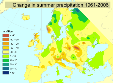
Figure B.1.1b. Changes in the contribution of heavy rainfall to total precipitation 1961-2006
(EEA-JRC-WHO, 2008; Map 5.9). The figure indicates that the proportion of rainfall from heavy falls increases over most areas. Source: The E-Obs dataset from the EU-FP6 project ENSEMBLES (www.ensembles-eu.org) and the data providers in the ECA&D project (eca.knmi.nl).
Objective(s)
The overall goal of EURO4M is to develop the capacity for, and deliver the best possible and most complete (gridded) climate change time series and monitoring services covering all of Europe. These will enable adequate descriptions of the status and evolution of the Earth system components.
Specifically, the objectives of EURO4M are to:
generate time series of observation datasets and reanalyses of past observational data;
build on and integrate existing European in situ and satellite datasets, bearing in mind global connectivity, interoperability and data sharing;
develop the capacity for climate quality dynamic reanalysis that optimally integrates the widest possible range of in situ and satellite data;
demonstrate the capability of regional reanalysis and multi-staged downscaling with increased levels of accuracy;
deliver demonstration regional reanalysis for parts of the past 20 years;
reduce gaps and deficiencies in European monitoring capacity through a better exploitation of existing atmospheric observations and data exchange;
build on the strong synergy the beneficiaries have with other major climate monitoring centres worldwide, in particular with centres involved in global reanalysis.
produce innovative and integrated high-quality data products for research and applications sector users;
produce multi-purpose products and information to assist climate change research to incorporate the monitored ECVs;
provide reliable, up-to-date scientific input (especially through the IPCC) for the implementation of European and international policies and strategies on the environment and society, including the EU climate adaptation strategy;
provide online reporting during emerging extreme events.
reach out with data products and climate change services to the user community, stakeholders, policy-makers, and general public;
demonstrate the climate change services to policy-makers, researchers, planners and citizens at European, national and local levels;
hold frequent dialogues and interactions with a wide range of end-users to achieve a better understanding of information needs and formats;
make the data and information readily accessible to users with full consideration of the appropriate level of aggregation and standardization.
evolve into a future GMES service on climate change monitoring that is fully complimentary and supporting the existing core services.
integrate and extend core GMES services activities on ECVs, specifically developing the capacity required for user-oriented multi-purpose products for monitoring of climate change;
link to existing GMES services, and especially those on marine, land and atmosphere monitoring, which include - or will include in the near future - a global component by design;
stimulate the GMES downstream sector;
demonstrate and strengthen the European leadership in long-term monitoring of climate change.
These objectives will be achieved over a 4 yr period in 4 major Work Packages (WPs) detailed in Section B.1.3. Together, they comprehensively address the scientific, technical and wider societal and policy objectives of the Sub-activity SPA.2009.1.1.02 “Monitoring of climate change issues (extending core service activities)”.
Scope
Variables: EURO4M will focus on atmospheric surface climate (air temperature, sea surface temperature, precipitation, snow cover, air pressure, surface radiation budget, wind speed and direction, water vapour) and upper-air climate (earth radiation budget, upper-air temperature, wind speed and direction, water vapour, cloud properties). These are the majority of the ECVs for the atmosphere defined for the Global Climate Observing System (GCOS) and endorsed by GEO for their System of Systems GEOSS.
Area: EURO4M will cover Europe in its entirety. The extent of the datasets will include Region VI as defined by WMO and Europe as defined by EEA. As an illustration of the typical area that the regional datasets of EURO4M will cover, Figure B.1.1c presents the reanalysis domain of the North Atlantic & European Model (NAE). This includes the whole Mediterranean Sea.[Author ID1: at Sun Oct 25 10:19:00 2009 ]
Resolution: EURO4M will provide multi-decadal gridded datasets down to 25 km horizontal resolution (obtained by direct observations) or 3 km horizontal resolution (obtained by regional reanalysis and downscaling).
Period: EURO4M will include the past 20-150 years. The exact period will differ between the various data sources considered (up to 150 years for in situ data, 30 years for satellite data, and, at this stage, parts of the last 20 years for the regional reanalysis).[Author ID1: at Sun Oct 25 10:24:00 2009 ]
Figure [Author ID1: at Sun Oct 25 10:19:00 2009 ]B.1.1c.[Author ID1: at Sun Oct 25 10:19:00 2009 ] [Author ID1: at Sun Oct 25 10:19:00 2009 ] [Author ID1: at Sun Oct 25 10:19:00 2009 ]Domain of the Met Office operational North Atlantic[Author ID1: at Sun Oct 25 10:19:00 2009 ] [Author ID1: at Sun Oct 25 10:19:00 2009 ]&[Author ID1: at Sun Oct 25 10:19:00 2009 ] [Author ID1: at Sun Oct 25 10:19:00 2009 ]European (NAE) Model, which has a grid-length of 12km and 38[Author ID1: at Sun Oct 25 10:19:00 2009 ] [Author ID1: at Sun Oct 25 10:19:00 2009 ]vertical levels with a top at 39km. In autumn 2009, it will[Author ID1: at Sun Oct 25 10:19:00 2009 ] [Author ID1: at Sun Oct 25 10:19:00 2009 ]move[Author ID1: at Sun Oct 25 10:19:00 2009 ] [Author ID1: at Sun Oct 25 10:19:00 2009 ]to 70 levels with a top at 80km.[Author ID1: at Sun Oct 25 10:19:00 2009 ]
This selection is a compromise between data availability, computer power, and resources dedicated to the project. It aims at finding the optimum given the current state-of-the-art and the user requirements. A more detailed overview of the variables, area, resolution and period is provided in Table B.1.1a for each individual dataset (referring to the forthcoming sections, in particular the list of deliverables in B.1.3.4 and the work packages descriptions in B.1.3.5).
Variables |
Area |
Period |
||
Gridded daily high-resolution dataset (D1.1) |
Precipitation |
Alpine region |
1971-present |
|
GPCC gridded dataset (D1.3) |
Precipitation |
European window |
0.5 degree |
1901-2007 |
E-OBS gridded dataset (D1.4) |
Precipitation, Temperature, Snow cover |
Europe, incl N. Africa |
25 km |
1950-present |
CRU gridded data products (D1.6) |
Potential evapotranspiration and PDSI |
European window |
0.5 degree |
1901-present |
Heliosat gridded dataset (D1.7) |
Surface solar irradiance (SSI), albedo, radiation budget |
European window |
0.05 degree |
1986-2006 |
Integrated HOAPS/GPCC gridded dataset (D1.8) |
Precipitation |
European window |
0.5 degree |
1986-2006 |
ATOVS gridded dataset (D1.9) |
Water vapour |
European window |
90 km |
2004-present |
MSG based gridded datasets (D1.10) |
Precipitation, SSI, Cloud properties |
Europe, incl. N. Africa |
5 km |
2005-present |
Updated and merged station based dataset (D1.12, D1.13) |
Pressure, temperature, precipitation |
All countries bordering the [Author ID1: at Sun Oct 25 10:20:00 2009 ]Mediterranean Sea[Author ID1: at Sun Oct 25 10:20:00 2009 ] |
Points |
From 1850 onwards |
4DVAR-based regional reanalysis (D2.1) |
Complete set of variables |
NAE-region |
12/36 km |
1-2 years |
3DVAR-based regional reanalysis (D2.3) |
Complete set of variables |
HIRLAM region |
25 km |
Most of the past 20 yr period |
Downscaled dataset (D2.4) |
Set of variables |
HIRLAM region |
3-12 km |
Most of the past 20 yr period |
Table B.1.1a. Details of the scope for each data set. Note that the specified resolutions refer to the grid spacing; the effective resolution can be coarser. For the satellite[Author ID1: at Sun Oct 25 10:20:00 2009 ], [Author ID1: at Sun Oct 25 13:01:00 2009 ]GPCC[Author ID1: at Sun Oct 25 10:52:00 2009 ] and[Author ID1: at Sun Oct 25 13:02:00 2009 ] [Author ID1: at Sun Oct 25 13:01:00 2009 ]CRU[Author ID1: at Sun Oct 25 10:52:00 2009 ] datasets[Author ID1: at Sun Oct 25 10:53:00 2009 ], a European window [Author ID1: at Sun Oct 25 10:20:00 2009 ]will be [Author ID1: at Sun Oct 25 10:53:00 2009 ]extracted from the [Author ID1: at Sun Oct 25 10:20:00 2009 ]available [Author ID1: at Sun Oct 25 10:20:00 2009 ]global dataset[Author ID1: at Sun Oct 25 10:20:00 2009 ]s[Author ID1: at Mon Nov 9 07:17:00 2009 ]. [Author ID1: at Sun Oct 25 10:20:00 2009 ]The [Author ID1: at Sun Oct 25 10:21:00 2009 ]extent[Author ID1: at Sun Oct 25 10:20:00 2009 ] of this window will be [Author ID1: at Sun Oct 25 10:21:00 2009 ]the same as for the ground based observations and [Author ID1: at Sun Oct 25 10:20:00 2009 ]the [Author ID1: at Tue Nov 3 10:44:00 2009 ]reanalyses datasets.[Author ID1: at Sun Oct 25 10:20:00 2009 ]
As an illustration of the typical area that the regional datasets of [Author ID1: at Sun Oct 25 10:21:00 2009
]EURO4M will cover[Author ID1: at Sun Oct 25 10:21:00 2009
], Figure B.1.1c presents the reanalysis domain of the North Atlantic & European Model (NAE). This includes the whole Mediterranean Sea. [Author ID1: at Sun Oct 25 10:21:00 2009
]In line with the GMES goals, EURO4M will not stop when the raw (observation and reanalysis) data have been made available. The project will also engage in developing the multi-purpose products and services at the appropriate level of aggregation and processing to respond to a wide range of users and downstream services. This is implemented through [Author ID1: at Sun Oct 25 10:21:00 2009
]issuing [Author ID1: at Sun Oct 25 10:22:00 2009
]the so-called [Author ID1: at Sun Oct 25 10:21:00 2009
]Climate In[Author ID1: at Sun Oct 25 10:21:00 2009
]dicator[Author ID1: at Sun Oct 25 10:22:00 2009
] Bulletins and [Author ID1: at Sun Oct 25 10:21:00 2009
]establishing [Author ID1: at Sun Oct 25 12:14:00 2009
]the [Author ID1: at Sun Oct 25 10:21:00 2009
]Climate Liaison Team[Author ID1: at Sun Oct 25 10:21:00 2009
] (see below).[Author ID1: at Sun Oct 25 10:21:00 2009
]
Figure [Author ID1: at Sun Oct 25 10:24:00 2009
]B.1.1c.[Author ID1: at Sun Oct 25 10:24:00 2009
] [Author ID1: at Sun Oct 25 10:24:00 2009
] [Author ID1: at Sun Oct 25 10:24:00 2009
]Domain of the Met Office operational North Atlantic[Author ID1: at Sun Oct 25 10:24:00 2009
] [Author ID1: at Sun Oct 25 10:24:00 2009
]&[Author ID1: at Sun Oct 25 10:24:00 2009
] [Author ID1: at Sun Oct 25 10:24:00 2009
]European (NAE) Model, which has a grid-length of 12km and 38[Author ID1: at Sun Oct 25 10:24:00 2009
] [Author ID1: at Sun Oct 25 10:24:00 2009
]vertical levels with a top at 39km. In autumn 2009, it will[Author ID1: at Sun Oct 25 10:24:00 2009
] [Author ID1: at Sun Oct 25 10:24:00 2009
]move[Author ID1: at Sun Oct 25 10:24:00 2009
] [Author ID1: at Sun Oct 25 10:24:00 2009
]to 70 levels with a top at 80km.[Author ID1: at Sun Oct 25 10:24:00 2009
]
Key scientific question
The key scientific question EURO4M addresses is: “How can we improve monitoring to help us better understand and predict climate change, extremes and weather related hazards, so that society can respond in the best possible way?”
In order to place recent changes, fluctuations and extremes in their long-term perspective, optimal usage of all conventional (in situ) and satellite sources will be required. EURO4M will achieve this by seamless integration of data from the satellite era (back to the 1970s) with early instrumental observations (back to the mid-19th century). A vital approach to integrating these quantities is for EURO4M to explore the use of new regional reanalysis as well as existing global reanalyses, especially ERA-40 (Uppala et al., 2005).
The focus on extremes and weather related hazards requires more detail than is strictly necessary for GCOS global climate monitoring, because as a potential future GMES service on climate change monitoring, we need to fully satisfy the information needs for sub-regional and local adaptation measures. It is at those scales where climate and weather impacts are most strongly experienced. High impact extreme events range from those of short duration (such as heavy rain and associated flooding, and windstorms) to those which extend over several days (heat waves, atmospheric pollution), several months or perhaps even years (drought). They also range from continental-to-local spatial scales.
The science included in EURO4M (in particular in WPs 1 and 2; see Section B.1.3) ensures that the overall goal of developing the capacity for, and delivering the best possible and most complete (gridded) climate change time series and monitoring services for Europe will be achieved at a high scientific level. We combine two different but complementary approaches: regional observation datasets of ECVs on the one hand and model based regional reanalysis on the other. Choosing direct observations alone would have left the potential of data assimilation unexplored; choosing reanalysis only would have run the risk of missing some important aspects in the observations and might have compromised the quality of the final monitoring products and services. We are convinced that integrated climate change monitoring products of state-of-the-art quality are needed, because most of the work in downstream GMES services and GEO areas will be based on this information.
Role of reanalysis
A reanalysis of the past atmospheric state can be obtained by combining observational datasets with a comprehensive Numerical Weather Prediction (NWP) model. Using modern data assimilation methods, a complete estimate of the atmospheric state is computed that is both dynamically consistent and optimally close to the observations. The great benefit of a reanalysis is that it provides a complete picture of the atmosphere covering the whole of the three-dimensional domain, also for the ECVs and parameters which are not routinely monitored by observations.
In a reanalysis (or rather re-assimilation) also, the consistency in time is ensured through the forecast model used in the data assimilation cycles. It carries the information from cycle to cycle with dynamical changes in order to give a best background before the observations are analysed. This 4-dimensional dynamical consistency is strong both in 3D and 4D assimilation algorithms. In 4D variational assimilation (4D-VAR) the consistency is even stronger within each time window. The dynamical model trajectory is fitted as closely as possible (as given by model and observation statistics) to all the observations within the time window of 4D-VAR (6-12 hours). It means that also atmospheric tendencies are well assimilated and the resulting analysis fields provide better estimates of moist variables like precipitation rates and cloud cover compared with what 3D methods give.
The availability of forecast model fields in the assimilation cycles provides a whole range of diagnostic quantities like radiative fluxes and accumulated precipitation where there are no observations. The accuracy of these is of course limited by the quality of the forecast model, but by basing reanalysis systems on state-of-the-art operational NWP models, we benefit from past careful validation and model development in the operational centres. Experience from global reanalyses has shown that there is a potential in the use of such model-derived quantities.
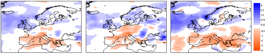
The benefit of complete multi-decadal sets of ECV products motivates EEA to investigate the use of reanalysis for future assessment studies and explore possibilities for a regional analysis in Europe (the EURRA project). However, current reanalysis products are not yet reliable enough to satisfy user needs entirely, because the basic raw observations and measurements are not consistently of climate quality. Problems arise partly because the assimilating numerical model is inevitably biased to some degree in its representation of the climate system. If observations are abundant and unbiased, they can correct the biases in background forecasts when assimilated (Simmons et al., 2004). In reality, however, observational coverage varies over time, observations are themselves prone to bias, either instrumental or through not being representative of their wider surroundings, and these observational biases can change over time. This introduces trends and low-frequency variations in analyses that are mixed with the true climatic signals (see Figure B.1.1d).

mm/yr
Figure B.1.1d. Changes in summer (JJA) rainfall since 1961 estimated from different sources:
a) the E-Obs dataset based on station observations (see Figure 1.1b);
b) UKCIP08 (Jenkins et al., 2007);
c) ERA-40 reanalysis (ECMWF)
The difference in trends over the UK illustrates the biases in existing global reanalysis products.
Moreover, the limited spatial resolution of current models that are affordable for global reanalysis inhibits the applicability of products for the study of local climate change and extremes.
Progress in the provision of reanalyses suitable for climate monitoring requires improvements in data assimilation systems, both in assimilating models and the analysis methods used to incorporate observational information, and improved recovery, quality control and bias correction (or homogenization) of past observations. Assessment of existing products through comparison either with high quality regional datasets or alternative global ECV products is a further important activity needed both to guide potential users as to the applicability of the products they are using and to guide where the emphasis needs to be placed for the improvement of the production systems.
EURO4M will enhance the quality of regional reanalysis methods and deliver different levels of advanced regional reanalysis datasets for Europe. Some of these datasets will cover most of the last 20 years, whereas other more advanced systems will be demonstrated for a few years. There will be improvement of data assimilation systems,
in resolution, and in the use of precipitation and surface data. Selected products will be evaluated in detail, comparing also with existing products from global reanalyses.
In order to further enhance the horizontal resolution and detailed structures of the regional reanalyses, EURO4M will also perform 2-dimensional downscaling at a considerably higher resolution than is possible with the 3D (or 4D) methods. The 2D analysis methods still combine observations with background fields from the 3D regional system, but the analysis methods are relaxed from fulfilling all the 3-dimensional balance constraints that are required for NWP. In the 2D analyses one employs a lot of regional variation given by observational statistics and by physiographic factors (land-sea and orography, mainly). In this way it is possible to analyse fine scale structures given by observations and closer to the observations than the full 3D systems can do.
We will also prepare bias-adjusted observed data inputs to climate quality reanalyses in close cooperation with ECMWF. We will contribute to the improved capability for reanalysis needed to ensure that the next generation of longer-term global and regional reanalysis is as well prepared as possible to meet the needs of climate monitoring. Our third party participant ECMWF (see Section B.2.3) strongly supports this activity and will collaborate by providing the current ERA-Interim reanalysis, the raw observations and by exchanging ideas on the formats of observation files, monitoring techniques and any other possible commonalities between the regional reanalysis in EURO4M and the global reanalysis.
Role of satellite data and derived products[Author ID1: at Sun Oct 25 10:25:00 2009 ]
Satellite-derived products will supplement the reanalysis data and ground measurements. Over the oceans and sparsely populated areas satellite data are often the only data source. The quality of cloud information, the surface radiation budget, water vapour and precipitation can be significantly increased by use of satellite data within the integrated data products. The top of the atmosphere radiation budget can be only observed by satellites.
Satellite products (e.g. water vapour, cloud properties, sea ice and shortwave radiation) together with ground-based measurements will also be used to verify the reanalysis data. Biases in the radiances of satellite sensors, e.g. due to missing inter-calibration, lead to biases or breaks of homogeneity in reanalysis data as the models themselves cannot absolutely correct biases in grossly inhomogeneous input data. Satellite radiances are already assimilated into reanalysis datasets. In order to improve the homogeneity of reanalysis data, EURO4M will support satellite inter-calibration activities. The sensitivity of reanalysis ECVs for inhomogeneities and biases in satellite radiances will be evaluated.
Satellite data will be used together with reanalysis data to provide a long-term record of the surface radiation budget. Climate indices derived from satellite-based products are of value for monitoring of specific climate impacts (e.g. droughts in Wang and Qu, 2007). Additionally, the commercial solar energy market demonstrates the suitability of satellite data for climate applications. E.g. satellite-based solar irradiance data are used for the efficient planning and monitoring of solar energy systems (Hammer et al. 2003; Drews et al. 2008).
The product palette of the CM-SAF has been evaluated to be suitable for monitoring of climate change (Schultz et al., 2008). However, the overall capacity of satellite-derived data for climate monitoring has by no means been explored satisfactorily. EURO4M will integrate the EUMETSAT-SAF products and methods for climate monitoring. In this respect, reprocessing of existing satellite products in order to derive homogeneous long-term datasets is an important effort. At the same time, there is scope for merging these products with shorter-term but possibly more advanced datasets.
Climate Indicator Bulletins and Climate Liaison Team
T[Author ID1: at Sun Oct 25 10:25:00 2009
]Whereas t[Author ID1: at Sun Oct 25 10:25:00 2009
]he raw data from EURO4M will be distributed mainly through existing systems, which can be accessed from a dedicated EURO4M web-based data portal.[Author ID1: at Sun Oct 25 10:25:00 2009
] and t[Author ID1: at Sun Oct 25 10:26:00 2009
] T[Author ID1: at Sun Oct 25 10:26:00 2009
]he scientific results will be distributed[Author ID1: at Sun Oct 25 10:26:00 2009
] through peer-reviewed scientific and technical journals. [Author ID1: at Sun Oct 25 10:26:00 2009
]In addition[Author ID1: at Sun Oct 25 10:56:00 2009
], the EURO4M multi-purpose products will be disseminated through regularly issued Climate Indicator Bulletins (CIBs). These will focus on user groups (such as [Author ID1: at Sun Oct 25 10:27:00 2009
]disaster prevention, health, energy, water resources, ecosystems, forestry agriculture, transport, tourism and biodiversity) at [Author ID1: at Sun Oct 25 10:27:00 2009
]Eur[Author ID1: at Sun Oct 25 10:27:00 2009
]opean, national and local levels.[Author ID1: at Sun Oct 25 10:27:00 2009
]and downstream services[Author ID1: at Sun Oct 25 10:27:00 2009
] In general, these user groups[Author ID1: at Sun Oct 25 10:27:00 2009
] that[Author ID1: at Sun Oct 25 10:27:00 2009
] do not have the required expertise and knowledge to access and process the Terabytes of raw observation data or reanalysis data. CIBs will provide simple, effective and timely knowledge abstractions from EURO4M data and activities. The CIBs will be flexible and optimal products that will be responsive to current environmental and climatic events, extremes and also user needs. [Author ID1: at Mon Nov 9 07:18:00 2009
]
The exact specifications for the CIBs will be developed as part of the project, with “proof of concept” undertaken for selected extreme events from the past, such as the heat wave of 2003.[Author ID1: at Sun Oct 25 10:28:00 2009 ] [Author ID1: at Sun Oct 25 10:29:00 2009 ]Apart from[Author ID1: at Tue Oct 27 12:20:00 2009 ] multi-purpose[Author ID1: at Tue Oct 27 12:41:00 2009 ] [Author ID1: at Tue Oct 27 12:20:00 2009 ]information on[Author ID1: at Sun Oct 25 10:30:00 2009 ] changes and significant anomalies [Author ID1: at Sun Oct 25 10:34:00 2009 ]for[Author ID1: at Sun Oct 25 10:56:00 2009 ] ECVs, u[Author ID1: at Sun Oct 25 10:30:00 2009 ]ser[Author ID1: at Sun Oct 25 10:29:00 2009 ]-[Author ID1: at Tue Oct 27 12:20:00 2009 ]oriented derived[Author ID1: at Sun Oct 25 10:57:00 2009 ] indices[Author ID1: at Sun Oct 25 10:29:00 2009 ] will also [Author ID1: at Sun Oct 25 10:31:00 2009 ]be [Author ID1: at Tue Oct 27 12:20:00 2009 ]included[Author ID1: at Sun Oct 25 10:31:00 2009 ], such as[Author ID1: at Sun Oct 25 10:29:00 2009 ] heating degree days[Author ID1: at Sun Oct 25 10:30:00 2009 ], [Author ID1: at Sun Oct 25 10:32:00 2009 ]number of [Author ID1: at Sun Oct 25 10:57:00 2009 ]high intensity precipitation events, etc[Author ID1: at Sun Oct 25 10:32:00 2009 ].[Author ID1: at Sun Oct 25 10:31:00 2009 ] The CIBs will be based on the output datasets available at the time of CIB writing. This implies that the CIBs do not rely on the datasets that will be delivered late in the project.[Author ID1: at Tue Oct 27 12:34:00 2009 ] [Author ID1: at Sun Oct 25 10:28:00 2009 ]The [Author ID1: at Sun Oct 25 10:28:00 2009 ]CIBs will be published both as bulletins (electronic documents/newsletters) as well as being provided through a web-portal, including access to the associated data series, gridded datasets and editorial texts. The system for producing CIBs will be made configurable and flexible, and capable of reacting in near-real time to user needs.[Author ID1: at Sun Oct 25 10:28:00 2009 ]
Within EURO4M a Climate Liaison Team (CLT) will actively solicit user requirements and feedback. Through their mediation, the multi-purpose results of EURO4M will feedback directly into applications and impact assessments relevant to European societal and community needs. The Climate Liaison Team (CLT) will establish a communication process, which responds to information flow in both directions (providers > users and users [Author ID1: at Sun Oct 25 10:33:00 2009 ]>[Author ID1: at Sun Oct 25 10:34:00 2009 ] providers) and evolves through time, so that users can both obtain and influence the nature (user[Author ID1: at Sun Oct 25 10:33:00 2009 ]-[Author ID1: at Tue Oct 27 12:21:00 2009 ]driven data format, content and delivery style) of the information they need while understanding the strengths and limitations of the monitoring products. In doing so, the team will establish sustainable links between EURO4M and all GMES services and GEO societal benefit areas.[Author ID1: at Sun Oct 25 10:33:00 2009 ][Author ID1: at Sun Oct 25 10:33:00 2009 ]
The CLT will also train users in the handling of EURO4M products and services through workshops, e-learning modules, podcasts and user guides covering different skill levels. In this way, EURO4M will ensure stronger links between European applications studies and the outputs from traditional and advanced climate monitoring systems.
The existing core GMES services and the downstream GMES services, which are currently planned and positioned between the multi-purpose core services and the individual user clients, will be actively involved in the CLT. This will ensure that the end-users can and will take full benefit of the wide range of products and services EURO4M will develop. The CLT will build on existing national experience and related ERA-Net activities, such as the ERA-Net: Climate Impact Research Coordination within a Larger Europe (CIRCLE; see Section B.3.1 and Kabat and Vellinga, 2005). The lessons learned from the process for establishing user needs that has been used for the selection of fast track and pilot services will be considered too. The CLT enables that, already in an early stage, users are involved in the decision-making process in a structured way. This is in line with the user-driven objective of GMES (EC, 2008).
B.1.2 Progress beyond the state-of-the-art
Innovation-related activities
Never before has the pan-European integration of atmospheric observations from ground-based sources, satellite sources and reanalysis been optimized in such a comprehensive way for long-term climate monitoring and adaptation policy support. Remotely sensed data from satellites deliver near-real time estimates of key parameters worldwide. However, they must be complemented by in situ data, even though these are often much more sparsely and irregularly distributed in time and space. The in situ data are indispensable for calibration and validation of satellite data. Also they give information representative of a finer spatial scale, often with higher precision, which complements satellite information which is coarser, but has wider coverage.
The problems with estimates of lower tropospheric temperatures from satellite-based Microwave Sounding Unit (MSU) radiances since 1978, and their subsequent comparisons with sonde-based and surface temperature data, indicate that datasets need to be considered together rather than in isolation. In contrast to satellite data, in situ measurements have often been acquired and handled by a wide variety of laboratories and institutions for the purposes of specific research programmes and are not managed in a unified way.
Climate quality reanalysis
The data assimilation and downscaling activities in EURO4M will progress the regional reanalysis science beyond the present state-of-the-art. The data assimilation systems are making rapid progress as they benefit from research in NWP, which has lead to much improved weather-forecast skill. Also, progress is made in the correction of biases and discontinuities of the observing system that obscure the detection of climate trends. Computing resources are growing with time, which will enable future reanalyses to be calculated at finer horizontal and vertical resolutions, with immediate effects on product quality and on the relevance of products for new applications.
An example of what can be achieved is provided by the National Centers for Environmental Prediction (NCEP) North American Regional Reanalysis (NARR). This long-term, consistent, high-resolution climate dataset for the North American domain is a major improvement upon the earlier global reanalysis datasets in both resolution and accuracy (Mesinger et al., 2006). At 32 km horizontal resolution, NARR covers the 25-yr period 1979-2003 and is being continued in near-real time. In particular, NARR has successfully assimilated high-quality and detailed precipitation observations into the atmospheric analysis. Consequently, the forcing to the land-surface model component of the system is more accurate than in previous reanalyses, so that NARR provides a much-improved analysis of land hydrology and land-atmosphere interaction. The overall atmospheric circulation throughout the troposphere has been substantially improved as well.
Operational agencies responsible for reanalysis need to be kept abreast of advances in data recovery and rehabilitation, which will lead to improvements in datasets for assimilation in reanalysis. In the long run, new “climate quality” dynamic reanalyses will then be able to provide the necessary ECVs. This requires data from a network of radiosonde, surface-based, and satellite-based observations that are specifically pre-validated with respect to systematic biases. The models themselves cannot absolutely correct biases in grossly inhomogeneous input data. Incorrect or incomplete data with spatio-temporal inhomogeneities can be misleading in estimating climate change, in particular changes in extremes. Recovery of synoptic surface meteorological data and radiosonde upper-air data is needed to fill gaps in the observational records held by reanalysis centres. Major efforts are needed to bring together more of the available data into a coherent form suitable for climate quality reanalyses. For instance, existing reanalysis products did not use all corrected surface-based and radiosonde observations. For the early years, much better exploitation of existing and digitized high-resolution observational series can be made. EURO4M will therefore extend these data back well before 1958 (the start date of ERA-40) to serve future reanalysis prior to this time, e.g. the proposed next generation reanalysis that ECMWF plans to carry out, with “proof of concept” being undertaken by the global reanalysis proposal for FP7 should it be successful (see Section B.2.3). The project will also link with the ACRE-facilitated reanalyses to aid the development and testing of a 100+ year reanalysis using only surface observations (the 20th Century Reanalysis Project), and thus be positioned to work similarly with even longer historical climate quality reanalyses.
Essential Climate Variables (ECVs) state-of-the-art
The Second Adequacy Report of GCOS (GCOS, 2003) developed the concept of Essential Climate Variables (ECVs) encompassing the atmospheric, oceanic and terrestrial domains. The concept forms part of the GCOS Implementation Plan (GCOS, 2004), which for these three domains has been endorsed by GEO in its GEOSS work plan (GEO, 2007). The GCOS Implementation Plan has been updated with the help of EURO4M partners. The new report (GCOS, 2009) provides a comprehensive assessment on the status and trends in global observing systems for climate over the past five years, as well as on progress in related activities (research, infrastructure, organizational issues). GCOS named the ECVs in a somewhat ad hoc way. Some are very specific physical quantities, e.g. surface temperature and precipitation, while others are more vague and generic, e.g. cloud properties and minor greenhouse gases, encompassing a number of measurements. Some can be considered at point locations, while others only really have scientific relevance as global fields.
EURO4M will consider a selection of ECVs from the atmospheric domain, which comprises 6 surface level, 5 upper atmosphere ECVs, and only one ECV from each of the oceanic and terrestrial domains (see Table B.1.2a).
Domain |
Essential Climate Variables (ECVs) |
|
Atmospheric (over land, sea an ice) |
Surface:
Upper-air:
Composition: |
Air temperature, Precipitation, Air pressure, Surface radiation budget, Wind speed and direction, Water vapour Earth radiation budget, Upper-air temperature, Wind speed and direction, Water vapour, Cloud properties Carbon dioxide, Methane, Ozone, Other long-lived greenhouse gases, Aerosol properties |
Oceanic |
Surface:
Sub-surface: |
Sea-surface temperature, Sea-surface salinity, Sea level, Sea state, Sea ice, Currents, Ocean colour, CO2 partial pressure Temperature, Salinity, Currents, Nutrients, Carbon, Ocean tracers, Phytoplankton |
Terrestrial |
River discharge, Water use, Ground water, Lake levels, Snow cover, Glaciers and ice caps, Permafrost and seasonally-frozen ground, Albedo, Land cover, Fraction of absorbed photosynthetically active radiation, Leaf area index, Biomass, Fire disturbance. |
|
Table B.1.2a. GCOS ECVs: Those that will be part of EURO4M are shown in bold.
Specific reasons for this selection of ECVs are justified in the assessment below. The general motivation is that these ECVs form primary input to all GMES services and GEO societal benefit areas and that most services and areas currently make suboptimal use of existing information. Often the changes in extremes that accompany the average warming are not taken into account. Also, most of the other ocean and terrestrial ECVs are part of other core GMES services. With several other projects underway that are fully dedicated to monitoring the atmospheric composition (such as CarboEurope and NitroEurope), these ECVs are not considered within EURO4M.
Baseline for each ECV:
ECV: Surface Temperature
The best-known product for monitoring surface temperature, using a combination of land station data and in situ sea surface temperature observations, has been developed by the Climatic Research Unit of UEA and the MO. The current version of the monthly dataset, which extends back to 1850, is HadCRUT3 (Brohan et al., 2006) but its spatial and temporal resolutions of 5° by 5° latitude/longitude and monthly timescale are rather coarse. A higher resolution version, back to 1901 at 0.5° by 0.5° spatial resolution, is available for land areas only (Mitchell and Jones, 2005) but the temporal resolution is still monthly. Sea surface temperature data is well studied (as it is a vital input to Reanalyses) and datasets such as HadISST and HadSST2 (Rayner et al., 2006) are readily available. National Meteorological and Hydrological Services (NMHSs) have collected most of the historical station temperature data, but only a few have digitized their entire daily to sub-daily holdings. Fewer still have homogenized their long series. Some additionally charge for accessing this type of data.
Recent EU projects EMULATE (European and North Atlantic daily to MULtidecadal climate variability), ENSEMBLES (ENSEMBLE-based Predictions of Climate Changes and their Impacts), STARDEX (Statistical and Regional dynamical Downscaling of Extremes for European regions), IMPROVE (Improved Understanding of past climatic variability from early daily European instrumental sources), CIRCE (Climate change and impact research: the Mediterranean environment) and ECA&D have assembled daily series of maximum and minimum temperature, all of which will be available to EURO4M. ENSEMBLES and STARDEX have emphasised high spatial density observations, but over relatively short periods from the 1950s. EMULATE, CIRCE and ECA&D concentrated on records that extended back to the 19th century, but their databases were limited to about 200 records, and spatial gaps continue to affect Europe. ENSEMBLES has produced a daily gridded dataset at a resolution of 25 by 25 km for statistical comparisons with Regional Climate Model output (Haylock et al., 2008). Higher-resolution (3 hourly) data are also digitally available from the Integrated Surface Hourly (ISH) dataset. These are discussed under the surface humidity ECV, but Integrated Surface Hourly (ISH) temperatures will also be investigated in EURO4M.
In summary, temperature is the ECV for which most digitized data are readily available, and it is also the most widely analyzed variable. Some spatial limitations affect Europe in the daily series, and there are concerns about the long-term homogeneity of the records (Wijngaard et al., 2003).
ECV: Precipitation
Gridded precipitation datasets are available at 0.5°, 1° and 2.5° resolution from the WMO Global Precipitation Climatology Centre (GPCC) operated by DWD. These are at the monthly timescale, extend back to 1951, have global coverage (land-surface), and use between 10,000 and 40,000 individual station series (Rudolf and Schneider, 2005, Beck et al., 2005). Since the late 1970s, it has been possible to incorporate satellite precipitation estimates, although these raise a myriad of issues regarding the types of satellite sensors used and the algorithms which convert sensor measurements into surface precipitation rates. Accordingly, global datasets of precipitation have been constructed by the Global Precipitation Climatology Project (GPCP) and NOAA's Climate Prediction Center Merged Analysis of Precipitation, both being available at 2.5° resolution. Blending of the ground-based GPCC precipitation dataset with the satellite-based HOAPS dataset (Hamburgs Ocean Atmosphere Parameters from Satellite; Grassl et al., 2000; Bauer and Schluessel, 1993) lead to a global precipitation dataset covering both land surface and ocean (Figure B.1.2a).
Figure B.1.2a: Annual average precipitation amount derived by blending GPCC with HOAPS-3. DWD will generate a blend of HOAPS-4 and GPCC, which will comprise 20y of global precipitation over land (GPCC) and ocean (HOAPS).
Slightly more digitized daily records are available for precipitation than temperature across Europe, but given the much greater spatial variability of precipitation, a much greater density is essential. This is particularly the case for mountain regions (Frei and Schär 1998). ENSEMBLES has produced a daily gridded dataset at a resolution of 25 by 25 km for statistical comparisons with Regional Climate Model output (Haylock et al., 2008). In specific regions and projects (e.g. the Alps, the Baltic Sea Experiment (BALTEX), the European Land Data Assimilation System to predict Floods and Droughts (ELDAS) and for many individual countries), much denser networks have been used in regional and national studies. Gridded versions of these data will be used to assess the accuracy of interpolation in ENSEMBLES (extending the initial work reported by Hofstra et al., 2008). As for temperature, CIRCE aims at collecting, updating and homogenising daily precipitation station series from the larger Mediterranean area covering the last decades to 100 years. The WMO MEDARE initiative aims at pushing this limit even further back in time and recover additional series from this region.
In summary, precipitation data need to be more spatially extensive than temperature to achieve a given level of accuracy in regional-scale estimations. There are again limitations with the availability of digitized data across Europe, and although there are fewer concerns about homogeneity, this may be because the density of networks is inadequate to address this issue (Auer et al., 2005). EURO4M will have access to daily station series as well as gridded products from GPCC, EMULATE, ENSEMBLES, CIRCE and MEDARE (see Section B.1.3).
ECV: Atmospheric Air Pressure
Most analyses of atmospheric circulation in the scientific literature during the last few years make use of reanalyses (ERA-40 or NCEP/NCAR). However, efforts to examine circulation patterns over longer time scales have focused on observational datasets of atmospheric pressure. Foremost amongst these, using both global terrestrial ISPD and marine ICOADS data at monthly timescales back to 1850 (and at 5° by 5° spatial resolution), is the Hadley Centre mean Sea Level Pressure dataset, Version 2 (HadSLP2) compiled by MO (Allan and Ansell, 2006). The same institution led the EMULATE project in its development of a daily (24 hour mean) mean sea level pressure (MSLP) product from 1850, also including both terrestrial and marine ICOADS data at the same resolution (EMSLP), but only for the North Atlantic-European region 25-70°N by 70°W-50°E (Ansell et al. 2006). EMULATE made extensive use of earlier EU-funded projects that digitized long daily pressure series, such as WASA (Waves and Storms in the North Atlantic) and IMPROVE. The basic terrestrial and island station pressure data in the ISPD and the marine measurements from ICOADS, that are the basis of the above gridded datasets, are being expanded and improved through the Atmospheric Circulation Reconstructions over the Earth (ACRE) initiative (led by MO) and will be available for EURO4M. The importance of atmospheric air pressure for climate change monitoring is illustrated by Figure B.1.2b from IPCC-WGI-AR4. Here, SMHI have used station data to indicate evidence for changes in extratropical cyclone activity (storminess).
Efforts are underway at MO via the ACRE initiative and its links to the 20th Century Reanalysis Project of its US collaborators, to develop the combined ISPD and ICOADS global sub-daily MSLP databases for climate quality surface-observations-only reanalyses extending back to 1891. Additional ACRE-facilitated historical reanalyses using only surface observations are planned to extend these reconstructions back over the last 150 years globally and for the North Atlantic-European region to the mid-18th century. The development of the combined ISPD and ICOADS sub-daily MSLP dataset needed for such activities will be closely linked to EURO4M activities in WP1. All of these new MSLP data activities are structurally, but not financially, supported by GCOS through the AOPC/OOPC Surface Pressure Working Group.
Station pressure data are rarely analyzed in isolation (except for the WASA work with pressure triangles) and most studies derive MSLP fields. For Europe, these fields are generally adequate, but will be improved and extended back in time over both the land and oceans by the ACRE project. Improvements are required for sub-daily fields and in marine data in some parts of the world, and new surface-observations-only reanalyses should begin to address these deficiencies.
Figure B.1.2b: Storm index for the British Isles, North Sea and Norwegian Sea, 1881 to 2004. Blue circles are 95th percentiles and red crosses 99th percentiles of standardised geostrophic winds averaged over 10 sets of triangles of stations. The smoothed curves are a decadal filter (updated by SMHI from Alexandersson et al., 2000; see Figure 3.41 in IPCC-WGI-AR4).
ECV: Surface and Earth Radiation
The surface radiation budget is a fundamental component of the surface energy budget that is crucial to nearly all aspects of climate. The Baseline Surface Radiation Network (BSRN) of the World Climate Research Programme (WCRP) has established the relevant measurement techniques and is now recognized as the GCOS baseline network for surface radiation. The BSRN provides high-quality but spatially limited measurements of radiation at the surface. The GCOS action to expand the BSRN network, increasing the number of land stations and using research ships and buoys over the ocean is an important step. However, additional data are needed to obtain a sufficient spatial coverage for climate monitoring. As with most GCOS actions and plans, the initiatives and financial resources must come from the scientific community, principally through the member states and their NMHSs.
Satellite data can be used to monitor clouds and surface solar radiation quite well. Hence BSRN stations in combination with satellites are a powerful option for an appropriate monitoring of the surface radiation with high accuracy and spatial coverage. The International Satellite Cloud Climatology Project (ISCCP), the Earth Radiation Budget Experiment (ERBE), as well as the CM-SAF Climate Data Records will be used within EURO4M. The potential of merging in situ data with satellite-derived data will be investigated in WP1.
In addition, reanalysis data has the potential to contribute to the appropriate monitoring of radiation ECVs. Trentmann et al. (2008) has recently evaluated the thermal flux densities at the surface of the ERA-Interim dataset and concludes that this has a high accuracy and can therefore be used in conjunction with satellite-based shortwave surface radiation fluxes in order to provide the surface radiation budget and its components in climate accuracy. Of course, monitoring the radiation budget at the top of the atmosphere cannot be based on surface data, but needs satellite data. WP2.4 will address the accuracy of reanalysis data by comparison with the radiation budget derived with GERB/CERES (Geostationary Earth Radiation Budget/Clouds and the Earth's Radiant Energy System) and ERBE data.
One of the radiation budget components, the surface solar radiation, is necessary for an efficient planning and monitoring of solar energy systems (Hammer et al, 2003; Drews et al., 2008). Surface solar radiation is also important for the satellite-based estimation of drought and evaporation (Wang and Liang, 2008; Wang and Qu, 2007).
ECV: Wind Speed and Direction
This ECV is measured at many stations across Europe, but because of local effects, studies of longer-term changes in high wind speeds during storms generally make use of daily and sub-daily MSLP fields (from reanalyses or from the EMULATE and WASA projects) as these are generally more consistent through time.
Figure B.1.2c illustrates the use of reanalysis data for the reconstruction of past extreme wind storm events. The violent storms that swept Western and central Europe from 25 to 28 December 1999, left more than 60 dead.
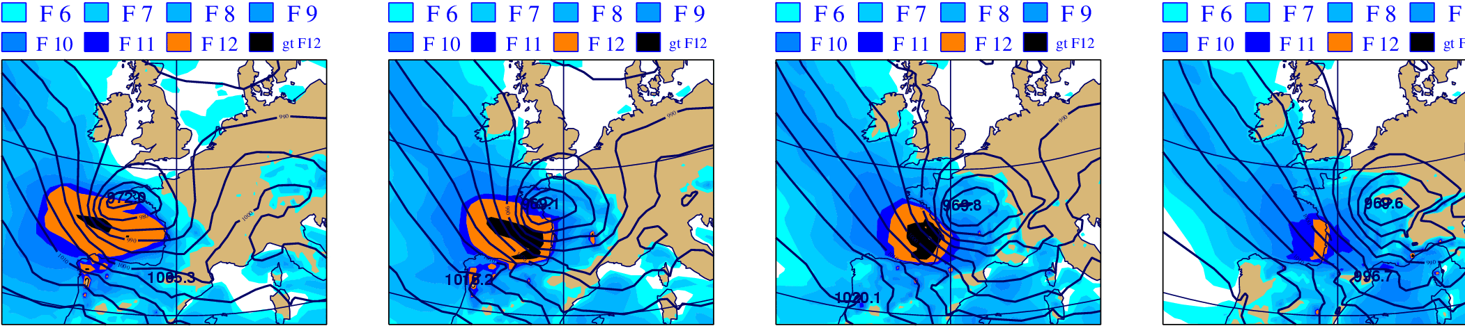
Figure B.1.2c: Reconstruction of the 1999 “Christmas” storms using ERA-40 reanalysis data.
This example shows the wind field of 27 December 1999 at 00 UTC.
Colours indicate wind speed in Beaufort scale F (source: ECMWF).
ECV: Surface Humidity
HadCRUH is a new dataset of monthly mean surface humidity anomalies at 5°×5° resolution, covering the period 1973-2003, with respect to the 1974-2003 climatology (available at www.hadobs.org ; see Willett et al., 2007; 2008). It is nearly global in coverage, combining land data from observing stations and marine data from ships, buoys and observing platforms. The land data are sourced from version 2 of the integrated surface hourly (ISH) dataset, supplied by the National Climatic Data Center. The marine data are sourced from release 2.1 of ICOADS (International Comprehensive Ocean-Atmosphere Dataset) for 1973-1997 and from NCEP GTS data (Global Telecommunications System data made available through NOAA's National Centers for Environmental Prediction) for 1998-2003. HadCRUH is available in specific humidity and relative humidity forms. This dataset uses all available humidity observations (vapour pressure, relative humidity and dew point temperature). EURO4M will analyse the dataset for changes over the last 30 years. The GTS dataset will also be investigated for some of the other surface ECVs (e.g. temperature and pressure), as it will likely provide sub-daily resolution for the European domain.
ECVs: Upper Air Temperature/Upper Air Humidity/Wind Speed and Direction
Upper-air temperatures, humidities and wind speeds/directions from radiosondes are a cornerstone of the data input to most reanalyses. However, improvements in the response times and radiative shielding of instruments on the sondes mean that all upper-air temperatures and humidities are subject to major heterogeneities throughout the 50+ yr record. A significant change to ascent times took place in 1957, partly explaining why ERA-40 begins in 1958. Changes to the times of the sonde ascents can affect the long-term homogeneity of the derived series through changes in the effect of radiation on the sensors as well as through the true, though small, diurnal cycle of atmospheric temperature. Some important advances in radiosonde homogeneity have been made in recent years, e.g. Thorne et al. (2005a, b) and the MO gridded radiosonde temperature dataset (HadAT). At the National Climatic Data Center (NCDC, US), many of the original sonde ascents were collected or digitized in the Integrated Global Radiosonde Archive (IGRA; Durre et al., 2006).
WP2 will benefit significantly from previous work using data from both HadAT (homogeneity adjustments, see Titchner et al., 2008) and IGRA (additional pre-1979 ascents). Data homogenization by near neighbour-comparisons, and by reference to reanalysis feedback files (e.g. by Haimberger et al., 2008), will be incorporated into improved analyses for the European-North Atlantic region.
ECV: Cloud Properties
Cloud feedback is considered to be the single most uncertain aspect of future climate projections and is responsible for much of the wide range of estimates of climate sensitivity in climate models. Therefore, it is vital to maintain long-term records of cloud properties. Satellite data, for example constructed by ISCCP, provide an appropriate basis for monitoring of cloud parameters. EURO4M will deliver a number of new cloud property datasets produced within the framework of the CM-SAF (including a 20+ yr cloud albedo dataset). Monitoring of developments within ISCCP and a liaison with AOPC will ensure that the most up-to-date information is used. A metric for evaluation of reanalysis cloud data will be developed using ISCCP, CM-SAF and cloud products derived in WP2.1.
ECV: Snow cover
This ECV is classed by GCOS as being in the terrestrial domain, but it has traditionally been measured by NMHSs. Thus across northern and high-elevation areas of Europe, there are long daily records of station-observed snow cover, many of which are digitally available. In addition to the in situ observations, satellites have measured snow cover since about 1966. Fields of snow cover have been quite deficient in previous reanalyses, and experiments with improved fields will be investigated within WP2. Data for this ECV will also be available through interactions between EURO4M and the EuroCryoClim project for high latitude Europe and the Arctic.
The baseline datasets which serve as an input for EURO4M, their respective sources and the way the consortium has access to these sources (including GMES core services and/or ESA data if applicable) are detailed in Table B.1.2b.[Author ID1: at Sun Oct 25 10:36:00 2009
]
Table[Author ID1: at Sun Oct 25 10:36:00 2009
] [Author ID1: at Sun Oct 25 10:36:00 2009
]B.1.2b[Author ID1: at Sun Oct 25 10:36:00 2009
]. [Author ID1: at Sun Oct 25 10:36:00 2009
]Baseline datasets used in EURO4M[Author ID1: at Sun Oct 25 10:36:00 2009
].[Author ID1: at Sun Oct 25 10:36:00 2009
][Author ID1: at Sun Oct 25 10:36:00 2009
]
Performance / research indicators
The criteria for the project along which results, progress and impact of the project will be measured in later reviews and assessments are: timeliness of CIBs, datasets, reports and papers (see deliverables) and usage of this information by stakeholders.
B.1.3 S/T methodology and associated work plan
B.1.3.1 Overall strategy and general descripition
The scientific and technical approach of EURO4M has been designed to achieve the project goal and objectives (as stated in Section B.1.1) in a realistic, measurable and specific manner within 4 years. EURO4M will combine an integrated European climate monitoring capacity (supply) with user needs (demand). Improved data coordination and analyses will help fill gaps in the atmospheric observation system, and contribute to advanced data assimilation and reanalyses. High quality integrated ECV datasets and aggregated climate change products and services (CIBs) form the major outputs of the project.
Graphical presentation of the components
As illustrated in Figure B.1.3c, the activities in the 4 WPs of EURO4M strongly interact. In order to enable EURO4M to accomplish its goal of developing the capacity for, and delivering the best possible and most complete (gridded) climate change time series and monitoring services for Europe a total of 4 WPs is required. WP1, 2 and 3 form the face of the project and fit together tightly. WP4 is overarching the project ensuring adequate project management (see Section B.2.1).
In summary, WP1 and WP2 produce the data that will feed into WP3. Many of the WP1 observations will also feed into the reanalysis activities in WP2. WP3 will produce the EURO4M multi-purpose products and services. For these to be state-of-the-art, we need improved regional observation datasets (WP1), as well as advanced regional data assimilation and reanalyses (WP2). WP3 also has prime responsibility for project outreach.
In detail, WP1.1 will provide high-quality gridded ground truth observations feeding the CIBs (WP3.1) and serving as input for the evaluation of the regional reanalyses (WP2.4). Moreover, these datasets constitute an indispensable basis for the calibration and application of 2D-mesoscale downscaling in WP2.3 and satellite retrieval algorithms in WP1.2. The satellite-based datasets of WP1.2 also feed into the CIBs and will be used for reanalysis evaluation too. The data coordination activities in WP1.3 make additional in situ datasets accessible to WP1.1 and interact with the in situ component of GMES.
WP2.1 guarantees that the possibilities of regional reanalysis as an optimal integration tool for ECVs are fully exploited and links to global reanalysis outside the project. The downscaling activities in this WP and in WP2.2 and 2.3 are jointly evaluated in WP2.4. This evaluation is partly based on the datasets developed in WP1.1 and WP1.2. It enables a rigorous quantification of the capabilities of regional reanalysis and an assessment of the various methodological options in downscaling techniques developed and implemented in WP2.1, WP2.2 and WP2.3. The results provide elementary guidance for the appropriate derivation and interpretation of the derived products in the Climate Indicator Bulletins (WP3.1). WP2.5 will provide additional capability for the work in WP2.1 and WP2.2 through improved input data for regional (and global) reanalysis.
The dataset production and evaluation activities in WP1 and WP2 complement each other. They are brought together in WP3.1, where the best possible multi-purpose products and services will be developed. WP3.1 makes the high quality spatial ECV data accessible at the required level of aggregation. In particular, the “optimum” results need to be based on different underlying ECV datasets. The added value given to the raw data by this WP should not be underestimated. The EURO4M integrated climate change products and services will be produced in the form of CIBs. Data products and services in the CIBs will evolve in response to feedback from the various users through user interaction in WP3.2. The Climate Liaison Team of WP3.2 will link user needs to the CIBs. The capabilities for meeting specific user requirements will ultimately depend on the quality of the raw data and hence a vivid exchange of information between WP1, WP2 and the CLT of WP3.2 is decisive. In doing this, WP3.2 will demonstrate that bridging the gap between the climate community and the user community is feasible.
Figure B.1.3c. Interactions between the 4 WPs of EURO4M plus links to the outside world
(see Section B.2.3).
Data exchange
Many NMHSs have been made to, or found it necessary to, charge for the acquisition of such data, especially daily to sub-daily weather records. This has put some NMHSs data outside of the budgetary realms of research institutes, organisations and agencies. It may also be one of the reasons that integrated datasets of climate change information (in particular extremes) are typically missing in the existing data information systems, such as EIONET and SEIS (see dataservice.eea.europa.eu). No uniform data policy for climatological data exists in Europe. The Network of European Meteorological Services (EUMETNET) has struggled with this topic for many years now without reaching a solution. Large differences continue to exist between individual countries and there is no single European counter (or portal) for climatological data.
In EURO4M, we will respect the data policies of NMHSs and other data providing institutions. At the same time, we will also respect and try to work in the spirit of GMES and WMO:
GMES services, according to the Commission (EC, 2008), should be fully and openly accessible, as long as EU and Member States security interests do not suggest otherwise. This will help to promote the widest possible use and sharing of Earth observation data and information in line with the proposed SEIS and in accordance with existing legislation such as the INfrastructure for SPatial InfoRmation in Europe (INSPIRE) Directive taking into account the Global Earth Observation System of Systems (GEOSS) principles.
WMO Resolution 40 on free exchange of data (Res40Cg-XII WMO policy and practice for the exchange of meteorological and related data and products including guidelines on relationships in commercial meteorological activities and its annex 4: definitions of terms in the practice and guidelines) states that: “As a fundamental principle of the World Meteorological Organization (WMO), and in consonance with the expanding requirements for its scientific and technical expertise, WMO commits itself to broadening and enhancing the free and unrestricted exchange of meteorological and related data and products”.
Good examples of how this will work in practice are available from the ongoing daily station data collation for the ECA&D, the ENSEMBLES and the GPCC project, as well as the reanalysis data from ECMWF and the National Centers for Environmental Prediction/National Center for Atmospheric Research (NCEP/NCAR).
B.1.3.2 Timing of work packages and their components
The EURO4M work plan is organised as 4 interacting WPs (see B.1.3.3), each of which are broken down into sub-WPs (= Tasks). The rationale for this structure is described in the section “graphical presentation of the components”, which immediately follows the descriptions of the individual WPs. The project structure reflects that we will combine two different but complementary approaches: regional observation datasets of ECVs on the one hand (WP1) and model based regional reanalysis on the other (WP2). In this way, we retain the best of both worlds delivering the best possible and most complete climate change monitoring services for Europe (WP3).
Gantt charts for the WPs and deliverables/milestones are shown in Figure B.1.3a,b. Note that the names for the (sub) WPs and deliverables/milestones in the charts are only brief summaries of the full descriptions provided in the Tables B.1.3a-d. These charts provide a general picture of the timing of the project. More detailed interdependencies between the various tasks will be described in the section following the WP descriptions of work. Important to note here is that an advanced system for multi-decadal regional reanalysis, which will use future ERA boundaries, will be developed in parallel to the production of a multi-decadal regional reanalysis dataset. This will guarantee that adequate regional reanalysis data can already be used within the project to demonstrate the integrated products and services.
Figure B.1.3a. --> GANTT diagram for WPs[Author:AKT]
--> Figure B.1.3b. GANTT diagram for Deliverables and Milestones[Author:AKT]
B.1.3.3 Work package list/overview
Work Package |
Work Package title |
Type of activity |
Lead beneficiary |
Lead beneficiary short name |
Person-months |
Start |
End |
WP1 |
Regional observation datasets |
RTD |
8 |
UEA |
1 |
48 |
|
WP1.1 |
Gridded datasets - stations |
RTD |
5 |
MS |
1 |
48 |
|
WP1.2 |
Gridded datasets - remote sensing |
RTD |
6 |
DWD |
1 |
48 |
|
WP1.3 |
Data coordination |
RTD |
3 |
URV |
1 |
36 |
|
WP2 |
Regional reanalysis |
RTD |
2 |
MO |
1 |
48 |
|
WP2.1 |
Advanced regional data assimilation |
RTD |
2 |
MO |
1 |
48 |
|
WP2.2 |
Dynamical downscaling of ERA |
RTD |
7 |
SMHI |
1 |
36 |
|
WP2.3 |
2D-mesoscale downscaling |
RTD |
9 |
MF |
13 |
48 |
|
WP2.4 |
Evaluation |
RTD |
5 |
MS |
25 |
48 |
|
WP2.5 |
Improved input data for reanalysis |
RTD |
8 |
UEA |
13 |
42 |
|
WP3 |
User-oriented information / products |
RTD |
4 |
NMA-RO |
107 |
1 |
48 |
WP3.1 |
Climate Indicator Bulletins (CIBs) |
RTD |
1 |
KNMI |
19 |
48 |
|
WP3.2 |
Climate Liaison Team (CLT) |
RTD |
6 |
DWD |
1 |
48 |
|
WP4 |
Project management / coordination |
RTD |
1 |
KNMI |
22 |
1 |
48 |
|
|
|
|
TOTAL |
645 |
|
|
B.1.3.4 Deliverables list
Del. |
Deliverable name |
WP |
Lead beneficiary |
Estimated indicative person months |
Nature |
Dissemination |
Delivery |
D1.1 |
Gridded high-resolution daily precipitation dataset for the Alpine region |
1 |
MS |
26 |
D |
PU |
|
D1.2 |
Analysis of daily to decadal variations of precipitation in the Alps |
1 |
MS |
10 |
R |
PU |
|
D1.3 |
European window of the GPCC dataset available for the EURO4M |
1 |
DWD |
1 |
D |
PU |
Month |
D1.4 |
Extended and updated ENSEMBLES gridded daily dataset for Europe (E-Obs, incl. snow cover) |
1 |
KNMI |
9 |
D |
PU |
Month |
D1.5 |
Paper on extended and updated E-Obs dataset |
1 |
KNMI |
6 |
R |
PU |
Month |
D1.6 |
New UEA (CRU) data products for Potential Evapotranspiration (PET) and PDSI |
1 |
UEA |
18 |
D |
PU |
|
D1.7 |
Gridded 20 yr dataset of surface solar radiation, cloud albedo, cloud fraction and surface albedo derived from MVIRI (SEVIRI) using the Heliosat method (0.05 degree resolution) |
1 |
DWD |
8 |
D |
PU |
Month |
D1.8 |
Integrated gridded dataset of HOAPS and GPCC precipitation covering 20 years (1986-2006) at 0.5° x 0.5° |
1 |
DWD |
4 |
D |
PU |
Month |
D1.9 |
Gridded dataset of water vapour based on ATOVS instrument onboard of NOAA satellites |
1 |
DWD |
1 |
D |
PU |
Month |
D1.10 |
High-resolution datasets of precipitation, SSI and cloud properties for the MSG period (2005-present) |
1 |
KNMI |
20 |
D |
PU |
Month |
D1.11 |
Max. and min. temperature datasets based on Land-SAF. UK sunshine datasets based on NWCSAF products[Author ID1: at Sun Oct 25 12:19:00 2009 ]
|
1 |
MO |
10 |
D |
PU |
Month |
D1.12 |
Update and gap-filling of pressure, temperature and precipitation data for the Mediterranean |
1 |
URV |
D |
PU |
Month |
|
D1.13 |
Merged climate dataset for the Mediterranean |
1 |
URV |
12 |
D |
PU |
Month |
D1.14 |
Proposal for additional data rescue activities required for data that have not yet been digitised |
1 |
NMA-RO |
R |
PU |
Month |
|
D2.1 |
New state-of-the-art NAE-based regional atmospheric data assimilation reanalysis system |
2 |
MO |
96 |
O |
PU |
Month |
D2.2 |
Report describing the new system in D2.1 |
2 |
MO |
2 |
R |
PU |
|
D2.3 |
HIRLAM-based reanalysis dataset at 25 km for most of the past 20 yr period |
2 |
SMHI |
18 |
D |
PU |
Month |
D2.4 |
Improved MESAN downscaled dataset at 3-12 km resolution for most of the past 20 yr period |
2 |
SMHI |
17 |
D |
PU |
Month |
D2.5 |
New MESAN-SAFRAN downscaling system |
2 |
MF |
44 |
O |
PU |
Month |
D2.6 |
Report describing the new system in D2.5 |
2 |
MF |
6 |
O |
PU |
|
D2.7 |
Evaluation of Alpine precipitation in the regional reanalysis |
2 |
MS |
15 |
R |
PU |
|
D2.8 |
Comparison of the different reanalysis downscaling products for precipitation |
2 |
MO |
6 |
R |
PU |
|
D2.9 |
Comparison of the regional reanalyses products with newly developed and existing state-of-the-art systems |
2 |
SMHI |
6 |
R |
PU |
|
D2.10 |
Comparison of existing ERAMESAN with SAFRAN downscaling |
2 |
MF |
3 |
R |
PU |
Month |
D2.11 |
Evaluation of the newly developed MESAN-SAFRAN system, in particular for snow |
2 |
MF |
11 |
R |
PU |
Month |
D2.12 |
Evaluation of reanalysis surface solar radiation, cloud properties, top of atmosphere albedo and water vapour using CM-SAF and WP1.2 products |
2 |
DWD |
25 |
R |
PU |
Month |
D2.13 |
Synthesis report for all evaluation activities in EURO4M |
2 |
MS |
3 |
R |
PU |
|
D2.14 |
Analysis of the improvement of capability for reanalyses through better basic input data |
2 |
UEA |
28 |
R |
PU |
Month |
D2.15 |
Access to in situ datasets not used in existing reanalysis |
2 |
UEA |
10 |
R |
PU |
|
D3.1 |
Climate Indicator Bulletins (CIBs) as sound user-oriented multi-purpose products for future GMES services |
3 |
KNMI |
35 |
O |
PU |
Month |
D3.2 |
CIB for the first emerging extreme event within the course of the project |
3 |
KNMI |
5 |
O |
PU |
Unknown |
D3.3 |
Full description of [Author ID1: at Sun Oct 25 11:15:00 2009 ]Climate Liaison Team (CLT) |
3 |
DWD |
5 |
O |
PU |
Month |
D3.4 |
Meta user-requirement document for the intersection of user needs across the range of user communities |
3 |
DWD |
7 |
R |
PU |
Month |
D3.5 |
Data storage and dissemination document describing the INSPIRE-compliant infrastructure |
3 |
KNMI |
3 |
R |
PU |
|
D3.6 |
Two video podcasts, E-learning and other training material demonstrating EURO4M products and services |
3 |
DWD |
7 |
O |
PU |
Month |
D3.7 |
Two workshops to support user feedback and dissemination of EURO4M products and services |
3 |
DWD |
5 |
O |
PU |
|
D3.8 |
User guide describing the EURO4M products and services |
3 |
DWD |
4 |
R |
PU |
|
|
|||||||
|
|||||||
|
|||||||
EURO4M website |
KNMI |
1 |
O |
PU |
Month |
||
EURO4M brochure and logo |
KNMI |
1 |
O |
PU |
Month |
||
Activity reports and management reports for the Commission |
4 |
KNMI |
4 |
R |
PU |
||
Detailed implementation plan for the next 18 months for the Commission |
4 |
KNMI |
3 |
R |
PU |
Month |
|
Plan for sustaining and maintaining the EURO4M CIBs as contribut[Author ID1: at Sun Oct 25 11:38:00 2009 ]ion [Author ID1: at Sun Oct 25 11:39:00 2009 ]to the [Author ID1: at Sun Oct 25 11:38:00 2009 ]GMES climate change monitoring service |
4 |
KNMI |
2 |
R |
PU |
||
|
4 |
KNMI |
1 |
O |
PU |
||
|
|
|
Total |
557 |
|
|
|
* draft version available [Author ID1: at Sun Oct 25 11:14:00 2009 ]10 months[Author ID1: at Tue Nov 3 10:49:00 2009 ] before final version[Author ID1: at Sun Oct 25 11:14:00 2009 ][Author ID1: at Sun Oct 25 11:14:00 2009 ]
** CIBs will be issued on an annual basis[Author ID1: at Sun Oct 25 11:14:00 2009 ], and addition[Author ID1: at Tue Oct 27 12:42:00 2009 ]ally[Author ID1: at Tue Nov 3 10:49:00 2009 ] [Author ID1: at Tue Oct 27 12:42:00 2009 ]in case[Author ID1: at Tue Oct 27 12:43:00 2009 ] significant [Author ID1: at Tue Oct 27 12:42:00 2009 ]climate [Author ID1: at Tue Oct 27 12:43:00 2009 ]events[Author ID1: at Tue Oct 27 12:42:00 2009 ] occur (such as the European heat[Author ID1: at Tue Oct 27 12:43:00 2009 ] [Author ID1: at Tue Oct 27 12:45:00 2009 ]wave of 2003[Author ID1: at Tue Oct 27 12:43:00 2009 ])[Author ID1: at Tue Oct 27 12:44:00 2009 ]
B.1.3.5 Work packages descriptions
Table B.1.3a Work package description - part 1
Work Package number |
WP1 |
Start date or starting event: |
Month 1 |
||||||
Work Package title |
Regional observation datasets |
||||||||
Activity Type |
|
||||||||
Beneficiary number |
1 |
2 |
3 |
4 |
5 |
6 |
7 |
||
Beneficiary short name |
KNMI |
MO |
URV |
NMA-RO |
MS |
DWD |
SMHI |
||
Person-months per beneficiary |
32 |
24 |
42 |
36 |
36 |
16 |
|
||
Beneficiary number |
8 |
9 |
|
|
|
|
|
||
Beneficiary short name |
UEA |
MF |
|
|
|
|
|
||
Person-months per beneficiary |
21 |
18 |
|
|
|
|
|
||
Objectives
Sub-WPs (with lead beneficiary in brackets) WP1.1 Developing gridded datasets based on long-term station series (MS) WP1.2: Developing gridded datasets based on long-term remote sensing data (DWD) WP1.3: Data coordination and access to national archives (URV)
|
|||||||||
Description of work WP1.1 Developing gridded datasets based on long-term station series (MS) Although the best data products make best use of in situ and remotely-sensed information, it is important to develop some products from one or the other type of information. Provided trends and spatial patterns of change agree, the scientific certainty gained from totally independent measurements is immense. This WP will further develop station-based gridded datasets for Europe in its entirety and selected sub-regions. These will be used in WP2 for downscaling and WP3 for integrated products and services. MS will develop a gridded dataset of daily precipitation for the entire Alpine region, for the period 1971 to 2007 (or more recent). Use will be made of all accessible rain-gauge observations, including the high-resolution climatological and hydrological networks of Alpine countries. Network density is a critical factor for accurate quantification of precipitation in complex terrain. This work-task will be based on the extension of an existing pan-Alpine precipitation dataset (Frei and Schär, 1998), which was collated in previous activities. The combination of high-density observations with state-of-the-art spatial analysis and modern data quality procedures aims at an accurate representation of mesoscale patterns. Particular consideration will be given to avoid spurious long-term trends due to variable station density. This knowledge is also important for the other gridded datasets in this WP. Within EURO4M, the gridded precipitation dataset will provide a basis for the 2D-mesoscale downscaling (WP2.3), it allows for the evaluation of regional reanalyses (WP2.4) and it will be exploited for the identification of significant climate anomalies in recent decades, including the occurrence of heavy precipitation events (WP3). DWD will make the European window of the GPCC dataset available for the EURO4M products and services. The GPCC provides global analysis of precipitation on the earth's land surface based on in situ rain gauge data. This is particularly relevant in order to place the European results in the global context. KNMI will extent and update the ENSEMBLES gridded daily dataset for Europe (E-Obs) at a resolution of 25 by 25 km (Haylock et al., 2008). This dataset is developed with participation from the EUMETNET-ECSN community (see Section B.2.3). It is primarily based on the station data from the ECA&D project and the ENSEMBLES dataset is now maintained by KNMI. The E-Obs dataset is recognized as Europe's baseline dataset to serve a (official) WMO -RAVI Regional Climate Centre functionality for high resolution observational data. Efforts will be made to improve the spatial coverage of the daily dataset and include more variables (in particular variables required for downscaling in WP2, such as snow cover) plus better metadata (partly using Google Earth and GIS). Methods for homogenizing daily time series will be tested and applied, building upon the flagging technique which is currently in use in ECA&D. This activity is linked to the COST-Action HOME: Advances in homogenization methods of climate series: an integrated approach, which is led by MF (see www.homogenisation.org). The gridded E-Obs dataset which covers all of Europe will be updated at 6-monthly time intervals during the course of the project, but near-real time in case of emerging extreme event. MF will provide some of its own regional datasets in support to the project and apply its own quality control procedures to the collected data. Notably, MF will extend the different controls such as thresholds, inter parameter consistency, time evolution and spatial consistency to the collected data. Additionally, MF will try to improve such controls by using , first over France and then when possible over other regions of interest, additional data such as radars, models and satellites in order to qualify in the best way ground measurements used by the project (notably for WP2).
|
|||||||||
UEA will use the latest version of the CRU monthly high-resolution (0.5° by 0.5° latitude/longitude) datasets (CRU TS 3, an update of CRU TS 2.1, Mitchell and Jones, 2005) to assess the quality and accuracy of many of the gridded dataset products (including those based on ERA-40) available for Europe. In the course of development of the CRU high-resolution datasets (which include the following variables: maximum and minimum temperature, precipitation, rainday counts, vapour pressure and cloudiness), UEA has gained considerable experience in the “best practice” of gridding and interpolation of station data. For example, it is rarely optimum to use the data expressed in the original measured units. Additionally, many users take CRU products to derive other fields, but the approaches employed are generally sub-optimal. With these aspects in mind, UEA will develop two additional fields from CRU data products - Potential Evapotranspiration (PET) and Palmer Drought Severity Index (PDSI) fields, both of which will be useful for regional climate model validation, but more importantly for the online monitoring of drought across Europe (WP3). MO will make a link between this WP and the data work MO is already doing as part of ongoing projects (including the planned global reanalyses) and as part of the international ACRE initiative. In particular, this work will include improvements to HadISST forcing fields and sub-daily SYNOP data in collaboration with NCDC. |
|||||||||
WP1.2: Developing gridded datasets based on long-term remote sensing data (DWD) The use of satellite-derived data for monitoring the climate system is a relatively new application. The SAF on Climate Monitoring (CM-SAF), which is under the guidance of DWD, is fully dedicated to the high-quality long-term monitoring of the climate systems state and variability. However, the overall capacity of satellite-derived data for climate monitoring has not been evaluated and used satisfactorily. EURO4M will enable the use of satellite data for climate monitoring by constraining their uncertainty with ground truth (in situ observations). EURO4M therefore adds value to already existing products of EUMETSAT-SAFs in order to build a consistent and continuous monitoring capability for ECVs. DWD will evaluate the capacity of the SAF products and methods for climate monitoring and will add satellite-based gridded datasets to the regional observation system. DWD will provide 20 yr of water vapour data, cloud albedo, surface solar radiation and surface albedo. These datasets will be used for the evaluation of the regional reanalysis in WP2, but also for multi-purpose products and services in WP3. Surface solar radiation, surface and cloud albedo will be based on the well established Heliosat method using MVIRI images (Beyer et al. 1996; Hammer et al., 2003; Drews et al., 2008). From 2005 onwards, the Heliosat based surface solar radiation will be merged with the MS and KNMI dataset in order to take benefit of the improved capabilities in monitoring of clouds from the SEVIRI satellite instrument on-board of MSG. The MS dataset is based on an optimized Heliosat method applied to SEVIRI for the Alpine region, characterised by an improved cloud and snow discrimination and consideration of topography effects (Dürr and Zelenka, 2008; Dürr et al., 2008). Thermal radiation fluxes at the earth surface (from reanalysis) will be used to supplement the satellite-based shortwave radiation fluxes in order to generate a long time series of surface radiation budget.
|
|||||||||
The GPCC precipitation dataset (Rudolf and Schneider, 2005, Beck et al., 2005) is a well established global dataset of precipitation based on ground measurements. However, it lacks information over the ocean. This drawback can be overcome by data fusion of the GPCC dataset with the HOAPS precipitation retrieved from satellites over the ocean. The Hamburgs Ocean Atmosphere Parameters from Satellite (HOAPS) has been developed at the MPI Hamburg (Grassl et al., 2000). The algorithm to retrieve precipitation is presented in Bauer and Schluessel (1993). It will be investigated if the spatial extrapolation of in situ precipitation measurements (GPCC) can be improved by the use of the KNMI satellite derived precipitation dataset provided in WP1.2, especially in regions with relative low density of ground measurements. A method for appropriate data fusion of these datasets will be developed and applied in order to provide the user community a optimal global precipitation dataset which covers at least 20 years. Finally, DWD will provide a 4.5 y dataset of water vapour based on the International ATOVS Processing Package (IAPP, Li et al., 2000) and a 20 yr water vapour dataset over the oceans based on HOAPS. KNMI will deliver high-resolution datasets of cloud properties, precipitation and surface solar irradiance (SSI). Cloud properties (optical thickness, particle effective radius, and water path) are retrieved routinely within the CM-SAF from MSG-SEVIRI observations using the Cloud Physical Properties (CPP) algorithm (Roebeling et al. 2006). SSI and precipitation constitute the most important effects of clouds at the surface. Their observation from space complements the surface measurement records because of the high spatial resolution and better coverage of satellites. Precipitation occurrence and intensity are derived from retrieved cloud properties, showing good agreement with weather radar observations over the Netherlands (Roebeling and Holleman, 2008). SSI is determined by combining the cloud property retrievals with other variables, most importantly total precipitable water. The SSI product has been validated with pyranometer measurements in the Netherlands (Deneke et al., 2008). Data will be delivered for the MSG time frame (2005 to present), which may be extended backwards in time in a later stage. Additional validation activities for SSI and precipitation will be performed to assess the quality of the products outside the Netherlands. Applications of the datasets include verification of reanalysis data (WP2), downscaling (WP2) and guidance for spatial interpolation of in-situ measurements (WP1). MO will generate maximum and minimum surface air temperature products from satellite data available in the Land-SAF. These will be made available along side the gridded air temperature datasets based on surface observations (see ECV: Surface Temperature in Section B.1.2). These efforts will result in a blended satellite/in situ dataset, which will aid heat [Author ID1: at Tue Oct 27 12:45:00 2009 ]wave analysis, etc. In addition, sunshine hours will be estimated over the UK (and extended to the European region where possible)[Author ID1: at Sun Oct 25 12:20:00 2009 ]. The results will be used in WP3.
|
|||||||||
WP1.3: Data coordination and access to national archives (URV) Although past and ongoing European and national funded projects, together with international and national bodies' initiatives, have increased the availability of historical climate data over Europe (mainly for air pressure, temperature and precipitation data), the current availability of historical surface climate data is still highly inadequate. This is particularly true over key but scarcely documented regions, such as southern and eastern Mediterranean, as well as for other ECVs than temperature or precipitation. Therefore, it is still urgently needed to fill the gap for surface climatological data and enhance the availability of long-term/high-quality surface climate data at the finer temporal and spatial scales. While some of the existing components of the atmospheric observation system are truly operational, several of the ground-based in situ and remote sensing networks are funded and operated by agencies in support of research programmes; so their continuing operation is by no means assured. Similarly, many of the data analysis and assimilation systems are developed and funded on research budgets. Often, the data from these systems are not made available and included in integrated datasets (they remain stand alone). The assessments of their (potential) contribution to the European atmospheric observation system will be pursued in this WP, including institutional and international aspects. URV will work together with GMES-ISOWG, GCOS, ECSN, ACRE, MEDARE (which URV lead), etc., in order to identify deficiencies of the European long-term climate data availability and accessibility, coordinate new actions for targeted data rescue over Europe and ensure an enhanced accessibility to climate data produced by past and ongoing European and international projects and national archives. URV will carry out a cost/benefit analysis of undertaking Data Rescue (DARE) activities and assess availability/accessibility of historical climate datasets for relevant ECVs. Specifically, it will work together with the MEDARE community to improve accessibility to historical climate data over the Greater Mediterranean Region (GMR), in general, and over eastern and southern Mediterranean arid and semi-arid areas, in particular. Finally, URV will subject the new recovered/digitized ECVs records to a quality control and homogenization assessment (using the techniques recommended by the COST-Action HOME) in order to ensure they are of high-quality. The data which are made available will be included in the gridded datasets of WP1.1. MO will contribute to this effort and use as its underpinning framework, existing linkages to the international ACRE initiative plus specific projects covering parts of the European region - EuroCryoClim in the Arctic, EUMETNET-ECSN for Europe, and MEDARE, MedCLIVAR and the FP7 CIRCE project for the Mediterranean. It will also link to other regional to sub-regional projects such as BALTEX (including the Baltic Assessment of Climate Change), Nordic climate co-operation (NORDKLIM), and The International Association for the Promotion of Co-operation with Scientists from the New Independent States of the Former Soviet Union (INTAS), especially the project: Snow Cover Changes over Northern Eurasia during the last century (SCCONE). MO will work closely with international data rescue and recovery initiatives such as WMO DARE and similar activities within CLIVAR and GCOS (e.g. the GCOS Regional Action Plan for the Mediterranean Basin). NMA-RO will liaise with NMHSs in Eastern Europe to obtain better access to the national climatological archives in this sub-region. Earlier experience has shown that assigning national database experts only a simple data provider role is counterproductive. The national experts know the regional characteristics and limitations of their archived data and this knowledge can add value when integrating these data into European datasets. The correct treatment of access to the national archives will form an example of good practice in the sensitive domain of data exchange, demonstrating a win-win situation for all stakeholders. Also for capacity building, a more active involvement of national climatologists is crucial. NMA-RO will facilitate integration of additional data in European datasets.
|
|||||||||
Deliverables
|
|||||||||
Table B.1.3a Work package description - part 2
Work Package number |
WP2 |
Start date or starting event: |
Month 1 |
||||||
Work Package title |
Regional reanalysis |
||||||||
Activity Type |
|
||||||||
Beneficiary number |
1 |
2 |
3 |
4 |
5 |
6 |
7 |
||
Beneficiary short name |
KNMI |
MO |
URV |
NMA-RO |
MS |
DWD |
SMHI |
||
Person-months per beneficiary |
|
111 |
|
|
18 |
27 |
41 |
||
Beneficiary number |
8 |
9 |
|
|
|
|
|
||
Beneficiary short name |
UEA |
MF |
|
|
|
|
|
||
Person-months per beneficiary |
30 |
64 |
|
|
|
|
|
||
Objectives
Sub-WPs (with lead beneficiary in brackets) WP2.1: Building capability for advanced regional data assimilation (MO) WP2.2: Dynamical downscaling of ERA (SMHI) WP2.3: 2D-mesoscale downscaling (MF) WP2.4: Evaluation (MS) WP2.5: Improvement of input data for reanalyses (UEA)
|
|||||||||
Description of work WP2.1: Building capability for advanced regional data assimilation (MO) Although a multi-decade regional reanalysis with a state-of-the-art assimilation system will be made as part of the project (see 2.2), this work package will make significant further improvement towards setting a very advanced regional reanalysis system in place and demonstrate its capabilities. MO will develop a regional atmospheric data assimilation reanalysis system, and demonstrate its effectiveness. Thanks to the Unified Model system, the model used will be state-of-the-art for both climate and NWP applications. The system will be based on the Met Office Hadley Centre's regional climate model and the regional assimilation used for its operational North Atlantic and Europe (NAE) NWP configuration. The September 2008 operational NAE assimilation uses 4D-Var with a 12km/36km resolution, plus latent heat nudging of precipitation data. R&D is underway for an upgrade in 2009, which will replace the latent heat nudging by 4D-Var assimilation of the same surface precipitation estimates. The observational database used will be that gathered at ECMWF for ERA, enhanced by other packages in this proposal, in particular 2-dimensional accumulated precipitation estimates. Boundary conditions will be from ERA-Interim (or a later reanalysis if available). SST will be that used in ERA-Interim, i.e. OSTIA. Since there is significant development effort in this activity, the results will not be in time for feeding into further downscaling in WP2.3. |
|||||||||
WP2.2: Dynamical downscaling of ERA (SMHI) A current state-of-the art dynamical downscaling for an extended multi-year period will be made as part of EURO4M with a comparatively cheaper system computingwise, than developed in WP2.1. In this way, the first results of regional reanalysis can already be used within EURO4M for the products and services delivered in WP3. SMHI will complement the dynamical reanalysis by MO using the HIRLAM system. SMHI will perform HIRLAM 25 km dynamical reanalysis (HIRLAM-A programme). It will employ the HIRLAM 3D variational analysis and the HIRLAM grid point model for the assimilation (Gustafsson et al., 2000 and Lindskog et al., 2001). Conventional observations (SYNOP, AIREP and AMDAR, buoys, TEMP) will be used as well as METEOSAT wind observations. The observed data will be analysed in 6 h windows and analyses will be produced every 6 h. The lateral boundary conditions will come from the global ERA-40 (1960-1988) or ERA-Interim (1989-2010) reanalysis. A large scale forcing may be applied every 12 or 24 h from those datasets, mainly in order to benefit from the use of satellite radiances in the ERA reanalyses which involved a lot of quality control and bias corrections. Those data are important for defining the large scale features present also inside the Limited Area chosen. This large scale forcing can be replaced by a large scale constraint, Jk that is being developed in HIRLAM. The HIRLAM reanalysis provides a downscaling from global resolution (125 km for ERA-40 and 80 km for ERA-Interim) to 25 km in the Limited Area. The increased resolution provides more detail and realism due to both the 3D-VAR analysis of observations but also to a great deal from the 25 km grid point model used in the forecast steps of the assimilation.
|
|||||||||
WP2.3: 2D-mesoscale downscaling (MF) The 2D-mesoscale downscaling techniques used in this WP provide added value for surface and near-surface fields, because they are able to include additional observations and work in higher resolution than the regional reanalysis. SMHI will develop a 2D-downscaling system where features from the present SMHI system MESAN are utilized together with an improved description of predictors in combination with developments within the SAFRAN system at MF. In a pilot project in 2007, SMHI applied the present MESAN system to a 2D-downscaling for Europe (ERAMESAN) using ERA-40 as background (first guess) fields. In this WP the results from WP2.2 will be used as background fields for the 2D-downscaling. Possible spatial resolution for the resulting dataset would be of the order of 3-12 km depending on variable. An improved MESAN (also used in ERAMESAN; Jansson et al., 2007) meso-scale analysis system will use many more observations than those used in the 3D-VAR. The advantage of the MESAN is that it is 2-Dimensional (only) and geared specifically for a faithful gridded analysis of surface and near surface fields for nowcasting and climate analysis. The present structure functions, which have been developed with basic parameterizations for topography and water cover, will be further elaborated through scaling for predictors like topography, distance to sea etc. The necessary first guess fields will be obtained from the dataset that results from WP2.2. Observations to be used are data from ECMWF plus other quality controlled data which will be made available in a usable format by WP1. Products will comprise not only the model-assisted analyses of ECVs produced by data assimilation, but also metadata providing information on the quality control and bias-correction of the assimilated satellite and in situ data. These will be used in WP3 for uncertainty information. MF will downscale the 3D reanalysis from WP2.2 using low-level datasets, 2D analysis techniques, and land surface modelling. This will provide added value through additional observations and over orography. MF will also improve the 2D downscaling software, in particular the data QC and interface with the 3D reanalysis. As the next step, depending on the results of evaluations in WP2.4, MF in collaboration with SMHI will incorporate either some developments (the hourly distribution of precipitation) or specific ideas for mountain areas from the SAFRAN software in the MESAN system. Some developments already used in some NWP systems such as: new structure functions to improve the coastal and the topography effects (Navascuès, 1997; Rodriguez et al., 2003), snow analysis using the classical observations and satellite pictures will be investigated. The new system MESAN-SAFRAN will be able to also use the long time series of observations that are not used in NWP, including minimum and maximum temperature, etc. The datasets for this activity will come from WP1. Finally, the new system will be coupled with a surface and hydrological scheme in order to improved surface variables and in particular the climatology of snow cover.
|
|||||||||
WP2.4: Evaluation (MS) The activities in this WP aim at evaluation of the different reanalysis/downscaled datasets. It brings together the evaluation activities of most of the partners involved in the production of the gridded datasets. The station-based and satellite-based datasets developed in WP1 will be used together with existing other datasets and reanalysis products. The goal is to improve the reanalysis downscaling systems and to provide uncertainty information for the datasets that are used in WP3. One issue that will receive attention when synthesising the results of this WP is the fact that some of the downscaling systems have been calibrated and tested for one particular region or country. How do they perform elsewhere in Europe? MS will evaluate the regional reanalysis with respect to the representation of daily to decadal precipitation variations in the Alpine region. As a reference, the high-resolution gridded precipitation dataset developed in WP1.1 will be used. The high station density underlying this dataset will permit for an accurate upscaling to the resolution of the regional reanalysis, which is essential when evaluating characteristics of heavy precipitation. Special consideration will also be given to the uncertainties of the gridding (spatialisation) procedure when assessing the reanalysis. MO will demonstrate the value of the system developed in WP2.1 by comparing a year or two of results from: ERA-Interim; the Met Office regional climate model nested in ERA-Interim; assimilation of ERA-Interim observations into the same regional model; assimilation of ERA-Interim observations and processed precipitation observations; downscaling of ERA-Interim and assimilation of some observations in a different model in WP2.2. SMHI will compare the NAE-based reanalysis system under development at the MO (WP2.1) against the state-of-the-art HIRLAM-based system used for the multi-decade reanalysis at SMHI from (WP2.2). This comparison will be important to assess the possible benefit from a more advanced system for future regional reanalysis. The comparison is possible towards the end of the project. This leaves open the future possibility of a multi-model reanalysis as a means of assessing uncertainty. MF will build on earlier evaluation of ERAMESAN (Jansson et al., 2007) by SMHI, which focussed on the territory of Sweden where most observational data were available. MF will concentrate on another area and compare ERAMESAN with SIM (SAFRAN-ISBA-MODCOU; Habets et al., 2008; Qunitana-Segui et al., 2008) analysis over France for the time-period 1980-2004. A more local comparison in a mountainous area will be done with the SAFRAN-NIVO analysis, which is considered as a “reference” over the Alps (Durand et al., 2008). This will provide inside of the gain of more observational data and a higher resolution system. More importantly, the newly developed MESAN-SAFRAN system will be evaluated. The snow albedo, computed by the snow scheme, will be compared with Land-SAF data (WP2). A comparison of the surface fluxes (latent and sensible heat) with in-situ measurement available in Europe (Cabauw, Sodankyla, Lindenberg) will demonstrate the “physical” realism of the system. DWD will verify the reanalysis data for cloud parameters, surface solar radiation, surface albedo, water vapour, precipitation and top of atmosphere radiation flux densities by comparing to existing CM-SAF products and to products generated within Wp1.2. An example of verification of reanalysis data is published in Babst et al. (2008). DWD will support satellite inter-calibration activities in order to support the generation of homogenized and inter-calibrated radiances for specific satellite sensors. DWD will investigate the effect of satellite calibration uncertainties and inhomogeneities on cloud, radiation, temperature and humidity reanalysis products (including precipitation). The results will be analysed and suggestions for improvements will be drawn and reported to the reanalysis centres.
|
|||||||||
WP2.5: Improvement of input data for reanalyses (UEA) ERA-40 (and NCEP/NCAR) use as input files historic satellite and in situ (radiosonde and surface) data. These files are essentially archives of all the operational input to weather forecasts over many decades and have been put together by NCEP/NCAR. No changes have been made to these operational inputs since the data were collected. Operational analyses reject obvious outliers in real time, but over the last 50 years there have been considerable advances in the homogeneity testing of climate data (see e.g. Thorne et al., 2005a,b and Haimberger et al., 2008). The purpose of this WP is to a) determine exactly what is in this operational archive (it has only ever been used as reanalysis input data) and b) to replace and upgrade, where this is possible, these data with improved datasets available nationally and internationally. If we expect subsequent generations of reanalyses to be improvements on earlier versions, it seems essential that we make the effort to improve the basic input these expensive reprocessing operations require. As climate models underlying each reanalysis improve with time, then so should the basic input data. UEA together with MO (and in cooperation with the institutes performing the reanalysis) will analyse the improvement of capability for reanalyses through better basic input data. A major example of this is the important radiosonde input. A number of papers (op. cit.) have made significant advances in adjusting radiosonde data for biases resulting from changes to sensors, instruments etc - adjustments which can be in the range 1-5°C for temperature and larger in relative magnitude for humidity (greater at higher elevations). There is also a dramatic increase over time in the amount of data available for assimilation in reanalysis, especially after the introduction of operational satellite observing systems in the 1970s. The data assimilated in ERA-40 will be reviewed, and their importance, deficiencies and any remedial action already undertaken since ERA-40 will be tabulated for different epochs. Improvements in historic satellite datasets are expected to result from data reassessments (e.g. against 20th Century Reanalysis Project results) and reprocessing by EUMETSAT and other satellite agencies (see also WP1.2). Emphasis in this WP will accordingly be placed on in situ data, in particular for the pre-satellite period. The sets of surface and radiosonde data assimilated in ERA-40 will be assessed with regard to the amounts of data they contain, the spatial coverage and the periods of time covered. This will guide which of the many other archives of synoptic surface and radiosonde data should be evaluated, and if necessary reformatted or digitized, to improve the quantity and quality of conventional data for assimilation in future reanalyses. The principal surface archive is ISH (see earlier under the ECV - surface humidity) and we will assess the degree of commonality between this and the surface component of the reanalysis archive. It is also expected that the HadAT radiosonde archive (Thorne et al., 2005a,b) will prove useful for homogeneity assessment to minimise time-dependent biases with sondes, together with additional information from reanalysis feedback files (Haimberger, 2005). Homogeneity will initially consider temperature measures, but will extend to the humidity sensors as progress in other projects permits. The IGRA archive of individual ascents will be accessed to determine how many extra ascents can be added, provided several quality criteria are met. Emphasis in these homogeneity assessments and additional data will be on Europe for the period prior to 1979, but will extend to other land regions of the world where sonde coverage is poor. In particular, the entire British Antarctic Survey sonde archive for the Antarctic will be added. In determining which additional data need to be digitized there will be active consultation with WP1. Bias adjustment of much of the basic satellite input data has also made advances since its initial operational use (the MSU series of instruments is a good example here). Many similar adjustments will also have been made to daily surface temperature and pressure data, and improved datasets can be incorporated. Considerable additional data have also been digitised from the 1950s-1980s that were not internationally exchanged at the time, and these will also be added to the data bank.
|
|||||||||
Deliverables
|
|||||||||
Table B.1.3a Work package description - part 3
Work Package number |
WP3 |
Start date or starting event: |
Month 1 |
||||||
Work Package title |
User-oriented information and climate change products |
||||||||
Activity Type |
|
||||||||
Beneficiary number |
1 |
2 |
3 |
4 |
5 |
6 |
7 |
||
Beneficiary short name |
KNMI |
MO |
URV |
NMA-RO |
MS |
DWD |
SMHI |
||
Person-months per beneficiary |
31 |
12 |
|
36 |
|
28 |
|
||
Beneficiary number |
8 |
9 |
|
|
|
|
|
||
Beneficiary short name |
UEA |
MF |
|
|
|
|
|
||
Person-months per beneficiary |
|
|
|
|
|
|
|
||
Objectives
Sub-WPs (with lead beneficiary in brackets) WP3.1: Climate Indicator Bulletins (KNMI) WP3.2: Climate Liaison Team (DWD)
|
|||||||||
Description of work WP3.1: Climate Indicator Bulletins (KNMI) Climate Indicator Bulletins (CIBs) are examples of sound user-oriented multi-purpose products for future GMES services using the output from WP1 & WP2. These CIBs will provide scientific input for policy implementation and near-real time reporting for emerging extreme events. In consultation with key user groups via WP3.2, this WP will develop integrated data products and services based on ECVs for the region of Europe, and where appropriate the Northern Hemisphere and globally. Among the products are climate indicators at the appropriate level of aggregation and processing for the main user applications. Clearly, these CIBs must be scientific, but importantly they must also be easy to understand - in relation to a question/decision/activity. After the end date of the project these can all become part of the GMES implementation services on climate change. KNMI together with NMA-RO and MO will produce the CIBs and identify and summarise, in a non-technical manner, significant climate anomalies and features including uncertainty estimates. Dramatic examples which will be used to illustrate potential CIB impact are the summer of 2002 with widespread flooding in central and eastern Europe, the European heat wave of 2003, the European summer of 2005 with wet and dry extremes, the winter of 2005/2006 with cold and warm extremes, the winter of 2006/2007 as the very likely warmest for more that half a millennium, and the summer of 2007 with widespread drought and fires in large parts of the central and eastern Mediterranean. This WP will revisit these events, and describe how the use of monitoring information will significantly improve with this project in place. Experience shows, that after an extreme event (winter storm, flooding) in near-real time there is usually only information available from individual countries. The larger scale picture is missing and cannot simply be derived from raw data. Thus an advantage of the baseline CIBs would be to provide, in near-real time, a larger scale continental picture of weather/climate extremes that complements the national information provided by NMHSs. The same is true for longer lasting extremes, such as heat waves or drought periods. With EURO4M, we aim to be able to quickly and efficiently compile and present a broader, higher detailed picture of European climate anomalies and their impacts than was previously possible. CIBs will be published both as bulletins (electronic documents/newsletters) as well as being provided through a web-portal, including access to the associated data series, gridded datasets and editorial texts. The information will be based directly on the climate change time series of ECVs made available in WP1 and WP2. Note that the “optimum” information will rarely come consistently from a single source. The system for producing CIBs will be made configurable and flexible, and capable of reacting in near-real time. CIBs will both cover the whole of Europe as well as sub-regions within Europe. Aggregated information will also be provided for individual countries, large river basins and Europe as a whole.
|
|||||||||
WP3.2: Climate Liaison Team (DWD) As a potential future GMES service on climate change monitoring, EURO4M must interface directly with the full range of intermediate- and end-user requirements, including disaster prevention, health, energy, water resources, ecosystems, forestry agriculture, transport, tourism and biodiversity. The Climate Liaison Team (CLT) developed in this WP will establish a communication process, which responds to information flow in both directions and evolves through time, so that users can both obtain and influence the nature (user driven data format, content and delivery style) of the information they need while understanding the strengths and limitations of the monitoring products. In doing so, the team will establish sustainable links between EURO4M and all GMES services and GEO societal benefit areas. DWD will co-ordinate the CLT as a cross-cutting activity of the project. Through their mediation, the user-oriented results of EURO4M research will feedback directly into applications and impact assessments relevant to European societal and community needs. The stakeholders (impact community and decision makers) needs in terms of climate data and products cover a large range of raw or derived variables, indicators, spatial and temporal scales, uncertainty assessment at various levels of complexity. The stakeholder community is however diverse and not well organized. This will make it difficult to obtain uniform feedback for the multi-purpose products. Therefore DWD will review existing reports and information about user needs and will generate a meta user-requirement document, specifically addressing the intersection of user needs across the range of user communities. DWD will also generate a data storage and dissemination document, describing the user driven and INSPIRE-compliant infrastructure used for these tasks in WP1 and WP2 (see Section B.2.4). This will provide necessary links to the WMO Information System (WIS), which will form one operational exemplar of the GEOSS architecture implementation process. Information gaps will be closed by generation and evaluation of specific surveys. Actors in the relevant core and downstream GMES services and in related national and international programmes will be actively involved in this process. The lessons learned from the process for establishing user needs that has been used for the selection of fast track and pilot services will be considered too. DWD will demonstrate the usefulness of EURO4M services to policy-makers, researchers, planners and the citizens and their organizations. Among others, video podcasts will be generated for the public and environmental assessment reports covering different skill levels. Training material will be developed in order to promote the benefit of integrated use of climate data. A course management system (MOODLE), designed using sound pedagogical principles, will be used to create effective online learning modules. The CM-SAF group at DWD has already established training facilities for operation in an international context. For example, CM-SAF organises in cooperation with EUMETSAT a series of international training workshops on the use of satellite data for climate applications.
|
|||||||||
Deliverables
|
|||||||||
Table B.1.3a Work package description - part 4
Work Package number |
WP4 |
Start date or starting event: |
Month 1 |
||||||
Work Package title |
Project management, coordination and sustainability |
||||||||
Activity Type |
|
||||||||
Beneficiary number |
1 |
2 |
3 |
4 |
5 |
6 |
7 |
||
Beneficiary short name |
KNMI |
MO |
URV |
NMA-RO |
MS |
DWD |
SMHI |
||
Person-months per beneficiary |
12 |
3 |
|
4 |
|
|
|
||
Beneficiary number |
8 |
9 |
|
|
|
|
|
||
Beneficiary short name |
UEA |
MF |
|
|
|
|
|
||
Person-months per beneficiary |
3 |
|
|
|
|
|
|
||
Objectives
|
|||||||||
Description of work The management structure has been designed to match the complexity of the project and manage effectively the level of integration required through the project's lifecycle. The management of EURO4M will be an effective structure intended to maximize the contribution to the European Environment Earth Observation System. It includes: the Coordinator KNMI responsible for overall coordination of the project, and reports to the European Commission; the Management Board with leaders of each WP responsible for the overall management of the work packages in the[Author ID1: at Sun Oct 25 11:43:00 2009 ] project. The general assembly consisting of one representative from each beneficiary institution will convene annually to discuss EURO4M progress and plans. Other stakeholders from the wider network and representatives of related research programmes will be invited to attend the general assembly and contribute to the planning process. A coherent management structure delivering effective supervision of the project on a day to day basis is essential if the various strands of the project are to be properly combined, and the exciting potential for new knowledge is to be fully realised. Accordingly, management activities have also been given their own WP within the structure of the project as described in Section B.2.1. This WP has the responsibility for the overall coordination of the EURO4M project. Its primary objective is to ensure that the activities carried out in the other WPs under the leadership of UEA, MO and NMA-RO are fully integrated towards a common purpose and hence that the project overall delivers the full benefits to the users and wider community of the extensive and innovative research and training carried out in the project. WP4 will also report project progress to the Commission. In the final stage of the project, a plan will be set up to define what it takes to secure the availability of the developed GMES services and of the critical observational data beyond the lifetime of the project. In this way a smooth transition from the demonstration stage with R&D funding to a pre-operational and operational stage will be possible. |
|||||||||
Deliverables
|
|||||||||
B.1.3.6. Efforts for the full duration of the project
Beneficiary no./short name |
WP1 |
WP2 |
WP3 |
WP4 |
Total |
1. KNMI |
32 |
|
31 |
12 |
75 |
2. MO |
24 |
111 |
12 |
3 |
150 |
3. URV |
42 |
|
|
|
42 |
4. NMA-RO |
36 |
|
36 |
4 |
76 |
5. MS |
36 |
18 |
|
|
54 |
6. DWD |
16 |
27 |
28 |
|
71 |
7. SMHI |
|
41 |
|
|
41 |
8. UEA |
21 |
30 |
|
3 |
54 |
9. MF |
18 |
64 |
|
|
82 |
Total |
107 |
22 |
645 |
Project Effort Form 2 - indicative efforts per activity type per beneficiary
Project number (acronym) : 242093 (EURO4M)
Activity type |
KNMI |
MO |
URV |
NMA-RO |
MS |
DWD |
SMHI |
UEA |
MF |
Total activities |
|
|
|
|
|
|
|
|
|
|
|
RTD/Innovation activities |
|
|
|
|
|
|
|
|
|
|
WP1: Regional obs datasets |
32 |
24 |
38 |
36 |
35 |
16 |
|
21 |
18 |
220 |
WP2: Regional reanalysis |
|
105 |
|
|
17 |
27 |
41 |
30 |
62 |
282 |
WP3: User products |
31 |
|
|
36 |
|
28 |
|
|
|
95 |
WP4: Project management |
|
|
|
|
|
|
|
|
|
|
Total `research' |
63 |
129 |
38 |
72 |
52 |
71 |
41 |
51 |
80 |
597 |
|
|
|
|
|
|
|
|
|
|
|
Demonstration activities |
|
|
|
|
|
|
|
|
|
|
WP1: Regional obs datasets |
|
|
|
|
|
|
|
|
|
|
WP2: Regional reanalysis |
|
|
|
|
|
|
|
|
|
|
WP3: User products |
|
|
|
|
|
|
|
|
|
|
WP4: Project management |
|
|
|
|
|
|
|
|
|
|
Total `demonstration' |
|
|
|
|
|
|
|
|
|
|
|
|
|
|
|
|
|
|
|
|
|
Management activities |
|
|
|
|
|
|
|
|
|
|
WP1: Regional obs datasets |
|
|
|
|
1 |
|
|
|
|
1 |
WP2: Regional reanalysis |
|
|
|
|
1 |
|
|
|
2 |
3 |
WP3: User products |
|
|
|
|
|
|
|
|
|
|
WP4: Project management |
12 |
3 |
|
4 |
|
|
|
3 |
|
22 |
Total `management' |
12 |
3 |
|
4 |
2 |
|
|
3 |
2 |
26 |
|
|
|
|
|
|
|
|
|
|
|
Other activities |
|
|
|
|
|
|
|
|
|
|
WP1: Regional obs datasets |
|
|
4 |
|
|
|
|
|
|
4 |
WP2: Regional reanalysis |
|
6 |
|
|
|
|
|
|
|
6 |
WP3: User products |
|
12 |
|
|
|
|
|
|
|
12 |
WP4: Project management |
|
|
|
|
|
|
|
|
|
|
Total `other' |
|
18 |
4 |
|
|
|
|
|
|
22 |
|
|
|
|
|
|
|
|
|
|
|
TOTAL BENEFICIARIES |
75 |
150 |
42 |
76 |
54 |
71 |
41 |
54 |
82 |
645 |
B.1.3.7 List of milestones and planning of reviews
|
|||||
Milestone no. |
Milestone name |
WPs no's. |
Lead beneficiary |
Delivery date from Annex I |
Comments |
M1.1 |
Gridded Alpine dataset |
1 |
MS |
Month |
|
M1.2 |
E-Obs dataset extended and updated (incl. snow cover) |
1 |
KNMI |
Month |
|
M1.3 |
20 yr satellite-based dataset of radiation and clouds |
1 |
DWD |
Month |
|
M1.4 |
Merged climate dataset for the Mediterranean |
1 |
URV |
Month |
|
M2.1 |
New state-of-the-art NAE-based regional atmospheric data assimilation system |
2 |
MO |
Month |
|
M2.2 |
HIRLAM-based reanalysis dataset at 25 km |
2 |
SMHI |
Month |
|
M2.3 |
New MESAN-SAFRAN downscaling system |
2 |
MF |
Month |
|
M2.4 |
Evaluation synthesis report |
2 |
MS |
Month |
|
M3.1 |
First Climate Indicator Bulletin (CIB) |
3 |
KNMI |
Month |
Feedback will be collected for fine tuning of subsequent CIBs to stakeholder needs using the CLT |
M3.2 |
Climate Liaison Team |
3 |
DWD |
Month |
The CLT will evolve adding new sectoral users as interaction will develop via CIBs |
|
|
||||
Kick-off meeting and first meeting of the MB[Author ID1: at Sun Oct 25 11:21:00 2009 ][Author ID1: at Sun Oct 25 11:20:00 2009 ] |
|||||
Follow-up meetings of the MB[Author ID1: at Sun Oct 25 11:21:00 2009 ][Author ID1: at Sun Oct 25 11:20:00 2009 ] |
|||||
Annual General Assemblies[Author ID1: at Sun Oct 25 11:22:00 2009 ][Author ID1: at Sun Oct 25 11:20:00 2009 ] |
|||||
|
|||
Review no. |
Tentative timing, i.e. after month X = end of a reporting period |
planned venue of review |
Comments , if any
|
1 |
After project month: 12 |
|
|
2 |
After project month: 24 |
|
|
3 |
After project month: 36 |
|
|
|
|
|
|
B.2. Implementation
B.2.1 Management structure and procedures
Management structure
We propose a layered management structure for the project. This will facilitate the production of deliverables with a minimum of bureaucracy and of business meetings. The structure is designed to ensure that the work of the WPs is carried out efficiently and according to plan, and that this work is then integrated effectively to achieve the goals of the project. The management structure combines the proven concepts of a number of ongoing and successful EU projects. With this structure in place, we will be able to react flexibly to unexpected developments which might occur during the lifetime of the project. In addition, a mechanism is planned to open the structure to participants other than the EURO4M core beneficiaries.
Figure B.2.1a. Management structure of EURO4M.
The following management structure is proposed, as presented schematically in
Figure B.2.1a:
General Assembly: The General Assembly (GA) consists of representatives of all project beneficiaries. They will meet on an annual basis. Representatives of the user community, third party participants (see Section B.2.3), and Advisory Board (see below) will attend the GA. The General Assembly also forms a platform for direct interaction between the beneficiaries in different WPs.
Management Board: The top level management of the project will be carried out by the Management Board (MB). The MB will meet at six monthly intervals. It will have responsibility for drawing up the 18 month implementation plan on a rolling basis, review the progress in each WP, and decide on success criteria to proceed with or stop an activity. The MB is also responsible for the coordination of cross-cutting themes. It will be very important to ensure that these cross-cutting activities are actively coordinated across the WPs in order to avoid duplication and to integrate the results of the project in these areas. The cross-cutting nature of these activities means that they are highly inter-disciplinary, involving work in all WPs. This will involve the development of common, clearly-defined unambiguous terminology and definitions of, for example, extreme events and standardization of uncertainty estimates. Managing these cross-cutting activities most effectively will be carried out primarily through small working meetings focussed on these issues and, on a more regular basis, through email discussion groups. Larger workshops on the cross-cutting activities will be organised together with dissemination activities. Part of the EURO4M website will, for example, be dedicated to cross-cutting issues.
The membership of the MB will be made up of all the WP-leaders plus representatives from the EC. Currently the WP-leaders are:
WP1: Regional observation datasets
Phil Jones, UEA
WP2: Regional reanalysis
Dale Barker, MO
WP3: User-oriented information and climate change products
Roxana Bojariu, NMA-RO
WP4: Project management, coordination and sustainability
Albert Klein Tank, KNMI
EC Representative:[Author ID1: at Sun Oct 25 11:47:00 2009
]
Virginia Puzzolo, REA[Author ID1: at Sun Oct 25 11:47:00 2009
][Author ID1: at Sun Oct 25 11:47:00 2009
]
Coordinator: The EURO4M Coordinator leads WP4 (Project Management) and is responsible for overall coordination of the project. He reports to the European Commission and chairs the MB.
Project Office: The Project Office will be responsible for the routine administration of the project and the scientific direction. It consists of the Coordinator and support staff at the Coordinators office. The Project Office will monitor progress and facilitate communication between the different groups, organise the scheduled meetings of the project as well as small working sessions between groups when necessary. The Project Office will also liaise with partners on the financial administration of the project and the provision of necessary documentation to the Commission.
WP-leaders: The WP-leaders are responsible for coordinating the various WPs. They also contribute to the top level management of the project through participation in the Management Board.
Advisory Board: The Advisory Board will add value to EURO4M through commenting on the overall science plans and directions, and on the progress in achieving the plans. It will consist of key representatives from the third party participants linked to the project (see Section B.2.3). The Advisory Board will meet once a year and at the start of the project to suggest collaborations. A key task for them is to ensure that the project remains directly relevant to the GMES and GEO process. In consultation with the Commission the positions in this board will be filled in with the following persons: André Jol (EEA, t.b.c.), Stephan Bojinski (GCOS, t.b.c.) and p.m. (national or regional Environment Agency from Italy or Greece, t.b.c.). [Author ID1: at Sun Oct 25 13:17:00 2009 ]N[Author ID1: at Tue Oct 27 12:45:00 2009 ]ote that the strategic role of the [Author ID1: at Sun Oct 25 13:17:00 2009 ]Advisory board[Author ID1: at Sun Oct 25 13:17:00 2009 ] will be revised if [Author ID1: at Sun Oct 25 13:17:00 2009 ]an official expert group will be established by the Commissio[Author ID1: at Sun Oct 25 13:17:00 2009 ]n to support the definition of the GMES Climate Change service during the life time of Euro4M.[Author ID1: at Sun Oct 25 13:17:00 2009 ][Author ID1: at Sun Oct 25 12:10:00 2009 ]
Risk assessment and related communication strategy[Author ID1: at Sun Oct 25 12:10:00 2009 ][Author ID1: at Sun Oct 25 12:10:00 2009 ]
For the successful implementation of the EURO4M aims we rely partly on the cooperation and responsiveness of data holding institutions which are not participating. Overall, we are confident that we can achieve our objectives, as the interest in this project from the community of national responsible institutions and their organisations is very high. [Author ID1: at Sun Oct 25 12:10:00 2009 ]The links to third party participants already established (in particular EEA, ECMWF and EUMETNET; see Section [Author ID1: at Sun Oct 25 12:10:00 2009 ]B.[Author ID1: at Sun Oct 25 12:10:00 2009 ]2.3) will help to solve any potential risk[Author ID1: at Sun Oct 25 12:10:00 2009 ].[Author ID0: at Thu Nov 30 00:00:00 1899 ]
One of these risks is a[Author ID1: at Sun Oct 25 12:10:00 2009 ]ccess to[Author ID1: at Sun Oct 25 12:10:00 2009 ] weather and climate d[Author ID1: at Sun Oct 25 12:10:00 2009 ]ata[Author ID1: at Sun Oct 25 12:10:00 2009 ], which[Author ID1: at Sun Oct 25 12:10:00 2009 ] is often restricted due to intellectual property rights[Author ID1: at Sun Oct 25 12:10:00 2009 ] (see Data exchange)[Author ID1: at Sun Oct 25 12:10:00 2009 ]. This[Author ID1: at Sun Oct 25 12:10:00 2009 ] also[Author ID1: at Sun Oct 25 12:10:00 2009 ] affects the results of[Author ID1: at Sun Oct 25 12:10:00 2009 ] earlier EU research projects[Author ID1: at Sun Oct 25 12:10:00 2009 ]. [Author ID1: at Sun Oct 25 12:10:00 2009 ]As a result, m[Author ID1: at Sun Oct 25 12:10:00 2009 ]ajor costs may arise from access to meteorological data[Author ID1: at Sun Oct 25 12:10:00 2009 ]. The fact that the consortium as a whole represents key climate change data holding institutions in Europe and the fact that the consortium members have been active in most of the related EU research projects in the past places us in the best possible position to overcome this problem. In case data policy restrictions hamper the work, the Coordinator will bring the issue to the responsible parties, including the EUMETNET Council.[Author ID0: at Thu Nov 30 00:00:00 1899 ]
In the case that internal disputes will occur during the course of the project, we will begin at the source of the dispute and expand outwards until an equitable solution has been reached. The participant tries to settle the dispute with its respective WP-leader. If not successful, the Management Board (MB; see Section B.2.1) will develop a strategy and intervene to settle the dispute with the possibility of sanctions. In case of disagreement within the MB, the Coordinator will take the final decision and he will be responsible for its execution. The Coordinator will report the case and its solution or consequences to the EC appointed project officer.[Author ID1: at Sun Oct 25 12:10:00 2009 ]
B.2.2 Beneficiaries
The sections below describe how each of the individual beneficiaries is well equipped to deliver her or his required part of the project. Special attention has been given to the responsible scientists involved (bold face).
Beneficiary no. 1: Royal Netherlands Meteorological Institute (KNMI), Netherlands
The Royal Netherlands Meteorological Institute (KNMI) is the national research and information centre for weather, climate and climate change in the Netherlands. KNMI has a long tradition in operational and scientific activities. Climate research at KNMI aims at observing, understanding and predicting changes in the climate system.
Dr. Albert Klein Tank, who has been working as a scientist for KNMI for almost 20 years now, will coordinate EURO4M. He is actively involved in observational research embedded in international projects and programmes. Albert Klein Tank leads the EUMETNET project ECA&D (eca.knmi.nl ) that joins over 40 meteorological services in Europe and the Mediterranean. This project has proved to deliver high quality observational datasets and derived information on indices for studying extremes. He has been involved in the production of the IPCC-WGI-AR4 as a lead author of the chapter on observations. He is currently co-leading the CCl/CLIVAR/JCOMM Expert Team on Climate Change Detection and Indices. In the Netherlands, he is responsible for the national climate change scenario activities at KNMI. His experiences as a project leader and skills to mobilize scientists will be beneficial to managing EURO4M in a successful manner and will ensure an adequate dissemination of the project results. Albert Klein Tank is a member of the FP6 IP ENSEMBLES Management Board, which provides the necessary experience to successfully coordinate EURO4M.
Dr. Gerard van der Schrier also is a scientist at KNMI. Following a post-doctoral at the Climatic Research Unit, UEA, where Gerard van der Schrier worked on estimating thermohaline ocean-circulation influences on European climate and on quantification and analysis of European droughts for the 1900-2002 period with Prof. Phil Jones, he returned to KNMI. Working first on climate change from a modelling perspective, by applying a newly developed data assimilation method to model past climate changes, he now focuses on changes in climate extremes from the viewpoint of observations. Gerard van der Schrier's research is largely based on the station data from the ECA&D project for which he also maintains the database and website.
Dr. Jan Fokke Meirink holds a PhD in the field of air-sea interaction (2002). From 2001 until 2007 he has been working at KNMI and Utrecht University on the interpretation of satellite measurements of atmospheric trace gases using transport models, and the assimilation of these measurements in order to improve existing estimates of trace gas emissions. The main focus was on methane observations from SCIAMACHY. Since January 2008 he is working in the Climate Observations department at KNMI on retrieval, validation and evaluation of cloud physical properties from MSG-SEVIRI observations. This work is performed in the framework of the CM-SAF.
Dr. Ir. Rob A. Roebeling holds a PhD in Environmental Sciences (2008) from Wageningen University, on Cloud Properties Retrievals from Satellite Observations. In 1991 and 1992 he worked at the DLO-Staring Centrum in Wageningen (the Netherlands) on surface flux retrievals from satellite data. In the period 1993-1999 he worked at the Environmenal Analysis and Remote Sensing Ltd. as a consultant in the field of boundary layer meteorology and crop growth modelling. He has been project leader of several national and international projects. Rob Roebeling has been employed at KNMI since 2000, where he works as senior scientist on cloud properties retrievals from meteorological satellites. He is principle investigator for the cloud property retrievals within the CM-SAF. Furthermore, he is leading scientific projects in the fields of atmospheric radiative transfer and multi-sensor cloud remote sensing.
Beneficiary no. 2: Met Office (MO), United Kingdom
The Met Office in the UK (MO) is among the world leaders in both NWP and climate research, the latter being grouped in its Hadley Centre. Both use its Unified Model, facilitating projects like EURO4M which combine NWP data assimilation with climate studies. The Climate Monitoring and Attribution Group within the Hadley Centre has considerable expertise and experience in the development of high quality historical datasets and gridded products of ECVs for the purposes of climate studies, and their application to observational and model-based studies of climate variations. Several members have been instrumental in leading the development and evolution of key surface datasets that are internationally recognised and utilised (e.g. Central England Temperature, HadISST (Hadley Centre Sea Ice and Sea Surface Temperature dataset), HadCRUT3 (Hadley Centre and Climatic Research Unit's Air and Marine Temperature Anomalies Version 3 dataset)) for the assessment of climatic variability and change. MO beneficiaries have links to the ETCCDI and were also actively involved in the recent EMULATE project, and continue to play a prominent role in ENSEMBLES. The MO Hadley Centre is also a major partner in the international ACRE (Atmospheric Circulation Reconstructions over the Earth) initiative: it is part of the consortium behind ACRE, along with the Queensland Climate Change Centre of Excellence (QCCCE) in Australia, and the National Oceanic and Atmospheric Administration (NOAA) Earth System Research Laboratory (ESRL) and Cooperative Institute for Research in Environmental Sciences (CIRES) at the University of Colorado in the US.
Dr Rob Allan is a Climate Scientist at the MO Hadley Centre, where he led the development of surface pressure datasets and products such as HadSLP and EMSLP. Rob Allan is currently the Project Manager of the ACRE initiative and a Co-convenor of the GCOS AOPC/OOPC Working Group on Surface Pressure, with a EURO4M third party participant (see Section B.2.3) Dr Gil Compo from NOAA/ESRL/CIRES in the US.
Dr Compo is leading a component of the ACRE initiative, in which the development of an International Surface Pressure Database (ISPD) is “fuelling” a series of surface-observations-only historical climate quality 3D reanalyses of global weather variables for climate variability and change research. ACRE is helping to facilitate these historical reanalyses through the data rescue of old high-resolution marine and terrestrial observations.
The production of oceanographic ECVs, in particular SST, in near-real time is one of the activities performed within the National Centre for Ocean Forecasting (NCOF) located in the MO. In addition, Dr Nick Rayner is the Managing Scientist responsible for Marine Data working in the Climate Monitoring and Attribution Group, especially the Hadley Centre Sea Ice and Sea Surface Temperature (HadISST).
The members of the Climatic Monitoring and Attribution Group within the MO have been involved in the development of UK and/or international climate products and outreach. These include the preparation of quarterly diagrams and information for DECC (UK), monthly graphics and text to update climate information and indices on the MO's Internet site, annual summaries for the UK Royal Meteorological Society's publication Weather, contributions to the EUMETNET-ECSN/WMO/DWD Annual Bulletin on the Climate in WMO Region 6, and input to the annual WMO press statement and Bulletin of the American Meteorological Society world climate summary. In the same group, Dr Lizzie Good has begun to develop techniques to blend satellite-sensed surface temperature and cloudiness with in-situ air temperature and sunshine duration respectively for climate monitoring.
Dale Barker is the Head of the Data Assimilation and Ensembles section of the Met Office's Forecasting Research and Development Programme. Dr. Barker is responsible for research and development for NWP data assimilation and ensemble forecasting. He has recently rejoined the Met Office following a decade in the US at the National Center for Atmospheric Research (NCAR) in Boulder Colorado. At NCAR, he led the Weather Research and Forecasting (WRF) model's data assimilation efforts, and was also initial PI on a new Arctic System Reanalysis project.
Dr Bruce Macpherson manages a team developing operational regional NWP data assimilation systems. He was chair (1999-2004) of working group 3 of the COST Action 717 on Use of Radar Observations in Hydrological and NWP Models. Currently he is chair of the SRNWP (Short-Range NWP Programme) Expert Team on Data Assimilation and Use of Observations, a group organised by collaborating European Meteorological Services.
Beneficiary no. 3: University Rovira i Virgili (URV), Spain
The new Centre on Climate Change (C3), set recently up by University Rovira i Virgili (URV) in support of the work carried out by the former URV's Climate Change Research Group (CCRG), is chaired by Dr. Manola Brunet and supported by Drs. Enric Aguilar and Javier Sigró. It has a research experience and scientific background in the fields of climate data archaeology, instrumental climate reconstruction and analysis of climate variability and change and its forcing factors. C3's experience, through the former CCRG, is based on either the development of high-quality and homogenised climate datasets (at different temporal and spatial scales: i.e. at the daily scale in Brunet et al., 2006) and on the assessments of climate variability and change (both on the mean and extreme states of the climate: i.e. Brunet et al., 2007a,b). Its expertise in the field of the development of high-quality climate datasets is also endorsed by the contribution of its members to both normative World Meteorological/World Climate Data Monitoring Programme (WMO/WCDMP) guides on quality control and homogeneity (Aguilar et al., 2003) and on the development of daily adjusted temperature records (Brunet et al., 2008). The C3's has also contributed to the development and analysis of high-quality controlled and homogeneous climate datasets for the Globe, Europe, America, Africa, Middle East and Spain, with which has contributed to document changes in the mean and extreme states of the climate at regional and global scales for the last two IPCC-WGI reports (i.e. Alexander et al., 2006; Ansell et al., 2006; Moberg et al., 2006). URV has been leading and taking part in several European and national research projects, like EMULATE at the European scale. URV has strong links and active involvement with international bodies and their activities, such as WMO/CCL, UNFCCC and GCOS.
Manola Brunet is currently co-chairing WMO/CCl OPAG II: Monitoring and Analysis of Climatic Variability and Change, she is member of the CCL Implementation and Coordination Team and is also co-chairing the WMO-MEDARE Initiative (www.omm.urv.cat/MEDARE), which bring together climatologists from most of the GMR-NMHSs with scientists from universities, research centres and international bodies and projects with the main objective is being to develop, consolidate and progress climate data and metadata rescue activities across the GMR. She is also an UNFCCC/SBSTA international expert on data and observations in support of the Nairobi work programme on impacts, vulnerability and adaptation to climate change. Finally, Manola Brunet had an active role in the development of the GCOS Regional Action Plan for the Mediterranean Basin.
Two members of the C3, Enric Aguilar and Manola Brunet, have been actively involved in regional training activities addressed to the staff of NMHSs in RA I, II, III and IV organized by the Expert Team on Climate Change Detection and Indices (ETCCDI) for WMO Regions I, II, III and IV focused on analysis of climatic extremes (i.e. Aguilar et al., 2005; Aguilar et al., 2008; Peterson et al., 2007; Zhang et al., 2005).
Beneficiary no. 4: National Meteorological Administration (NMA-RO), Romania
The National Meteorological Administration (NMA-RO) represents the national authority in the field of meteorology in Romania acting within the Ministry of Environment and Sustainable Development. NMA-RO is the owner and unique administrator of the meteorological, climatological and aerological Romanian databases. NMA-RO coordinates the National Meteorological Observation Network, which consist of: 162 meteorological stations, 2 aerological stations, 8 radar centers, 60 agrometeorological stations and 8 actinometrical stations. Our research activity is focused on climate variability and change at the regional scale and climate predictability. The main research topics are: analysis of the main characteristics of climate variability over Romania using long-term observations (trends, shifts, extreme events), connection between Romanian climate and large-scale phenomena (e.g. the North Atlantic Oscillation, Atlantic Multidecadal Oscillation), projection of global climate change on local scale using statistical and dynamical downscaling models, validation of global/regional climate models on large-scale and regional scale.
Dr. Roxana Bojariu is leading the Climate Research Group at the NMA-RO. Her expertise is in the field of climate variability and change and associated impacts. She has been involved in European projects such as EuroGLOBEC (European global ocean ecosystem dynamics), FP6 DYNAMITE (Understanding the Dynamics of the Coupled System), FP6 IPY-CARE (Climate of the Arctic and its role for Europe - an European component of the International Polar Year), FP6 CECILIA (Central and Eastern Europe Climate Change Impact and Vulnerability Assessment), FP7 METAFOR (Common Metadata for Climate Modelling Digital Repositories) and in international ones (e.g. Small Pelagic Fishes and Climate Change). She was lead author of the chapter on observations in the IPCC-WGI-AR4 and Review Editor of the AR4 Synthesis Report.
Dr. Mihaela Caian, senior research scientist, is leading the Numerical Modeling group and has more than 15 yr experience in numerical modeling for meteorology. She started the regional climate modeling at NMA-RO and participated in the construction and development of ALADIN and RegCM model for Romania. She has been leading or was involved in several international projects for the NMA-RO such as LIFE ASSURE, LIFE AIRFORALL.
Dr. Sorin Cheval is the Deputy Head of the Department of Climatology of NMA-RO. His expertise focuses on urban climate, climatic hazards, and GIS and remote sensing applications in climatology. He is a member in the Management Committee of the COST Action HOME. Sorin Cheval was a Fulbright grantee at the Hazards Research Lab, University of South Carolina, USA (2001-2002), and he has been involved in several national and international research projects. He is conducting the research project “The Climatic Atlas of Romania” sponsored by the Romanian Ministry of Environment (2007-2009).
Beneficiary no. 5: Meteo Swiss (MS), Switzerland
The Federal Institute of Meteorology and Climatology MeteoSwiss (MS), is the governmental centre for information on weather and climate in Switzerland. It operates the national observation networks, issues weather forecasts and warnings, provides generic and tailor-made datasets for customers, and conducts research on themes from now-casting to climate prediction. Weather and climate in the Alpine region is one of its core competences. MeteoSwiss hosts the national GCOS office, it is currently presiding WMO RA VI Europe, and is national contact point to inter-national institutions (WMO, ECMWF, EUMETNET etc.). MeteoSwiss participates in the Swiss National Centre for Competence in Research on Climate (NCCR-Climate), in the EU FP6 project ENSEMBLES, in the CM-SAF and in several COST actions. In its research MeteoSwiss collaborates with academia (e.g. ETH Zurich), with other governmental offices (e.g. hydrology) and the private sector (e.g. reinsurance).
PD Dr. Christof Appenzeller, is head of the section Climate Services at MeteoSwiss (35 collaborators) and senior lecturer at ETH Zürich. He has long-standing research experience in the analysis and prediction of the atmosphere-ocean-cryosphere system and was PI of several research projects on climate variability and climate risk management. He is author of numerous papers, including Science and Nature, and is governmental representative in various commissions (ECSN, WMO and IPCC).
Dr. Mischa Croci-Maspoli, is head of the Climate Information Group. His research experience covers the dynamics of large-scale atmospheric flow and inter- and intraseasonal climate variability. He was a Co-PI of the ETH contribution to the Swiss NCCR-Climate project and is currently a member of the management committee of the COST ES0601 Action. In EURO4M he will collaborate with Dr. Simon Scherrer. Simon Scherrer's expertise encompasses climate variability and change, atmospheric predictability, dynamics and physics of the atmosphere and the hydrological cycle and data quality management in climate monitoring. He was a contributing author to the IPCC-AR4.
Dr. Mark A. Liniger, is head of the Climate Analysis Group, and as such responsible for several ongoing research projects on past, present and future climate. He has research experience in upper tropospheric and stratospheric transport, mid-latitude dynamics and intra-seasonal variability. His latest work focuses on the verification and application of dynamical seasonal forecasts, climate risk management and statistical data analysis. He is Co-PI of the MeteoSwiss contribution to the Swiss NCCR-Climate.
PD Dr. Christoph Frei, is senior scientist in the Climate Analysis Group. He has long-standing research experience in spatial climate analysis, evaluation of climate models, application of extreme value statistics in climatology, and climate change downscaling. He compiled a pan-Alpine rain-gauge dataset and derived widely used precipitation analyses. He was Co-PI in EU research projects (e.g. PRUDENCE, STARDEX), was a contributing author to IPCC-AR4, and is a lecturer at ETH Zürich. In EURO4M he will collaborate closely with Dr. Reto Stöckli, who is responsible for MeteoSwiss activities in CM-SAF. Reto Stöckli has many years of research experience in the analysis of satellite datasets, in land surface modelling and in radiation. He was also active in visualizing satellite data for public outreach and earth science education.
Beneficiary no. 6: Deutscher Wetterdienst (DWD), Germany
The CM-SAF, which is under the guidance of the German Weather Service (DWD), is dedicated to the high-quality long-term monitoring of the climate systems state and variability, partly on the regional level. It supports the analysis and diagnosis of climate parameters in order to detect and understand changes in the climate system. The SAF, furthermore, serves the modelling of the atmospheric system as well as planning and management purposes. Utilising specialist expertise from the Member States, SAFs are dedicated centres of excellence for processing satellite data and form an integral part of the distributed EUMETSAT Application Ground Segment. Each SAF is led by a consortium of organisations under the guidance of a National Meteorological Service. The research, data and services provided by the SAFs complement the standard meteorological products delivered by EUMETSATs central facilities in Darmstadt, Germany. EUMETSAT supervises and coordinates the overall activities of the SAF network and the integration of the SAFs into the various operations within the EUMETSAT Application Ground Segment.
Dr. Richard Müller is head of the radiation group of CM-SAF. Richard Müller has excellent expertises in different fields of atmospheric research, such as meso-scale modelling of wind fields, modelling, analysis and interpretation of stratospheric processes, radiative transfer modelling and development of radiation retrieval schemes. The main focus of his work within CM-SAF is the generation and analysis of radiation and cloud climatologies. He has published several articles in peer-reviewed journals. The expertise of Richard Müller is supplemented by other CM-SAF scientists, experts in climate monitoring and retrieval of atmospheric parameters. They have liaisons with GCOS and GEWEX, e.g. the scientific head of the CM-SAF. Dr. Jörg Schulz is member of the GEWEX radiation panel. In addition, Richard Müller studied pedagogics, with special focus on the adaptation of Paulo Freires concepts to “modern education” in natural sciences. Richard Müller has several years of training and teaching experience.
Dr. Tobias Fuchs, head of the WMO Global Precipitation Climatology Centre (GPCC) also participates in this project. The GPCC is operated by DWD. The Centre holds the world-wide largest global rain gauge database for monthly precipitation. Tobias Fuchs and the scientific staff members of GPCC are experienced in data processing, quality control, gridding and statistical analysis. The GPCC co-operates with NOAA and NASA within the GPCP on the merging of rain gauge and satellite-based observations. The Centre also co-operates with the Global Runoff Data Centre in water budget studies. Tobias Fuchs is Member of the GCOS Atmospheric Observation Panel for Climate (AOPC) and of the WMO Region VI Working Group for Hydrology.
Beneficiary no. 7: Swedish Meteorological and Hydrological Institute (SMHI), Sweden
The Swedish Meteorological and Hydrological Institute (SMHI), is a governmental institute under the auspices of the Swedish Ministry of the Environment. With expertise in meteorology, hydrology and oceanography, a well developed international network and access to advanced models, SMHI offers services and products to promote efficiency, safety and sustainable development in various areas of society. Vast quantities of data are gathered continuously in real time from land-based weather stations, balloons, ships, buoys, aircrafts, weather radars, satellites and lightning localisation systems. All information from SMHI's and other international observation systems is managed using powerful computers, and based on these observations highly advanced numerical models and statistical methods are used in real time to carry out analyses and forecasts which form the basis of further work. This includes air pollution forecasts and nuclear emergency preparedness on different scales. In addition, high-quality gridded analyses with high resolution in space and time are performed in non real time, covering Europe or parts of Europe and including meteorological, climate and environmental variables.
SMHI's products are presented and disseminated using state-of-the-art IT-technology, serving the differing needs and requirements of its large community of users from both the public and the commercial sector. SMHI's expertise is used in extensive analyses, climate studies and research. SMHI has approximately 550 employees. It has seven departments and its management system has been certified under the quality standards ISO 9001 and ISO 14001.
SMHI has a most keen interest on the European collaboration and participates enthusiastically in the ECMWF, HIRLAM and the EUMETNET activities. Prof Nils Gustafsson has been at the forefront of data assimilations since the early sixties. Within the HIRLAM consortium he has lead the development and implementation of not only the 3-dimensional variational analysis (3D-VAR) but also the full 4-dimensional version (4D-VAR). Dr Magnus Lindskog is the other SMHI expert on 3D-VAR and has been working closely with Nils Gustafsson and other colleagues in several of the HIRLAM countries. Magnus Lindskog has particular insight in the use and quality control of observations inside the variational assimilation. Ulf Andrae has a lot of modelling and actual reanalysis experience. During the first years of this century he developed and ran the BALTEX (Fortelius et al., 2002) reanalysis for the areas around the Baltic catchment and made a lot of diagnostic computations of balances for the basin. Per Undén has extensive experience of data assimilation at ECMWF during earlier years and at SMHI he has 6 years of experience of leading and managing the HIRLAM-5 and HIRLAM-6 research programmes involving well over 50 scientists in 8 countries (Undén et al., 2002). SMHI has played a strong role in the ECMWF reanalysis activities (Dr Per Kållberg) and presently leads the EUMETNET-ECSN Showcase EUROGRID (Christer Persson). SMHI continues investing heavily on the HIRLAM/ALADIN collaboration, not least on variational data assimilation. Furthermore, SMHI devotes considerable effort on the advanced mesoscale analysis system, MESAN, (Dr Tomas Landelius and Anna Jansson) both for Sweden and on the scale of Europe. Assoc. Prof Lars Bärring, formerly head of the Rossby Centre, the climate research and modelling unit of SMHI, has 20+ years experience in research on climate variability and experience from several European projects (e.g., ADVICE, WEELS, MICE, PRUDENCE, ESPON, ENSEMBLES).
Tomas Landelius, Nils Gustafsson, Per Kållberg, and Magnus Lindskog together with Per Undén, Ulf Andrae, Christer Persson and Anna Jansson will be key participants in WP2.
Beneficiary no. 8: Climatic Research Unit, University of East Anglia (UEA), United Kingdom
The Climatic Research Unit (CRU) at the University of East Anglia (UEA) has over 35 years of extensive experience in the analysis of climate data. CRU jointly produces the well-known datasets of global surface temperatures (HadCRUT3 and CRUTEM3 - see www.cru.uea.ac.uk/cru/data/temperature), as well as many other climatic variables (www.cru.uea.ac.uk/data). CRU has been involved in a number of studies on the analysis of long instrumental records with particular emphasis on extremes, as well as the development of long homogeneous series not only within Britain, but also in other parts of Europe. UEA were actively involved in the recent ALP-IMP and EMULATE projects and are involved in ENSEMBLES. The EMULATE daily pressure dataset (EMSLP) will be particularly useful for the analysis of changes in storminess and in storm tracks. CRU/UEA has also been involved in a recent assessment of radiosonde data and has experience of using the Integrated Surface Hourly (ISH) dataset. Both these datasets are likely to significantly improve the conventional input data used by the ERA-40 Reanalyses.
Prof. Phil Jones is Director of the Climatic Research Unit at UEA. He is also a member of the Atmospheric Observations Panel (AOPC) for GCOS and was one of the two coordinating lead authors on the Chapter on Atmospheric Observations of the 2007 IPCC report. Within the AOPC, he chairs the Advisory Group for the GCOS Upper Air and Surface Networks (the GUAN and GSN). This group assesses the performance of these two key networks and suggests improvements and changes to NMHSs as well as approving or not suggestions for network improvements made by NMHSs. He co-ordinated the EMULATE project and has been involved in numerous other EU projects including (IMPROVE, STARDEX, ALP-IMP) and is currently involved in ENSEMBLES, ECOCHANGE and CLARIS-LPB. He has over 30 yr of experience in the climate change field. He was awarded the Hans Oeschger medal from the European Geophysical Society in 2002 for work in paleoclimatology. Also in that year he was awarded the International Journal of Climatology prize of the Royal Meteorological Society for papers published in the past five years in the International Journal of Climatology. He is recognised as one of the top 0.5% of highly-cited researchers in the Geosciences field by the ISI (the institute in the US that maintains the Web of Science, where publications and citations are monitored). In 2007 he was awarded a fellowship by the American Meteorological Society. He has worked with most of the partners within the present proposal.
David Lister has been in CRU since the mid-1990s. He has worked on a number of EU-supported projects (including EMULATE and ENSEMBLES) as well as several for the Environment Agency in the UK as well as a number of consultancy type projects. He is adept at data handling, particularly when comparing observations with climate model output.
Ian Harris has been in CRU since the late-1990s. He has worked on a number of EU-supported projects (including HOLSMEER and one on the effects of climate change on historic building across Europe) as well as a number of NERC projects within the UK. He is currently working on updating the CRU High-resolution datasets. He is also adept at data handling, and will be well-suited to the software needed to read the NCEP/NCAR Reanalysis input as well as the ISH data.
Beneficiary no. 9: Météo France (MF), France
Météo France (MF) is the national research and information centre for weather and climate. The meteorological research is a major part of the activity of MF. With 250 researchers, MF plays a leading role in the international community, especially in the fields of climate research and atmospheric modelling. The NWP models, developed jointly with ECMWF for the global model ARPEGE-IFS and the ALADIN Group for a small scale numerical limited area model ALADIN and recently for the NH-model AROME. MF owns and maintains a climatological database which archives data acquired by more than 1300 automatic stations and over 3200 weather stations, some of which go back to 1850. This dense observation network allows statistical studies for research purposes and the elaboration of decision support tools for various sectors of the economy.
MF participates actively in several European collaborations, including HIRLAM, EUMETNET, GMES, and ENSEMBLES.
Eric Bazile is senior scientist at the research center of MF (CNRM-GAME) since 1991. He has several years of experience in the fields of surface data assimilation, surface and boundary layer parameterization for NWP. He has been involved and collaborates with both the HIRLAM and ALADIN consortia since 1993, in particular during the development and the operational implementation of the soil moisture assimilation and the ISBA scheme. He is member of the coordinating group in the NetFAM project (Nordic Network on Fine-scale Atmospheric Modelling).
Dr Jean-Francois Mahfouf is senior scientist. He worked at CNRM-GAME from 1988 to 1994 with main activities on land surface processes for NWP and climate modelling. From 1995 to 2002, he performed research at ECMWF on global variational data assimilation and on land surface analysis. He worked at Environment Canada from 2002 to 2006 on mesoscale data assimilation of soil and precipitations. In 2006, he moved back to CNRM with main activities on meso-scale data assimilation of soil and boundary layer observations. He is a Member of the Royal Meteorological Society since 2000.
Eric Martin is head of the CNRM-GAME team involved in atmosphere-surface-hydrology interactions research. This team has used and validated the SAFRAN analysis system at the scale of France. Eric Martin has a long experience in surface processes modelling, including snow cover modelling. He will be involved in the definition and the validation of the new analysis system by comparison to the present SAFRAN analysis. He will also assess the impact of the new analysis on the modelled surface fluxes.
Dr Fabienne Rousset-Regimbeau has worked at CNRM-GAME from 2003 to 2007, with activities on land surface processes, hydro-meteorological modelling and hydrological ensemble predictions (HEPEX experiment). Since 2007 she has been working in the team in charge of performing SAFRAN meteorological analyses, both in real-time operational and retrospective contexts. Since 2007, she has also been contributing to the H-SAF project (Satellite Application Facility on Support to Operational Hydrology and Water Management).
Laurent Franchisteguy has worked at CNRM from 1999 to 2004 with activities on land surface processes and particularly on retrieval of surface properties using remote sensing (contribution to both CYCLOPES FP5 and Land-SAF projects). From 2004, he has been working in the team in charge of performing SAFRAN meteorological analyses, both in real-time operational and retrospective contexts. Since 2005, he has also been contributing to the H-SAF project.
Marie-Hélène Théron is deputy-director of the Climate Data Management team at MF. She occupied various positions in the National Meteorological Service. She was namely involved in data monitoring and control. In her present affectation, Marie-Hélène Théron is in charge of the data collection, climatological control and validation. She is heavily involved in the French national coordination mechanisms in charge of data management.
Pierre Lassègues is senior engineer in the Climate Data Management team at MF. He occupied various positions in the National Meteorological Service. Since 1998, Pierre Lassègues is in charge of the data management and data bases, especially for model outputs. He is specialized in valorisation of different sources of climatological information, namely reanalysis.
B.2.3 Consortium as a whole
A strong and enthusiastic consortium has been built to develop the capacity for, and deliver the best possible and most complete (gridded) climate change time series and monitoring services for Europe. Core beneficiaries are listed in the table on page 2. These 9 partners provide the necessary expertise for regional observation datasets, regional reanalysis and user-oriented climate change monitoring products and services.
Collectively, this is a very strong group of experienced researchers with proven expertise in handling complex projects. Their complementarity (see also the beneficiary descriptions) ensures that the whole spectrum of climate change monitoring is covered. The geographical spread of EURO4M beneficiaries is well distributed across the European domain, and this is enhanced further through linkages with other European organisations, institutions and agencies.[Author ID1: at Sun Oct 25 11:51:00 2009 ]
The EURO4M consortium contains Europe's leading expertise on the monitoring of climate change[Author ID1: at Sun Oct 25 11:51:00 2009 ]. Four beneficiaries have been heavily involved in the production of the IPCC-WGI-AR4 as lead author (3[Author ID1: at Sun Oct 25 11:51:00 2009 ]×[Author ID1: at Sun Oct 25 11:51:00 2009 ]) or coordinating lead author (1[Author ID1: at Sun Oct 25 11:51:00 2009 ]×[Author ID1: at Sun Oct 25 11:51:00 2009 ]). Therefore, the group has considerable experience in what it takes from a scientific point of view to gather the information needed to prepare high quality policy relevant assessments. Many of the beneficiaries have already successfully co-operated in a number of EU projects, and have a well-developed capacity to collaborate effectively and reach important scientific goals together. However, this project forms a unique opportunity to integrate the entire community for the first time in order to achieve major advances in the key science issues in harmonizing the monitoring of climate change and extremes.[Author ID0: at Thu Nov 30 00:00:00 1899 ]
In summary, the[Author ID1: at Sun Oct 25 11:51:00 2009 ] consortium possesses the scientific and technical experience to administer and implement a project of the size and complexity of the proposed [Author ID1: at Sun Oct 25 11:51:00 2009 ]project[Author ID1: at Sun Oct 25 11:51:00 2009 ]. A number of [Author ID1: at Sun Oct 25 11:51:00 2009 ]EURO4M[Author ID1: at Sun Oct 25 11:51:00 2009 ] core [Author ID1: at Sun Oct 25 11:51:00 2009 ]beneficiaries[Author ID1: at Sun Oct 25 11:51:00 2009 ] have experience in the [Author ID1: at Sun Oct 25 11:51:00 2009 ]coordin[Author ID1: at Sun Oct 25 11:51:00 2009 ]ation of [Author ID1: at Sun Oct 25 11:51:00 2009 ]EU projects[Author ID1: at Sun Oct 25 11:51:00 2009 ],[Author ID1: at Sun Oct 25 11:51:00 2009 ] in which [Author ID1: at Sun Oct 25 11:51:00 2009 ]WP[Author ID1: at Sun Oct 25 11:51:00 2009 ]-[Author ID1: at Sun Oct 25 11:51:00 2009 ]leaders have played major roles[Author ID1: at Sun Oct 25 11:51:00 2009 ] [Author ID1: at Sun Oct 25 11:51:00 2009 ]([Author ID1: at Sun Oct 25 11:51:00 2009 ]lea[Author ID1: at Sun Oct 25 11:51:00 2009 ]ding WPs)[Author ID1: at Sun Oct 25 11:51:00 2009 ]. T[Author ID1: at Sun Oct 25 11:51:00 2009 ]his will directly benefit the [Author ID1: at Sun Oct 25 11:51:00 2009 ]current consortium. [Author ID1: at Sun Oct 25 11:51:00 2009 ]EURO4M[Author ID1: at Sun Oct 25 11:51:00 2009 ] consortium [Author ID1: at Sun Oct 25 11:51:00 2009 ]beneficiaries[Author ID1: at Sun Oct 25 11:51:00 2009 ] are also strategically placed to liaise with a wide range of international and national bodies[Author ID1: at Sun Oct 25 11:51:00 2009 ], which will strongly leverage the EURO4M resources[Author ID1: at Sun Oct 25 11:51:00 2009 ].[Author ID1: at Sun Oct 25 11:51:00 2009 ] [Author ID1: at Sun Oct 25 11:51:00 2009 ]In particular, all European NMHSs are linked to EURO4M via its close association with ECMWF, EUMETNET, EUMETSAT, and their joint European Meteorological Infrastructure (EMI)[Author ID1: at Sun Oct 25 11:51:00 2009 ]. [Author ID1: at Sun Oct 25 11:51:00 2009 ]These linkages, and the overall expertise and experience of the [Author ID1: at Sun Oct 25 11:51:00 2009 ]beneficiaries[Author ID1: at Sun Oct 25 11:51:00 2009 ], will ensure the success of [Author ID1: at Sun Oct 25 11:51:00 2009 ]EURO4M,[Author ID1: at Sun Oct 25 11:51:00 2009 ] as well as providing a mechanism for feeding[Author ID1: at Sun Oct 25 11:51:00 2009 ] the project [Author ID1: at Sun Oct 25 11:51:00 2009 ]results into the international domain.[Author ID1: at Sun Oct 25 11:51:00 2009 ][Author ID1: at Sun Oct 25 11:51:00 2009 ]
Third parties
Table B.2.3a lists the key [Author ID1: at Sun Oct 25 11:52:00 2009 ]stakeholders[Author ID1: at Sun Oct 25 11:52:00 2009 ] that have already indicated their comm[Author ID1: at Sun Oct 25 11:52:00 2009 ]itment and interest [Author ID1: at Sun Oct 25 11:52:00 2009 ]in the project. These are [Author ID1: at Sun Oct 25 11:52:00 2009 ]linked to the [Author ID1: at Sun Oct 25 11:52:00 2009 ]EURO4M consortium as so-called third party participants[Author ID1: at Sun Oct 25 11:52:00 2009 ], who receive no project funding[Author ID1: at Sun Oct 25 11:55:00 2009 ]. They are representatives of the [Author ID1: at Sun Oct 25 11:52:00 2009 ]wider network[Author ID1: at Sun Oct 25 11:52:00 2009 ] of interactions across the globe and will be [Author ID1: at Sun Oct 25 11:52:00 2009 ]involved in the General Assemblies and/or Advisory Board (see Section B.2.1) and [Author ID1: at Sun Oct 25 11:52:00 2009 ]through the organization of strategic workshops[Author ID1: at Sun Oct 25 11:52:00 2009 ]. Together, they make the consortium even stronger. [Author ID1: at Sun Oct 25 11:52:00 2009 ]
No. |
Third party participant organization name |
Contact |
|
1 |
European Environment Agency (EEA) |
André Jol (t.b.c.) |
|
2 |
European Centre for Medium-Range Weather Forecasts (ECMWF) |
Dick Dee |
|
3 |
Network of European Meteorological Services (EUMETNET) |
Steve Noyes |
|
4 |
European Climate Support Network of EUMETNET (ECSN) |
Aryan van Engelen |
|
5 |
Global Climate Observing System (GCOS) |
Stephan Bojinski |
|
6 |
WCRP/GCOS Working Group on Observational Data Sets for Reanalysis |
Russell Vose |
|
7 |
WMO Commission for Climatology (CCL) |
Pierre Bessemoulin |
|
8 |
National Oceanic and Atmospheric Administration - National Climatic Data Center (NCDC), US |
Russell Vose |
|
9 |
National Oceanic and Atmospheric Administration - Earth System Research Laboratory (ESRL), US |
Gil Compo |
|
10 |
Queensland Climate Change Centre of Excellence (QCCCE), Australia |
Jozef Syktus |
|
11 |
Environment Canada |
Francis Zwiers |
|
University of Vienna (VIE)[Author ID1: at Sun Oct 25 11:56:00 2009 ] |
Leo Haimberger (t.b.c.)[Author ID0: at Thu Nov 30 00:00:00 1899 ] |
||
Representative from |
p.m. |
||
Representative from a national environment agency[Author ID1: at Sun Oct 25 11:57:00 2009 ][Author ID1: at Sun Oct 25 11:57:00 2009 ] |
|||
|
|||
Table B.2.3a. Details of European and international third party participants in EURO4M.
Table [Author ID1: at Sun Oct 25 11:52:00 2009
]B.[Author ID1: at Sun Oct 25 11:52:00 2009
]2.3a list[Author ID1: at Sun Oct 25 11:52:00 2009
]s[Author ID1: at Sun Oct 25 11:52:00 2009
] the key [Author ID1: at Sun Oct 25 11:52:00 2009
]stakeholders[Author ID1: at Sun Oct 25 11:52:00 2009
] that have already indicated their comm[Author ID1: at Sun Oct 25 11:52:00 2009
]itment and interest [Author ID1: at Sun Oct 25 11:52:00 2009
]in the project.[Author ID1: at Sun Oct 25 11:52:00 2009
] [Author ID1: at Sun Oct 25 11:52:00 2009
]These are [Author ID1: at Sun Oct 25 11:52:00 2009
]linked to the [Author ID1: at Sun Oct 25 11:52:00 2009
]EURO4M[Author ID1: at Sun Oct 25 11:52:00 2009
] consortium as so-called third party participants.[Author ID1: at Sun Oct 25 11:52:00 2009
] [Author ID1: at Sun Oct 25 11:52:00 2009
]They are representatives of the [Author ID1: at Sun Oct 25 11:52:00 2009
]wider network[Author ID1: at Sun Oct 25 11:52:00 2009
] of interactions across the globe and will be [Author ID1: at Sun Oct 25 11:52:00 2009
]involved in the General Assemblies and/or Advisory Board (see Section [Author ID1: at Sun Oct 25 11:52:00 2009
]B.[Author ID1: at Sun Oct 25 11:52:00 2009
]2.1) and [Author ID1: at Sun Oct 25 11:52:00 2009
]through the organization of strategic workshops[Author ID1: at Sun Oct 25 11:52:00 2009
]. Together, they make the consortium even stronger. [Author ID1: at Sun Oct 25 11:52:00 2009
]
Key third party participants who have indicated that they strongly endorse the project (see the support letters in Appendix B) and with whom special arrangements will be set up (through letters of agreement or memorandums of understanding) include EEA, ECMWF, EUMETNET, and GCOS:
EEA is expected to play an important coordination role in the in situ component of GMES (EC, 2008), which EURO4M will take into account. EEA have a strong interest in the availability of multi-decadal and high-resolution climate monitoring information and data beyond current state-of-the-art. They will act as one of the principal customers for CIBs, which feed into their environmental assessment reports for Europe (see Figure B.1.1a,b).
ECMWF is suggested within GMES as a technical centre that coordinates the Atmosphere network and ensures the provision of operational atmosphere services (EC, 2008). Therefore, a clear link between ECMWF and EURO4M will exist. ECMWF will also provide necessary boundaries and observations for the regional reanalysis in EURO4M, whereas EURO4M will deliver valuable input for future ECMWF global reanalysis.
EUMETNET in their European Climate Support Network (ECSN) aims at providing sustainable high quality and climate reference services, tailored to the users needs. EURO4M will work together with EUMETNET-ECSN on the production of gridded climate data sets based on dense networks of station observations, particularly in the EUROGRID proposal which is in preparation by ECSN members for the EUMETNET Council (as a follow-up to S-EUROGRID).
GCOS requirements for global climate monitoring are largely met with EURO4M in place. EURO4M is positioned to form the implementation component of the atmospheric sections of GCOS. The focus on extremes and weather related hazards in EURO4M even provides more detail than is strictly necessary for global climate monitoring.
The ambitious scope of the project means EURO4M must be implemented as a collaborative project. To span this entire range demands a multi-disciplinary critical mass with support from operational (national) meteorological agencies, professional data centres, International and European project teams, universities, and climate analysis centres. EURO4M needs a consortium linking EU Member, Accession and Candidate State institutions, and links to international initiatives, which have scientific expertise and ongoing responsibilities for atmospheric data networks, databases and operational monitoring. Only then will the project ensure that scientists, decision makers and application communities have the best data products, indicator abstractions and support for their particular needs.
A good illustration of the need for integrated efforts is the summer of 2005 with wet extremes (floods) in Romania and the Alpine areas and dry extremes (forest fires) in Portugal and Spain. High quality integrated monitoring products for these events were hard to obtain online, in particular products that use all available data sources to place these events in the context of long-term climate variability and change.
The [Author ID1: at Sun Oct 25 11:50:00 2009
]EURO4M[Author ID1: at Sun Oct 25 11:50:00 2009
] consortium contains Europe's leading expertise on the monitoring of climate change[Author ID1: at Sun Oct 25 11:50:00 2009
].[Author ID1: at Sun Oct 25 11:50:00 2009
] F[Author ID1: at Sun Oct 25 11:50:00 2009
]our [Author ID1: at Sun Oct 25 11:50:00 2009
]beneficiaries[Author ID1: at Sun Oct 25 11:50:00 2009
] have been heavily involved in the production of the IPCC[Author ID1: at Sun Oct 25 11:50:00 2009
]-WGI-AR4[Author ID1: at Sun Oct 25 11:50:00 2009
] as lead author ([Author ID1: at Sun Oct 25 11:50:00 2009
]3[Author ID1: at Sun Oct 25 11:50:00 2009
]×[Author ID1: at Sun Oct 25 11:50:00 2009
]) or coordinating lead author (1[Author ID1: at Sun Oct 25 11:50:00 2009
]×[Author ID1: at Sun Oct 25 11:50:00 2009
]).[Author ID1: at Sun Oct 25 11:50:00 2009
] [Author ID1: at Sun Oct 25 11:50:00 2009
]Therefore, the group has [Author ID1: at Sun Oct 25 11:50:00 2009
]considerable[Author ID1: at Sun Oct 25 11:50:00 2009
] experience in what it takes from a scientific point of view to gather the information needed to prepare high quality policy relevant assessments. [Author ID1: at Sun Oct 25 11:50:00 2009
]Many of the [Author ID1: at Sun Oct 25 11:50:00 2009
]beneficiaries[Author ID1: at Sun Oct 25 11:50:00 2009
] have already successfully co-operated in a number of EU projects, and have a well-developed capacity to collaborate effectively and reach important scientific goals together. However, this project forms a unique opportunity to integrate the[Author ID1: at Sun Oct 25 11:50:00 2009
] entire[Author ID1: at Sun Oct 25 11:50:00 2009
] communit[Author ID1: at Sun Oct 25 11:50:00 2009
]y[Author ID1: at Sun Oct 25 11:50:00 2009
] for the first time in order to achieve major advances in the key science issues in[Author ID1: at Sun Oct 25 11:50:00 2009
] harmonizing the[Author ID1: at Sun Oct 25 11:50:00 2009
] monitoring [Author ID1: at Sun Oct 25 11:50:00 2009
]of [Author ID1: at Sun Oct 25 11:50:00 2009
]climate change and extremes.[Author ID0: at Thu Nov 30 00:00:00 1899
]
In summary, the[Author ID1: at Sun Oct 25 11:50:00 2009
] consortium possesses the scientific and technical experience to administer and implement a project of the size and complexity of the proposed [Author ID1: at Sun Oct 25 11:50:00 2009
]project[Author ID1: at Sun Oct 25 11:50:00 2009
]. A number of [Author ID1: at Sun Oct 25 11:50:00 2009
]EURO4M[Author ID1: at Sun Oct 25 11:50:00 2009
] core [Author ID1: at Sun Oct 25 11:50:00 2009
]beneficiaries[Author ID1: at Sun Oct 25 11:50:00 2009
] have experience in the [Author ID1: at Sun Oct 25 11:50:00 2009
]coordin[Author ID1: at Sun Oct 25 11:50:00 2009
]ation of [Author ID1: at Sun Oct 25 11:50:00 2009
]EU projects[Author ID1: at Sun Oct 25 11:50:00 2009
],[Author ID1: at Sun Oct 25 11:50:00 2009
] in which [Author ID1: at Sun Oct 25 11:50:00 2009
]WP[Author ID1: at Sun Oct 25 11:50:00 2009
]-[Author ID1: at Sun Oct 25 11:50:00 2009
]leaders have played major roles[Author ID1: at Sun Oct 25 11:50:00 2009
] [Author ID1: at Sun Oct 25 11:50:00 2009
]([Author ID1: at Sun Oct 25 11:50:00 2009
]lea[Author ID1: at Sun Oct 25 11:50:00 2009
]ding WPs)[Author ID1: at Sun Oct 25 11:50:00 2009
]. T[Author ID1: at Sun Oct 25 11:50:00 2009
]his will directly benefit the [Author ID1: at Sun Oct 25 11:50:00 2009
]current consortium. [Author ID1: at Sun Oct 25 11:50:00 2009
]EURO4M[Author ID1: at Sun Oct 25 11:50:00 2009
] consortium [Author ID1: at Sun Oct 25 11:50:00 2009
]beneficiaries[Author ID1: at Sun Oct 25 11:50:00 2009
] are also strategically placed to liaise with a wide range of international and national bodies[Author ID1: at Sun Oct 25 11:50:00 2009
], which will strongly leverage the [Author ID1: at Sun Oct 25 11:50:00 2009
]EURO4M[Author ID1: at Sun Oct 25 11:50:00 2009
] resources[Author ID1: at Sun Oct 25 11:50:00 2009
].[Author ID1: at Sun Oct 25 11:50:00 2009
] [Author ID1: at Sun Oct 25 11:50:00 2009
]In particular, all European NMHSs are linked to EURO4M via its close association with [Author ID1: at Sun Oct 25 11:50:00 2009
]ECMWF, [Author ID1: at Sun Oct 25 11:50:00 2009
]EUMETNET[Author ID1: at Sun Oct 25 11:50:00 2009
], [Author ID1: at Sun Oct 25 11:50:00 2009
]EUMETSAT, a[Author ID1: at Sun Oct 25 11:50:00 2009
]nd their [Author ID1: at Sun Oct 25 11:50:00 2009
]joint E[Author ID1: at Sun Oct 25 11:50:00 2009
]uropean Meteorological Infrastructure (EMI)[Author ID1: at Sun Oct 25 11:50:00 2009
].[Author ID1: at Sun Oct 25 11:50:00 2009
] [Author ID1: at Sun Oct 25 11:50:00 2009
]These linkages, and the overall expertise and experience of the [Author ID1: at Sun Oct 25 11:50:00 2009
]beneficiaries[Author ID1: at Sun Oct 25 11:50:00 2009
], will ensure the success of [Author ID1: at Sun Oct 25 11:50:00 2009
]EURO4M[Author ID1: at Sun Oct 25 11:50:00 2009
],[Author ID1: at Sun Oct 25 11:50:00 2009
] as well as providing a mechanism for feeding[Author ID1: at Sun Oct 25 11:50:00 2009
] the project [Author ID1: at Sun Oct 25 11:50:00 2009
]results into the international domain.[Author ID1: at Sun Oct 25 11:50:00 2009
][Author ID1: at Sun Oct 25 11:50:00 2009
]
B.2.4 Resources to be committed
The substantial resources requested overall for EURO4M reflect the ambitious scope of the project. Even with a budget of this magnitude, partner institutions will need to contribute significant additional resources. More importantly, EURO4M needs to use to the largest extent possible existing capacities. The expertise and experience of the beneficiaries in each WP, together with the degree of European and international co-operation, make the work feasible within the level of resources available. The total grant requested from the EU is 4 million Euros (M€), broken down as shown in Table B.2.4a.
WP |
Name |
K€ |
1 |
Regional observation datasets |
1470 |
2 |
Regional reanalysis |
1710 |
3 |
User-oriented information and climate change products |
540 |
4 |
Project management, coordination and sustainability |
280 |
Table B.2.4a. Breakdown of total grant requested amongst EURO4M WPs.
Most of the budget is used to hire personnel; a small fraction is for computing and travel. From the total budget of 4 M€ roughly 80% will be spent on science to make available high quality ECV datasets in WP1 and WP2. The other 20% will be spent on integrated products (at the required level of aggregation and processing) and management. We believe this breakdown is justified, because European climate change monitoring requires a firm scientific basis. Focusing on existing datasets and systems only, would result in products and services that are far from the forefront of scientific developments. About 7% of the overall budget is dedicated to management. This small amount implies that a large part of the support needed will come from either the Coordinators home institute (e.g. for hosting the EURO4M website) and from the home institutes of the WP-leaders.
Data storage and dissemination[Author ID1: at Sun Oct 25 11:58:00 2009
]
A huge amount of observational and reanalysis data will be produced in WP1 and WP2. These data will be analysed within the project and used for the multi-purpose products developed in WP3. WP3 will make an inventory of raw data needs by users outside the project as part of the CLT activities.[Author ID1: at Sun Oct 25 11:58:00 2009
] [Author ID1: at Sun Oct 25 11:58:00 2009
]We anticipate the need for EURO4M data after the end of the project. Therefore, the main datasets will be secured for at least 5 yr after the project ends. This is possible [Author ID1: at Sun Oct 25 11:58:00 2009
]with the[Author ID1: at Sun Oct 25 11:58:00 2009
] allocated [Author ID1: at Sun Oct 25 11:58:00 2009
]resources only by virtue of exploiting existing infrastructure to the full, and[Author ID1: at Sun Oct 25 11:58:00 2009
] capitalising on the benefits associated with an adherence to standards and interoperability[Author ID1: at Sun Oct 25 11:58:00 2009
].[Author ID1: at Sun Oct 25 11:58:00 2009
][Author ID1: at Sun Oct 25 11:58:00 2009
]
Data sharing within EURO4M will follow a[Author ID1: at Sun Oct 25 12:03:00 2009
] service-oriented approach [Author ID1: at Sun Oct 25 12:03:00 2009
]adopting [Author ID1: at Sun Oct 25 12:03:00 2009
]common standards on metadata, data models, and network services[Author ID1: at Sun Oct 25 12:03:00 2009
] as described by INSPIRE and the GEOSS Architecture and Data Committee. [Author ID1: at Sun Oct 25 12:03:00 2009
]MO[Author ID1: at Sun Oct 25 12:03:00 2009
] leads the special group within EUMETNET called INSPIMET, which looks after the implementation rules of INSPIRE for meteorological and climatological data and services. Following these rules will ensure [Author ID1: at Sun Oct 25 12:03:00 2009
]global connectivity and interoperability, also providing appropriate l[Author ID1: at Sun Oct 25 12:03:00 2009
]inks to the WMO Information System (WIS). [Author ID1: at Sun Oct 25 12:03:00 2009
]The INSPIRE-compliant infrastructure w[Author ID1: at Sun Oct 25 12:03:00 2009
]ill enable considerable data-sharing efficiencies to be realised between EURO4M and the various GMES services requiring access to climate-related data[Author ID1: at Sun Oct 25 12:03:00 2009
].[Author ID1: at Sun Oct 25 12:03:00 2009
] [Author ID1: at Sun Oct 25 12:03:00 2009
]WP3 will describe the infrastructure that is used for the datasets produced in EURO4M.[Author ID1: at Sun Oct 25 12:03:00 2009
][Author ID1: at Sun Oct 25 12:03:00 2009
]
Justification of resources by WP
WP1: Regional observation datasets
The range of activities to be undertaken in WP1 has close linkages and co-operation with ongoing European and international initiatives and infrastructures. We rely on a large number of facilities, instruments and services owned and operated at national, regional and international levels inside and outside the EU. The work in this WP is designed in a way that recognizes that the in situ infrastructure is developed and maintained by Member States and should remain their responsibility (EC, 2008). The funding is used for pan-European integration, which contributes to globally co-ordinated data collection and exchange. The range of expertise in WP1 embraces both long experience in climate monitoring and dataset development of specific ECVs and ongoing involvements on European and international scientific bodies that have developed the current best practises and protocols for such activities. This allows for maximum optimal utilisation of the resources available. The data products will be stored and disseminated using existing data infrastructures, including the KNMI Climate Explorer (climexp.knmi.nl) and CM-SAF web user service.
WP2: Regional reanalysis
This WP gains cost effectiveness by building on developments already funded (“leverage”). In particular the work packages WP2.1-3 build on the NWP data assimilation system which are operational at MO, SMHI and MF. Similar use of well-tried operational systems has been a characteristic of most successful reanalysis projects. The infrastructure that needs to be exploited to the full in WP2 is partly from ECMWF. ECMWF is the leading NWP centre in the world, resulting from a 30 yr investment of its 25 European Member and Cooperating States. Its capability to undertake global reanalysis derives both from this core investment and from the external investments that have been made in past reanalysis projects by the European Union and supporting institutions outside Europe.
WP2 will use boundary conditions and the observational database infrastructure and expertise on observational bias and quality from the global ERA reanalysis. In particular, the intermediate reanalyses in WP2.2 can be undertaken by the project only because they exploit the ERA-40 and the new ERA-Interim reanalysis being undertaken by ECMWF and the extensive infrastructure and experience built up as a result of ECMWF's operational and earlier reanalysis activities. Reanalysis is the tool that is generally seen as the ultimate tool for integration of all climate change ECV data. As indicated in Section B.1.1, it will take some time before this ideal situation is reached, but the EURO4M investment will strongly contribute to making this happen.
WP3: User-oriented information and climate change products
This WP will introduce, develop and implement new CIBs that provide integrated climate change information to different user groups. The CIBs form the main outcome of EURO4M and may develop into a future operational GMES service on climate change monitoring that directly addresses the user needs. The share of the budget dedicated to this WP is therefore fully justified. It can even be considered low, but WP3 will fully profit and build upon the work in the other WPs and the extensive national and international competence amongst the EURO4M beneficiaries. The user interaction aspects in this WP will be supplemented by work already performed within the CM-SAF and the user liaison work already in place at a national level. All of the beneficiaries in WP3 have means of asking user feedback in place at a national level. These networks will form the basis for the European CLT, together with other international networks, such as the ERA-Net CIRCLE. The work in WP3.2 also includes “other activities”, such as the preparation and implementation of two training workshops. The fact that this WP receives the lowest share of the budget reflects that the CIB and CLT work is less labour intensive compared with the scientific work in WP1 and WP2.
WP4: Project management, coordination and sustainability
The provision of a separate WP for project management, coordination and sustainability reflects the recognition that a project of this scale and ambition must be very efficiently managed if the project is to fully deliver its extensive plans. KNMI will coordinate the EURO4M project. This will involve organising a kick-off meeting for the project and[Author ID1: at Tue Nov 3 10:57:00 2009
],[Author ID1: at Tue Nov 3 10:57:00 2009
] organising EURO4M general assembly and management board meetings (see WP4 description)[Author ID1: at Tue Nov 3 10:58:00 2009
], [Author ID1: at Tue Nov 3 10:58:00 2009
]developing a EURO4M portal website, project brochures and logo[Author ID1: at Tue Nov 3 10:58:00 2009
]. Also, the project coordinator will maintain regular communication with the EC, monitor the progress of the project, and submit management progress reports and scientific and technical progress reports to the EC. Substantial management effort will also go into the Plan for sustaining and maintaining the EURO4M CIBs as GMES climate change monitoring service and into organising the final EURO4M conference showing the major project results and the way ahead. The small management budget for WP-leaders is needed for[Author ID1: at Sun Oct 25 12:06:00 2009
] [Author ID1: at Sun Oct 25 12:07:00 2009
]travel[Author ID1: at Tue Oct 27 12:26:00 2009
]l[Author ID1: at Tue Nov 3 10:58:00 2009
]ing to the management board meetings[Author ID1: at Tue Oct 27 12:26:00 2009
],[Author ID1: at Tue Oct 27 12:27:00 2009
] [Author ID1: at Tue Oct 27 12:26:00 2009
]communication[Author ID1: at Sun Oct 25 12:07:00 2009
] and [Author ID1: at Sun Oct 25 13:08:00 2009
]information exchange[Author ID1: at Sun Oct 25 12:07:00 2009
] between partners[Author ID1: at Sun Oct 25 13:08:00 2009
], keeping track of progress (in particular for the deliverables that are due in year 3 and 4 of the project)[Author ID1: at Tue Oct 27 09:13:00 2009
] and settling disputes[Author ID1: at Sun Oct 25 12:11:00 2009
] within the work packages[Author ID1: at Sun Oct 25 12:07:00 2009
] (if applicable)[Author ID1: at Sun Oct 25 13:09:00 2009
].[Author ID1: at Sun Oct 25 12:07:00 2009
]to[Author ID1: at Sun Oct 25 12:07:00 2009
] This will [Author ID1: at Sun Oct 25 12:07:00 2009
]guarantee that the work flow and reporting from each individual WP evolves according to plan.[Author ID1: at Tue Oct 27 12:22:00 2009
]
Justification of other direct costs by beneficiary[Author ID0: at Thu Nov 30 00:00:00 1899 ]
For each beneficiary, the table below specifies the other direct costs (in k€) as provided in the Grant Agreement Preparation Form A3.1: Budge[Author ID1: at Tue Nov 3 09:30:00 2009 ]t.[Author ID0: at Thu Nov 30 00:00:00 1899 ]
B.3 Potential impact
B.3.1 Strategic impact
EURO4M will contribute to establishing a data archive of systematic observational data related to the climate system. The climate change time series will be based on the optimal combination of regional observation datasets of Essential Climate Variables (ECVs) and model based regional reanalysis. A continuous record of ECVs will be developed, coherent with UNFCCC requirements. EURO4M will contribute to the consistency of such a dataset, as well as to a sustainable and transparent access to such data for global climate scientific and operational communities. This paves the way for a sustainable provision compliant with the requirements of climate analysis communities.
The high costs and joint responsibilities of climate monitoring have always favoured international co-operation, which helps to avoid duplication and promotes sharing of information. The World Weather Watch (WWW) of the WMO is a very positive example of successful international co-operation. Unfortunately, many national climate monitoring systems still operate independently, exchanging little or no data or information. Significant temporal and spatial gaps exist and therefore European integration is necessary. By providing a complete and accurate picture of the history of our atmosphere throughout the period of quantitative human observation, the regional reanalysis activity eventually provides basic input material for a large variety of activities in the domains of science, policy and applications.
In addition, many potential users see little of the data produced and are not offered data, information, products and services tailored to their needs. For instance, decision makers and policy-makers need information summaries in the form of indicators and indices, which are presently neither readily available nor based on sound scientific understanding and indisputable evidence. As illustrated in Figure B.3.1a, aggregated solar energy maps are needed, rather than the underlying raw satellite data. Without these summaries it will be difficult to move into the sustainable path, where (according to the EU Sustainable Development Strategy) environmental protection goes hand in hand with economic prosperity and social cohesion.
Through the development of internationally recognised datasets, feedback and user interaction protocols, EURO4M will work to develop new high quality data products and services for the evaluation of severe climatic events that will aid both intermediate- and end-users, whether institutional, civil society organisations (e.g. the Red Cross/Red Crescent) or from the private sector (e.g. reinsurance). EURO4M will initiate and facilitate dialogues between scientists and end-users leading to a better understanding among scientists on the information needs of end-users and a better understanding of the end-users on how the available data-products can be understood. The EURO4M system has the potential to evolve into a future GMES service on climate change monitoring that is fully complimentary and supporting the existing operational services.
The results and outputs of EURO4M will also provide a new way to support climate-policy-related research at the national and local scale. National decision makers and local authorities will be able to utilise the state-of-the-art EURO4M data products and services for their country or region as input to climate change assessments, and the formulation of adaptation and mitigation strategies. It is the longer multi-decadal time scale addressed in EURO4M that is needed for governments to minimize and adapt to the societal and environmental impacts of climate variability and change. European countries can directly use the results of the proposed project for their “national communications on climate change policies” which are a written requirement for the Conference of the Parties of the UNFCCC and include national GCOS implementation activities.
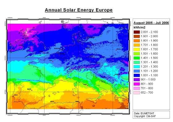
Figure B.3.1a. Map of calculated solar energy in a typical year.
Source: CM-SAF lead by DWD.
New research initiatives
High quality, high-resolution data products from EURO4M will provide the information basis for new generations of research initiatives (e.g. initialization and evaluation of Earth System Models, climate change detection and attribution studies) and wider societal, industrial and environmental user applications (e.g. climate risk, impact assessment, study of socio-economic effects of extreme climate events, reducing loss of life and property from disasters, managing the consequences of climate change, development of integrated management strategies).
EURO4M will provide a vital stimulus for the next generation of reanalyses, including those extending further back in time. Analyses of observations used in existing reanalysis products, and those that could have been used, will highlight what can be achieved if all available observations are improved and used where possible.
These new research initiatives fully comply with the recommendations for future EU integrated climate research resulting from the IPCC-AR4, which have been discussed at the international symposium “Future climate, impacts and responses” organised by the European Commission, Research Directorate-General in Brussels, 19-20 November 2007.
B.3.2 Plan for the use and dissemination of foreground
Dissemination and/or exploitation plans
EURO4M provides an exciting and unique opportunity to bring together existing meteorological services, universities, research institutions and programs in order to provide a seamless integration of climate change data and information flows and feedbacks. The proposed Climate Indicator Bulletins (CIBs; see WP3.1) and Climate Liaison Team (CLT; see WP3.2) will provide a framework for a new generation of flexible products that foster better dialogue between data providers and data users, and integration of end-user requirements for environmental and societal applications.
The effective dissemination strategy includes the identification of the target audience at regional and global levels by the CLT. An analysis of relevant interested stakeholders will be carried out and a list of all other relevant stakeholders will be produced. Then the most suitable communications programs and products (meetings, conferences, seminars, workshops, publications, brochures and leaflets) will be identified and a timeframe will be defined for their delivery, as specified in WP3. In particular, the CIBs will be used to demonstrate the project outcomes to all participating and interested stakeholders. All project activities, related documents and results, published materials (including training materials and reports) and events announcements will be regularly posted on the project website.
The knowledge and expertise developed in the project will be passed on to the young scientists and engineers in training through university professors involved who teach at their institutions and supervise PhD and graduate students. Chances will be provided for young scientists to be integrated into, and gain experience in, high level European research and international collaboration. National workshops will facilitate dialogue between the scientific institutes involved and representatives of operational sectors.
Specific communication activities, targeted at the general public, schools and the press, will be developed in order to stimulate interest in youth audiences, to attract future scientists in the broad fields of geo-sciences, and to increase public awareness about climate change and the risks of extreme weather events, leading to a better integration of these risks in the policies and programs of operational sectors. In addition, communication activities will also address educational outreach to the public with respect to basic knowledge about climate change.
Data storage and dissemination[Author ID1: at Sun Oct 25 11:59:00 2009 ]
A huge amount of observational and reanalysis data will be produced in WP1 and WP2.[Author ID1: at Sun Oct 25 11:59:00 2009 ] [Author ID1: at Sun Oct 25 12:02:00 2009 ]The raw data from EURO4M will be distributed mainly through existing systems, which can be accessed from a dedicated EURO4M web-based data portal.[Author ID1: at Sun Oct 25 12:02:00 2009 ] These data will be analysed within the project and used for the multi-purpose products developed in WP3. WP3 will make an inventory of raw data needs by users outside the project as part of the CLT activities.[Author ID1: at Sun Oct 25 11:59:00 2009 ] [Author ID1: at Sun Oct 25 11:59:00 2009 ]We anticipate the need for EURO4M data after the end of the project. Therefore, the main datasets[Author ID1: at Sun Oct 25 11:59:00 2009 ] (and the web[Author ID1: at Tue Oct 27 12:38:00 2009 ]-[Author ID1: at Tue Oct 27 12:39:00 2009 ]based data[Author ID1: at Tue Oct 27 12:38:00 2009 ] portal)[Author ID1: at Tue Oct 27 12:39:00 2009 ] will be secured for at least 5 yr after the project ends. This is possible [Author ID1: at Sun Oct 25 11:59:00 2009 ]with the[Author ID1: at Sun Oct 25 11:59:00 2009 ] allocated [Author ID1: at Sun Oct 25 11:59:00 2009 ]resources only by virtue of exploiting existing infrastructure to the full, and[Author ID1: at Sun Oct 25 11:59:00 2009 ] capitalising on the benefits associated with an adherence to standards and interoperability[Author ID1: at Sun Oct 25 11:59:00 2009 ].[Author ID1: at Sun Oct 25 11:59:00 2009 ][Author ID1: at Sun Oct 25 11:59:00 2009 ]
Educational links and capacity building
EURO4M will foster better integration of research laboratories and operational meteorological agencies in education programs. The project will catalyse a program of visiting scientists and postdoctoral positions through existing institutions. Emphasis will focus on fostering interactions between existing, new, Accession and Candidate EU States and neighbouring countries.
In order to promote common approaches and develop consensus best practice for climate data, a series of workshops will be organised, and specialised collaborations will be sponsored on specific topics of relevance to the project. The CM-SAF at DWD has already established a training group, which is operating in an international network in cooperation with EUMETSAT. The involvement of universities in the consortium means that the EURO4M approach and data products will be incorporated in existing earth system education programs. EURO4M funding will support Masters, PhD and post-doctoral fellowships at some of the participant institutions.
The consortium will also engender access to developing countries, which will be amongst the largest potential beneficiaries of international co-operation in earth observation. The latter will be done through liaising with the series of worldwide workshops (Peterson and Manton, 2008; see also Klein Tank et al., 2006) organised by the joint Expert Team on Climate Change Detection and Indices (ETCCDI) of the CCL, CLIVAR and JCOMM (Peterson et al., 2001). The EURO4M Coordinator is currently also co-chair of this Expert Team. This will complement the GMES activities in the field of capacity building as discussed at the Lisbon meeting in December 2007 and contributes to the Nairobi work programme on impacts, vulnerability and adaptation to climate change of the UNFCCC. In addition, outreach activities on data rescue, preservation, digitization and homogenization techniques and procedures programmed jointly with the WMO MEDARE Initiative will also contribute to capacity building on these subjects in developing countries and Least Developed Countries.
Contribution to standards
The formation of the EURO4M consortium responds directly to the Commission's recommendations to mobilise all European resources through coordinating and networking efforts in Research and Technical Development areas related to climate change and environmental monitoring.
EURO4M will link EU and international system outputs, capitalising on the benefits associated with an adherence to standards (e.g. Open GIS Consortium developments, ISO19100 series, Geographical Markup Language), interoperability (e.g. within INSPIRE and the WMO Information System (WIS)) and consolidation (see Section B.2.4).[Author ID1: at Sun Oct 25 12:03:00 2009 ]
Data sharing within EURO4M will follow a[Author ID1: at Sun Oct 25 12:04:00 2009 ] service-oriented approach [Author ID1: at Sun Oct 25 12:04:00 2009 ]adopting [Author ID1: at Sun Oct 25 12:04:00 2009 ]common standards on metadata, data models, and network services[Author ID1: at Sun Oct 25 12:04:00 2009 ] as described by INSPIRE and the GEOSS Architecture and Data Committee. [Author ID1: at Sun Oct 25 12:04:00 2009 ]MO[Author ID1: at Sun Oct 25 12:04:00 2009 ] leads the special group within EUMETNET called INSPIMET, which looks after the implementation rules of INSPIRE for meteorological and climatological data and services. Following these rules will ensure [Author ID1: at Sun Oct 25 12:04:00 2009 ]global connectivity and interoperability, also providing appropriate l[Author ID1: at Sun Oct 25 12:04:00 2009 ]inks to the WMO Information System (WIS). [Author ID1: at Sun Oct 25 12:04:00 2009 ]The INSPIRE-compliant infrastructure w[Author ID1: at Sun Oct 25 12:04:00 2009 ]ill enable considerable data-sharing efficiencies to be realised between EURO4M and the various GMES services requiring access to climate-related data[Author ID1: at Sun Oct 25 12:04:00 2009 ].[Author ID1: at Sun Oct 25 12:04:00 2009 ] [Author ID1: at Sun Oct 25 12:04:00 2009 ]WP3 will describe the infrastructure that is used for the datasets produced in EURO4M.[Author ID1: at Sun Oct 25 12:04:00 2009 ]
Contribution to policy development
Long-term and reliable climate data are vital for detecting, understanding, predicting and responding to climate change and variability. The development of increasingly sophisticated climate models has reinforced the need for basic observations. However, as the demand for objective information grows, GEO and GCOS have indicated that our capacity to monitor climate and environmental changes and fluctuations is still largely inadequate.
Monitoring climate change and extremes at the multi-decadal and century time scale is currently not among the core GMES services. Ongoing activities in the GEO work plan also do not cover long-term climate observations and monitoring, even though GEO is a strong advocate for sustained and coordinated climate observing systems. EURO4M is positioned to form the implementation component of the atmospheric sections of GCOS and GEOSS. By taking on the climate section of the plan EURO4M will coordinate a monitoring framework essential for the success of GEOSS.
EURO4M is crucial for establishing the climate change component of GMES and thus for the European contribution to the development and integration of the GEOSS. A key system for climate change observations and information will be provided for the benefit of each of the nine societal benefit areas of GEO. The system integrates European climate change monitoring activities into the global picture. In this way, the project will contribute to forward European and international efforts in strategic policy areas, such as climate change and energy. Involvement of international partnerships will ensure proper know-how is taken into account, as well as avoiding duplication of efforts. This will enable Europe to play a pivotal role in the systematic monitoring of climate mandated by the UNFCCC.
EURO4M will form a core component of the European implementation of the atmospheric climate component of GCOS in support of the UNFCCC. The Implementation Plan for GCOS addresses the requirements identified in the Second Report on the Adequacy of the GCOS (GCOS, 2003), in particular the ECVs and associated climate products defined in the report. In summer 2009, Parties to the UNFCCC endorsed the main findings of the recently issued “Progress Report on the Implementation of the Global Observing System for Climate in Support of the UNFCCC 2004-2008” (GCOS, 2009) in their conclusions at SBSTA 30, as well as in a draft decision, for consideration at COP 15 in Copenhagen in December 2009. This encourages Parties to strengthen their efforts to address the priorities identified.
Finally, within the context of the Kyoto Protocol, EURO4M will directly focus on the following Articles: 9.1) Provide the best available scientific information and assessment on climate change and its impacts; 10.c) Promote education and training, and increase public awareness of climate change; 10.d) Participate and co-operate in international scientific research programmes to reduce uncertainties related to the climate system and the adverse impacts of climate change.
Added-value in carrying out the work at a European level
EURO4M will only work when carried out at the European level, building on existing national monitoring capacity and atmospheric observation programs to form a truly European integrated system capable of providing CIBs on extreme events that threaten Europe, and its citizens and interests worldwide. The development of such a system requires an unprecedented level of collaboration and coordination of multidisciplinary research, enhancement of operational activities within the climate research and monitoring community.
Although elements of such a system presently exist, the state of their development in the different European countries is uneven. More critically, access to data, information, and products by users is in many cases inadequate and difficult.
A European-wide coordination will avoid unnecessary duplication and hence enable resources to be focussed more effectively. This will also result in more uniform, high quality and standardised products, which will be available to all European countries, reducing the geographical disparity between countries and regions for information and services available to intermediate- and end-users. It will encourage the development of scientific research and analysis at the national level as well as at the EU level, allowing countries to make the most of the collaboration both in terms of data resources and R&D expertise. As a side-effect, improved access to products and services will encourage smaller nations to make a greater contribution to existing observation networks.
The enlargement of the European Union in 2004 gives the opportunity to enlarge the scientific co-operation. In fact, co-operation with East and Southeast European countries is essential to tackle topics in environmental research with a wider regional dimension such as climatic change and variability. The European scale ensures that sufficient resources are mobilised to address the goal and objectives of the work program and maintain pre-eminence within the international community.
Account taken of other national or international research activities
EURO4M is designed to build on existing capacity. As described in Section B.1.1, the project fully benefits from ongoing national and international work on observational datasets and data assimilation. EURO4M will link very strongly to the wider international community. GMES cannot be successfully implemented without exchanging equivalent observational data through cooperation schemes, thereby sharing the cost of observation infrastructure with non-EU partners (EC, 2008).
EURO4M beneficiaries include members of the GEO Committees, GCOS Steering Committee, its Atmospheric Observation Panel for Climate (AOPC) and Oceanic Observation Panel for Climate (OOPC) specialist groups, WMO Open Programme Area Groups (OPAGs) and Expert Teams (some of them also lead by EURO4M beneficiaries), International research programme on Climate Variability and Predictability (CLIVAR) Expert Teams, the WCRP Observations and Assimilation Panel and the WCRP WG on Observational Data Sets for Reanalyses. EURO4M beneficiaries are also intimately involved in IPCC activities.
EURO4M will work with its international partners to collate and report on ECVs, including integrating existing data products and providing uncertainty estimates for each ECV. EURO4M will link with WMO programmes and improve the reporting of observations to international data centres. EURO4M fits perfectly in the WCRP strategy for Coordinated Observation and Prediction of the Earth System (COPES; WMO, 2005).
Links to ongoing FP projects
EURO4M links to ongoing FP6 and FP7 projects, including those developing prototype and pre-operational GMES services (such as GEOLAND2, MyOcean, MACC), and other related FP projects (such as ENSEMBLES, EURO-LIMPACS, CECILIA, CIRCE, etc.):
EURO4M will complement GEOLAND2, which joins a range of previous GMES projects to deliver a range of geo-information services for the terrestrial sphere, and MyOcean, which will define and set up a concerted and integrated pan-European capacity for ocean monitoring and forecasting. EURO4M partners involved in GEOLAND2 and MyOcean will link the project results to these services.
They both require the long-term climate change monitoring information that EURO4M will deliver (in particular on extremes) as an input.Strong ties also exist with the MACC consortium lead by ECMWF. MACC (Monitoring Atmospheric Composition and Climate) combines the earlier projects PROMOTE and GEMS, which provide prototype atmospheric services for GMES. PROMOTE (PROtocol MOniToring for the GMES Service Element: Atmosphere) focuses on stratospheric ozone depletion, surface UV exposure, air quality, whereas GEMS (Global and regional Earth-system Atmosphere Monitoring using Satellite and in situ data) focuses on global distributions of atmospheric constituents important for climate. Although responsible for the pre-operational atmospheric services from 2009 onwards, MACC does not include the longer (multi-decadal) time scales and many of the ECVs required for climate change monitoring that EURO4M will address.
EURO4M will build on the high-resolution gridded observational datasets for Europe developed in ENSEMBLES and work towards getting these datasets into an operational status. Our user-oriented work will benefit from collaboration with the EURO-LIMPACS (Integrated project to evaluate impacts of global change on European freshwater ecosystems) team, designed to assess the effects of future global change on Europe's freshwater ecosystems, as well as from CIRCE and CECILIA for collection and homogenisation of long daily temperature and precipitation data for all the Mediterranean countries and Eastern Europe.
The work on extremes in WP3 will be performed through strong connections with the EU projects ENSEMBLES, CIRCE and CLARIS-LPB (A Europe-South America Network for Climate Change Assessment and Impact Studies). The work on extremes will also build on the results of earlier EU FP5 projects, like STARDEX, MICE (Modelling the Impact of Climate Extremes), EMULATE and ALP-IMP (Multi-centennial climate variability in the Alps based on Instrumental data, Model simulations and Proxy data), plus recent global initiatives from IPCC which many EURO4M beneficiaries have been actively involved with.
A clear link also exists with the global reanalyses proposal to EU FP7 ENV, which is in preparation by a consortium led by ECMWF. EURO4M is designed to be complementary to global reanalysis efforts, by concentrating on aspects where it can add value, such as a higher horizontal resolution (the global reanalysis proposal will likely suggest a 40km resolution), the assimilation of surface precipitation data, and delivering integrated products at the required level of aggregation and processing to respond to a wide range of users and downstream services.
Links to other activities
In an effort to further harmonize European climate change information, EURO4M will connect to the European Co-operation in the field of Scientific and Technical Research (COST-) Action ES0601 (HOME) on comparisons of methods for homogenisation of long instrumental climate records. New quality control and homogeneity testing of early instrumental observations, particularly from EU Accession and Candidate States and neighbouring countries will build on the data products generated by EU-funded and other projects, such as ECA&D, NORDKLIM (Nordic co-operation within climate activities), EuroClim (European Climate Change Monitoring and Prediction System), MedCLIVAR (Mediterranean CLIVAR) and CLIWOC (Climate of the world's oceans), integrating these data with the holdings of a suite of international databases.
EURO4M will work with International Comprehensive Ocean-Atmosphere Dataset (ICOADS) initiatives to aid the digitisation of many millions of historical marine data in European archives being funded separately under projects such as ACRE. EURO4M will link via ACRE to the 20th Century Reanalysis Project and other longer historical reanalyses. With these reanalysis products, there are also the full linkages and “end-to-end” infrastructure which ACRE integrates in working with climate applications users.
EURO4M has already linked with the EUMETSAT-SAFs, in particular to assess user community needs and to contribute to the development of integrated products. The coordinator (at DWD) of the CM-SAF is participating in EURO4M.
EURO4M also links to MEDARE activities on data rescue and surface climate reconstruction for the GMR (under the umbrella of WMO; see Brunet and Kuglitsch, 2008), EUMETNET-ECSN for the remainder of Europe and EuroCryoClim for the Arctic. We will liaise with other recent initiatives for particular sub-regions such as the Alps and the Baltic Sea region. Examples are the project MOnitoring Climate variability and Change for an improved environmental and risk management in the Alpine space (MOCCA) and the Baltic Sea Experiment (BALTEX). The latter will seek to exploit and analyze the results of EURO4M to quantify the water and energy budgets over the Baltic Sea basin and evaluate and improve regional climate models. The good results in the spatialization tools for complex terrain achieved in the EUMETNET-ECSN HRT-GAR project constructing a High resolution Temperature Climatology for the Greater Alpine Region will also be taken into account. These kinds of products are useful to fill the existing gap between the present day observation datasets for Europe and what end users really need in terms of spatial resolution to support impact evaluation.
R[Author ID1: at Sun Oct 25 12:09:00 2009
]isk[Author ID1: at Sun Oct 25 12:09:00 2009
] assessment and related communication strategy[Author ID1: at Sun Oct 25 12:09:00 2009
][Author ID1: at Sun Oct 25 12:09:00 2009
]
For the successful implementation of the EURO4M aims we rely partly on the cooperation and responsiveness of data holding institutions which are not participating. Overall, we are confident that we can achieve our objectives, as the interest in this project from the community of national responsible institutions and their organisations is very high. [Author ID1: at Sun Oct 25 12:09:00 2009
]The links to third party participants already established (in particular EEA, ECMWF and EUMETNET; see Section [Author ID1: at Sun Oct 25 12:09:00 2009
]B.[Author ID1: at Sun Oct 25 12:09:00 2009
]2.3) will help to solve any potential risk[Author ID1: at Sun Oct 25 12:09:00 2009
].[Author ID0: at Thu Nov 30 00:00:00 1899
]
One of these risks is a[Author ID1: at Sun Oct 25 12:09:00 2009
]ccess to[Author ID1: at Sun Oct 25 12:09:00 2009
] weather and climate d[Author ID1: at Sun Oct 25 12:09:00 2009
]ata[Author ID1: at Sun Oct 25 12:09:00 2009
], which[Author ID1: at Sun Oct 25 12:09:00 2009
] is often restricted due to intellectual property rights[Author ID1: at Sun Oct 25 12:09:00 2009
] (see Data exchange)[Author ID1: at Sun Oct 25 12:09:00 2009
]. This[Author ID1: at Sun Oct 25 12:09:00 2009
] also[Author ID1: at Sun Oct 25 12:09:00 2009
] affects the results of[Author ID1: at Sun Oct 25 12:09:00 2009
] earlier EU research projects[Author ID1: at Sun Oct 25 12:09:00 2009
]. [Author ID1: at Sun Oct 25 12:09:00 2009
]As a result, m[Author ID1: at Sun Oct 25 12:09:00 2009
]ajor costs may arise from access to meteorological data[Author ID1: at Sun Oct 25 12:09:00 2009
]. The fact that the consortium as a whole represents key climate change data holding institutions in Europe and the fact that the consortium members have been active in most of the related EU research projects in the past places us in the best possible position to overcome this problem. In case data policy restrictions hamper the work, the Coordinator will bring the issue to the responsible parties, including the EUMETNET Council.[Author ID0: at Thu Nov 30 00:00:00 1899
]
In the case that internal disputes will occur during the course of the project, we will begin at the source of the dispute and expand outwards until an equitable solution has been reached. The participant tries to settle the dispute with its respective WP-leader. If not successful, the Management Board (MB; see Section [Author ID1: at Sun Oct 25 12:09:00 2009
]B.[Author ID1: at Sun Oct 25 12:09:00 2009
]2.1) will develop a strategy and intervene to settle the dispute with the possibility of sanctions. In case of disagreement within the MB, the Coordinator will take the final decision and he will be responsible for its execution. The Coordinator will report the case and its solution or consequences to the EC appointed project officer.[Author ID1: at Sun Oct 25 12:09:00 2009
]
B.4 Ethical issues
The beneficiaries in this project declare that there are no ethical issues relevant to this proposal. Nevertheless, the Coordinator and MB will continue to keep this aspect under review, and should any such issues arise in the future, they will be addressed and taken into account in due time.
B.5 Consideration of gender aspects
Gender Action plan
Many of the beneficiaries in EURO4M have gender action plans at the institutional level as part of their commitment to gender equality. These include programmes to raise awareness of the issues involved in gender equality, commitments to family friendly work practices and career breaks, and provision of child-care facilities. Organisational initiatives to encourage gender equality enjoy high level backing within many partner institutes. For example, KNMI is a participant in the Dutch GAIA-network and as such actively involved in the EU EQUAL-II Priority for Participation project. MO have an ongoing equality training programme, coordinated at boardroom level, which is mandatory for all staff. For beneficiaries based at institutions with less detailed plans, the Gender Action plan in EURO4M will provide an important impulse.
One of the four WP-leaders of EURO4M is a woman, as are 2 of the lead scientists at the 9 participating institutes.
Project Gender Committee: The gender committee will actively promote the role of women at all levels within the project. It will be responsible for ensuring that the gender action plan is applied across the spectrum of WPs in the project, both in terms of internal communication of developments and progress via the project website, and communicating progress externally, via the annual gender action report. The committee will also be responsible for ensuring that the training and dissemination aspects of the project are female-friendly. The committee will consist of 3 members elected by all project beneficiaries on an annual basis, with the possibility of re-election.
Annual Gender Action Report: The report will document the extent to which actions promoting gender equality have been performed at the project level, and will chart the rates of female participation at all levels of the project.
Recruitment of Female Researchers: Recruitment of young, talented female researchers will be encouraged in EURO4M. Job advertisements will state the project's commitment to equality and to a family-friendly working environment and will explicitly encourage women to apply. The gender committee will liaise with national programmes in the production of suitable information material for schools.
Consortium Agreement: The Consortium Agreement governing the operation of the project will enforce the following minimum requirements on the participating institutions:
encouragement of applications by female researchers in job advertisement;
formal action to ensure that employees are properly informed about their parental rights and responsibilities;
encouragement of female coaching and mentoring schemes, and project management;
production of an annual report on the nature and utility/success of gender actions undertaken;
Management Board: The Management Board has been chosen to ensure that women are adequately represented at the highest organisational levels of the project and consists of seven people. From the four appointed, one is woman (25%). Whilst not approaching equality, this percentage is higher than that of women in senior positions in climate science generally, and gives women a significant say in how the project is organised and run.
References
Aguilar E., I. Auer, M. Brunet, T.C. Peterson, J. Wieringa, 2003: Guidelines on climate metadata and homogenization. WCDMP-No. 53, WMO-TD No. 1186. World Meteorological Organization, Geneva.
Aguilar, E., T.C. Peterson, P. Ramirez Obando, R. Frutos, J.A. Retana, M. Solera, J. Soley,
I. Gonzalez Garcia, R.M. Araujo, A. Rosa Santos, V.E. Valle, M. Brunet, L. Aguilar, L. Alvarez, M. Bautista, C. Castañon, L. Herrera, E. Ruano, J.J. Sinay, E. Sanchez, G.I. Hernandez Oviedo, F. Obed, J.E. Salgado, J.L. Vazquez, M. Baca, M. Gutierrez, C. Centella, J. Espinosa, D. Martinez, B. Olmedo, C.E. Ojeda Espinoza, R. Nuñez, M. Haylock, H. Benavides, and
R. Mayorga, 2005: Changes in precipitation and temperature extremes in Central America and Northern South America. J. Geophys. Res., 110, D23107, DOI 10.1029/200.
Aguilar, E., A. Barry, M. Brunet, L. Ekang, A. Fernandes, M. Massoukina, J. Mbah, A. Mhanda, D.J. do Nascimento, T.C. Peterson, O. Thamba, M. Tomou, X. Zhang, 2008: Changes in temperature and precipitation extremes in Western Central Africa, Guinea Conakry and Zimbabwe, 1955-2006. J. Geophys. Res. (in press).
Alexander, L.V., X. Zhang, T.C. Peterson, J. Caesar, G. Gleason, A. Klein Tank, M. Haylock,
D. Collins, B. Trewin, F. Rahimzadeh, A. Tagipour, P. Ambenje, K. Rupa Kumar,
J. Revadekar, G. Griffiths, L. Vincent, D. Stephenson, J. Burn, E. Aguilar, M. Brunet,
M. Taylor, M. New, P. Zhai, M. Rusticucci, J.L. Vazquez-Aguirre, 2006: Global observed changes in daily climate extremes of temperature and precipitation. J. Geophys. Res., 111, D05109, doi:10.1029/2005JD006290.
Alexandersson, H., et al., 2000: Trends of storms in NW Europe derived from an updated pressure data set. Clim. Res., 14, 71-73.
Allan, R.J. and T.J. Ansell, 2006: A new globally complete monthly historical gridded mean sea level pressure dataset (HadSLP2): 1850-2004. J. Climate, 19, 5816-5842.
Ansell, T., et al., 2006: Daily mean sea level pressure reconstructions for the European - North Atlantic region for the period 1850-2003. J. Climate, 19, 2717-2742.
Auer I., et al., 2005: A new instrumental precipitation dataset in the greater alpine region for the period 1800-2002. Int. J. Climatol., 25, 139-166.
Babst, F., R.W. Mueller, R. Hollmann, 2008: Verification of NCEP reanalysis shortwave radiation with mesoscale remote sensing data. Geosciences and Remote Sensing Letters, 5, 34-37.
Bauer, P. and P. Schluessel, 1993: Rainfall, total water, ice water, and water vapour over sea from polarized microwave simulations and special sensor microwave/imager data., J. Geophys. Res., 98, 20737-20759.
Beck, C., J. Grieser and B. Rudolf, 2005: A new monthly precipitation climatology for the global land areas for the period 1951 to 2000. Klimastatusbericht 2004, DWD , ISSN 1437-7691, ISSN 1616-5063 (Internet), ISBN 3-88148-402-7, 181-190.
Beyer, H.G., C. Costanzo, and D. Heinemann, 1996: Modifications of the Heliosat procedure for irradiance estimates from satellite images. Solar Energy, 56, 207-212.
Brohan, P. et al., 2006: Uncertainty estimates in regional and global observed temperature changes. J. Geophys. Res., 111, D12106.
Brunet M., P. D. Jones, J. Sigró, O. Saladié, E. Aguilar, A. Moberg, P. M. Della-Marta, D. Lister, A. Walther, and D. López, 2007a: Temporal and spatial temperature variability and change over Spain during 1850-2005. J. Geophys. Res., 112, D12117, doi:10.1029/2006JD008249.
Brunet M., J. Sigró, P.D. Jones, O. Saladié, E. Aguilar, A. Moberg, D. Lister and A. Walther, 2007b: Long-term changes in extreme temperatures and precipitation in Spain, Contributions to Science, 3, Barcelona, 331-342.
Brunet, M., O. Saladié, P. Jones, J. Sigró, E. Aguilar, A. Moberg, D. Lister, A. Walther, and
C. Almarza, 2008: A case-study/Guidance on the development of long-term daily adjusted temperature datasets. WMO-TD-1425 - WCDMP-66, Geneva: 43 pp.
Brunet, M. and F. G. Kuglitsch (Eds.), 2008: Proceedings of the International Workshop on Rescue and Digitization of Climate Records in the Mediterranean Basin, WCDMP No. 67/WMO-TD No. 1432, XXII + 219 pp.
Butler, D., 2007: The planetary panopticon. Nature, 450, 778-781.
Deneke, H.M., A.J. Feijt, and R.A. Roebeling, 2008: Estimating surface solar irradiance from METEOSAT SEVIRI-derived cloud properties. Remote Sens. Environ., 112, 3131-3141.
Drews, A., H.G. Beyer and U. Rindelhardt, 2008: Quality of performance assessment of PV plants based on irradiance maps. Solar Energy, 82, 1067-1075, doi:10.1016/j.solener.2008.04.009
Dürr, B. and A. Zelenka, 2008: Deriving surface global irradiance over the Alpine region from METEOSAT Second Generation data by supplementing the HELIOSAT method. International Journal of Remote Sensing (in press).
Dürr, B., A. Zelenka, R. Müller and R. Philipona, 2008: Verification of CM-SAF and MeteoSwiss satellite based retrievals of surface shortwave irradiance over the Alpine region. International Journal of Remote Sensing (accepted).
Durand, Y., M. Laternser, G. Giraud, P. Etchevers, B. Lesaffre, and L. Mérindol, 2008: Reanalysis of 44 years of climate in French Alps (1958-2002); methodology, model validation, climatology and trends for air temperature and precipitation. J. of App. Met. and Clim. Doi:10.1175/2008JAMC1808.1 (submitted).
Durre, I., R.S. Vose, and D.B. Wuertz, 2006: Overview of the integrated global radiosonde archive. J. Climate., 19, 53-68.
EC, 2008: Global Monitoring for Environment and Security (GMES): we care for a safer planet. Communication from the Commission to the European Parliament, the Council, the European Economic and Social Committee and the Committee of the Regions. COM(2008) 748 final.
EEA-JRC-WHO, 2008: Impacts of Europe's changing climate - 2008 indicator-based assessment. EEA Report No 4/2008, JRC Reference Report No JRC47756, DOI 10.2800/48117.
Fortelius, C., A. Andrae, and M. Forsblomi, 2002: The BALTEX regional reanalysis project. Boreal Env. Res., 7, 193-201.
Frei, C. and C. Schär, 1998: A precipitation climatology of the Alps from high-resolution rain-gauge observations. Int. J. Climatol., 18, 873-900.
GCOS, 2003: GCOS Second Report on the Adequacy of the Global Climate Observing System in Support of the UNFCC. GCOS-92, WMO/TD No. 1143, 75pp.
GCOS, 2004: GCOS Implementation Plan for Global Observing System for Climate in support of UNFCC. GCOS-92, WMO/TD No. 1219, 136 pp.
GCOS, 2009: Progress Report on the Implementation of the Global Observing System for Climate in Support of the UNFCCC 2004-2008. GCOS-129, WMO/TD No. 1489, 106 pp.
GEO, 2007: GEO Group on Earth Observations Work Plan for 2007-2009. March 2007. 37pp., www.earthobservations.org/documents/wp0709_v4.pdf
Grassl, H., V. Jost, R. Kumar, J. Schulz, P. Bauer, P. Schluessel, 2000: The Hamburg Ocean-Atmosphere Parameters and Fluxes from Satellite Data (HOAPS): A Climatological Atlas of Satellite-Derived Air-Sea-Interaction Parameters over the Oceans., Report No. 312, ISSN 0937-1060, Max Planck Institute for Meteorology, Hamburg.
Gustafsson, N., L. Berre, S. Hörnquist, X.Y. Xuang, M. Lindskog, B. Navascues, K.S. Mogensen, and S. Thorsteinsson, 2000: Three-dimensional variational data assimilation for a limited area model, Part I: General formulation and the background error constraint. Tellus, 53A, 425-446.
Habets, F. , A. Boone, J.L. Champeaux, P. Etchevers, L. Franchisteguy, E. Leblois, E. Ledoux,
P. Le Moigne, E. Martin, S. Morel, J. Noilhan, P. Quintana Segui, F. Rousset-Regimbeau and P. Viennot, 2008: The SAFRAN-ISBA-MODCOU hydrometeorological model applied over France. J. Geophys. Res., 113, D06113,doi:10.1029/2007JD008548.
Haimberger, L., 2005: Homogenization of radiosonde temperature time series using ERA-40 analysis feedback information. ERA-40 Project Report Series 23, ECMWF, Reading, U.K.,
68 pp.
Haimberger, L., C. Tavolato, and S. Sperka, 2008: Toward elimination of the warm bias in historic radiosonde temperature records - Some new results from a comprehensive intercomparison of upper-air data. J. Climate, 21, 4587-4606, DOI: 10.1175/2008JCLI1929.1.
Hammer, A., D. Heinemann, C. Hoyer, R. Kuhlemann, E. Lorenz, R.W. Müller, H.G. Beyer, 2003: Solar energy assessment using remote sensing technologies. Remote Sensing of Environment, 86, 423-432.
Haylock, M.R., N. Hofstra, A.M.G. Klein Tank, E.J. Klok, P.D. Jones, M. New, 2008: A European daily high-resolution gridded dataset of surface temperature and precipitation. J. Geophys. Res., 113, doi:10.1029/2008JD10201.
Hofstra, N. M. Haylock, M. New, P. Jones, and C. Frei, 2008: Comparison of six methods for the interpolation of daily, European climate data. J. Geophys. Res., 113, doi:10.1029/2008JD010100.
Jansson, A., C. Persson, and G. Strandberg, 2007: 2D meso-scale re-analysis of precipitation, temperature and wind over Europe - ERAMESAN. Time period 1980-2004. SMHI, RMK Report No 112.
Jenkins, G.J., M.C. Perry, and M.J.o. Prior, 2007: The climate of the United Kingdom and recent trends. Met Office Hadley Centre, Exeter, UK.
Kabat, P. and P. Velinga, 2005: Climate proofing the Netherlands. Nature, 438, 283-284.
Klein Tank, A.M.G., T.C. Peterson, D.A. Quadir, S. Dorji, X. Zou, H. Tang, K. Santhosh, U.R. Joshi, A.K. Jaswal, R.K. Kolli, A. Sikder, N.R. Deshpande, J.V. Revadekar, K. Yeleuova, S. Vandasheva, M. Faleyeva, P. Gomboluudev, K.P. Budhathoki, A. Hussain, M. Afzaal, L. Chandrapala, H. Anvar, D. Amanmurad, V.S. Asanova, P.D. Jones, M.G. New, T. Spektorman, 2006: Changes in daily temperature and precipitation extremes in central and south Asia. J. Geophys. Res., 111 (D16105), doi:10.1029/2005JD006316.
Li, J., W.W. Wolf, W.P. Menzel, W. Zhang, H.-L. Huang, and T.H. Achtor, 2000: Global soundings of the atmosphere from ATOVS measurements: The algorithm and validation.
J. Appl. Meteor., 39, 1248-1268.
Lindskog, M., N. Gustafsson, B. Navascués, K.S. Mogensen, X.-Y. Huang, X. Yang, U. Andrae,
L. Berre, S. Thorsteinsson, and J. Rantakokko, 2001: Three-dimensional variational data assimilation for a limited area model. Part II: Observation handling and assimilation experiments. Tellus, 53A, 447-468.
Mesinger, F., et al., 2006: North American Regional Reanalysis. BAMS, DOI:10.1175/BAMS-87-3-343.
Mitchell, T.D., and P.D. Jones, 2005: An improved method of constructing a database of monthly climate observations and associated high-resolution grids. Int. J. Climatol., 25, 693-712.
Moberg, A., P. D. Jones, D. Lister, A. Walther, M. Brunet, J. Jacobeit, L. V. Alexander, P. M. Della-Marta, J. Luterbacher, P. Yiou, D. Chen, A. M. G. Klein Tank, O. Saladié, J. Sigró, E. Aguilar, H. Alexandersson, C. Almarza, I. Auer, M. Barriendos, M. Begert, H. Bergström, R. Böhm, C. J. Butler, J. Caesar, A. Drebs, D. Founda, F. W. Gerstengarbe, G. Micela, M. Maugeri, H. Österle, K. Pandzic, M. Petrakis, L. Srnec, R. Tolasz, H. Tuomenvirta, P. C. Werner, H. Linderholm, A. Philipp, H. Wanner, and E. Xoplaki, 2006: Indices for daily temperature and precipitation extremes in Europe analysed for the period 1901-2000. J. Geophys. Res., 111 (D22106), doi:10.1029/2006JD007103.
Navascuès, B., 1997: Analysis of 2 meter Temperature and Relative Humidity. HIRLAM Tech. Report No. 28, S-601 76, SMHI, Norrköping, SWEDEN.
Parker, D.E., 2004: Large scale warming is not urban. Nature, 432, 290.
Peterson, T. C., et al., 2001: Report on the activities of the Working Group on Climate Change Detection and Related Rapporteurs 1998-2001. World Meteorological Organisation Rep. WCDMP-47, WMO-TD 1071, Geneva, Switzerland, 143 pp.
Peterson T. C., X. Zhang, M. Brunet, and J.L. Vázquez Aguirre, 2007: Changes in North American extremes derived from daily weather data. J. Geophys. Res., doi:10.1029/2007JD009453.
Peterson, T.C., and M.J. Manton, 2008: Monitoring changes in climate extremes - A tale of international collaboration. Bull. Amer. Meteorol. Soc., DOI:10.1175/2008BAMS2501.1.
Rayner, N.A., et al., 2006: Improved analyses of changes and uncertainties in marine temperature measured in situ since the mid-nineteenth century: the HadSST2 dataset.
J. Climate, 19, 446-469.
Rodríguez E., B. Navascuès, J.J. Ayuoso, and S. Järvenoja, 2003: Analysis of surface variables and parameterization of surface processes in HIRLAM. Part 1: Approach and verification by parallel runs. HIRLAM Tech. Report No. 58, S-601 76, SMHI, Norrköping, SWEDEN.
Roebeling, R.A., A.J. Feijt, and P. Stammes, 2006: Cloud property retrievals for climate monitoring: implications of differences between SEVIRI on METEOSAT-8 and AVHRR on NOAA-17. J. Geophys. Res., 111, D20210, doi:10.1029/2005JD006990.
Roebeling, R.A. and I. Holleman, 2008: Validation of rain rate estimates from SEVIRI using weather radar observations, Proceedings EUMETSAT Meteorological Satellite Conference,
8 - 12 September 2008, Darmstadt, Germany.
Rudolf, B., and U. Schneider, 2005: Calculation of Gridded Precipitation Data for the Global Land-Surface using in situ Gauge Observations. Proceedings of the 2nd Workshop of the International Precipitation Working Group IPWG, Monterey October 2004, EUMETSAT, ISBN 92-9110-070-6, ISSN 1727-432X, 231-247.
Schulz, J, P. Albert, H.-D. Behr, D. Caprion, H. Deneke, S. Dewitte, B. Duerr,P. Fuchs, A. Gratzki, P. Hechler, R. Hollmann, S. Johnston, K.-G. Karlsson,T. Manninen, R. Müller, M. Reuter, A. Riihel¨a, R. Roebeling, N. Selbach, A. Tetzlaff, W. Thomas, M. Werscheck, E. Wolters, and A. Zelenka, 2008: Operational climate monitoring from space: the EUMETSAT satellite application facility on climate monitoring (CM-SAF), Atmos. Chem. Phys. Discuss., 8, 8517-8563.
Simmons, A.J., P.D. Jones, V. da Costa Bechtold, A.C.M. Beljaars, P.W. Kållberg, S. Saarinen, S.M. Uppala, P. Viterbo and N. Wedi, 2004: Comparison of trends and low-frequency variability in CRU, ERA-40 and NCEP/NCAR analyses of surface air temperature. J. Geophys. Res., 109, D24115, doi:10.1029/2004JD006306.
Thorne, P.W., et al., 2005a: Revisiting radiosonde upper-air temperatures from 1958 to 2002.
J. Geophys. Res., 110, D18105, doi:10.1029/2004JD00575.
Thorne, P.W., Parker, D.E., Christy, J.R. and Mears, C.A., 2005b: Uncertainties in climate trends: lessons from upper-air temperature records. Bull. Amer. Meteorol. Soc., 86, 1437-1442.
Titchner, H., M.P. McCarthy, P.W. Thorne, S.F.B. Tett, L. Haimberger, and D.E. Parker, 2008: Critically reassessing tropospheric temperature trends from radiosondes using realistic validation experiments. J. Climate (in press).
Trentmann, J. and R.W. Mueller, et al., 2008: Evaluation of ERA-interim downwelling surface radiation fluxes with BSRN surface observations, DWD (manuscript in preparation).
Undén, P., L. Rontu, H. Järvinen, P. Lynch, J. Calvo, G. Cats, J. Cuxart, K. Eerola, C. Fortelius,
J. Antonio Garcia-Moya, C. Jones, G. Lenderlink, A. McDonald, R. McGrath, B. Navascues,
N. Woetman Nielsen, V. Ødegaard, E. Rodriguez, M. Rummukainen, R Rõõm, K. Sattler,
B. Hansen Sass, H. Savijäarvi, B. Wichers Schreur, R. Sigg, H. The, A. Tijm, 2002: HIRLAM-5 Scientific Documentation, HIRLAM-5 Project. c/o Per Undén SMHI, S-601 76 Norrköping, SWEDEN.
Uppala, S.M., P. Kållberg, A.J. Simmons, U. Andrae, V. Da Costa Bechtold, M. Fiorino,
K. Gibson, J. Haseler, A. Hernandez., G.A. Kelly, K. Li, K. Onogi, S. Saarinen, N. Sokka,
R.P. Allan, E. Andersson, K. Arpe, M. Balmaseda, A.C.M. Beljaars, L. Van De Berg, J. Bidlot,
N. Bormann, S. Caires, F. Chevallier, A. Dethof, M. Dragosavac, M. Fisher, M. Fuentes,
S. Hagemann, E. Hólm, B.J. Hoskins, L. Isaksen, P.A.E.M. Janssen, R. Jenne, A.P. McNally, J.-F. Mahfouf, J.-J. Morcrette, N.A. Rayner, R.W. Saunders, P. Simon, A. Sterl, K.E. Trenberth, A. Untch, D. Vasiljevic, P. Viterbo, and J. Woollen, 2005: The ERA-40 reanalysis. Quart. J. Roy. Meteor. Soc., 131, 2961-3012.
Wang, L. and J.J. Qu, 2007: NMDI: A normalized multi-band drought index for monitoring soil and vegetation moisture with satellite remote sensing, Geophys. Res. Letters, 34, L20405, doi:10.1029/2007GL031021.
Wang K. and S. Liang, 2008: An improved method for estimating global evapotranspiration based on satellite determination of surface net radiation, vegetation index temperature and soil moisture. Journal of Hydrometeorology, 9, 712-727.
Wijngaard, J.B., A.M.G. Klein Tank, and G.P. Können, 2003: Homogeneity of 20th century European daily temperature and precipitation series. Int. J. Climatol, 23, 679-692.
Willett, K.M., N.P. Gillett, P.D. Jones and P.W. Thorne, 2007: Attribution of observed surface humidity changes to human influence. Nature, 449, 710-713.
Willett, K.M., P.D. Jones, N.P. Gillett and P.W. Thorne, 2008: Recent changes in surface humidity: Development of the HadCRUH dataset. J. Climate, 21, 5364-5383.
WMO, 2005: The WCRP Strategic Framework 2005-2015 Coordinated Observation and Prediction of the Earth System (COPES). WCRP-123, WMO/TD-No. 1291, August 2005,
59 pp.
Zhang, X., E. Aguilar, S. Sensoy, H. Melknyan, U. Taghiyeva, N. Ahmed, N. Kutaladze, F. Rahimzadeh, A. Taghipour, T. H. Hantosh, P. Albert, M. Semawi, M.K. Ali, M. Halal, S. Al-Shabibi, Z. Al-Oulan, T. Zatari, I. Al Dean Khalil, R. Sagir, M. Demircan, M. Eken, M. Adiguzel, L. Alexander, T.C. Peterson and T. Wallis, 2005: Trends in Middle East climate extremes indices during 1930-2003. J. Geophys. Res., 110, D22104, doi:10.1029/2005JD006181.
Appendix A: [Author ID1: at Sun Oct 25 10:37:00 2009 ]Baseline input datasets[Author ID1: at Sun Oct 25 10:38:00 2009 ][Author ID1: at Sun Oct 25 10:37:00 2009 ]
The baseline datasets which serve as an input for EURO4M are detailed in Table B.1.2b, as well as whether they are classified as Earth Observation (satellite) data. For each dataset, the table also gives the respective source and the way the consortium has access to this source (including GMES core services and/or ESA data if applicable).[Author ID1: at Sun Oct 25 10:39:00 2009 ]
Table[Author ID1: at Sun Oct 25 10:37:00 2009 ] [Author ID1: at Sun Oct 25 10:37:00 2009 ]B.1.2b[Author ID1: at Sun Oct 25 10:37:00 2009 ]. [Author ID1: at Sun Oct 25 10:37:00 2009 ]Baseline datasets used in EURO4M[Author ID1: at Sun Oct 25 10:37:00 2009 ].[Author ID1: at Sun Oct 25 10:37:00 2009 ][Author ID1: at Sun Oct 25 10:37:00 2009 ]
[Author ID1: at Sun Oct 25 10:37:00 2009 ]Appendix B[Author ID1: at Sun Oct 25 10:44:00 2009 ]: Acronym list
ACRE: Atmospheric Circulation Reconstructions over the Earth
AIREP: Air Report (aviation)
ALADIN: Limited-area NWP model
ALP-IMP: Multi-centennial climate variability in the Alps based on Instrumental data, Model simulations and Proxy data
AMDAR: Aircraft Meteorological Data Relay
AOPC: Atmospheric Observation Panel for Climate (part of GCOS)
AROME: High resolution model of Météo France
ARPEGE-IFS: atmospheric model developed jointly by Météo France and ECMWF
ATOVS: Advanced TIROS Operational Vertical Sounder
BALTEX: Baltic Sea Experiment
BSRN: Baseline Surface Radiation Network
CarboEurope: Assessment of the European Terrestrial Carbon Balance
CCl: Commission for Climatology (of WMO)
CECILIA: Central and Eastern Europe Climate Change Impact and Vulnerability Assessment (EU-project)
CIB: Climate Indicator Bulletin (part of EURO4M)
CIRCE: Climate change and impact research: the Mediterranean environment (EU-project)
CIRCLE: Climate Impact Research Coordination within a Larger Europe (EU ERA-Net activity)
CIRES: Cooperative Institute for Research in Environmental Sciences
CLARIS-LPB: A Europe-South America Network for Climate Change Assessment and Impact Studies
CLIVAR: International research programme on Climate Variability and Predictability
CLIWOC: Climate of the world's oceans (EU-project)
CLT: Climate Liaison Team (part of EURO4M)
CM-SAF: Satellite Application Facility on Climate Monitoring
COPES: Coordinated Observation and Prediction of the Earth System (WCRP strategy 2005-2015)
COST: European Co-operation in the field of Scientific and Technical Research
CPP: Cloud Physical Properties
CRUTEM3: Climatic Research Unit's Land Air Temperature database
DARE: Data Rescue (WMO initiative)
DWD: Deutscher Wetterdienst (German Weather Service)
DYNAMITE: Understanding the Dynamics of the Coupled Climate System (EU-project)
E-Obs: ENSEMBLES gridded daily dataset for Europe
ECA&D: European Climate Assessment & Dataset
ECMWF: European Centre for Medium-Range Weather Forecasts
ECOCHANGE: Biodiversity and ecosystem changes in Europe (FP-project)
ECVs: Essential Climate Variables (defined by GCOS)
EEA: European Environment Agency
EIONET: European Environment Information and Observation NETwork
ELDAS: Development of a European Land Data Assimilation System to predict Floods and Droughts (EU-project)
EMI: European Meteorological Infrastructure
EMSLP: EMULATE Mean Sea Level Pressure dataset
EMULATE: European and North Atlantic daily to MULtidecadal climATE variability (EU project)
ENSEMBLES: ENSEMBLE-based Predictions of Climate Changes and their Impacts (EU-project)
EQUAL II: A laboratory for new ideas to the European Employment Strategy and the Social inclusion process (EU initiative)
ERA-Interim: ECMWF reanalysis
ERA-40: ECMWF reanalysis for the period from September 1957 to August 2002
ERA-75: Proposed next generation ECMWF reanalysis
ERAMESAN: Meso-scale reanalysis by SMHI
ERA-Net: FP-scheme for the coordination and cooperation of national and regional programmes
ERBE: Earth Radiation Budget Experiment
ESA: European Space Agency
ESPON: European Spatial Planning Observation Network
ESRL: Earth System Research Laboratory (USA)
ETCCDI: Expert Team on Climate Change Detection and Indices
EUMETNET-ECSN: European Climate Support Network of the Network of European Meteorological Services
EUMETSAT: European Meteorological Satellite Organisation
EURO-LIMPACS: Integrated project to evaluate impacts of global change on European freshwater ecosystems (EU-project)
EURO4M: EUropean Reanalysis and Observations for Monitoring (this project)
EuroClim: European Climate Change Monitoring and Prediction System (EU-project)
EuroCryoClim: European Climate Change Monitoring and Prediction System
EUROGRID: European Gridding (EUMETNET-ECSN project)
EuroGLOBEC: European global ocean ecosystem dynamics
EURRA: European Regional Reanalysis
GAIA-network: Network for female earth scientists in the Netherlands
GAR: Greater Alpine Region
GAW: Global Atmospheric Watch
GCOS: Global Climate Observing System
GEMS: Global and regional Earth-system (Atmosphere) Monitoring using Satellite and in situ data
GEO: Group on Earth Observations
GEOLAND2: Integrated GMES Project On Land Cover and Vegetation (EU-project)
GEOSS: Global Earth Observations System of Systems
GERB/CERES: Geostationary Earth Radiation Budget/Clouds and the Earth's Radiant Energy System
GEWEX: Global Energy and Water Cycle Experiment
GIS: Geographical Information System
GMES: Global Monitoring for Environment and Security
GMR: Greater Mediterranean Region
GPCC: Global Precipitation Climatology Centre
GPCP: Global Precipitation Climatology Project
GSN: GCOS Surface Network
GTS: Global Telecommunications System
GUAN: GCOS Upper Air Network
HadAT: Hadley Centre gridded radiosonde temperature dataset
HadCRUH: Hadley Centre and Climatic Research Unit's monthly mean surface humidity dataset
HadCRUT3: Hadley Centre and Climatic Research Unit's Air and Marine Temperature Anomalies Version 3 dataset
HadISST2: Hadley Centre Sea Ice and Sea Surface Temperature dataset
HadSLP: Hadley Centre mean Sea Level Pressure dataset
HadSST2: Hadley Centre Sea Surface Temperature dataset
HIRLAM: High-Resolution Limited-Area Model
HOAPS: Hamburgs Ocean Atmosphere Parameters from Satellite dataset
HOLSMEER: Late holocene shallow marine environments of Europe (FP-project)
HOME: Advances in Homogenisation Methods of Climate Series: An Integrated Approach (COST-Action)
HRT-GAR: High resolution Temperature Climatology for the Greater Alpine Region
H-SAF: Satellite Application Facility on Support to Operational Hydrology and Water Management
IAPP: International ATOVS Processing Package
ICOADS: International Comprehensive Ocean-Atmosphere Dataset
IGRA: Integrated Global Radiosonde Archive (www.ncdc.noaa.gov/oa/cab/igra/index.php )
IMPROVE: Improved Understanding of past climatic variability from early daily European instrumental sources (EU-project)
INSPIMET: EUMETNET group that oversees the user requirements for the implementation rules of INSPIRE
INSPIRE: INfrastructure for SPatial InfoRmation in Europe
INTAS: International Association for the Promotion of Co-operation with Scientists from the New Independent States of the Former Soviet Union
IPCC: Intergovernmental Panel on Climate Change
IPCC-AR4: Fourth Assessment Report of the IPCC
IPCC-TAR: Third Assessment Report of the IPCC
IPY-CARE: Climate of the Arctic and its Role for Europe (CARE) - a European component of the International Polar Year (EU-project)
ISCCP: International Satellite Cloud Climatology Data
ISH: Integrated Surface Hourly dataset
ISOWG: GMES In Situ Observation Working Group
ISPD: International Surface Pressure Data Bank
JCOMM: Joint WMO/IOC Commission for Oceanography and Marine Meteorology
JRC: Joint Research Centre
KNMI: Royal Netherlands Meteorological Institute
Land-SAF: Land Surface Analysis Satellite Applications Facility
LIFE AIRFORALL: Air Pollution Forecasting, Alert and Monitoring System on Short Time Scale, at local and regional scale in unfavourable meteorological and topographic conditions
LIFE ASSURE: Assessment System for Urban Environment
MACC: Monitoring Atmospheric Composition and Climate
MEDARE: MEditerranean climate DAta REscue Initiative under the auspice of WMO
MedCLIVAR: Mediterranean CLIVAR
MESAN: Meso-scale analysis system by SMHI
METAFOR: Common Metadata for Climate Modelling Digital Repositories (EU-project)
METEOSAT: Meteorological Satellite of ESA and EUMETSAT
MF: Météo France
MICE: Modelling the Impact of Climate Extremes (EU-project)
MO: Met Office
MOCCA: MOnitoring Climate variability and Change for an improved environmental and risk management in the Alpine space
MOODLE: course management system (Open Source)
MS: Meteo Swiss
MSLP: Mean Sea Level Pressure
MSG: METEOSAT Second Generation
MSU: Microwave Sounding Unit
MVIRI (SEVIRI): satellite instrument on-board of MSG
MyOCEAN: GMES service for ocean monitoring and forecasting
NAE: North Atlantic and European (NWP configuration)
NARR: North American Regional Reanalysis
NCAR: National Center for Atmospheric Research (Boulder, Co, USA)
NCDC: National Climatic Data Center (Asheville, NC, USA)
NCEP: National Centers for Environmental Prediction (USA)
NERC: Natural Environmental Research Council (UK)
NetFAM: Nordic Network on Fine-scale Atmospheric Modelling
NitroEurope: Contribution of Nitrogen to the net greenhouse gas budgets of Europe
NMA: National Meteorological Administration
NMHS: National Meteorological and Hydrological Service
NOAA: National Oceanic & Atmospheric Administration (USA)
NORDKLIM: Nordic co-operation within climate activities
NWCSAF[Author ID1: at Sun Oct 25 12:21:00 2009 ]:[Author ID1: at Sun Oct 25 12:21:00 2009 ] Nowcasting Satellite Applications Facility[Author ID1: at Sun Oct 25 12:21:00 2009 ]
NWP: Numerical Weather Prediction
OOPC: Oceanic Observation Panel for Climate (part of GCOS)
OPAG: Open Programme Area Group (WMO/CCL body)
QC: Quality Control
QCCCE: Queensland Climate Change Centre of Excellence (Australia)
PDSI: Palmer Drought Severity Index
PET: Potential Evapotranspiration
PROMOTE: PROtocol MOniToring for the GMES Service Element: Atmosphere
PRUDENCE: Prediction of Regional scenarios and Uncertainties for Defining EuropeaN Climate change risks and Effects (FP-project)
SAF: Satellite Application Facility (EUMETSAT)
SAFRAN: Meteorological analysis system
SBSTA: Subsidiary Body for Scientific and Technological Advice
SCCONE: Snow Cover Changes over Northern Eurasia during the last century (INTAS-project)
SCIAMACHY: SCanning Imaging Absorption SpectroMeter for Atmospheric CHartographY
SDI: Spatial Data Infrastructure
SEIS: Shared Environmental Information System
SEVIRI: satellite instrument on-board of MSG
SIM: Hydrometeorological model
SMHI: Swedish Meteorological and Hydrological Institute
SST: Sea Surface Temperature
STARDEX: Statistical and Regional dynamical Downscaling of Extremes for European regions (EU project)
SYNOP: Synoptic observation
UEA: University of East Anglia (Climatic Research Unit)
UKCIP08: UK 21st Century Climate Scenarios
UNESCO-Bilko: United Nations Educational, Scientific and Cultural Organization project for training in coastal and marine remote sensing
UNFCCC: United Nations Framework Convention on Climate Change
URV: University Rovira i Virgili
WASA: Waves and Storms in the North Atlantic (FP-project)
WCDMP: World Climate Data Monitoring Programme
WCRP: World Climate Research Programme
WEELS: Wind Erosion on European Light Soils (FP-project)
WHO: World Health Organization
WIS: WMO Information System
WMO: World Meteorological Organization
WWW: World Weather Watch
3D-Var: Three-dimensional Variational (analysis or assimilation)
4D-Var: Four-dimensional Variational (analysis or assimilation)
Month in which the milestone will be achieved. Month 1 marking the start date of the project, and all delivery dates being relative to this start date.
Proposal no. 242093 - EURO4M DoW version 9 November 2009
Proposal no. 242093 - EURO4M DoW version 9 November 2009
Page 54
Page 55
Proposal no. 242093 - EURO4M DoW version 9 November 2009
Page 1
Proposal no. 242093 - EURO4M DoW version 9 November 2009
Proposal no. 242093 - EURO4M DoW version 9 November 2009
Page 102
Page 101
Proposal no. 242093 - EURO4M DoW version 9 November 2009
Page 57
These diagrams will be updated once the list of deliverables and milestones has been agreed.
These diagrams will be updated once the list of deliverables and milestones has been agreed.
WP1: Regional
observation
datasets
core services[Author ID1: at Sun Oct 25 10:49:00 2009 ]
ECMWF
GMES down-
stream services
WP3: User-oriented information / products
WP2: Regional
reanalysis
WP2
GEO
areas
WP4: Project management
WP1
EUMETNET
EUMETSAT
Advisory Board
Management
Board (MB)
Project Office
General Assembly (GA)
Coordinator
EEA
WP4
WP3
Wyszukiwarka
Podobne podstrony:
DTC v2
Elektro (v2) poprawka
l1213 r iMiBM lakei v2
logika rozw zadan v2
poprawkowe, MAD ep 13 02 2002 v2
DSC PC5010 v2 0 obs lcd
87 Dz U 08 25 150 Prawo ochrony środowiska v2
DSC PC5010 v2 0 ark
lab2(v2), Semestr III, Technologie wytwarzania
Zjazd5s1 v2. 5fantastic.pl , Ćwiczenia
Lab 2 Visual Analyser oraz kompresje v2
Instrukcja obslugi TachoPRO v2
EMC emission v2
Materiały ortotropowe v2
PRZ OPI wyklad 3 v2 pdf id 4033 Nieznany
więcej podobnych podstron