260 261 (10)

26o METEOROLOGY FOR MARIKERS
ship making a dircct approach to the contincnt of Antarctica may cxpcct to sight upwards of 300 bcrgs.
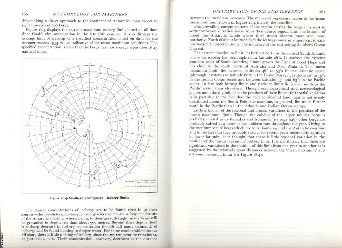
Figurc 18.4 displays the extreme maximum iceberg limit, based on all data sińce Cook’s circumnavigation in the late i8th century. It also displays the averagc limit of iccbergs of a specified concentration based on data for the summer seasons 1954-60, as indicative of the mean maximum conditions. The specified concentration is such that the bergs have an average separation of 45 nautical miles.

Figurę 18.4. Southern hemisphere—Iccberg iimits
The largest concentrations of icebergs are to be found close in to their sourccs—the ice-shclvcs, ice-tongues and glaciers which are a freouent featurc of the Antarctic coastlinc whcrc, owing to their great draught, many bcrgs will be grounded in dcpths less than about 300 metres. Bcyond thcsc dcpths there is a sharp dccrease in iceberg concentration though still many thousands of iccbergs will be found floating in deeper water. For somc considcrable distance off shore there is little mclting of iccbergs sińce the sca temperaturę remains at, or just bclow, o°c. Their concentration, howevcr, dccrcascs as the distance
DISTRIBUTION OF ICE AND ICEBERGS 261
betwccn the meridians increases. The main mclting occurs ncarcr to the ‘mean maximum’ limit shown in Figurę 18.4 than to the coastline.
The prevailing current pattern of the region carrics the bcrgs in a west to west-north-west direction away from their sourcc region until the latitude of about the Antarctic Circle where their tracks bccome morę and morę northerly. North of about latitude 63°s the icebcrgs move in a morę east to east-north-easterly direction under the influence of the east-setting Southern Ocean Current.
The extremc maximum limit lies furthest north in the central South Atlantic where an iceberg has been sighted in latitude 26 S. It encloses the extreme Southern coast of South America, almost grazes the Cape of Good Hope and lies close to the south coasts of Australia and New Zealand. The ‘mean maximum limit’ lies between latitudcs 46° to 53cs in the Atlantic sector (although it extends to latitude 6o°s in the Drakę Passage), latitude 46° to 59°s in the Indian Ocean sector and betwccn latitudcs 570 and 63°s in the Pacific sector. In fact both iceberg limits and pack-ice limits lic farther south in the Pacific sector than clscwherc. Though oceanographical and meteorological factors undoubtedly influence the positions of thcsc limits, this spatial variation is in part due to the fact that the cold Continental land mass is not evenly distributed about the South Pole; the coastline, in generał, lies much further south in the Pacific than in the Atlantic and Indian Ocean sectors.
Littlc is known of the seasonal and annual variations in the positions of the ‘mean maximum’ limit. Though the calving of the larger tabular bcrgs is probably related to carthąuakcs and tsunamis, (see page 248) other bcrgs are probably calved at a morę or less uniform ratc throughout the year. Owing to the vast numbers of bcrgs which are to be found around the Antarctic coastline and to the fact that they probably survive for several years before disintegration in lower latitudes, it is thought that there is little seasonal variation in the position of the ‘mean maximum’ iceberg limit. It is morę likely that there are significant variations in the position of this limit from one year to another as is suggested by the relatively great distanccs between the ‘mean maximum’ and extreme maximum limits (see Figurę 18.4).
Wyszukiwarka
Podobne podstrony:
256 257 (10) 256 METEOROLOGY FOR MARINERS Distribution of Sea Ice at the Time of G
266 267 (10) 266 METEOROLOG! FOR MARINERS An cfTcct which is sometimes ovcrlookcd is that of atmosp
Kalman-Bucy Obsener Design for Multivanable Ship Motion Control Mirosłcnv TOMERA Optimum Operation o
crosa-sectional araes by 10 and 50%, and, finally, two struc-tural ełements in the mkłdle of the tel
Volume 59-2021Cali for Papers.. Travel and Tourism Law in the Face of ContemporaryThreats to Tourist
DSC00902 (9) Tests for module 1 CSTboracic vertebrae are distinguished by the presence of: (UMsnCu.l
guideblock dim Guideblock mount Identical for upper and lower guidesBack side below the surface of t
REFERENCES AND BIBILIOGRAPHY FOR FURTHER RESEARCH Adembe, Ray. “A Reevaluation the Fiction of Allen
260 261 Rozdział 10. Konflikty społeczne Korporacyjna procedura rozwiązywania konfliktów nie była do
264 265 (10) METEOROLOG! FOR MARINERS 264 speed at the locality in qucstion but also upon the diffe
f20 10 Multiple Selection for Short description Select Single ualue selections {*date^ n [*] *Date*
11 Plant metaphors for the expression of emotions (10) Her pretty face reveals a m
IMG&0 261 (2) .10* .10* 300 gniot Rys. 11.10. Wykres rekrystalizacji (Czochralskicgo) żelaza
skanowanie0209 Seeman M. 13, 160, 188, 189 202, 211, 219, 225, 259, 260, 261, 301v 401 Sei
Physics.in Canada/10 auchorlzed to perform the duties of the Office for which he is so elected for t
-ig. 3.10. Tubular plant for processing fruit juicc (Courtesy of Paterson Candy International) Fig.
więcej podobnych podstron