
A
MSTERDAM
G
UIDE
A Self-Guided Walking Tour of about 4½ hours
which includes stops and / or museum visits of up to 2½ hours
Created for Visitors from Legend of the Seas - 30 April 2014
developed by Roy Smith ©2013

Contents
WELCOME TO AMSTERDAM
A������� A� T�� C����� T�������................................................................................................................1
The Port’s Place In History......................................................................................................................1
The Golden age.......................................................................................................................................1
The 20th Century....................................................................................................................................1
SOME BASICS
T������ T������ S����..................................................................................................................................2
A CIRCULAR WALK � 4½ HOURS
I�������� ����� / ������ ������� �� �� 2½ �����.....................................................................................5
Passenger Terminal to Damrak...............................................................................................................5
St Nicholas’ Church..................................................................................................................5
Damrak....................................................................................................................................6
Damrak to Dam Square...........................................................................................................................6
Dam Square.............................................................................................................................7
Koninklijk (Royal) Palace..........................................................................................................7
The Amsterdam National Monument.....................................................................................7
The Nieuwe Kerk.....................................................................................................................7
Dam Square to Westermark....................................................................................................................8
Westerkerk (West Church)......................................................................................................9
The Anne Frank House............................................................................................................9
Westermarkt to Munttoren..................................................................................................................10
Museum of the Canals...........................................................................................................10
Houseboat Museum..............................................................................................................10
Munttoren (mint tower)........................................................................................................11
Munttoren to Rembrandt House Museum...........................................................................................11
Rebmrandt House Museum to De Waag..............................................................................................12
De Waag................................................................................................................................12
De Waag to Passenger Terminal...........................................................................................................13
Additional Sightseeing...........................................................................................................................13
Maritime Museum & Nemo..................................................................................................13
Summary of Timings..............................................................................................................................14

1
A�������� S��� G����� T���
C������� W��� F��� C����� T�������
W
ELCOME TO
A
MSTERDAM
Arriving At The Cruise Terminal
P
assenger Terminal Amsterdam (PTA) is the
city’s official port for cruise ships. The
structure is an eye-catching building on the IJ
River (pronounced Eye) and the PTA welcomes about
200,000 passengers annually. Just in front of the PTA
are the berths used by River Cruise Vessels and on
most days a number of these can be seen at the
moorings.
The Port of Amsterdam lies at the head of the
Ijsselmeer, a shallow freshwater lake in the ‘North
Holland’ province of The Netherlands.
While the seat of government for The
Netherlands is at The Hague, the Port of Amsterdam
is the country's official capital. The Port of
Amsterdam is the major centre for culture and
finance in The Netherlands.
In 2012 over 740,000 people lived in the city of
Amsterdam, and over 2.1million called the
metropolitan area home.
The PTA is located a few hundred metres from the
City’s Central Railway Station, which is the hub of
Amsterdam. All public transport, trams, metro, buses
and taxis meet here from where visitors may explore
the city or surrounding area with ease.
T�� P���’� P���� I� H������
As early as in 1275 Count Floris V granted the
people living near the man-made dam on the Amstel
River, freedom to navigate the waters of the Province
of Holland - without paying tolls.
By the 16th century a blooming economy helped
Amsterdam to grow into the biggest city in the
province of Holland, with some 30,000 inhabitants.
The IJ waterway was still an estuary; in it was a port
directly connected to Damrak. Ocean-going vessels
could sail right into the city, up to what is today Dam
Square.
Back then, the Dam was covered in small houses,
with a medieval, gothic city hall (replaced in the 17th
century). At this time the city limits were defined by
the Singel canal to the west, and the
Kloveniersburgwal (wall) to the east.
T�� G����� ���
The 17th century is considered Amsterdam's
‘Golden Age’, during which it became the wealthiest
city in the world. Ships sailed from Amsterdam to the
Baltic Sea, North America, and Africa, as well as
present-day Indonesia, India, Sri Lanka, and Brazil.
Amsterdam’s merchants had the largest share in
both the Dutch East India Company and the Dutch
West India Company. These companies acquired
overseas possessions that later became Dutch
colonies.
During the 19th Century, Amsterdam entered
what some call its second ‘Golden Age’. The Industrial
Revolution arrived, and new civic buildings including
museums and train stations, and supporting services
appeared.
T�� 20�� C������
Before World War I began, the Port was growing
with new suburbs. While the country was neutral
during the war, the Amsterdam had shortages of food
and heating oil, causing riots in which people looted
stores and warehouses.
In 1940, Nazi Germany invaded and took control of
The Netherlands. They seated a civilian Nazi
government over the Port of Amsterdam that
cooperated in persecuting Jews.
Citizens of the Port of Amsterdam risked their own
freedom or lives by sheltering Jews; not all were
saved. Over 100,000 Dutch Jews were sent to
concentration camps; only 5,000 survived WW2.

2
A�������� S��� G����� T���
C������� W��� F��� C����� T�������
S
OME
B
ASICS
Typical Tourist Stuff
T
he first essential thing to say about visiting
Amsterdam is that almost everyone you meet
will speak English, there will be few exceptions
whilst you are in the city itself. However, it may be
prudent to learn a few Dutch words which you may
hear as you travel around - these are mentioned a
little later in this guide.
Local Time
From 28 March to 31 October Amsterdam is in the
Central European Summer Time Zone, or GMT+2.
However, remember that as cruise ship visitors you
should always take the time from what the cruise
ship tells you; only in rare cases will this be different
from the local time.
Money
Since 2002, a large part of the European Union
has adopted the euro as its local currency and the
Netherlands is no exception. One euro contains 100
euro cents. There are coins of 1, 2, 5, 10, 20 and 50
euro cents, and also of 1 and 2 euro. Banknotes are
available with the following values: 5, 10, 20, 50, 100,
200 and 500. However, it is common practice for
local shops NOT to accept €200 and €500 bills.
You can exchange and withdraw money at most
large banks; there are plenty in the centre of
Amsterdam. All Dutch banks accept Visa and
MasterCard at their cash dispensers, but bear in mind
that ATMs are ridiculously scarce in Amsterdam often
leading to huge queues.
At Amsterdam Centraal Station you can find a
GWK Travelex shop open from 8am. Many
restaurants, hotels and shops accept Visa and
MasterCard, but to avoid disappointment, be sure to
carry some money with you as some bars only accept
cash and others require a minimum purchase of €15 -
20 to use a card.
Tipping
Tipping in restaurants,
if deserved, is up to the
diner, however it is
recommended that both
10% or a rounding up of
the bill is acceptable.
Alcohol
Amsterdam is famous for
its cafés and restaurants so
you’re never far from a tasty
brew or a glass of wine.
Heineken, Amstel and Bavaria
are the nation’s biggest
brewers but other large local
brands include Grolsch and
Hertog Jan. A wide variety of
excellent Belgian brews are
also on offer at most bars, but
keep an eye out for cafés selling beer from
Amsterdam’s own micro-breweries.
You must be at least 16 years old to drink beer or
wine and 18 to imbibe spirits. If you look too young
you’ll be carded, so always bring identification. This
holds true for supermarkets and off-licences, too.
Brown cafés
Bruine (Brown) cafes are to Amsterdam what
pubs are to London. That is, they are casual,
neighbourhood gathering spots located all around
the city, featuring dark wood and people looking for a
drink, a snack and friendly conversation. The term
‘brown’ comes from the dark wood and stained walls
that supposedly owe their hue to years of smoking
patrons.
Amsterdam's brown cafés are as much a part of
the city's charm as its canals and architecture. Most
of them epitomize the Dutch term gezelligheid
(pronounced "khuh ZEL ikh hide"), a word quite
difficult to translate into English; coziness or a feeling
of friendly welcome best describes it.
These should not, however, be confused with
Coffeshops, although many fist time visitors do.
Coffeeshops & Drugs
It comes as no surprise that in many places in the
Netherlands coffeeshops sell marijuana and other so-
called soft drugs to Dutch residents. And you may
have also heard that dealing or possessing hard drugs
is forbidden. You can be arrested for it and
punishments are no laughing matter.
Unfortunately, recent legislation on a national level
has made the legality issue a little hazy.

3
A�������� S��� G����� T���
C������� W��� F��� C����� T�������
Although it is technically forbidden to serve non-
residents, most coffeeshops in Amsterdam still sell
their wares to tourists.
Coffeeshops are alcohol-free establishments
where soft drugs
are sold and
consumed. A
driving principle
of coffeeshop
policy is that the
sale of alcohol
and the sale of
soft drugs is
separated.
Prostitution
It may surprise you to know that the profession
that has helped to make Amsterdam a household
word across the globe, only became legal in 2000.
For years, the Dutch did what they always do
when confronted with a sticky social problem. The
police simply turned a blind eye to the practice and
tolerated it. The cops in the Red Light district only
rousted sex workers if they became too aggressive
with passers-by showing off body parts or tapping on
the glass.
Today, window shopping on the Oudezijds
Achterburgwal is a popular tourist attraction, but
please bear in mind that these ladies are there to
make a living and are not part of some open-air zoo.
Be respectful and, whatever you do, don't take any
photographs up close. Use a zoom lens from a
distance if you want some photographic evidence of
your visit.
Cycling
It is estimated there are over 880,000 bicycles in a
city of 780,000 residents. There are cycle paths
everywhere in Amsterdam and .
Cyclists in Amsterdam have a reputation of being
somewhat anarchistic and are perhaps even proud of
this reputation. The fact that they often ignore the
rules of the road can cause problems.
Cyclists are not permitted to cycle through red
lights, although they often do.
Trams
Amsterdammers love their trams and you should,
too! They provide the best way of getting around the
city and run from 06:00 - 00:30.
You shouldn't have to wait longer than 10 minutes
at any tram stop. One-hour tickets for journeys across
the city can be bought from newsagents or tram
drivers. They cost €2.80 (2013), but if you plan on
travelling a lot you’re better off purchasing a 24-hour
ticket for €7.50. You have to touch the scanner near
the doors of the tram when entering and exiting.
Pickpockets
Sadly, as with many other major cities pickpockets
are typically active in crowded places, during the
summer season. This can occur in a tram or while
watching a street artist. Mind your belongings
carefully, and leave your valuables onboard the ship.
Police
If you are a victim of crime go to one of the police
stations. They will take a statement, cancel your
credit cards in case of theft and provide you with
useful telephone numbers and addresses (like
consulates, etc). Please try to avoid problems by not
carrying valuable items with you on the streets.
Some Useful Words?
Hello
Hallo
Good morning
Goedemorgen
Good afternoon
Goedemiddag
Goodbye
Dag
Excuse me
Pardon
Thank you
Dank u
Thank you very much
Dank u wel
pronounced (dank u vel)
Please
Alstublieft
pronounced (alst-u-bleeft)
Yes
Ja (Yar)
No
Nee (Nay)
Sorry
Sorry

4
A�������� S��� G����� T���
C������� W��� F��� C����� T�������

5
A�������� S��� G����� T���
C������� W��� F��� C����� T�������
A C
IRCULAR
W
ALK
- 4½
HOURS
Including stops / breaks lasting up to 2½ hours
T
his walk begins and ends at the passenger
terminal where the cruise ship will dock. The
route takes in you to a number of Amsterdam’s
main city centre sights and includes time for a one
hour visit to The Anne Frank House; you will need to
buy your tickets online in advance.
P�������� T������� �� D�����
As you leave the passenger terminal you are
faced with a major road, across the other side
of which are the tram tracks. For the purposes
of this tour simply stay on the footpath
alongside the road (Piet Hienkade), passing the river
cruise berths on your right, until you reach a
pedestrian crossing; Central Station is ahead and to
your left.
Cross over the road to your left and walk under
the railway bridge along Oosterdokskade and keep
going until you pass from under the rail bridge, you
are now on Stationsplein. There are always building
works due to the ongoing extension of the
Amsterdam Metro so make your own judgement
about where to cross the roads and head towards the
far side of the main road - Prins Hendrikkade.
Your target is to get to the top of Damrak near the
Park Plaza Victoria Hotel, passing the Church of Saint
Nicholas on your left. As you reach the main
construction works make your way safely around
them and you will find yourself on Damrak, the main
thoroughfare which leads past canal cruise docks
towards Dam Square and the Royal Palace.
Distance: 1.7km / 26mins
St Nicholas’ Church
S
T
N
ICHOLAS
’ C
HURCH
The Basilica of St. Nicholas is located in the
Old Centre district of Amsterdam. It is the city's
major Catholic church. Officially the church was
called St. Nicholas inside the Walls, i.e. the oldest
part of the Amsterdam defence works. Built
between 1884 and 1887. The architect was
Adrianus Bleijs (1842-1912).
At 58 meters tall, the Baroque dome toward
the rear is one of the most noticeable features of
the church, a seamless mix of neo-Baroque and
neo-Renaissance elements; two shorter towers rise
from either side of the church's entrance.
Victoria Hotel

6
A�������� S��� G����� T���
C������� W��� F��� C����� T�������
D
AMRAK
This part of your walk takes you along Damrak
which is actually a partially filled in canal. Running
north-south it is the first sight that many visitors
get as they arrive at The Central Station.
Damrak is also one of the two tram routes that
run from the station into the city. The metro
extension is presently being built underneath
Damrak; the cause of many years disruption and
expense; over €3bn. The street was originally
located on a ‘rak’ (reach), a straight part of the
Amstel river near a dam; hence the name.
Because of the former stock exchange building,
the monumental Beurs van Berlage, and several
other buildings related to financial activities
erected there in the early 20th century, the term
‘Damrak’ has come to be a synonym for the
Amsterdam Stock Exchange in the same way ‘Wall
Street’ is synonymous with the New York Stock
Exchange.
D����� �� D�� S�����
You are now standing at the northern end of
Damrak with shops, hotels and restaurants on
the right hand side of the road. To your left,
you will see building works and then an open
area of canal basin with the moorings for canal
cruises.
Walking south you will shortly reach a red-brick
built structure, the ‘Beurs van Berlage’ the old Stock
Exchange. The road to the left ust before you reach
this building, running alongside the canal, is called
Oudebrugsteeg and leads directly into the Red Light
District. The building you can see on your left the ‘The
Grasshopper Bar’ is one of Amsterdam’s most
favourite nightspots.
As you continue to walk you will see on you right,
a number of small passages between shops, these
lead directly into the main shopping street of the city;
Nieuwendijk. This street runs parallel to Damrak, so if
you feel confident why not head over there and take
a look around. If you walk south on Nieuwendijk you
will reach Dam Square again.
A little further along Damak, you reach the
Beursplein (Stock Exchange Square). The next building
is the upmarket department store ‘de Bijenhorf’
whose history dates back to 1870, when Philip
Goudsmit opened its first shop selling buttons and
sewing supplies.
Just before you enter Dam Square, which you will
now see in all of its glory, take note of the ABN AMRO
bank on the right-hand side of Damrak - this is one of
the few banks that has an ATM machine in this part of
the city.
Distance: 600m / 9mins
Buers van Berlage (old stock exchange)
de Walletjes
Red Light District
ABN AMRO - ATM
7
A�������� S��� G����� T���
C������� W��� F��� C����� T�������
D
AM
S
QUARE
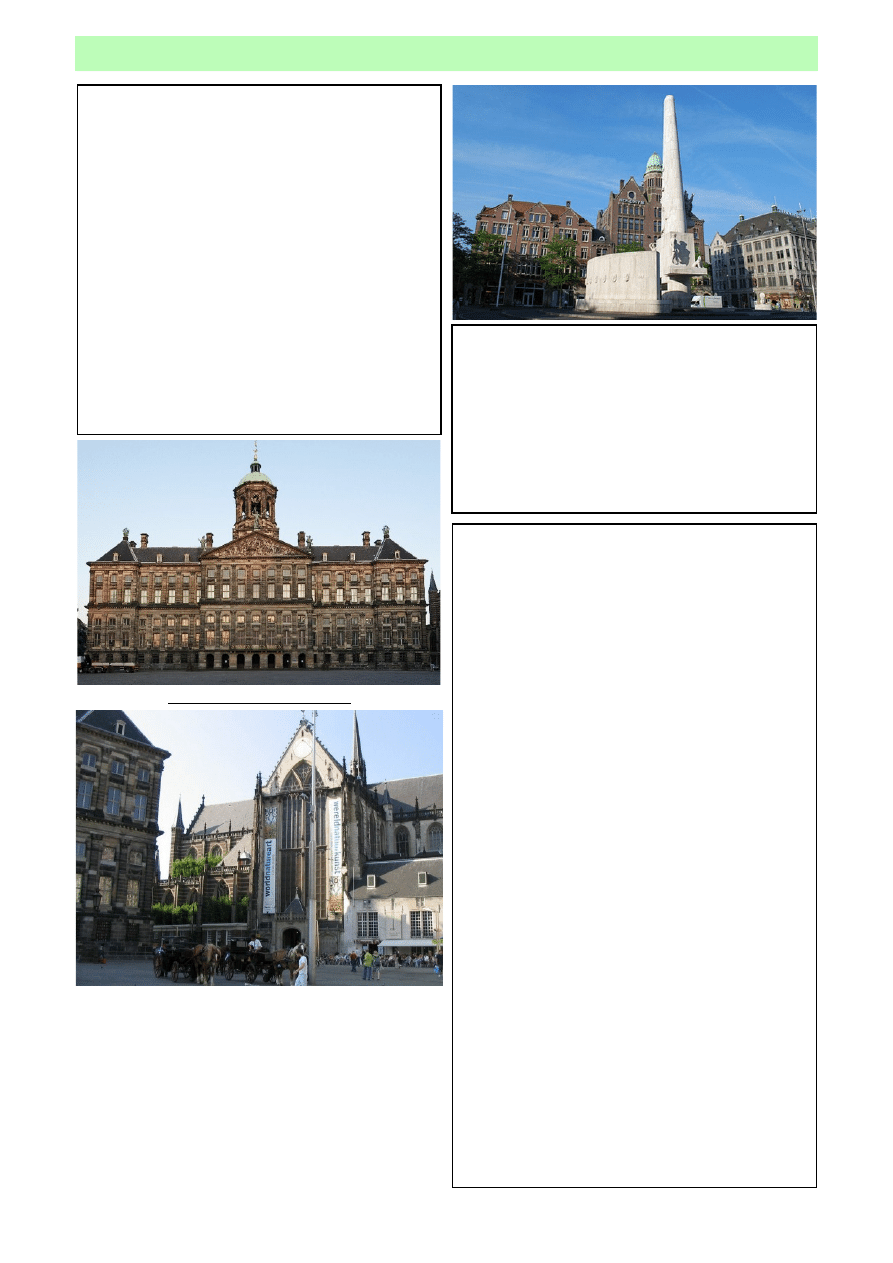
As you arrive in Dam Square you will be
greeted by three of the most famous historic sights
in the city; The Royal Palace, The National
Monument and the Nieuwe Kerk (New Church).
Dam Square itself was created in the 13th
century when a dam was built around the river
Amstel to prevent the Zuiderzee Sea from
flooding the city, causing damage and endangering
the citizens of Amsterdam.
Through the centuries, a number of buildings
sprung up around the Square, special events were
(and still are) held here, and street entertainers are
a common site. In addition to several restaurants,
cafés, and shops, there are many excellent
attractions to visit in Dam Square.
K
ONINKLIJK
(R
OYAL
) P
ALACE
Built as a city hall for the magistrates of
Amsterdam, it was the largest secular building in
Europe in the 17th century. The building has
served a number of different purposes since its
construction by Dutch architect Jacob van Campen.
Though it’s difficult to tell now, the entire building
was made of gleaming white stone. Originally built
to be the City Hall for the magistrates of
Amsterdam, its first section opened in 1655.
Through the centuries, the building has been
known not only for its size and beautiful exterior
but also for what’s inside the Royal Palace. After it
was built, famous sculptors and painters were
brought to Amsterdam to create masterpieces to
be exhibited there including Rembrandt.
The City Hall became the Royal Palace when
Louis Napoleon, brother of the famous emperor,
was appointed to rule over Holland as king in the
early 1800s. He decided to take over the building
and, in turn, converted it to a palace. He decorated
in Empire style and many of his furnishings can
still be viewed by tourists today.
When Napoleon Bonaparte’s empire fell the
structure was returned to the city, but not for long.
King Willem I (of Orange) liked it decided he’d
reside there. Royalty continued to use the palace
until 1936, when it again became a public building.
The building remains at the King’s disposal for
state functions and is used often for such
ceremonies.
The Koninklijk (Royal) Palace
T
HE
A
MSTERDAM
N
ATIONAL
M
ONUMENT
Erected in 1956 it honours the victims of
World War II. It was designed by Dutch architect
J.J.P. Oud, and the monument’s sculptures are by
John Rädecker and his sons Han and Jan Willem
Rädecker. The central element of the monument is
a concrete conical pillar 22 metres in height,
covered entirely by white travertine stone
T
HE
N
IEUWE
K
ERK
Adjacent to the palace stand the Nieuwe Kerk
(above). It was originally built about 1400 and
restored to its original grandeur in the mid-1600s
after a major fire. It was built in early Renaissance
style. Both inaugurations and royal weddings have
been held in this magnificent church. Guests enjoy
viewing the famous stained glass windows and
listening to concerts performed on the pipe organ.
8
A�������� S��� G����� T���
C������� W��� F��� C����� T�������
D�� S����� �� W���������
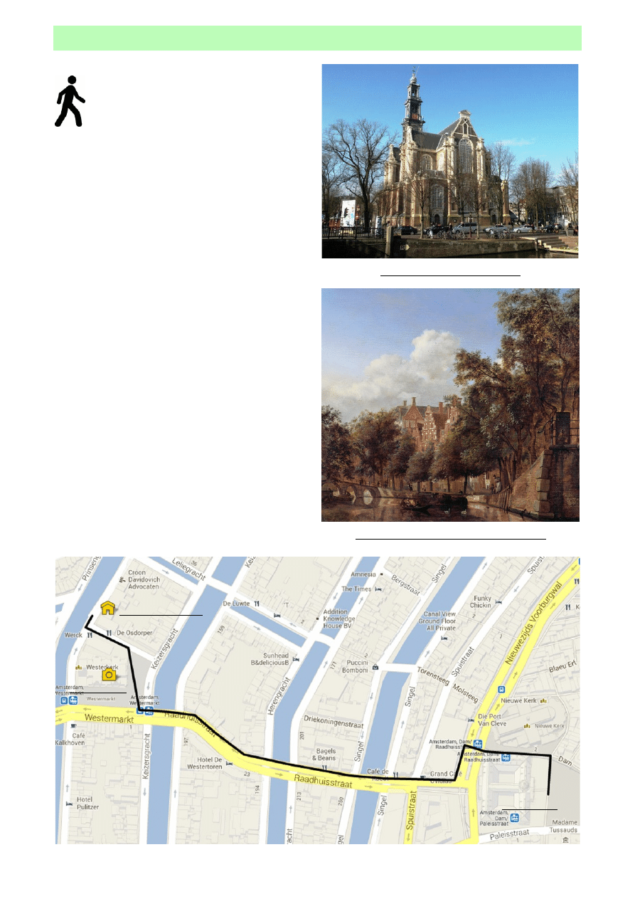
The next leg of your walk takes you out of
Dam Square to the right-hand side of the
Royal Palace keeping the Nieuwe Kerk on your
right. As you leave Dam Square take care of
the trams that run through the gap between the two
historic buildings, the road is narrow.
There is a pedestrian crossing in front of you
leading over Nieuwezijds Voorburgwal towards the
doors of Magna Plaza, which is another high class
shopping centre - and worth a stop if you have time.
Once in front of Magna Plaza walk to the left (as
you face it) and turn right down Radhiusstraat. Keep
walking until you cross over the first canal. This is
called the Singel and forms the first ring of major
canals in the city.
The next canal you cross is the Herengracht or
Gentleman’s canal and enter a small shopping area;
here you will get four first sight of the Westerkerk in
the distance. The Westerkerk sits between the other
two mjaor canals, the Keizersgracht or Emperors
canal and the Prinsengracht or Princes canal.
These last three canals were constructed in 1613
during the city’s first major expansion. These were
constructed around the old medieval city in
semicircles. This band of canals was added to the
UNESCO world heritage list in 2010.
Alongside the Westerkerk you will find The Anne
Frank House Museum and also the Homomonument.
Distance: 850m / 13mins
Allow at least 1 hour to visit the Anne Frank House.
Dam Square
Westermark
Herengracht, by Jan van der Heyden 1670
The Westerkerk (West Church)
Anne Frank House
9
A�������� S��� G����� T���
C������� W��� F��� C����� T�������
W
ESTERKERK
(W
EST
C
HURCH
)
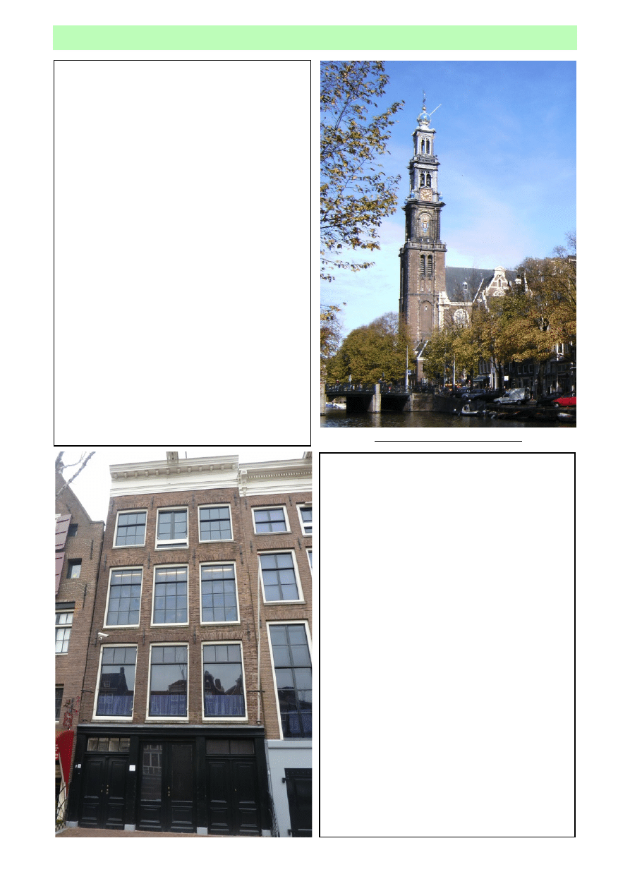
The Westerkerk is a protestant church that has
been in use since 1631. It features a memorial
plaque to Rembrandt, and its impressive tower
contains a carillon with 48 bells, many of which
were crafted by the renowned Hemony brothers.
The architect was Hendrick de Keyser who built
the church in the Dutch Renaissance style, which
is characterized by a combination of brick and
stone.
The tower bears the symbol of the imperial
crown of Maximilian the First of Austria, which he
presented to the city in gratitude for its loyalty to
the Austro-Burgundian princes.
In 1669 Rembrandt van Rijn was buried here,
just as was his son Titus was a year earlier.
The Westertoren (West Tower) has inspired
many Dutch songs and poems and remains a well-
known symbol of Amsterdam. It is 85 meters high
and is the tallest tower in the city, Amsterdammers
call the tower soothingly the D'Oude Wester.
The tower owner is not the church community,
but the municipal government as were all 17th
century towers; they served particularly as
observation posts for the fire brigade.
The Westertoren - 85 metres tall
T
HE
A
NNE
F
RANK
H
OUSE
The Anne Frank House (left) is a museum
where visitors are given the opportunity to
personally envision what happened on this very
spot. The secret annex, where Anne and her
family hid from the Nazis is preserved for
posterity.
The front part of the house, the place where
the helpers worked and Otto Frank’s former
office, has been returned to the style and
atmosphere of the hiding period; visitors are
provided with the opportunity to feel personally
involved in what occurred at this location.
The old canal-side house at 265 Prinsengracht,
next to Otto Frank’s former office, has been
renovated. Here, information is given about the
diary and its significance. Anne Frank’s original
diaries and other writings are on display.
The story is told using quotes from Anne’s
diary as a reference. Original objects, documents,
and photographs that are on display in the
exhibition serve in strengthening the personal
account of the hiding period and of the
deportation to the camps. Three short films place
the personal story in a historical context.
10
A�������� S��� G����� T���
C������� W��� F��� C����� T�������
W���������� �� M��������
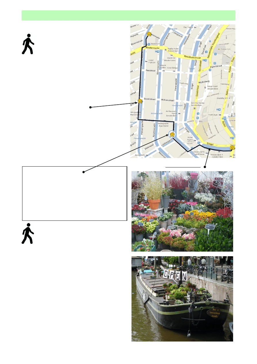
The next leg of the walk takes you along the
banks of the Prinsengracht, the outer
boundary of canal ring towards the Houseboat
Muesum, onto Herengracht and the Museum
of the Canals before visiting the floating flower
market and ending at the Munt Tower.
Leaving Westermarkt head across the bridge over
Prinsengracht canal and turn left following the canal
south. As you approach Berenstraat, the second
bridge on your left you will see the signs for the
Houseboat Museum. It is just opposite a small square
called Johnny Jordaanplein.
A visit to the Houseboat Museum is interesting
and shows how many people in Amsterdam used to
live but also many live now.
Keep walking south and cross over the next bridge
walking east along Runstaad. Cross over Keizergracht
and arrive at Herengracht. Turn right, keeping the
canal on your left and shortly arrive at the Museum
of the Canals (Het Grachtenhuis) at number 386
Herengracht.
M
USEUM OF THE
C
ANALS
Museum Het Grachtenhuis is the gateway to
the canals of Amsterdam.
One of the world’s greatest urban projects - the
17th century Amsterdam canal district - is
presented in six rooms. Visit the multimedia,
interactive exhibition and travel through 400 years
of history in 40 minutes.
As you continue along Herengracht the canal
begins a to curve to the east and you cross a
point where the Leidsegracht canal joins the
main canal. At the next bridge you have
arrived at Leidsestraat on your right (one of the main
shopping streets in this part of the city - noticeable by
the double tram tracks) and Koningsplein on your left;
over the bridge.
Turn left and walk a short distance eastwards,
along Koningsplein, until you arrive at the Singel
canal. Your next direction will become clear as you
see and maybe smell the wonderful selection of
flowers and plants to your right at the Bloemenmarkt;
the floating flower market. Passing through the flower
market you reach Muntplein and to your left, the end
of this leg of your trip, the Munttoren (Mint Tower).
Distance: 1.5km / 23mins without stops.
Allow - 30mins at for a visit to the houseboat museum
and 40mins at the museum of the canals.
The Bloemenmarkt
H
OUSEBOAT
M
USEUM
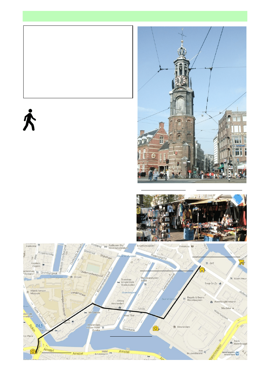
11
A�������� S��� G����� T���
C������� W��� F��� C����� T�������
M
UNTTOREN
(
MINT TOWER
)
The Munttoren was once part of the
Regulierspoort which consisted of a gate with a
tower on each side. It was built between 1480 and
1487 as part of the medieval city wall. In the 17th
century, the tower was used to mint coins. After a
fire in 1618, only the guard house and part of the
western tower remained. It was rebuilt around
1620, with a spire designed by Hendrick de
Keyser. The carillon consists of 38 bells that
chime every 15 minutes.
Above: The Munttoren
Below: The Flea Market
M�������� �� R�������� H���� M�����
Keeping the Munttoren on your left you will
see a two-lane road this is called Rokin. A
pedestrian crossing leads to the ‘Hotel De
l’Europe’ with a narrow to its left called
Nieuwe Doelenstraat - head that way.
Follow this road until you reach a bridge on your
right, cross this bridge And you are onto Staalstraat.
This bridge is typical of the many lifting bridges that
are scattered throughout the city.
Continue directly ahead crossing two more
bridges, the second of which takes you over the
Amstel River and onto Waterlooplein. It is here that
you will find the local flea market and Jewish War
Memorial; both are in front of the Netherlands Opera
House. Walk north along the Amstel River and this
part of your walk ends as you reach Jodenbreestraat.
The Rembrandt House Museum is a short distance to
your right and the Gassan Diamond Factory is also
close by.
Distance: 700m / 11mins
The Munttoren
Jewish War Memorial
Rembrandt House Museum
Gassan Diamond Factory
12
A�������� S��� G����� T���
C������� W��� F��� C����� T�������
R�������� H���� M����� �� D� W���
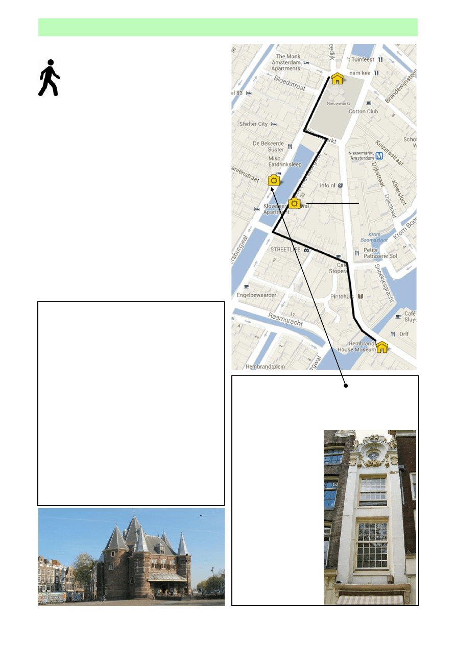
On this stage of the walk you head across the
Amstel River and head into the heart of the old
town. Proceed along Sint Antoniesbreestraat
until you reach a small ‘cycles only’ street on
your left called Nieuwe Hoogstraat. Follow this street
until you reach Kloveniersburgwal canal and turn
right here.
As you reach number 29 Kloveniersburgwal you have
found the widest building in Amsterdam and if you
look across the canal at number 26 the narrowest
house in the city is facing you. Continue along the
canal side until you reach the large open square
directly ahead, this is the Nieuwmarkt or New Market.
walk around the square on the left-hand side and you
will see bars and cafés serving a variety of
refreshments.
In the northern end of Nieuwmarkt sits ‘de Waag’ -
the ‘old weigh house’, a restaurant and café serving
traditional Dutch food. This is the end of this part of
your walk.
Distance: 500m / 8mins
T
HE
K
LEINE
T
RIPPENHUIS
At Kloveniersburgwal 26 (stands a house with a
beautiful cornice gable, 2.44 meters (about 8 ft.)
wide. This is known as the ‘Kleine Trippenhuis’ or
‘the House of the Mr.
Trip’s Coachman’.
This house is driectly
across the street from
the ‘Trippenhuis’ at
number 29, a building
that, with its width of
22 meters (72 ft. 2 in.),
is the widest house in
Amsterdam.
Both buildings date
from 1660 at which
time they were built by
the very wealthy
brothers Lodewijk and
Hendrick Trip.
The Trippenhuis
D
E
W
AAG
Constructed in the 15th century, de Waag (or
the Weigh House) has served a number of
different purposes. Built in 1488, the building was
intended to be one of Amsterdam’s three city
gates. This particular one was known as St.
Anthony’s Poort. The gate served this purpose
until about a century later - in 1601 - when the city
tore down its walls to make room for expansion.
Amsterdam found a new purpose for this
beautifully ornate gate as a weigh house. Goods
were - obviously - weighed here and it was also in
this building that taxes were levied.
The dark period for St. Anthony’s Poort came
during the early 19th century, when Napoleon
ordered public executions be performed here.
In 1996, the Restaurant-Café ‘In de Waag’
(below) opened inside the old gate.
13
A�������� S��� G����� T���
C������� W��� F��� C����� T�������
D� W��� �� P�������� T�������
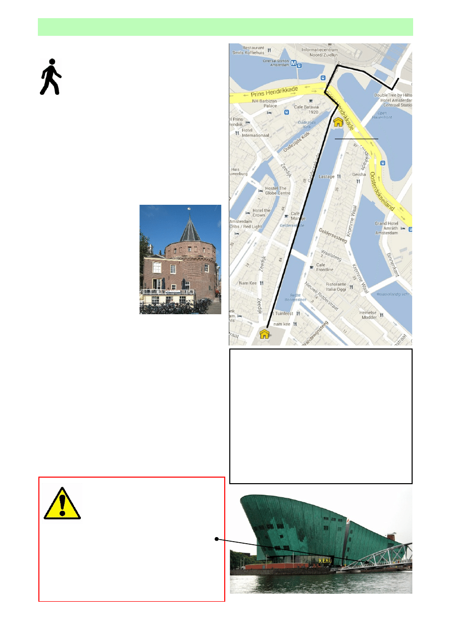
The last leg of your walk takes you from
Nieuwmarkt directly back to the Amsterdam
Passenger Terminal and your cruise ship.
You are waking through some of the oldest
parts of the city, along the bank of the Geldersekade
canal. This was dug in the late 15th century and
together with the Kloveniersburgwal canal and the
Singel canal, formed the ‘urban moat’ around the
city.
The Geldersekade ran from St. Anthony’s Gate
(now de Waag) to the north and culminated in the
Schreierstoren in the IJ (Eye River). On the city side of
the canal (the west bank) stood the city wall.
As you reach the and of
Geldersekade you will see,
on your right the
Schreierstoren (right), an
ancient defence tower. Built
around 1487 on the corner
of the IJ and the east side of
the city, the tower is the
only preserved defence
tower of Amsterdam.
From here you turn left
and head or the pedestrian crossing which you used
at the start of the route to make your way back to
Stationsplein. You return to the passenger terminal
by re-tracing your the route at the start of this guide.
Distance: to Schreierstoren 500m/ 8mins
Distance: from Schreierstoren to passenger
terminal 1km / 15mins.
Schrierstoren
A��������� S����������
Once you reach Schreierstoren and you if have the
time you will see the open harbour area called the
Ooseterdock or (East Dock). As well as being a
pleasant area itself there are two places of interest;
The Maritime Museum and Nemo.
M
ARITIME
M
USEUM
& N
EMO
The Scheepvaart (Maritime) museum, housed
in a 350-year-old warehouse, formerly an arsenal
for the Admiralty of Amsterdam, is truly one of
the best maritime museums in the world, offering
the most comprehensive look at the Netherlands’
centuries-long tie to the sea.
Dominating the skyline close by you will see
NEMO (below), the Netherlands’ largest science
centre. and is described as the “place to discover
science and technology in a fun and educational
way”.
Caution is required if you decide to add
a walk around the Oosterdock to your
itinerary at the end of the day. Whilst
there is a route back to the passenger
terminal, from a point close to Nemo via
the bridge you can see in the photograph opposite,
there are two swing bridges and an area often
undergoing construction work which could delay
your return to the ship significantly.
Should you choose to visit this area, you do so
entirely at your own time risk .

14
A�������� S��� G����� T���
C������� W��� F��� C����� T�������
S������ �� T������
Passenger Terminal to Damrak
1.7 Km ,
26 mins
Damrak to Dam Square
0.6 Km ,
9 mins
Dam Square to Westerkerk
0.9 Km ,
14 mins
Westermarkt to Munttoren
1.5 Km,
23 mins
Munttoren to Rembrandt House
0.7 Km,
11 mins
Rembrandt House to de Waag
0.5 Km,
8 mins
de Waag to Schreierstoren
0.5 Km,
8 mins
Schreierstoren to Passenger Terminal
1.0 Km,
15 mins
Estimated overall walking distance and time
7.3 Km,
1 hr 54 mins
4.5 miles
Approximate time to add on if making stops at:
Anne Frank House Museum (pre-booked)
60 mins
Houseboat Museum
20 mins
Museum of the canals
40 mins
Rembrandt House Museum
30 mins
Gassan Diamond Factory (pre-booked private tour)
60 mins
Details of Trams to / from:
Passenger Terminal to/from Central Station
#26 to ‘Centraal Station’
Central Station to Westermarkt
# 13 to ‘Guezenfeld’ or # 17 to ‘Osdorp’
Westermark to Munttoren
# 14 to ‘Flevopark’
To return to Centraal Station use any tram with the sign on the front: ‘Centraal Station’
Disclaimer: The contents of this guide are believed correct at the time of publication. Nevertheless the author cannot accept
responsibility for errors or omissions, or for changes in details given in this guide, or for the consequences of any reliance
on the information provided by the same. Assessments of distances, timings, restaurants, cafe’s, museums and other attractions
are based on the authors own experience, and therefore descriptions given in this guide necessarily contain an element of
subjective opinion which may not reflect that of the users.
Distances are assessed using Internet based mapping services. Timings are based on what a reasonable person, in reasonable
health may be able to achieve; an average of 4km (2.5miles) per hour is used to assess timing.
Wyszukiwarka
Podobne podstrony:
Niepelnosprawny turysta
Alpejski region turystyczny 2
Produkt turystyczny 2
Rynek turystyczny Antarktydy i Grenlandii
Historia turystyki na Swiecie i w Polsce cz 4
Miłosz Gromada Zakopane i powiat zakopiański Centrum polskiej turystyki
Turystyka, wykład VIII, Agroturystyka
RYNEK TURYSTYKI BIZNESOWEJ W POLSCE
Strategia w branży turystycznej
Regiony turystyczne Europy 2008
Cechy podaży turystycznej1
Międzynarodowe projekty inwestycyjne w turystyce
Monitoring zrwnowaonej turystyki
więcej podobnych podstron