Canyon Origins
Although the origin of Grand Canyon is complex
and not totally deciphered, the forces that shaped
it are well understood. Grand Canyon is the result
of erosion, specifically incision by a river into a
high, arid plateau. The Colorado River carved the
depth of the canyon as it cut its way through the
Kaibab Plateau which is more than 7,000 feet
(2,100 meters) above sea level. Side canyons,
scoured by summer thunderstorms and winter
snow melt, produce much of Grand Canyon’s 10 –
16-mile (16 – 22 km) width.
Compared to the rocks exposed in its walls,
Grand Canyon is geologically young. Excavation
of the canyon occurred within the last six million
years or so. The question of how the Colorado
River evolved its present course is still unresolved,
even though geologists have hypothesized for
years about how the river first established its path
across the plateau and carved this immense
chasm. Much of the uncertainty regarding the
exact age and history of the canyon centers on the
reality that we have only scattered bits of evidence
to reconstruct its history and to precisely date its
origin. The history of the Colorado River is obvi-
ously complex and will be the subject of geologic
research for years to come.
The Landscape
The grandeur of Grand Canyon lies not only in its
size, but also in the beauty of its landscape. In this
respect, Grand Canyon shares many characteris-
tics with its neighbors — Zion, Bryce,
Canyonlands, Arches, and Capitol Reef National
Parks. Like Grand Canyon, these neighboring
parks lie within the geologic province known as
the Colorado Plateau, a region characterized by
mostly flat-lying sedimentary rocks that have been
raised thousands of feet above sea level, then
carved by erosion.
Landforms here are beautifully sculpted and well
exposed due, in part, to climate. The semi-arid
climate that predominates in the Southwest means
that instead of tree-covered slopes and thick soils,
bedrock is at the surface. Therefore, rain does not
soak into the ground; instead it runs off in huge
floods carrying away grains of rock. Cycles of
freezing and thawing in the winter widen cracks
in the rocks, eventually producing rockfalls. Soft
layers erode more rapidly undermining the hard
layers above. Bit by bit, flashflood by flashflood,
and rock fall by rock fall, the canyon continues
to grow.
Each of the rock units within the canyon erodes
in its own manner, yielding the characteristic
stepped-pyramid look of the canyon. Shales erode
to slopes, while harder sandstones and limestones
tend to form cliffs. The extremely hard metamor-
phic rocks at the bottom of the canyon produce
the steep-walled and narrow Inner Gorge, as these
rocks are more resistant to erosion than the softer
sedimentary rocks above.
Color is also an important feature of this land-
scape. Many of these colors are due to the pres-
ence of small amounts of iron oxides and other
minerals that are either in the rock itself or stain
the surface and mask the true color of the rock.
The River Below
The Colorado River flows 277 river miles (446
km) from Lees Ferry to the Grand Wash Cliffs,
the accepted beginning and end of Grand Canyon.
Hidden in the narrow Inner Gorge, the river is
visible from only a few spots along the trail. From
the rim, the river looks puny, yet it averages 300
feet (90 m) wide and features a series of fierce
rapids. From its origins high in the Colorado
Rockies, the river drops more than 12,000 feet
(3,700 m) and passes through a series of canyons,
including the Grand Canyon, on its 1,450-mile
(2,300 km) journey to the Gulf of California.
The name
Colorado is derived from Spanish for
reddish, reflecting the heavy sediment loads the
river once transported. Dams now bracket Grand
Canyon — Glen Canyon Dam (Lake Powell)
upstream and Hoover Dam (Lake Mead) down-
stream. As a result of these dams, the dynamics of
the Colorado River through Grand Canyon
changed dramatically. Gone are the large annual
floods that carried hundreds of thousands of tons
of sediment through the canyon each day.
Today, the Colorado is seldom its natural muddy
red-brown color. Only when tributaries down-
stream from Glen Canyon Dam, such as the Paria
and Little Colorado Rivers, contribute significant
amounts of sediment during flash floods or spring
snowmelt, does the river change from clear blue-
green to its natural reddish-brown.
The North Rim
On the far side of the canyon lies the North Rim,
ten miles away as the raven flies. Although it is
not apparent, the north wall of the canyon rises a
thousand feet higher than the South Rim, giving
the North Rim nearly twice the annual precipita-
tion received here. This considerable difference in
elevation results from the fact that the apparently
flat-lying rocks of the Kaibab Plateau are dipping
gently to the south.
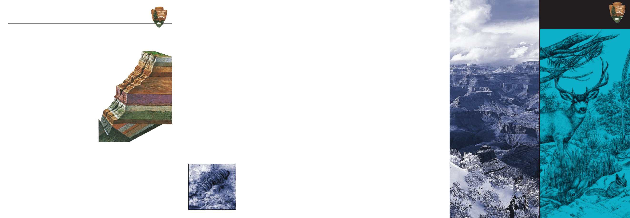
Grand Canyon Geology
The Geologic Record as Told by the Rocks
Fossils of
crinoids, marine
animals that look
like sea lilies,
can be found in
the 260 million
year old Kaibab
Formation.
Nowhere on this planet are the scope of geologic
time and the power of geologic processes as
superbly and beautifully exposed as in these canyon
walls. Rocks equivalent to many of these strata may
be found scattered throughout the United States,
and flowing water has sculpted other landscapes.
Yet, at Grand Canyon, a remarkable geologic
assemblage is exposed in sequence and intact in an
amazing erosional landscape.
The canyon walls reach about 5,000 feet (1,500
meters) below the rim to the river. The thickness of
all Grand Canyon rocks, if present in one spot,
would total more than 15,000 feet (4,600 m). Some
rock units, however, appear only in some parts of
the canyon. The strata of Grand Canyon do not
present a continuous record of Earth’s history. Some
rock layers eroded away before newer layers were
deposited on top producing unconformities,
millions of years of missing time and unknown
geologic stories.
Each rock layer represents a period when a
particular environment of deposition prevailed. For
example, the Kaibab Formation, the rock that makes
the canyon rims, is the youngest of Grand Canyon’s
layers. The Kaibab limestone formed in shallow,
warm seas about 260 million years ago, a bit before
dinosaurs roamed the Earth. Below the Kaibab
limestone caprock, the strata become progressively
older.
The oldest rocks lie more than 3,000 feet (900 m)
beneath the rim in the walls of the Inner Gorge. The
Vishnu basement rocks consist of ancient igneous
and metamorphic rocks that formed deep within the
Earth when island arcs collided with the continental
mass. These crystalline rocks—schist, gneiss, and
granite—are very different in origin and structure
than the sedimentary rocks above them. The Vishnu
basement rocks, including Vishnu Schist, are
between 1,840 and 1,680
million (1.84 – 1.68 billion)
years old. Grand Canyon’s
oldest rock, the Elves
Chasm Gneiss, is not
visible in this part
of the canyon.
National Park Service
U.S. Department of the Interior
Grand Canyon National Park
Arizona
Life Along
the Rim
Geologic Cross Section of Grand Canyon
1. Kaibab Formation . . . . . . . . . . . . . . . .270 my
2. Toroweap Formation . . . . . . . . . . . . . .273 my
3. Coconino Sandstone . . . . . . . . . . . . . .275 my
4. Hermit Formation . . . . . . . . . . . . . . . .280 my
5. Supai Group . . . . . . . . . . . . . . . . .315–285 my
6. Redwall Limestone . . . . . . . . . . . . . . .340 my
7. Temple Butte Formation . . . . . . . . . . .385 my
8. Muav Limestone . . . . . . . . . . . . . . . . .505 my
9. Bright Angel Shale . . . . . . . . . . . . . . . .515 my
10. Tapeats Sandstone . . . . . . . . . . . . . . . .525 my
11. Grand Canyon Supergroup . . .1,250–740 my
12. Vishnu basement rocks . . . .1,840–1,680 my
1.
2.
3.
4.
5.
6.
7.
8.
9.
10.
1.
2.
3.
4.
5.
6.
7.
8.
9.
10.
11.
11.
12.
12.
The South Rim of Grand Canyon marks the northern edge
of a high plateau whose gray-green forests stand out in vivid
contrast to the arid lands below the rim. From here the cliffs
of Grand Canyon drop 5,000 feet/1,500 meters to the Colo-
rado River, crossing several biotic zones. This is a landscape
characterized by abundant sunshine, extremes of tempera-
ture, and long periods of drought, punctuated by downpours
in summer and snow in winter. Precipitation on the South
Rim averages fifteen inches/38 centimeters per year, twice that
received at the river but half that received on the North Rim,
just ten miles across the canyon. Even here at 7,000
feet/2,100 meters above sea level the climate is semi-arid.
It is not what most plants and animals would call a paradise.
The soil is thin; bedrock lies just a few inches below the
surface. The competition for moisture in this arid land is
keen. All the plants and animals that live here must adapt to
the lack of moisture and extremes of temperature that char-
acterize the region.
Rugged as it looks, it is a fragile land whose scars persist
for many years. Walk softly. Be alert to the sights, sounds,
and smells that surround you, for there is much to experi-
ence here.
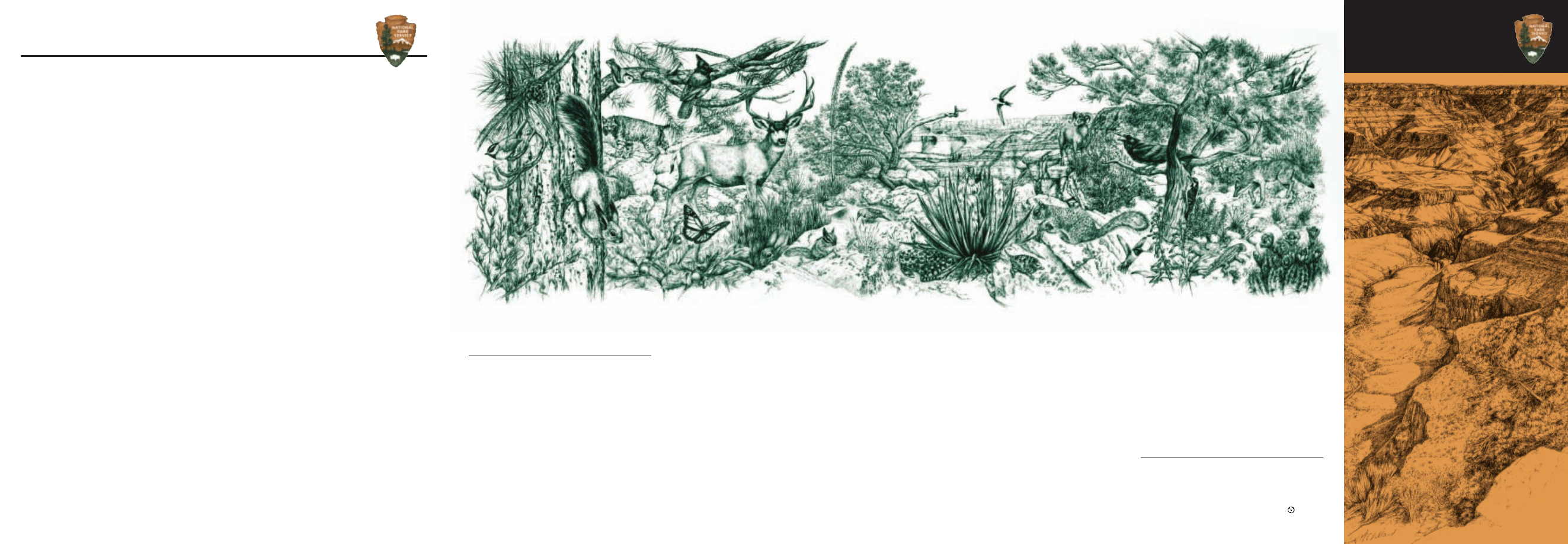
The plants and animals described here are common
throughout the South Rim and may be seen wherever you
choose to walk along the Rim Trail. There are no numbered
stops to follow. Use caution near the edge—humans are
among the less surefooted creatures at Grand Canyon.
The tallest tree on the South Rim is the ponderosa pine.
It has an extensive root system to acquire as much moisture
as possible. Stiff competition for water results in an open,
park-like forest. The bark on young trees is dark (hence the
name “black jack” often applied to younger ponderosas),
but by the time ponderosa pine trees mature, the bark is cin-
namon in color and smells faintly of vanilla. This is the only
long-needled pine in the park.
Wherever you see ponderosa pines, look for evidence of the
Abert squirrel. It is one of two varieties of tassel-eared
squirrels found in the park—the other being the Kaibab
squirrel, found only on the North Rim. Both are entirely
dependent upon ponderosa pines for food and habitat.
Scattered among the trees are a variety of drought-resistant
shrubs. In late spring and early summer you will likely
smell cliffrose before you see it. A member of the rose
family, this evergreen shrub produces fragrant cream-colored
flowers. These blossoms give way to seeds whose feathery
white plumes allow the wind to scatter them some distance.
Also common here is the banana yucca, one of the most
common and useful plants in the American Southwest.
Native Americans have traditionally used it in the manufac-
ture of soap, as a source of fiber for rope and sandals, and
for its edible fruits that resemble small bananas.
The mountain chickadee and the nuthatches are
small, acrobatic birds common in these coniferous forests.
The mountain chickadee is easily recognized by its black bib
and the white stripe over its eye. Gleaning insects from the
outer branches of conifers, this small bird will often hang
upside down in search of insects. The nuthatch similarly
uses its slender bill to search for insects in the bark of trees,
but it is unusual in that it will scurry down a tree headfirst.
Only the most observant and cautious hikers are likely
to see the bobcat, a shy creature who frequents the
North and South Rims but is rarely seen. Mule deer, on
the other hand, are among the most readily seen mammals
on the South Rim. Surefooted and nimble, they travel in
and out of the canyon with ease as food and water dictate.
The earliest trails into the canyon were likely built along
deer paths. Mule deer are readily distinguished by their
large ears.
The coyote is relatively common and ranges throughout
the park from rim to river, but you must be alert to spot
one. This close relative of the domestic dog is primarily noc-
turnal; their late night or early morning howls are among
the most distinctive songs of the canyon region. Their diet
consists mainly of rodents and insects.
At elevations below 7,000 feet/
2,100 meters the pinyon
pine and Utah juniper become the dominant members
of the South Rim forest. The short-needled pinyon is prized
for its edible seeds. The juniper, with its shaggy bark, is par-
ticularly well adapted to this arid climate: leaves have been
reduced to scales covered by a waxy cuticle, both of which
reduce water loss and insulate the tree against extremes of
temperature. Many of these gnarled trees are a good deal
older than they look. Both trees grow slowly in this arid cli-
mate, and many of them are over 200 years old. Clumps of
dwarf mistletoe are common in conifers throughout the
forest. This parasitic plant draws nutrients and water from
its host tree.
Although many people expect to encounter poisonous
snakes at Grand Canyon, the handsome gopher snake is
the only snake you are likely to see on the rim. A non-poi-
sonous predator, it mimics the threatening behavior of poi-
sonous species, but kills its prey by squeezing it until it suf-
focates. Most of the water this snake needs is obtained from
the rodents it consumes.
Among the reptiles commonly seen along the rim are
eastern fence lizards. Look for a blue patch on either
side of their throat. They prefer open, rocky areas along the
rim and, like most reptiles, are very well adapted to arid
environments.
While standing on the rim, listen for the “whoosh” of
white-throated swifts and violet-green swallows.
Swift, agile fliers, they dive through the air in relentless pur-
suit of insects. The large black bird commonly seen perched
along the rim or soaring above the canyon is the raven.
Larger than crows, these birds are extremely intelligent and
mimic a wide variety of animal noises.
Among the largest hoofed mammals in the park are the
desert bighorn sheep, but they are relatively scarce
along the rim, preferring the rocky slopes of the inner
canyon. They do not shed the long, curved horns that con-
tinue to grow throughout their lives. Like many mammals of
the region, they are likely to be found near reliable sources
of water: springs, seeps, or pools of summer rain.
In developed areas along the rim rock squirrels have lost
their natural fear of humans and are often seen begging for
handouts. It is dangerous and illegal to feed them. Do not
offer them food!
The bright red claret cup is the more common of two
species of hedgehog cactus at Grand Canyon. At lower
elevations its showy red blooms appear in April. Here on the
rim it favors the sunny, warm areas on the canyon’s edge
(blooming in May or June) and gives one a hint of the diver-
sity and beauty that await those who venture beyond the
world of the South Rim into the inner canyon.
Published by Grand Canyon National Park in cooperation with
Grand Canyon Association. Written by National Park Service Staff;
Tom Pittenger, NPS Editor; Ron Short, GCA Art Director.
Copyright 2001 Grand Canyon Association, Post Office Box 399,
Grand Canyon, AZ 86023. Printed on recycled paper.
Life Along the Rim
Grand Canyon National Park
1. Mountain Chickadee, 2. Ponderosa Pine, 3. Tassel-eared Squirrel, 4. Scrub Oak, 5. Bobcat, 6. Nuthatch,
7. Monarch Butterfly, 8. Steller’s Jay, 9. Desert Cottontail, 10. Mule Deer, 11. Cliff Chipmunk, 12. Utah Agave,
13. Red Shafted Flicker, 14. Pinyon Pine, 15. Gopher Snake, 16. Banana Yucca, 17. White-throated Swift,
18. Short-horned Lizard, 19. Rock Squirrel, 20. Desert Bighorn, 21. Black-chinned Hummingbird, 22. Raven,
23. Utah Juniper, 24. Hairy Woodpecker, 25. Northern Plateau Lizard, 26. Coyote, 27. Claret Cup Cactus,
28. Pinyon Jay. Illustration by Elizabeth McClelland.
2
2
2
2 ..
.
.
3
3
3
3 ..
.
.
4
4
4
4 ..
.
.
6
6
6
6 ..
.
.
7
7
7
7 ..
.
.
8
8
8
8 ..
.
.
9
9
9
9..
.
.
1
1
1
10
0
0
0 ..
.
.
1
1
1
11
1
1
1 ..
.
.
1
1
1
12
2
2
2 ..
.
.
1
1
1
14
4
4
4 ..
.
.
1
1
1
15
5
5
5 ..
.
.
1
1
1
16
6
6
6 ..
.
.
1
1
1
18
8
8
8 ..
.
.
1
1
1
17
7
7
7 ..
.
.
1
1
1
19
9
9
9 ..
.
.
2
2
2
2 0
0
0
0 ..
.
.
2
2
2
2 2
2
2
2 ..
.
.
2
2
2
2 3
3
3
3 ..
.
.
2
2
2
2 5
5
5
5
..
.
.
2
2
2
2 4
4
4
4 ..
.
.
2
2
2
2 6
6
6
6 ..
.
.
2
2
2
2 7
7
7
7 ..
.
.
2
2
2
2 8
8
8
8 ..
.
.
2
2
2
2 1
1
1
1 ..
.
.
1
1
1
13
3
3
3 ..
.
.
5
5
5
5 ..
.
.
1
1
1
1 ..
.
.
National Park Service
U.S. Department of the Interior
Grand Canyon National Park
North Rim
Grand
Canyon
Geology
Wyszukiwarka
Podobne podstrony:
grand canyon skywalk
Edukacja a stratyfikacja
Mobilność i straty składników nawozowych
Straty ciepla pomieszczen k
Levy J Grand Russian Fantasie
P w5 5.11, Studia (Geologia,GZMIW UAM), I rok, Paleontologia ze Stratygrafią, 1. PALEONTOLOGIA WYKŁA
straty lokalne, STUDIA BUDOWNICTWO WBLIW, hydraulika i hydrologia
Zyski i straty ciepla w miesiacach
Rozliczanie straty podatkowej przez podatników CIT
straty lokalne
Kilowaty nie na straty
63 SC DS300 R JEEP GRAND CHEROKE A 05 XX
09 Monopol straty i korzysci społeczne Ustawodawstwo antymonopolowe
SYSTEMATYKA paleo 2013, Studia (Geologia,GZMIW UAM), I rok, Paleontologia ze Stratygrafią
Tabela stratygraficzna, Nauka, Geografia
więcej podobnych podstron