
Land in Landscapes Circum Landnám: An Integrated Study of
Settlements in Reykholtsdalur, Iceland
Guðrún Sveinbjarnardóttir
1,3
, Ian A. Simpson
2
, and Amanda M. Thomson
2
Abstract - The initial settlement of Iceland in the 9th and 10th centuries AD was based on animal husbandry, with an em-
phasis on dairy cattle and sheep. For this activity, land resources that offered a range of grazing and fodder production
opportunities were required to sustain farmsteads. In this paper, the nature of land within the boundaries of settlements in
an area of Western Iceland centered on Reykholt, which became the estate of the writer and chieftain Snorri Sturluson in the
13th century, is analysed with a geographical information systems (GIS) approach. The results, combining historical, ar-
chaeological, and environmental data with the GIS-based topographic analysis, suggests that, although inherent land
qualities seem to have played a part in shaping the initial hierarchy of settlement in the area, it was the acquisition of
additional property and of access to resources outside the valley that ultimately pushed Reykholt to the forefront in the
hierarchical order.
1
Institute of Archaeology, University College London, 31-34 Gordon Square, London WC1H OPY, UK.
2
School of
Biological and Environmental Sciences, University of Stirling, Stirling FK9 4LA, Scotland, UK.
3
Corresponding author
- gudrun.s@ucl.ac.uk.
Introduction
Land—its quality, organization, and man-
agement—is an aspect of society-environment
relationships that has received little attention
until recently in studies of landnám (translated
as “land-take”), the period of initial settlement
and colonization of Iceland which, according to
Íslendingabók (The Book of Icelanders)
1
and sup-
ported by archaeological discoveries, took place in
the 9th and 10th centuries AD (Benediktsson 1996,
Sveinbjarnardóttir 2004, Vésteinsson 1998)
.
Land
organization in southern and western Norway during
the Viking and Early Middle Ages, around the time of
the Icelandic landnám, was characterised by manor-
type estates controlled by a small elite and with a
larger dependent group retained to work the estate
(Stylegar 2002). Similar estates are thought to have
emerged in Orkney and Shetland (the Northern Isles)
during the Viking Age and Later Medieval Period
(Crawford and Balin-Smith 1999, Steinnes 1959).
Since Iceland was settled largely from Norway via the
Northern Isles, it seems fair to assume that a similar
type of land organization was also introduced to Ice-
land with settlement. Written sources, archaeological
surveys, and excavations indicate that the settlement
pattern in Iceland was that of individual farmsteads
placed at even intervals on the best farming land, with
households consisting of a single or several families
(Sveinbjarnardóttir 1992, Vésteinsson 1998), similar
to today’s rural settlement pattern. Supporting zooar-
chaeological evidence, coupled with remains of ani-
mal houses, indicates that subsistence strategies from
the outset were largely geared towards a reliance on
domestic livestock, initially with the main emphasis
on dairy cattle, and then increasingly on sheep (e.g.,
Amorosi 1996, Hermanns-Auðardóttir 1989).
Appropriate land resources and their use at
different times of the year were an essential re-
quirement to support these activities (Vésteinsson
et al. 2002). An understanding of the attributes and
signi¿ cance of land during colonization and settle-
ment is therefore vital if we are to recognize the
way in which land resources were used to create
and maintain social structures. Despite an implicit
acknowledgment of the signi¿ cance of this, there
has been little attempt to characterize and explain
the role land qualities played during the emergence
of the early Icelandic cultural landscape. One aim of
this paper is to attempt to establish whether land at-
tributes inÀ uenced the initial settlement process and
its further development, and what this inÀ uence may
tell us about social organization in early Iceland.
The study area is centered on the Reykholt
estate in Reykholtsdalur, western Iceland,
at 21º17'W, 64º40'N, which has been the fo-
cus of the multidisciplinary Reykholt project
(www.snorrastofa.is). Extensive archaeological in-
vestigations have been carried out at the Reykholt
site (e.g., Sveinbjarnardóttir 2005b, 2006). The
area is delimited by the Hvítá River to the north
and the Reykjadalsá River and Steindórsstaðaöxl
and adjoining hills to the south (Figs. 1 and 2) and
covers 105.6 km
2
. It is 21 km from west to east
and 8.5 km at its widest point north to south.
The area was featured in a recent study of the
politics and development of early settlement pat-
terns in Iceland (Vésteinsson et al. 2002), where
settlements were divided into three categories based
on environmental type and access to resources. This
division into settlement types forms the basis for
the topographical analysis discussed in this paper.
The model is also put to the test, and the question
of why Reykholt became the most important and
2008
1:1–15
Journal of the North Atlantic
Journal of the North Atlantic
Volume 1
2
wealthiest farm in the valley in the medieval period
is explored. To achieve our aims, we place topo-
graphical (geographical information systems [GIS]
based) analyses into a thoroughly researched his-
torical (documentary source based), archaeological
(excavation and survey based) and environmental
(palaeoenvironmental studies based) context from
the Reykholtsdalur area.
Historical analyses
According to the Book of
Settlements (Landnámabók
2
)
and Egil’s Saga
3
, the area under
consideration formed part of the
huge land-take of the chieftain
Skallagrímr, one of the earliest
settlers in Iceland (Benediktsson
1968:71, Nordal 1933:73–74).
He soon gave or sold chunks
of this land to other settlers, in-
cluding one who took the tongue
of land between the rivers Hvítá
and Reykjadalsá, approximat-
ing the study area, and who
lived at Breiðabólstaður (13 on
Fig. 2; Benediktsson 1968:74).
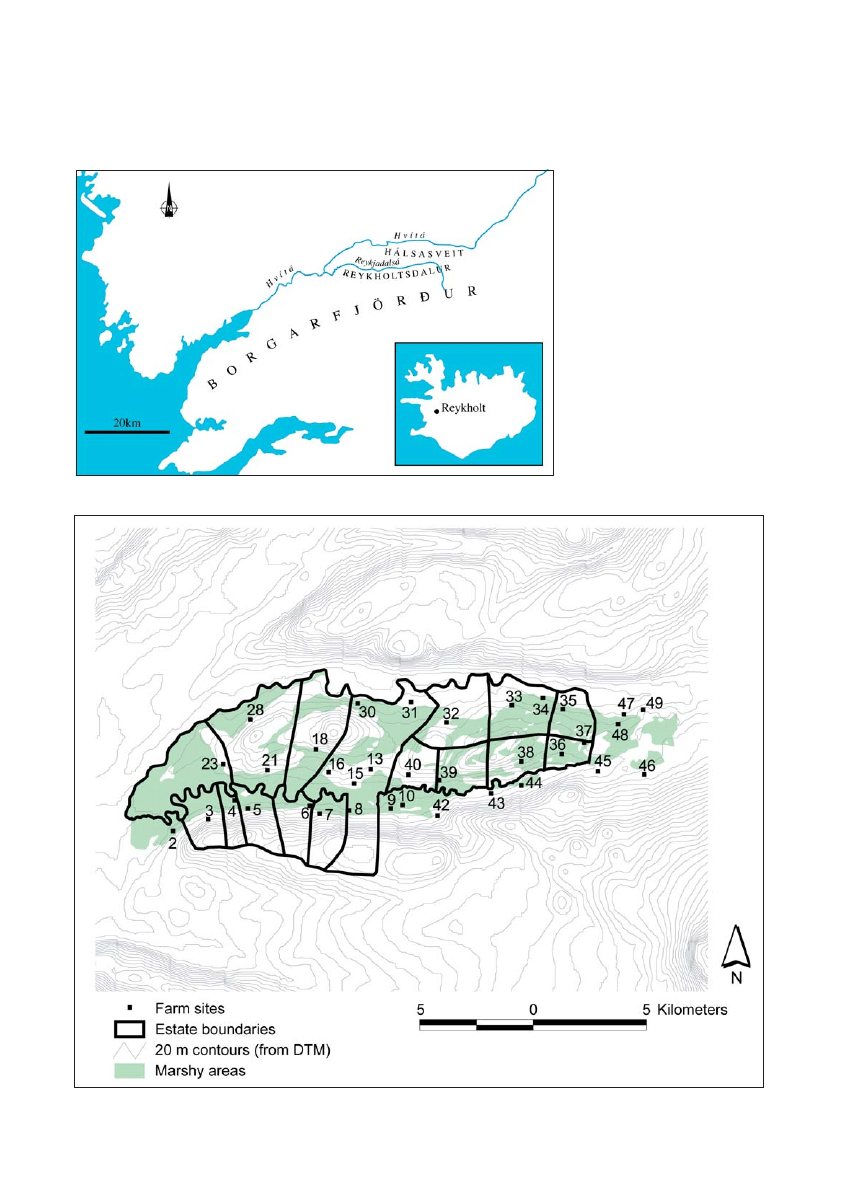
Figure 1. Location of Reykholtsdalur, western Iceland.
Figure 2. Farm locations and settlement boundaries in the Reykholt region.

G. Sveinbjarnardóttir, I.A. Simpson, and A.M. Thomson
2008
3
The land in the valley which lies to the south of the
Reykjadalsá river formed part of the holdings of
two other initial settlers according to Landnámabók
and is divided by the gorge Rauðsgil, by which one
of them lived (42 on Fig. 2); the other lived in the
adjoining valley further south. During subsequent
partitioning into farms, this land was divided into
a number of holdings, several of which became
the property of Reykholt at different times and are
therefore included in this study. Our sources for this
partitioning of the land are written sources of 12th
century date and later, and some archaeological
data (Table 1). Despite this lack of direct informa-
tion about the settlements in the valley before the
12th and 13th centuries, a number of inferences can
be made about the earlier settlement history.
The early establishment of the majority of the
farmsteads included in this study is supported by
indications supplied by the place-name evidence.
Of the thirty-four farms (Table 1), twenty have
topographic names (thought to be a sign of old
age), twelve end in –staðir (a common ending and
thought to point to early, important, but secondary
farms [Fellows-Jensen 1984:154, 159]), and one
suggests a lower status farm (Háfur [30], translated
as pocket net, indicating that ¿ shing in the Hvítá
river was practiced at this location). The –bólstaður
element of what, according to Landnámabók, was
the initial farm in the area, Breiðabólstaður (13), is
common in Western Norway (Olsen 1928) and the
Northern Isles, where it seems to have been active
from the beginning of the Viking Age until well into
the Medieval Period (Gammeltoft 2001).
Breiðabólstaður (13) is, as already mentioned,
named in Landnámabók as the farm of the earliest
settler in the area. Reykholt (15) is mentioned by
name in Landnámabók as a place attended for baths
by the inhabitants of Breiðabólstaður and again as
the residence of Þórður Sölvason who lived in the
11th century (Benediktsson 1968:78–9). Archaeo-
logical investigations at Reykholt have produced
10th- to 11th-century dates on barley grains for the
earliest occupation (Sveinbjarnardóttir et al. 2007).
A church, the excavation of which was completed
in 2007, seems to have been erected at Reykholt in
the 11th century
4
or shortly after the introduction of
Christianity in about A.D. 1000. It has been sug-
gested that Reykholt had already become a church
center (staður) by the early 12th century (Þorláksson
2000). It now seems clear that a church had been
established there well before that time. On the basis
of the above evidence, it is concluded that Reykholt
had been established by c. A.D. 1000 and that it was
an important site from the outset.
One indication of this early importance is the
fact that by about 1200 the initial farm in the area,
Breiðabólstaður (13), belonged to Reykholt, to-
gether with the neighbouring farms Hægindi (8)
and Norðurreykir (31), with the cottage Háfur (30)
being in the care of the church farmer. The earliest
preserved charter listing the property of the church at
Reykholt is a single sheet of calfskin thought to have
been written over the period from the second half of
the 12th century until c. 1300 (Gunnlaugsson 2000).
The above-mentioned property is not mentioned in
the earliest part of the charter, which is dated to the
1180s. On the other hand, the homeland and exten-
sive rights and privileges in various more distant
locations, for grazing, shieling activity, woodland,
and driftwood collection, are listed there (Sveinbjar-
nardóttir 2005b, in press). Grímsstaðir (16), which
had become the property of the Reykholt church by
1463, is mentioned in the 13th-century Sturlunga
saga, but the nature of the farm at that time or its earli-
est history is unknown. In the topographical analysis,
it is combined with the land of the Reykholt estate,
thus giving the 16th-century picture of its size.
Skáney (18), Sturlureykir (21), and Deildartunga
(23) are regarded as having been next in importance.
This determination is based on the value of the land
they occupied and the fact that all had annex churches
in the past, which, based on patterns elsewhere in the
country, is an indication of an independent farm estab-
lished early in the settlement process (Vé-steinsson
1998). Hurðarbak (28) is mentioned in the 13th-cen-
tury Sturlunga saga, but nothing is known about the
nature of the farm at that time or its earliest history.
Steindórsstaðir (10), which seems to have had an an-
nex church in the past and lies just outside the study
area, also falls into this category.
Along the same lines of inquiry, the remaining
12 settlements within the study area are less im-
portant and most only had one farm. They are all
mentioned in early sources and are all believed to
have been established as secondary farms, although
we do not know exactly when or in what order. Háls
(37) in the land of Kolslækur (36), together with
Vatn (49), in the land of Stóri Ás (47), which lies
just outside the study area, were abandoned in the
13th or 14th century. Archaeological investigations
have been carried out at Háls, which was never
reoccupied (Smith 1995). Research suggests a 10th-
century date for the earliest habitation at the site and
an indication that the locale was used as an iron-ex-
traction site in the 9th or early 10th century, before
it became a farm. The research also indicated that
the area occupied by Kolslækur/Háls (36/37), Sig-
mundarstaðir (35), Refsstaðir/Bolastaðir (33/34),
and Signýjarstaðir (32) was covered with forest
or brushwood in the past. There is a reference in a
place-name survey for Refsstaðir (The Árni Magnús-
son Institute for Icelandic Studies–The Place-Name
Collection. Hálsasveitarhreppur 3509. Refsstaðir)
to charcoal-making in the past in this area which

Journal of the North Atlantic
Volume 1
4
lies on the border between the two church seats and
large estates, Reykholt and Stóri Ás. The stretch
along the Hvítá River, between Stóri Ás (47) and
Norðurreykir (30), suffered bad erosion in the past,
Table 1. Earliest settled farms in the Reykholtsdalur area.
No.
Earliest
Date
on
written
(year or
Church /
map Site name
source
century)
chapel
References and other information
3 Hamrar
Deed
1380
DI 3:351-2.
Chapel?
Oral tradition. Pétursdóttir 2002:85.
4 Kleppjárnsreykir
Heiðarvíga saga 12th
5 Snældubeinsstaðir Sturlunga saga
13th
6 Kjalvararstaðir
Landnáma
12th
Charter
1358
DI 3:122–3. Owned by Reykholt.
7 Kópareykir
Landnáma
12th
Charter
1463
DI 5:399–400. Owned by Reykholt.
10 Steindórsstaðir
Charter
c. 1185
Chapel
DI 1:280. Christian graves found.
Byggðir Borgarfjarðar II:293.
9 Vilmundarstaðir
Deed
1550
DI 11: 779, 785.
13 Breiðabólstaður
Landnáma
12th
Settlement farm
Charter
1206
DI 1:471. Part of Reykholt estate.
15 Reykholt
Landnáma
12th
Archaeological date: 10th–12th century.
List of priests
1143
Parish church DI 1:188–89. Páll Sölvason lived at Reykholt.
charter
1180s
DI 1: 279–280.
List of churches c. 1200
DI 12:10.
Sturlunga saga
13th
8 Hægindi
Charter
1206
DI 1:471. Part of Reykholt estate.
31 Norðurreykir
Charter
1206
DI 1:471. Part of Reykholt estate.
30 Háfur
Charter
1206
DI 1:471. Part of Reykholt estate.
16 Grímsstaðir
Sturlunga saga
13th
Charter
1463
Owned by Reykholt
18 Skáney
Landnáma
12th
11th century brooch found in home ¿ eld.
Charter
1367
Annex church DI 3:222. Human bones found in home ¿ eld.
Þórðarson 1936:44–45.
21 Sturlureykir/
Deed
1463
Annex church DI 5:400.
Gullsmiðsreykir
28 Hurðarbak
Sturlunga saga
13th
23 Deildartunga
Deed
1178
DI 1:189.
Annex church Priest living at farm. Vésteinsson 2000b:98.
32 Signýjarstaðir
Landnáma
12th
34 Refsstaðir
Charter
1258
DI 1:593–4.
33 Bolastaðir
Charter
1590
AI II:204. Lay abandoned in 1590.
35 Sigmundarstaðir
Landnáma
12th
36 Kolslækur/
Landnáma
12th
37 Hálsar
Heiðarvíga saga
12th
Archaeological dates: mid-10th–late 13th century.
38 Uppsalir
Deed
1563
DI 15:157.
39 Hofstaðir
Landnáma
12th
40 Úlfstaðir
Landnáma
12th
42 Rauðsgil
Landnáma
12th
Settlement farm.
43 Búrfell
Deed
1563
DI 15:157.
44 Auðsstaðir
Landnáma
12th
47 Stóri Ás
Landnáma
12th
Settlement farm.
Charter
1258
Parish church DI 1:593–4.
49 Vatnskot
Charter
1258
DI 1:593–4. Abandoned in 13th century.
45 Giljar
Charter
1258
DI 1:593–4.
46 Augastaðir
Charter
1258
DI 1:593–4.
48 Hraunsás
Landnáma
12th
Charter
1463
DI 5:399–400. Half owned by Reykholt.

G. Sveinbjarnardóttir, I.A. Simpson, and A.M. Thomson
2008
5
probably largely as a result of over-exploitation of
the woodland.
It is clear from the above survey that the avail-
able sources cannot give an accurate picture of land
division in the study area at the time of settlement.
Human activity has only been archaeologically
dated at two sites, Reykholt and Háls, to c. A.D.
1000 and the late 9th centuries, respectively. The
earliest references to the other farms marked on the
map in Figure 2 are of 12th- and 13th-century dates
and later, which is, therefore, the true time period
reÀ ected in the topographical analysis presented be-
low. This settlement division is likely to go back to
earlier times, although this cannot be proven.
On the above basis, 16 land holdings are identi-
¿ ed in the study area (Fig. 2) that can be considered
as having been settled during the ¿ rst centuries of
farm establishment. Some of these holdings con-
tained more than one farm from early on (Table 1).
Several dependent farms are mentioned in sources
from the Later Medieval/Early Modern Period as
having been established on the larger holdings, some
of which were only occupied for a short period of
time. The earliest reference to most of these is in an
early 18th-century land survey (Jarðabók 1925 and
1927), although some may well be earlier.
The boundaries for the different land holdings
used in this study and illustrated in Figure 2, are
the ones used in Vésteinsson et al. (2002). They
are largely based on the 19th/early 20th century
Landamerkjabók, which is a collection of bound-
ary documents of individual holdings compiled for
the sheriff of the area and still serves as the basis
for present property divisions. Other sources that
can throw light on earlier boundary lines are the
previously mentioned Landnámabók, which gives
some landmarks, medieval documents published
in the Diplomatarium Islandicum (DI) series, and
cartographic and ethnographic sources. Some of the
boundary-lines are more permanent than others and
therefore likely to have been in place unchanged
through the centuries, such as gorges, large boul-
ders used to de¿ ne line-of-sight limits, and the river
course at the valley bottom, although this has clearly
shifted somewhat through the centuries; others are
less permanent and therefore less reliable, such
as cairns and earthworks. Historically, the main
settlements seem to have been stable through the
centuries. On that basis and with due reservations,
these predominantly recent boundary lines are used
retrospectively to reÀ ect much earlier times.
The numbers in Figure 2 are the same as those
in Table 1, referring to the farmsteads on each
holding thought to have been occupied in the
first centuries of settlement. In the table, they are
grouped accordingly.
Archaeological and Palaeoecological Data
Archaeological survey has been carried out
in most of the study area (Pétursdóttir 2002;
Vésteinsson 1996, 2000a). A result that is of par-
ticular importance for this discussion is the apparent
stability of the farmhouse locations until very recent
times. In most cases, the present dwelling house has
been built on top of the old farm-mound, inevita-
bly causing severe damage to any older remains.
At about a third of the sites, the dwelling has been
moved down slope, to the valley bottom, but this
only happened around the middle of the last century.
It was also at that time when tremendous changes
took place in farming methods that until then seem
to have been to a large extent unchanged since the
beginning of settlement. Machines were for the ¿ rst
time used to dig drainage ditches, and large areas
were turned into ¿ elds, mostly for the cultivation of
grass used to feed the domestic animals on which the
Icelandic farming economy has always been based.
Prior to this expansion in activity, only a small area
around the farm had been levelled by hand and cul-
tivated, creating the in¿ eld, which was usually sur-
rounded by an enclosure. These old in¿ eld areas at
individual farms were planned in the ¿ rst quarter of
the 20th century, and the plans (túnakort) are kept in
the National Archives of Iceland in Reykjavík. The
fact that there was little change in farm locations
and the size of cultivated areas until after the middle
of the 20th century suggests that these plans give a
good picture of what the individual farms may have
been like physically in much earlier times.
Palaeoecological analysis was a part of the
archaeological excavations at Reykholt (Svein-
bjarnardóttir et al. 2007), and such investigations
have also been carried out in the vicinity of the site
(Gathorne-Hardy et al., in prep.). Pollen, insect, and
plant macro-analyses indicate that the main environ-
mental change in the valley after settlement was in
the woodland that covered the area, particularly the
higher slopes. Although there was a decline in the
woodland immediately after the initial settlement
period, as indicated by the landnám tephra layer
(dated to 871 ± 2 AD; Grönvold et al. 1995), it was
¿ rst drastically reduced between c. A.D. 1150 and
1300. Today the area is devoid of trees. Soils-based
evidence suggests an increase in soil wetness as-
sociated with this phase of vegetation cover change
(I. Simpson, unpubl. data). Some cereal was grown
locally during the initial period of habitation, but
by the 13th century there is no evidence of this in
the pollen record (Erlendsson 2007). These ¿ ndings
are supported by the written sources which men-
tion cereal cultivation at the site in the 1180s and
1224 charters (DI 1, 280, 471), but not in the 1358
charter (DI 3, 122–3). Neither shift seems to have
been linked to climatic deterioration, since climate

Journal of the North Atlantic
Volume 1
6
appears to have been fairly stable until c. 1400, when
temperatures were brought down by c. 1 °C (Gath-
orne-Hardy et al., in prep.). Rather, these changes
appear to have been the result of, on the one hand,
over-exploitation of the woodland and on the other, a
management decision on cereal cultivation. A reduc-
tion in the availability of wood as fuel led to an in-
crease in the use of peat and animal dung. This shift
may have had the result that less dung was available
as manure, resulting in lowered soil fertility.
Soils reÀ ect the environment in which they have
been formed. By using techniques such as thin sec-
tion micromorphology of undisturbed soil samples
and total phosphorus analyses of bulk samples, in-
terpretations about their management and historic
environments can be made. Such analyses have been
undertaken on soil samples from the home ¿ elds at
Breiðabólstaður, Grímsstaðir, and Reykholt, all con-
tained within the boundaries of the Reykholt estate
by the 15th century (I. Simpson, unpubl. data). In thin
section, evidence of cultural amendment of the soil is
expressed in traces of micron-scale bone fragments,
peat ash residues, ¿ ne charcoals, and cut marks at-
tributable to cultivation. Evidence for amendment
is, however, slight, and consists of domestic debris
rather than the waste turfs and manures that are more
normally found where manuring of land is a major
land management strategy in the Norse North Atlantic
region (Simpson 1997). The identi¿ cation of animal
manures and a range of fuel wastes in the midden at
Reykholt suggests that material that could have been
applied to the home ¿ eld was instead deposited as part
of the midden close to the farm houses (Sveinbjar-
nardóttir et al. 2007). Total phosphorus levels are low
(ranging from 135–220 mg/100 g), again suggesting
limited soil amendment.
These observations suggest that in all the home
fields associated with the Reykholt estate, little ef-
fort was made to maintain or enhance home-field
soil fertility. Cereal production was unlikely to be a
major aspect of land management in the home field,
with inherent land fertility or importing of hay from
meadows relied on for winter fodder. This soils-
based evidence from Reykholt is in marked contrast
with that from the ecclesiastical power center of the
Bishop’s seat at Skálholt, where there is evidence
of heavy amendment of the home field from its
earliest phases of formation (I. Simpson, unpubl.
data). This comparison opens up the possibility of
contrasting land management strategies between
different power centers.
At Háls, further up the valley, palaeoecological
investigations undertaken in the home ¿ eld showed
that the area, now completely devoid of trees, was
covered with birchwood before the site became an
iron-extraction site in the late 9th and 10th centuries.
Logs of fully grown trees were found in deposits pre-
dating the landnám tephra layer, coupled with high
levels of birch pollen, which dropped dramatically
shortly after iron production began (Dixon 1997,
Smith 2005). These changes, as at Reykholt, were
associated with increases in soil wetness (I. Simp-
son, unpubl. data).
Topographical analyses
The three categories of early settlement recog-
nized in Reykholtsdalur and described above have,
were termed by Vésteinsson et al. (2002) as “large
complex settlements,” “large simple settlements,”
and “planned settlements.” A large complex settle-
ment is characterized by access to a wide range of
resources and by having a number of households in
residence. It was usually a political center, with a
parish church associated with it. Reykholt (15) fits
this category, as does Stóri Ás (47), just east of the
study area and belonging to another initial land-
take. Large simple settlements are characterized
as having a somewhat more limited and less-varied
resource base. They supported fewer households
than did large complex settlements, and usually
had a chapel or an annex church. Skáney (18), Stur-
lureykir (21), Deildartunga (23), and Steindórsstaðir
(10), which lies just outside the study area, fall into
this settlement category. In contrast, planned settle-
ments are characterized as occupying a small area,
and as a rule, supporting only a single household
(Tables 1 and 2). This classification formed the ba-
sis for the GIS-based topographical approach used
to define key bio-physical attributes of land asso-
ciated with the Reykholtsdalur settlements. These
attributes include elevation, aspect, slope, annual
insolation, summer insolation, and extent of marshy
areas;
5
size of land holdings and farm locations are
also included in the analyses. The land attributes
selected are not readily modified by human activity,
carry increased significance in view of the absence
Table 2. Settlement classes within the Reykholtsdalur area.
Name Area (ha)
Settlement class
Refsstaðir 668
Planned
Hamrar 425
Planned
Sturlureykir 1280
Large, simple
Hofsstaðir 434
Planned
Kolslækur 246
Planned
Kjalvararstaðir 396
Planned
Kleppjárnsreykir 203
Planned
Kópareykir 454
Planned
Reykholt 2036
Large, complex
Sigmundarstaðir 365
Planned
Signýjarstaðir 780
Planned
Skáney 935
Large, simple
Snældubeinsstaðir 421
Planned
Deildartunga 1068
Large, simple
Ulfsstaðir 383
Planned
Uppsalir 468
Planned

G. Sveinbjarnardóttir, I.A. Simpson, and A.M. Thomson
2008
7
of substantial evidence for land improvement, and
act as proxy indicators for a range of related land
attributes including seasonal and spatial patterns of
vegetation productivity and diversity.
Capture and projection of geographic data sets
The study area is covered by the 1:50,000 maps
5520 I (Lundur) and 5521 II (Northtunga) (Series
C762, 1948, American Army Map Service). The
map sheets from 1948 were based on the Universal
Transverse Mercator grid (Zone 27), International
1909 spheroid, with a horizontal datum based on the
Astronomic Station at Reykjavík (21º55'51.15"W,
64º08'31.88"N), which is no longer used. The trans-
formation to the Lambert/WGS84 projection was
carried out using information from the Land Survey
of Iceland website (http://www.lmi.is/landsurvey.nsf/
htmlPages/goproweb0190.html). This transformation
is a “best-¿ t” and does not give geodetic accuracy.
The eastern tip of the research area is covered by map
sheet 1714 III (Series C761, Defense Mapping Agen-
cy, 1977–1990). Settlement boundaries are taken
from the webpage of Nytjaland (http://eldur.lbhi.is/
website/nytjaland/viewer/htm) compiled by the Agri-
cultural University of Iceland, adapted on the basis of
the boundary sources mentioned earlier and overlain
on a 1913 map at 1:50,000 scale. Maps were scanned
and geo-referenced in Erdas Imagine 8.5,
6
and settle-
ment boundaries, farm locations and marsh areas
were digitized from the scanned maps in ARC/INFO.
7
The resultant data sets were then transformed in ARC/
INFO, so that their projection and datum matched
that of the digital terrain model (Table 3). Elevation
information for the area was supplied by a digital ter-
rain model based on 90-m grid cells (equivalent to 1:
50,000 scale). Slope and aspect topographic informa-
tion has been derived from this data set; the area and
proportional coverage of each elevation, slope, and
aspect class within individual settlement areas was
calculated from it as well.
GIS-based topographies
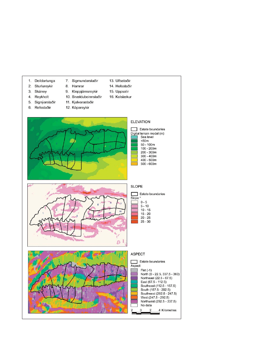
The Reykholtsdalur area has fairly gentle, low-
lying topography, and most of the settlement areas
lie below 150 m a.s.l. Slopes are relatively gradual,
being mostly <10º. The east–west orientation of the
region’s topography means that the greatest area of
land is either north or south facing; a very small
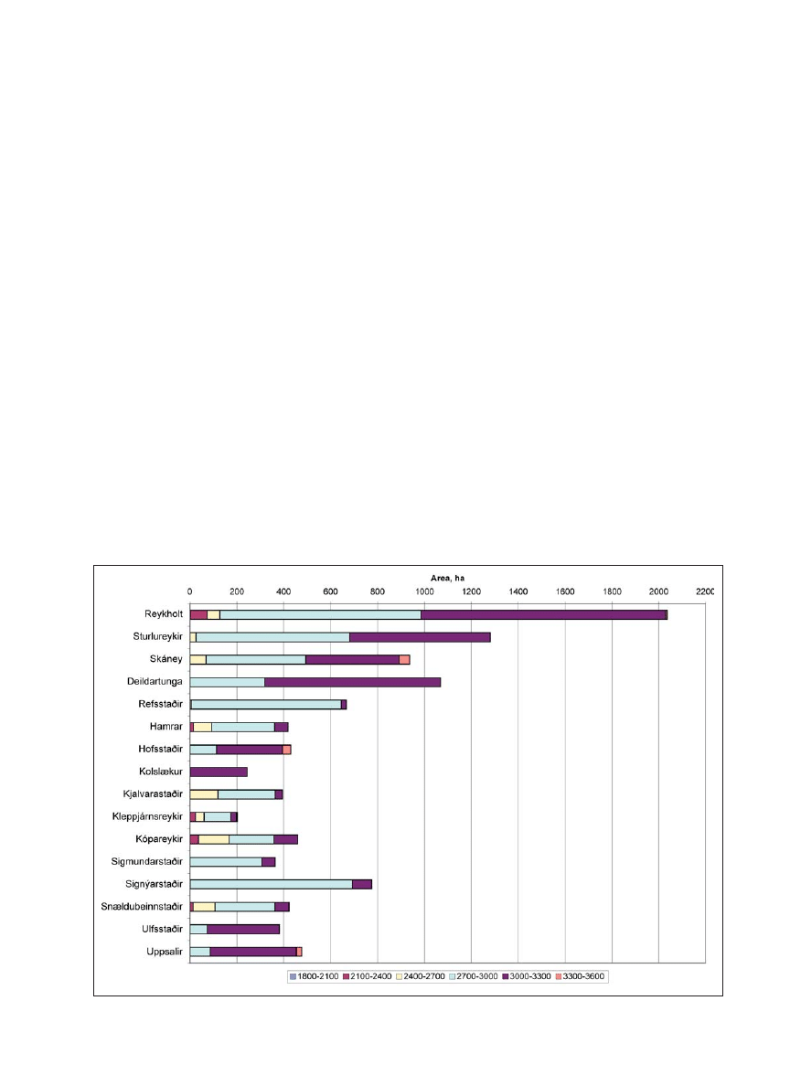
proportion of the area is totally À at (Fig. 3). Figure
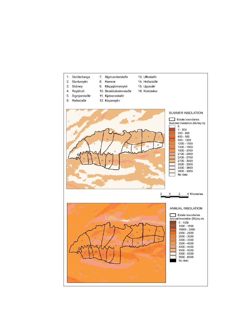
4 shows the relative spatial variation in annual and
summer insolation (the amount of solar radiation
received at the earth’s surface, although these values
may be greatly modi¿ ed by cloud cover and atmo-
spheric water content) for the region. The relatively
gentle slopes mean that there are subtle but not huge
variations in insolation across the area. Most of the
region receives between 3000 and 4000 MJ m
-2
an-
nually, and the bulk of this insolation is received in
the summer months (May–September), when most
areas receive between 2700 and 3300 MJ m
-2
. The
area of marshy land was digitized from the 1948
topographic maps, before large-scale drainage had
taken place in the region and indicates an area of c.
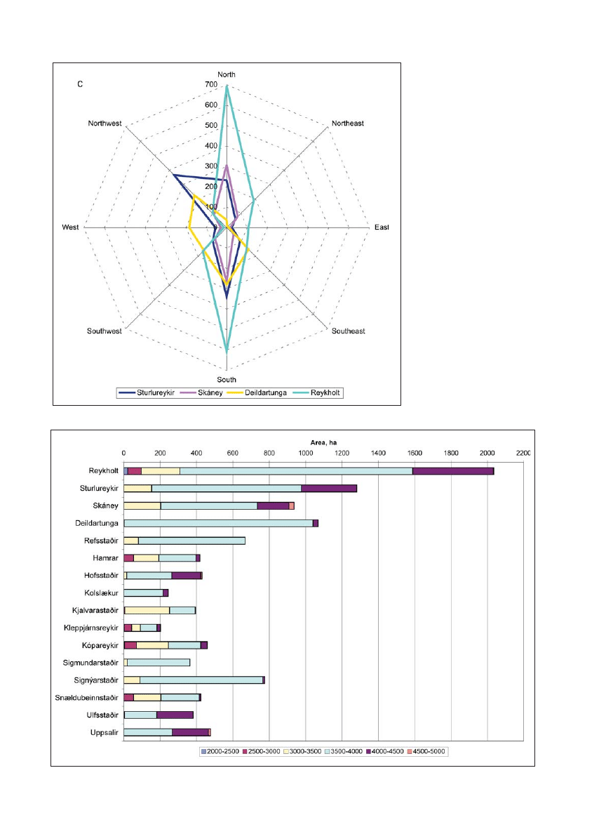
5203 ha. Figure 2 shows that there were consider-
able areas of marshy land on all the holdings in the
study area, covering at least 25% of the settlement
area, and up to 87% in one case (Table 4).
The Reykholt estate, characterized as a “large
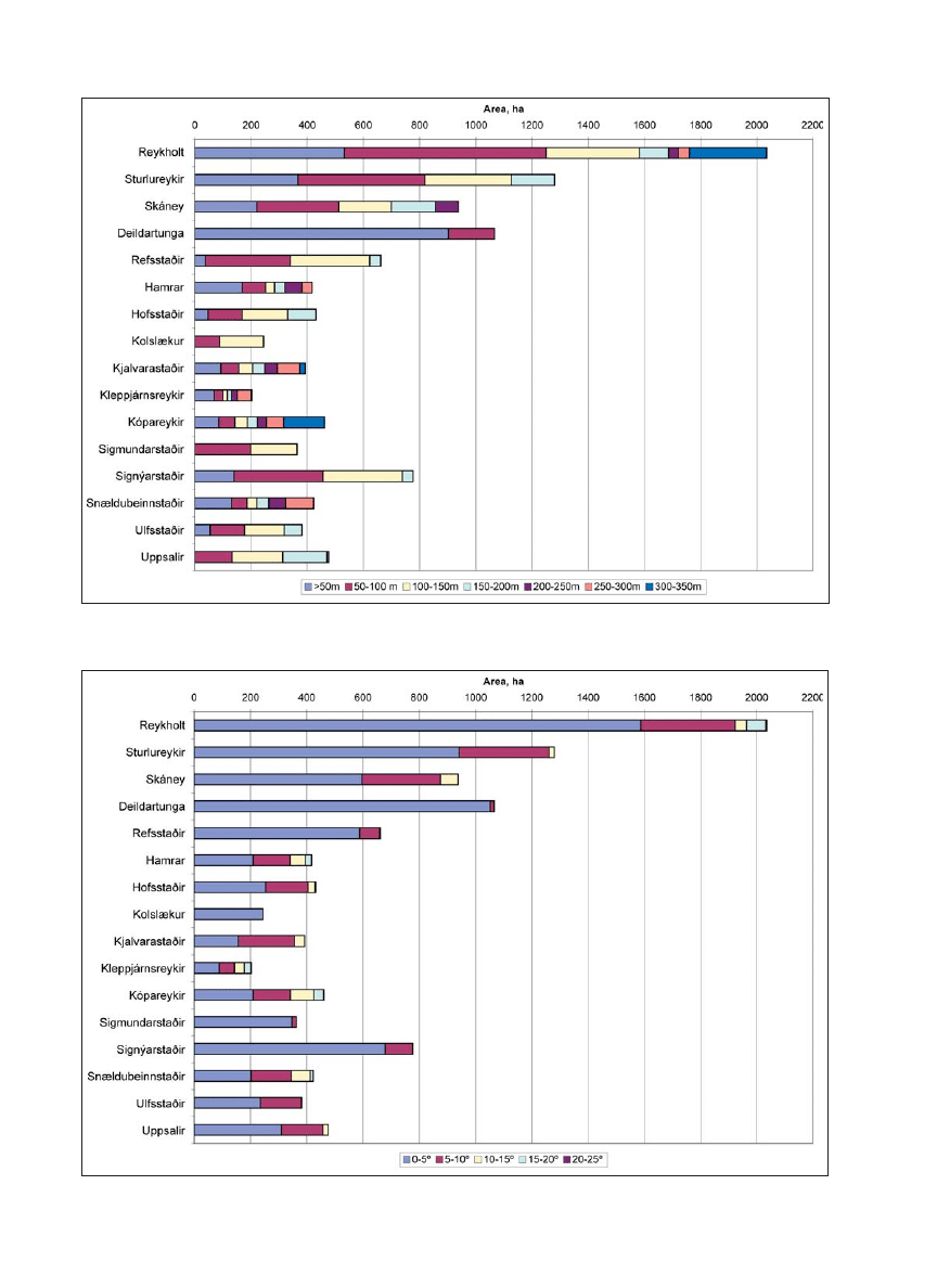
complex settlement,” displays a wide topographic
range within its boundaries. Elevation classes range
from c. 50–350 m, with the lower elevation ranges
dominant. Similarly, a range of slope classes are
also evident (0–c. 25°), with much of the area in the
range of 0–5°. Both north and south aspect classes
are dominant within the estate, since it stretches
across the whole valley and over the hill down to
the Hvítá River on the north side, but all aspect cat-
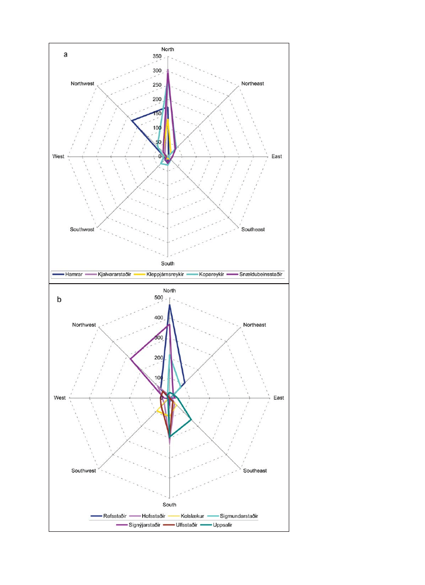
egories are represented (Figs. 5, 6, and 7c). Annual
insolation also has a considerable range, reÀ ecting
aspect and slope, from c. 2000–4500 MJ m
-2
, with
much of the insolation in the 3500–4000 MJ m
-2
category. Summer insolation reÀ ects the wide an-
Table 3. Projection information for geographic data sets.
Projection Lambert
Datum WGS84
Spheroid WGS84
Units Metres
1st standard parallel 64°15'0.000"
2nd standard parallel 65°45'0.000"
Central meridian -19°00'0.000"
Latitude of origin 65°00'0.000"
False easting 500000
False northing 500000
Table 4. Area and proportion of marshland on each
settlement.
Area of
% of farm area
Settlement marsh (ha)
that is marsh
Refsstaðir 422.1
63
Hamrar 186.2
44
Sturlureykir 571.6
45
Hofsstaðir 271.8
63
Kolslækur 179.7
73
Kjalvararstaðir 98.4
25
Kleppjárnsreykir 67.3
33
Kópareykir 114.3
25
Reykholt 970.9
48
Sigmundarstaðir 241.0
66
Signýjarstaðir 240.8
31
Skáney 409.8
44
Snældubeinsstaðir 141.0
34
Deildartunga 933.9
87
Ulfsstaðir 94.8
25
Uppsalir 259.1
55
Journal of the North Atlantic
Volume 1
8
nearly twice the size of the next largest, Sturlureykir,
classed as a ”large simple settlement,” and ten times
the size of the smallest settlement, Kleppjárnsreykir,
classed as a ”planned settlement.”
Three settlements within the study area, Stur-
lureykir, Skáney, and Deildartunga, are considered to
fall into the “large simple settlement” category, with
a size range of 935–1280 ha. These settlements also
accommodated additional farms at different times.
The topographic range
of these holdings is
more restricted in com-
parison with the “large
complex settlement;”
elevation range on these
three holdings is from
c. 50 to c. 250 m, with
slope classes ranging
from 0 to c. 15° and
with aspects that are
predominantly north,
northwest, and south
(Figs. 5, 6, and 7c). An-
nual insolation ranges
are similarly restricted,
although much of the in-
solation, as at Reykholt,
is in the 3500–4000 MJ
m
-2
category; similarly,
the summer insolation
range is restricted to
the 2700–3000 and
3000–3300 MJ m
-2
cat-
egories (Figs. 8 and 9).
Sturlureykir (45%) and
Skáney (44%) have
similar percentage ar-
eas of marshland within
the settlement bound-
ary, in marked contrast
to Deildartunga, which
has approximately
87% of its areas as
marshland, consider-
ably more than that of
Reykholt (Table 4). De-
ildartunga is also marked
by its topographical
simplicity, with the
least topographic range
of any of the settlements
within the study area.
The
twelve
smaller
settlements within the
study area, speci¿ ed as
“planned settlements,”
are characterized by a
nual range with MJ m
-2
values from c. 2100–3300
(Figs. 8 and 9). While the Reykholt estate has the
largest area of marshland, an important type of land
for collecting animal fodder, this type only made up
approximately 48% of the estate’s total land area
(Table 4). Reykholt has also, through the centuries,
accommodated the greatest number of farm sites
within its boundaries (Table 1). By the 15th century,
it is the largest land holding in the study area and is
Figure 3. GIS-based topographical analyses of elevation, slope, and aspect, Reykholtsdalur,
Iceland.
G. Sveinbjarnardóttir, I.A. Simpson, and A.M. Thomson
2008
9
is typically in the 3500–4000 MJ m
-2
class, although it
can range from 3000–5000 MJ m
-2
; summer insolation
is typically 2700–3000 MJ m
-2
(Figs. 8 and 9). Marsh-
land varies from 25–73% of settlement area (Table 4).
Discussion
The study area, a valley rising inland, c. 25 km
away from the sea, constitutes a typical Icelandic val-
ley well suited for farming. It is À anked by a series
size range that varies from 203–780 ha and typically
have only a single farm on their land. Based on size
and topographic data, these settlements can be divided
into two categories. The ¿ rst of these categories is
con¿ ned to the ¿ ve settlements in the south and west,
which are among the smallest in the study area (203–
454 ha), but have a wider topographic range than the
other “planned settlements” (Fig. 3, Table 2). These
elements typically include a full range of elevation
classes, from c. 50–c. 350 m, and, with the exception of
Kjalvararstaðir, slope
class ranges from
0–c. 20° and are pre-
dominantly northerly
and northwesterly in
aspect (Figs. 5, 6, and
7a). Annual insolation
ranges are typically c.
2500–c. 4500 MJ m
-2
,
but are predominantly
in the 3000–4000 MJ
m
-2
range; the sum-
mer insolation range
is in the 2700–3000
MJ m
-2
category (Figs.
8 and 9). Marshland
covers between 25
and 44% of these
settlement areas
(Table 4). The second
of the “planned settle-
ment” categories
is found within the
north and east part of
the study area (Fig. 2,
Table 2). These sites
are generally larger
in size (246–780 ha)
than the ¿ rst category
of “planned settle-
ments,” but with less
topographic diver-
sity. Here, elevation
classes range from c.
50–250 m. Although
more restricted at
Kolslækur and Sig-
mundarstaðir, slope
class ranges are typi-
cally from 0–10° with
predominantly north
and northwest aspects
and more limited
south and southeast
aspects (Figs. 5, 6, and
7b). Annual insolation
Figure 4: GIS-based summer and annual insolation, Reykholtsdalur, Iceland.
Journal of the North Atlantic
Volume 1
10
Figure 5. Area of settlement within each elevation class. The bar chart represents elevation classes in meters (m).
Figure 6. Area of settlement within each slope class. The bar chart represents slope classes in degrees (°).
G. Sveinbjarnardóttir, I.A. Simpson, and A.M. Thomson
2008
11
of long, gently sloping hills,
averaging about 270 m.a.s.l.
in height, with the most fertile
land lying closest to the river.
The valley opens out to the
west, where the most exten-
sive lowland area is, with soils
becoming thinner and less
productive further inland. The
area, including the Reykholt
estate, enjoys the additional
bonus of a number of hot and
warm springs that were used
by the inhabitants from early
on (Sveinbjarnardóttir 2005a).
Growing conditions will cer-
tainly have been enhanced in
the springs’ vicinity. On the
whole, but in particular in
the lower half of the valley, a
good range of land resources
for domestic livestock produc-
tion was available and a basis
for the local economy.
Although the details of the
earliest settlement process
cannot be precisely dated,
the topographic analyses
suggests that during the par-
titioning of Reykholtsdalur,
land resources were important
in the process, with the better
quality land being allocated
to the largest settlements
Skáney (18), Sturlureykir
(21), and Deildartunga (23)
lower down the valley. The
Reykholt estate, which had
taken over what is thought
to have been the initial
settlement farm, Breiðaból-
staður (13), by c. 1200,
is associated with a wide
topographic range indica-
tive of the widest range of
land resources in the area,
comparable to that belong-
ing to the initial occupant at
Breiðabólstaður. Crucially,
though, Reykholt gradually
acquired more land nearby
and had the use of woodland
areas and extensive moun-
tain pastures some distance
away from the home farm.
These pastures, accessed
during the summer months,
ensured a resilient economy
Figure 7. Areas within each aspect class: a) planned settlement, west, and b) planned
settlement, east. See next page for: c) large simple and large complex settlements.
Journal of the North Atlantic
Volume 1
12
based on a diverse land
resource base, and were
vital for the emergence
of Reykholt as a center of
power (Eyþórsson 2007).
It is significant that it is
the accumulation of land
area rather than the inten-
sification of land use that
contributes to this process.
The three “large simple
settlements” created as
part of the partitioning of
Reykholtsdalur, although
somewhat smaller than the
Reykholt estate and with
less topographical range,
did contain considerable
areas of marshland on river
banks in the valley bottom,
particularly towards the
lower, more fertile end of
the valley. These were the
best areas for winter fod-
der collection, always an
important part of Icelandic
farming. Winter fodder was
particularly important for
Figure 8. Area of settlement within each annual insolation class. The bar chart represents insolation class in MJ m
-2
.
Figure 7c. Areas within each aspect class: large simple and large complex settlements.
G. Sveinbjarnardóttir, I.A. Simpson, and A.M. Thomson
2008
13
The topographical analysis indicates that the in-
herent quality of land played a large role in the way
the initial large land-take, bordered by the two rivers
in the Reykholtsdalur valley, was partitioned. The
historical and archaeological evidence for Reykholt,
the central settlement in the valley, indicates that the
farm, which seems to have been established by c.
A.D. 1000 on the land of the initial settlement in the
valley, was a major farm from the outset, taking over
the land and leading role of the initial farm and in-
cluding several other farmsteads within its holding.
While the quality of the land belonging to the estate
is somewhat inferior for livestock production to that
of the three “large simple settlements” occupying
the prime land to the south of it, the estate made
up for this shortcoming and got steadily wealthier
through the acquisition of various land resources in
and outside the valley.
Conclusion
Analyses of historical and topographical in-
formation from Reykholtsdalur, with supporting
information from archaeological and environmental
data, suggest that inherent land attributes played
a significant role in the way the landscape was
carved up during the period of initial settlement
and colonization of Iceland. The earliest available
sources post-date the settlement period, but they
cattle, on which there was more emphasis than sheep
during the initial period of settlement and which
could not be grazed in the winter. These settlements
also enjoy the extensive summer insolation, making
growing conditions quite favourable. These results
might suggest that while the Reykholt estate retained
the broadest land resource base, the three next larg-
est settlements were no less prosperous, focussing
on requirements for livestock production.
The “planned settlements” are smallest in size
of the land partition categories considered, with
the smallest, predominantly north-facing farms on
the south side of the river having a broader range
of topography to draw on than the larger farms on
the north side of the river. These north-side farms
enjoyed a southerly exposure and a higher annual
insolation. Some of them had more than one farm,
whereas none of the ones on the south side of the
river did (Table 1). The broader topographical range
on the south side of the river may have been a com-
pensation for the holdings being smaller in area and
having a northerly direction. In addition, access to
the most fertile farming land towards the lower end
of the valley bottom, and the presence of hot and
warm springs enhancing growing conditions, made
these settlements highly viable. The desirability of
this land is, perhaps, demonstrated by the fact that
several of these settlements were acquired by and
enriched the Reykholt estate (see Table 2).
Figure 9. Area of settlement within each summer insolation class. The bar chart represents insolation class in MJ m
-2
.

Journal of the North Atlantic
Volume 1
14
Byggðir Borgarfjarðar II. 1989. Borgarfjarðarsýsla og
Akranes. B. Guðráðsson, and B. Ingimundardóttir
(Eds.). Búnaðarsamband Borgarfjarðar, Borgarnes,
Iceland. 400 pp.
Crawford, B.E., and B. Ballin-Smith 1999. The Biggings,
Papa Stour, Shetland: The history and excavation of a
royal Norwegian farm. Society of Antiquaries of Scot-
land Monograph Series, 15, Edinburgh, UK. 268 pp.
Diplomatarium Islandicum (DI). 1857–1952. Íslenskt
fornbréfasafn. 16 vols. of Icelandic documents. S.L.
Möller and Hið íslenska bókmenntafélag, Copenha-
gen, Denmark, and Reykjavík, Iceland.
Dixon, A.T.D.1997. Landnám and changing landuse at
Háls, Southwest Iceland: A palaeoecological study.
M.Sc. Thesis. University of Shef¿ eld, Shef¿ eld, UK.
Erlendsson, E. 2007. Environmental Change Around the
Time of the Norse Settlement of Iceland. Unpub-
lished Ph.D. Dissertation. University of Aberdeen,
Aberdeen, UK.
Eyþórsson, B. 2007. Búskapur og rekstur staðar í Reyk-
holti. M.A. Thesis. University of Iceland, Reykjavík,
Iceland. 125 pp.
Fellows-Jensen, G. 1984. Viking settlement in the north-
ern and western isles. The place-name evidence as
seen from Denmark and the Danelaw. Pp. 148–168,
In A. Fenton and H. Pálsson (Eds.). The Northern
and Western Isles in the Viking World. Survival,
Continuity, and Change. John Donald, Edinburgh,
UK. 347 pp.
Gammeltoft, P. 2001. The place-name element bólstaðr in
the North Atlantic area. Navnestudier Nr. 38. Reitzel,
Köbenhavn, Denmark.
Gathorne-Hardy, F.J., E. Erlendsson, J.M. Bending, K.
Vickers,
P.C.
Buckland, A.J. Dugmore, B. Gunnarsdót-
tir,
G. Gisladóttir, P. Langdon,
and K.J. Edwards. In
preparation. What was the impact of human colonisa-
tion in Reykholtsdalur, Borgarfjörður, Iceland?
Grönvold, K., N. Óskarsson, S.J. Johnsen, H.B. Clausen,
C.U., Hammer, G. Bond, and E. Bard. 1995. Ash
layers from Iceland in the Greenland GRIP ice core
correlated with oceanic and land sediments. Earth and
Planetary Science Letters 135:149–155.
Gunnlaugsson, G.M. (Ed.) 2000. Reykjaholtsmáldagi.
Reykholtskirkja–Snorrastofa, Reykholt, Iceland. 48 pp.
Hermanns-Au ardóttir, M. 1989. Islands tidiga bosättning.
Studia Arshaeologica Universitas Umensis 1. Umeå,
Sweden. 183 pp.
Jarðabók Árna Magnússonar og Páls Vídalíns. 1925 and
1927. Vol. 4. Copenhagen, Denmark. 497 pp.
Jóhannesson, J., M. Finnbogason, and K. Eldjárn (Eds.).
1946. Sturlunga Saga. 2 vols. Sturlungaútgáfan, Reyk-
javík, Iceland. 1110 pp.
Landamerkjabók Borgarfjarðarsýslu. Unpublished. Sýslu-
mannsembættið Borgarnesi, Iceland.
Nordal, S. (Ed.). 1933. Egils Saga Skalla-Grímssonar,
Íslenzk fornrit 2. Hið íslenska fornritafélag, Reykja-
vík, Iceland. 319 pp.
Nordal, S., and G. Jónsson (Eds) 1938. Borg¿ rðinga
sögur, Íslenzk fornrit III. Hið íslenska fornritafélag,
Reykjavík, Iceland. 365 pp.
indicate that permanent boundaries, such as rivers
and gorges, were deciding factors in the initial par-
titioning process. Subsequent partitioning suggests
that the initial landowner may have made an effort
to ensure the viability of specialized livestock pro-
duction within the area by allocating some of the
best land to the second largest settlements, Skáney,
Sturlureykir, and Deildartunga. The rest of the land
was carved up into a set of smaller but still viable
farms, some of which were subsequently taken over
by the Reykholt estate.
The Reykholt estate did not hold the best land
for intensive livestock production and does not
seem to have practiced intensive management of its
home-field areas, but certainly by the 15th century
it had the largest land holding in the valley. This
dominance may have been established at the out-
set, and it is becoming apparent that the farm was
destined to take over the central role of power in
the valley. This process was solidified by the es-
tablishment of a church and later a church center
at Reykholt, paving the way for its development
as a center of political and ecclesiastical power by
the 12th century. Through the church, the estate
acquired land and various resources that further
enriched it, with documentary research showing
that the possession of shieling areas (for summer
milking livestock grazing) and other resources were
vital for the later success of the estate.
Acknowledgments
We are grateful to the Leverhulme Trust for research
support through the Landscapes circum Landnám pro-
gram. John McArthur, Jennifer Brown, and Bill Jamieson
(all at the University of Stirling) assisted with the GIS
aspects of this paper.
Literature Cited
Alþingisbækur Íslands II (AI). 1915–16. Félagsprentsmið-
jan, Reykjavík, Iceland.
Amorosi, T. 1996. Icelandic zooarchaeology: New data
applied to issues of historical ecology, palaeoeconomy,
and global change. Ph.D. Dissertation. The Graduate
School and University Center of the City University of
New York, New York, NY, USA.
The Árni Magnússon Institute for Icelandic Studies - The
Place-Name Collection. No date. Hálsasveitarhrep-
pur nr. 3509 Refsstaðir örnefnalýsing (place-name
description for Refsstaðir), Ari Gíslason skráði,
Reykjavík, Iceland.
Benediktsson, J. (Ed). 1968. Íslendingabók. Landnámabók,
Íslenzk fornrit 1. Hið íslenska fornritafélag, Reykjavík,
Iceland. 525 pp.
Benediktsson, J. 1996. Ritaðar heimildir um landnámið.
Pp. 19–24, In G.Á. Grímsdóttir (Ed.). Um landnám
á Íslandi. Vísindafélag Íslendinga, Ráðstefnurit V,
Reykjavík, Iceland. 200 pp.

G. Sveinbjarnardóttir, I.A. Simpson, and A.M. Thomson
2008
15
Sveinbjarnardóttir, G., E. Erlendsson, K. Vickers, T.H.
McGovern, K.B. Milek, K.J. Edwards, I.A. Simpson,
and G. Cook. 2007. The palaeoecology of a high sta-
tus Icelandic farm. Environmental Archaeology 12(2):
197–216.
Vésteinsson, O. 1996. Menningarminjar í Borgar¿ rði
norðan Skarðsheiðar. Svæðisskráning. Fornleifastof-
nun Íslands FS016-95033, Reykjavík, Iceland. 51 pp.
Vésteinsson, O. 1998. Patterns of settlement in Iceland: A
study in pre-history. Saga Book 25:1–29.
Vésteinsson, O. 2000a. Fornleifaskráning í Borgar¿ rði
Norðan Skarðsheiðar II. Reykholt og Breiðabólstaður
í Reykholtsdal. Fornleifastofnun Íslands FS126-
00121, Reykjavík, Iceland. 41 pp.
Vésteinsson, O. 2000b. The Christianization of Iceland.
Priests, Power, and Social Change 1000–1300. Oxford
University Press, Oxford, UK. 318 pp.
Vésteinsson, O., T.H. McGovern, and C. Keller 2002.
Enduring impacts: Social and environmental aspects
of Viking Age settlement in Iceland and Greenland.
Archaeologia Islandica 2:98–136.
Þ orláksson, H. 2000. Icelandic society and Reykholt in
the 12th and 13th century with special reference to
Snorri Sturluson. Pp 11–20, In G. Sveinbjarnardóttir
(Ed.). Reykholt in Borgarfjörður. An interdisciplin-
ary research project. Workshop held 20–21 August
1999. National Museum of Iceland Research Reports,
Reykjavík, Iceland.
Þ órðarson, M. 1936. Rannsókn nokkurra forndysja, o.À .
Árbók Hins íslenzka fornleifafélags 1933–1926:
28–46.
Endnotes
1
A short history of the initial period of settlement in Iceland
written in the ¿ rst quarter of the 12
th
century (Íslendinga-
bók, xvii-xx).
2
A chronicle of the 9
th
/10
th
century settlement of Iceland,
originally thought to have been compiled in the early 12
th
century (e.g. Benediktsson 1996).
3
Written in the ¿ rst quarter of the 13
th
century (Nordal
1933: lviii)
4
At the time of writing this is inferred by stratigraphy
rather than exact dates.
5
Elevation is the height above mean sea level, inÀ uenc-
ing temperature. Slope describes steepness, inÀ uencing
accessibility. Aspect refers to the direction a slope faces,
and contributes to insolation. Insolation refers to the
amount of solar energy received on a given area mea-
sured in MegaJoules (MG); summer insolation in this
paper refers to the months June–September. Together
these attributes inÀ uence seasonal and spatial patterns of
vegeation productivity and diversity.
6
Erdas Imagine 8.5: software allowing raw mapped data
to be referenced to the ground.
7
ArcInfo: a geographical information system (GIS) en-
abling overlaying of spatial data sets.
Olsen, M. 1928. Farms and fanes of ancient Norway: The
place-names of a country discussed in their bearing on
social and religious history. Instituttet for Sammen-
lignende Kulturforskning. Serie A: Forelesninger, 9.
H. Aschenhoug and Co., Oslo, Norway, and Harvard
University Press, Cambridge, MA, USA. 349 pp.
Pétursdóttir, Þ. 2002. Fornleifaskráning í Borgar¿ rði
norðan Skarðsheiðar IV. Jarðir í Reykholtsdal og
um neðanverða Hálsasveit. Fornleifastofnun Íslands
FS158-00123, Reykjavík, Iceland. 149 pp.
Simpson, I.A.1997. Relict properties of anthropogenic
deep top soils as indicators of in¿ eld management in
Marwick, West Mainland Orkney. Journal of Archaeo-
logical Science 24:365–380.
Smith. K.P. 1995. Landnám: The settlement of Iceland
in archaeological and historical perspective. World
Archaeology 26(3):319–347.
Smith, K.P. 2005. Ore, ¿ re, hammer, sickle: Iron produc-
tion in Viking Age and Early Medieval Iceland. Pp.
183–206, In R.H. Bjork (Ed.). De Re Metallica: The
Use of Metal in the Middle Ages. AVISTA Studies in
the History of Medieval Technology, Science and Art,
Vol. 4. Ashgate Publishing Limited, Aldershot, UK.
Steinnes, A. 1959. The “Huseby” system in Orkney. Scot-
tish Historical Review 38:36–46.
Stylegar, F-A. 2002. Thorvald Thoresson, Sigrid Olaf’s-
daughter and the SW Norwegian connection. Pp.
175–191, In B.E. Crawford (Ed.). Papa Stour and
1299. Shetland Times, Lerwick, Shetland. 205 pp.
Sveinbjarnardóttir, G. 1992. Farm abandonment in medi-
eval and post medieval Iceland: An interdisciplinary
study. Oxbow Monograph 17. Oxbow Books, Oxford,
UK. 192 pp.
Sveinbjarnardóttir, G. 2004. Landnám og elsta byggð. Pp.
38–47, In Á. Björnsson and H. Róbertsdóttir (Eds.).
Hlutavelta Tímans. National Museum of Iceland,
Reykjavík, Iceland. 424 pp.
Sveinbjarnardóttir, G. 2005a. The use of geothermal
resources at Reykholt in Borgarfjörður in the Medi-
eval Period. Pp. 208–216, In A. Mortensen and S.V.
Arge (Eds.). Viking and Norse in the North Atlantic.
Select Papers from the Proceedings of the Fourteenth
Viking Congress, Tórshavn, 19–30 July 2001. Annales
Societatis Scientiarum Færoensis Supplementum
XLIV, Tórshavn, Faroe Islands. 445 pp.
Sveinbjarnardóttir, G. 2005b. Reykholtssel. Forn-
leifarannsókn 2005. Vinnuskýrslur fornleifa 2005:4.
National Museum of Iceland (National Museum of
Iceland Reports), Reykjavík, Iceland.
Sveinbjarnardóttir, G. 2006. Reykholt: A centre of power:
The archaeological evidence. Pp. 25–42, In E. Mundal
(Ed.). Reykholt Som Makt- og lærdomssenter i den
Islandske og Nordiske Kontekst. Snorrastofa, Men-
ningar- og miðaldasetur, Reykholt, Iceland. 294 pp.
Sveinbjarnardóttir, G. In press. The making of a centre:
The case of Reykholt, Iceland, In J. Sheehan and D.O
Corráin (Eds.). The Viking Age: Ireland and the West.
Proceedings of the 15th Viking Congress, Cork, 2005.
Four Courts Press, Dublin, Ireland.
Wyszukiwarka
Podobne podstrony:
Review Santer et al 2008
Arakawa et al 2011 Protein Science
Byrnes et al (eds) Educating for Advanced Foreign Language Capacities
Zap, al 2008, zap al 2008 odp w II
Huang et al 2009 Journal of Polymer Science Part A Polymer Chemistry
Mantak Chia et al The Multi Orgasmic Couple (37 pages)
Zap, al 2008, zap al lek 2008 odp w I
5 Biliszczuk et al
II D W Żelazo Kaczanowski et al 09 10
2 Bryja et al
Ghalichechian et al Nano day po Nieznany
4 Grotte et al
6 Biliszczuk et al
ET&AL&DC Neuropheno intro 2004
3 Pakos et al
7 Markowicz et al
Bhuiyan et al
Agamben, Giorgio Friendship [Derrida, et al , 6 pages]
więcej podobnych podstron