SID/STAR & Profile Descent
The following legend is applicable to Standard Instrument Departure (SID), Departure, Standard
Terminal Arrival (STAR), Profile Descents, and Arrival Charts. Refer to the Chart Glossary for more
complete definition of terms.
These charts are graphic illustrations of the procedures prescribed by the governing authority. A text
description is provided, in addition to the graphic, when it is furnished by the governing authority. In
some areas text information is required to perform a SID or STAR procedure. Not all items apply in
all areas.
All charts meet FAA requirements for aeronautical charts. All altitudes shown on SIDs, STARs, and
Profile Descent charts are MSL, unless otherwise specified.
COMMUNICATIONS AND ALTIMETER SETTING DATA
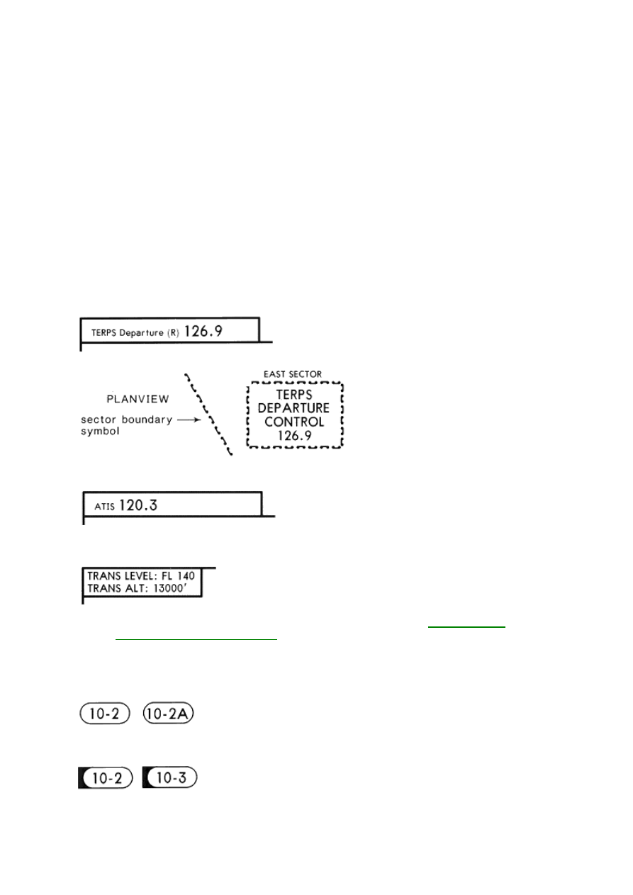
Departure Control frequencies are included with SIDs. The frequencies are listed in the heading of
the chart or when frequency sectors are specified they may be displayed in the planview of the chart.
HEADING
The ATIS frequency is provided on STARs in the heading of the chart.
The Transition Level and Transition Altitude are listed below the Communications.
For a complete explanation of Transition Level and Transition Altitude see
Approach Chart
Legend-Heading-Communications
.
CHART IDENTIFICATION
STARS/PROFILE DESCENTS
, etc.
Index number
Special chart issued to special coverages only. Contains modified information for your company.
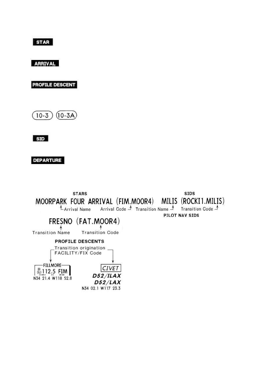
Standard Terminal Arrival
Arrival Procedure
Profile Descent
SIDS
, etc.
Index number
Standard Instrument Departure
Departure Procedure
ROUTE IDENTIFICATION - TYPICAL EXAMPLES USING COMPUTER LANGUAGE
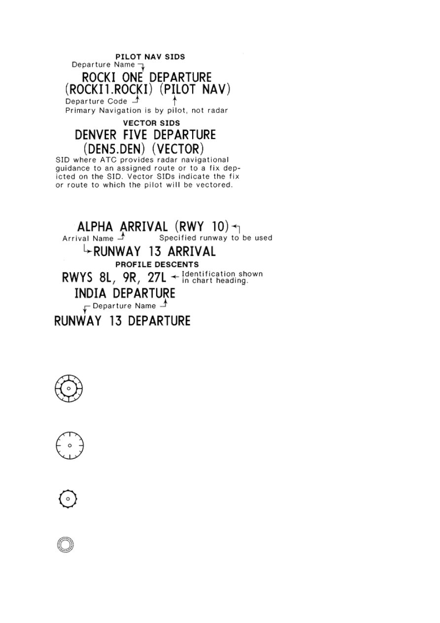
TYPICAL EXAMPLES NOT USING COMPUTER LANGUAGE
GRAPHIC - (Charts are not drawn at a specific scale)
RADIO SYMBOLS
VORTAC/VORDME
VOR (VHF Omnidirectional Range)
TACAN (Tactical Air Navigation) or DME (Distance Measuring Equipment)
NDB (Nondirectional Radio Beacon)
LOC, LDA, or SDF Front Course
LOC Back Course
Locator with Outer Marker (LOM)
Outer or Middle Marker (OM) (MM)
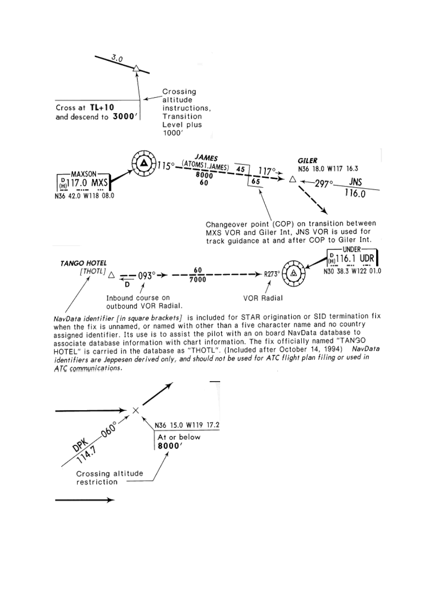
RADIO IDENTIFICATION
Navaid identification is given in shadow box with frequency, identifier, Morse Code and latitude &
longitude coordinates. DME capability is indicated by a small "D" preceding the VOR frequency at
frequency paired navaids. VOR and VORTAC facility operational ranges are identified (when
known) within the navaid box. (T) represents Terminal; (L) represents Low Altitude; and (H)
represents High Altitude.
Localizer navaids are identified by a round cornered box. Frequency identification and Morse Code
are provided. DME is included when navaid and DME are frequency paired. Localizer back course
facility boxes include front course bearing for HSI setting.
AIRSPACE FIXES
Non Compulsory Airspace Fixes.
Compulsory Airspace Fixes.
Fly-over Airspace Fixes.
VERTICAL NOISE ABATEMENT PROCEDURES
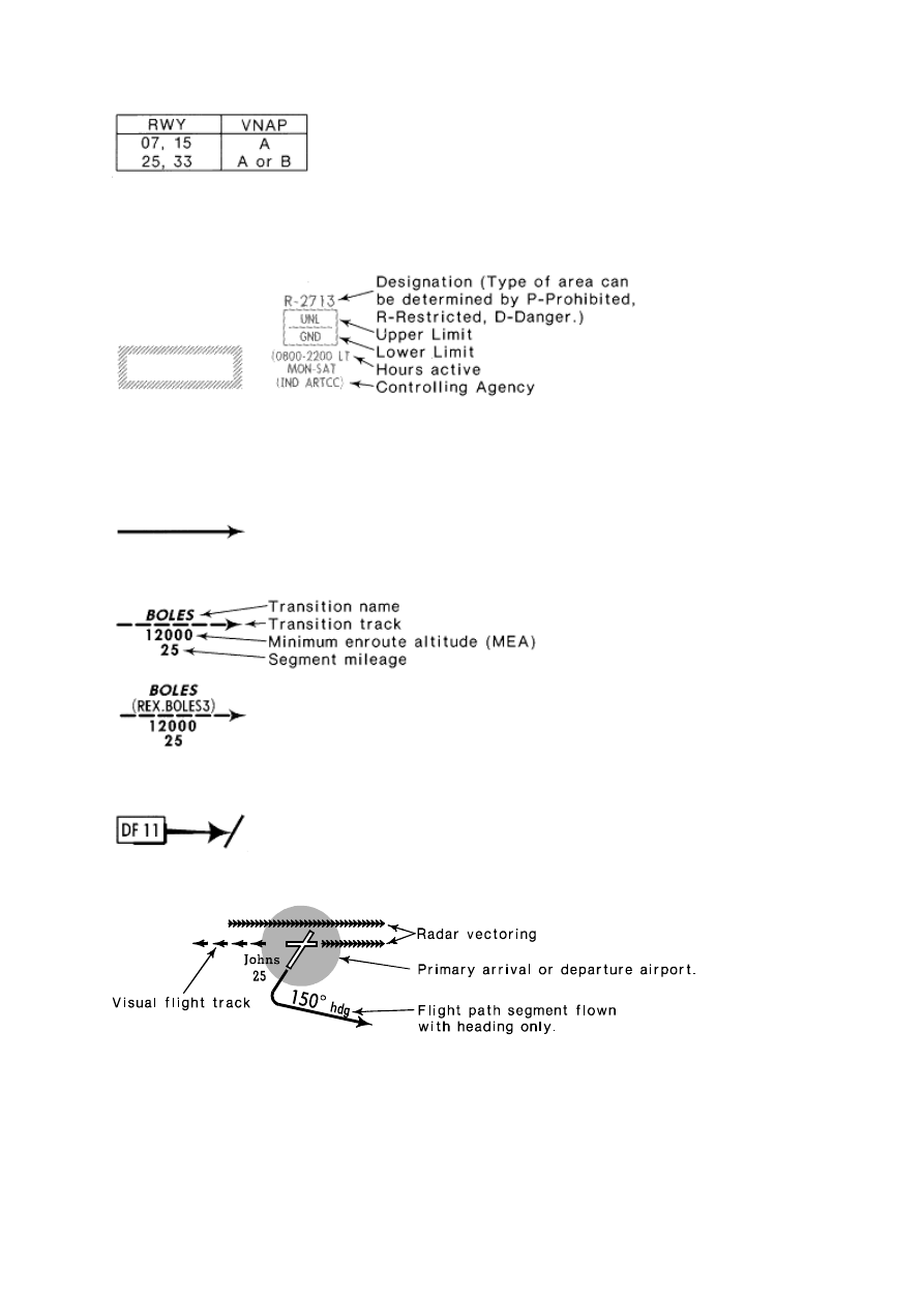
Vertical Noise Abatement Procedures (VNAP). For explanation of procedures, see
Air Traffic Control section.
RESTRICTED AIRSPACE
PROHIBITED, RESTRICTED, DANGER AREAS
Prohibited, Restricted & Danger Areas are charted when referenced in SID or STAR source, plus
any Prohibited Area within five (5) nautical miles of route centerline or primary airport.
ROUTE PORTRAYAL
SID/STAR Track
On charts dated on or after Jul 26, 1985 the Transition name will include the route identification code,
when assigned.
SID or STAR label of a particular route in some coverage areas
Profile Descent Track
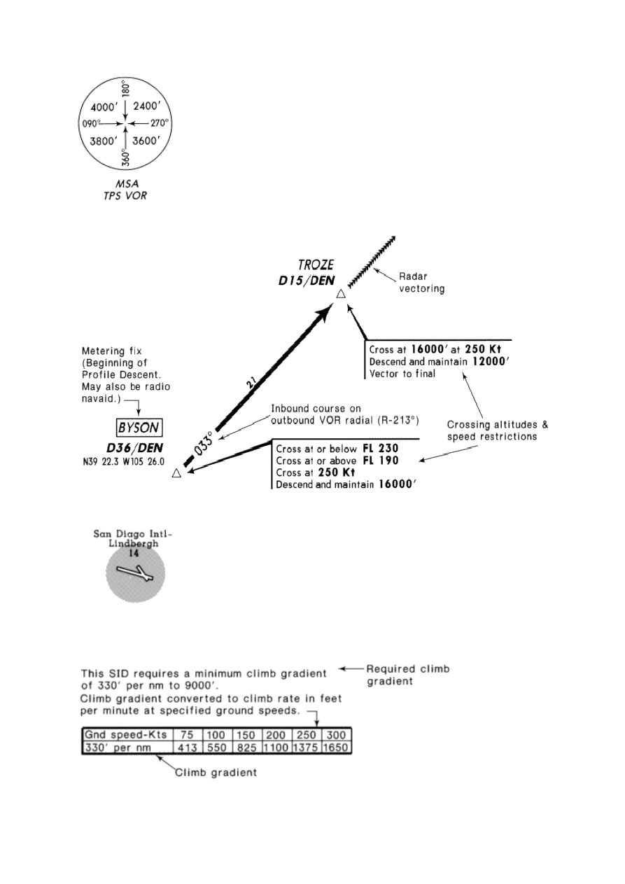
MSA is provided when specified by the controlling authority.
Arrival/departure airport, highlighted with circular screen after November, 1993
SID CLIMB GRADIENT/CLIMB RATE TABLE
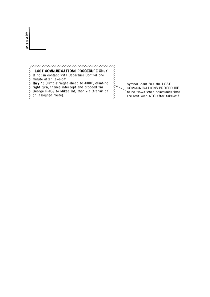
"MILITARY" notation indicates military source used for this procedure.
PROCEDURE APPLICABLE TO USA FAA ONLY
Standard Instrument Departures (SIDs)
Pilots of IFR civil aircraft operating from locations where SID procedures are effective may expect
ATC clearances containing a SID. Use of a SID requires possession of at least the textual
description of the SID. Pilots not desiring to use the SID are expected to advise ATC. Notification
may be accomplished by filing "NO SID" in the remarks section of the filed flight plan or by the less
desirable method of verbally advising ATC.
Obstacle clearance is based on the aircraft climbing at 200 feet per nautical mile, crossing the end of
the runway at 35 feet AGL, and climbing to 400 feet above the airport elevation before turning unless
otherwise specified in the procedure. A slope of 152 feet per mile, starting no higher than 35 feet
above the departure end of the runway, is assessed for obstacles. A minimum of 48 feet of obstacle
clearance is provided for each mile of flight. If no obstacles penetrate the 152 feet per mile slope,
IFR departure procedures are not published. If obstacles penetrate the slope, obstacle avoidance
procedures are specified. These procedures may be: a ceiling and visibility to allow the obstacles to
be seen and avoided; a climb gradient greater than 200 feet per mile; detailed flight maneuvers; or a
combination of the above. In extreme cases, IFR take-off may not be authorized for some runways.
Climb gradients are specified when required for obstacle clearance. Crossing restrictions in the SIDs
may be established for traffic separation or obstacle clearance. When no gradient is specified, the
pilot is expected to climb at least 200 feet per mile to MEA unless required to level off by a crossing
restriction. Climb gradients may be specified to an altitude/fix, above which the normal gradient
applies. Some procedures require a climb in visual conditions to cross the airport (or an on-airport
NAVAID) at or above an altitude. The specified ceiling and visibility minimums will be enough to
allow the pilot to see and avoid obstacles near the airport. Obstacle avoidance is not guaranteed if
the pilot maneuvers farther from the airport than the visibility minimum. That segment of the
procedure which requires the pilot to see and avoid obstacles ends when the aircraft crosses the
specified point at the required altitude. Thereafter, standard obstacle protection is provided.
SIDs are published in textual and graphic form in the Jeppesen manual and are located with the
appropriate airports.
Standard Terminal Arrivals (STARS)
PiIots of IFR civil aircraft destined to locations for which STARs have been published may be issued
a clearance containing a STAR whenever ATC deems it appropriate.
Use of STARs requires possession of at least the approved textual description. As with any ATC
clearance, it is the responsibility of each pilot to accept or refuse an issued STAR. A pilot should
notify ATC if he does not wish to use a STAR by placing "NO STAR" in the remarks section of the
flight plan or by the less desirable method of verbally advising ATC.
STARs are published in textual and graphic form in the Jeppesen manual.
Filing IFR Flight Plans with SIDs and STARs
When filing an IFR flight plan, the use of the associated codified FAA SID or STAR and transition
identifiers will greatly facilitate the acceptance of the flight plan in the ARTCC computer. These
identifier codes are found in the respective SID and STAR charts. The following explanation and
examples are the proper methods in filing SIDs and STARs.
When filing an IFR flight plan, the use of the associated codified FAA SID or STAR and transition
identifiers will greatly facilitate the acceptance of the flight plan in the ARTCC computer.
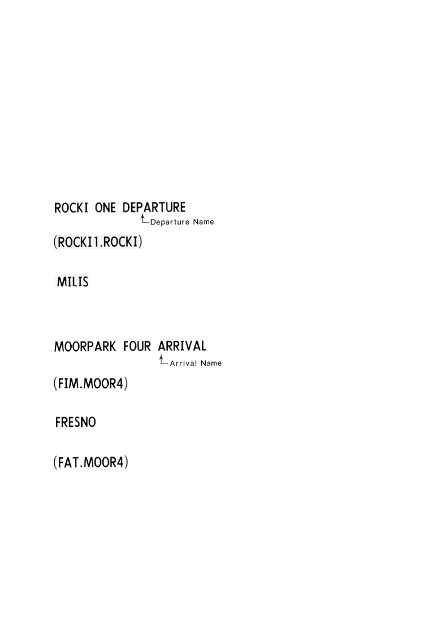
SIDs: When a SID is filed without using a transition the filed identifier (code) will read as
ROCKI1.ROCKI". When a transition is used the last coded characters of the SID are replaced by the
transition code and will read as "ROCKI1.MILIS
Departure Code
Transition Name
STARs: When a STAR is filed without using a transition, the filed identifier (code) will read as
"FIM.MOOR4". When a transition is used the first coded characters of the STAR are replaced by the
transition code and will read as FAT.MOOR4".
Arrival Code
Transition Name
Transition Code
Profile Descent Procedural Note
Profile Descent clearances are subject to traffic conditions and may be altered by ATC if necessary.
Acceptance, by the pilot, of a profile descent clearance; i.e., "cleared for Runway 28 profile descent,
" requires the pilot to adhere to all depicted procedures on the profile descent chart.
After a profile descent has been issued and accepted:
(1) Any subsequent ATC revision of altitude or route cancels the remaining portion of the charted
profile descent procedure. ATC will then assign necessary altitude, route, and speed

clearances.
(2) Any subsequent revision of depicted speed restriction voids all charted speed restrictions.
Charted route and altitude restrictions are not affected by revision to depicted speed restrictions.
If the pilot cannot comply with charted route and/or altitude restrictions because of revised
speed, he is expected to so advise ATC.
THE PROFILE DESCENT CLEARANCE DOES NOT CONSTITUTE CLEARANCE TO FLY AN
INSTRUMENT APPROACH PROCEDURE (IAP). The last "maintain altitude" specified in the
PROFILE DESCENT procedure constitutes the last ATC assigned altitude and the pilot must
maintain such altitude until he is cleared for an approach unless another altitude is assigned by ATC.
PILOTS SHOULD REVIEW RUNWAY PROFILE DESCENT CHARTS BEFORE FLIGHT INTO
AIRPORTS WITH CHARTED PROCEDURES.
Wyszukiwarka
Podobne podstrony:
ćw 4 Profil podłużny cieku
Profilaktyka nowotworowa
profilaktyka przeciwurazowa
Niezawodowa profilaktyka poekspozycyjna
profilaktyka nadcisnienia(2)
PROFILAKTYKA ZDROWIA
Profilaktyka przeciwzakrzepowa w chirurgii ogólnej, ortopedii i traumatologii
Profilaktyka poekspozycyjna zakażeń HBV, HCV, HIV
PROFILAKTYKA PREWENCJA A PROMOCJA ZDROWIA
crm star
Rodzina w systemie profilaktyki na szczeblu lokalnym
Profilaktyka wirusowa dla uczniów
Zastosowanie probiotyków i prebiotyków w profilaktyce i leczeniu ppt
Profilaktyka powikłań zakrzepowo zatorowych
więcej podobnych podstron